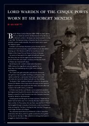
An important vellum manuscript chart of the Dutch East India Company
An important vellum manuscript chart of the Dutch East India Company
An important vellum manuscript chart of the Dutch East India Company

You also want an ePaper? Increase the reach of your titles
YUMPU automatically turns print PDFs into web optimized ePapers that Google loves.
The Gentlemen Seventeen, <strong>the</strong> highest authority board <strong>of</strong> <strong>the</strong> VOC, were careful that <strong>the</strong> maps<br />
and navigational equipment issued to navigation <strong>of</strong>ficers sent to <strong>the</strong> <strong>East</strong> Indies were returned<br />
and not discarded or sold to outsiders. In order to better exercise control over <strong>the</strong>se tools,<br />
experts in <strong>the</strong> field <strong>of</strong> navigation compiled lists <strong>of</strong> <strong>the</strong> necessary <strong>chart</strong>s and instruments.<br />
The lists (first handwritten, later printed) include a detailed overview <strong>of</strong> <strong>the</strong> instruments and<br />
cartographical material that were allocated, followed by <strong>the</strong> price <strong>of</strong> each item as determined<br />
by <strong>the</strong> <strong>Company</strong>.<br />
Each <strong>of</strong> <strong>the</strong> navigational <strong>of</strong>ficers (skipper, first steersman, and two second steersmen) had to<br />
sign <strong>the</strong> inventory upon receipt and was required to return all <strong>the</strong> material upon completing<br />
<strong>the</strong> journey to Batavia. In <strong>the</strong> event <strong>of</strong> missing or mishandled <strong>chart</strong>s, <strong>the</strong>y were fined an<br />
amount equal to twice <strong>the</strong> list price <strong>of</strong> <strong>the</strong> item in question.<br />
These lists were drawn up for <strong>the</strong> first time in 1655, and were regularly revised and adapted to<br />
navigational developments. Thus, for example, <strong>the</strong> lists <strong>of</strong> 1675, 1731 and 1747 were all<br />
improved. As <strong>of</strong> 1663 <strong>the</strong> lists were printed in order to avoid <strong>the</strong>ir frequent copying, so that<br />
only <strong>the</strong> names <strong>of</strong> <strong>the</strong> ship, ship’s <strong>of</strong>ficer and <strong>the</strong> date had to be filled in by hand.<br />
The printed list for <strong>the</strong> Zeeland Chamber that specifies <strong>the</strong> books, <strong>chart</strong>s and nautical<br />
instruments gives us a detailed insight <strong>of</strong> <strong>the</strong> equipment on board <strong>of</strong> an <strong>East</strong> <strong>India</strong>man <strong>of</strong> that<br />
period (ill. 4). Today <strong>the</strong>se lists are invaluable sources for our knowledge and understanding<br />
<strong>of</strong> <strong>the</strong> navigational equipment used by VOC vessels in <strong>the</strong> seventeenth and eighteenth<br />
centuries, and <strong>the</strong>y allow us to reconstruct <strong>the</strong> kind and number <strong>of</strong> <strong>chart</strong>s used. Thus, we now<br />
know that three or four sets <strong>of</strong> <strong>chart</strong>s were used for navigating from Zeeland to Batavia.<br />
While <strong>the</strong> list <strong>of</strong> 1675 refers almost exclusively to <strong>manuscript</strong> <strong>chart</strong>s, <strong>the</strong> revised list <strong>of</strong> 1731<br />
includes <strong>the</strong> first mention <strong>of</strong> <strong>the</strong> printed <strong>chart</strong>s which Johannes (II) van Keulen had only<br />
recently been permitted to supply to VOC ships. The much more expensive <strong>manuscript</strong> <strong>chart</strong>s<br />
were usually drawn on <strong>vellum</strong>, a sturdy material which was less prone to damage from<br />
climate and moisture as well as wear and tear. These <strong>chart</strong>s were never folded, after use <strong>the</strong>y<br />
were rolled up and stored in large tin containers.<br />
The contract between <strong>the</strong> Zeeland Chamber and Abraham <strong>An</strong>ias formalised that he had to<br />
supply all <strong>East</strong> <strong>India</strong>men <strong>of</strong> <strong>the</strong> Chamber with <strong>the</strong> necessary books, <strong>chart</strong>s and nautical<br />
instruments, as far as <strong>the</strong>y were not in local stock with <strong>the</strong> <strong>Company</strong>. In <strong>the</strong> first half <strong>of</strong> <strong>the</strong><br />
18th century, <strong>the</strong> majority <strong>of</strong> <strong>manuscript</strong> <strong>chart</strong>s on <strong>vellum</strong> was produced by <strong>the</strong> Amsterdam<br />
Chamber, i.e. Isaac de Graaf (1705-43) and his assistants. The Amsterdam Chamber also<br />
equipped <strong>the</strong> o<strong>the</strong>r five chambers with <strong>vellum</strong> <strong>chart</strong>s. Zeeland was <strong>the</strong> only o<strong>the</strong>r Chamber<br />
with a <strong>chart</strong>-making workshop. It was <strong>the</strong> responsibility <strong>of</strong> Abraham <strong>An</strong>ias to provide for<br />
<strong>chart</strong>s that were lacking at <strong>the</strong> Zeeland Chamber, by drawing <strong>the</strong>m in his own hand. Whereas<br />
worldwide eight <strong>vellum</strong> <strong>chart</strong>s <strong>of</strong> <strong>the</strong> <strong>India</strong>n Ocean are known by Isaac de Graaf, only one<br />
single o<strong>the</strong>r example has come to us from <strong>the</strong> hand <strong>of</strong> Abraham <strong>An</strong>ias (The Hague National<br />
Archives). This fact emphasizes <strong>the</strong> great significance and rarity <strong>of</strong> <strong>the</strong> item <strong>of</strong>fered here.<br />
Closer inspection <strong>of</strong> <strong>the</strong> 1731 list <strong>of</strong> <strong>chart</strong>s reveals that two different groups <strong>of</strong> <strong>chart</strong>s can be<br />
distinguished. One group consists <strong>of</strong> small-scale <strong>chart</strong>s that cover large parts <strong>of</strong> <strong>the</strong> area<br />
between Texel and Batavia, whereas <strong>the</strong> o<strong>the</strong>r group contains <strong>the</strong> large-scale <strong>chart</strong>s <strong>of</strong> small<br />
regions that are essential to navigate <strong>the</strong> difficult waters around Holland, <strong>the</strong> English Channel,<br />
<strong>the</strong> treacherous coasts around <strong>the</strong> Cape, and <strong>the</strong> navigation <strong>of</strong> <strong>the</strong> waters near Australia and<br />
<strong>the</strong> Indonesian Archipelago.