- Page 1 and 2: June 22, 2011 To: Georgia Departmen
- Page 3 and 4: June 22, 2011 Adair Court, L.P. 198
- Page 5 and 6: 4.1.2.10 Local/Regional Water Quali
- Page 7 and 8: APPENDICES Appendix A Figures and M
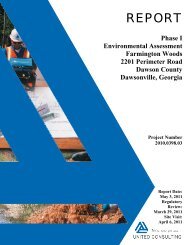
- Page 9 and 10: 1.0 EXECUTIVE SUMMARY 1 United Cons
- Page 11 and 12: 1.3.2 Off-Site United Consulting ha
- Page 13 and 14: • Site Use - This assessment was
- Page 15 and 16: future work to be performed in conn
- Page 17 and 18: Based on the USGS topographic map o
- Page 19 and 20: espective ASTM or AAI search distan
- Page 21 and 22: 4.1.1.1 Sites Listed in Section 8.2
- Page 23 and 24: No. Facility & Address Program 23 2
- Page 25 and 26: 4.1.2 Additional Environmental Reco
- Page 27 and 28: Water Quality Report was published.
- Page 29 and 30: 4.3.4.2 Environmental Liens The cli
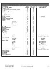
- Page 31 and 32: 5.4.3 Heating and Cooling No struct
- Page 33 and 34: 5.4.21 Radon 3 : United Consulting
- Page 35 and 36: The USGS 7.5-minute series quadrang
- Page 37 and 38: the EPD did not have reason to beli
- Page 39 and 40: TABLE 3: AREA RECONNAISSANCE INFORM
- Page 41 and 42: a search was conducted on the NAHRG
- Page 43: presence of the commercial business
- Page 47 and 48: APPENDIX A - FIGURES AND MAPS
- Page 50: APPENDIX A ________________________
- Page 54: APPENDIX A ________________________
- Page 57 and 58: United Consulting Project No. # Pho
- Page 59 and 60: United Consulting Project No. # Pho
- Page 61 and 62: United Consulting Project No. # Pho
- Page 63 and 64: APPENDIX C ________________________
- Page 65 and 66: EDR Aerial Photo Decade Package Env
- Page 67 and 68: INQUIRY #: YEAR: 1938 3085219.5 = 4
- Page 69 and 70: INQUIRY #: YEAR: 1955 3085219.5 = 4
- Page 71 and 72: INQUIRY #: YEAR: 1968 3085219.5 = 5
- Page 73 and 74: INQUIRY #: YEAR: 1986 3085219.5 = 9
- Page 75 and 76: INQUIRY #: YEAR: 1993 3085219.5 = 9
- Page 77 and 78: INQUIRY #: YEAR: 2006 3085219.5 = 6
- Page 79 and 80: Adair Court 806 Murphy Avenue Atlan
- Page 81 and 82: Sanborn Sheet Thumbnails This Certi
- Page 83 and 84: This Certified Sanborn Map combines
- Page 85 and 86: This Certified Sanborn Map combines
- Page 87 and 88: Adair Court 806 Murphy Avenue Atlan
- Page 89 and 90: N → TARGET QUAD NAME: ATLANTA MAP
- Page 91 and 92: N → TARGET QUAD NAME: SOUTHWEST A
- Page 93 and 94: N → TARGET QUAD NAME: SOUTHWEST A
- Page 95 and 96:
N → TARGET QUAD NAME: SOUTHWEST A
- Page 97 and 98:
APPENDIX D - DOCUMENTATION FROM TIT
- Page 99 and 100:
MURPHY ADAIR COURT DEEDS IN CHAIN O
- Page 101 and 102:
4. Deed from Mrs. Reba E. Westbrook
- Page 103:
2. Warranty Deed from W. B. Willing
- Page 107:
APPENDIX D ________________________
- Page 110 and 111:
APPENDIX E ________________________
- Page 112 and 113:
compounds (SVOCs), RCRA metals and
- Page 114 and 115:
APPENDIX E ________________________
- Page 116 and 117:
UNITED CONSULTING 625 Holcomb Bridg
- Page 118 and 119:
TABLE OF CONTENTS EXECUTIVE SUMMARY
- Page 120 and 121:
analysis. The concentrations of chr
- Page 122 and 123:
The Project Site is located in the
- Page 124 and 125:
Subsurface Conditions Borings TMW-1
- Page 126 and 127:
Chain-of-Custody Chain of Custody w
- Page 128 and 129:
The metals chromium, barium, and le
- Page 130 and 131:
The Project Site is currently liste
- Page 135:
APPENDIX A - BORING LOGS
- Page 142 and 143:
June 20, 2011 Ian Pilling United Co
- Page 144 and 145:
ANALYTICAL ENVIRONMENTAL SERVICES,
- Page 146 and 147:
Analytical Environmental Services,
- Page 148 and 149:
Analytical Environmental Services,
- Page 150 and 151:
Analytical Environmental Services,
- Page 152 and 153:
Analytical Environmental Services,
- Page 154 and 155:
Analytical Environmental Services,
- Page 156 and 157:
Analytical Environmental Services,
- Page 158 and 159:
Analytical Environmental Services,
- Page 160 and 161:
Analytical Environmental Services,
- Page 162 and 163:
Analytical Environmental Services,
- Page 164 and 165:
Analytical Environmental Services,
- Page 166 and 167:
Analytical Environmental Services,
- Page 168 and 169:
Analytical Environmental Services,
- Page 170 and 171:
Analytical Environmental Services,
- Page 172 and 173:
Analytical Environmental Services,
- Page 174 and 175:
Analytical Environmental Services,
- Page 176 and 177:
Analytical Environmental Services,
- Page 178 and 179:
Analytical Environmental Services,
- Page 180 and 181:
Analytical Environmental Services,
- Page 182 and 183:
Analytical Environmental Services,
- Page 184 and 185:
Analytical Environmental Services,
- Page 186 and 187:
Analytical Environmental Services,
- Page 188 and 189:
Analytical Environmental Services,
- Page 190 and 191:
Analytical Environmental Services,
- Page 192 and 193:
Analytical Environmental Services,
- Page 194 and 195:
Analytical Environmental Services,
- Page 196 and 197:
Analytical Environmental Services,
- Page 198 and 199:
Analytical Environmental Services,
- Page 200 and 201:
Analytical Environmental Services,
- Page 202 and 203:
Analytical Environmental Services,
- Page 204 and 205:
Analytical Environmental Services,
- Page 206 and 207:
Analytical Environmental Services,
- Page 208 and 209:
Analytical Environmental Services,
- Page 210 and 211:
Analytical Environmental Services,
- Page 212 and 213:
Page 2 of 19
- Page 214 and 215:
Analytical Environmental Services,
- Page 216 and 217:
Analytical Environmental Services,
- Page 218 and 219:
Analytical Environmental Services,
- Page 220 and 221:
Analytical Environmental Services,
- Page 222 and 223:
Analytical Environmental Services,
- Page 224 and 225:
Analytical Environmental Services,
- Page 226 and 227:
Analytical Environmental Services,
- Page 228 and 229:
Analytical Environmental Services,
- Page 230 and 231:
APPENDIX C - AUTHOR CREDENTIALS, DO
- Page 232 and 233:
UNITED CONSULTING RUSSELL C. GRIEBE
- Page 234 and 235:
UNITED CONSULTING IAN G. PILLING, L
- Page 236 and 237:
APPENDIX E ________________________
- Page 238 and 239:
APPENDIX E ________________________
- Page 240 and 241:
was performed in accordance with th
- Page 242:
Please contact us if you have any q
- Page 263 and 264:
NOT APPLICABLE
- Page 266 and 267:
APPENDIX E ________________________
- Page 268 and 269:
APPENDIX E ________________________
- Page 270 and 271:
APPENDIX E ________________________
- Page 272:
APPENDIX E ________________________
- Page 297 and 298:
Adair Court 806 Murphy Avenue Atlan
- Page 299 and 300:
EXECUTIVE SUMMARY A search of avail
- Page 301 and 302:
EXECUTIVE SUMMARY Local Lists of La
- Page 303 and 304:
EXECUTIVE SUMMARY State- and tribal
- Page 305 and 306:
EXECUTIVE SUMMARY State and tribal
- Page 307 and 308:
EXECUTIVE SUMMARY _________________
- Page 309 and 310:
1 0 0 0 1 0 4 0 1 0 0 0 EDR Inc. 1
- Page 311 and 312:
MAP FINDINGS SUMMARY Search Target
- Page 313 and 314:
MAP FINDINGS SUMMARY Search Target
- Page 315 and 316:
Map ID Direction Distance Elevation
- Page 317 and 318:
Map ID Direction Distance Elevation
- Page 319 and 320:
Map ID Direction Distance Elevation
- Page 321 and 322:
Map ID Direction Distance Elevation
- Page 323 and 324:
Map ID Direction Distance Elevation
- Page 325 and 326:
Map ID Direction Distance Elevation
- Page 327 and 328:
Map ID Direction Distance Elevation
- Page 329 and 330:
Map ID Direction Distance Elevation
- Page 331 and 332:
Map ID Direction Distance Elevation
- Page 333 and 334:
Map ID Direction Distance Elevation
- Page 335 and 336:
Map ID Direction Distance Elevation
- Page 337 and 338:
Map ID Direction Distance Elevation
- Page 339 and 340:
Map ID Direction Distance Elevation
- Page 341 and 342:
Map ID Direction Distance Elevation
- Page 343 and 344:
Map ID Direction Distance Elevation
- Page 345 and 346:
Map ID Direction Distance Elevation
- Page 347 and 348:
Map ID Direction Distance Elevation
- Page 349 and 350:
Map ID Direction Distance Elevation
- Page 351 and 352:
Map ID Direction Distance Elevation
- Page 353 and 354:
Map ID Direction Distance Elevation
- Page 355 and 356:
Map ID Direction Distance Elevation
- Page 357 and 358:
Map ID Direction Distance Elevation
- Page 359 and 360:
Map ID Direction Distance Elevation
- Page 361 and 362:
Map ID Direction Distance Elevation
- Page 363 and 364:
Map ID Direction Distance Elevation
- Page 365 and 366:
Map ID Direction Distance Elevation
- Page 367 and 368:
Map ID Direction Distance Elevation
- Page 369 and 370:
Map ID Direction Distance Elevation
- Page 371 and 372:
Map ID Direction Distance Elevation
- Page 373 and 374:
Map ID Direction Distance Elevation
- Page 375 and 376:
Map ID Direction Distance Elevation
- Page 377 and 378:
Map ID Direction Distance Elevation
- Page 379 and 380:
Map ID Direction Distance Elevation
- Page 381 and 382:
Map ID Direction Distance Elevation
- Page 383 and 384:
Map ID Direction Distance Elevation
- Page 385 and 386:
Map ID Direction Distance Elevation
- Page 387 and 388:
Map ID Direction Distance Elevation
- Page 389 and 390:
Map ID Direction Distance Elevation
- Page 391 and 392:
Map ID Direction Distance Elevation
- Page 393 and 394:
Map ID Direction Distance Elevation
- Page 395 and 396:
Map ID Direction Distance Elevation
- Page 397 and 398:
Map ID Direction Distance Elevation
- Page 399 and 400:
GOVERNMENT RECORDS SEARCHED / DATA
- Page 401 and 402:
GOVERNMENT RECORDS SEARCHED / DATA
- Page 403 and 404:
GOVERNMENT RECORDS SEARCHED / DATA
- Page 405 and 406:
GOVERNMENT RECORDS SEARCHED / DATA
- Page 407 and 408:
GOVERNMENT RECORDS SEARCHED / DATA
- Page 409 and 410:
GOVERNMENT RECORDS SEARCHED / DATA
- Page 411 and 412:
GOVERNMENT RECORDS SEARCHED / DATA
- Page 413 and 414:
GOVERNMENT RECORDS SEARCHED / DATA
- Page 415 and 416:
GOVERNMENT RECORDS SEARCHED / DATA
- Page 417 and 418:
GOVERNMENT RECORDS SEARCHED / DATA
- Page 419 and 420:
TARGET PROPERTY ADDRESS TARGET PROP
- Page 421 and 422:
HYDROLOGIC INFORMATION FEMA FLOOD Z
- Page 423 and 424:
1 WELL SEARCH DISTANCE INFORMATION
- Page 425 and 426:
0 0 0 0 0 9 6 0 1 0 0 0 9 6 0 9 6 0
- Page 427 and 428:
Agency cd: USGS Site no: 3344160842
- Page 429 and 430:
AREA RADON INFORMATION Number of si
- Page 431 and 432:
LOCAL / REGIONAL WATER AGENCY RECOR
- Page 433 and 434:
HUFFINE PROPERTIES BETWEEN MURPHY A
- Page 435 and 436:
AREA FACILITY WASTE MANAGEMENT Faci
- Page 437 and 438:
SECTION 3: DATABASES AND UPDATE DAT
- Page 439:
APPENDIX G ________________________
- Page 444 and 445:
UNITED CONSULTING RECORD OF COMMUNI
- Page 446:
APPENDIX G ________________________
- Page 449:
UNITED CONSULTING RECORD OF COMMUNI
- Page 452 and 453:
UNITED CONSULTING RECORD OF COMMUNI
- Page 455 and 456:
APPENDIX H - AUTHOR CREDENTIALS, DO
- Page 457 and 458:
UNITED CONSULTING SCOTT D. SMELTER
- Page 459 and 460:
UNITED CONSULTING TIMOTHY J. BECK,
- Page 461 and 462:
UNITED CONSULTING DAVID P. HUETTER
- Page 463 and 464:
UNITED CONSULTING IAN G. PILLING, L
- Page 467 and 468:
Report of Phase I Environmental Sit
- Page 469 and 470:
Report of Phase I Environmental Sit
- Page 471 and 472:
Report of Phase I Environmental Sit
- Page 473 and 474:
Report of Phase I Environmental Sit
- Page 475 and 476:
Report of Phase I Environmental Sit
- Page 477 and 478:
Report of Phase I Environmental Sit
- Page 479 and 480:
Report of Phase I Environmental Sit
- Page 481 and 482:
Report of Phase I Environmental Sit
- Page 483 and 484:
Report of Phase I Environmental Sit
- Page 485 and 486:
Report of Phase I Environmental Sit
- Page 487 and 488:
Report of Phase I Environmental Sit
- Page 489 and 490:
Report of Phase I Environmental Sit
- Page 491 and 492:
Report of Phase I Environmental Sit
- Page 493 and 494:
Report of Phase I Environmental Sit
- Page 495 and 496:
Report of Phase I Environmental Sit
- Page 497 and 498:
Report of Phase I Environmental Sit
- Page 499 and 500:
Report of Phase I Environmental Sit
- Page 502 and 503:
Report of Phase I Environmental Sit
- Page 506 and 507:
Report of Phase I Environmental Sit
- Page 508 and 509:
Report of Phase I Environmental Sit
- Page 510 and 511:
Report of Phase I Environmental Sit
- Page 512 and 513:
SECTION PAGE Executive Summary ES1
- Page 514 and 515:
EXECUTIVE SUMMARY Proposed NPL Prop
- Page 516 and 517:
EDR PROPRIETARY RECORDS EXECUTIVE S
- Page 518 and 519:
EXECUTIVE SUMMARY _________________
- Page 520 and 521:
EXECUTIVE SUMMARY Other Ascertainab
- Page 522 and 523:
EXECUTIVE SUMMARY Due to poor or in
- Page 524 and 525:
1040 EDR Inc. 1040 1040
- Page 526 and 527:
MAP FINDINGS SUMMARY Search Target
- Page 528 and 529:
Map ID Direction Distance Elevation
- Page 530 and 531:
Map ID Direction Distance Elevation
- Page 532 and 533:
Map ID Direction Distance Elevation
- Page 534 and 535:
Map ID Direction Distance Elevation
- Page 536 and 537:
Map ID Direction Distance Elevation
- Page 538 and 539:
Map ID Direction Distance Elevation
- Page 540 and 541:
Map ID Direction Distance Elevation
- Page 542 and 543:
Map ID Direction Distance Elevation
- Page 544 and 545:
Map ID Direction Distance Elevation
- Page 546 and 547:
Map ID Direction Distance Elevation
- Page 548 and 549:
Map ID Direction Distance Elevation
- Page 550 and 551:
Map ID Direction Distance Elevation
- Page 552 and 553:
Map ID Direction Distance Elevation
- Page 554 and 555:
Map ID Direction Distance Elevation
- Page 556 and 557:
Map ID Direction Distance Elevation
- Page 558 and 559:
Map ID Direction Distance Elevation
- Page 560 and 561:
Map ID Direction Distance Elevation
- Page 562 and 563:
Map ID Direction Distance Elevation
- Page 564 and 565:
Map ID Direction Distance Elevation
- Page 566 and 567:
Map ID Direction Distance Elevation
- Page 568 and 569:
Map ID Direction Distance Elevation
- Page 570 and 571:
Map ID Direction Distance Elevation
- Page 572 and 573:
Map ID Direction Distance Elevation
- Page 574 and 575:
Map ID Direction Distance Elevation
- Page 576 and 577:
Map ID Direction Distance Elevation
- Page 578 and 579:
Map ID Direction Distance Elevation
- Page 580 and 581:
Map ID Direction Distance Elevation
- Page 582 and 583:
Map ID Direction Distance Elevation
- Page 584 and 585:
Map ID Direction Distance Elevation
- Page 586 and 587:
Map ID Direction Distance Elevation
- Page 588 and 589:
Map ID Direction Distance Elevation
- Page 590 and 591:
Map ID Direction Distance Elevation
- Page 592 and 593:
Map ID Direction Distance Elevation
- Page 594 and 595:
Map ID Direction Distance Elevation
- Page 596 and 597:
Map ID Direction Distance Elevation
- Page 598 and 599:
Map ID Direction Distance Elevation
- Page 600 and 601:
Map ID Direction Distance Elevation
- Page 602 and 603:
Map ID Direction Distance Elevation
- Page 604 and 605:
Map ID Direction Distance Elevation
- Page 606 and 607:
Map ID Direction Distance Elevation
- Page 608 and 609:
Map ID Direction Distance Elevation
- Page 610 and 611:
Count: 20 records. ORPHAN SUMMARY C
- Page 612 and 613:
EDR ZIP Code Scan Report ZIP EDR-ID
- Page 614 and 615:
EDR ZIP Code Scan Report ZIP EDR-ID
- Page 616 and 617:
EDR ZIP Code Scan Report ZIP EDR-ID
- Page 618 and 619:
EDR ZIP Code Scan Report ZIP EDR-ID
- Page 620 and 621:
EDR ZIP Code Scan Report ZIP EDR-ID
- Page 622 and 623:
EDR ZIP Code Scan Report ZIP EDR-ID
- Page 624 and 625:
EDR ZIP Code Scan Report ZIP EDR-ID
- Page 626 and 627:
EDR ZIP Code Scan Report ZIP EDR-ID
- Page 628 and 629:
EDR ZIP Code Scan Report ZIP EDR-ID
- Page 630 and 631:
EDR ZIP Code Scan Report ZIP EDR-ID
- Page 632 and 633:
EDR ZIP Code Scan Report ZIP EDR-ID
- Page 634 and 635:
EDR ZIP Code Scan Report ZIP EDR-ID
- Page 636 and 637:
EDR ZIP Code Scan Report ZIP EDR-ID
- Page 638 and 639:
GOVERNMENT RECORDS SEARCHED / DATA
- Page 640 and 641:
GOVERNMENT RECORDS SEARCHED / DATA
- Page 642 and 643:
GOVERNMENT RECORDS SEARCHED / DATA
- Page 644 and 645:
GOVERNMENT RECORDS SEARCHED / DATA
- Page 646 and 647:
GOVERNMENT RECORDS SEARCHED / DATA
- Page 648 and 649:
GOVERNMENT RECORDS SEARCHED / DATA
- Page 650 and 651:
GOVERNMENT RECORDS SEARCHED / DATA
- Page 652 and 653:
GOVERNMENT RECORDS SEARCHED / DATA
- Page 654 and 655:
GOVERNMENT RECORDS SEARCHED / DATA
- Page 656 and 657:
GOVERNMENT RECORDS SEARCHED / DATA
- Page 658 and 659:
TARGET PROPERTY ADDRESS 806 MURPHY
- Page 660 and 661:
HYDROLOGIC INFORMATION FEMA FLOOD Z
- Page 662 and 663:
1 WELL SEARCH DISTANCE INFORMATION
- Page 664 and 665:
0 1 0 0 0 9 6 0 1 0 0 0 9 6 0 9 6 0
- Page 666 and 667:
Agency cd: USGS Site no: 3344160842
- Page 668 and 669:
AREA RADON INFORMATION Number of si
- Page 670 and 671:
LOCAL / REGIONAL WATER AGENCY RECOR
- Page 672:
Report of Phase I Environmental Sit
- Page 680 and 681:
Report of Phase I Environmental Sit
- Page 682 and 683:
industrial properties throughout th
- Page 684:
Mr. Foley has also been involved in
- Page 787:
APPENDIX J ________________________
- Page 823 and 824:
NOT APPLICABLE
- Page 825 and 826:
APPENDIX K ________________________
- Page 827 and 828:
PART A—TO BE COMPLETED BY THE APP
- Page 829 and 830:
( ) (x ) Chemical tank-car terminal
- Page 831 and 832:
Soil Stability, Erosion, and Draina
- Page 833 and 834:
Floodplain Management Yes No ( ) (x
- Page 835 and 836:
If your answer is “Yes” to any
- Page 837:
PART C—TO BE COMPLETED BY APPLICA
- Page 843 and 844:
SHIRLEV CLARKE FRANKLIN MAYOR CITY
- Page 845 and 846:
NOT APPLICABLE
- Page 859 and 860:
APPENDIX M - PROPERTY LOG AND INFOR
- Page 861 and 862:
portion of the Project Site. A Phas
- Page 863 and 864:
APPENDIX N - PROOF OF INSURANCE
- Page 866:
APPENDIX O - LETTERS OF REFERENCE
- Page 878 and 879:
APPENDIX Q - CONSUMER CONFIDENCE RE
- Page 880:
Our Clean Water Commitment The City
- Page 886 and 887:
APPENDIX S - SHPO REVIEW DOCUMENTAT
- Page 888 and 889:
G. Contact Information: Applicant C
- Page 890:
C. Are any of the buildings or stru
- Page 894 and 895:
NOT APPLICABLE
- Page 897 and 898:
Adair Court 806 Murphy Avenue SW At
- Page 899 and 900:
DESCRIPTION EXECUTIVE SUMMARY Envir
- Page 901 and 902:
TARGET PROPERTY INFORMATION ADDRESS
- Page 903 and 904:
Year Uses Source FINDINGS Year Uses
- Page 905 and 906:
Year Uses Source FINDINGS Year Uses
- Page 907 and 908:
Year Uses Source FINDINGS 845 LEE S
- Page 909 and 910:
Year Uses Source FINDINGS Year Uses
- Page 911 and 912:
Year Uses Source FINDINGS Year Uses
- Page 913 and 914:
Year Uses Source FINDINGS 823 LEE S
- Page 915 and 916:
Year Uses Source FINDINGS Year Uses
- Page 917 and 918:
Year Uses Source FINDINGS Year Uses
- Page 919 and 920:
Year Uses Source FINDINGS Year Uses
- Page 921 and 922:
Year Uses Source FINDINGS Year Uses
- Page 923 and 924:
Year Uses Source FINDINGS 750 LILLI
- Page 925 and 926:
Year Uses Source FINDINGS 759 LOWND
- Page 927 and 928:
Year Uses Source FINDINGS 786 LOWND
- Page 929 and 930:
Year Uses Source FINDINGS 806 LOWND
- Page 931 and 932:
Year Uses Source FINDINGS 740 MURPH
- Page 933 and 934:
Year Uses Source FINDINGS 888 MURPH
- Page 935 and 936:
Year Uses Source FINDINGS Year Uses
- Page 937 and 938:
Year Uses Source FINDINGS Year Uses
- Page 939 and 940:
Year Uses Source FINDINGS Year Uses
- Page 941 and 942:
Year Uses Source FINDINGS Year Uses
- Page 943 and 944:
Year Uses Source FINDINGS Year Uses
- Page 945 and 946:
Year Uses Source FINDINGS W WHITEHA
- Page 947 and 948:
Year Uses Source FINDINGS Year Uses
- Page 949 and 950:
Year Uses Source FINDINGS WHITE St
- Page 951 and 952:
FINDINGS Address Researched Address
- Page 953 and 954:
FINDINGS Address Researched Address
- Page 955 and 956:
FINDINGS Address Researched Address
- Page 957 and 958:
FINDINGS Address Researched Address
- Page 959 and 960:
Source Page Images Appendix
- Page 961 and 962:
Details For: Year MURPHY AVE 1916 S
- Page 963 and 964:
Details For: Year BEECHER SW 1927 S
- Page 965 and 966:
Details For: Year LILLIAN AVE SW 19
- Page 967 and 968:
Details For: Year MURPHY AVE SW 192
- Page 969 and 970:
Details For: Year SHELTON AVE SW 19
- Page 971 and 972:
Details For: Year BEECHER St SW 193
- Page 973 and 974:
Details For: Year LEE St SW 1932 So
- Page 975 and 976:
Details For: Year LOWNDES AVE SW 19
- Page 977:
Details For: Year SHELTON AVE SW 19