watervulnerability
watervulnerability watervulnerability
Grand Mesa, Uncompahgre and Gunnison National Forest Watershed Vulnerability Assessment, Rocky Mountain Region (R2) Figure 14. Coldwater Fisheries and Known Cutthroat Trout Occurrences Initially, the list of aquatic ecological values to be evaluated in this WVA was more extensive. Springs were identified as an important resource value likely to be affected by climate change; however, the spring inventory for the Forest is very limited. Boreal toad (Anaxyrus boreas boreas, a sensitive species) was not included because known occurrences are limited to very few sites on the Forest, and evaluation of effects to riparian habitats would address the effects to boreal toads and other amphibian species. Four warm water-sensitive fish species (bluehead sucker (Catostomus discobolus), flannelmouth sucker (C. latipinnis), mountain sucker (C. platyrhynchus), and roundtail chub (Gila robusta)) were also not included in the WVA because of limited data on occurrence and stream temperatures. Botanical species and communities were eliminated from consideration because general effects to their habitat would also be addressed through riparian habitats. Aquatic ecological value metrics were designed to compare subwatersheds in a more relative way. For each individual value, the results were standardized (results for each subwatershed were divided by the largest result of all the subwatersheds). The standardized results for each value were then summed to get a cumulative aquatic ecological value (Fen/wetland/riparian habitat + coldwater fisheries + cutthroat trout fisheries = Aquatic Ecological Value Ranking). The cumulative Aquatic Ecological Value Rankings were classified into quartiles. The top 25% were classified 3 (high), middle 50% were classified 2 (moderate), lowest 25% were classified 1 (low). Figure 15 shows the resulting Aquatic Ecological Values Ranking. 80 Assessing the Vulnerability of Watersheds to Climate Change
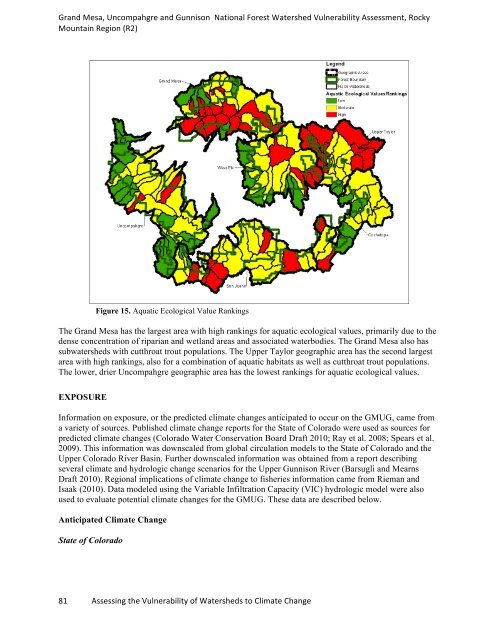
Grand Mesa, Uncompahgre and Gunnison National Forest Watershed Vulnerability Assessment, Rocky Mountain Region (R2) Figure 15. Aquatic Ecological Value Rankings The Grand Mesa has the largest area with high rankings for aquatic ecological values, primarily due to the dense concentration of riparian and wetland areas and associated waterbodies. The Grand Mesa also has subwatersheds with cutthroat trout populations. The Upper Taylor geographic area has the second largest area with high rankings, also for a combination of aquatic habitats as well as cutthroat trout populations. The lower, drier Uncompahgre geographic area has the lowest rankings for aquatic ecological values. EXPOSURE Information on exposure, or the predicted climate changes anticipated to occur on the GMUG, came from a variety of sources. Published climate change reports for the State of Colorado were used as sources for predicted climate changes (Colorado Water Conservation Board Draft 2010; Ray et al. 2008; Spears et al. 2009). This information was downscaled from global circulation models to the State of Colorado and the Upper Colorado River Basin. Further downscaled information was obtained from a report describing several climate and hydrologic change scenarios for the Upper Gunnison River (Barsugli and Mearns Draft 2010). Regional implications of climate change to fisheries information came from Rieman and Isaak (2010). Data modeled using the Variable Infiltration Capacity (VIC) hydrologic model were also used to evaluate potential climate changes for the GMUG. These data are described below. Anticipated Climate Change State of Colorado 81 Assessing the Vulnerability of Watersheds to Climate Change
- Page 34 and 35: Assessment of Watershed Vulnerabili
- Page 36 and 37: Gallatin National Forest Watershed
- Page 38 and 39: Gallatin National Forest Watershed
- Page 40 and 41: Gallatin National Forest Watershed
- Page 42 and 43: Gallatin National Forest Watershed
- Page 44 and 45: Gallatin National Forest Watershed
- Page 46 and 47: Gallatin National Forest Watershed
- Page 48 and 49: Gallatin National Forest Watershed
- Page 50 and 51: Assessment of Watershed Vulnerabili
- Page 52 and 53: Helena National Forest Watershed Vu
- Page 54 and 55: Helena National Forest Watershed Vu
- Page 56 and 57: Helena National Forest Watershed Vu
- Page 58 and 59: Helena National Forest Watershed Vu
- Page 60 and 61: Helena National Forest Watershed Vu
- Page 62 and 63: Helena National Forest Watershed Vu
- Page 64 and 65: Helena National Forest Watershed Vu
- Page 66 and 67: Helena National Forest Watershed Vu
- Page 68 and 69: Assessment of Watershed Vulnerabili
- Page 70 and 71: Grand Mesa, Uncompahgre and Gunniso
- Page 72 and 73: Grand Mesa, Uncompahgre and Gunniso
- Page 74 and 75: Grand Mesa, Uncompahgre and Gunniso
- Page 76 and 77: Grand Mesa, Uncompahgre and Gunniso
- Page 78 and 79: Grand Mesa, Uncompahgre and Gunniso
- Page 80 and 81: Grand Mesa, Uncompahgre and Gunniso
- Page 82 and 83: Grand Mesa, Uncompahgre and Gunniso
- Page 86 and 87: Grand Mesa, Uncompahgre and Gunniso
- Page 88 and 89: Grand Mesa, Uncompahgre and Gunniso
- Page 90 and 91: Grand Mesa, Uncompahgre and Gunniso
- Page 92 and 93: Grand Mesa, Uncompahgre and Gunniso
- Page 94 and 95: Grand Mesa, Uncompahgre and Gunniso
- Page 96 and 97: Grand Mesa, Uncompahgre and Gunniso
- Page 98 and 99: Grand Mesa, Uncompahgre and Gunniso
- Page 100 and 101: Grand Mesa, Uncompahgre and Gunniso
- Page 102 and 103: Grand Mesa, Uncompahgre and Gunniso
- Page 104 and 105: Grand Mesa, Uncompahgre and Gunniso
- Page 106 and 107: Grand Mesa, Uncompahgre and Gunniso
- Page 108 and 109: Grand Mesa, Uncompahgre and Gunniso
- Page 110 and 111: Grand Mesa, Uncompahgre and Gunniso
- Page 112 and 113: Grand Mesa, Uncompahgre and Gunniso
- Page 114 and 115: Grand Mesa, Uncompahgre and Gunniso
- Page 116 and 117: Assessment of Watershed Vulnerabili
- Page 118 and 119: White River National Forest Watersh
- Page 120 and 121: White River National Forest Watersh
- Page 122 and 123: White River National Forest Watersh
- Page 124 and 125: White River National Forest Watersh
- Page 126 and 127: White River National Forest Watersh
- Page 128 and 129: White River National Forest Watersh
- Page 130 and 131: White River National Forest Watersh
- Page 132 and 133: White River National Forest Watersh
Grand Mesa, Uncompahgre and Gunnison National Forest Watershed Vulnerability Assessment, Rocky<br />
Mountain Region (R2)<br />
Figure 15. Aquatic Ecological Value Rankings<br />
The Grand Mesa has the largest area with high rankings for aquatic ecological values, primarily due to the<br />
dense concentration of riparian and wetland areas and associated waterbodies. The Grand Mesa also has<br />
subwatersheds with cutthroat trout populations. The Upper Taylor geographic area has the second largest<br />
area with high rankings, also for a combination of aquatic habitats as well as cutthroat trout populations.<br />
The lower, drier Uncompahgre geographic area has the lowest rankings for aquatic ecological values.<br />
EXPOSURE<br />
Information on exposure, or the predicted climate changes anticipated to occur on the GMUG, came from<br />
a variety of sources. Published climate change reports for the State of Colorado were used as sources for<br />
predicted climate changes (Colorado Water Conservation Board Draft 2010; Ray et al. 2008; Spears et al.<br />
2009). This information was downscaled from global circulation models to the State of Colorado and the<br />
Upper Colorado River Basin. Further downscaled information was obtained from a report describing<br />
several climate and hydrologic change scenarios for the Upper Gunnison River (Barsugli and Mearns<br />
Draft 2010). Regional implications of climate change to fisheries information came from Rieman and<br />
Isaak (2010). Data modeled using the Variable Infiltration Capacity (VIC) hydrologic model were also<br />
used to evaluate potential climate changes for the GMUG. These data are described below.<br />
Anticipated Climate Change<br />
State of Colorado<br />
81 Assessing the Vulnerability of Watersheds to Climate Change


