watervulnerability
watervulnerability watervulnerability
Assessment of Watershed Vulnerability to Climate Change Grand Mesa, Uncompahgre and Gunnison National Forests March, 2012 Prepared by: Carol S. Howe Resource Information Specialist, Climate Change Coordinator and John Almy, Clay Speas, Warren Young and Ben Stratton, Grand Mesa, Uncompahgre and Gunnison National Forests, Delta, Colorado 64 Assessing the Vulnerability of Watersheds to Climate Change
Grand Mesa, Uncompahgre and Gunnison National Forest Watershed Vulnerability Assessment, Rocky Mountain Region (R2) LOCATION The Grand Mesa, Uncompahgre, and Gunnison National Forests (GMUG) are located in western Colorado (Figure 1), within the Rocky Mountain Region (R2) of the USFS. Figure 1. Grand Mesa, Uncompahgre, and Gunnison National Forest vicinity map The GMUG is also located within the headwaters of the Upper Colorado River Basin (Figure 2). 65 Assessing the Vulnerability of Watersheds to Climate Change
- Page 18 and 19: climate (Casola et al. 2005). Only
- Page 20 and 21: sensitivity. Most were derived from
- Page 22 and 23: The sensitivity evaluation typicall
- Page 24 and 25: in exposure. The result of combinin
- Page 26 and 27: highest priority for management act
- Page 28 and 29: to information affected the assessm
- Page 30 and 31: with and rely on in many resource d
- Page 32 and 33: Pilot National Forest Reports Conte
- Page 34 and 35: Assessment of Watershed Vulnerabili
- Page 36 and 37: Gallatin National Forest Watershed
- Page 38 and 39: Gallatin National Forest Watershed
- Page 40 and 41: Gallatin National Forest Watershed
- Page 42 and 43: Gallatin National Forest Watershed
- Page 44 and 45: Gallatin National Forest Watershed
- Page 46 and 47: Gallatin National Forest Watershed
- Page 48 and 49: Gallatin National Forest Watershed
- Page 50 and 51: Assessment of Watershed Vulnerabili
- Page 52 and 53: Helena National Forest Watershed Vu
- Page 54 and 55: Helena National Forest Watershed Vu
- Page 56 and 57: Helena National Forest Watershed Vu
- Page 58 and 59: Helena National Forest Watershed Vu
- Page 60 and 61: Helena National Forest Watershed Vu
- Page 62 and 63: Helena National Forest Watershed Vu
- Page 64 and 65: Helena National Forest Watershed Vu
- Page 66 and 67: Helena National Forest Watershed Vu
- Page 70 and 71: Grand Mesa, Uncompahgre and Gunniso
- Page 72 and 73: Grand Mesa, Uncompahgre and Gunniso
- Page 74 and 75: Grand Mesa, Uncompahgre and Gunniso
- Page 76 and 77: Grand Mesa, Uncompahgre and Gunniso
- Page 78 and 79: Grand Mesa, Uncompahgre and Gunniso
- Page 80 and 81: Grand Mesa, Uncompahgre and Gunniso
- Page 82 and 83: Grand Mesa, Uncompahgre and Gunniso
- Page 84 and 85: Grand Mesa, Uncompahgre and Gunniso
- Page 86 and 87: Grand Mesa, Uncompahgre and Gunniso
- Page 88 and 89: Grand Mesa, Uncompahgre and Gunniso
- Page 90 and 91: Grand Mesa, Uncompahgre and Gunniso
- Page 92 and 93: Grand Mesa, Uncompahgre and Gunniso
- Page 94 and 95: Grand Mesa, Uncompahgre and Gunniso
- Page 96 and 97: Grand Mesa, Uncompahgre and Gunniso
- Page 98 and 99: Grand Mesa, Uncompahgre and Gunniso
- Page 100 and 101: Grand Mesa, Uncompahgre and Gunniso
- Page 102 and 103: Grand Mesa, Uncompahgre and Gunniso
- Page 104 and 105: Grand Mesa, Uncompahgre and Gunniso
- Page 106 and 107: Grand Mesa, Uncompahgre and Gunniso
- Page 108 and 109: Grand Mesa, Uncompahgre and Gunniso
- Page 110 and 111: Grand Mesa, Uncompahgre and Gunniso
- Page 112 and 113: Grand Mesa, Uncompahgre and Gunniso
- Page 114 and 115: Grand Mesa, Uncompahgre and Gunniso
- Page 116 and 117: Assessment of Watershed Vulnerabili
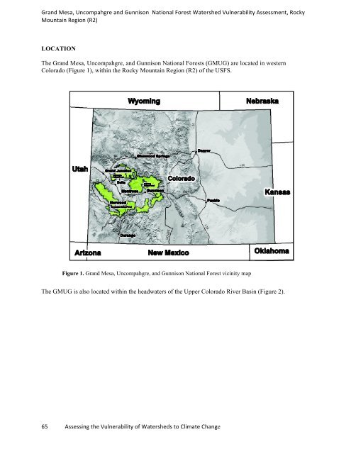
Grand Mesa, Uncompahgre and Gunnison National Forest Watershed Vulnerability Assessment, Rocky<br />
Mountain Region (R2)<br />
LOCATION<br />
The Grand Mesa, Uncompahgre, and Gunnison National Forests (GMUG) are located in western<br />
Colorado (Figure 1), within the Rocky Mountain Region (R2) of the USFS.<br />
Figure 1. Grand Mesa, Uncompahgre, and Gunnison National Forest vicinity map<br />
The GMUG is also located within the headwaters of the Upper Colorado River Basin (Figure 2).<br />
65 Assessing the Vulnerability of Watersheds to Climate Change


