watervulnerability
watervulnerability watervulnerability
Helena National Forest Watershed Vulnerability Assessment, Northern Region (R1) climate variables assigned to each resource value. Lastly the sensitivity analysis outcome was overlaid with the exposure analysis outcome to show final watershed vulnerability for each HUC-6. Several different analysis units were used as part of this assessment. Sensitivity analysis was summarized at the subwatershed level as delineated by the sixth level (12-digit) hydrologic unit (HUC-6) hierarchy in the US Geological Survey (USGS) National Hydrography Dataset (NHD). Because many of the forest management decisions and projects are conducted at the subwatershed scale or smaller, we chose to use this scale to make this analysis most useful on the ground. This analysis includes 151 subwatersheds within the assessment area. The exposure analysis was conducted at the watershed scale (HUC-5) (Figure 2). This scale was used because the climate data was downscaled to around a 6 km hydrologic output; this data fit our analysis best at the HUC-5 watershed level. To resolve these differences in scale, we used the sensitivity analysis at the subwatershed scale and overlaid climate predications at the watershed scale to show how underlying subwatersheds may be influenced by the climate predictions, while keeping the focus at a reasonable management scale. Figure 2. HUC-6 subwatersheds and HUC-5 watersheds within Helena National Forest WATER RESOURCE VALUES The following water resource values were chosen for the vulnerability analysis. Although there are many water resource values on the Helena National Forest, we analyzed the three values that we believe are of greatest concern to the Forest. 48 Assessing the Vulnerability of Watersheds to Climate Change
Helena National Forest Watershed Vulnerability Assessment, Northern Region (R1) Bull trout • Listed as a Threatened Species throughout their range under the Endangered Species Act since 1999. • Have important habitat on the Helena National Forest west of the continental divide in the headwaters of the Columbia River. • Require colder water temperatures than most salmonids. • Require the cleanest stream substrates for spawning and rearing. • Need complex habitats, including streams with riffles and deep pools, undercut banks, and lots of large logs. • Rely on river, lake, and ocean habitats that connect to headwater streams for annual spawning and feeding migrations. Cutthroat trout • One of two subspecies of native cutthroat found in Montana. • Montana’s state fish. • Historic range was west of the Continental Divide as well as the upper Missouri River drainage. • Range has been seriously reduced due to hybridization with rainbow and/or Yellowstone cutthroat and habitat loss and degradation. • Designated a Montana Fish of Special Concern in Montana. • Common in both headwaters lake and stream environments. Infrastructure • Roads, campgrounds near streams and rivers, water diversions, bridges, etc. • Can become a safety concern for all forest users recreating in areas where streams are subject to higher flows, flash floods, etc. • Important financial investment for the Forest Service. EXPOSURE Information on predicted climate changes anticipated on the Helena National Forest came from a variety of sources. Published reports from the Rocky Mountain Research station were used to describe the general projections for the region including the projected change in the climate variable, the anticipated watershed response, and the potential consequences to watershed services (Table 1) (Rieman and Isaak, 2010). Generally, predictions agree on a warmer and sometimes drier climate (Rieman and Isaak, 2010). This will include an increase in summer maximum temperatures of approximately 3 °C by the mid-21 st century, and an increase in spring and summer precipitation accompanied by a decrease in fall and winter precipitation. 49 Assessing the Vulnerability of Watersheds to Climate Change
- Page 2 and 3: AUTHORS AND CONTRIBUTORS Authors* M
- Page 4 and 5: ASSESSSING THE VULNERABILITY OF WAT
- Page 6 and 7: staff; the task group included repr
- Page 8 and 9: Figure 2. Conceptual model for asse
- Page 10 and 11: Figure 3. Density of springs and sm
- Page 12 and 13: Using Historic Data One finding con
- Page 14 and 15: NF (Region 8) relied on information
- Page 16 and 17: level of uncertainty. Though there
- Page 18 and 19: climate (Casola et al. 2005). Only
- Page 20 and 21: sensitivity. Most were derived from
- Page 22 and 23: The sensitivity evaluation typicall
- Page 24 and 25: in exposure. The result of combinin
- Page 26 and 27: highest priority for management act
- Page 28 and 29: to information affected the assessm
- Page 30 and 31: with and rely on in many resource d
- Page 32 and 33: Pilot National Forest Reports Conte
- Page 34 and 35: Assessment of Watershed Vulnerabili
- Page 36 and 37: Gallatin National Forest Watershed
- Page 38 and 39: Gallatin National Forest Watershed
- Page 40 and 41: Gallatin National Forest Watershed
- Page 42 and 43: Gallatin National Forest Watershed
- Page 44 and 45: Gallatin National Forest Watershed
- Page 46 and 47: Gallatin National Forest Watershed
- Page 48 and 49: Gallatin National Forest Watershed
- Page 50 and 51: Assessment of Watershed Vulnerabili
- Page 54 and 55: Helena National Forest Watershed Vu
- Page 56 and 57: Helena National Forest Watershed Vu
- Page 58 and 59: Helena National Forest Watershed Vu
- Page 60 and 61: Helena National Forest Watershed Vu
- Page 62 and 63: Helena National Forest Watershed Vu
- Page 64 and 65: Helena National Forest Watershed Vu
- Page 66 and 67: Helena National Forest Watershed Vu
- Page 68 and 69: Assessment of Watershed Vulnerabili
- Page 70 and 71: Grand Mesa, Uncompahgre and Gunniso
- Page 72 and 73: Grand Mesa, Uncompahgre and Gunniso
- Page 74 and 75: Grand Mesa, Uncompahgre and Gunniso
- Page 76 and 77: Grand Mesa, Uncompahgre and Gunniso
- Page 78 and 79: Grand Mesa, Uncompahgre and Gunniso
- Page 80 and 81: Grand Mesa, Uncompahgre and Gunniso
- Page 82 and 83: Grand Mesa, Uncompahgre and Gunniso
- Page 84 and 85: Grand Mesa, Uncompahgre and Gunniso
- Page 86 and 87: Grand Mesa, Uncompahgre and Gunniso
- Page 88 and 89: Grand Mesa, Uncompahgre and Gunniso
- Page 90 and 91: Grand Mesa, Uncompahgre and Gunniso
- Page 92 and 93: Grand Mesa, Uncompahgre and Gunniso
- Page 94 and 95: Grand Mesa, Uncompahgre and Gunniso
- Page 96 and 97: Grand Mesa, Uncompahgre and Gunniso
- Page 98 and 99: Grand Mesa, Uncompahgre and Gunniso
- Page 100 and 101: Grand Mesa, Uncompahgre and Gunniso
Helena National Forest Watershed Vulnerability Assessment, Northern Region (R1)<br />
climate variables assigned to each resource value. Lastly the sensitivity analysis outcome was overlaid<br />
with the exposure analysis outcome to show final watershed vulnerability for each HUC-6.<br />
Several different analysis units were used as part of this assessment. Sensitivity analysis was summarized<br />
at the subwatershed level as delineated by the sixth level (12-digit) hydrologic unit (HUC-6) hierarchy in<br />
the US Geological Survey (USGS) National Hydrography Dataset (NHD). Because many of the forest<br />
management decisions and projects are conducted at the subwatershed scale or smaller, we chose to use<br />
this scale to make this analysis most useful on the ground. This analysis includes 151 subwatersheds<br />
within the assessment area.<br />
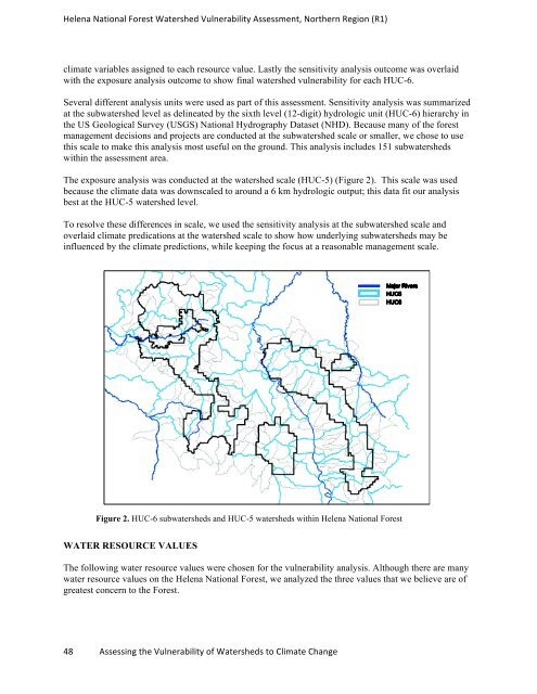
The exposure analysis was conducted at the watershed scale (HUC-5) (Figure 2). This scale was used<br />
because the climate data was downscaled to around a 6 km hydrologic output; this data fit our analysis<br />
best at the HUC-5 watershed level.<br />
To resolve these differences in scale, we used the sensitivity analysis at the subwatershed scale and<br />
overlaid climate predications at the watershed scale to show how underlying subwatersheds may be<br />
influenced by the climate predictions, while keeping the focus at a reasonable management scale.<br />
Figure 2. HUC-6 subwatersheds and HUC-5 watersheds within Helena National Forest<br />
WATER RESOURCE VALUES<br />
The following water resource values were chosen for the vulnerability analysis. Although there are many<br />
water resource values on the Helena National Forest, we analyzed the three values that we believe are of<br />
greatest concern to the Forest.<br />
48 Assessing the Vulnerability of Watersheds to Climate Change


