watervulnerability
watervulnerability watervulnerability
Gallatin National Forest Watershed Vulnerability Assessment, Northern Region (R1) Figure 6. Geophysical characterization of Gallatin National Forest subwatersheds. 38 Assessing the Vulnerability of Watersheds to Climate Change
Gallatin National Forest Watershed Vulnerability Assessment, Northern Region (R1) Watershed Condition Framework The second step in the WVA assessment is the WCF dataset. This dataset identifies the level of human disturbance on the landscape. All of the GNF subwatersheds analyzed through this process were determined to be either Functioning Properly or Functioning at Risk (Figure 7). Because of this determination, some of the potentially more important watersheds may have been de-emphasized and future runs will need to confirm and/or modify this as needed. Figure 7. Watershed Condition Framework for the Gallatin National Forest 39 Assessing the Vulnerability of Watersheds to Climate Change
- Page 2 and 3: AUTHORS AND CONTRIBUTORS Authors* M
- Page 4 and 5: ASSESSSING THE VULNERABILITY OF WAT
- Page 6 and 7: staff; the task group included repr
- Page 8 and 9: Figure 2. Conceptual model for asse
- Page 10 and 11: Figure 3. Density of springs and sm
- Page 12 and 13: Using Historic Data One finding con
- Page 14 and 15: NF (Region 8) relied on information
- Page 16 and 17: level of uncertainty. Though there
- Page 18 and 19: climate (Casola et al. 2005). Only
- Page 20 and 21: sensitivity. Most were derived from
- Page 22 and 23: The sensitivity evaluation typicall
- Page 24 and 25: in exposure. The result of combinin
- Page 26 and 27: highest priority for management act
- Page 28 and 29: to information affected the assessm
- Page 30 and 31: with and rely on in many resource d
- Page 32 and 33: Pilot National Forest Reports Conte
- Page 34 and 35: Assessment of Watershed Vulnerabili
- Page 36 and 37: Gallatin National Forest Watershed
- Page 38 and 39: Gallatin National Forest Watershed
- Page 40 and 41: Gallatin National Forest Watershed
- Page 44 and 45: Gallatin National Forest Watershed
- Page 46 and 47: Gallatin National Forest Watershed
- Page 48 and 49: Gallatin National Forest Watershed
- Page 50 and 51: Assessment of Watershed Vulnerabili
- Page 52 and 53: Helena National Forest Watershed Vu
- Page 54 and 55: Helena National Forest Watershed Vu
- Page 56 and 57: Helena National Forest Watershed Vu
- Page 58 and 59: Helena National Forest Watershed Vu
- Page 60 and 61: Helena National Forest Watershed Vu
- Page 62 and 63: Helena National Forest Watershed Vu
- Page 64 and 65: Helena National Forest Watershed Vu
- Page 66 and 67: Helena National Forest Watershed Vu
- Page 68 and 69: Assessment of Watershed Vulnerabili
- Page 70 and 71: Grand Mesa, Uncompahgre and Gunniso
- Page 72 and 73: Grand Mesa, Uncompahgre and Gunniso
- Page 74 and 75: Grand Mesa, Uncompahgre and Gunniso
- Page 76 and 77: Grand Mesa, Uncompahgre and Gunniso
- Page 78 and 79: Grand Mesa, Uncompahgre and Gunniso
- Page 80 and 81: Grand Mesa, Uncompahgre and Gunniso
- Page 82 and 83: Grand Mesa, Uncompahgre and Gunniso
- Page 84 and 85: Grand Mesa, Uncompahgre and Gunniso
- Page 86 and 87: Grand Mesa, Uncompahgre and Gunniso
- Page 88 and 89: Grand Mesa, Uncompahgre and Gunniso
- Page 90 and 91: Grand Mesa, Uncompahgre and Gunniso
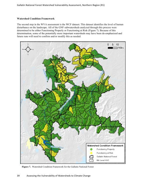
Gallatin National Forest Watershed Vulnerability Assessment, Northern Region (R1)<br />
Watershed Condition Framework<br />
The second step in the WVA assessment is the WCF dataset. This dataset identifies the level of human<br />
disturbance on the landscape. All of the GNF subwatersheds analyzed through this process were<br />
determined to be either Functioning Properly or Functioning at Risk (Figure 7). Because of this<br />
determination, some of the potentially more important watersheds may have been de-emphasized and<br />
future runs will need to confirm and/or modify this as needed.<br />
Figure 7. Watershed Condition Framework for the Gallatin National Forest<br />
39 Assessing the Vulnerability of Watersheds to Climate Change


