watervulnerability
watervulnerability watervulnerability
Chugach National Forest Watershed Vulnerability Assessment, Alaska Region (R10) assessment will stress the course of action that managers can take to mitigate the predicted negative effects. Realistically, there are a number of limitations on the analysis, particularly simple hydrologic data. Most of the Forest is accessible only by aircraft or boat, so data collection has generally been limited to projectspecific sites on a short-term basis. Since many of the watersheds have little historic or proposed human disturbance, data collection has not been a priority. I also assume that given the predicted climate changes for the area, undisturbed watersheds are best left alone. Predictions for coastal Alaska include increased precipitation, higher temperatures, and more intense storm events. While there may well be changes in stream flows, flow timing, or other effects, trying to “correct” those effects without altering other natural processes may be difficult. In addition, where there are no direct effects to infrastructure or threats to population centers, land managers may have higher priorities. Thus, instead of looking at all of the watersheds on the Forest and trying to rank their vulnerability, this assessment focuses on two of the more highly developed watersheds where more data are available, where a wider variety of restoration activity might occur, and that are representative of their ecological areas. These are the Eyak Lake watershed in a coastal rainforest ecosystem near Cordova, and the Resurrection Creek watershed in a relatively drier boreal forest setting on the Kenai Peninsula. Figure 1. The Chugach National Forest, its location in Alaska, and the two watersheds that were examined for this study Another limitation is that many of the biological effects are intuitively predictable – such as warmer water temperatures causing salmon eggs to develop and hatch sooner – but how these individual effects interact with other components of the ecosystem are unknown or cannot be quantified. Thus, there is a vast need for biological research that can help land managers reach decisions for on-the-ground mitigation activities. 270 Assessing the Vulnerability of Watersheds to Climate Change
Chugach National Forest Watershed Vulnerability Assessment, Alaska Region (R10) This assessment was made based on the conditions of the Chugach National Forest along the southcentral coast of Alaska, but it could be applicable to other areas in coastal Alaska, including southeast Alaska. The intent of focusing on just two watersheds is to have them serve as examples for land managers who may have watersheds with similar issues. METHODS The directions that participants in this pilot project were given included a number of practical steps. These included: • Describing the assessment areas, existing conditions, and the major water resources, or the waterrelated values or benefits in these areas. • Determining the anticipated climate change and its degree, using various predictive climate models. • Describing the predicted changes to hydrologic processes. • Determining the effects on water resources or values. • Describing the conditions that might amplify the changes and effects (stressors) or reduce them (buffers). • Determining the degree of watershed risk. • Describing how the findings might be applied to management activities at various geographic levels. The initial steps required consultations with area managers, literature searches (particularly of the gray literature), collecting historic temperature and precipitation data, and determining the availability of site specific data such as stream flows or water temperatures. The University of Alaska, Fairbanks (UAF), in collaboration with government agencies and nongovernmental organizations, conducts the Scenarios Network for Alaska Planning project (SNAP), which provides climate change data using a variety of Global Circulation Models (GCM) linked with historic Parameter-elevation Regressions on Independent Slope Models (PRISM) data. The resulting SNAP data can then make climate change predictions based on historic data that also take into account elevation, topographic facet, coastal proximity, slope, and distance from weather stations. This is particularly important in Alaska where there are large areas with few or no stations. There are ready-made maps with 2 km cells available online for temperature and precipitation, but the scale increments are somewhat coarse: 3 °C for temperatures close to freezing and 50 mm increments for precipitation. However, these maps are sufficient to determine overall trends and a rough estimate of the amount of change. Analysis requires downloading the data. For the initial efforts, UAF provided me with GIS layers of the Eyak Lake watershed where I could manipulate the scales to better detect freezing points and finer changes in precipitation. Since the elevations range from near sea level to 4,600 ft, the temperatures and precipitation vary significantly over short distances. The data were an average of the five GCM’s that best matched historical data. After the project was expanded to include Resurrection Creek, a GIS specialist for the Chugach National Forest downloaded and manipulated additional data available from SNAP for both watersheds. By using the raw data for each 2 km cell, the GIS specialist was able to average and obtain mean values for the watersheds as a whole. This was done for annual mean temperatures, annual mean precipitation, the freeze day, and the thaw day. The freeze and thaw days are extrapolated predictions of when the average 271 Assessing the Vulnerability of Watersheds to Climate Change
- Page 224 and 225: Umatilla National Forest Watershed
- Page 226 and 227: Umatilla National Forest Watershed
- Page 228 and 229: Umatilla National Forest Watershed
- Page 230 and 231: Assessment of Watershed Vulnerabili
- Page 232 and 233: Ouachita National Forest Watershed
- Page 234 and 235: Ouachita National Forest Watershed
- Page 236 and 237: Ouachita National Forest Watershed
- Page 238 and 239: Ouachita National Forest Watershed
- Page 240 and 241: Assessment of Watershed Vulnerabili
- Page 242 and 243: Chequamegon-‐Nicolet National F
- Page 244 and 245: Chequamegon-‐Nicolet National F
- Page 246 and 247: Chequamegon-‐Nicolet National F
- Page 248 and 249: Chequamegon-‐Nicolet National F
- Page 250 and 251: Chequamegon-‐Nicolet National F
- Page 252 and 253: Chequamegon-‐Nicolet National F
- Page 254 and 255: Chequamegon-‐Nicolet National F
- Page 256 and 257: Chequamegon-‐Nicolet National F
- Page 258 and 259: Chequamegon-‐Nicolet National F
- Page 260 and 261: Chequamegon-‐Nicolet National F
- Page 262 and 263: Chequamegon-‐Nicolet National F
- Page 264 and 265: Chequamegon-‐Nicolet National F
- Page 266 and 267: Chequamegon-‐Nicolet National F
- Page 268 and 269: Chequamegon-‐Nicolet National F
- Page 270 and 271: Assessment of Watershed Vulnerabili
- Page 272 and 273: Chugach National Forest Watershed V
- Page 276 and 277: Chugach National Forest Watershed V
- Page 278 and 279: Chugach National Forest Watershed V
- Page 280 and 281: Chugach National Forest Watershed V
- Page 282 and 283: Chugach National Forest Watershed V
- Page 284 and 285: Chugach National Forest Watershed V
- Page 286 and 287: Chugach National Forest Watershed V
- Page 288 and 289: Chugach National Forest Watershed V
- Page 290 and 291: Chugach National Forest Watershed V
- Page 292 and 293: Chugach National Forest Watershed V
- Page 294 and 295: Chugach National Forest Watershed V
- Page 296 and 297: Chugach National Forest Watershed V
- Page 298 and 299: Chugach National Forest Watershed V
- Page 300 and 301: Chugach National Forest Watershed V
- Page 302 and 303: Chugach National Forest Watershed V
- Page 304 and 305: Chugach National Forest Watershed V
- Page 306 and 307: Chugach National Forest Watershed V
- Page 308 and 309: Chugach National Forest Watershed V
Chugach National Forest Watershed Vulnerability Assessment, Alaska Region (R10)<br />
assessment will stress the course of action that managers can take to mitigate the predicted negative<br />
effects.<br />
Realistically, there are a number of limitations on the analysis, particularly simple hydrologic data. Most<br />
of the Forest is accessible only by aircraft or boat, so data collection has generally been limited to projectspecific<br />
sites on a short-term basis. Since many of the watersheds have little historic or proposed human<br />
disturbance, data collection has not been a priority.<br />
I also assume that given the predicted climate changes for the area, undisturbed watersheds are best left<br />
alone. Predictions for coastal Alaska include increased precipitation, higher temperatures, and more<br />
intense storm events. While there may well be changes in stream flows, flow timing, or other effects,<br />
trying to “correct” those effects without altering other natural processes may be difficult. In addition,<br />
where there are no direct effects to infrastructure or threats to population centers, land managers may<br />
have higher priorities.<br />
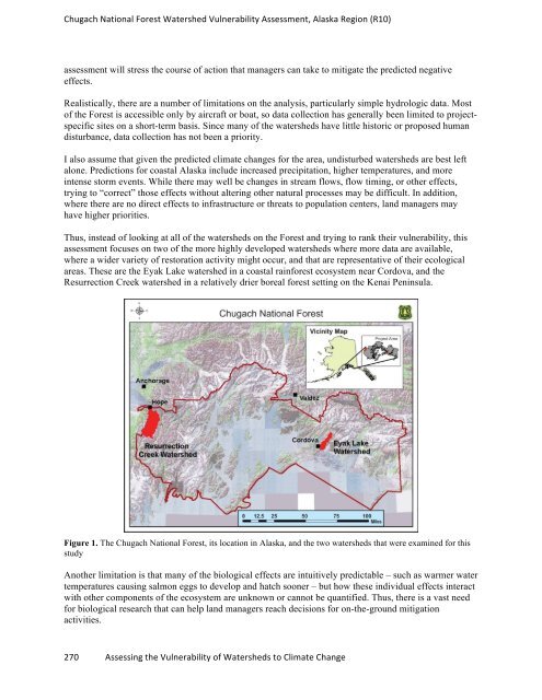
Thus, instead of looking at all of the watersheds on the Forest and trying to rank their vulnerability, this<br />
assessment focuses on two of the more highly developed watersheds where more data are available,<br />
where a wider variety of restoration activity might occur, and that are representative of their ecological<br />
areas. These are the Eyak Lake watershed in a coastal rainforest ecosystem near Cordova, and the<br />
Resurrection Creek watershed in a relatively drier boreal forest setting on the Kenai Peninsula.<br />
Figure 1. The Chugach National Forest, its location in Alaska, and the two watersheds that were examined for this<br />
study<br />
Another limitation is that many of the biological effects are intuitively predictable – such as warmer water<br />
temperatures causing salmon eggs to develop and hatch sooner – but how these individual effects interact<br />
with other components of the ecosystem are unknown or cannot be quantified. Thus, there is a vast need<br />
for biological research that can help land managers reach decisions for on-the-ground mitigation<br />
activities.<br />
270 Assessing the Vulnerability of Watersheds to Climate Change


