watervulnerability
watervulnerability watervulnerability
Chequamegon-‐Nicolet National Forest Watershed Vulnerability Assessment, Eastern Region (R9) Figure 18. Predicted vulnerability of 2 species of coldwater fish by 6th level watershed for moderate warming (3 deg C increase), for Chequamegon-Nicolet NF 258 Assessing the Vulnerability of Watersheds to Climate Change
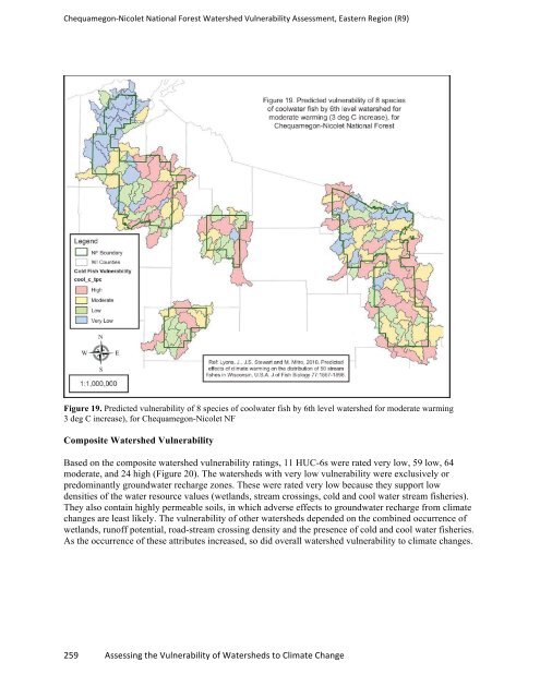
Chequamegon-‐Nicolet National Forest Watershed Vulnerability Assessment, Eastern Region (R9) Figure 19. Predicted vulnerability of 8 species of coolwater fish by 6th level watershed for moderate warming 3 deg C increase), for Chequamegon-Nicolet NF Composite Watershed Vulnerability Based on the composite watershed vulnerability ratings, 11 HUC-6s were rated very low, 59 low, 64 moderate, and 24 high (Figure 20). The watersheds with very low vulnerability were exclusively or predominantly groundwater recharge zones. These were rated very low because they support low densities of the water resource values (wetlands, stream crossings, cold and cool water stream fisheries). They also contain highly permeable soils, in which adverse effects to groundwater recharge from climate changes are least likely. The vulnerability of other watersheds depended on the combined occurrence of wetlands, runoff potential, road-stream crossing density and the presence of cold and cool water fisheries. As the occurrence of these attributes increased, so did overall watershed vulnerability to climate changes. 259 Assessing the Vulnerability of Watersheds to Climate Change
- Page 212 and 213: Shasta Trinity National Forest Wate
- Page 214 and 215: Assessment of Watershed Vulnerabili
- Page 216 and 217: Umatilla National Forest Watershed
- Page 218 and 219: Umatilla National Forest Watershed
- Page 220 and 221: Umatilla National Forest Watershed
- Page 222 and 223: Umatilla National Forest Watershed
- Page 224 and 225: Umatilla National Forest Watershed
- Page 226 and 227: Umatilla National Forest Watershed
- Page 228 and 229: Umatilla National Forest Watershed
- Page 230 and 231: Assessment of Watershed Vulnerabili
- Page 232 and 233: Ouachita National Forest Watershed
- Page 234 and 235: Ouachita National Forest Watershed
- Page 236 and 237: Ouachita National Forest Watershed
- Page 238 and 239: Ouachita National Forest Watershed
- Page 240 and 241: Assessment of Watershed Vulnerabili
- Page 242 and 243: Chequamegon-‐Nicolet National F
- Page 244 and 245: Chequamegon-‐Nicolet National F
- Page 246 and 247: Chequamegon-‐Nicolet National F
- Page 248 and 249: Chequamegon-‐Nicolet National F
- Page 250 and 251: Chequamegon-‐Nicolet National F
- Page 252 and 253: Chequamegon-‐Nicolet National F
- Page 254 and 255: Chequamegon-‐Nicolet National F
- Page 256 and 257: Chequamegon-‐Nicolet National F
- Page 258 and 259: Chequamegon-‐Nicolet National F
- Page 260 and 261: Chequamegon-‐Nicolet National F
- Page 264 and 265: Chequamegon-‐Nicolet National F
- Page 266 and 267: Chequamegon-‐Nicolet National F
- Page 268 and 269: Chequamegon-‐Nicolet National F
- Page 270 and 271: Assessment of Watershed Vulnerabili
- Page 272 and 273: Chugach National Forest Watershed V
- Page 274 and 275: Chugach National Forest Watershed V
- Page 276 and 277: Chugach National Forest Watershed V
- Page 278 and 279: Chugach National Forest Watershed V
- Page 280 and 281: Chugach National Forest Watershed V
- Page 282 and 283: Chugach National Forest Watershed V
- Page 284 and 285: Chugach National Forest Watershed V
- Page 286 and 287: Chugach National Forest Watershed V
- Page 288 and 289: Chugach National Forest Watershed V
- Page 290 and 291: Chugach National Forest Watershed V
- Page 292 and 293: Chugach National Forest Watershed V
- Page 294 and 295: Chugach National Forest Watershed V
- Page 296 and 297: Chugach National Forest Watershed V
- Page 298 and 299: Chugach National Forest Watershed V
- Page 300 and 301: Chugach National Forest Watershed V
- Page 302 and 303: Chugach National Forest Watershed V
- Page 304 and 305: Chugach National Forest Watershed V
- Page 306 and 307: Chugach National Forest Watershed V
- Page 308 and 309: Chugach National Forest Watershed V
Chequamegon-‐Nicolet National Forest Watershed Vulnerability Assessment, Eastern Region (R9)<br />
Figure 19. Predicted vulnerability of 8 species of coolwater fish by 6th level watershed for moderate warming<br />
3 deg C increase), for Chequamegon-Nicolet NF<br />
Composite Watershed Vulnerability<br />
Based on the composite watershed vulnerability ratings, 11 HUC-6s were rated very low, 59 low, 64<br />
moderate, and 24 high (Figure 20). The watersheds with very low vulnerability were exclusively or<br />
predominantly groundwater recharge zones. These were rated very low because they support low<br />
densities of the water resource values (wetlands, stream crossings, cold and cool water stream fisheries).<br />
They also contain highly permeable soils, in which adverse effects to groundwater recharge from climate<br />
changes are least likely. The vulnerability of other watersheds depended on the combined occurrence of<br />
wetlands, runoff potential, road-stream crossing density and the presence of cold and cool water fisheries.<br />
As the occurrence of these attributes increased, so did overall watershed vulnerability to climate changes.<br />
259 Assessing the Vulnerability of Watersheds to Climate Change


