watervulnerability
watervulnerability watervulnerability
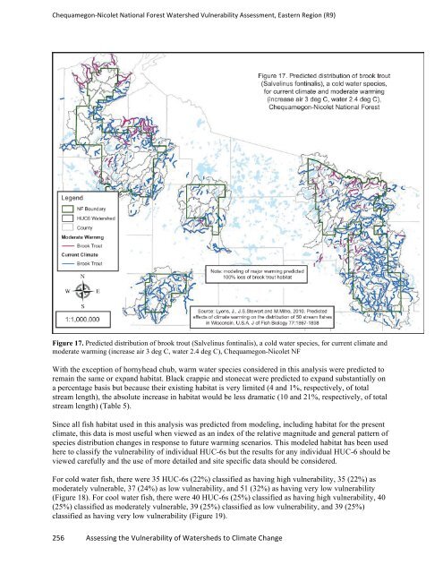
Chequamegon-‐Nicolet National Forest Watershed Vulnerability Assessment, Eastern Region (R9) Figure 17. Predicted distribution of brook trout (Salvelinus fontinalis), a cold water species, for current climate and moderate warming (increase air 3 deg C, water 2.4 deg C), Chequamegon-Nicolet NF With the exception of hornyhead chub, warm water species considered in this analysis were predicted to remain the same or expand habitat. Black crappie and stonecat were predicted to expand substantially on a percentage basis but because their existing habitat is very limited (4 and 1%, respectively, of total stream length), the absolute increase in habitat would be less dramatic (10 and 21%, respectively, of total stream length) (Table 5). Since all fish habitat used in this analysis was predicted from modeling, including habitat for the present climate, this data is most useful when viewed as an index of the relative magnitude and general pattern of species distribution changes in response to future warming scenarios. This modeled habitat has been used here to classify the vulnerability of individual HUC-6s but the results for any individual HUC-6 should be viewed carefully and the use of more detailed and site specific data should be considered. For cold water fish, there were 35 HUC-6s (22%) classified as having high vulnerability, 35 (22%) as moderately vulnerable, 37 (24%) as low vulnerability, and 51 (32%) as having very low vulnerability (Figure 18). For cool water fish, there were 40 HUC-6s (25%) classified as having high vulnerability, 40 (25%) classified as moderately vulnerable, 39 (25%) classified as low vulnerability, and 39 (25%) classified as having very low vulnerability (Figure 19). 256 Assessing the Vulnerability of Watersheds to Climate Change
Chequamegon-‐Nicolet National Forest Watershed Vulnerability Assessment, Eastern Region (R9) Fish Species brook trout (Salvelinus fontinalis) brown trout (Salmo trutta) mottled sculpin (Cottus bairdii) blacknose dace (Rhinichthys obtusus) brook stickleback (Culaea inconstans) creek chub (Semotilus atromaculatus) longnose dace (Rhinichthys cataractae) northern hogsucker (Hypentelium nigricans) northern redbelly dace (Phoxinus eos) Thermal Class Sensitivit y Class Size Class 257 Assessing the Vulnerability of Watersheds to Climate Change Climate Warming Scenarios Current Climate Limited Warming Moderate Warming Major Warming Length (km) % of Total Length Length (km) % Change % of Total Length Length (km) % Change % of Total Change Length (km) % Change cold S H 3122 50 2743 -12 44 603 -81 10 0 -100 0 cold S H 634 10 633 0 10 582 -8 9 289 -54 5 cold S H 4700 76 2983 -37 48 1137 -76 18 448 -90 7 cool T H 4927 79 4836 -2 78 1049 -79 17 613 -88 10 cool T H 2913 47 2906 0 47 2467 -15 40 1200 -59 19 cool T H 5244 85 4501 -14 73 1878 -64 30 1003 -81 16 cool S M 2051 33 2045 0 33 728 -65 12 126 -94 2 cool S R 1180 19 1143 -3 18 874 -26 14 183 -84 3 cool S H 4877 79 4594 -6 74 82 -98 1 0 -100 0 walleye (Sander vitreus) cool S R 289 5 283 -2 5 152 -47 2 0 -100 0 white sucker (Catostomus commersonii) cool T U 3164 51 2836 -10 46 711 -78 11 158 -95 3 black crappie (Pomoxis nigromaculatus) warm M R 222 4 534 141 9 1261 468 20 1261 468 20 hornyhead chub (Nocomis biguttatus) warm S M 3211 52 3192 -1 51 679 -79 11 760 -76 12 logperch (Percina caprodes) warm S R 1307 21 1159 -11 19 1086 -17 18 1407 8 23 smallmouth bass (Micropterus dolomieu) warm S R 613 10 613 0 10 613 0 10 613 0 10 stonecat (Noturus flavus) warm S M 55 1 334 507 5 590 973 10 633 1051 10 Table 5. Summary of predicted fish habitat under three warming scenarios for HUC6 watersheds encompassing the Chequamegon-Nicolet National Forest (for sensitivity: S=sensitive, M=moderate, T=tolerant; for size class: H=headwater, M=mainstem, R=riverine, U=ubiquitous; findings based on Lyons et al. 2010) % of Total Length
- Page 210 and 211: Shasta Trinity National Forest Wate
- Page 212 and 213: Shasta Trinity National Forest Wate
- Page 214 and 215: Assessment of Watershed Vulnerabili
- Page 216 and 217: Umatilla National Forest Watershed
- Page 218 and 219: Umatilla National Forest Watershed
- Page 220 and 221: Umatilla National Forest Watershed
- Page 222 and 223: Umatilla National Forest Watershed
- Page 224 and 225: Umatilla National Forest Watershed
- Page 226 and 227: Umatilla National Forest Watershed
- Page 228 and 229: Umatilla National Forest Watershed
- Page 230 and 231: Assessment of Watershed Vulnerabili
- Page 232 and 233: Ouachita National Forest Watershed
- Page 234 and 235: Ouachita National Forest Watershed
- Page 236 and 237: Ouachita National Forest Watershed
- Page 238 and 239: Ouachita National Forest Watershed
- Page 240 and 241: Assessment of Watershed Vulnerabili
- Page 242 and 243: Chequamegon-‐Nicolet National F
- Page 244 and 245: Chequamegon-‐Nicolet National F
- Page 246 and 247: Chequamegon-‐Nicolet National F
- Page 248 and 249: Chequamegon-‐Nicolet National F
- Page 250 and 251: Chequamegon-‐Nicolet National F
- Page 252 and 253: Chequamegon-‐Nicolet National F
- Page 254 and 255: Chequamegon-‐Nicolet National F
- Page 256 and 257: Chequamegon-‐Nicolet National F
- Page 258 and 259: Chequamegon-‐Nicolet National F
- Page 262 and 263: Chequamegon-‐Nicolet National F
- Page 264 and 265: Chequamegon-‐Nicolet National F
- Page 266 and 267: Chequamegon-‐Nicolet National F
- Page 268 and 269: Chequamegon-‐Nicolet National F
- Page 270 and 271: Assessment of Watershed Vulnerabili
- Page 272 and 273: Chugach National Forest Watershed V
- Page 274 and 275: Chugach National Forest Watershed V
- Page 276 and 277: Chugach National Forest Watershed V
- Page 278 and 279: Chugach National Forest Watershed V
- Page 280 and 281: Chugach National Forest Watershed V
- Page 282 and 283: Chugach National Forest Watershed V
- Page 284 and 285: Chugach National Forest Watershed V
- Page 286 and 287: Chugach National Forest Watershed V
- Page 288 and 289: Chugach National Forest Watershed V
- Page 290 and 291: Chugach National Forest Watershed V
- Page 292 and 293: Chugach National Forest Watershed V
- Page 294 and 295: Chugach National Forest Watershed V
- Page 296 and 297: Chugach National Forest Watershed V
- Page 298 and 299: Chugach National Forest Watershed V
- Page 300 and 301: Chugach National Forest Watershed V
- Page 302 and 303: Chugach National Forest Watershed V
- Page 304 and 305: Chugach National Forest Watershed V
- Page 306 and 307: Chugach National Forest Watershed V
- Page 308 and 309: Chugach National Forest Watershed V
Chequamegon-‐Nicolet National Forest Watershed Vulnerability Assessment, Eastern Region (R9)<br />
Figure 17. Predicted distribution of brook trout (Salvelinus fontinalis), a cold water species, for current climate and<br />
moderate warming (increase air 3 deg C, water 2.4 deg C), Chequamegon-Nicolet NF<br />
With the exception of hornyhead chub, warm water species considered in this analysis were predicted to<br />
remain the same or expand habitat. Black crappie and stonecat were predicted to expand substantially on<br />
a percentage basis but because their existing habitat is very limited (4 and 1%, respectively, of total<br />
stream length), the absolute increase in habitat would be less dramatic (10 and 21%, respectively, of total<br />
stream length) (Table 5).<br />
Since all fish habitat used in this analysis was predicted from modeling, including habitat for the present<br />
climate, this data is most useful when viewed as an index of the relative magnitude and general pattern of<br />
species distribution changes in response to future warming scenarios. This modeled habitat has been used<br />
here to classify the vulnerability of individual HUC-6s but the results for any individual HUC-6 should be<br />
viewed carefully and the use of more detailed and site specific data should be considered.<br />
For cold water fish, there were 35 HUC-6s (22%) classified as having high vulnerability, 35 (22%) as<br />
moderately vulnerable, 37 (24%) as low vulnerability, and 51 (32%) as having very low vulnerability<br />
(Figure 18). For cool water fish, there were 40 HUC-6s (25%) classified as having high vulnerability, 40<br />
(25%) classified as moderately vulnerable, 39 (25%) classified as low vulnerability, and 39 (25%)<br />
classified as having very low vulnerability (Figure 19).<br />
256 Assessing the Vulnerability of Watersheds to Climate Change


