watervulnerability
watervulnerability watervulnerability
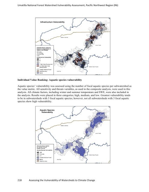
Umatilla National Forest Watershed Vulnerability Assessment, Pacific Northwest Region (R6) Individual Value Ranking: Aquatic species vulnerability Aquatic species’ vulnerability was assessed using the number of focal aquatic species per subwatershed as the value metric. All sensitivity and threats variables, as used in the composite analysis, were used in this analysis. All climate factors, including winter and summer temperature and SWE, were also included in the analysis. Results were placed in three categories; high, medium, and low. Greatest vulnerability tends to be in subwatersheds with 3 focal aquatic species; however, not all subwatersheds with 3 focal aquatic species show high vulnerability. 218 Assessing the Vulnerability of Watersheds to Climate Change
Umatilla National Forest Watershed Vulnerability Assessment, Pacific Northwest Region (R6) FINE SCALE ANALYSIS FOR BULL TROUT Bull trout (Salvelinus confluentus) was used as our aquatic focal species in the WVA because bull trout require cold (≤ 17 °C) and relatively low gradient, pristine waters to rear and spawn. They have a small thermal niche and are very responsive to changes in stream temperature. Analysis of suitable habitat on the UNF is necessary because bull trout are on the edge of their bioclimatic envelope (Beever et al. 2010, Dunham et al. 2003); the UNF is a fairly low elevation, dry forest landscape. Bull trout populations in the southern parts of the UNF can also be described as peripheral populations or species that are at the geographic edge of their range; they often have increased conservation value because they maximize within-species biodiversity, retain important evolutionary legacies, and may provide a “gene pool” for future adaptation (Haak et al. 2010). Previous research suggests future stream temperature increases on the forest, but influences on distribution and abundance of stream organisms is not well documented (Rieman et al. 2007). To begin the analysis, current bull trout distributions were identified in the Umatilla, Walla Walla, Tucannon, Lookingglass, and North Fork John Day (NFJD) drainages. Previous stream surveys conducted by USFS and ODFW/WDFW were used to verify current bull trout distribution. Multiple Regression Stream Temperature Model A multiple regression stream temperature model developed by the RMRS was used to model historic, current and future (years 2033, 2058, 2080) suitable bull trout habitat. Stream temperature model information and methods to the can be found at www.fs.fed.us/rm/boise/AWAE/projects/stream_temperature.shtml The regression model used observed mean weekly maximum temperature (MWMT) and physical parameters or predictor variables and geomorphic variables that have direct effects on stream temperatures. (The regression equation and coefficients can be found at www.fs.fed.us/ccrc/wva/appendixes.) Physical metrics: • Water diversion • Wildfire – Used data from the last 20 years; ~4km from the stream. • Groundwater Dependent Ecosystems (resiliency): number of springs and wetlands per HU12, rated Geomorphic variables or metrics (National hydrologic data set): • Cumulative drainage area (km 2 ) • Slope (%) • Elevation (m) Observed Stream Temperature and Climate Data Observed summer MWMT were taken from 37 locations and provided a total of 333 stream observations. A separate regression model was developed to predict historic and future stream temperatures using the same physical and geomorphic predictor vales, however, air MWMT data (1979-2009) and flow (m 3 /s) data (1957-2009) were considered. (Details about this regression model are available at www.fs.fed.us/ccrc/wva/appendixes.) 219 Assessing the Vulnerability of Watersheds to Climate Change
- Page 172 and 173: Sawtooth National Forest Watershed
- Page 174 and 175: Sawtooth National Forest Watershed
- Page 176 and 177: Sawtooth National Forest Watershed
- Page 178 and 179: Sawtooth National Forest Watershed
- Page 180 and 181: Sawtooth National Forest Watershed
- Page 182 and 183: Sawtooth National Forest Watershed
- Page 184 and 185: Sawtooth National Forest Watershed
- Page 186 and 187: Sawtooth National Forest Watershed
- Page 188 and 189: Sawtooth National Forest Watershed
- Page 190 and 191: Shasta Trinity National Forest Wate
- Page 192 and 193: Shasta Trinity National Forest Wate
- Page 194 and 195: Shasta Trinity National Forest Wate
- Page 196 and 197: Shasta Trinity National Forest Wate
- Page 198 and 199: Shasta Trinity National Forest Wate
- Page 200 and 201: Shasta Trinity National Forest Wate
- Page 202 and 203: Shasta Trinity National Forest Wate
- Page 204 and 205: Shasta Trinity National Forest Wate
- Page 206 and 207: Shasta Trinity National Forest Wate
- Page 208 and 209: Shasta Trinity National Forest Wate
- Page 210 and 211: Shasta Trinity National Forest Wate
- Page 212 and 213: Shasta Trinity National Forest Wate
- Page 214 and 215: Assessment of Watershed Vulnerabili
- Page 216 and 217: Umatilla National Forest Watershed
- Page 218 and 219: Umatilla National Forest Watershed
- Page 220 and 221: Umatilla National Forest Watershed
- Page 224 and 225: Umatilla National Forest Watershed
- Page 226 and 227: Umatilla National Forest Watershed
- Page 228 and 229: Umatilla National Forest Watershed
- Page 230 and 231: Assessment of Watershed Vulnerabili
- Page 232 and 233: Ouachita National Forest Watershed
- Page 234 and 235: Ouachita National Forest Watershed
- Page 236 and 237: Ouachita National Forest Watershed
- Page 238 and 239: Ouachita National Forest Watershed
- Page 240 and 241: Assessment of Watershed Vulnerabili
- Page 242 and 243: Chequamegon-‐Nicolet National F
- Page 244 and 245: Chequamegon-‐Nicolet National F
- Page 246 and 247: Chequamegon-‐Nicolet National F
- Page 248 and 249: Chequamegon-‐Nicolet National F
- Page 250 and 251: Chequamegon-‐Nicolet National F
- Page 252 and 253: Chequamegon-‐Nicolet National F
- Page 254 and 255: Chequamegon-‐Nicolet National F
- Page 256 and 257: Chequamegon-‐Nicolet National F
- Page 258 and 259: Chequamegon-‐Nicolet National F
- Page 260 and 261: Chequamegon-‐Nicolet National F
- Page 262 and 263: Chequamegon-‐Nicolet National F
- Page 264 and 265: Chequamegon-‐Nicolet National F
- Page 266 and 267: Chequamegon-‐Nicolet National F
- Page 268 and 269: Chequamegon-‐Nicolet National F
- Page 270 and 271: Assessment of Watershed Vulnerabili
Umatilla National Forest Watershed Vulnerability Assessment, Pacific Northwest Region (R6)<br />
Individual Value Ranking: Aquatic species vulnerability<br />
Aquatic species’ vulnerability was assessed using the number of focal aquatic species per subwatershed as<br />
the value metric. All sensitivity and threats variables, as used in the composite analysis, were used in this<br />
analysis. All climate factors, including winter and summer temperature and SWE, were also included in<br />
the analysis. Results were placed in three categories; high, medium, and low. Greatest vulnerability tends<br />
to be in subwatersheds with 3 focal aquatic species; however, not all subwatersheds with 3 focal aquatic<br />
species show high vulnerability.<br />
218 Assessing the Vulnerability of Watersheds to Climate Change


