watervulnerability
watervulnerability watervulnerability
Umatilla National Forest Watershed Vulnerability Assessment, Pacific Northwest Region (R6) OBJECTIVES AND SCALE OF ANALYSIS Forestwide “Coarse Grain” Analysis The objective is to produce a display for resource managers showing the relative vulnerability of Forest watersheds to risks posed by climate change, and identify watersheds containing water “values,” (systems) that may be susceptible to changes in hydrologic conditions (Hurd 1999; Furniss et al. 2010). The analysis framework was outlined by the WVA steering committee and 12 pilot Forests with the overall goal of producing case studies with examples and a framework for National Forest watershed vulnerability assessments. The analysis scale was Forestwide at the subwatershed unit (12-digit hydrologic unit, or HU12). A total of 162 HU12 watersheds contain UNF acres; of these, 101 have 25% or more UNF acres where data and results are most representative. This scale was intended to provide an overview of the Forest, to distinguish relative vulnerability from place to place based on water resource values and non-climate sensitivity (resilience, condition, threats). The climate data resolution was not detailed enough for HU12level analysis, so data were summarized at the HU10 (watershed) scale and applied uniformly to subwatersheds contained within. Generalized Framework Steps Values Sensitivity Exposure Vulnerability Response Water Uses, Infrastructure, Aquatics Base Watershed Condition ratings, Resiliency factors, Threats Historic and Projected Climate (2030 and 2070) Winter Temperature, Summer Temperature, and April 1 Snow water equivalent (SWE) Focused Watersheds or “Fine Grain” Analysis for Bull Trout 212 Assessing the Vulnerability of Watersheds to Climate Change Relative rating based on values, sensitivity, and exposure. Composite and individual value ratings Evaluate restoration priorities, infrastructure risk, community engagement Our goal was to develop an understanding of climate change specific to water temperatures and suitable critical bull trout (Salvelinus confluentus) habitat on a HU10 forestwide scale. The analysis was focused within HU12 subwatersheds in the three bull trout ESU subareas on the Umatilla NF (John Day, Tucannon in the Snake River and Washington recovery unit, and the Umatilla - Walla Walla recovery unit). The aim was to delineate historic, current, and future suitable bull trout habitat using a multiple regression stream temperature model developed by the RMRS. CONNECTION TO OTHER ASSESSMENTS Climate change vulnerability assessments are now a component of USDA’s Strategic Plan. Region 6 has begun a broad-scale vulnerability assessment for multiple resources, including water uses and aquatics. Revision of the Blue Mountains National Forest management plans is well underway and water resource and aquatics issues are important aspects of planning. The Draft Forest plan identifies climate change as a management challenge both broadly and specifically to water resources. Two Regional aquatics strategies (Aquatic Restoration Strategy, 2005, and Aquatic and Riparian Conservation Strategy, 2008) do not explicitly address climate change implications, although results from vulnerability assessments could be
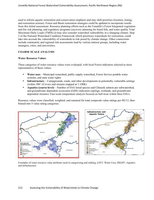
Umatilla National Forest Watershed Vulnerability Assessment, Pacific Northwest Region (R6) used to inform aquatic restoration and conservation emphasis and may shift priorities (location, timing, and restoration actions). Forest and Basin restoration strategies could be updated to incorporate results from this initial assessment. Resource planning efforts such as the Umatilla’s Forest Integrated vegetation and fire risk planning, and regulatory programs (recovery planning for listed fish, and water quality Total Maximum Daily Loads (TMDLs)) may also consider watershed vulnerability in a changing climate. Step 2 of the National Watershed Condition Framework which prioritizes watersheds for restoration, could take into account the vulnerability of watersheds to risk posed by climate change. Other connections include community and regional risk assessments lead by various interest groups, including water managers, cities, and universities. COARSE SCALE ANALYSIS Water Resource Values Three categories of water resource values were evaluated, with local Forest indicators selected as most representative of these values: • Water uses – Municipal watershed, public supply watershed, Forest Service potable water systems, and state water rights • Infrastructure – Campgrounds, roads, and other developments in potentially vulnerable settings (within 300’ of rivers and streams mapped at 1:100K) • Aquatics (coarse-level) – Number of ESA listed species and Chinook salmon per subwatershed, and groundwater dependent ecosystem (GDE) indicators (springs, wetlands, and groundwater dependent streams). Fine-scale temperature analysis focused on bull trout within three ESUs. Resource values were classified, weighted, and summed for total composite value ratings per HU12, then binned into 5 value rating categories. Examples of water resource value attributes used in categorizing and ranking, LEFT: Water Uses, RIGHT: Aquatics and Infrastructure 213 Assessing the Vulnerability of Watersheds to Climate Change
- Page 166 and 167: Sawtooth National Forest Watershed
- Page 168 and 169: Sawtooth National Forest Watershed
- Page 170 and 171: Sawtooth National Forest Watershed
- Page 172 and 173: Sawtooth National Forest Watershed
- Page 174 and 175: Sawtooth National Forest Watershed
- Page 176 and 177: Sawtooth National Forest Watershed
- Page 178 and 179: Sawtooth National Forest Watershed
- Page 180 and 181: Sawtooth National Forest Watershed
- Page 182 and 183: Sawtooth National Forest Watershed
- Page 184 and 185: Sawtooth National Forest Watershed
- Page 186 and 187: Sawtooth National Forest Watershed
- Page 188 and 189: Sawtooth National Forest Watershed
- Page 190 and 191: Shasta Trinity National Forest Wate
- Page 192 and 193: Shasta Trinity National Forest Wate
- Page 194 and 195: Shasta Trinity National Forest Wate
- Page 196 and 197: Shasta Trinity National Forest Wate
- Page 198 and 199: Shasta Trinity National Forest Wate
- Page 200 and 201: Shasta Trinity National Forest Wate
- Page 202 and 203: Shasta Trinity National Forest Wate
- Page 204 and 205: Shasta Trinity National Forest Wate
- Page 206 and 207: Shasta Trinity National Forest Wate
- Page 208 and 209: Shasta Trinity National Forest Wate
- Page 210 and 211: Shasta Trinity National Forest Wate
- Page 212 and 213: Shasta Trinity National Forest Wate
- Page 214 and 215: Assessment of Watershed Vulnerabili
- Page 218 and 219: Umatilla National Forest Watershed
- Page 220 and 221: Umatilla National Forest Watershed
- Page 222 and 223: Umatilla National Forest Watershed
- Page 224 and 225: Umatilla National Forest Watershed
- Page 226 and 227: Umatilla National Forest Watershed
- Page 228 and 229: Umatilla National Forest Watershed
- Page 230 and 231: Assessment of Watershed Vulnerabili
- Page 232 and 233: Ouachita National Forest Watershed
- Page 234 and 235: Ouachita National Forest Watershed
- Page 236 and 237: Ouachita National Forest Watershed
- Page 238 and 239: Ouachita National Forest Watershed
- Page 240 and 241: Assessment of Watershed Vulnerabili
- Page 242 and 243: Chequamegon-‐Nicolet National F
- Page 244 and 245: Chequamegon-‐Nicolet National F
- Page 246 and 247: Chequamegon-‐Nicolet National F
- Page 248 and 249: Chequamegon-‐Nicolet National F
- Page 250 and 251: Chequamegon-‐Nicolet National F
- Page 252 and 253: Chequamegon-‐Nicolet National F
- Page 254 and 255: Chequamegon-‐Nicolet National F
- Page 256 and 257: Chequamegon-‐Nicolet National F
- Page 258 and 259: Chequamegon-‐Nicolet National F
- Page 260 and 261: Chequamegon-‐Nicolet National F
- Page 262 and 263: Chequamegon-‐Nicolet National F
- Page 264 and 265: Chequamegon-‐Nicolet National F
Umatilla National Forest Watershed Vulnerability Assessment, Pacific Northwest Region (R6)<br />
used to inform aquatic restoration and conservation emphasis and may shift priorities (location, timing,<br />
and restoration actions). Forest and Basin restoration strategies could be updated to incorporate results<br />
from this initial assessment. Resource planning efforts such as the Umatilla’s Forest Integrated vegetation<br />
and fire risk planning, and regulatory programs (recovery planning for listed fish, and water quality Total<br />
Maximum Daily Loads (TMDLs)) may also consider watershed vulnerability in a changing climate. Step<br />
2 of the National Watershed Condition Framework which prioritizes watersheds for restoration, could<br />
take into account the vulnerability of watersheds to risk posed by climate change. Other connections<br />
include community and regional risk assessments lead by various interest groups, including water<br />
managers, cities, and universities.<br />
COARSE SCALE ANALYSIS<br />
Water Resource Values<br />
Three categories of water resource values were evaluated, with local Forest indicators selected as most<br />
representative of these values:<br />
• Water uses – Municipal watershed, public supply watershed, Forest Service potable water<br />
systems, and state water rights<br />
• Infrastructure – Campgrounds, roads, and other developments in potentially vulnerable settings<br />
(within 300’ of rivers and streams mapped at 1:100K)<br />
• Aquatics (coarse-level) – Number of ESA listed species and Chinook salmon per subwatershed,<br />
and groundwater dependent ecosystem (GDE) indicators (springs, wetlands, and groundwater<br />
dependent streams). Fine-scale temperature analysis focused on bull trout within three ESUs.<br />
Resource values were classified, weighted, and summed for total composite value ratings per HU12, then<br />
binned into 5 value rating categories.<br />
Examples of water resource value attributes used in categorizing and ranking, LEFT: Water Uses, RIGHT: Aquatics<br />
and Infrastructure<br />
213 Assessing the Vulnerability of Watersheds to Climate Change


