

watervulnerability
watervulnerability
watervulnerability

Create successful ePaper yourself
Turn your PDF publications into a flip-book with our unique Google optimized e-Paper software.
Sawtooth National Forest Watershed Vulnerability Assessment, Intermountain Region (R4)<br />
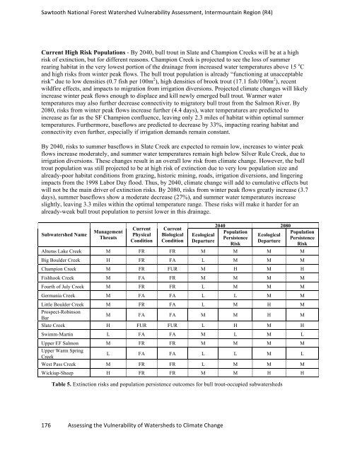
Current High Risk Populations - By 2040, bull trout in Slate and Champion Creeks will be at a high<br />
risk of extinction, but for different reasons. Champion Creek is projected to see the loss of summer<br />
rearing habitat in the very lowest portion of the drainage from increased water temperatures above 15 o C<br />
and high risks from winter peak flows. The bull trout population is already “functioning at unacceptable<br />
risk” due to low densities (0.7 fish per 100m 2 ), high densities of brook trout (17.1 fish/100m 2 ), recent<br />
wildfire effects, and impacts to migration from irrigation diversions. Projected climate changes will likely<br />
increase winter peak flows enough to displace and kill newly emerged bull trout. Warmer water<br />
temperatures may also further decrease connectivity to migratory bull trout from the Salmon River. By<br />
2080, risks from winter peak flows increase further (4.4 days), water temperatures are predicted to<br />
increase as far as the SF Champion confluence, leaving only 2.3 miles of habitat within optimal summer<br />
temperatures. Furthermore, baseflows are predicted to decrease by 33%, impacting rearing habitat and<br />
connectivity even further, especially if irrigation demands remain constant.<br />
By 2040, risks to summer baseflows in Slate Creek are expected to remain low, increases to winter peak<br />
flows increase moderately, and summer water temperatures remain high below Silver Rule Creek, due to<br />
irrigation diversions. These changes result in an overall low risk from climate change. However, the bull<br />
trout population was still projected to be at high risk of extinction due to very low population size and<br />
already-poor habitat conditions from grazing, historic mining, roads, irrigation diversions, and lingering<br />
impacts from the 1998 Labor Day flood. Thus, by 2040, climate change will add to cumulative effects but<br />
will not be the main driver of extinction risks. By 2080, risks from winter peak flows greatly increase (3.7<br />
days), summer baseflows show a moderate decrease (27%), and summer water temperatures increase<br />
slightly, leaving 3.3 miles within the optimal temperature range. These risks will make it harder for an<br />
already-weak bull trout population to persist lower in this drainage.<br />
Subwatershed Name Management<br />
Threats<br />
Current<br />
Physical<br />
Condition<br />
Current<br />
Biological<br />
Condition<br />
Ecological<br />
Departure<br />
176 Assessing the Vulnerability of Watersheds to Climate Change<br />
2040 2080<br />
Population<br />
Persistence<br />
Risk<br />
Ecological<br />
Departure<br />
Population<br />
Persistence<br />
Risk<br />
Alturas Lake Creek M FR FR M M M M<br />
Big Boulder Creek H FR FA L M M M<br />
Champion Creek M FR FUR M H M H<br />
Fishhook Creek M FA FR M M M M<br />
Fourth of July Creek M FR FR L M M M<br />
Germania Creek M FA FA L L M M<br />
Little Boulder Creek M FR FA L M H M<br />
Prospect-Robinson<br />
Bar<br />
M FA FA M M H M<br />
Slate Creek H FUR FUR L H M H<br />
Swimm-Martin L FA FA M L M L<br />
Upper EF Salmon M FR FR M M M M<br />
Upper Warm Spring<br />
Creek<br />
L FA FA L L M L<br />
West Pass Creek M FR FR L M M M<br />
Wickiup-Sheep H FR FR M M H H<br />
Table 5. Extinction risks and population persistence outcomes for bull trout-occupied subwatersheds