

watervulnerability
watervulnerability
watervulnerability

Create successful ePaper yourself
Turn your PDF publications into a flip-book with our unique Google optimized e-Paper software.
Sawtooth National Forest Watershed Vulnerability Assessment, Intermountain Region (R4)<br />
By 2080, only one (2.0%) subwatershed remains in a low risk category and three (5.9%) subwatersheds<br />
remain in a moderate risk category (Figure 9). The remaining 47 (92.1%) subwatersheds are in a high risk<br />
category, with Elk, Meadow, Pettit Lake, Smiley, Stanley Lake, and Upper Redfish Lake Creeks showing<br />
over a 5-day increase in winter peak flows.<br />
Summer Baseflows (Mean Summer)<br />
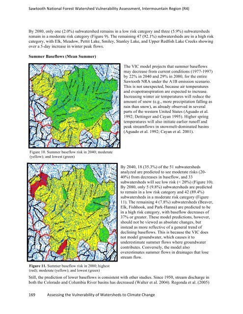
Figure 10. Summer baseflow risk in 2040; moderate<br />
(yellow); and lowest (green)<br />
169 Assessing the Vulnerability of Watersheds to Climate Change<br />
The VIC model projects that summer baseflows<br />
may decrease from current conditions (1977-1997)<br />
by 22% in 2040 and 29% in 2080, for the entire<br />
Sawtooth NRA under the A1B emission scenario.<br />
This is not unexpected, because air temperatures<br />
and evapotranspiration are expected to increase.<br />
Increasing winter air temperatures will reduce the<br />
amount of snow (e.g., more precipitation falling as<br />
rain than snow), as already observed in several<br />
parts of the western United States (Aguado et al.<br />
1992; Dettinger and Cayan 1995). Higher spring<br />
temperatures will also initiate earlier runoff and<br />
peak streamflows in snowmelt-dominated basins<br />
(Aguado et al. 1992; Cayan et al. 2001).<br />
By 2040, 18 (35.3%) of the 51 subwatersheds<br />
analyzed are predicted to see moderate risks (20-<br />
40%) from decreases in baseflow, and 33<br />
subwatersheds will see low risk (< 20%) (Figure 10).<br />
By 2080, only 5 (9.8%) subwatersheds are predicted<br />
to remain in a low risk category and 42 (89.4%)<br />
subwatersheds in a moderate risk category (Figure<br />
11). The remaining 4 (7.8%) subwatersheds (Beaver,<br />
Elk, Fishhook, and Park-Hanna) are predicted to be<br />
in a high risk category, with baseflow decreases of<br />
37% or greater. These model predictions, however,<br />
should not be viewed as absolute changes, but<br />
instead as more reflective of a general trend of<br />
declining baseflows. This is because the VIC does<br />
not model groundwater, which causes it to<br />
underestimate summer flows where groundwater<br />
contributes. Conversely, the model also<br />
overestimates summer flows in drainages that lose<br />
stream flow.<br />
Figure 11. Summer baseflow risk in 2080; highest<br />
(red); moderate (yellow); and lowest (green)<br />
Still, the prediction of lower baseflows is consistent with other studies. Since 1950, stream discharge in<br />
both the Colorado and Columbia River basins has decreased (Walter et al. 2004). Regonda et al. (2005)