

watervulnerability
watervulnerability
watervulnerability

Create successful ePaper yourself
Turn your PDF publications into a flip-book with our unique Google optimized e-Paper software.
Sawtooth National Forest Watershed Vulnerability Assessment, Intermountain Region (R4)<br />
were considered low risk, 20 to 40% were considered moderate, and greater than 40% were considered<br />
high risk. Changes in Winter 95 were determined by seeing how many days with the highest 5% flows<br />
increased from current to 2040 and 2080. Subwatersheds with less than a 0.5 day increase were<br />
considered low risk, 0.5 to 2 day increases were considered moderate risk, and increases greater than 2<br />
days were considered high risk. Risk ratings for Winter 95 and MeanSummer were provided by Seth<br />
Wenger, based on his recent work evaluating climate variables relative to geomorphic and land use in<br />
determining the distributions of bull trout and other species in the Interior Columbia River Basin (Wenger<br />
et al. (in press)).<br />
EXPOSURE RESULTS<br />
Winter Peak Flows (Winter 95) – The Upper Salmon<br />
subbasin has many high-elevation subwatersheds and<br />
is surrounded by 12,000-foot snow-capped peaks of<br />
the White Cloud and Sawtooth Mountains. Cold, dense<br />
air sinking from the mountains into the valley is the<br />
main reason for the chilly early-morning temperatures<br />
that are frequently the lowest in the lower 48 states. As<br />
a result, mid-winter rain-on-snow events are currently<br />
very rare. Rain-on-snow events that do occur typically<br />
happen in late April to May. The high elevation terrain<br />
and cold winter temperatures should help to buffer<br />
snow packs from winter flooding. However, as air<br />
temperatures increase, this natural buffering capacity<br />
will diminish, especially in those subwatersheds where<br />
temperatures hover around freezing. By 2100, air<br />
temperatures in Idaho could increase by 5°F (with a<br />
range of 2-9°F) in winter and summer (EPA 1998).<br />
The VIC model projects that the risk from mid-winter<br />
peak flows triggered by rain-on-snows events will<br />
increase by 2080. Specifically, the highest 5% winterpeak<br />
flows average 0.88 days under current conditions<br />
(1977-1997), but increase to 2.6 days in 2040 and to<br />
4.44 days in 2080 on the Sawtooth NRA under the<br />
A1B emission scenario. Wenger et al. (in press) found<br />
some areas in the interior Columbia River basin within<br />
the 1977-1997 timeframe to have up to 8.4 days at the<br />
highest 5% winter peak flow. Thus, the current risk of<br />
mid-winter peak flows is relatively low in comparison<br />
to other areas. However, these risks will be increasing.<br />
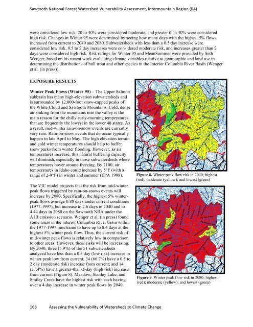
By 2040, three (5.9%) of the 51 subwatersheds<br />
analyzed have less than a 0.5 day (low risk) increase in<br />
winter peak low from current; 34 (66.7%) have a 0.5 to<br />
2 day (moderate risk) increase from current; and 14<br />
(27.4%) have a greater-than-2-day (high risk) increase<br />
from current (Figure 8). Meadow, Stanley Lake, and<br />
Smiley Creek have the highest risk with each having<br />
over a 4 day increase in winter peak flows by 2040.<br />
168 Assessing the Vulnerability of Watersheds to Climate Change<br />
Figure 8. Winter peak flow risk in 2040; highest<br />
(red); moderate (yellow); and lowest (green)<br />
Figure 9. Winter peak flow risk in 2080; highest<br />
(red); moderate (yellow); and lowest (green)