watervulnerability
watervulnerability watervulnerability
Coconino National Forest Watershed Vulnerability Assessment, Southwest Region (R3) Assessment of Watershed Vulnerability to Climate Change Sawtooth National Forest March, 2012 Prepared by: John Chatel Aquatics Program Manager Sawtooth National Forest Twin Falls Idaho 158 Assessing the Vulnerability of Watersheds to Climate Change
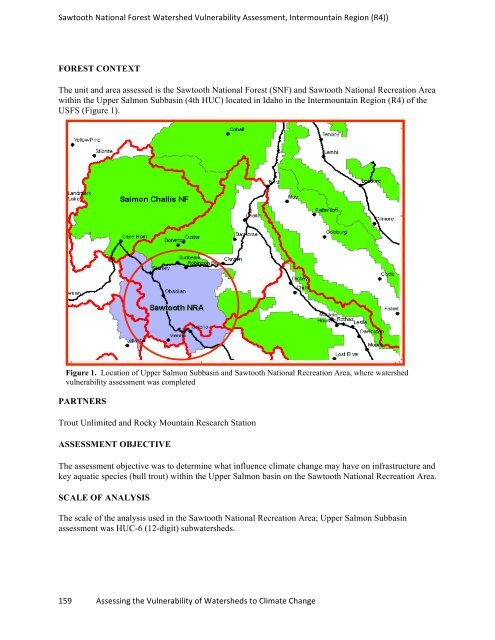
Sawtooth National Forest Watershed Vulnerability Assessment, Intermountain Region (R4)) FOREST CONTEXT The unit and area assessed is the Sawtooth National Forest (SNF) and Sawtooth National Recreation Area within the Upper Salmon Subbasin (4th HUC) located in Idaho in the Intermountain Region (R4) of the USFS (Figure 1). Figure 1. Location of Upper Salmon Subbasin and Sawtooth National Recreation Area, where watershed vulnerability assessment was completed PARTNERS Trout Unlimited and Rocky Mountain Research Station ASSESSMENT OBJECTIVE The assessment objective was to determine what influence climate change may have on infrastructure and key aquatic species (bull trout) within the Upper Salmon basin on the Sawtooth National Recreation Area. SCALE OF ANALYSIS The scale of the analysis used in the Sawtooth National Recreation Area; Upper Salmon Subbasin assessment was HUC-6 (12-digit) subwatersheds. 159 Assessing the Vulnerability of Watersheds to Climate Change
- Page 112 and 113: Grand Mesa, Uncompahgre and Gunniso
- Page 114 and 115: Grand Mesa, Uncompahgre and Gunniso
- Page 116 and 117: Assessment of Watershed Vulnerabili
- Page 118 and 119: White River National Forest Watersh
- Page 120 and 121: White River National Forest Watersh
- Page 122 and 123: White River National Forest Watersh
- Page 124 and 125: White River National Forest Watersh
- Page 126 and 127: White River National Forest Watersh
- Page 128 and 129: White River National Forest Watersh
- Page 130 and 131: White River National Forest Watersh
- Page 132 and 133: White River National Forest Watersh
- Page 134 and 135: Assessment of Watershed Vulnerabili
- Page 136 and 137: Coconino National Forest Watershed
- Page 138 and 139: Coconino National Forest Watershed
- Page 140 and 141: Coconino National Forest Watershed
- Page 142 and 143: Coconino National Forest Watershed
- Page 144 and 145: Coconino National Forest Watershed
- Page 146 and 147: Coconino National Forest Watershed
- Page 148 and 149: Coconino National Forest Watershed
- Page 150 and 151: Coconino National Forest Watershed
- Page 152 and 153: Coconino National Forest Watershed
- Page 154 and 155: Coconino National Forest Watershed
- Page 156 and 157: Coconino National Forest Watershed
- Page 158 and 159: Coconino National Forest Watershed
- Page 160 and 161: Coconino National Forest Watershed
- Page 164 and 165: Sawtooth National Forest Watershed
- Page 166 and 167: Sawtooth National Forest Watershed
- Page 168 and 169: Sawtooth National Forest Watershed
- Page 170 and 171: Sawtooth National Forest Watershed
- Page 172 and 173: Sawtooth National Forest Watershed
- Page 174 and 175: Sawtooth National Forest Watershed
- Page 176 and 177: Sawtooth National Forest Watershed
- Page 178 and 179: Sawtooth National Forest Watershed
- Page 180 and 181: Sawtooth National Forest Watershed
- Page 182 and 183: Sawtooth National Forest Watershed
- Page 184 and 185: Sawtooth National Forest Watershed
- Page 186 and 187: Sawtooth National Forest Watershed
- Page 188 and 189: Sawtooth National Forest Watershed
- Page 190 and 191: Shasta Trinity National Forest Wate
- Page 192 and 193: Shasta Trinity National Forest Wate
- Page 194 and 195: Shasta Trinity National Forest Wate
- Page 196 and 197: Shasta Trinity National Forest Wate
- Page 198 and 199: Shasta Trinity National Forest Wate
- Page 200 and 201: Shasta Trinity National Forest Wate
- Page 202 and 203: Shasta Trinity National Forest Wate
- Page 204 and 205: Shasta Trinity National Forest Wate
- Page 206 and 207: Shasta Trinity National Forest Wate
- Page 208 and 209: Shasta Trinity National Forest Wate
- Page 210 and 211: Shasta Trinity National Forest Wate
Sawtooth National Forest Watershed Vulnerability Assessment, Intermountain Region (R4))<br />
FOREST CONTEXT<br />
The unit and area assessed is the Sawtooth National Forest (SNF) and Sawtooth National Recreation Area<br />
within the Upper Salmon Subbasin (4th HUC) located in Idaho in the Intermountain Region (R4) of the<br />
USFS (Figure 1).<br />
Figure 1. Location of Upper Salmon Subbasin and Sawtooth National Recreation Area, where watershed<br />
vulnerability assessment was completed<br />
PARTNERS<br />
Trout Unlimited and Rocky Mountain Research Station<br />
ASSESSMENT OBJECTIVE<br />
The assessment objective was to determine what influence climate change may have on infrastructure and<br />
key aquatic species (bull trout) within the Upper Salmon basin on the Sawtooth National Recreation Area.<br />
SCALE OF ANALYSIS<br />
The scale of the analysis used in the Sawtooth National Recreation Area; Upper Salmon Subbasin<br />
assessment was HUC-6 (12-digit) subwatersheds.<br />
159 Assessing the Vulnerability of Watersheds to Climate Change


