watervulnerability
watervulnerability watervulnerability
Coconino National Forest Watershed Vulnerability Assessment, Southwest Region (R3) Figures 5 a-b. Location of selected herpetile and warm water fish species 136 Assessing the Vulnerability of Watersheds to Climate Change
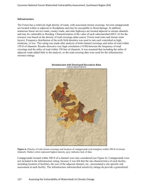
Coconino National Forest Watershed Vulnerability Assessment, Southwest Region (R3) Infrastructure The Forest has a relatively high density of roads, with associated stream crossings. Several campgrounds are located within or adjacent to floodplains and may be susceptible to flood damage. In addition, numerous forest service roads, county roads, and state highways are located adjacent to stream channels and may be vulnerable to flooding. Characterization of the value of each subwatershed (HUC-6) for the resource was based on the density of road crossings (data source: Forest road route and stream route layers). Frequency distribution of the sixth field densities was used to rate each watershed as high, moderate, or low. This rating was made after analysis of both channel crossings and miles of road within 150 ft of channels. Results showed a very high correlation (>0.90) between the frequency of road crossings and the miles of road within 150 feet of channels. It was assumed that including the miles of adjacent roads added little to the analysis, so the road crossing data were used for the infrastructure resource ratings. Figure 6. Density of road stream crossings and location of campgrounds (red triangles) within 300 ft of stream channels. Darker colors represent highest density; grey indicates lack of data. Campgrounds located within 300 ft of a channel were also considered (see Figure 6). Campgrounds were not included in the infrastructure rating, because it was felt that the site characteristics of each facility, including location of facilities, the size of the adjacent channel, etc., necessitated a site-specific risk assessment at each facility. The infrastructure subwatershed sensitivity ratings do provide a generalized, 137 Assessing the Vulnerability of Watersheds to Climate Change
- Page 90 and 91: Grand Mesa, Uncompahgre and Gunniso
- Page 92 and 93: Grand Mesa, Uncompahgre and Gunniso
- Page 94 and 95: Grand Mesa, Uncompahgre and Gunniso
- Page 96 and 97: Grand Mesa, Uncompahgre and Gunniso
- Page 98 and 99: Grand Mesa, Uncompahgre and Gunniso
- Page 100 and 101: Grand Mesa, Uncompahgre and Gunniso
- Page 102 and 103: Grand Mesa, Uncompahgre and Gunniso
- Page 104 and 105: Grand Mesa, Uncompahgre and Gunniso
- Page 106 and 107: Grand Mesa, Uncompahgre and Gunniso
- Page 108 and 109: Grand Mesa, Uncompahgre and Gunniso
- Page 110 and 111: Grand Mesa, Uncompahgre and Gunniso
- Page 112 and 113: Grand Mesa, Uncompahgre and Gunniso
- Page 114 and 115: Grand Mesa, Uncompahgre and Gunniso
- Page 116 and 117: Assessment of Watershed Vulnerabili
- Page 118 and 119: White River National Forest Watersh
- Page 120 and 121: White River National Forest Watersh
- Page 122 and 123: White River National Forest Watersh
- Page 124 and 125: White River National Forest Watersh
- Page 126 and 127: White River National Forest Watersh
- Page 128 and 129: White River National Forest Watersh
- Page 130 and 131: White River National Forest Watersh
- Page 132 and 133: White River National Forest Watersh
- Page 134 and 135: Assessment of Watershed Vulnerabili
- Page 136 and 137: Coconino National Forest Watershed
- Page 138 and 139: Coconino National Forest Watershed
- Page 142 and 143: Coconino National Forest Watershed
- Page 144 and 145: Coconino National Forest Watershed
- Page 146 and 147: Coconino National Forest Watershed
- Page 148 and 149: Coconino National Forest Watershed
- Page 150 and 151: Coconino National Forest Watershed
- Page 152 and 153: Coconino National Forest Watershed
- Page 154 and 155: Coconino National Forest Watershed
- Page 156 and 157: Coconino National Forest Watershed
- Page 158 and 159: Coconino National Forest Watershed
- Page 160 and 161: Coconino National Forest Watershed
- Page 162 and 163: Coconino National Forest Watershed
- Page 164 and 165: Sawtooth National Forest Watershed
- Page 166 and 167: Sawtooth National Forest Watershed
- Page 168 and 169: Sawtooth National Forest Watershed
- Page 170 and 171: Sawtooth National Forest Watershed
- Page 172 and 173: Sawtooth National Forest Watershed
- Page 174 and 175: Sawtooth National Forest Watershed
- Page 176 and 177: Sawtooth National Forest Watershed
- Page 178 and 179: Sawtooth National Forest Watershed
- Page 180 and 181: Sawtooth National Forest Watershed
- Page 182 and 183: Sawtooth National Forest Watershed
- Page 184 and 185: Sawtooth National Forest Watershed
- Page 186 and 187: Sawtooth National Forest Watershed
- Page 188 and 189: Sawtooth National Forest Watershed
Coconino National Forest Watershed Vulnerability Assessment, Southwest Region (R3)<br />
Infrastructure<br />
The Forest has a relatively high density of roads, with associated stream crossings. Several campgrounds<br />
are located within or adjacent to floodplains and may be susceptible to flood damage. In addition,<br />
numerous forest service roads, county roads, and state highways are located adjacent to stream channels<br />
and may be vulnerable to flooding. Characterization of the value of each subwatershed (HUC-6) for the<br />
resource was based on the density of road crossings (data source: Forest road route and stream route<br />
layers). Frequency distribution of the sixth field densities was used to rate each watershed as high,<br />
moderate, or low. This rating was made after analysis of both channel crossings and miles of road within<br />
150 ft of channels. Results showed a very high correlation (>0.90) between the frequency of road<br />
crossings and the miles of road within 150 feet of channels. It was assumed that including the miles of<br />
adjacent roads added little to the analysis, so the road crossing data were used for the infrastructure<br />
resource ratings.<br />
Figure 6. Density of road stream crossings and location of campgrounds (red triangles) within 300 ft of stream<br />
channels. Darker colors represent highest density; grey indicates lack of data.<br />
Campgrounds located within 300 ft of a channel were also considered (see Figure 6). Campgrounds were<br />
not included in the infrastructure rating, because it was felt that the site characteristics of each facility,<br />
including location of facilities, the size of the adjacent channel, etc., necessitated a site-specific risk<br />
assessment at each facility. The infrastructure subwatershed sensitivity ratings do provide a generalized,<br />
137 Assessing the Vulnerability of Watersheds to Climate Change


