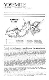
Restoring a Bridge to the Past - Yosemite Online
Restoring a Bridge to the Past - Yosemite Online
Restoring a Bridge to the Past - Yosemite Online

You also want an ePaper? Increase the reach of your titles
YUMPU automatically turns print PDFs into web optimized ePapers that Google loves.
im has important consequences for <strong>the</strong> scenery.<br />
From its terminus at Bridalveil Meadow, <strong>the</strong> ice surface<br />
of <strong>the</strong> Tioga Glacier would have sloped upward<br />
<strong>to</strong>ward <strong>the</strong> east end of <strong>Yosemite</strong> Valley, with <strong>the</strong> ice<br />
reaching a thickness of perhaps about 1,000 feet at<br />
Columbia Rock west of <strong>Yosemite</strong> Falls, 1,500 feet at<br />
Washing<strong>to</strong>n Column, and 2,000 feet in Tenaya Canyon<br />
below Basket Dome. Thus <strong>the</strong> Tioga and similar Tahoe<br />
glaciers could do very little <strong>to</strong> fur<strong>the</strong>r modify or smooth<br />
<strong>the</strong> upper walls of <strong>Yosemite</strong> Valley.<br />
Above <strong>the</strong> ice surface of those glaciers, <strong>the</strong> valley walls<br />
have had a million years <strong>to</strong> be affected by <strong>the</strong> wea<strong>the</strong>r;<br />
joints have widened, rock has fractured and crumbled,<br />
and waterfalls and cascades have eroded alcoves and<br />
ravines. Thus, <strong>the</strong> pinnacles and spires that seem so<br />
anomalous for a glacial valley have had about a million<br />
years <strong>to</strong> form above <strong>the</strong> level of later glaciers, and so<br />
remain <strong>to</strong> amaze us <strong>to</strong>day.<br />
Meanwhile, back in Tenaya Canyon, <strong>the</strong> Tioga ice was<br />
closer <strong>to</strong> its source and thicker, rasping higher up on <strong>the</strong><br />
valley walls and <strong>the</strong>reby smoothing <strong>the</strong>m and removing<br />
irregularities so that no pinnacles or spires are found <strong>the</strong>re.<br />
Having ascribed <strong>the</strong> different geomorphic aspects<br />
of <strong>the</strong> two valleys <strong>to</strong> <strong>the</strong>ir different glacial his<strong>to</strong>ries, <strong>the</strong><br />
next question is why those his<strong>to</strong>ries differ so. It was<br />
noted that <strong>the</strong> Tioga glaciation was much less extensive<br />
than <strong>the</strong> Sherwin glaciation that profoundly modified<br />
both valleys. The greater extent of <strong>the</strong> Tioga glacier in<br />
Hetch Hetchy, however, can be attributed <strong>to</strong> <strong>the</strong> fact that<br />
8<br />
Y O S E M I T E A S S O C I A T I O N , F A L L 2 0 0 4<br />
FIGURE 3. Comparison<br />
of Tioga-age glaciers<br />
in Hetch Hetchy and<br />
<strong>Yosemite</strong> Valleys. In left<br />
diagram, Hetch Hetchy<br />
Valley lies beneath glacial<br />
ice from about <strong>the</strong> 6400foot<br />
<strong>to</strong> 7200-foot ice-surface<br />
elevation con<strong>to</strong>urs. In<br />
right diagram, glacial ice<br />
in <strong>Yosemite</strong> Valley reaches<br />
only as far as Bridalveil<br />
Meadow. Note that <strong>the</strong><br />
ice <strong>to</strong>ngue down <strong>Yosemite</strong><br />
Creek (middle left) s<strong>to</strong>ps<br />
short of valley rim. 4<br />
<strong>the</strong> drainage basin, or snowfall-catchment area, of <strong>the</strong><br />
Tuolumne River system above Hetch Hetchy is more<br />
than three times as extensive as that of <strong>the</strong> Merced River<br />
above <strong>Yosemite</strong> Valley (figure 4).<br />
As a result, <strong>the</strong> much larger icefield feeding <strong>the</strong><br />
Tuolumne glacier was able <strong>to</strong> provide <strong>the</strong> volume of ice<br />
necessary <strong>to</strong> fill Hetch Hetchy Valley even though <strong>the</strong><br />
Tioga glaciation was regionally less extensive than <strong>the</strong><br />
Sherwin. This ice was delivered <strong>to</strong> Hetch Hetchy Valley,<br />
both down <strong>the</strong> main trunk of <strong>the</strong> Tuolumne River, and by<br />
tributaries entering <strong>the</strong> valley from <strong>the</strong> north that were<br />
fed from <strong>the</strong> nor<strong>the</strong>astern part of <strong>the</strong> Tuolumne icefield.<br />
This tremendous influx of ice is what helped “clean<br />
out” Hetch Hetchy Valley. The smaller Merced River icefield<br />
was unable <strong>to</strong> provide sufficient ice <strong>to</strong> fill <strong>Yosemite</strong><br />
Valley during <strong>the</strong> Tioga glaciation, even though supplemented<br />
by ice from <strong>the</strong> Tuolumne glacier that flowed<br />
southwest over several low passes in <strong>the</strong> Ca<strong>the</strong>dral Range<br />
(figure 3), and over one from Tuolumne Meadows in<strong>to</strong><br />
Tenaya Canyon.<br />
Having noted <strong>the</strong> significant differences between <strong>the</strong><br />
two valleys, and having attempted <strong>to</strong> explain <strong>the</strong> why<br />
and wherefore of those differences, our tale cannot end<br />
without considering some of <strong>the</strong>ir consequences, especially<br />
with respect <strong>to</strong> <strong>Yosemite</strong> Valley itself. The Tiogaage<br />
glacier did little <strong>to</strong> fur<strong>the</strong>r modify <strong>Yosemite</strong> Valley<br />
o<strong>the</strong>r than <strong>to</strong> remove fractured rock from <strong>the</strong> lower<br />
valley walls that had wea<strong>the</strong>red and loosened since <strong>the</strong><br />
previous glaciation. It also removed talus from <strong>the</strong> base
![(March 1982) [PDF] “We Are Pleased to Announce†- Yosemite Online](https://img.yumpu.com/51299748/1/190x242/march-1982-pdf-aeuroewe-are-pleased-to-announceaeur-yosemite-online.jpg?quality=85)
![[PDF] Old Horny, Yosemite's Unicorn Buck - Yosemite Online](https://img.yumpu.com/51269869/1/184x260/pdf-old-horny-yosemites-unicorn-buck-yosemite-online.jpg?quality=85)
![1985 [PDF] - Yosemite](https://img.yumpu.com/48128837/1/184x260/1985-pdf-yosemite.jpg?quality=85)