Winter Weather Watch/Warning/Advisory Procedures, and - NOAA
Winter Weather Watch/Warning/Advisory Procedures, and - NOAA
Winter Weather Watch/Warning/Advisory Procedures, and - NOAA

Create successful ePaper yourself
Turn your PDF publications into a flip-book with our unique Google optimized e-Paper software.
1<br />
NWS ERS 02-2003 NOVEMBER 1, 2012<br />
Department of Commerce • National Oceanic & Atmospheric Administration • National <strong>Weather</strong> Service<br />
NATIONAL WEATHER SERVICE EASTERN REGION SUPPLEMENT 02-2003<br />
APPLICABLE TO NWSI 10-513<br />
November 1, 2012<br />
Operations <strong>and</strong> Services<br />
Public <strong>Weather</strong> Services, NWSPD 10-5<br />
WFO <strong>Winter</strong> <strong>Weather</strong> Products Specification, NWSI 10-513<br />
WINTER WEATHER WATCH/WARNING/ADVISORY PROCEDURES AND<br />
THRESHOLDS<br />
NOTICE: This publication is available at: http://www.nws.noaa.gov/directives/<br />
OPR: W/ER1x6 (R.Watling) Certified by: W/ER1 (J. Guiney)<br />
Type of Issuance: Routine<br />
SUMMARY OF REVISIONS: This Supplement updates ERS 02-2003, “<strong>Winter</strong> <strong>Weather</strong><br />
<strong>Watch</strong>/<strong>Warning</strong>/<strong>Advisory</strong> Policy, <strong>Procedures</strong>, <strong>and</strong> Thresholds,” dated November 4, 2008, issued<br />
with NWSI 10-513, <strong>and</strong> contains the following revisions:<br />
1. Section 4.2 deletes mention of the Coded Cities Forecast.<br />
2. Section 4.2 adds an optional method of h<strong>and</strong>ling cold waves lasting two or more days.<br />
This section also eliminates time windows for WWA issuances <strong>and</strong> updates triggering<br />
methodology.<br />
3. Section 4.3 has been updated to eliminate mention of headline changes that have now<br />
been in effect for over three years.<br />
4. Section 4.4 has been updated to include mention of the bulleted warning format.<br />
5. Section 4.5 gives recommendations on bullet order.<br />
6. Section 4.6 contains new guidance on the use of LSRs in reporting winter weather.<br />
< Signed > October 19, 2012<br />
Mickey J. Brown Date<br />
Acting Director, NWS Eastern Region
2<br />
NWS ERS 02-2003 NOVEMBER 1, 2012<br />
Table of Contents: Page<br />
1. Purpose………………………………………………….………………………….....… 3<br />
2. Background……………………………………………..………………………………. 3<br />
3. Policy…………………………………………………………...………………………..<br />
4. Issuance <strong>Procedures</strong><br />
3<br />
4.1 Software………………………………………………………………… 3<br />
4.2 Trigger <strong>Procedures</strong>……...……………………………………………… 3<br />
4.3 Authorized Headlines…...……………………………………………… 4<br />
4.4 Content of Segments……………………………………………………. 4<br />
4.5 Recommended Order of Bullets…….………….………………….…… 5<br />
4.6 Reporting Storm Events…..……………………………………….…... 5<br />
4.7 Local Issuance<br />
5<br />
Delays…………………………………………………...<br />
4.8 NWS Attribution……………………...………………………………... 6<br />
4.9 <strong>Winter</strong> <strong>Weather</strong> in Outlooks……………..……………………………... 6<br />
4.10 Best Practices...…………..…...………………………………………... 6<br />
5. Criteria………………………………………………………………………………..….. 6
3<br />
NWS ERS 02-2003 NOVEMBER 1, 2012<br />
1) Purpose. The purpose of this Supplement is to document Eastern Region (ER) procedures<br />
for winter weather products in addition to the guidelines set forth in NWS Instruction 10-513<br />
WFO <strong>Winter</strong> <strong>Weather</strong> Product Specification.<br />
2) Background. <strong>Winter</strong> weather product inconsistencies between offices cause confusion <strong>and</strong><br />
diminished customer confidence. In addition, widespread use of computer graphics makes<br />
spatial/temporal inconsistencies very noticeable.<br />
3) Policy. To maximize product utility, ER field offices must strive to issue externally<br />
consistent watch, warning <strong>and</strong> advisory (WWA) products. To accomplish this goal,<br />
forecasters must underst<strong>and</strong> issuance thresholds, use the same interpretation of these<br />
thresholds, <strong>and</strong> collaborate with adjacent offices on hazard type, timing, <strong>and</strong> magnitude.<br />
Collaboration of forecasts delivers more consistent products <strong>and</strong> yields more accurate<br />
forecasts.<br />
4) Issuance <strong>Procedures</strong>.<br />
4.1 Software. All ER offices will use the latest nationally approved software, as<br />
the primary issuance tool for all winter weather watch/warning/advisory products.<br />
ECLAIRS will be used by ER offices to database winter storm reports.<br />
4.2 Triggering <strong>Procedures</strong>. The potential for a winter warning event will be<br />
mentioned in the Hazardous <strong>Weather</strong> Outlook (HWO) when there is a 30% chance or<br />
greater of meeting/exceeding warning criteria. <strong>Watch</strong>es are recommended when<br />
there is a 50% or greater chance of meeting/exceeding warning criteria; warnings are<br />
recommended when there is an 80% or greater chance of meeting/exceeding warning<br />
criteria. In rare situations when the uncertainty of meeting warning criteria is still<br />
around 50% within 12 hours of storm onset, forecasters should issue a warning or<br />
advisory to end the indecision.<br />
<strong>Winter</strong> precipitation forecasts (including hazards grids) must be included in the first<br />
48 hours of the forecast database <strong>and</strong> ideally go out further in time to ensure national<br />
requirements are met. Snowfall <strong>and</strong> ice accretion forecasts contained in text products<br />
such as the Zone Forecast Product, Area Forecast Matrices (AFM) <strong>and</strong> Point<br />
Forecast Matrices (PFM) will be consistent with amounts provided in the local<br />
database. Snowfall forecast data are not to be included in the State Forecast Tabular<br />
(SFT).<br />
The primary criterion for WWA issuance is snow/ice grid values meeting or<br />
exceeding warning/advisory thresholds across half or more of a zone. The impact of<br />
the event due to duration, timing <strong>and</strong> rates of snow accumulation/ice accretion should<br />
also be considered when determining the need for a WWA (e.g., high precipitation<br />
rate during a rush hour, first event of season, or long-duration event with high<br />
impact).
4<br />
NWS ERS 02-2003 NOVEMBER 1, 2012<br />
WWAs may be issued based on public impact alone. For example, if a storm is not<br />
expected to reach warning criteria, but heavy, wet snow, or a mixture of snow,<br />
freezing rain <strong>and</strong> ice pellets will significantly affect rush hour or transportation,<br />
commerce or electrical power service, a warning headline can be used. This rule<br />
applies especially during early <strong>and</strong> late season storms, <strong>and</strong> in locations where winter<br />
weather is rare. <strong>Winter</strong> <strong>Weather</strong> Advisories may also be issued for black ice<br />
conditions, when significant impact is expected.<br />
Wind Chill (WC) products are issued for apparent temperatures meeting or<br />
surpassing WC criteria when wind speeds are 6 mph or greater. If significant<br />
ambient cold temperatures occur with wind speeds 5 mph or less, WFOs may issue<br />
Special <strong>Weather</strong> Statements (SPS) highlighting the conditions <strong>and</strong> impacts.<br />
At WFO discretion, periods of extended cold temperature may be addressed via SPS<br />
just prior to <strong>and</strong> during cold snaps. Empirical data suggests that when the average<br />
daily temperature is 12°F or more below normal mid-January average daily<br />
temperatures, for 48 hours or longer, significant infrastructure impacts begin to<br />
occur. Significant impacts may include frozen water pipes <strong>and</strong> frozen fire sprinkler<br />
system piping, especially during holidays <strong>and</strong> long weekends in northern locations,<br />
<strong>and</strong> warrant extra caution by emergency managers, fire departments, building<br />
managers, <strong>and</strong> the public at-large.<br />
Release of winter storm products <strong>and</strong> their updates should be coordinated with<br />
surrounding WFOs to ensure consistency of information.<br />
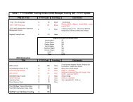
4.3 Authorized Headlines. Table 1 shows authorized winter weather headlines in<br />
WSW segments for ER offices.<br />
Table 1. Authorized ER winter weather headlines for WSW segments.<br />
HEADLINE TYPE WATCH WARNING ADVISORY<br />
Blizzard X X<br />
<strong>Winter</strong> Storm X X<br />
Lake Effect X X X<br />
Ice Storm X<br />
Freezing Rain X<br />
<strong>Winter</strong> <strong>Weather</strong> X<br />
Wind Chill<br />
.<br />
X X X<br />
4.4 Content of Segments. The four basic segment types (cancellation, warning,<br />
advisory or watch) may be subdivided into as many zone groupings as needed to<br />
address differing precipitation types or amounts across the forecast area. For<br />
cancellation segments, a UGC expiration time of one hour will be used. Forecasters<br />
must keep each segment’s text brief <strong>and</strong> to the point. Short bullets of one or two<br />
sentences, describing the phenomena, quantitative magnitude, timing, impacts,<br />
precautions, etc. will be used to present critical information.
5<br />
NWS ERS 02-2003 NOVEMBER 1, 2012<br />
Localized extreme snowfall values should not be mentioned, as most people will<br />
not observe the extremes. References <strong>and</strong>/or comparison to historical events will be<br />
reserved for warning situations <strong>and</strong> should only be mentioned if confidence is high<br />
that a comparable event is unfolding.<br />
4.5 Recommended Bullet Order. Bullets should be ordered with the highest<br />
impact element first then others listed in descending order of importance. Most<br />
frequently this will be snow/ice amounts first then timing of the start/end of<br />
precipitation, temperatures, wind velocity, expected impacts, safety precautions, etc.<br />
Other orderings are permissible, always based on the hierarchy of impacts.<br />
4.6 Reporting Storm Events. Public Information Statements (PNSs) will be the<br />
primary public product to report/summarize the latest winter precipitation, high wind<br />
observations or wind chill values to the public during winter weather events <strong>and</strong> will<br />
follow the format shown in resource links (see Section 5). A disclaimer must be<br />
appended to the PNS noting that information within the PNS is UNOFFICIAL.<br />
PNSs should be issued every three hours during an event. WFOs should also produce<br />
a summary PNS at the end of an event. Observations <strong>and</strong> related reports are<br />
permitted in other products to support warning or advisory content.<br />
Issuance of Local Storm Reports (LSRs) for winter phenomena are allowed <strong>and</strong><br />
encouraged, especially for fast-breaking, short-fused situations such as freezing rain<br />
episodes or high snow accumulation rates, when public impacts are the greatest.<br />
Any non-zero snow, sleet or ice accumulation observations will be entered into the<br />
Eastern Region Hydromet Database via ECLAIRS. This can be accomplished in two<br />
ways:<br />
1) Via transmission of a PNS using ECLAIRS, which will send the reports to<br />
Hydromet automatically,<br />
2) Via a comm<strong>and</strong> in the LSR/PNS options menu: Send Reports to Hydromet<br />
(No PNS), which will send the reports to Hydromet without transmitting a<br />
PNS.<br />
The process to send observations to the Hydromet database is independent of the<br />
local office decision on whether or not to issue an LSR.<br />
4.7 Local Issuance Delays. Offices will not develop local policies which<br />
routinely m<strong>and</strong>ate delays in issuing WWAs, e.g., never issuing a “<strong>Winter</strong> Storm<br />
<strong>Watch</strong>” for the third period or a “<strong>Winter</strong> Storm <strong>Warning</strong>” for the second period.<br />
Issuances should be based on science <strong>and</strong> forecaster consensus. In addition, updates<br />
should be issued prior to the expiration time of the earlier warning to avoid gaps in<br />
warning coverage.
6<br />
NWS ERS 02-2003 NOVEMBER 1, 2012<br />
4.8 NWS Attribution. To identify the NWS as the information source, all initial<br />
advisory, watch, <strong>and</strong> warning segments should begin with “The National <strong>Weather</strong><br />
Service...” Additionally, the segment should end with “Stay tuned to <strong>NOAA</strong><br />
<strong>Weather</strong> Radio or your favorite source of weather information for the latest updates.<br />
Additional details can also be found at www.weather.gov/(your WFO’s name).”<br />
4.9 <strong>Winter</strong> <strong>Weather</strong> in Outlooks: General information on impending winter<br />
storms in days 1-7 will be included in the HWO. Once watches/warnings/advisories<br />
are in effect, the HWO can just reference the active WWA product.<br />
4.10 Best Practices. ER has compiled a list of recommendations (best practices)<br />
on how to h<strong>and</strong>le winter storms. This document can be viewed by accessing the<br />
Eastern Region <strong>Watch</strong>/<strong>Warning</strong>/<strong>Advisory</strong> Resource Page. WFOs are expected to<br />
review <strong>and</strong> incorporate applicable winter weather best practices into their pre-season<br />
preparation activities (drills, training, etc.) <strong>and</strong> operations.<br />
5) Criteria. <strong>Warning</strong> <strong>and</strong> <strong>Advisory</strong> criteria can be viewed by accessing the<br />
Eastern Region <strong>Watch</strong>/<strong>Warning</strong>/<strong>Advisory</strong> Resource Page.<br />
An optional method of verifying winter storm events when mixed precipitation occurs is now<br />
available on the Eastern Region <strong>Watch</strong>/<strong>Warning</strong> <strong>Advisory</strong> Resource Page. Eastern Region<br />
offices may find this technique useful in quantifying the magnitude of mixed precipitation<br />
events when no individual winter weather element reaches warning criteria <strong>and</strong> simple<br />
subjective classification using storm impacts both fail to define whether a winter storm event<br />
has occurred or not.