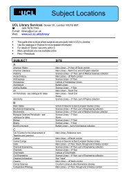
3/. The Survey Course - University College London
3/. The Survey Course - University College London
3/. The Survey Course - University College London

You also want an ePaper? Increase the reach of your titles
YUMPU automatically turns print PDFs into web optimized ePapers that Google loves.
precipitation the long dry valleys carry water southwards into the Lavant. <strong>The</strong> scarp<br />
ridge represents the watershed in this area; drainage from here is to the north into the<br />
catchment of the River Rother. Springs rise from the base of the Chalk, such as<br />
Coster’s Brook at Cocking and those to the east around Sutton and West Burton, at<br />
the eastern end of the Singleton Anticline (Fig. 4). Further springs emerge on the<br />
Gault Formation and form the SE-NE trending shallow valleys that are cut into the<br />
Folkestone and Sandgate Formations. <strong>The</strong> monuments are located on a ridge of high<br />
ground: Heyshott Down, between Manor Farm Down to the west and Graffham Down<br />
to the east. <strong>The</strong>y sit in a slight col between two high points at 233m OD; the ground<br />
immediately in the vicinity of the barrows rises from c. 225m at the westernmost<br />
barrow to c. 230m OD at the easternmost. <strong>The</strong> ground the barrows occupy is the<br />
highest section on the ridge between the Cocking Gap and the River Arun, the only<br />
higher ground is the hill at Crown Tegleaze, set back from the ridge above<br />
Upwaltham, which can be clearly seen in Figure 6.<br />
Fig. 8. Aerial photograph showing the site, the white track is the South Downs way.<br />
12