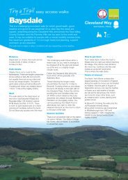
Clapham MTB Route - National Trails
Clapham MTB Route - National Trails
Clapham MTB Route - National Trails

Create successful ePaper yourself
Turn your PDF publications into a flip-book with our unique Google optimized e-Paper software.
'Off Road' Technical Difficulty<br />
Easy: Generally a hard smoothish surface<br />
Moderate: A more uneven surface<br />
Technical: Rough, uneven going. Difficult!<br />
Generalisations only. Allowance for weather also required.<br />
'Off Road' Path Type<br />
Bridleways (a black edging to a technical grade)<br />
Byways & other 'Off Roads' (no edgeing)<br />
Bridleways are for cyclists, walkers and horseriders and are generally<br />
well signposted. In particular the Pennine Bridleway is often<br />
signposted PBW. Mountain bikers must give way to people on foot<br />
or horseback.<br />
Uphill Indicator<br />
Shown along the marked route. It’s subjective but at least an<br />
indication of what is in store!<br />
Points Uphill<br />
Gradients / Heights<br />
310<br />
A65 from Kirkby Lonsdale<br />
& M6 Jct 36<br />
Also from A687 Lancaster<br />
& M6 Jct 34<br />
A65<br />
CLAPHAM<br />
B6480<br />
<strong>Clapham</strong> Station<br />
Along the <strong>Route</strong> General<br />
1 Leg Warmer 2 Pulse Racer 3 Lungbuster<br />
275<br />
Spot heights (metres) marked along the route<br />
Contours (25 metre intervals)<br />
Surface Descriptions<br />
As annotated on the map - generalisations only. Allowance for<br />
weather also required.<br />
'Off Road' Downhills<br />
Note : Long arrow in downhill direction<br />
This route guide includes subjective elements such as gradings,<br />
and generalisations such as surface descriptions (both these may<br />
change over time & will be affected by the weather). Maps and<br />
routes are for guidance only. It is up to you the cyclist to judge<br />
your own cycling competence, be aware of the conditions on the<br />
ground and be in control of your bicycle at all times. Whilst every<br />
effort has been made to ensure all the information presented is<br />
accurate we can not guarantee it is error free. In no event will any<br />
party involved in the making of this route guide be liable for any<br />
special, direct, indirect or consequential damages out of the use<br />
or inability to use the route guide.<br />
© Crown copyright. All rights reserved Natural<br />
England 100046223 2008<br />
This map has been designed and produced by Active<br />
Maps Ltd and includes original survey ©Active Maps Ltd<br />
For other mountain bike maps produced by Active Maps<br />
please visit www.bikemaps.co.uk/peak_district.htm<br />
O 1 mile<br />
O 1 km<br />
l l l ll l l l l l l l l l l<br />
300<br />
250<br />
A65<br />
200<br />
B6480<br />
Rocky<br />
loose stones<br />
280<br />
Stone<br />
Pillar<br />
Long 380<br />
Uneven plus<br />
Drop Off Scar<br />
Cairn<br />
Bear right<br />
1<br />
Grass<br />
3<br />
390<br />
320<br />
350 Watch the drop off<br />
at the bottom Bear right 3<br />
Rattle & Roll!<br />
Stones & Grit<br />
325<br />
300<br />
275<br />
250<br />
225<br />
AUSTWICK<br />
290<br />
250<br />
150<br />
150<br />
390<br />
1<br />
380<br />
Stone Pillar Grass<br />
385<br />
1<br />
300<br />
Grass<br />
Farm<br />
Tunnels:<br />
Advice to<br />
Dismount<br />
Cobbles,<br />
stones &<br />
rocks 205<br />
2<br />
Steep & tricky<br />
around the bend !<br />
Church<br />
A<br />
Store<br />
155<br />
Caution!<br />
3 225 235<br />
Gritty<br />
PBW<br />
Grass on<br />
hard base<br />
Taster<br />
B<br />
Caution! 200 PBW<br />
New Inn<br />
11<br />
LONG LANE<br />
P START A<br />
Crummack Dale Dabs<br />
Thwaite<br />
Scars<br />
THWAITE LANE<br />
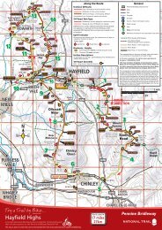
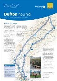
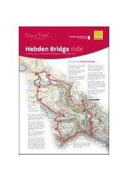
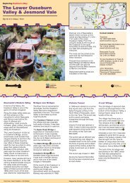
A circular Mountain Bike <strong>Route</strong> from <strong>Clapham</strong> that includes<br />
sections on the Pennine Bridleway <strong>National</strong> Trail.<br />
This map is part of a series that can be downloaded free from www.nationaltrail.co.uk/penninebridleway<br />
PBW<br />
P<br />
i<br />
5<br />
A<br />
'Off Road' not along the main route<br />
Minor Road 2: often single track<br />
Minor Road 1<br />
Main Road: ‘A’ and ‘B’ Roads<br />
The representation on this map of roads, tracks and<br />
paths is no evidence of the existence of a right of way.<br />
ROUTE<br />
DIRECTION<br />
Pennine Bridleway <strong>National</strong> Trail<br />
Gate<br />
Wall<br />
Footpath<br />
Car park<br />
Tourist / Visitor Information Centre<br />
Public House, Bar<br />
Cafe<br />
Miles from the Start<br />
Reference markers for<br />
text description (see over)<br />
1<br />
PBW<br />
G<br />
ROUTE<br />
DIRECTION<br />
10<br />
Take it easy Cattle<br />
3's are coming up!<br />
2 Grid<br />
Solid Base<br />
Track<br />
Norber<br />
Gamecock<br />
7<br />
Store<br />
ROUTE LENGTH<br />
12 miles<br />
20 km<br />
Ingleborough<br />
<strong>National</strong><br />
Nature Reserve<br />
Crummack<br />
Dale<br />
WALL<br />
E<br />
WALL<br />
Playing<br />
Fields<br />
9<br />
WOOD LA<br />
PBW<br />
WALL<br />
8<br />
Stone<br />
Building<br />
PBW<br />
3<br />
1<br />
225<br />
200<br />
155<br />
1<br />
170<br />
Thieves<br />
Moss<br />
A65<br />
Gritty<br />
Stone Building<br />
225<br />
Spin fast 2<br />
& you're soon up<br />
175<br />
200<br />
320<br />
WHARFE<br />
Gritty Singletrack<br />
1<br />
Sulber<br />
Stone<br />
Building<br />
225<br />
1<br />
SELSIDE<br />
2<br />
Borrins<br />
Grass<br />
(Limestone<br />
Pavement)<br />
Wood<br />
House<br />
WALL<br />
Moughton Scars<br />
2<br />
PBW<br />
F<br />
PBW<br />
ROUTE<br />
DIRECTION<br />
300<br />
350<br />
Slightly Rocky<br />
Singletrack<br />
Gritty Singletrack<br />
200<br />
South<br />
House<br />
Farm<br />
Studrigg<br />
Scar<br />
PBW<br />
6<br />
Wharfe<br />
Wood<br />
Gritty<br />
Concrete<br />
Prominent sign for<br />
South House<br />
2 Farm Barn<br />
290<br />
Beacon<br />
Grassy<br />
Light<br />
Grey<br />
Scars White House<br />
190<br />
Sign for Private<br />
Road, Footpath<br />
& Bridleway<br />
Stone<br />
Building<br />
270<br />
210<br />
B6479<br />
205<br />
300<br />
250<br />
235<br />
HORTON-IN-<br />
RIBBLESDALE<br />
1<br />
2<br />
Stone<br />
Barn<br />
Horton-in-Ribblesdale<br />
Station<br />
Lower Bark House<br />
High Bark<br />
House<br />
2<br />
4<br />
PBW<br />
N<br />
W E<br />
S<br />
C<br />
D<br />
Cattle<br />
Grid<br />
Broken Tarmac<br />
A65 from Skipton<br />
& from the A682<br />
Note: The distance<br />
along here is not shown<br />
to scale and is about<br />
1.7 miles (2.7km).<br />
350<br />
FEIZOR<br />
PBW<br />
Sharp left here<br />
(through the<br />
buildings)<br />
5<br />
Pennine Bridleway
METRES<br />
400<br />
300<br />
A varied mountain bike route that starts on tracks from <strong>Clapham</strong>, to Austwick, Feizor and Wharfe then takes you out<br />
into the open country of limestone scars and pavements with views of Ingleborough and Pen-y-ghent forming a wonderful<br />
backdrop. There are a few technical sections but for the most part the surfaces will not be too demanding on your<br />
mountain biking skills. Most of the climbing comes between 4 and 8 miles (Feizor to Crummack Dale); so there is a<br />
nice warm up section (not counting the short climb out of the <strong>Clapham</strong> Tunnels!) and a long generally downhill finish.<br />
For an option of starting at Horton-in-Ribblesdale & adding 6 miles to the distance see the train information below.<br />
A<br />
B<br />
C<br />
D<br />
Crummack Dale Dabs<br />
Mountain Bike <strong>Route</strong><br />
<strong>Route</strong> length: 12 miles / 20km. Rough Time 2 1 /2 to 5 hours.<br />
START<br />
<strong>Clapham</strong>. Car park just up the road from the New Inn.<br />
You are on the Pennine Bridleway <strong>National</strong> Trail<br />
in sections A, B, C, F & G.<br />
The points below are referenced on the map<br />
Exit <strong>Clapham</strong> Car Park and TR.<br />
TR immediately before church onto track & follow it round to the left<br />
(signed Austwick), through tunnels & up to top of steep climb. At track<br />
junction continue straight on & follow along then down to road junction<br />
(caution).<br />
Continue straight across onto track. Follow to road & TR.<br />
TL onto bridleway just after the 30mph sign. Proceed to & cross river.<br />
Follow to track junction and TL (do not take the grassy bridleway off<br />
to the left immediately before the junction).<br />
Follow straight on as it narrows to singletrack. Cross river then quickly<br />
BL at track fork by stone barn. Stay on this path to reach road at Feizor.<br />
TL onto road & climb through Feizor. Continue straight through a gate<br />
across the road & climb narrow lane. This soon turns to a track. Climb<br />
to gate across track then descend. BR at bend before first farm & onto<br />
second farm.<br />
Follow the track as it bends sharp left to go through the farm buildings<br />
and then descends to a road junction.<br />
TL onto road. Pass driveway for the 'White House'. Descend to a bend<br />
& TR onto track (signed 'Private Road, Public Footpath & Bridleway').<br />
Follow round left bend by 'Grey Scars' cottage then BR at track split.<br />
Pass 'Beacon Light' cottage, then BR at next two track junctions.<br />
The path now leaves Wharfe & starts a narrow climb. Keep on the main<br />
path & pass an isolated stone building on your left. Keep heading<br />
straight on, cross river and onto a main track junction.<br />
Abbreviations: TR-Turn Right, TL-Turn Left, BR-Bear Right, BL-Bear Left.<br />
<strong>Route</strong> Profile<br />
200<br />
B C<br />
A<br />
Feizor<br />
210m<br />
<strong>Clapham</strong> Austwick<br />
100 155m<br />
150m<br />
E<br />
F<br />
G<br />
TR & climb. When track bears right (private drive), go<br />
straight ahead on grassy bridleway & through gate. Keep<br />
wall on your right & about 100 metres before next gate<br />
TL & head up steep grassy path. The path is indistinct in<br />
this section (a good landmark is the wall on your right<br />
which you should keep roughly 100 metres from). Head<br />
straight up ignoring path splits to the left. The path then<br />
bears round to the right and gradient eases. The path<br />
splits again, keep straight on & follow to main path<br />
junction by a small stone pillar.<br />
For good views of the limestone pavement (geology<br />
feature) on your right continue straight on to the next<br />
gate (just after the gate the high wall on your right<br />
finishes).<br />
Now do an about turn and return along the path back<br />
to the stone pillar. BR at path split. Keep on this main<br />
path to arrive at another stone pillar. Keep straight on<br />
heading for a cairn on a small hummock.<br />
Pass near the cairn (which is a little way to your right) &<br />
now descend. At path junction BL & quickly arrive at<br />
gate. Straight through & down to next gate.<br />
Through this onto stony track descent. Follow for about<br />
1.5 miles to track junction & TR. Descend down & through<br />
tunnels (caution: dark and beware of other users). TL<br />
onto road & back to car park.<br />
Travelling to the Area by Train<br />
<strong>Clapham</strong> Station is one mile from the route and is suited for those travelling from Leeds or Morecombe. If travelling from<br />
Carlisle the route is accessible from Horton-in-Ribblesdale Station. If you use this station then be prepared to do an extra 6<br />
miles making the ride 18 miles/29km. The extra mileage might suit some and if travelling from Leeds it is also possible to catch<br />
a direct train to Horton-in-Ribbledsale. See directions below & the map for picking up and following the route.<br />
<strong>Clapham</strong> Station<br />
A possible Saturday Itinerary*<br />
From Leeds: Dep 10.19 • Arr <strong>Clapham</strong> 11.31<br />
Dep <strong>Clapham</strong> 17.14 • Arr Leeds 18.39<br />
From Morecombe: Depart 10.41 • Arrive <strong>Clapham</strong> 11.36<br />
Dep <strong>Clapham</strong> 17.58 • Arr Morecombe 18.59<br />
Horton-in-Ribblesdale Station<br />
A possible Saturday Itinerary*<br />
270m<br />
From Carlise: Dep 07.52 • Arr Horton-in-Ribblesdale 9.21<br />
Dep Horton-in-Ribblesdale 15.53 • Arrive Carlise 17.28<br />
From Leeds: Dep 08.49 • Arr Horton-in-Ribblesdale 09.58<br />
Dep Horton-in-Ribblesdale 15.56 • Arrive Leeds 17.07<br />
D E<br />
Wharfe<br />
190m<br />
F<br />
Moughton<br />
Scar<br />
380m<br />
To pick up the route from <strong>Clapham</strong> Station<br />
Out of the station exit and continue straight across (letter box on<br />
your left) and then quickly left at give way.<br />
Continue for about one mile to junction with main road.<br />
Straight across into <strong>Clapham</strong>. At T-junction TR, over bridge (New<br />
Inn facing you) then immediate left.<br />
Continue up to the church then as from point A above.<br />
To pick up the route from Horton-in-Ribblesdale Station<br />
Out of the station exit and TL onto the B4679. After about 1.5 miles<br />
pass a stone barn on the left. Take the next left, signs for a bridleway<br />
and also South House Farm Barn.<br />
At track split BR. Climb to next split and BL onto smaller track. Through<br />
gate and BL to next gate. Follow straight through. At path split head<br />
straight up and follow to gate. Straight through and onto next gate.<br />
You are now at point F .<br />
Follow the main directions above but continue straight on to the stone<br />
pillar and not an about turn!<br />
*please note this is for guidance only. Time taken on route will vary with individuals & train times may change. Please check with <strong>National</strong> Rail Enquiries for<br />
full service details (Tel: 08457 48 49 50 or www.nationalrail.co.uk). There is space for two bikes on the train & more at the conductor's discretion, on a first<br />
come first served basis (no booking required).<br />
Refreshments<br />
<strong>Clapham</strong> is a popular base for<br />
exploring the Dales and has a<br />
good selection of places to<br />
recharge after the ride or to<br />
top up before you start. There<br />
are a couple of cafes, the New<br />
Inn pub, a bar as well as a<br />
village store.<br />
At Austwick there is the Game<br />
Cock Inn and a store, & at<br />
Feizor a cafe.<br />
If arriving by train at Hortonin-Ribblesdale<br />
(see train info<br />
at bottom) there are a couple<br />
of pubs cafes and a store.<br />
Start of<br />
Long Lane<br />
G 320m<br />
1<br />
©Active Maps Ltd<br />
2 3 4 5 MILES 6 7 8<br />
9 10<br />
11<br />
12<br />
Long<br />
Scar<br />
390m<br />
<strong>Clapham</strong><br />
155m