Survey / Mapping CaTaLOgue - Topcon Europe Positioning
Survey / Mapping CaTaLOgue - Topcon Europe Positioning
Survey / Mapping CaTaLOgue - Topcon Europe Positioning

You also want an ePaper? Increase the reach of your titles
YUMPU automatically turns print PDFs into web optimized ePapers that Google loves.
<strong>Survey</strong> / <strong>Mapping</strong> <strong>CaTaLOgue</strong>
always innovative<br />
<strong>Topcon</strong> is the worldwide leading developer and manu-<br />
facturer of precision positioning equipment and offers a<br />
wide selection of innovative <strong>Survey</strong>ing, Engineering, GNSS<br />
systems, Laser, Machine Control solutions, Mobile <strong>Mapping</strong><br />
and GIS products.<br />
At <strong>Topcon</strong> we know your geo-business world is getting increasingly<br />
competitive. Therefore it is vital to constantly investigate<br />
and utilise each and every competitive advantage<br />
index Of COnTenS<br />
Page 2 Introduction<br />
Page 3 <strong>Topcon</strong> Technologies<br />
Page 4 - 5 The world of precision – <strong>Topcon</strong> solutions<br />
Page 6 MS AX – Measuring Stations<br />
Page 7 IS-3 – Imaging Station<br />
Page 8 PS – Robotic Total Stations<br />
Page 9 OS – Windows CE Total Station<br />
Page 9 ES – Reflectorless Total Stations<br />
Page 10 MAGNET Enterprise / MAGNET Office Topo<br />
Page 11 MAGNET Field / MAGNET Office Tools<br />
Page 12 DL-500 Series – Electronic digital level<br />
Page 13 HiPer II – Dual Frequency GNSS Receiver<br />
Page 14 GR-5 – Advanced GNSS Receiver<br />
Page 15 HiPer SR – Dual Frequency GNSS Receiver<br />
available with your positioning solutions to stay at the top of<br />
your profession. We pride ourselves in continually developing<br />
innovative and potentially world leading technologies.<br />
Utilising unique technologies, our products provide the best<br />
solutions to simplify and improve your everyday tasks.<br />
<strong>Topcon</strong>’s innovations help you increase your productivity,<br />
satisfy challenging demands of your clients and assist you<br />
to enter new markets.<br />
Page 16 Tesla RTK – GNSS Controller<br />
Page 16 Tesla – Field Controller<br />
Page 17 GRS-1 – Dual Frequency GNSS Controller<br />
Page 18 NET-G3A – GNSS CORS Receiver<br />
Page 18 GB-5 – GNSS Receiver<br />
Page 19 TopNET+ Correction Software<br />
Page 19 TopNETlive Service<br />
Page 20 FC-250 / FC-2600 – Rugged Field Controllers<br />
Page 21 FC-236 / FC-25A – Rugged Field Controllers<br />
Page 22 IP-S2 HD Compact+ / IP-S2 HD – Mobile <strong>Mapping</strong><br />
Page 23 GLS-1500 Laser Scanner / IS-3 Imaging Station<br />
Page 24 ImageMaster / ScanMaster Office Software<br />
Page 25 <strong>Topcon</strong> TotalCare / Technical Services<br />
Page 26 - 27 Product Application Matrix<br />
introduction<br />
At <strong>Topcon</strong> we understand that the choices available for<br />
positioning tools can sometimes seem a little bewildering;<br />
because of this, we have compiled this catalogue in order to<br />
assist you to make the right decisions as to what you need<br />
to for your specific projects.<br />
TOpCOn<br />
2
Technologies<br />
Overview <strong>Topcon</strong> Technologies used in diverse fields of application<br />
TSshield – offers cloud-based support to maximise your<br />
total station investment. Receive updated information when<br />
firmware is not up to date or view device information via<br />
a dedicated web portal. If ever lost or stolen, you can track<br />
its location and send a code that locks the instrument until<br />
it is recovered.<br />
Matrix detection – Available on our range of high precision<br />
MS AX sensors, this technology automatically locates<br />
any prisms within a specified area, totally eliminating<br />
the need for manual guidance even with close-up prisms<br />
adjacent to each other!<br />
Capture reality – With our imaging heritage, it’s no sur-<br />
prise to find imaging technology in many of our high end<br />
sensors. These allow users to not only measure, but to<br />
Capture Reality; using the IS-3, GLS-1500, IP-S2 mobile<br />
mapping and even from high resolution imagery from DSLR<br />
cameras.<br />
3<br />
LongLink – is our license-free long-range communcations<br />
technology for both GNSS and optical sensors.<br />
LongLink enhances workflows in many ways; data collectors<br />
can work where needed... at the remote position with both<br />
robotic and conventional total station. Or control multiple<br />
rovers from a single base using LongLink.<br />
Long range – The IS-3 Imaging Station features our incredible<br />
reflectorless technology which enables measurements<br />
of up to 2,000 m with pinpoint accuracy. Imagine being able<br />
to set up and carry out survey measurements from inaccessible<br />
locations or scan quarry faces from great distances.<br />
universal Tracking – <strong>Topcon</strong>’s G3 GNSS receivers feature<br />
our Universal Tracking technology, which allows for recep-<br />
tion of all currently available and future planned GNSS<br />
signals. It allows the future proofing of <strong>Topcon</strong>’s receivers by<br />
not restricting channel selection at the time of manufacture.<br />
vanguard – Our VanGuard chipset is the most advanced<br />
GNSS solution available. With 226 Universal Tracking channels<br />
offering L1 / L2 / L5 triple-frequency support for modernised<br />
multi-constellation GNSS systems, VanGuard has<br />
a compact ‘system-on-chip’ multi-core design and offers<br />
a comprehensive peripheral and networking interface.<br />
TeChnOLOgieS<br />
powerTrac – The revolutionary PowerTrac engine<br />
dramatically increases power for prism tracking. Employing<br />
entirely new optics, laser system, and further advanced<br />
algorithms, PowerTrac allows the PS Series to keep tracking<br />
a moving prism even under the toughest environmental<br />
conditions.<br />
fence antenna – Offering enhanced sensitivity not<br />
available with other RTK system, Fence Antenna is a revo-<br />
lutionary new antenna design. High performance low eleva-<br />
tion satellite tracking and advanced multipath suppression<br />
are just two of the significant features available on Fence<br />
Antenna systems such as GR-5, HiPer SR & PG-S1.
The world of precision – <strong>Topcon</strong> solutions<br />
<strong>Topcon</strong> offers – The most complete range of Total Stations<br />
on the Market today. With an ongoing commitment to only<br />
the best quality materials and ergonomic design characteristics,<br />
every instrument in the range is manufactured to exacting<br />
standards. This results in Total Stations that have a build<br />
quality that is second to none, high accuracy that will give<br />
years of reliable operation.<br />
TOpCOn SOLuTiOnS<br />
efficient and easy – Being able to offer easy to use<br />
software that integrates geographically related workflows<br />
in combination with our outstanding hardware is one of<br />
<strong>Topcon</strong>’s highest priorities. It doesn’t matter what industry<br />
you are from; Government, Utility and Infrastructure, Environment<br />
or Public Safety; with <strong>Topcon</strong>’s GIS and <strong>Mapping</strong><br />
solutions for handheld and Mobile <strong>Mapping</strong> systems you<br />
are able to fulfill all of your tasks in the most efficient and<br />
time-saving manner.<br />
Our comprehensive software solutions, which you are able<br />
to customise to your method of working, ensures that nonsurveyors<br />
are also able to carry out your required tasks and<br />
offers huge benefits to your organisation.<br />
Whether you are looking for a Total Station for a small<br />
construction project, a Robotic solution for <strong>Survey</strong>ing or<br />
a Monitoring Sensor, <strong>Topcon</strong> have the instrument to suit<br />
your needs. <strong>Topcon</strong>’s ethos of providing the best quality<br />
and attention to detail is evident throughout the range. The<br />
ease of use and dependability saves you time and money,<br />
no matter what your project.<br />
<strong>Survey</strong><br />
Precision Measurement<br />
GIS / <strong>Mapping</strong><br />
Mobile Data Gathering<br />
The world of precision<br />
l Engineering<br />
l Monitoring<br />
l Cadastral<br />
l Topographic<br />
l <strong>Survey</strong><br />
l Construction<br />
l Utilities<br />
l Governmental<br />
l Environment<br />
l Agriculture<br />
l Forestry<br />
l Asset Management<br />
4
<strong>Topcon</strong> solutions<br />
5<br />
l Engineering<br />
l <strong>Survey</strong><br />
l Construction<br />
l Photogrammetry<br />
l Forensics<br />
l 3D Visualisation<br />
l Engineering<br />
l Geomatics<br />
l Marine<br />
l Cadastral<br />
l <strong>Survey</strong><br />
l Networks<br />
Imaging<br />
Capture Reality<br />
GNSS<br />
Satellite <strong>Positioning</strong><br />
<strong>Topcon</strong> imaging products – enable you to Capture Reality<br />
and record all the detail on your project. What you see is<br />
what you get; the products focus on this unique functionality<br />
and combine the strengths of clear visual and accurate<br />
geometric information to allow you to communicate all<br />
job information and structure to your client. The Imaging<br />
product range ensures that you will always head back to the<br />
office with everything you need to deliver the end result,<br />
saving you time and money in the process.<br />
From discrete point measurement to complete full colour<br />
pointclouds the Imaging portfolio provides the right tool for<br />
every situation and scale of work. No job is too big or too<br />
small, <strong>Topcon</strong> have the solution you need to realise your<br />
vision.<br />
TOpCOn SOLuTiOnS<br />
intelligent gnSS workflow – By working with <strong>Topcon</strong>’s<br />
GNSS solutions, you are automatically adding intelligence<br />
into your workflows and job practices. Our extensive GNSS<br />
product range ensures that you can pick the right solution<br />
that fits your work tasks and needs.<br />
GNSS technology not only is used for identifying simple<br />
positioning tasks, it is becoming a baseline technology<br />
that couples coordinated positions with advanced toolsets<br />
to provide further value added information to more fully<br />
analyse operations and maintenance phases. Make use of<br />
it with our patented GNSS solution technology. With a comprehensive<br />
range of networks, recievers and antennas, we<br />
can supply your exact requirements.
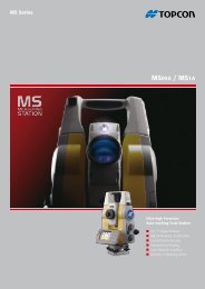
MS ax – Measuring Stations<br />
<strong>Topcon</strong>'s MS AX range of robotic total<br />
stations are the highest precision sensors<br />
available. Whether your measurement<br />
task involves monitoring prisms on a dam wall,<br />
alignment observations through a tunnel or high accuracy<br />
infrastructure layout, the MS AX is the perfect tool for the job.<br />
Designed specifically for projects where accuracy can not<br />
be compromised, the MS AX is available with either a 1" or<br />
<strong>Survey</strong><br />
Monitoring Solutions – In addition to supplying you with<br />
the most accurate and durable Monitoring Sensor on the<br />
market – the <strong>Topcon</strong> MS Series, <strong>Topcon</strong> offer all the additional<br />
hardware and software required for any monitoring<br />
project. With off the shelf solutions to control and power<br />
one instrument. For multiple instrument networked solutions,<br />
we have a package which is suitable for you.<br />
Automatic and comprehensive reporting of displacement is<br />
available throughout the range, with SMS and mail notification<br />
when tolerances are exceeded.<br />
super precision 0.5" angular measurements and 0.5 mm<br />
distance measurement.<br />
Featuring the revolutionary Matrix Detection Monitoring<br />
technology, the MS AX can make the estabishment of large<br />
number targets on a monitoring or tunnelling project a rapid<br />
and simple task, completely eliminating user errors.<br />
MS AX Package<br />
key feaTureS - MS AX<br />
l 0.5” / 1” Angular Accuracy (MS05AX / MS1AX)<br />
l Distance Accuracy of 0.5 mm<br />
l 1" / 1 mm over 100 m Auto-Collimation Accuracy<br />
l Matrix Detection for auto-target detection<br />
l Pinpoint 400 m Reflectorless Range (MS1AX)<br />
l Complete System<br />
— MS AX 0.5" or 1" Instrument<br />
— Dual Charging Cradle<br />
Total Stations – MS05ax / MS1ax<br />
— Choice of optional field controllers<br />
— Li-Ion Batteries<br />
— Compact Carry Case<br />
— Onboard Software<br />
— Compatible with third party<br />
monitoring solutions<br />
MSP Software<br />
— Manuals & Utility software<br />
6
Total Stations – iS-301 / iS-303 / iS-305<br />
iS-3 – imaging Stations<br />
Take the power, accuracy and speed of the<br />
innovative <strong>Topcon</strong> robotic instruments,<br />
add our legendary imaging capabilities and<br />
faster scanning speeds... and you have the IS-3.<br />
With dual wide angle and coaxial imaging sensors, superior<br />
tracking technology, up to 2 km reflectorless range, integrated<br />
WiFi and interference free 2.4 GHz Spread Spectrum<br />
WT-100 – Using the new WT-100 wireless data link device,<br />
users can dramtically extend their wireless working range...<br />
now up to 300 m!<br />
This means that users are able to increase the range with<br />
which they can use the incredible 10 frames per second live<br />
video feed from the IS to lock on to the prism with pin point<br />
precision using iDRIVE.<br />
7<br />
data communications, the IS-3 is the most advanced and<br />
powerful imaging robotic station available. Incorparating<br />
our fast iSCAN measurement routine to enable thorough<br />
automated data collection defining your subject using<br />
real-time image capture: options include Feature Detection<br />
or Grid Scan to automatically measure significant points or<br />
a 'regular' grid.<br />
WT-100<br />
IS Package<br />
key feaTureS - IS-3<br />
l Twin Cameras – wide angle and coaxial for true through the lens view<br />
l iSCAN intelligent feature scanning<br />
l 20 points per second scan rate, with 2000 m range<br />
l iDRIVE lets you visually operate from the controller and easily switch<br />
from imaging to prism tracking<br />
l Photo Fieldbook – creates a 360° panorama in seconds<br />
l Long range wireless with up to 10 fps<br />
l Complete imaging robotic System<br />
— IS-3 1”, 3” or 5” Instrument<br />
— Charging Cradles<br />
— Choice of field controllers<br />
— WT-100 WiFi device<br />
— Lightweight 360° prism<br />
— Onboard Software<br />
— ImageMaster (Remote Control<br />
and Office Processing software)<br />
— Manuals & Utility software<br />
<strong>Survey</strong>
pS – robotic Total Stations<br />
This new advanced solution features an<br />
incredible array of new and existing features,<br />
including TSshield for advanced<br />
security and maintenance, PowerTrac tracking technology,<br />
IP65 environment rating and our exclusive LongLink –<br />
offering up to 600 m wireless communication.<br />
<strong>Survey</strong><br />
inTegraTed <strong>Survey</strong>ing<br />
By integrating GNSS RTN (Network RTK) and Robotic<br />
Total Station (RTS) technologies, your job site<br />
productivity can be increased dramatically.<br />
By using the PS robotic with our handheld GRS-1<br />
RTK controller & PG-S1 antenna and MAGNET Field,<br />
this method of working is easy!<br />
l Standard packages<br />
— PS Total Station<br />
— Battery and Charger<br />
— Lens Cap and Hood<br />
— Tool Kit<br />
— Quick Guide and Digital Manual<br />
— Carry Case and Carry Straps<br />
The new RC-5 quick-lock sub-system improves prism<br />
searching and finding capabilities, whilst the IACS advanced<br />
angular accuracy and powerful & accurate EDM make this<br />
the most advanced robotic total station available.<br />
You can work directly on the bright, colour touchscreen or<br />
with the alphanumeric keyboard, to achieve higher levels of<br />
production with MAGNET Field on-board software.<br />
PS Package<br />
key feaTureS - PS<br />
l PowerTrac prism tracking<br />
l LongLink Communications Technology<br />
l TSshield Security and Maintenance<br />
l IP65 dust and waterproof rating<br />
l IACS automatic angle measurement calibration<br />
l Large graphic and colour touchscreen<br />
PS RC-5<br />
MAGNET<br />
Total Stations – pS-101 / pS-103 / pS-105<br />
GRS-1<br />
Field Controllers<br />
FC-250<br />
FC-2600<br />
Tesla<br />
8
Total Stations – eS-102 / eS-103 / eS-105 / eS-107 · OS-101 / OS-102 / OS-105<br />
OS – Windows Ce Total Stations / eS – reflectorless Total Stations<br />
The OS Series – is an entirely new<br />
instrument based around a rugged<br />
and weather proof IP65 magnesiumalloy<br />
construction, featuring Windows Mobile and running<br />
MAGNET Field on board. Using our long range LongLink<br />
technology, job control is where it’s needed... at the detail<br />
pole, enhancing data collection and dramatically improving<br />
stakeout speed and accuracy.<br />
l Standard packages<br />
— OS Total Station<br />
— Battery and Charger<br />
— Lens Cap and Hood<br />
— Tool Kit<br />
— Digital Manual on USB<br />
— Quick Guide<br />
— Carry Case and Carry Straps<br />
9<br />
The eS Series – redefines construction grade total<br />
stations, introducing a number of new features, all combined<br />
in a small lightweight package. It has an extended<br />
reflectorless range of up to 500 m and can also measure to<br />
standard prisms at a range of 4,000 m. The ES also sees the<br />
introduction of our TSshield remote service and LongLink<br />
technology.<br />
MAGNET<br />
ES<br />
key feaTureS - OS<br />
l Advanced Security and Maintenance with New TSshield<br />
l MAGNET Field On-board<br />
l Exclusive LongLink Communications Functionality<br />
l Fast and Powerful EDM<br />
l Advanced Angle Accuracy<br />
key feaTureS - ES<br />
l Advanced Security & Maintenance with New TSshield<br />
l Exclusive LongLink Communications Functionality<br />
l Fast and Powerful EDM<br />
l Advanced Angle Accuracy<br />
l Super Long Battery Life – 36 Hours!<br />
l Rugged, Waterproof Design<br />
l Standard packages<br />
— ES Total Station<br />
— Battery and Charger<br />
— Lens Cap and Hood<br />
— Tool Kit<br />
— Digital Manual on USB<br />
— Quick Guide<br />
— Carry Case and Straps<br />
OS Package ES Package<br />
<strong>Survey</strong>
MagneT enterprise / MagneT Office Topo<br />
MagneT enterprise – The cloud-based environment that<br />
simplifies the maintenance and management of field and<br />
office data workflows. Track assets and communicate with<br />
everyone involved in a project. Login from any browser for<br />
data exchange, internet chat, and to observe field measurement<br />
plotting within Google Maps in real-time.<br />
SOfTWare<br />
MagneT Office Topo – provides you with the complete<br />
desktop survey solution. Whether it’s a simple boundary<br />
survey with a one page print out of the site or a complicated<br />
multi-surface construction jobsite with roads, utilities,<br />
machine control, and buildings, Office Topo gives you<br />
everything you need to complete a project.<br />
The heart of MAGNET Enterprise is a web browser environment<br />
that runs with Widgets that allow complete configuration<br />
of how you like to work, so that you have what you<br />
need, where and when you need it. All it takes is a web<br />
browser to communicate, collaborate, and exchange data.<br />
Chat<br />
Projects<br />
e-Message<br />
Map<br />
Mail<br />
Data Manager<br />
Software – MagneT enterprise / MagneT Office Topo<br />
key feaTureS - MAGNET Enterprise<br />
l Team-based collaboration<br />
l Secure Cloud Storage – 500 MB standard, add more as needed<br />
l Exchange data between field and office in real time<br />
l Live chat with multiple members<br />
l Automated e-mail alerts<br />
l View surveyed points and lines overlaid on the Google ® map<br />
key feaTureS - MAGNET Office<br />
From field-to finish, control the critical data flow from data<br />
collection, raw file analysis, engineering design, to final print<br />
copy or customer specified export format.<br />
Office Topo is also Enterprise-enabled, simply subscribe to<br />
MAGNET Enterprise and upload, download, communicate<br />
and gather data in ‘Real-Time’ from the field with just a<br />
touch of a button.<br />
l Enterprise cloud storage and data exchange<br />
l Standalone or add-on for AutoCAD<br />
l Full Processing and Adjustment<br />
l DTM creation, volume and section analysis<br />
l Multiple Graphical Data Views<br />
The solution features numerous COGO and survey specific<br />
routines, functions such as bearing / distance intersections,<br />
and calculation of point position from offset and distance<br />
data are available. <strong>Survey</strong> specific tools such as traverse<br />
editors, deed editors, legal description writer, point translations,<br />
and many more are at your fingertips.<br />
10
Software – MagneT field / MagneT Office Tools<br />
MagneT field / MagneT Office Tools<br />
MagneT field – Available to run on our range of field<br />
controllers as well as on board our OS reflectorless and PS<br />
robotic total stations, MAGNET Field takes care of all your<br />
field operations from data transfer and management, control<br />
establishment, topographic survey, volume calculations<br />
stakeout, scanning, COGO and much more besides.<br />
MagneT Tools – Available standalone or as an AutoCAD<br />
Civil 3D embedded interface, Office Tools is processing<br />
software for positioning applications. All versions have<br />
direct connections to MAGNET Enterprise cloud storage and<br />
internet chat.<br />
11<br />
Tools<br />
Working with MAGNET Enterprise, your data can be transferred<br />
from MAGNET Field in real time to your office operatives<br />
running MAGNET Office, who can then carry out<br />
required processing and then transfer the data back to the<br />
field to implement, for instance, last minute design changes<br />
to a construction site.<br />
MAGNET<br />
News<br />
Networks<br />
Asset Manager<br />
key feaTureS - MAGNET Field<br />
key feaTureS - MAGNET Tools<br />
Stay connected with the field by exchanging files or even<br />
watching field measurements appear on the Tools screen in<br />
real-time... imagine seeing live shots with coded line work<br />
appear on your screen.<br />
Office Tools allows you to collect, process and adjust all your<br />
site data directly from your <strong>Topcon</strong> devices or remotely via<br />
l Intuitive Graphical Interface<br />
l Real time data transfer through MAGNET Exchange<br />
l Runs on controllers and total stations<br />
l Full COGO functionality<br />
l On board volume calculations<br />
l MAGNET Field supported<br />
l Post Process: GPS, GLONASS, RINEX<br />
l Reports including graphic views and report templates<br />
l Including 2D, 3D, and Google ® Earth views<br />
l Broad import / export format flexibility<br />
SOfTWare<br />
an internet connection from your regional CORS network<br />
Post-process using Static, Kinematic, Stop and Go methods.<br />
Carry out full Least Squares adjustment and produce wide<br />
ranging reports which can be output to Word, Excel or<br />
HTML. Choose from a number of graphical map, time based<br />
or tabular representations of the data.
dL-500 Series – electronic digital level<br />
dL-501 – This digital level has been designed to achieve<br />
the highest level of precision and productivity in levelling<br />
and height measurement applications. Featuring a wireless<br />
operation, a number of innovative technologies are implemented<br />
for unmatched productivity while eliminating error<br />
factors during measurement. The DL-501 sets the ultimate<br />
benchmark in precision digital levels.<br />
<strong>Survey</strong><br />
dL-502 / 503 – These digital levels maximise work efficiency<br />
whilst at the same time minimise human errors, providing<br />
consistent measurement precision and speed regardless<br />
of the operator’s skill level.<br />
Incorporating cutting-edge Random-Bidirectional (RAB)<br />
coding technology, the DL-502 / 503 provides exceptional<br />
accuracy, stability and speed, under a variety of environmental<br />
conditions. Even when the staff surface is partially<br />
shaded, or in low lighting conditions the DL-502 / 503 instantly<br />
shows reliable results. Using the world’s first “Waveand-Read”<br />
technology, the DL-502 / 503 allows the rod person<br />
to wave the staff back and forth, instead of keeping the<br />
staff plumb, so identifying the true and correct staff reading.<br />
The DL-501 is capable of achieving an incredible 0.2 mm<br />
measurement precision when used with our original Super-<br />
Invar RAB-Code Staves. It also features onboard software<br />
which supports height difference measurement and data<br />
recording in the following procedures: BF, BFFB, BBFF, BFBF,<br />
aBF, aBFFB, aFBBF. Measurement tolerances can be set in<br />
each route for on-site accuracy checks.<br />
DL-502/503<br />
DL-502 Package<br />
key feaTureS - DL-501<br />
key feaTureS - DL-502 / 503<br />
digital Level – dL-501 / dL-502 / dL-503 Series<br />
l 0.2 mm precision (ISO17123-2)<br />
l Optional Remote Trigger for wireless operation<br />
l Dual-axis Tilt Sensor<br />
l SD Card for Data Storage<br />
l BIS20A / 30A staff with ±0.1 ppm / ºC linear expansion coefficient<br />
l Weight (including battery) 3.4 kg<br />
l Fast 1.5 second measuring time<br />
l Auto-detection of staff attitude<br />
l Ability to measure lowest height on rocking staff<br />
l Sub-millimetre mesaurement accuracy<br />
l Extended 16 hours battery life<br />
l Standard configuration<br />
– DL-502 / 503 Digital Level unit<br />
– BDC46B Li-ion battery<br />
– CDC68 charger<br />
– EDC113 AC power cable<br />
– Hex wrench<br />
– Vinyl cover<br />
– User manual<br />
– Carrying case<br />
12
gnSS receiver – hiper ll Series<br />
hiper ii – dual frequency gnSS receiver<br />
The hiper ii – receiver is designed on<br />
these clearcut concepts. This state-ofthe-art<br />
receiver not only offers further<br />
enhanced ability, but also increases receiver performance<br />
and user-friendliness. The fully customisable structure provides<br />
maximum flexibility to choose your required options.<br />
l dual receiver package<br />
— Two HiPer II Receivers<br />
— Charging Cradles<br />
— PC Data Cables<br />
— Hard Carry Case<br />
— Radio Antennas<br />
— Manuals & Utility software<br />
— Fixed Height Tripod<br />
13<br />
HiPer II Package<br />
Our GPS+GLONASS, dual-frequency signal tracking technology<br />
offers superior positioning capability over the GPS<br />
only receivers. It makes a real difference where sky visibility<br />
is limited such as in urban canyons or in woodlands, near tall<br />
fences or other blockages. With integrated UHF Radio and<br />
GSM Cellular Modems available it's simple to work in the<br />
environment of your choosing.<br />
key feaTureS - HiPer II<br />
l Dual frequency GPS & GLONASS<br />
l Magnesium-Alloy Construction<br />
l Bluetooth ® connectivity<br />
l Integrated UHF Radio & GSM Modems<br />
l SD / SDHC Memory Card Slot for flexible storage options<br />
MAGNET<br />
FC-236<br />
Field Controllers<br />
FC-250<br />
FC-2600<br />
Tesla<br />
gnSS
gr-5 – advanced gnSS receiver<br />
Offering advanced design features not<br />
found in other receivers, the GR-5’s<br />
modern design provides the flexibility<br />
and ease-of-use you demand.<br />
With a rugged magnesium I-beam construction for unbeat-<br />
able strength and durability, and incorporating our Fence<br />
Antenna technology for unparalleled tracking perfor-<br />
gnSS<br />
l dual receiver package<br />
— Two GR-5 Receivers<br />
— Charging Cradles<br />
— PC Data Cables<br />
— Hard Carry Case<br />
— Radio Antennas<br />
— Manuals & Utility software<br />
— Fixed Height Tripod<br />
mance, the GR-5 also boasts easily accessible SDHC card<br />
memory and dual hot-swappable batteries for unlimited<br />
continuous operation.<br />
As well as being totally committed to the GPS, GLONASS<br />
and GALILEO satellite systems, <strong>Topcon</strong> is also committed<br />
to the precision signals from the developing systems from<br />
China, Japan and India.<br />
GR-5 Package<br />
key feaTureS - GR-5<br />
l 216 Universal Tracking Channels<br />
l Multi-constellation (GPS, GLONASS, GALILEO)<br />
l FenceAntenna Technology<br />
l Multiple Radio and Cellular Modem combinations<br />
l SDHC data storage support<br />
GR-5<br />
FC-236<br />
gnSS receiver – gr-5 Series<br />
GR-5<br />
Field Controllers<br />
FC-250<br />
FC-2600<br />
Tesla<br />
14
gnSS receiver – hiper Sr Series<br />
hiper Sr – dual frequency gnSS receiver<br />
Cable-free and simple to operate, the<br />
HiPer SR is the most compact base and<br />
rover RTK system available.<br />
The field-rugged and fully-integrated design delivers a 300<br />
meter working radius through <strong>Topcon</strong>’s new LongLink<br />
technology. This innovative wireless data link was developed<br />
specifically for the HiPer SR, and provides reliable and<br />
universal Tracking - While other GNSS receiver designs<br />
must dedicate channels to a specific satellite system or<br />
signal – requiring more and more channels as additional<br />
GNSS signals become available – with Universal Tracking<br />
Channels, any channel can track any available signal.<br />
15<br />
interference-free RTK base-to-rover communications that<br />
don’t require an FCC license to operate.<br />
Our VanGuard GNSS chip is at the heart of the HiPer SR. In<br />
addition to precision measurement and advanced multipath<br />
rejection, the chip offers support for all modernised GNSS<br />
constellations and incorporates <strong>Topcon</strong>’s patented Universal<br />
Tracking Channel technology.<br />
MAGNET<br />
HiPer SR Package<br />
key feaTureS - HiPer SR<br />
l Vanguard GNSS Board Technology<br />
l Quartz Lock Loop technology<br />
l Simultaneous LongLink operation with multiple rovers;<br />
l Sealed battery pack for up to 15 hours operation;<br />
l Lightweight and shock-resistant magnesium alloy housing<br />
l Withstands a 2 meter pole drop onto concrete.<br />
HiPer SR FenceAntenna HiPer SR Powerunit<br />
l dual receiver package<br />
— Two HiPer SR units<br />
— Battery Charger<br />
— Tribrach with adapter<br />
— 10 cm pole adapter<br />
— Mini USB cable / Serial Cable<br />
— Carrying Case<br />
gnSS
Tesla rTk – gnSS Controller / Tesla – field Controller<br />
Tesla rTk – The <strong>Topcon</strong> Tesla RTK<br />
builds on its field controller sibling; with<br />
the integrated RTK level GNSS receivers,<br />
it is the largest screen, single-handed, handheld controller<br />
on the market that can also be utilised as a network RTK<br />
rover.<br />
gnSS<br />
Tesla<br />
Tesla – The Tesla’s most prominent feature is its screen…<br />
with a large 5.7” full colour VGA LCD display, and a full active<br />
viewing area, switching from landscape to portrait; you can<br />
use the device exactly how you need to, for all applications.<br />
Available in three different versions; with the top of the<br />
range featuring GPS and DGPS (WAAS) functionality, 3.2 MP<br />
Make full use of the MAGNET Field user experience; using<br />
touchscreen technology, the Tesla RTK features direct touch<br />
access to all graphic controls. MAGNET Field is optimised<br />
for the display, while the Windows ® Mobile 6.5.3 provides a<br />
modern interface and added expansion application options.<br />
The fast 806 MHz processor drives any <strong>Topcon</strong> field application<br />
software with ease.<br />
MAGNET<br />
gnSS Controller – Tesla rTk / field Controller – Tesla<br />
key feaTureS - Tesla RTK<br />
key feaTureS - Tesla<br />
digital camera and 3 G GSM cellular modem connectivity for<br />
full communication capabilities.<br />
Using the integrated WiFi, Bluetooth or RS232C Serial con-<br />
nection, the Tesla can be used as an advanced field com-<br />
puter our GNSS receiver range or total stations such as our<br />
IS-3 or PS.<br />
l Integrated RTK GNSS receiver<br />
l Large 5.7” VGA Color Touchscreen<br />
l Fast 806 MHz processor<br />
l IP67 Environment Rating<br />
l 3.2 MP Camera<br />
l 3.5 G Cellular module<br />
l 5.7” Full Colour Touch Screen<br />
l Environment Proofing to IP67<br />
l Bluetooth, WiFi 802.11b/g<br />
l Cell Modem, 3.2 MP Camera & GNSS options<br />
l Hot-swappable batteries<br />
l Windows Mobile 6.5.3<br />
PG-S1<br />
16
gnSS Controller – grS-1<br />
grS-1 – dual frequency gnSS Controller<br />
<strong>Topcon</strong>'s GRS-1 is the world's smallest<br />
and lightest handheld RTK controller / receiver.<br />
By integrating a dual frequency GPS /<br />
GLONASS receiver board and L1 capable antenna within<br />
the unit, the GRS-1 can be used as the perfect handheld<br />
mapping grade unit. With the addition of a G3-A1 surveygrade<br />
external antenna the unit can be easily and quickly<br />
converted into RTK level device.<br />
The GRS-1 has a number of options available to allow it to<br />
connect into different corrections services. The internal cell<br />
modem and RH-1 UHF radio pack can be use to achieve<br />
centimetric level RTN positioning. You can also use the<br />
cell modem for DGNSS correction services, or the BR-1<br />
Bluetooth ® connected Beacon receiver can be used to get<br />
high accuracy mapping grade positons free of charge.<br />
17<br />
BR-1<br />
The internal GSM cellular modem can be used to receive<br />
NTRIP based corrections from your local TopNET+ network<br />
correction service, or you can use the optional RH-1 radio<br />
pack to connect into a local UHF based system. With an<br />
internal digital camera, integrated compass and fast, the<br />
GRS-1 has everything you need to get the job done quickly<br />
and efficiently!<br />
GRS-1 Package<br />
key feaTureS - GRS-1<br />
l Small and lightweight design<br />
l Internal GSM Modem for easy network connectivity<br />
l Scalable and expandable system<br />
l Integrated digital compass<br />
l Handheld or on Pole - m to cm accuracy<br />
GRS-1<br />
MAGNET<br />
l Standard configuration<br />
– GRS-1<br />
– BT-66Q Li-ion battery<br />
– BC-30 charger<br />
– AC power cable<br />
– Vinyl cover<br />
– User manual<br />
– Carrying case<br />
gnSS
neT-g3a – gnSS COrS receiver / gB-5 – gnSS receiver<br />
The NET-G3A is the World’s First reference<br />
receiver to provide Universal Signal<br />
Tracking. Using a patented technology,<br />
the NET-G3A incorporates 144 Universal Tracking Channels,<br />
capable of tracking signals from all available systems (GPS,<br />
GLONASS, GALILEO) as well as all future planned satellite<br />
positioning constellations.<br />
gnSS<br />
GB-3<br />
NET-G3A<br />
The gB-3 – introduces our incredible G3 technology to us-<br />
ers who like to keep their options open when it comes to<br />
configurations. Featuring the latest 72 Universal Channel G3<br />
Technology capable of receiving signals from all present and<br />
future satellite constellations GPS, GLONASS and GALILEO.<br />
A stand alone receiver without internal antenna or modem,<br />
the GB-3 offers maximum flexibility for use as a reference<br />
stations, mobile base station for RTK, static or kinematic<br />
survey of RTK rover backpack solutions.<br />
The NET-G3A is intended for use as a highly sophisticated<br />
CORS (Continually Operating Reference Station), whether<br />
this is working alone as a standalone base station on a local<br />
worksite or as part of a regional or national network correction<br />
service. With an integrated web interface, the NET-G3A<br />
can be configured remotely via your standard web browser.<br />
GB-3 - Versatile G3 GNSS Receiver<br />
key feaTureS - NET-G3A<br />
l 144 Universal Channel Paradigm-G3 Chip<br />
l Multi-Constellation Technology<br />
l Low power consumption<br />
l Superior Signal tracking and Performance<br />
l Compatible with ALL signals for existing and planned<br />
satellite navigation systems<br />
key feaTureS - GB-3<br />
l Dual frequency receiver<br />
l Flexible system<br />
l Suitable for base station static or backpack solutions<br />
l 72 Universal Channel G3 Chip Technology<br />
l Selectable Port Configuration<br />
gnSS receivers – neT-g3a / gB-3<br />
G3-A1 – Geodetic Antenna<br />
18
Software and Solutions – TopneT+ / TopneTlive<br />
TopneT+ Correction Software / TopneTlive Service<br />
TopneT+ – Is <strong>Topcon</strong>'s dedicated GNSS network correc-<br />
tion software which is in use throughout <strong>Europe</strong> providing<br />
correction services for end users. Subscribers to such services<br />
can carry out their usual surveying activities without<br />
the need for a GNSS base station, as network corrections<br />
are supplied to the rover using a low cost GPRS connection,<br />
offering real time positioning in the coordinate system of<br />
TopneTlive – is our GNSS network, which brings together<br />
our strategy for global GNSS services. These offer subscription<br />
based, high quality real-time GNSS network RTK and<br />
DGNSS correction data for many applications including<br />
surveying, construction, GIS mapping and machine control.<br />
19<br />
TopNET+<br />
your choice. With a number of different accuracy levels<br />
available, TopNET+ subscription services can be used for<br />
mapping level activities such as local authoriuty asset management,<br />
precision agricultural tasks, up to the highest level<br />
of Network RTK suitable for most surveying, engineering<br />
and machine control projects.<br />
GPS GLONASS<br />
DGNSS<br />
Handheld<br />
Reference<br />
Station<br />
key feaTureS - TopNET+<br />
Eliminating the setup of base stations, network solutions<br />
offer many advantages to surveyors, construction site<br />
and machine operators requiring RTK correction data on<br />
demand. GNSS users working anywhere within the net-<br />
l Multi-constellation system<br />
l Fully scalable solution<br />
l Choice of communications type<br />
l Quality monitoring of satellite and site parameters<br />
l Automated email based warning system Station<br />
l Upgrade from CORS to VRS Network Correction service<br />
key feaTureS - TopNETlive<br />
l Immediate start of increased productivity<br />
l Minimises base station investment<br />
l Maximise the job focus<br />
l Leave base station security worries behind<br />
l Always work with a constant level of precision<br />
l Online user management tools<br />
gnSS<br />
work boundary, can connect to TopNET live services with<br />
a mobile internet connection, and receive fully modelled<br />
Network RTK corrections.
ugged field Controllers<br />
fC-250 – If you are looking for a compact controller that pro-<br />
vides incredible performance, look no further than <strong>Topcon</strong>’s<br />
FC-250. Incorporating Windows Mobile 6.5 operating system<br />
with a crisp, bright, colour touch screen display the FC-250<br />
really makes your field data come alive. With the dual removable<br />
media for data storage and transfer, the easy to access<br />
rechargeable battery and the compact handheld design,<br />
fieLd COnTrOLLerS<br />
The fC-2600 – ruggedised and waterproof full keyboard<br />
interface makes for a perfect controller. Large keys ensure<br />
correct data entry, even with gloved hands! Bluetooth ®<br />
connect to your robotic total station or GNSS receiver for<br />
wireless control. The LCD display is crisp and bright, even<br />
in direct sunlight.<br />
FC-250 is the perfect field controller for any job. The FC-250<br />
also provides a wide range of wireless technologies, coming<br />
as standard with Bluetooth and WiFi. It also has the options<br />
to use the Snap-In RS-1 Spread Spectrum Radio for use with<br />
our QS & IS ranges of robotic total stations.<br />
FC-250<br />
FC-2600<br />
key feaTureS - FC-250<br />
field Controllers – fC-250 / fC-2600<br />
l Rugged environmental protection to IP66<br />
l WiFi, Bluetooth and optional RS-1 Wireless functionality<br />
l Ultra-bright full-colour 3.8” VGA touch-screen display<br />
l Ultra-bright full-colour 3.8” VGA touch-screen display<br />
l Fast 806 MHz processor easily handles all processing needs<br />
l Multiple data transfer options, SD & CF Card and USB Sticks<br />
key feaTureS - FC-2600<br />
The FC-2600 has built-in WiFi communication that connects<br />
to the <strong>Topcon</strong> Imaging Station. The connection can be made<br />
directly to the IS, or to the extended range WT-100, for a productive<br />
Live Video display robotic system. With an incredible<br />
battery life of up to 42 hours, the FC-2500 also features<br />
dual hotswappable Li-Ion batteries.<br />
l High resolution 5 MP digital camera<br />
l IP67 and MIL-STD 810F Environmental Protection<br />
l 55 key alpha-numeric keyboard for ease of data entry<br />
l Hot-swappable Li-Ion batteries for infinite work-time<br />
l Comprehensive Wireless connectivity options<br />
l Windows CE 6.0 Operating System<br />
20
field Controllers – fC-236 / fC-25a<br />
rugged field Controllers<br />
Our fC-236 – packs a huge number of features into a<br />
compact and lightweight unit. With full numeric keypad,<br />
extended and intelligent battery life, integrated cellular modem,<br />
3 MP camera, internal L1 GPS receiver, compass and<br />
powerful Windows Mobile operating system, this controller<br />
has everything you could possibly need as a field computer<br />
system and more!<br />
fC-25a – Featuring an exceptionally rugged, pocket-sized<br />
and lightweight construction, the <strong>Topcon</strong> FC-25A is the<br />
controller designed to work in the most severe work site<br />
conditions.<br />
With environmental rating of IP65 and MIL-STD-810G, the<br />
FC-25A will work where ever you need it to work. It is also<br />
the smallest and lightest controller available. Weighing in at<br />
21<br />
Coming as standard with a 806 MHz processor, Windows<br />
Mobile, 4 GB of flash memory and 128 MB RAM, the integrated<br />
SDHC card slot allows for Secure Digital cards up to<br />
16 GB to be used for data storage and transport.<br />
FC-236<br />
FC-25A<br />
key feaTureS - FC-236<br />
key feaTureS - FC-25A<br />
only 320 gm and measuring only 144 mm tall by 83 mm<br />
wide, you'll forget you are carrying it! The embedded<br />
20 channel GPS chipset provides positional information by<br />
point positioning or by DGPS using SBAS corrections.<br />
The FC-25A also incorporates a 3 MP auto focus camera,<br />
electronic compass and an altimeter for GIS data collection<br />
applications.<br />
l Integrated SiRF Star III GPS receiver<br />
l WiFi, Bluetooth ® and Cell modem for wireless data exchange<br />
l Multiple connectivity options for data transfer<br />
l 3 Mega Pixel Auto-focus Camera<br />
l Industry leading IP67 & MIL-STD-810G Environmental Protection<br />
l Incredibly lightweight field controller (320 g)<br />
l Rugged design with IP65 Ingress Protection<br />
l WLAN / Bluetooth ® Wireless<br />
l Field-exchangeable Li-ion Battery<br />
l Integrated digital camera, compass and altimeter<br />
fieLd COnTrOLLerS
ip-S2 hd Compact+ / ip-S2 hd – Mobile <strong>Mapping</strong><br />
<strong>Topcon</strong>’s IP-S2 Mobile <strong>Mapping</strong> System<br />
overcomes the challenges of mapping 3D<br />
features at a high level of accuracy and<br />
speed. Accurate vehicle positions are obtained using three<br />
technologies:<br />
– dual frequency GNSS receiver<br />
– inertial Measurement Unit (IMU)<br />
– external wheel encoders<br />
giS / <strong>Mapping</strong><br />
HDL-64E<br />
VELODYNE LASER SCANNER HDL-64E<br />
scans both sides of features<br />
64<br />
LASERS<br />
26,8“<br />
120 m<br />
data post processing – Tracking both GPS and GLONASS<br />
signals, the inertial measurement unit (IMU) and wheel sen-<br />
sors allow to accurately determine the location of the scan<br />
data and images collected... even if the data was collected<br />
while driving near obstructions or through tunnels where<br />
satellite signals can be blocked.<br />
Orbit Asset Inventory management allows integration of<br />
IP-S2 data with other sources like aerial imagery, maps,<br />
drawing or other data layers. The software offers full GIS<br />
These technologies work together to sustain a highly accurate<br />
3D position for the vehicle. IP-S2 Compact+ includes<br />
up to five LiDAR scanners oriented to cover the road-side<br />
objects and adjacent buildings up to 30m away. IP-S2 HD<br />
includes a scanner with 64 individual lasers, resulting in a<br />
very dense point cloud and a range of 100m. Both systems<br />
bring a high resolution digital camera provides 360° spherical<br />
images at fixed distance or time intervals.<br />
software functionality and allows users, or teams of users,<br />
to create GIS data sets and deliver asset inventories with<br />
unparalleled ease of use and efficiency. Orbit software loads<br />
both the IP-S2 point cloud and images and allows flexible<br />
and efficient inventory creation.<br />
The Client-Server architecture allows team working within a<br />
single data set. A separate publishing server allows sharing<br />
of data with end-users over the web.<br />
Mobile <strong>Mapping</strong> – ip-S2 hd Compact+ / ip-S2 hd<br />
22
Laser Scanner – gLS-1500 / iS-3<br />
gLS-1500 Laser Scanner / iS-3 imaging Station<br />
The GLS-1500 gives high quality observations<br />
with effective and simple<br />
field operation. With a scan range up to<br />
500 m the GLS is a versatile tool that lets you work many<br />
different environments. The stand-alone capability of this<br />
instrument easily manages the extremes of the measurement<br />
world.<br />
The IS-3 is a revolutionary approach to<br />
complete job site documentation. Capture<br />
discrete points with images, or scan key features<br />
to get a clear overview of exactly what was measured<br />
and where.<br />
With its unique, through the lens 30x telescopic zoom,<br />
ImageMaster software, advanced tracking technology and<br />
integrated WiFi robotic data communications – the IS-3<br />
is the most advanced, longest range, and most powerful<br />
imaging station of its time.<br />
Fast iSCAN measurement routines enable a thorough<br />
data collection to define your subject in real-time data as<br />
23<br />
Emphasising the benefits of laser scanning on site, you are<br />
not tied to a PC, you do not have to worry about power<br />
and site work is easy because you are only dealing with one<br />
box. However you can always connect to the PC with the<br />
ScanMaster Software or Tablet with the ScanMaster Field<br />
software and see the data as it is being collected at up to<br />
30,000 points per second.<br />
key feaTureS - GLS-1500<br />
l Consistent 4 mm precision<br />
l Precise Scan Technology<br />
l 500 m maximum range<br />
l Class 1 eye safe laser<br />
l Integrated camera<br />
key feaTureS - IS-3<br />
‘photography with dimension’. Options include Feature<br />
Detection or Grid Scan to automatically measure significant<br />
points or a “regular” grid defined by rectangle, polygon,<br />
section or complete 360°.<br />
<strong>Topcon</strong>’s IS-3 showcases our proven robotic technology. Its<br />
wide angle dual digital Imaging cameras allow you to view<br />
your data in-situ from a full colour, real-time image on a<br />
touch sensitive LCD display. Navigate around your point and<br />
zoom in to measure up to 2000 m away, and be confident<br />
that the point you see on the screen, is the point you see<br />
through the telescope thanks to digital imaging precision<br />
from <strong>Topcon</strong>.<br />
l Two Digital Cameras – Wide Angle and 30x optical zoom<br />
l iSCAN Technology – Intelligent Scanning up to 20 points p.s.<br />
l iDRIVE – touch screen control<br />
l up to 2000 m reflectorless measurement<br />
l iCONTROL – WiFi Remote Control by PC or Field Controller<br />
IS-3 – Imaging Station<br />
iMaging
imageMaster / ScanMaster Office Software<br />
Pictures and Pointclouds all in one loca-<br />
tion! ImageMaster Pro is the revolutionary<br />
approach to get the full picture and meaningfully<br />
represent your 3D data. Combining our proven software<br />
based photogrammetric tools with the management<br />
of scanner and total station data; it enables you to read<br />
remotely sensed and physically measured information in a<br />
single software environment. In one simple process, your<br />
iMaging<br />
Let the points paint the picture! ScanMaster is the<br />
fast, efficient way to handle mass 3D data and turn it into<br />
easy-read images that keep you and your customers, in the<br />
picture. The powerful GLS scanner control and processing<br />
software offers a modern, streamlined interface giving the<br />
perfect alternative to traditional point-cloud processing<br />
techniques.<br />
ScanMaster Field is a stripped-down implementation de-<br />
signed for use on Tablet PC, this graphical interface allows<br />
you to work with typical survey work-flows whilst viewing<br />
your data in 2D spherical view or 3D data view.<br />
3D data is turned into a snapshot of reality bringing your<br />
project to life.<br />
ImageMaster Photo creates 3D models from stereo im-<br />
ages from an “off-the-shelf” cameras & measured individual<br />
points and can quickly generate contour lines, points, polylines<br />
and surface measurements-fast, powerful, effective<br />
and accurate.<br />
key feaTureS - ImageMaster<br />
ScanMaster Office provides unique tools to enable you to<br />
extract information directly from the pointcloud, without<br />
requiring meshing or TIN creation. Automatically extract<br />
edges from scans or quickly extract sections, profiles, edges<br />
from regions; plane intersection; quick polyline sketches.<br />
You can easily prepare your data for presentation using slices,<br />
noise filtering, re-sampling of clouds. ScanMaster covers<br />
everything you need to work with your point-cloud.<br />
ScanMaster CADLink lets you get the points across to your<br />
CAD environment. Access your familiar CAD workflows<br />
whilst measuring points directly on the point cloud. The<br />
easy way to meet your customer requirements.<br />
Software – imageMaster / ScanMaster<br />
l Effective & simple desktop Photogrammetry with<br />
l Clear step-by-step interface<br />
l Make your “Off-the-shelf” digital camera a measurement tool<br />
l Combine Images, points & pointclouds in a single solution<br />
l Produce models with accuracies up to 0.4 mm<br />
key feaTureS - ScanMaster<br />
l High volume scan and imaging data management<br />
l Intuitive and User-friendly solution<br />
l Automated Data extraction<br />
l Mass 3D point cloud acquisition and manipulation<br />
l Compatible with many data formats<br />
ScanMaster – Office Software<br />
ScanMaster<br />
24
TotalCare / Services<br />
<strong>Topcon</strong> TotalCare / Technical Services<br />
TotalCare – The <strong>Topcon</strong> support team knows who they are<br />
working for… our customer. With this in mind, we use the<br />
following definition: “Customer Support is a function of how<br />
well an organisation is able to constantly and consistently<br />
meet and exceed the needs of the customer.”<br />
Technical Service – Our daily goal is to offer high-quality<br />
service, support and repair to the customer. <strong>Topcon</strong> does<br />
this by training the distribution network service engineers.<br />
Major advantages are a short turnaround time for repairs,<br />
and communication in the language of the country.<br />
25<br />
Support<br />
Maintenance<br />
Service<br />
Analysis<br />
We take this very seriously at <strong>Topcon</strong>. Using state of the art<br />
helpdesk software operated by our enthusiastic support<br />
personnel, we are constantly striving to not only improve<br />
our customers experiences with their equipment, but also to<br />
develop customer relationships, and thus enhance the way<br />
in which we provide solutions.<br />
key feaTureS - TotalCare<br />
For new product launches, all network service engineers<br />
receive intensive hands-on service & repair training.<br />
l Global support team<br />
l Integrated Helpdesk system<br />
l Support contract options<br />
l Downloads for software, firmware, manuals, specifications, etc<br />
l Total Support for full product range<br />
key feaTureS - Technical Service<br />
The <strong>Topcon</strong> TotalCare website is at the heart of our support<br />
network. Maintained by the global support group, there are<br />
downloads and knowledge base entries for <strong>Survey</strong>, GNSS,<br />
GIS, Machine Control, Lasers, Telematics, Scanners and<br />
Mobile <strong>Mapping</strong> Solutions.<br />
www.totalcare.eu<br />
l Pre-inspection delivery services<br />
l Warranty options<br />
l Maintenance and adjustment advice<br />
l Highest level of calibration activities<br />
l Repair back-up<br />
l Spare part advice<br />
TOTaLCare / ServiCeS
product application Matrix – <strong>Survey</strong> & <strong>Mapping</strong><br />
applications<br />
Optical<br />
MS AX<br />
IS-3<br />
PS Series<br />
OS Series<br />
ES Series<br />
DL-500<br />
gnSS<br />
Hiper II<br />
HiPer SR<br />
GR-5<br />
NetG3A<br />
GB-3<br />
GRS-1 RTK<br />
Tesla RTK<br />
dgnSS<br />
GRS-1 DGNSS<br />
FC-236 DGNSS<br />
FC-25A DGNSS<br />
Tesla<br />
Mobile <strong>Mapping</strong><br />
IP-S2 Compact<br />
Laser Scanning<br />
GLS-1500<br />
Control<br />
Cadastral<br />
Topographic<br />
Archaelogical<br />
Forensics<br />
Hydrographic<br />
<strong>Survey</strong><br />
Measured Building<br />
Geodetic<br />
As-built<br />
Continually Operating Reference Station<br />
Imaging<br />
Photogrammetry<br />
Building Façade<br />
Structural<br />
product application Matrix GNSS / GIS / <strong>Mapping</strong><br />
Deformation Control<br />
Engineering<br />
engineering<br />
Mine and Quarries<br />
Process Plant Modelling<br />
Slope Stability<br />
Volume Calculations<br />
Setting Out<br />
Construction<br />
Roads<br />
Feature Location<br />
26
product application Matrix GNSS / GIS / <strong>Mapping</strong><br />
product application Matrix – <strong>Survey</strong> & <strong>Mapping</strong><br />
Visualisation<br />
27<br />
governmental<br />
Disaster Management<br />
Homeland Security<br />
3D City Modelling<br />
Centerline Review and <strong>Mapping</strong><br />
Facility <strong>Mapping</strong><br />
Forest Boundary<br />
Wetlands <strong>Mapping</strong><br />
field <strong>Mapping</strong><br />
Minefield <strong>Mapping</strong><br />
Municipal Assets Inventory<br />
Cemetery Inventory<br />
Storm Water Inlet Inventory<br />
Vegetation <strong>Survey</strong><br />
Archaeological Site <strong>Survey</strong><br />
Fire Perimeter <strong>Mapping</strong><br />
Road & Pavement Condition <strong>Survey</strong><br />
asset Maintenance<br />
Power Pole Maintenance<br />
Crop Management<br />
Drainage System Management<br />
Locating Buried Infrastructure<br />
Road Pavement Management<br />
Housing Condition<br />
inspections<br />
Meter Reading<br />
Habitat Studies<br />
Damage Inspection<br />
Flood Risk Assessment<br />
<strong>Survey</strong> of fly-tipping<br />
reporting<br />
Property Damage Assessment<br />
Accident Reporting
about us<br />
With over 75 years worth of experience in the manu-<br />
facture, distribution and support of products, <strong>Topcon</strong> is<br />
well placed to offer comprehensive support to cater for<br />
all your needs.<br />
Established in 1932, the <strong>Topcon</strong> Group today is repre-<br />
sented by a workforce of over 6,000. <strong>Topcon</strong> develop,<br />
manufacture, sell, and provide services for a wide range<br />
of high technology products for the capture, analysis and<br />
presentation of spatial datain the macro, micro and nano<br />
worlds.<br />
Investment in research and development leading to innovative<br />
new solutions and products is key to the <strong>Topcon</strong><br />
philosophy and is evident in a number of industry firsts<br />
that include the first coaxial EDM total station, the GTS-1<br />
and the unique GPT-7000i series imaging total stations<br />
incorporating digital cameras.<br />
www.topcon.eu<br />
Your local authorized <strong>Topcon</strong> distributor is:<br />
* Designs and specifications are subject to change without notice. T700EN - English - B<br />
Additionally, <strong>Topcon</strong> has produced the first and only<br />
available millimetre GPS+ system, and the first to offer a<br />
true GNSS (Global Navigation Satellite System); dual frequency,<br />
dual constellation, GPS plus GLONASS geodetic<br />
grade receivers.<br />
<strong>Topcon</strong> recently developed the technology to add Galileo<br />
and Beidou 2 (Compass) in a new, state-of-the-art Universal<br />
Signal Tracking chip, ensuring total future-proofing<br />
of investment.<br />
grafit-werbeagentur.de