The Definitive Guide To Yosemite Big Wall Climbing - SuperTopo
The Definitive Guide To Yosemite Big Wall Climbing - SuperTopo
The Definitive Guide To Yosemite Big Wall Climbing - SuperTopo

Create successful ePaper yourself
Turn your PDF publications into a flip-book with our unique Google optimized e-Paper software.
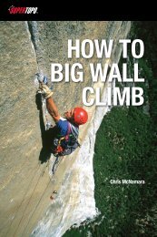
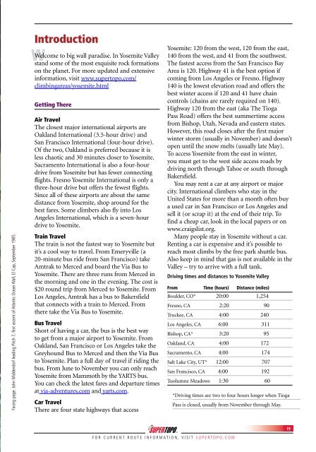
Facing page: John Middendorf leading Pitch 7, first ascent of Atlantic Ocean <strong>Wall</strong>, El Cap, September 1985.<br />
Introduction<br />
W Welcome to big wall paradise. In <strong>Yosemite</strong> Valley<br />
stand some of the most exquisite rock formations<br />
on the planet. For more updated and extensive<br />
information, visit www.supertopo.com/<br />
climbingareas/yosemite.html<br />
Getting <strong>The</strong>re<br />
Air Travel<br />
<strong>The</strong> closest major international airports are<br />
Oakland International (3.5-hour drive) and<br />
San Francisco International (four-hour drive).<br />
Of the two, Oakland is preferred because it is<br />
less chaotic and 30 minutes closer to <strong>Yosemite</strong>.<br />
Sacramento International is also a four-hour<br />
drive from <strong>Yosemite</strong> but has fewer connecting<br />
flights. Fresno <strong>Yosemite</strong> International is only a<br />
three-hour drive but offers the fewest flights.<br />
Since all of these airports are about the same<br />
distance from <strong>Yosemite</strong>, shop around for the<br />
best fares. Some climbers also fly into Los<br />
Angeles International, which is a seven-hour<br />
drive to <strong>Yosemite</strong>.<br />
Train Travel<br />
<strong>The</strong> train is not the fastest way to <strong>Yosemite</strong> but<br />
it’s a cool way to travel. From Emeryville (a<br />
20-minute bus ride from San Francisco) take<br />
Amtrak to Merced and board the Via Bus to<br />
<strong>Yosemite</strong>. <strong>The</strong>re are three runs from Merced in<br />
the morning and one in the evening. <strong>The</strong> cost is<br />
$20 round trip from Merced to <strong>Yosemite</strong>. From<br />
Los Angeles, Amtrak has a bus to Bakersfield<br />
that connects with a train to Merced. From<br />
there take the Via Bus to <strong>Yosemite</strong>.<br />
Bus Travel<br />
Short of having a car, the bus is the best way<br />
to get from a major airport to <strong>Yosemite</strong>. From<br />
Oakland, San Francisco or Los Angeles take the<br />
Greyhound Bus to Merced and then the Via Bus<br />
to <strong>Yosemite</strong>. Plan a full day of travel if riding the<br />
bus. From June to November you can only reach<br />
<strong>Yosemite</strong> from Mammoth by the YARTS bus.<br />
You can check the latest fares and departure times<br />
at via-adventures.com and yarts.com.<br />
Car Travel<br />
<strong>The</strong>re are four state highways that access<br />
<strong>Yosemite</strong>: 120 from the west, 120 from the east,<br />
140 from the west, and 41 from the southwest.<br />
<strong>The</strong> fastest access from the San Francisco Bay<br />
Area is 120. Highway 41 is the best option if<br />
coming from Los Angeles or Fresno. Highway<br />
140 is the lowest elevation road and offers the<br />
best winter access if 120 and 41 have chain<br />
controls (chains are rarely required on 140).<br />
Highway 120 from the east (aka <strong>The</strong> Tioga<br />
Pass Road) offers the best summertime access<br />
from Bishop, Utah, Nevada and eastern states.<br />
However, this road closes after the first major<br />
winter storm (usually in November) and doesn’t<br />
open until the snow melts (usually late May).<br />
<strong>To</strong> access <strong>Yosemite</strong> from the east in winter,<br />
you must get to the west side access roads by<br />
driving north through Tahoe or south through<br />
Bakersfield.<br />
You may rent a car at any airport or major<br />
city. International climbers who stay in the<br />
United States for more than a month often buy<br />
a used car in San Francisco or Los Angeles and<br />
sell it (or scrap it) at the end of their trip. <strong>To</strong><br />
find a cheap car, look in the local papers or on<br />
www.craigslist.org.<br />
Many people stay in <strong>Yosemite</strong> without a car.<br />
Renting a car is expensive and it’s possible to<br />
reach most climbs by the free park shuttle bus.<br />
Also keep in mind that gas is not available in the<br />
Valley – try to arrive with a full tank.<br />
Driving times and distances to <strong>Yosemite</strong> Valley<br />
From Time (hours) Distance (miles)<br />
Boulder, CO* 20:00 1,254<br />
Fresno, CA 2:20 90<br />
Truckee, CA 4:00 240<br />
Los Angeles, CA 6:00 311<br />
Bishop, CA* 3:20 95<br />
Oakland, CA 4:00 172<br />
Sacramento, CA 4:00 174<br />
Salt Lake City, UT* 12:00 707<br />
San Francisco, CA 4:00 192<br />
Tuolumne Meadows 1:30 60<br />
*Driving times are two to four hours longer when Tioga<br />
Pass is closed, usually from November through May.<br />
FOR CURRENT ROUTE INFORMATION, VISIT SUPERTOPO.COM<br />
11