

annexc - Newmont Mining Corporation
annexc - Newmont Mining Corporation
annexc - Newmont Mining Corporation

Create successful ePaper yourself
Turn your PDF publications into a flip-book with our unique Google optimized e-Paper software.
Annex C4 – Water Resources Supplemental Information C4 - 5<br />
SW-21 (PRA-1): Pra River at Praso Kuma (drainage area = 875 km 2 )<br />
� Feb-June 2004 flow measurements = 0.066 to 3.66 m 3 /sec<br />
� Minimum flow in May 2007 was zero m 3 /sec<br />
� Peak flows in September 2007 = 60 m 3 /sec, with sustained flows >10 m 3 /sec<br />
� Calculated bankfull discharge = 62 m 3 /sec<br />
SW-27 (PRA-2): Pra River at Ofoase-Praso Bridge (drainage area = 2,045 km 2 )<br />
� 1991-1999 flow measurements = 0 to 107 m 3 /sec<br />
� Minimum flow in May 2007 was zero m 3 /sec<br />
� Peak flows in September-October = 80 m 3 /sec, with sustained flows >20 m 3 /sec<br />
� Calculated bankfull discharge = 94 m 3 /sec<br />
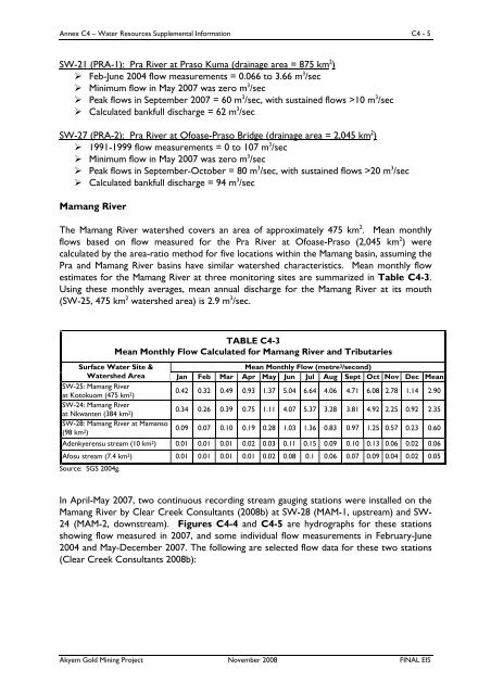
Mamang River<br />
The Mamang River watershed covers an area of approximately 475 km 2 . Mean monthly<br />
flows based on flow measured for the Pra River at Ofoase-Praso (2,045 km 2 ) were<br />
calculated by the area-ratio method for five locations within the Mamang basin, assuming the<br />
Pra and Mamang River basins have similar watershed characteristics. Mean monthly flow<br />
estimates for the Mamang River at three monitoring sites are summarized in Table C4-3.<br />
Using these monthly averages, mean annual discharge for the Mamang River at its mouth<br />
(SW-25, 475 km 2 watershed area) is 2.9 m 3 /sec.<br />
TABLE C4-3<br />
Mean Monthly Flow Calculated for Mamang River and Tributaries<br />
Mean Monthly Flow (metre3/second) Surface Water Site &<br />
Watershed Area Jan Feb Mar Apr May Jun Jul Aug Sept Oct Nov Dec Mean<br />
SW-25: Mamang River<br />
at Kotokuom (475 km2) 0.42 0.32 0.49 0.93 1.37 5.04 6.64 4.06 4.71 6.08 2.78 1.14 2.90<br />
SW-24: Mamang River<br />
at Nkwanten (384 km2) 0.34 0.26 0.39 0.75 1.11 4.07 5.37 3.28 3.81 4.92 2.25 0.92 2.35<br />
SW-28: Mamang River at Mamanso<br />
(98 km2) 0.09 0.07 0.10 0.19 0.28 1.03 1.36 0.83 0.97 1.25 0.57 0.23 0.60<br />
Adenkyerensu stream (10 km2) 0.01 0.01 0.01 0.02 0.03 0.11 0.15 0.09 0.10 0.13 0.06 0.02 0.06<br />
Afosu stream (7.4 km2) Source: SGS 2004g.<br />
0.01 0.01 0.01 0.01 0.02 0.08 0.1 0.06 0.07 0.09 0.04 0.02 0.05<br />
In April-May 2007, two continuous recording stream gauging stations were installed on the<br />
Mamang River by Clear Creek Consultants (2008b) at SW-28 (MAM-1, upstream) and SW-<br />
24 (MAM-2, downstream). Figures C4-4 and C4-5 are hydrographs for these stations<br />
showing flow measured in 2007, and some individual flow measurements in February-June<br />
2004 and May-December 2007. The following are selected flow data for these two stations<br />
(Clear Creek Consultants 2008b):<br />
Akyem Gold <strong>Mining</strong> Project November 2008 FINAL EIS


