

introduction - Ministry of Environment and Forests
introduction - Ministry of Environment and Forests
introduction - Ministry of Environment and Forests

You also want an ePaper? Increase the reach of your titles
YUMPU automatically turns print PDFs into web optimized ePapers that Google loves.
Foreword<br />
Preface<br />
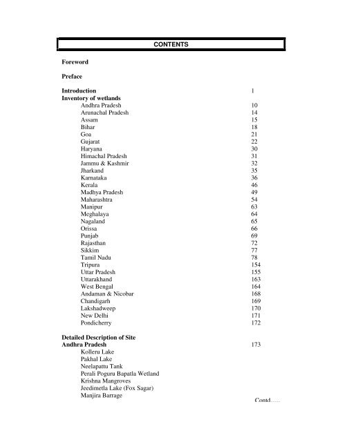
CONTENTS<br />
Introduction 1<br />
Inventory <strong>of</strong> wetl<strong>and</strong>s<br />
Andhra Pradesh 10<br />
Arunachal Pradesh 14<br />
Assam 15<br />
Bihar 18<br />
Goa 21<br />
Gujarat 22<br />
Haryana 30<br />
Himachal Pradesh 31<br />
Jammu & Kashmir 32<br />
Jhark<strong>and</strong> 35<br />
Karnataka 36<br />
Kerala 46<br />
Madhya Pradesh 49<br />
Maharashtra 54<br />
Manipur 63<br />
Meghalaya 64<br />
Nagal<strong>and</strong> 65<br />
Orissa 66<br />
Punjab 69<br />
Rajasthan 72<br />
Sikkim 77<br />
Tamil Nadu 78<br />
Tripura 154<br />
Uttar Pradesh 155<br />
Uttarakh<strong>and</strong> 163<br />
West Bengal 164<br />
Andaman & Nicobar 168<br />
Ch<strong>and</strong>igarh 169<br />
Lakshadweep 170<br />
New Delhi 171<br />
Pondicherry 172<br />
Detailed Description <strong>of</strong> Site<br />
Andhra Pradesh 173<br />
Kolleru Lake<br />
Pakhal Lake<br />
Neelapattu Tank<br />
Perali Poguru Bapatla Wetl<strong>and</strong><br />
Krishna Mangroves<br />
Jeedimetla Lake (Fox Sagar)<br />
Manjira Barrage<br />
Contd…..
Hussain Sagar Lake<br />
Lower Manair Reservoir<br />
Coringa Wildlife Sanctuary<br />
Kadam Reservoir<br />
Mid-Pennar Reservoir<br />
Musi Reservoir<br />
Singur Reservoir<br />
Wyra Reservoir<br />
Somasila Reservoir<br />
Srisailam Reservoir<br />
Arunachal Pradesh 189<br />
Wetl<strong>and</strong>s in Namdapha National Park<br />
Wetl<strong>and</strong>s in Mahao (Mehao) Sanctuary<br />
Wetl<strong>and</strong>s in Lali Sanctuary<br />
Assam 192<br />
Deepor Beel<br />
Beels <strong>of</strong> Assam<br />
Sareswar Beel<br />
Dibru Floodplain<br />
Sone Lake<br />
Wetl<strong>and</strong>s in Kaziranga National Park<br />
Bihar 206<br />
Kawar Lake<br />
Khabartal Lake<br />
Masanjore Reservoir<br />
Reservoirs <strong>of</strong> Chota Nagpur Plateau<br />
Chaurs <strong>of</strong> North Bihar And West Bengal<br />
Goa 213<br />
Chorao Isl<strong>and</strong><br />
Carambolim Lake<br />
M<strong>and</strong>ovi – Zuari Estuarine Complex<br />
Gujarat 216<br />
Great Rann <strong>of</strong> Kachchh<br />
Nalsarovar Lake <strong>and</strong> Surendranagar Reservoirs<br />
Little Rann <strong>of</strong> Kachchh<br />
Southern Gulf <strong>of</strong> Kachchh<br />
Wetl<strong>and</strong>s <strong>of</strong> Kachchh Peninusla<br />
N<strong>and</strong>a Isl<strong>and</strong><br />
Gulf <strong>of</strong> Khambhat<br />
Khijadia Lakes<br />
Kankavati <strong>and</strong> Sapda Dams<br />
Pariej <strong>and</strong> Kaneval Reservoirs<br />
Ajwa, Vadhw<strong>and</strong>a <strong>and</strong> Pavagadh Lakes<br />
Wetl<strong>and</strong>s <strong>of</strong> Sabarkanta <strong>and</strong> Banaskanta District<br />
Wetl<strong>and</strong>s <strong>of</strong> Central <strong>and</strong> Eastern Saurashtra<br />
Contd…..
Haryana 238<br />
Sultanpur Jheels<br />
Himachal Pradesh 240<br />
Renuka Wetl<strong>and</strong><br />
P<strong>and</strong>oh Reservoir<br />
Chamera Reservoir<br />
Ch<strong>and</strong>ertal Lake<br />
Pong Dam Lake<br />
Jammu & Kashmir 256<br />
Wular Lake<br />
Dal Lake<br />
Anchar Lake<br />
Surinsar-Mansar Lakes<br />
Mirgund Lake<br />
Pangong Tso<br />
Hokera Wetl<strong>and</strong><br />
Tsomoriri<br />
Chushul Marshes<br />
Shallabugh Lake <strong>and</strong> Marshes<br />
Some Typical Wetl<strong>and</strong>s <strong>of</strong> Kashmir<br />
Haigam Rakh<br />
Tso Kar Basin<br />
Ahansar <strong>and</strong> Waskursar Lakes<br />
Karnataka 285<br />
Byramangala Reservoir<br />
Markonahalli Reservoir<br />
Linganamakki Reservoir<br />
Ranganthittoo Wildlife Sanctuary<br />
Maddur Lake<br />
Kerala 290<br />
Ashtamudi Wetl<strong>and</strong><br />
Parambikulam Dam<br />
Sasthamkotta Lake<br />
Vembanad-Kol Wetl<strong>and</strong><br />
Azhinhillam Wetl<strong>and</strong><br />
Kuttanad Wetl<strong>and</strong><br />
Periyar Lake<br />
Kumarakom Mangrove<br />
Veli-Aukulam Lake<br />
Kuttiadi Lake<br />
Mangalavanam Mangrove<br />
Pudu Vyppu Mangrove Forest<br />
Peechi Dam Reservoir<br />
Contd…..
Madhya Pradesh 312<br />
Bhoj Wetl<strong>and</strong><br />
Dihaila Jheel<br />
Gopalpura Tank<br />
Chiklod Lake<br />
Ch<strong>and</strong>pata Lake<br />
Bargi Reservoir<br />
Barna Reservoir<br />
Dahod Reservoir<br />
G<strong>and</strong>hisagar Reservoir<br />
Halali Reservoir<br />
Kolar Reservoir<br />
Kerwa Reservoir<br />
Ravishankar Sagar Reservoir<br />
Sampna Reservoir<br />
Sagar Lake<br />
Tawa Reservoir<br />
Sarni Reservoir<br />
Shahpura Lake<br />
Maharashtra 338<br />
Bhategaon Dam<br />
Jagatunga Samudra Reservoir<br />
Panzara Dam<br />
Jayakawadi Reservoir<br />
Siddhewadi Reservoir<br />
Ped Reservoir<br />
Dhom Reservoir<br />
Ambedkar Tank<br />
Ekruk Reservoir<br />
Rankala Lake<br />
Hingni Reservoir<br />
Hadi Mangrove Wetl<strong>and</strong><br />
Jawalgaon Reservoir<br />
Shambhu Lake<br />
Yamai Lake<br />
Ujjini Reservoir<br />
Nathsagar Reservoir<br />
Wadali Lake<br />
Yeldari Reservoir<br />
N<strong>and</strong>ur Madhameshwar<br />
Pune-Sholapur Reservoirs<br />
Ratnagiri Mangroves<br />
Manipur 355<br />
Loktak Lake<br />
Sanapat Lake<br />
Keibul Lamjao National Park<br />
Phumlen, Kharung, <strong>and</strong> Ikop Lakes<br />
Contd…..
Meghalaya 362<br />
Ward’s Lake<br />
Umiam Reservoir<br />
Orissa 365<br />
Bhitarkanika Mangrove<br />
Chilka Lake<br />
Satkoshia Gorge Sanctuary<br />
Hirakud Reservoir<br />
Chitrakonda Dam<br />
Rengali Dam<br />
Upper Kolab Dam<br />
Punjab 380<br />
Ropar Reservoir<br />
Januari Reservoir<br />
Dholbaha Reservoir<br />
Harike Lake<br />
Kanjli<br />
Rajasthan 403<br />
Sambhar Lake<br />
Phulera, <strong>and</strong> Didwana Salt Lakes<br />
Jaisam<strong>and</strong> Lake<br />
Keoladeo National Park<br />
Gambhiri Reservoir<br />
Jawai Reservoir<br />
Sardar Sam<strong>and</strong> Reservoir<br />
Kothari Reservoir<br />
Khari Reservoir<br />
N<strong>and</strong>sam<strong>and</strong> Reservoir<br />
Som Kamla Amba Reservoir<br />
Orai Reservoir<br />
Udaisagar Reservoir<br />
West Banas Reservoir<br />
Sikkim 424<br />
Sacred Khechopalri Lake<br />
Tamil Nadu 425<br />
Muthupet Mangrove<br />
Pulicat Lake<br />
Pichavaram Mangrove<br />
Point Calimere Wildlife <strong>and</strong> Bird Sanctuary<br />
Chembarambakam Tank<br />
Kaliveli Tank<br />
Sathanur Reservoir<br />
Adyar Estuary<br />
Bhavanisagar Reservoir<br />
Contd…..
Gulf <strong>of</strong> Mannar Marine National Park<br />
Wetl<strong>and</strong>s <strong>of</strong> Nilgiri District<br />
Siruthavur Tank<br />
Vedanthangal <strong>and</strong> Karikili Tanks<br />
Vettakudi-Karavetti Reservoir<br />
Wetl<strong>and</strong> in Madurai Agricultural College <strong>and</strong> Research Institute Campus<br />
Vettangudi Tanks<br />
Karungulam <strong>and</strong> Sengulam Tanks<br />
Puthupalli Alam Swamp<br />
Tripura 468<br />
Rudrasagar Lake<br />
Uttar Pradesh 471<br />
Manjhira Impoundment at Girija Barrage<br />
Pyagpur <strong>and</strong> Sitadwar Jheels<br />
Nawabgani Priyadarshani Bird Sanctuary<br />
Dahar <strong>and</strong> Sauj (Soj) Jheels<br />
Chhata Lakes<br />
Jheels in the Vicinity <strong>of</strong> Haidergarh<br />
Nainital Lake<br />
Baghla Reservoir<br />
Surha Wetl<strong>and</strong><br />
Matatilla Reservoir<br />
Wetl<strong>and</strong>s <strong>of</strong> Eastern Uttar Pradesh<br />
Upper Ganga River (Brijghat to Narora Stretch)<br />
West Bengal 488<br />
Sundarbans Mangrove<br />
East Calcutta Wetl<strong>and</strong>s<br />
Brace Bridge Wetl<strong>and</strong>s<br />
Wetl<strong>and</strong>s <strong>of</strong> Hugli District<br />
Wetl<strong>and</strong>s <strong>of</strong> Haora District<br />
Purbasthali Lake<br />
Wetl<strong>and</strong>s in Jaldapara Wildlife Sanctuary<br />
Andaman & Nicobar 516<br />
Mangrove Wetl<strong>and</strong>s <strong>of</strong> Middle Andaman<br />
New Delhi 517<br />
Jamuna River near Delhi<br />
Pondicherry 519<br />
Ousteri Lake<br />
References 524
W<br />
INTRODUCTION<br />
etl<strong>and</strong>s are among the most productive ecosystems in the world,<br />
comparable to rain forests <strong>and</strong> coral reefs. They are repositories <strong>of</strong><br />
diverse species <strong>of</strong> microbes, plants, insects, amphibians, reptiles, birds, fishes <strong>and</strong><br />
mammals. The ideal climate, l<strong>and</strong>scape (topology), geology, movement <strong>and</strong><br />
abundance <strong>of</strong> water help the flora <strong>and</strong> fauna inhabiting the wetl<strong>and</strong> ecosystems.<br />
Wetl<strong>and</strong>s are “biological supermarkets”, which provide immense food that attracts<br />
many animal species for completion <strong>of</strong> their life-cycle. The decaying dead plants <strong>and</strong><br />
animals in the wetl<strong>and</strong>s are converted by bacteria into organic matter (detritus) that<br />
are fed by many small aquatic insects, shellfishes <strong>and</strong> small fishes that are food for<br />
larger predatory fishes, reptiles, amphibians, birds, <strong>and</strong> mammals.<br />
What are Wetl<strong>and</strong>s?<br />
Wetl<strong>and</strong>s are transitional zones between terrestrial <strong>and</strong> aquatic systems where the<br />
water table is usually at or near the surface or the l<strong>and</strong> is covered by shallow water.<br />
‘Wetl<strong>and</strong>’ is a generic term for water bodies <strong>of</strong> various types, <strong>and</strong> include diverse<br />
hydrological entities, namely, lakes, marshes, swamps, estuaries, tidal flats, river<br />
flood plains, peatl<strong>and</strong>s, shallow ponds, etc. Wetl<strong>and</strong>s must have one or more <strong>of</strong> the<br />
three attributes viz. atleast periodically, the l<strong>and</strong> supports predominantly hydrophytes;<br />
the substrate has predominantly undrained hydric soil; <strong>and</strong> the substrate is non soil,<br />
saturated with water or covered by shallow water at sometime during the growing<br />
season <strong>of</strong> each year.<br />
Definitions <strong>of</strong> Wetl<strong>and</strong>s<br />
The definitions, by Cowardin et al. (1979), are widely accepted by wetl<strong>and</strong> scientists<br />
<strong>of</strong> United States <strong>and</strong> are also used in India (Mitsch <strong>and</strong> Gosselink, 1993). According<br />
to Cowardin et al. (1979), wetl<strong>and</strong>s are zones (l<strong>and</strong>s) where saturation with water is<br />
the key factor determining the nature <strong>of</strong> soil development <strong>and</strong> the types <strong>of</strong> plant <strong>and</strong><br />
animal communities living in the soil <strong>and</strong> on its surface. Wetl<strong>and</strong>s differ widely,<br />
regionally with different soils types, topography, climate, hydrology, water chemistry,<br />
vegetation <strong>and</strong> other factors including human disturbance.<br />
About wetl<strong>and</strong>s, it is very relevant to quote R. Brown in “Encyclopedia <strong>of</strong> Life<br />
Science”, 1996 which reads, “The word wetl<strong>and</strong>s seems to contradict itself. How can<br />
something that is wet really be considered l<strong>and</strong>? Why is wetl<strong>and</strong>s, simply not a lake or<br />
a stream? Wetl<strong>and</strong>s are the places where the two great natural components that cover<br />
our Earth-l<strong>and</strong> <strong>and</strong> water- wet <strong>and</strong> mingle to support life forms that are <strong>of</strong>ten different<br />
from those that dwell only on l<strong>and</strong> or only in water”.<br />
The World Book Encyclopedia (1996), USA, defines “Wetl<strong>and</strong>s is an area <strong>of</strong> l<strong>and</strong><br />
where the water level remains near or above the surface <strong>of</strong> the ground for most <strong>of</strong> the<br />
year”. The term “Aquatic”, according to Oxford Advanced Learner’s Dictionary<br />
(Encyclopedia Edition, 1992) refers to plants <strong>and</strong> animals, etc. growing or living in or<br />
near water: The Chambers Dictionary (New Edition, 1993) adopts the same<br />
definition. Both these dictionaries refer to marshy areas as wetl<strong>and</strong> (a marsh being<br />
defined as low lying wetl<strong>and</strong>, swamp or fen). Ralph A. Luken (1976) in “Preservation<br />
versus Development”, defines “The term wetl<strong>and</strong> is synonymous with bay l<strong>and</strong>s <strong>and</strong><br />
includes submerged l<strong>and</strong>, tide l<strong>and</strong>, swamp <strong>and</strong> over-flow l<strong>and</strong>”.
As such, it seems, the experts do not specifically define wetl<strong>and</strong>s as a very distinct<br />
ecosystem <strong>and</strong> consider such l<strong>and</strong> synonymous with aquatic substratum or in other<br />
words ‘The Wetl<strong>and</strong> Ecology’ is therefore synonymous with ‘Aquatic Ecology.’<br />
Mitsch <strong>and</strong> Gosselink (1986) the frontline wetl<strong>and</strong> scientists observe, “A precise<br />
wetl<strong>and</strong> definition that is satisfactory to all users has not yet been developed, because<br />
the definition <strong>of</strong> wetl<strong>and</strong> depends on the objectives <strong>and</strong> field <strong>of</strong> interest <strong>of</strong> the users.<br />
Different definitions can result from the geologist, soil scientist, hydrologist,<br />
biologist, ecologist, sociologist, economist, political scientist <strong>and</strong> public health<br />
scientist.”<br />
Wetl<strong>and</strong> as special niche <strong>of</strong> the l<strong>and</strong>scape caught the eyes <strong>of</strong> the ecologists <strong>and</strong><br />
biologists only in late 1960s. The Ramsar Convention (1971), the first global<br />
Conservation Convention brought this subject to the international arena <strong>and</strong> framed<br />
universally accepted wetl<strong>and</strong>s, which reads: “areas <strong>of</strong> marsh, fen, peatl<strong>and</strong> or water,<br />
whether natural or artificial, permanent or temporary with water i.e., static or flowing,<br />
fresh, brackish or salt, including areas <strong>of</strong> marine water the depth <strong>of</strong> which at low tide<br />
does not exceed six meters”. As such it becomes different to clacify other aquatic<br />
bodies in to wetl<strong>and</strong> group. In order to prepare a status <strong>of</strong> wetl<strong>and</strong>s in United States,<br />
the United State Department <strong>of</strong> Interior, Fish <strong>and</strong> Wildlife Service Authority,<br />
however, adopted the definitions <strong>of</strong> Cowardin (1979) which is given under:<br />
“The wetl<strong>and</strong>s are l<strong>and</strong>s transitional between terrestrial <strong>and</strong> aquatic systems where the<br />
water table is usually at or near the surface or the l<strong>and</strong> is covered by shallow water.”<br />
Moreover, this definition includes several attributes which are:<br />
• At least periodically the l<strong>and</strong> must support predominantly hydrophytes.<br />
• The substrate is predominantly undrained hydric soil.<br />
• The substrate is non-soil <strong>and</strong> is saturated with water or covered by shallow<br />
water sometime during the growing season <strong>of</strong> each year.<br />
This definition emphasises three key attributes <strong>of</strong> wetl<strong>and</strong>s: (i) hydrology –the degree<br />
<strong>of</strong> flooding or soil saturation: (ii) wetl<strong>and</strong> vegetation (hydrophytes); <strong>and</strong> (iii) hydric<br />
soils. This definition has been broadly followed as it specifies various attributes <strong>of</strong><br />
wetl<strong>and</strong>s. This definition does not contradict IUCN’s definition but only specifies the<br />
parameters to be used for identification.<br />
The <strong>Ministry</strong> <strong>of</strong> <strong>Environment</strong> & <strong>Forests</strong> (Govt. <strong>of</strong> India) has adopted the definition <strong>of</strong><br />
Wetl<strong>and</strong>s which is given by the Convention on wetl<strong>and</strong>s <strong>of</strong> International Importance<br />
(Ramsar).<br />
Classification <strong>of</strong> Wetl<strong>and</strong>s by IUCN<br />
IUCN identified a total <strong>of</strong> 39 categories <strong>of</strong> wetl<strong>and</strong>s <strong>of</strong> which 30 are natural wetl<strong>and</strong>s<br />
<strong>and</strong> nine man-made. In it there are seven l<strong>and</strong>scape units viz., estuaries, open coasts,<br />
flood plains, freshwater marshes, lakes, peatl<strong>and</strong>s <strong>and</strong> swamp forests. Freshwater<br />
wetl<strong>and</strong>s are haors, beels, jheels, oxbow lakes <strong>and</strong> flood plains. The table below<br />
shows the classification <strong>of</strong> wetl<strong>and</strong>s.<br />
Wetl<strong>and</strong>s Classification (Dugon 1990)<br />
Salt Water<br />
Marine 1. Subtidal (i) Permanent unvegetated shallow waters less than<br />
6m deph at low tide, including sea bays, straits.
(ii) Subtidal aquatic vegetation including kelp beds,<br />
sea grasses, tropical marine meadows.<br />
(iii) Coral reefs.<br />
2. Intertidal (i) Rocky marine shores, including cliffs <strong>and</strong> rocky<br />
shores.<br />
(ii) Shores <strong>of</strong> mobile stones <strong>and</strong> shingle.<br />
(iii) Intertidal mobile unvegetated mud, s<strong>and</strong> or salt<br />
flats.<br />
(iv) Intertidal vegetated sediments, including salt<br />
marshes <strong>and</strong> mangroves, or sheltered coasts.<br />
Estuarine 1. Subtidal (i) Estuarine waters; permanent waters <strong>of</strong> estuaries<br />
<strong>and</strong> estuarine systems <strong>of</strong> deltas.<br />
2. Intertidal (i) Intertidal mud, s<strong>and</strong> or salt flats, with limited<br />
vegetation.<br />
(ii) Intertidal marshes, including salt marshes, salt<br />
meadows, saltings, raised salt marshes, tidal<br />
brackish <strong>and</strong> freshwater marshes.<br />
(iii) Intertidal forested wetl<strong>and</strong>s, including mangrove<br />
swamp, Nypa swamp, tidal freshwater swamp<br />
forest.<br />
Lagoon (i) Brackish to saline lagoons with one or more<br />
relatively narrow connections with the sea.<br />
Salt Lake (i) Permanent <strong>and</strong> seasonal, brackish, saline or<br />
alkaline lakes, flats <strong>and</strong> marshes.<br />
Freshwater<br />
Riverine Perennial (i) Permanent rivers <strong>and</strong> streams, including<br />
waterfalls.<br />
(ii) Inl<strong>and</strong> deltas.<br />
Temporary (i) Seasonal <strong>and</strong> irregular rivers <strong>and</strong> streams.<br />
(ii) Riverine floodplains, including river flats,<br />
flooded river basins, seasonally flooded<br />
grassl<strong>and</strong>.<br />
Lacustrine Permanent (i) Permanent freshwater lakes (>8 ha), including<br />
shores subject to seasonal or irregular<br />
inundation.<br />
(ii) Permanent freshwater ponds (8 ha), including<br />
floodplain lakes.<br />
Palustrine Emergent (i) Permanent freshwater marshes <strong>and</strong>swamps on<br />
inorganic soils, with emergent vegetation whose
ases lie below the water table for at least most<br />
<strong>of</strong> the growing season.<br />
(ii) Permanent peat-forming freshwater swamps,<br />
including tropical upl<strong>and</strong> valley swamps<br />
dominated by Papyrus or Typha.<br />
(iii) Seasonal freshwater marshes on inorganic soil,<br />
including sloughs, potholes, seasonally flooded<br />
meadows, sedge marshes, <strong>and</strong> dambos.<br />
(iv) Peatl<strong>and</strong>s, including acidophilous,<br />
ombrogenous, or soligenous mires covered by<br />
moss, herbs <strong>of</strong> dwarf shrub vegetation, <strong>and</strong> fens<br />
<strong>of</strong> all types.<br />
(v) Alpine <strong>and</strong> polar wetl<strong>and</strong>s, including seasonally<br />
flooded meadows moistened by temporary<br />
waters from snowmelt.<br />
(vi) Freshwater springs <strong>and</strong> oases with surrounding<br />
vegetation.<br />
(vii) Volcanic fumaroles continually moistened by<br />
emerging <strong>and</strong> condensing water vapour.<br />
Forested (i) Shrub swamps, including shrub-dominated<br />
freshwater marsh, shrub carr <strong>and</strong> thickets, on<br />
inorganic soils.<br />
Man-Made Wetl<strong>and</strong>s<br />
(ii) Freshwater swamp forest, including seasonally<br />
flooded forest, wooded swamps on inorganic<br />
soils.<br />
(iii) Forested peatl<strong>and</strong>s, including peat swamp<br />
forest.<br />
Aquaculture/Mariculture (i) Aquaculture ponds, including fish ponds <strong>and</strong><br />
shrimp ponds.<br />
Agriculture (i) Ponds, including farm ponds, stock ponds,<br />
small tanks.<br />
(ii) Irrigated l<strong>and</strong> <strong>and</strong> irrigation channels, including<br />
fields, canals <strong>and</strong> ditches.<br />
(iii) Seasonally flooded arable l<strong>and</strong>.<br />
Salt Exploitation (i) Salt pans <strong>and</strong> salines<br />
Urban/Industrial (i) Excavations, including gravel pits, borrow pits<br />
<strong>and</strong> mining pools.<br />
(ii) Wastewater treatment areas, including sewage<br />
farms, settling ponds <strong>and</strong> oxidation basins.
Water-Storage Areas (i) Reservoirs holding water for irrigation <strong>and</strong>/or<br />
human consumption with a pattern <strong>of</strong> gradual,<br />
seasonal, draw down <strong>of</strong> water level.<br />
Role <strong>of</strong> Wetl<strong>and</strong>s<br />
(ii) Hydro-dams with regular fluctuations in water<br />
level on a weekly or monthly basis.<br />
Wetl<strong>and</strong>s directly or indirectly have an enormous ecological, economic, commercial<br />
<strong>and</strong> socio-economic importance <strong>and</strong> values. Such l<strong>and</strong>s constitute very rich<br />
biodiversity <strong>of</strong> flora <strong>and</strong> fauna <strong>of</strong> important local, natural <strong>and</strong> regional significance.<br />
Two significant parameters identified by various wetl<strong>and</strong>s scientists are - (i)<br />
Functions <strong>and</strong> (ii) Values.<br />
The principal functions are – ground water recharge <strong>and</strong> discharge, storage <strong>of</strong> water,<br />
storage <strong>of</strong> flood water, shoreline stabilization, erosion control, sediment trapping,<br />
nutrient retention <strong>and</strong> removal, support for food chains, fisheries production, habitat<br />
for wildlife, recreation, natural heritage values, biomass production, water transport,<br />
bio-diversity preservation <strong>and</strong> microclimate stabilization.<br />
Coastal wetl<strong>and</strong>s play a positive role in recovering phosphates <strong>and</strong> nitrates from<br />
estuarine water <strong>and</strong> release oxygen; consequently it reduces nutrient load <strong>and</strong><br />
biochemical oxygen dem<strong>and</strong> (BOD) <strong>of</strong> coastal water. These wetl<strong>and</strong>s act as natural<br />
protection zone for densely habitated inl<strong>and</strong> region; specially the wetl<strong>and</strong> vegetation<br />
can be a positive buffer against cyclonic storm.<br />
Wetl<strong>and</strong>s in India<br />
The wetl<strong>and</strong>s are increasingly facing several anthropogenic pressures, due to rapidly<br />
exp<strong>and</strong>ing human population, large scale changes in l<strong>and</strong> use/l<strong>and</strong> cover <strong>and</strong><br />
burgeoning development projects <strong>and</strong> improper use <strong>of</strong> watersheds have all caused a<br />
substantial decline <strong>of</strong> wetl<strong>and</strong> resources <strong>of</strong> the country. Absence <strong>of</strong> reliable <strong>and</strong><br />
updated information <strong>and</strong> data on extent <strong>of</strong> wetl<strong>and</strong>s, their conservation values <strong>and</strong><br />
socioeconomic importance has greatly hampered for development <strong>of</strong> policy,<br />
legislation <strong>and</strong> administrative interventions by the state.<br />
For long-term conservation planning <strong>of</strong> wetl<strong>and</strong>s, spatial data <strong>and</strong> information are<br />
required for any intervention. Wetl<strong>and</strong> ecosystem in India constitutes an integral part<br />
<strong>of</strong> cultural <strong>and</strong> biodiversity l<strong>and</strong>scape. It is estimated that 3.5 million hectares <strong>of</strong><br />
wetl<strong>and</strong>s exist in the country according to 1992-1993 study by the Space Application<br />
Centre. However, this information pertains to wetl<strong>and</strong>s above 56 ha in size. Previous<br />
research works on wetl<strong>and</strong> conservation in the country has shown conclusively that<br />
micro wetl<strong>and</strong>s or satellite wetl<strong>and</strong>s around a bigger wetl<strong>and</strong> act as a constellation <strong>of</strong><br />
habitat mosaic for resident <strong>and</strong> migratory waterfowl. This is <strong>of</strong> special importance for<br />
inl<strong>and</strong> wetl<strong>and</strong> habitats in the flyways <strong>of</strong> migratory birds in the Indo-Gangetic plains<br />
<strong>and</strong> in Deccan Peninsula. Often, the size <strong>of</strong> these micro wetl<strong>and</strong>s is much smaller than<br />
50ha. Therefore, there is a great need to map wetl<strong>and</strong>s <strong>of</strong> smaller size less than 50ha.<br />
Spatial information on wetl<strong>and</strong> resources is a critical <strong>and</strong> an urgently needed for an<br />
effective conservation <strong>of</strong> the important ecosystem.<br />
For a country like India, with its vast biological <strong>and</strong> cultural diversity, a<br />
comprehensive use <strong>of</strong> remote sensing, GIS <strong>and</strong> other related technologies will be <strong>of</strong><br />
great use in conservation. Classifying <strong>and</strong> mapping wetl<strong>and</strong>s based on<br />
geomorphology, water quality <strong>and</strong> other biological attributes can lead to qualitative
assessment. Results obtained could be used in planning, inventorying <strong>and</strong> monitoring<br />
wetl<strong>and</strong>s in the country.<br />
Wetl<strong>and</strong> resources exhibit significant ecological diversity, primarily because <strong>of</strong><br />
variability in climatic conditions <strong>and</strong> changing topography. Unfortunately, many such<br />
areas have been converted for agriculture, industry or settlements. A great number <strong>of</strong><br />
wetl<strong>and</strong>s have been affected by industrial effluents, discharge <strong>of</strong> sewage, household<br />
wastes <strong>and</strong> sedimentation due to ecological degradation in catchment areas.<br />
Realising the crucial role <strong>of</strong> the wetl<strong>and</strong> ecosystems in flood control, recharging <strong>of</strong><br />
aquifers, regulating water quality, reducing sediment load <strong>and</strong> pollution abatement, its<br />
potential for aquaculture <strong>and</strong> as breeding ground for waterfowls, the <strong>Ministry</strong> <strong>of</strong><br />
<strong>Environment</strong> <strong>and</strong> Forest (Govt. <strong>of</strong> India) constituted an Expert Group in 1983 for<br />
compiling information on the ecological status <strong>of</strong> wetl<strong>and</strong>s in the country. Earlier to<br />
this in 1972, a survey had been initiated to collect some basic information which was<br />
subsequently updated. Based on the analysis <strong>of</strong> the responses, the Directory <strong>of</strong><br />
wetl<strong>and</strong>s in India was published in 1990 by the <strong>Ministry</strong> <strong>of</strong> <strong>Environment</strong> & <strong>Forests</strong>.<br />
The present directory is updated mainly based on the information collected from<br />
various sources on the distribution <strong>and</strong> their status <strong>of</strong> wetl<strong>and</strong>s in India.<br />
This directory covers Inl<strong>and</strong> <strong>and</strong> Coastal water bodies like lakes, tanks, reservoirs,<br />
marshes, swamps, etc. The detailed information <strong>of</strong> wetl<strong>and</strong> site (geographical<br />
coordinates, general location <strong>of</strong> the site, nearest village, district <strong>and</strong> state); total area<br />
(ha); ecological category; abiotic <strong>and</strong> biotic factors; l<strong>and</strong> tenure; l<strong>and</strong> use;<br />
conservation measures taken; socio-economic values; disturbance <strong>and</strong> threats;<br />
pollution status are given in the State/ Union Territory-wise. In addition, detailed<br />
information available on few wetl<strong>and</strong> ecosystems <strong>and</strong> measures taken by the<br />
Government <strong>of</strong> India for conservation <strong>of</strong> wetl<strong>and</strong>s are also included.<br />
Based on the available information, the details <strong>of</strong> about 2,211 major <strong>and</strong> minor<br />
wetl<strong>and</strong>s have been given in the present directory. Efforts are also taken to collect<br />
more information <strong>and</strong> update the data which will be presented in the subsequent<br />
editions <strong>of</strong> the directory.
ANDHRA PRADESH<br />
S.No. Name <strong>of</strong> the Wetl<strong>and</strong> Name <strong>of</strong> the<br />
Nearest<br />
Village/Town<br />
Name <strong>of</strong> the<br />
District<br />
1 2 3 4<br />
NATURAL WETLANDS<br />
1 Araniar Reservoir - Chitoor<br />
2 Interu Swamps Bintumalli Krishna <strong>and</strong> West<br />
Godavari<br />
3 Kajam Reservoir Nimal Adilabad<br />
4 Kolleru Eluru Krishna & West<br />
Godavari<br />
5 *Kondakarla Lake Anakapalli Visakhapatnam<br />
6 Neelapattu Lake Neelapattu Nellore<br />
7 Nizamapatnam Nizamapatnam Guntur<br />
8 Pakhal Lake Ashok Nagar Warangal<br />
9 *Perali Poguru Bapatla Vijayawada, Guntur<br />
MAN-MADE WETLANDS<br />
10 *Athvelly Cheruvu Secundarabad -<br />
11 Badvel Tank Badvel -<br />
12 *Bibinagar Tank Bibinagar Hyderabad<br />
13 *Coringa Wildlife Rajahmundry -<br />
Sanctuary<br />
14 *Dabilpur Cheruvu Secundarabad -<br />
15 *Dhulapally Cheruvu Secundarabad -<br />
16 *Edulabad Reservoir - -<br />
17 *Gambhiramgedda Visakhapatnam -<br />
18 *Gundla Cheruvu Secundarabad -<br />
19 *Hussain Sagar Lake - Ranga Reddy<br />
20 *Indravati National Park<br />
(Wetl<strong>and</strong>s in)<br />
Pusnar -<br />
21 *Jeedimetla Lake Hyderabad Hyderabad<br />
(Fox Sagar)<br />
22 Jusi Reservoir Suryapet Kurnool<br />
23 *Kadam Reservoir Adilabad -<br />
24 *Kaziranga National park - Gauhati<br />
1. Total Geographical Area :<br />
2,75,06,800 ha.<br />
2. Forest Area<br />
ha. (23.20%)<br />
: 63,82,100
Latitude<br />
(N)<br />
Longitude<br />
(E)<br />
Area<br />
(ha.)<br />
Ecological<br />
Category<br />
5 6 7 8<br />
13° 16’ 79° 40’ 200.00 Freshwater<br />
16° 20’ 81° 15’ 2,651.00 Brackishwater<br />
19° 10’ 78° 43’ 25,000.00 Freshwater<br />
16° 32’ 81° 05’ 90,000.00 Freshwater<br />
17° 35’ 82° 59’ 650.00 Freshwater<br />
13° 45’ 80° 00’ 453.00 Brackishwater<br />
16° 10’ 80° 16’ 1,000.00 Brackishwater<br />
17° 40’ 79° 55’ 2,400.00 Freshwater<br />
15° 49’ 80° 27’ 1,500.00 Brackishwater<br />
17° 39’ 78° 29’ 28.00 Freshwater<br />
14° 40’ 79° 00’ 610.00 Freshwater<br />
17° 38’ 78° 46’ - Freshwater<br />
16° 27’ 82° 01 23,570.00 Brackishwater<br />
17° 40’ 78° 30’ 75.00 Freshwater<br />
17° 32’ 78° 27’ 26.00 Freshwater<br />
- - 244.31 Freshwater<br />
- - - Freshwater<br />
17° 31’ 78° 29’ 30.00 Freshwater<br />
17° 20’ 78° 30’ 710.00 Freshwater<br />
19° 00’ 81° 00’ - Freshwater<br />
18° 30’ 77° 30’ 4,700.00 Freshwater<br />
17° 10’ 79° 26’ 533.00 Freshwater<br />
19° 18’ - 2,474.00 Freshwater<br />
- - - Freshwater<br />
1 2 3 4<br />
25 *Krishna Mangrove Krishna Guntur<br />
26 Lower maniar Dam Karimnagar -<br />
27 *Madhapur Botanical Hyderabad Hyderabad<br />
Garden Lake<br />
28 *Manas National Park - Gauhati<br />
29 *Manjira Barrage Hyderabad Hyderabad<br />
30 *Manjiri Sanctuary - -<br />
31 *Medchal Pedda Cheruvu Secundarabad Nalgonda<br />
32 *Mehadrigedda Visakhapatnam
33 *Medchal Voora Cheruvu Secundarabad Nalgonda<br />
34 Mid-Pennar Reservoir Anantapur -<br />
35 *Minor Reservoir Shaikpet Hyderabad<br />
36 Mudasarlova Visakhapatnam -<br />
37 Musi Reservoir Nalgonda -<br />
38 *Nagarjuna Sagar M<strong>and</strong>i Gonda Nalgonda<br />
39 Nuthankal Cheruvu Secundarabad Nalgonda<br />
40 Pocharam Reservoir - Medak<br />
41 Poli Tank Rajampet -<br />
42 Porumamilla Porumamilla -<br />
43 Railapur Cheruvu Secundarabad Nalgonda<br />
44 Rendli Pakale Rendli Cuddapah<br />
45 *Saroornagar Lake - Hyderabad<br />
46 Singur Reservoir Medak -<br />
47 *Shathamraj Shaikpet -<br />
48 *Srisailam Reservoir Srisailam Cuddapah<br />
49 Somasila Reservoir Nellore Nellore<br />
50 Surla Devi Chaur Hazugudam Cuddapah<br />
51 *Tungabhadra Reservoir - -<br />
52 Ura Chaur Burugadda Karimnagar<br />
53 Wyra Reservoir Khamman -<br />
54 *Yerrakalva Reservoir - West Godavari<br />
5 6 7 8<br />
15° 45’ 80° 45’ 27,661.00 Brackishwater<br />
18° 15’ 78° 32’ 8,105.00 Freshwater<br />
- - - Freshwater<br />
- - 27,000.00 Freshwater<br />
17° 38’ 78° 05’ 2,000.00 Freshwater<br />
17°40’ 77°00’ 20,000.00 Freshwater<br />
17° 35’ 78° 29’ 24.00 Freshwater<br />
- - - Freshwater<br />
17° 35’ 78° 29’ 14.00 Freshwater<br />
14° 52’ - 1,703.00 Freshwater<br />
- - 25.00 Freshwater<br />
- - - Freshwater<br />
17° 14’ - 2,507.00 Freshwater<br />
16° 34’ 79° 10’ 28,474.00 Freshwater
- - 18.00 Freshwater<br />
18° 8’ 78° 10’ 20,000.00 Freshwater<br />
14° 10’ 79° 10’ 120.00 Freshwater<br />
15° 00’ 79° 00’ 750.00 Freshwater<br />
17° 37’ 78° 26’ 26.00 Freshwater<br />
- - 280.00 Freshwater<br />
17°22’ 78°22’ 41.00 Freshwater<br />
17° 45’ - 16,534.00 Freshwater<br />
- - 25.00 Freshwater<br />
16° 50’ 78° 00’ 61,404.00 Freshwater<br />
14° 29’ - 21,349.00 Freshwater<br />
- - 250.00 Freshwater<br />
- - 37,814.00 Freshwater<br />
- - 150.00 Freshwater<br />
17° 11’ - 1,626.00 Freshwater<br />
17°5’22’’ 81°15’22’’ 1,138.76 Freshwater
ARUNACHAL PRADESH<br />
ASSAM<br />
Name <strong>of</strong> the Wetl<strong>and</strong> Name<br />
<strong>of</strong> the<br />
Nearest<br />
Village/<br />
Town<br />
NATURAL WETLANDS<br />
Pakhui (Kameng &<br />
Pakke River System<br />
Name<br />
<strong>of</strong> the<br />
Distri<br />
ct<br />
2 3 4<br />
Rangap<br />
ara<br />
North/T<br />
ejpur<br />
Kame<br />
ng<br />
Talley Valley Hapoli Suban<br />
siri<br />
MAN-MADE WETLANDS<br />
*Lali Sanctuary<br />
(Wetl<strong>and</strong>s in)<br />
*Mahao (Mehao)<br />
Sanctuary (Wetl<strong>and</strong>s<br />
in)<br />
*Namdapha National<br />
Park (Wetl<strong>and</strong>s in)<br />
Name <strong>of</strong> the<br />
Wetl<strong>and</strong><br />
NATURAL WETLANDS<br />
Pasigha<br />
t<br />
Balipar<br />
a<br />
Dibruga<br />
rh<br />
Name <strong>of</strong><br />
the Nearest<br />
Village/To<br />
wn<br />
East<br />
Siang<br />
Diban<br />
g<br />
Valley<br />
Tirap<br />
Name<br />
<strong>of</strong> the<br />
District<br />
2 3 4
Amreng Beel Diphu Karbi<br />
Anglon<br />
g<br />
Andheri Beel Chatgano Kamru<br />
p<br />
Arimora Kohara Sibsaga<br />
r<br />
4. Total Geographical Area :<br />
83,74,300 ha.<br />
5. Forest Area<br />
ha. (61.55%)<br />
Latitude<br />
(N)<br />
Longit<br />
ude<br />
(E)<br />
Ar<br />
ea<br />
(ha<br />
.)<br />
Ecological<br />
Category<br />
5 6 7 8<br />
26° 50’ 92°<br />
00’<br />
28° 30’ 94°<br />
00’<br />
27° 53’ 95°<br />
23’<br />
28° 05’ 95°<br />
40’<br />
27° 23’ 96°<br />
15’<br />
Latitude<br />
(N)<br />
Longit<br />
ude<br />
(E)<br />
20,<br />
000<br />
.00<br />
200<br />
.00<br />
Ar<br />
ea<br />
(ha<br />
: 51,54,000<br />
Freshwater<br />
Freshwater<br />
- Freshwater<br />
- Freshwater<br />
- Freshwater<br />
1. Total Geographical Area :<br />
78,43,800 ha.<br />
2. Forest Area<br />
ha. (34.21%)<br />
: 26,83,200<br />
Ecological<br />
Category
.)<br />
5 6 7 8<br />
25° 50’ 93°<br />
25’<br />
26° 00’ 91°<br />
40’<br />
26° 40’ 93°<br />
25’<br />
150<br />
.00<br />
200<br />
.00<br />
168<br />
.00<br />
Brackishwater<br />
Freshwater<br />
Freshwater
Assam<br />
1 2 3 4<br />
4 Baguri Bor Baguri Sibsagar<br />
5 Ch<strong>and</strong> Dubi Beel Pabsabari Kamrup<br />
6 Ch<strong>and</strong>akhal Beel Dhubri Goalpara<br />
7 Dalani Beel Calanta Para Goalpara<br />
8 Daldali Swamps Diphu Karbi Anglong<br />
9 *Deepar Beel Mukalana Kamrup<br />
10 Dewan Beel Guwahti Kamrup<br />
11 Dhir Beel Chappar Goalpara<br />
12 Disama Beel Diphu Karbi Anglong<br />
13 Hahilia Beel Goal Para Goalpara<br />
14 Joysagar Silghat Naogaon<br />
15 Kanara Beel Haripani Goalpara<br />
16 Kumri Beel Kumri Goalpara<br />
17 Kaziranga Swamps - Naogaon<br />
18 Ladkhowa Ghats Saikhowa Dibrugarh<br />
(Swamps)<br />
19 Laothari Swamps Diphu Kamrup<br />
20 Medo Beel Majadar Hat Goalpara<br />
21 Sareswar Beel Gauri Pur Goalpara<br />
22 Tamaranga Beel Hari Pani Goalpara<br />
23 Urpad Beel Solmari<br />
MAN-MADE WETLANDS<br />
24 *Bordoibam Dhemaji Dhemaji<br />
25 *Dibru Floodplain Dibrugarh -<br />
26 Kaziranga National Park Bokaghat Nowgong &<br />
(Wetl<strong>and</strong>s in)<br />
Sibsagar<br />
27 *Kh<strong>and</strong>ong Reservoir Jayantia Hills -<br />
28 Laokhawa, Orang,& Brahmaputra -<br />
Sonai Rupai Sanctuaries<br />
(Wetl<strong>and</strong>s in)<br />
valley<br />
29 Manas National Park Barpeta Guwahati,<br />
(Wetl<strong>and</strong>s in)<br />
Barpeta,<br />
Kokrajhar<br />
30 *Sone Lake - Karimganj<br />
31 *Tropical Floodplain<br />
Lake<br />
- Dhemaji<br />
32 *Umrang North Cachar<br />
Hills<br />
-<br />
5 6 7 8<br />
26° 30’ 93° 15’ 110.00 Freshwater<br />
26° 25’ 91° 25’ 1,500.00 Freshwater<br />
26° 00’ 89° 55’ 250.00 Freshwater
26° 15’ 90° 35’ 200.00 Freshwater<br />
25° 50’ 93° 25’ 150.00 Brackishwater<br />
26° 05’ 91° 36’ 4,000.00 Freshwater<br />
26° 05’ 91° 30’ 100.00 Freshwater<br />
26° 15’ 90° 25’ 450.00 Freshwater<br />
26° 50’ 93° 25’ 150.00 Brackishwater<br />
26° 10’ 20° 35’ 400.00 Freshwater<br />
26° 35’ 92° 55’ 173.00 Freshwater<br />
26° 17’ 90° 40’ 450.00 Freshwater<br />
26° 16’ 90° 35’ 100.00 Freshwater<br />
26° 30’ 93° 05’ 28,500.00 Freshwater<br />
26° 27’ 92° 35’ 2,800.00 Freshwater<br />
26° 20’ 92° 25’ 260.00 Freshwater<br />
26° 00’ 90° 05’ 300.00 Freshwater<br />
26° 55’ 90° 05’ 1,700.00 Freshwater<br />
26° 17’ 90° 40’ 500.00 Freshwater<br />
26° 15’ 90° 40’ 1,000.00 Freshwater<br />
27° 32’ 94° 45’ 1,100.00 Freshwater<br />
27°30’ 94°55’ - Freshwater<br />
26° 35’ 93° 05’ 31,000.00 Freshwater<br />
- - 991.00 Freshwater<br />
- - - Freshwater<br />
26° 37’ 90°15’ - Freshwater<br />
- - 46,104.00 Freshwater<br />
26°75’ 94°56’ 54.00 Freshwater<br />
- - 991.00 Freshwater
BIHAR<br />
S.No. Name <strong>of</strong> the Wetl<strong>and</strong> Name <strong>of</strong> the<br />
Nearest<br />
Village/Town<br />
Name <strong>of</strong> the<br />
District<br />
1 2 3 4<br />
NATURAL WETLANDS<br />
1 Ahiya Rona Vaishali<br />
2 Bhagwa Chaur Balur Bazar Saharsa<br />
3 Bharthua Chaur Bharthua Muzaffarpur<br />
4 Bhusara Mann Bhausara Muzaffarpur<br />
5 Bora Charu Kharka-Talwa Saharsa<br />
6 Brahmaputra River - -<br />
Valley<br />
7 Brahmpura Mann Muzaffarpur Muzaffarpur<br />
8 Chatia Chaur Piparapakari Champaran (West)<br />
9 Ekpira Dhar Kishan Pur Saharsa<br />
10 Fatehpur,Naimallia &<br />
Paintia Chaurs<br />
Hajipur Vaishali<br />
11 Hardia Chaur Akilpur Saran<br />
12 Khabartal (Kanwar) Manjhaul Begusarai<br />
lake<br />
13 Kahara Dhuseshwar Darbhanga Darbhanga<br />
14 Kanhar B<strong>and</strong>h Baradih Palamau<br />
15 Kauda Lauhar Kauda Lauhar Sahrasa<br />
16 Kesaria Chaur Motihari Champaran<br />
17 Khetar Sarotar Champaran<br />
18 Manshi Dubey Cahur Phulia Champaran (West)<br />
Khar<br />
19 Murdapur Chaur Murdapur Saharsa<br />
20 Parbamurli Chaur Kumarganj Saharsa<br />
21 Raghupur Diara Hajipur Vaishali<br />
22 Ratanpura Phulkaha Kumarganj Saharsa<br />
23 Rora Lake - Chaibasa<br />
24 Tal Bahaila Mehnar Muzaffarpur<br />
25 Topchanchi Lake Dhanbad Dhanbad<br />
26 Udaipur Lake - Champaran (West)<br />
7. Total Geographical Area :<br />
94,16,400 ha.<br />
8. Forest Area<br />
ha. (6.87%)<br />
: 6,47,300
Latitud<br />
e<br />
(N)<br />
Longitude<br />
(E)<br />
Area<br />
(ha.)<br />
Ecological<br />
Category<br />
5 6 7 8<br />
25° 55’ 85° 10’ 150.00 Freshwater<br />
26° 20’’ 86° 25’ 200.00 Freshwater<br />
26° 15’ 83° 30’ 125.00 Freshwater<br />
26° 08’ 85° 40’ 125.00 Freshwater<br />
25° 50’ 86° 30 500.00 Freshwater<br />
25°45’ 89°50’ - Freshwater<br />
26° 05’ 85° 22’ 130.00 Freshwater<br />
- - 100.00 Freshwater<br />
25° 25’ 85° 50’ 200.00 Freshwater<br />
25° 40’ 85° 10’ 11,400.00 Freshwater<br />
25° 45’ 85° 00’ 10,000.00 Freshwater<br />
25° 30’ 86° 05’ 6,737.00 Freshwater<br />
26° 10’ 85° 54’ 12,141.00 Freshwater<br />
24° 20’ 83° 25’ 5,000.00 Freshwater<br />
25° 50’ 86° 25’ 200.00 Freshwater<br />
26° 45’ 85° 00’ 500.00 Freshwater<br />
26° 45’ 84° 45’ 350.00 Freshwater<br />
- - 125.00 Freshwater<br />
25° 45’ 86° 00’ 125.00 Freshwater<br />
25° 45’ 86° 45’ 100.00 Freshwater<br />
25° 30’ 85° 20’ 2,000.00 Freshwater<br />
25° 45 87° 00’ 100.00 Freshwater<br />
22° 34’ 85° 45’ 240.00 Freshwater<br />
25° 35’ 85° 25’ 300.00 Freshwater<br />
23° 50’ 86° 06’ 12,823.00 Freshwater<br />
26° 50’ 84° 30’ 657.00 Freshwater<br />
1 2 3 4<br />
MAN-MADE WETLANDS<br />
27 Canal Dam Reservoir Akilpur Santhal Pargana<br />
28 Chadan Reservoir - Dumka<br />
29 *Chaurs <strong>of</strong> North<br />
Bihar <strong>and</strong> West Bengal<br />
Bagaha -<br />
30 Gadua Reservori Riji Khorbha Bhagalpur<br />
31 *Goabeel Minihari Katihar<br />
32 Konar Reservoir Chota Nagpur<br />
plateau<br />
Hazaribagh<br />
33 *Laluchack Bhagalpur -
34 *Maithon Chota Nagpur Dhanbad &<br />
plateau<br />
Hazaribagh<br />
35 *Masanjore Reservoir Dumka Santhal Pargana<br />
36 Nalkari Reservoir Patratu Chhotanagpur<br />
37 Panchet Hill Reservoir Chota Nagpur<br />
plateau<br />
Dhanbad<br />
38 *Tilaiya Reservoir Chota Nagpur Dhanbad &<br />
plateau<br />
Hazaribagh<br />
CHHATTISGARH<br />
S.No<br />
.<br />
Name <strong>of</strong> the Wetl<strong>and</strong> Name <strong>of</strong> the<br />
Nearest<br />
Village/Town<br />
Name <strong>of</strong> the<br />
District<br />
1 2 3 4<br />
MAN-MADE WETLANDS<br />
1 *Dudhawa - -<br />
2 *Khudia - -<br />
3 *Ravishankar Sagar<br />
Reservoir<br />
- Raipur<br />
4 *Sondur - -<br />
5 6 7 8<br />
24° 15’ 85° 00’ 10,000.00 Freshwater<br />
24° 40’ 86° 50’ 1,080.00 Freshwater<br />
25°15’-27°00’ 84°10’-88°10’ - Freshwater<br />
- - 1,554.00 Freshwater<br />
- - 0.80 Freshwater<br />
23° 55’ 85° 45’ 2,590.00 Freshwater<br />
25° 14’ 86° 58’ 50.00 Freshwater<br />
22° 00’-25° 3’ 85° 47’- 87° 50’ 10,619.00 Freshwater<br />
23°40’ 86°28’ 6,993.00 Freshwater<br />
- - 992.00 Freshwater<br />
23° 40’ 86° 24’ 15,300.00 Freshwater
22° 00’-25° 3’ 85° 47’- 87° 50’ 5,957.00 Freshwater<br />
1. Total Geographical Area :<br />
1,35,19,000 ha.<br />
2. Forest Area<br />
59,77,200 ha. (33.06%)<br />
GOA<br />
Latitude<br />
(N)<br />
Longitude<br />
(E)<br />
Area<br />
(ha.)<br />
Ecological<br />
Category<br />
5 6 7 8<br />
- - 2,510.00 Freshwater<br />
- - 1,668.00 Freshwater<br />
20°34’ 81°34’ 9,540.00 Freshwater<br />
- - 2,085.00 Freshwater<br />
S.No. Name <strong>of</strong> the<br />
Wetl<strong>and</strong><br />
Name <strong>of</strong> the<br />
Nearest<br />
Village/Town<br />
Name <strong>of</strong> the<br />
District<br />
1 2 3 4<br />
NATURAL WETLANDS<br />
1 *Chorao Panaji Goa<br />
2 Karamboli Karamboli Goa<br />
3 *M<strong>and</strong>ovi - Zuari<br />
Estuarine Complex<br />
Dona Paula Goa<br />
4 *Goa Mangroves Panji -<br />
MAN-MADE WETLANDS<br />
5 *Carambolim Lake Panaji Goa<br />
6 *Madkai Ponda Goa<br />
7 *Mangeshi Ponda Goa<br />
:
1. Total Geographical Area :<br />
3,70,200 ha.<br />
2. Forest Area<br />
1,22,400 ha. (33.06%)<br />
Latitude<br />
(N)<br />
Longitude<br />
(E)<br />
Area<br />
(ha.)<br />
Ecological<br />
Category<br />
5 6 7 8<br />
15° 30’ 73° 50’ 250.00 Brackishwater<br />
15° 23’ 73° 50’ 100.00 Freshwater<br />
15°30’ 73°50’ 1,800.00 Brackishwater<br />
15° 22’ 73° 45’ 2,000.00 Freshwater<br />
15°23’ 73°50’ 72.00 Freshwater<br />
- - - Freshwater<br />
- - - Freshwater<br />
:
GUJARAT<br />
S.No. Name <strong>of</strong> the Wetl<strong>and</strong> Name <strong>of</strong> the<br />
Nearest<br />
Village/Town<br />
Name <strong>of</strong> the<br />
District<br />
1 2 3 4<br />
NATURAL WETLANDS<br />
1 Aliabet Matiad Borach<br />
2 Chaman Bai Lake Khralu Mehsana<br />
3 *Great Rann <strong>of</strong> Kutch Nekhetrana Kutch<br />
4 *Gulf <strong>of</strong> Khambhat Talaja Gulf at Khambhat<br />
5 Harni Pond (I&II) Vadodara Vadodara<br />
6 *Little Rann <strong>of</strong> Kutch Thorial Kajarda Kutch<br />
7 Mokariran Porb<strong>and</strong>ar Junagarh<br />
8 *Nalsarovar Nalsarovar <strong>and</strong> Ahmedabad <strong>and</strong><br />
Kayala Surinder Nagar<br />
9 *N<strong>and</strong>a Isl<strong>and</strong> Adesar Kachchh district<br />
10 Salt Marshes <strong>of</strong><br />
Bhavanagar & Amreli <strong>and</strong><br />
Saurashtra<br />
Jafarabad Ahmedabad<br />
11 *Southern Gulf <strong>of</strong><br />
Kachchh<br />
Saurashtra -<br />
MAN-MADE WETLANDS<br />
12 *Aaji - Saurashtra<br />
13 *Aji II Reservoir - Rajkot<br />
14 *Ajwa Vadodara -<br />
15 *Alansagar - Saurashtra<br />
16 *Amipur Reservoir - Junagadh<br />
17 *Babiya Dam - Saurashtra<br />
18 Balamdi Dalawas Jamnagar<br />
19 *Bh<strong>and</strong>ar Reservoir - Rajkot<br />
20 *Bordi Tank - Kheda<br />
21 *Brahmi Reservoir - Surendranagar<br />
22 Ch<strong>and</strong>rasan Tank Kadi Mehsana<br />
23 *Changada - Kheda<br />
24 *Chhari Dh<strong>and</strong>h - Saurashtra<br />
25 *Daman Ganga Reservoir - Valsad<br />
26 *Dantiwada Reservoir Dantiwada Banaskantha<br />
10. Total Geographical Area<br />
11. Forest Area<br />
: 1,96,02,400 ha.
Latitude<br />
(N)<br />
Longitude<br />
(E)<br />
Area<br />
(ha.)<br />
Ecological<br />
Category<br />
5 6 7 8<br />
21° 35’ 69° 35’ 4,000.00 Brackishwater<br />
23° 56’ 72° 37’ 800.00 Freshwater<br />
22° 55’ 70° 28’ 700,000.00 Brackishwater<br />
20°35’ 72°05’ 30,000.00 Brackishwater<br />
22° 18 73° 15 225.00 Freshwater<br />
23° 10’ 70°45’ 495,300.00 Brackishwater<br />
23° 25’ 68° 07 200,000.00 Brackishwater<br />
22° 42’ 71° 59 11,500.00 Brackishwater<br />
23°33’ 71°05’ 5,000.00 Brackishwater<br />
20° 52’ 71° 25’ 52,616.00 Brackishwater<br />
22° 15’ 69°00’ 735,000.00 Brackishwater<br />
- - - Freshwater<br />
- - 1,439.00 Freshwater<br />
22° 24’ 73° 24’ 300.00 Freshwater<br />
- - - Freshwater<br />
- - 1,581.00 Freshwater<br />
- - - Freshwater<br />
22° 10’ 70° 23’ 160.00 Freshwater<br />
- - 4,400.00 Freshwater<br />
- - 225.00 Freshwater<br />
- - 1,914.00 Freshwater<br />
23° 15’ 72° 20’ 700.00 Freshwater<br />
- - 200.00 Freshwater<br />
- - - Freshwater<br />
- - 5,144.00 Freshwater<br />
24° 20’ 72° 20’ 4,047.00 Freshwater<br />
1 2 3 4<br />
27 *Dedarda<br />
-<br />
Kheda<br />
28 *Demi II Reservoir - Rajkot<br />
29 *Deo Reservoir - Panchmahals<br />
30 *Devakivansol - Kheda<br />
31 *Dharoi Reservoir Pal<strong>and</strong>ur Mehsana<br />
32 *Fadvel Tank Bilimoria Valsad<br />
33 *Falzar Dam - Rajkot<br />
34 Fatehgarh Fatehgarh Kutch<br />
35 Fulzar Khambaliya Jamnagar
36 Gadhatad Gadhatad Kutch<br />
37 Gajan Sar Gajan Sar Kutch<br />
38 Gajod Gajod Kutch<br />
39 *Garmala - Kheda<br />
40 *Gavier Lake Gavier/ Surat -<br />
41 Ghee Khambaliya Jamnagar<br />
42 *Ghogha/Kharghoda - Saurashtra<br />
43 *Guhai Reservoir - Sabarkantha<br />
44 *Hamirsar Tank Bhuj Kachchh<br />
45 *Hargovind - Saurashtra<br />
46 Hatadi Bhadreshwar Kutch<br />
47 Hatmati Reservoir Himatnagar Sabarkantha<br />
48 *Herenj<br />
-<br />
Kheda<br />
49 Hiran Reservoir Sasan (Gir) Jamnagar<br />
50 Kadana (Mahi Stage-II Kadana Panchamahal<br />
Reservoir (Major part in MP)<br />
51 Kaila Reservoir Zura Kutch<br />
52 *Kakrapar Reservoir - Surat<br />
53 Kalaghogha Kalaghoga Kutch<br />
54 *Kalindri Reservoir Ishvriya Porb<strong>and</strong>ar<br />
55 *Kaneval Reservoir Kheda -<br />
56 Kankavati Mothala Kutch<br />
57 *Kankavati Dam - Jamnagar<br />
58 *Karjan Reservoir - Banaskantha<br />
59 Kaswati Lodali Kutch<br />
60 *Khijadia lakes Jamnagar Jamnagar<br />
61 Khokhalia Tank Chansha Mehsana<br />
62 *Lalpari - Saurashtra<br />
63 *Lingada - Kheda<br />
64 *Machhu I Reservoir - Rajkot<br />
65 *Machhu II Reservoir - Rajkot<br />
66 *Mal-Sarovar - Saurashtra<br />
67 *M<strong>and</strong>vi - Saurashtra<br />
68 *Mazam Reservoir - Sabarkantha<br />
5 6 7 8<br />
-<br />
- 4.00 Freshwater<br />
- - 1,023.00 Freshwater<br />
- - 1,668.00 Freshwater<br />
- - 175.00 Freshwater<br />
24° 00’ 72° 50’ 10,700.00 Freshwater<br />
- - - Freshwater<br />
21° 91’ 70° 16’ 290.00 Freshwater<br />
23° 39’ 70° 47’ 254.00 Freshwater<br />
22° 14’ 70° 17’ 410.00 Freshwater<br />
23° 38’ 68° 34’ 355.00 Freshwater<br />
23° 30’ 69° 35’ 147.00 Freshwater<br />
23° 01’ 69° 34’ 281.00 Freshwater<br />
- - 6.00 Freshwater<br />
- - - Freshwater<br />
22° 10’ 69° 37’ 425.00 Freshwater
- - - Freshwater<br />
- - 1,713.00 Freshwater<br />
23° 15’ 69° 40’ - Freshwater<br />
- - - Freshwater<br />
22° 50’ 69° 50’ 120.00 Freshwater<br />
23° 42’ 73° 13’ 3,340.00 Freshwater<br />
-<br />
- 175.00 Freshwater<br />
21° 10’ 70° 35’ 2,000.00 Freshwater<br />
23° 20’ 73° 50’ 16,600.00 Freshwater<br />
23° 20’ 69° 35’ 232.00 Freshwater<br />
- - 44,200.00 Freshwater<br />
22° 55’ 69° 41’ 117.00 Freshwater<br />
- - 51.84 Freshwater<br />
22° 33’ 72° 38’ 1,500.00 Freshwater<br />
23° 00’ 69° 08’ 354.00 Freshwater<br />
21°21’-21°23’ 70°10’-70° 13’ 435.00 Freshwater<br />
- - 3,677.00 Freshwater<br />
23° 20’ 69° 53’ 196.00 Freshwater<br />
22° 32’ 70° 08’ 1,000.00 Brackishwater<br />
23° 30’ 72° 00’ 200.00 Freshwater<br />
- - - Freshwater<br />
- - 6.00 Freshwater<br />
- - 1,200.00 Freshwater<br />
- - 1,396.00 Freshwater<br />
- - - Freshwater<br />
- - - Freshwater<br />
- - 1,310.00 Freshwater<br />
1 2 3 4<br />
69 Meshwar Reservoir Shamlaji Sabar Kantha<br />
70 *Meshwo Reservoir - Sabarkantha<br />
71 *Moj Reservoir - Rajkot<br />
72 *Muli - Saurashtra<br />
73 *Nadiad<br />
-<br />
Kheda<br />
74 *Nagarma<br />
-<br />
Kheda<br />
75 Nara Reservoir Nara Kutch<br />
76 *Ningal Tank - Saurashtra<br />
77 Nirvana Nirvana Kutch<br />
78 *Nyari - Saurashtra<br />
79 *Panam Reservoir - Panchmahals<br />
80 Pariaj Tank Pariaj Kheda<br />
81 *Pariej Reservoir Kheda -<br />
82 *Parmaria Bhagol - Kheda<br />
83 *Patak - -<br />
84 *Pavagadh Vadodara -<br />
85 *Phophal Reservoir - Rajkot<br />
86 Puna Jamnagar Jamnagar<br />
87 *Ramdarda - Saurashtra<br />
88 *Ramdhari - Saurashtra<br />
89 *Ranghola Reservoir - Bhavanagar
90 *Rani Tank Khanpur -<br />
91 *Ratheshwar - Kheda<br />
92 Rudramata Reservoir Bhuj Kutch<br />
93 San<strong>and</strong>hro Pann<strong>and</strong>hro Kutch<br />
94 *Sani Reservoir - Jamnagar<br />
95 *Sankroli Reservoir - Amreli<br />
96 Sapada Jamnagar Jamnagar<br />
97 *Sapda Dam - Jamnagar<br />
98 Sasoi Jamnagar Jamnagar<br />
99 *Sayala - Saurashtra<br />
100 *Shankar Talao - Saurashtra<br />
101 *Shetrunji Reservoir - Bhavnagar<br />
102 Sher Talaw Kalol Mehsana<br />
103 *Singach - Saurashtra<br />
104 *Sipu Reservoir - Banaskantha<br />
105 *Sojitra Pond - Kheda<br />
106 *Sukhbh<strong>and</strong>ar Reservoir - Bhavanagar<br />
107 *Sukhi Reservoir - Vadodara<br />
108 Suvi Suvi Kutch<br />
109 *Tapar Reservoir - Kachchh<br />
110 *Tarapur - Kheda<br />
111 Thor Reservoir Kadi Mehsana<br />
5 6 7 8<br />
23° 41’ 73° 26’ 1,784.00 Freshwater<br />
- - 1,116.00 Freshwater<br />
- - 1,203.00 Freshwater<br />
-<br />
-<br />
- - Freshwater<br />
-<br />
- 3.00 Freshwater<br />
- 120.00 Freshwater<br />
30° 34’ 60° 03’ 1,214.00 Freshwater<br />
- - - Freshwater<br />
23° 24’ 69° 29’ 380.00 Freshwater<br />
- - - Freshwater<br />
- - 8,980.00 Freshwater<br />
22° 05’ 72° 25’ 616.00 Freshwater<br />
22° 33’ 72° 38’ 500.00 Freshwater<br />
- - 5.00 Freshwater<br />
- - 10.00 Freshwater<br />
22° 29’ 73° 22’ 100.00 Freshwater<br />
- - 1,207.00 Freshwater<br />
22° 88’ 69° 39’ 400.00 Freshwater<br />
- - - Freshwater<br />
- - - Freshwater<br />
- - 1,162.00 Freshwater<br />
- - 2.00 Freshwater<br />
- - 100.00 Freshwater<br />
23° 18’ 69° 40’ 850.00 Freshwater<br />
23° 35’ 68° 47’ 318.00 Freshwater<br />
- - 1,820.00 Freshwater<br />
- - 3,285.00 Freshwater
22° 23’ 70° 10’ 225.00 Freshwater<br />
21°21’-21°23’ 70°10’-70°13’ 193.00 Freshwater<br />
22° 20 69° 25’ 1,300.00 Freshwater<br />
- - - Freshwater<br />
- - - Freshwater<br />
- - 6,732.00 Freshwater<br />
23° 10’ 72° 25’ 400.00 Freshwater<br />
- - - Freshwater<br />
- - 2,568.00 Freshwater<br />
- - 4.00 Freshwater<br />
- - 1,045.00 Freshwater<br />
- - 2,904.00 Freshwater<br />
23° 37’ 70° 29’ 310.00 Freshwater<br />
- - 1,145.00 Freshwater<br />
- - 5.00 Freshwater<br />
23° 15’ 72° 20’ 700.00 Freshwater<br />
1 2 3 4<br />
112 *Tranga - Kheda<br />
113 Ukai Reservoir Fort Sonegarh Surat<br />
114 *Uni Reservoir - Jamnagar<br />
115 *Vadhwana Vadodara -<br />
116 *Valavad - Saurashtra<br />
117 *Vallabhsagar Reservoir - Surat<br />
118 *Vanakbori Reservoir<br />
-<br />
Kheda<br />
119 Vartu Bhanvad Jamnagar<br />
120 *Vatrak Reservoir - Sabarkantha<br />
121 *Veri - Saurashtra<br />
122 Vetrak Reservoir Ubhan Sabar Kantha<br />
123 Vijarakhi Jamnagar Jamnagar<br />
124 Vijasagar NA Kutch<br />
125 Vijaysagar Dam - Saurashtra<br />
126 *Village Tank Vaghasi -<br />
127 *Village Tank Lamhavel -<br />
128 *Village Tank Dharmaj -<br />
129 *Village Tank Morgi -<br />
130 *Village Tank Ras -<br />
131 *Village Tank Dantali -<br />
132 *Village Tank Morak -<br />
133 *Watrak Reservoir - Sabarkantha<br />
HARIYANA
S.No. Name <strong>of</strong> the Wetl<strong>and</strong> Name <strong>of</strong> the<br />
Nearest<br />
Village/Town<br />
Name <strong>of</strong> the<br />
District<br />
1 2 3 4<br />
NATURAL WETLANDS<br />
1 Bibipur Jheel Bibipur Kurukshetra<br />
2 Dobeta Jheel Dobeta Kurukshetra<br />
3 Kotla Lake Nuh <strong>and</strong> Sohna Gurgaon<br />
4 Sultanpur Jheel Gurgaon Gurgaon<br />
5 6 7 8<br />
- - 100.00 Freshwater<br />
21° 10’ 73° 55 60,100.00 Freshwater<br />
- - 1,730.00 Freshwater<br />
22° 11’ 73° 29’ 400.00 Freshwater<br />
- - - Freshwater<br />
- - 52,000.00 Freshwater<br />
-<br />
- 2,086.00 Freshwater<br />
20° 00’ 69° 50’ 325.00 Freshwater<br />
- - 4,475.00 Freshwater<br />
- - 2,800.00 Freshwater<br />
23° 20’ 73° 22’ 1,763.00 Freshwater<br />
22° 23’ 70° 13’ 300.00 Freshwater<br />
22° 50’ 69° 20’ 425.00 Freshwater<br />
- - - Freshwater<br />
- - 3.85 Freshwater<br />
- - 4.00 Freshwater<br />
- - 2.00 Freshwater<br />
- - 7.00 Freshwater<br />
- - 10.00 Freshwater<br />
- - 4.00 Freshwater<br />
- - 4.00 Freshwater<br />
- - 4,475.00 Freshwater<br />
1. Total Geographical Area<br />
44,21,200 ha.<br />
2. Forest Area<br />
Latitude<br />
(N)<br />
Longitude<br />
(E)<br />
Area<br />
(ha.)<br />
Ecological<br />
Category<br />
5 6 7 8<br />
:
29° 45’ 77° 00’ 200.00 Freshwater<br />
29° 07’ 76° 51’ 150.00 Freshwater<br />
27° 59’ 76° 56’ 1,000.00 Freshwater<br />
28° 26’ 76° 53’ 13,727.00 Freshwater<br />
1 2 3 4<br />
5 Ujina Lake Ujina Gurgaon<br />
MAN-MADE WETLANDS<br />
6 *Badkhal Reservoir Fridabad Fridabad<br />
7 *Bhim Tal - Ch<strong>and</strong>igarh<br />
8 Damdama Sohna Gurgaon<br />
9 *Draupti Tal - Ch<strong>and</strong>igarh<br />
10 Lav Kush Tirath Karna -<br />
11 Ottu Jheel - Hissar<br />
12 *Peacock Reservoir Fridabad Fridabad<br />
13 *Ranganthittoo Bird<br />
Sanctuary<br />
- -<br />
14 Raoli Jheel Firozepur Gurgaon<br />
HIMACHAL PRADESH<br />
S.No. Name <strong>of</strong> the Wetl<strong>and</strong> Name <strong>of</strong> the<br />
Nearest<br />
Village/Town<br />
Name <strong>of</strong> the<br />
District<br />
1 2 3 4<br />
NATURAL WETLANDS<br />
1 *Renuka Lake Dadahu Simaur<br />
MAN-MADE WETLANDS<br />
2 *Chamera Reservoir Chowrah Chamba<br />
3 *Ch<strong>and</strong>ertal Lake Kunzam Lahaul <strong>and</strong> Spiti<br />
4 Gobind Sagar Reservoir Bilaspur Bilaspur<br />
5 *P<strong>and</strong>oh Reservoir M<strong>and</strong>i M<strong>and</strong>i<br />
6 *Pong Dam Lake Dehra-Talwara<br />
& Dadasiba<br />
Kangra<br />
7 *Rewalsar Lak - M<strong>and</strong>i<br />
8 *Suraj Tal Lake Lahaul-spiti<br />
valley<br />
-<br />
5 6 7 8
28° 00’ 77° 05 800.00 Brackish water<br />
28°45’ 77°25’ 22.80 Freshwater<br />
28°25’ 76°30’ 16.80 Freshwater<br />
28° 10’ 77° 00’ 200.00 Freshwater<br />
28°25’ 76°30’ 7.08 Freshwater<br />
29° 55’ 76° 00’ 8.00 freshwater<br />
29° 30’ 74° 55’ 340.00 Brackish water<br />
28°45’ 77°30’ 10.86 Freshwater<br />
12°30’ 75°45’ 67.00 Freshwater<br />
27° 43’ 76° 58’ 400.00 Freshwater<br />
1. Total Geographical Area<br />
55,78,000 ha.<br />
2. Forest Area<br />
Latitude<br />
(N)<br />
Longitude<br />
(E)<br />
Area<br />
(ha.)<br />
Ecological<br />
Category<br />
5 6 7 8<br />
31° 36’35’’ 77° 27’10’’ 20.00 Fresh water<br />
-<br />
32° 29’<br />
-<br />
77° 36’<br />
900.00<br />
49.00<br />
Fresh water<br />
Fresh water<br />
31° 15’ 76° 25’ 16,867.00 Fresh water<br />
- - 200.00 Fresh water<br />
32°01' 76°05' 24,629.00 Fresh water<br />
30°37’30’’ 76°49’ - Fresh water<br />
32°45’ 77°25’ 2.76 Fresh water<br />
:
JAMMU & KASHMIR<br />
S.No. Name <strong>of</strong> the Wetl<strong>and</strong> Name <strong>of</strong> the<br />
Nearest<br />
Village/Town<br />
Name <strong>of</strong> the<br />
District<br />
1 2 3 4<br />
NATURAL WETLANDS<br />
1 *Anchar Lake Sauora Srinagar<br />
2 *Dal Lake Hazratbal-<br />
Srinagar<br />
Srinagar<br />
3 Hanle River Marshes Hanle Ladakh<br />
4 Hokarsar Srinagar Badgam<br />
5 *Hokera Zainakote Srinagar <strong>and</strong><br />
Industrial<br />
Estate<br />
Badgam<br />
6 Hygam Lake Sopore Baramulla<br />
7 Indus River Thicksey Ladakh<br />
8 Mirgund Lake Mirgund Srinagar <strong>and</strong><br />
Badgam<br />
9 *Surinsar-Mansar lakes - Udhampur<br />
10 Wular Lake Sopore-<br />
B<strong>and</strong>ipora<br />
Baramulla<br />
MAN-MADE WETLANDS<br />
11 Ahansar Lake Srinagar Baramulla<br />
12 Chushul Marshes Chushul -<br />
13 *Gilsaar <strong>and</strong> Khushalsar Srinagar Srinagar<br />
Lakes<br />
14 Haigam Rakh Kashmir Valley Baramullah<br />
15 *Kranchu Srinagar -<br />
16 *Malangpora Srinagar -<br />
17 *Malgam Srinagar -<br />
18 *Manasbal Lake - Srinagar<br />
19 *Narkora Srinagar -<br />
20 Naranbagh Lake Srinagar Baramulla<br />
21 *Nowgam Srinagar -<br />
22 Pangong Tso Leh -<br />
23 *Salal Reservoir - Udhampur<br />
13. Total Geographical Area :<br />
2,22,23,600 ha.<br />
14. Forest Area<br />
20,23,000 ha. (9.10%)<br />
:
Latitude<br />
(N)<br />
Longitude<br />
(E)<br />
Area<br />
(ha.)<br />
Ecological<br />
Category<br />
5 6 7 8<br />
34° 20’ 74° 82’ 680.00 Freshwater<br />
34° 06’ 74° 52’<br />
1,670.00<br />
Freshwater<br />
32°55’ 78°55’ - Freshwater<br />
34°08’ 74°43’ 1,300.00 Freshwater<br />
34° 05’ 74° 05’ 1,375.00 Freshwater<br />
34° 10’ 74° 10 900.00 Freshwater<br />
34°10’ 77°80’ - Freshwater<br />
34° 08’ 74° 38’<br />
300.00<br />
Freshwater<br />
32° 45’ 75° 05’ 350.00 Freshwater<br />
34° 16’ 74° 33’ 18,900.00 Freshwater<br />
34° 18’ 74° 39’ 17.00 Freshwater<br />
33° 35’ 78° 45’ 11,000.00 Brackishwater<br />
- - - Freshwater<br />
34° 15’ 74° 31’ 1,400.00 Freshwater<br />
- - 56.00 Freshwater<br />
- - 127.00 Freshwater<br />
- - 416.00 Freshwater<br />
34°15’ 74°40’ 0.16 Freshwater<br />
- - 533.00 Freshwater<br />
34° 12’ 74° 41’ 24.30 Freshwater<br />
- - 305.00 Freshwater<br />
33° 50’ 78° 35’ 65,000.00 Brackishwater<br />
30°08’ 74°50’ 1,000.00 Freshwater<br />
1 2 3 4<br />
24 Shallabugh Lake <strong>and</strong> Kashmir Valley<br />
-<br />
Marshes<br />
25 Shey Marshes Leh -<br />
26 *Tso morari Leh -<br />
27 *Tullamulla Srinagar -<br />
28 Surinsar Lake Jammu -<br />
29 Tso Kar Basin - -<br />
30 Waskursar Lakes Srinagar Baramulla
JHARKHAND<br />
S.No. Name <strong>of</strong> the Wetl<strong>and</strong> Name <strong>of</strong> the<br />
Nearest<br />
Village/Town<br />
Name <strong>of</strong> the<br />
District<br />
1 2 3 4<br />
MAN-MADE WETLANDS<br />
1 *An raj - Garhwa<br />
2 *Aratad - Palamu & Latehar<br />
3 *Bachra - Palamu & Latehar<br />
4 *Baghi - Palamu & Latehar<br />
5 *Balha - Garhwa<br />
6 *Bankheta - Palamu & Latehar<br />
7 *Banutikar - Palamu & Latehar<br />
8 *Baradavi - Palamu & Latehar<br />
9 *Bareni - Palamu & Latehar<br />
10 *Barhi - Hazaribagh<br />
11 *Bariatu - Ranchi<br />
12 *Barkol - Palamu & Latehar<br />
13 *Batane - Palamu & Latehar<br />
14 *Buchauopa Dam - Ranchi<br />
15 *Canal Dam - Dumka & Jamtara<br />
16 *Caura Nala - Palamu & Latehar<br />
17 *Ch<strong>and</strong>wa - Palamu & Latehar<br />
18 *Chatran - Palamu & Latehar<br />
5 6 7 8<br />
34° 10’ 74° 42’ 750.00 Freshwater<br />
34° 10’ 77° 90’ - Freshwater<br />
32° 07’ 78° 03’ 12,000.00 Brackishwater<br />
- - 237.00 Freshwater<br />
75° 02’ 32° 46’ 20.40 Freshwater<br />
33° 05’ 78° 05’ 20,000.00 Freshwater<br />
34° 18’ 74° 39’ 38.00 Freshwater<br />
1. Total Geographical Area :<br />
79,70,000 ha.<br />
2. Forest Area<br />
23,60,500 ha. (29.61%)<br />
:
Latitude<br />
(N)<br />
Longitude<br />
(E)<br />
Area<br />
(ha.)<br />
Ecological<br />
Category<br />
5 6 7 8<br />
- - 200.00 Freshwater<br />
- - 20.00 Freshwater<br />
- - 45.00 Freshwater<br />
- - 30.00 Freshwater<br />
- - 120.00 Freshwater<br />
- - 20.00 Freshwater<br />
- - 36.00 Freshwater<br />
- - 20.00 Freshwater<br />
- - 15.00 Freshwater<br />
- - 20.00 Freshwater<br />
- - 30.00 Freshwater<br />
- - 25.00 Freshwater<br />
- - 300.00 Freshwater<br />
- - 45.00 Freshwater<br />
- - 10,000.00 Freshwater<br />
- - 35.00 Freshwater<br />
- - 30.00 Freshwater<br />
- - 25.00 Freshwater<br />
1 2 3 4<br />
19 *Ch<strong>and</strong>il Dam - West Singhbhum<br />
20 *Chauna - Palamu & Latehar<br />
21 *Chaurasi - Palamu & Latehar<br />
22 *Chauria - Palamu & Latehar<br />
23 *Chhat pond - Dhanbad<br />
24 *Chuhianala - Palamu & Latehar<br />
25 *Dhanraita - Palamu & Latehar<br />
26 *Farakka B<strong>and</strong>h - Garhwa<br />
27 *Garga Dam - Dhanbad<br />
28 *Getalsud Dam - Ranchi<br />
29 *Gonda Dam - Hazaribagh<br />
30 *Hatia Dam - Ranchi<br />
31 *Jamunia - Hazaribagh<br />
32 *Jdaipura - Palamu & Latehar<br />
33 *Jhabarkund - Palamu & Latehar<br />
34 *Jharia - Palamu & Latehar<br />
35 *Kahualahana Ratu - Ranchi<br />
36 *Kalkari - Ranchi<br />
37 *Kanaldah - Palamu & Latehar
38 *Kanke Dam - Ranchi<br />
39 *Kans - Ranchi<br />
40 *Karma, Chotopur - Palamu & Latehar<br />
41 *Kasna - Palamu & Latehar<br />
42 *Khajuri - Palamu & Latehar<br />
43 *Kharkhota - Palamu & Latehar<br />
44 *Khikharia Par - Palamu & Latehar<br />
45 *Komar - Palamu & Latehar<br />
46 *Konar Dam - Hazaribagh<br />
47 *Ladhuksenha, Ch<strong>and</strong>wa - Palamu & Latehar<br />
48 *Lali - Palamu & Latehar<br />
49 *Lalmatia - Godda<br />
50 *Lapung - Ranchi<br />
51 *Latratu - Giridih<br />
52 *Latratu Dam - Ranchi<br />
53 *Lohrahinda - Palamu & Latehar<br />
54 *Lokha - Palamu & Latehar<br />
55 *Madhigawan - Palamu & Latehar<br />
56 *Mainamar - Palamu & Latehar<br />
57 *Maithon Dam - Dhanbad<br />
58 *Maityon Dam - Dhanbad<br />
59 *Majuraha - Palamu & Latehar<br />
60 *Maloya - Palamu & Latehar<br />
61 *M<strong>and</strong>al Dam - Palamu & Latehar<br />
5 6 7 8<br />
- - - Freshwater<br />
- - 20.00 Freshwater<br />
- - 40.00 Freshwater<br />
- - 20.00 Freshwater<br />
- - 6.10 Freshwater<br />
- - 30.00 Freshwater<br />
- - 18.00 Freshwater<br />
- - 20.00 Freshwater<br />
- - 243.00 Freshwater<br />
- - 3,500.00 Freshwater<br />
- - 175.00 Freshwater<br />
- - 176.00 Freshwater<br />
- - 48.00 Freshwater<br />
- - 15.00 Freshwater<br />
- - 50.00 Freshwater<br />
- - 20.00 Freshwater<br />
- - 64.00 Freshwater<br />
- - 992.00 Freshwater<br />
- - 40.00 Freshwater<br />
- - 70.00 Freshwater<br />
- - 15.00 Freshwater<br />
- - 15.00 Freshwater<br />
- - 15.00 Freshwater<br />
- - 50.00 Freshwater<br />
- - 20.00 Freshwater
- - 20.00 Freshwater<br />
- - 30.00 Freshwater<br />
- - 2,792.00 Freshwater<br />
- - 40.00 Freshwater<br />
- - 15.00 Freshwater<br />
- - 20.00 Freshwater<br />
- - 80.00 Freshwater<br />
- - - Freshwater<br />
- - 80.00 Freshwater<br />
- - 30.00 Freshwater<br />
- - 25.00 Freshwater<br />
- - 15.00 Freshwater<br />
- - 30.00 Freshwater<br />
- - 20,360.00 Freshwater<br />
- - 24.00 Freshwater<br />
- - 18.00 Freshwater<br />
- - 250.00 Freshwater<br />
- - - Freshwater<br />
1 2 3 4<br />
62 *Manpur - Palamu & Latehar<br />
63 *Masanjore - Dumka <strong>and</strong> Jamtara<br />
64 *Mayurakshi Dam - Hazaribagh<br />
65 *Motia - Palamu & Latehar<br />
66 *Nahwa Sarai - Palamu & Latehar<br />
67 *Nakti Jalasay - West Singhbhum <strong>and</strong><br />
Saraikela Kharsawan<br />
68 *N<strong>and</strong>ini Irrigation - Lohardagga<br />
69 *Nisunia - Palamu & Latehar<br />
70 *Palna - West Singhbhum &<br />
Saraikela Kharsawan<br />
71 *Panchet Dam - Dhanbad<br />
72 *Patratu (Latehar) - Palamu & Latehar<br />
73 *Patria - Palamu & Latehar<br />
74 *Phangerha - Palamu & Latehar<br />
75 *Piartad - Palamu & Latehar<br />
76 *Piklawal Dam - Ranchi<br />
77 *Pindrahi - Palamu & Latehar<br />
78 *Piprahi - Palamu & Latehar<br />
79 *Raghunathpur Dam - Ranchi<br />
80 *Rajb<strong>and</strong>h - East Singhbhum<br />
81 *Rakshinala - Palamu & Latehar<br />
82 *Rani pond - Dhanbad<br />
83 *Reghana, Bh<strong>and</strong>aria - Palamu & Latehar<br />
84 *Saraidih - Palamu & Latehar<br />
85 *Sempat B<strong>and</strong>h - Palamu & Latehar<br />
86 *Seob<strong>and</strong>h - Palamu & Latehar<br />
87 *Sirnia - Palamu & Latehar<br />
88 *Sitarampur - East Singhbhum<br />
89 *Sohbaria - Palamu & Latehar<br />
90 *Sonua - West Singhbhum &
Saraikela Kharsawan<br />
91 *Sufri - Palamu & Latehar<br />
92 *Sundar Jalasay - Godda<br />
93 *Tarfe - Palamu & Latehar<br />
94 *Tatisilli - Ranchi<br />
95 *Tenughat - Giridih<br />
96 *Tilaiya Dam - Hazaribagh<br />
97 *Tudev - Palamu & Latehar<br />
98 *Tulbul - Palamu & Latehar<br />
99 *Turidih - Palamu & Latehar<br />
100 *Udaipura - Palamu & Latehar<br />
101 *Zatratu, Karrah - Ranchi<br />
5 6 7 8<br />
- - 20.00 Freshwater<br />
- - 3,846.00 Freshwater<br />
- - 6,734.00 Freshwater<br />
- - 15.00 Freshwater<br />
- - 25.00 Freshwater<br />
- - 534.00 Freshwater<br />
- - 305.00 Freshwater<br />
- - 20.00 Freshwater<br />
- - - Freshwater<br />
- - 7,640.00 Freshwater<br />
- - 15.00 Freshwater<br />
- - 15.00 Freshwater<br />
- - 20.00 Freshwater<br />
- - 38.00 Freshwater<br />
- - 24.00 Freshwater<br />
- - 17.00 Freshwater<br />
- - 20.00 Freshwater<br />
- - 12.00 Freshwater<br />
- - 18.00 Freshwater<br />
- - 35.00 Freshwater<br />
- - 6.20 Freshwater<br />
- - 30.00 Freshwater<br />
- - 48.00 Freshwater<br />
- - 30.00 Freshwater<br />
- - 30.00 Freshwater<br />
- - 25.00 Freshwater<br />
- - 516.00 Freshwater<br />
- - 45.00 Freshwater<br />
- - - Freshwater<br />
- - 20.00 Freshwater<br />
- - 257.00 Freshwater<br />
- - 20.00 Freshwater<br />
- - 16.00 Freshwater<br />
- - 6,000.00 Freshwater
- - 6,457.00 Freshwater<br />
- - 30.00 Freshwater<br />
- - 25.00 Freshwater<br />
- - 12.00 Freshwater<br />
- - 12.00 Freshwater<br />
- - 300.00 Freshwater
KARNATAKA<br />
S.No. Name <strong>of</strong> the Wetl<strong>and</strong> Name <strong>of</strong> the<br />
Nearest<br />
Village/Town<br />
Name <strong>of</strong> the<br />
District<br />
1 2 3 4<br />
NATURAL WETLANDS<br />
1 Kallambella Sira Tumkur<br />
2 Sharavathi-Valley<br />
(Talakalale-Jog Falls)<br />
Kargalli Shimoga<br />
MAN-MADE WETLANDS<br />
3 *Agaram Tank Agaram Bengaluru<br />
4 *Alahalli Tank Alahalli Bengaluru<br />
5 Almati Reservoir Almati Bijapur<br />
6 *Amani Tank Bengaluru Bengaluru<br />
7 *Amruthahalli Tank Bengaluru -<br />
8 *Anjanapur Reservoir - -<br />
9 *Annappana-kere Yelchenahalli Bengaluru<br />
10 *Attiveri Reservoir Mundgod Uttar Kannada<br />
11 *Ayyanakere Tank Harapanahalli Davangere<br />
12 *Bachanki Reservoir Mundgod Uttar Kannada<br />
13 *Bannergatta Tank Bannergata Bengaluru<br />
National park<br />
14 *Basavanapura Tank - Bengaluru<br />
15 *Belikere Lake Mysore -<br />
16 Bhadra Reservoir Lakkavalli Chikmangalur<br />
17 *Boranakanive Reservoir - -<br />
18 *Bovi Basappanakere University Bengaluru<br />
Malathhalli<br />
Campus<br />
19 *Byramangala Reservoir Bengaluru Bengaluru<br />
20 *Challakere Tank Chalakere Bengaluru<br />
21 *Chakra Reservoir - -<br />
22 Chamaraja Sagar Bengaluru Bengaluru<br />
23 *Channapana-halli Tank Varthur Bengaluru<br />
24 *Ch<strong>and</strong>ravalli Tank Chitradurga -<br />
25 *Chickbanavara Tank Chickbanavara Bengaluru<br />
26 *Chickbetta-halli Tank Chickbetta-halli Bengaluru<br />
16. Total Geographical Area :<br />
1,91,79,100 ha.<br />
17. Forest Area<br />
38,28,400 ha. (19.96%)<br />
18. Total Wetl<strong>and</strong> Area<br />
:
Latitude<br />
(N)<br />
Longitude<br />
(E)<br />
Area<br />
(ha.)<br />
Ecological<br />
Category<br />
5 6 7 8<br />
13° 35’ 76° 55’ 113.00 Freshwater<br />
14° 05’ 74° 25’ 800.00 Freshwater<br />
- - 48.38 Freshwater<br />
- - 6.13 Freshwater<br />
16° 35’ 76° 89’ 79,000.00 Freshwater<br />
13°20’58” 77°06’22” 184.49 Freshwater<br />
- - 9.35 Freshwater<br />
- - 698.00 Freshwater<br />
- - 2.90 Freshwater<br />
13°52’ 74°05’ - Freshwater<br />
14°78’ 76°6’ 27.79 Freshwater<br />
- - - Freshwater<br />
- - 2.00 Freshwater<br />
- - - Freshwater<br />
- - 40.06 Freshwater<br />
13° 40’ 75° 36’ 11,700.00 Freshwater<br />
- - 1,330.00 Freshwater<br />
- - 27.10 Freshwater<br />
- - 412.00 Freshwater<br />
- - 10.32 Freshwater<br />
- - 1,228.00 Freshwater<br />
- - 647.00 Freshwater<br />
- - 11.13 Freshwater<br />
- - - Freshwater<br />
- - 30.38 Freshwater<br />
- - 4.60 Freshwater<br />
1 2 3 4<br />
27 *Chickkalas<strong>and</strong>ra Tank Banashankari III Bengaluru<br />
stage layout<br />
28 *Chilur Pond Honnali Davangere<br />
29 *Chokkas<strong>and</strong>ra Tank Dasarahalli Bengaluru<br />
30 Chuklinava Reservoir Basava Kalyan Bidar<br />
31 *Chunchu-ghatta Tank Kanakapura <strong>and</strong> Bengaluru<br />
32 *Doddabommas<strong>and</strong>ra<br />
Tank<br />
Bannergatta road<br />
Bengaluru Bengaluru
33 *Doddakere Bagalkunte Bagalkunte Bengaluru<br />
34 *Doddakere Hosakerehalli Hosakerehalli Bengaluru<br />
35 *Dorekere Uttarahalli Uttarahalli Bengaluru<br />
36 Dhuptal Lake Kotbdgi Shirodar Belgaum<br />
37 *Dyavas<strong>and</strong>ra Adjoining Madras Bengaluru<br />
Railway line<br />
38 *Garebhavi-palya Hosur road Bengaluru<br />
39 *Gayatri Reservoir - -<br />
40 Ghataprabha Ghataprabha Belgaum<br />
41 *Govindanai-kana Kere<br />
Jaraganahalli<br />
Jaraganahalli Bengaluru<br />
42 *Gramadakere<br />
Allalas<strong>and</strong>ra<br />
Yelahanks Satellite Bengaluru<br />
43 *Gudavi wetl<strong>and</strong> Gudavi Shimoga<br />
44 Hagribommanahali Hagribomanahalli Bellary<br />
45 *Halakere Nay<strong>and</strong>ahalli Nay<strong>and</strong>ahalli Bengaluru<br />
Railway station<br />
46 *Harangi Reservoir - -<br />
47 *Harpahalli Harpahalli Bellary<br />
48 *Hebbal Tank Bengaluru<br />
49 *Hemavathy Reservoir Gorur Hassan<br />
50 *Hennur Tank Hennur Bengaluru<br />
51 *Hosakere<br />
Nallakadrenahalli<br />
Nallakadrenhalli Bengaluru<br />
52 *Hesarghatta Lake - Bengaluru<br />
53 *Ittamadu Tank Banashankari III<br />
stage layout<br />
Bengaluru<br />
54 *Jambadahalla Reservoir - -<br />
55 *Janardhana-kere Vasanthapura Bengaluru<br />
Vasanthapura<br />
56 *K.R. Puram Tank K.R. Puram Bengaluru<br />
57 Kabini Reservoir - Mysore<br />
58 *Kacharakana-Halli Tank Kacharakana-halli Bengaluru<br />
59 *Kaggadasa-pura Tank Kaggadasapura Bengaluru<br />
5 6 7 8<br />
- - 5.16 Freshwater<br />
- - 25.51 Freshwater<br />
- - 10.65 Freshwater<br />
17° 56’ 77° 81’ 565.00 Freshwater<br />
- - 8.23 Freshwater<br />
- - 46.44 Freshwater<br />
- - 9.36 Freshwater<br />
- - 23.22 Freshwater<br />
- - 11.61 Freshwater<br />
16° 10’ 74° 45’ 130.00 Freshwater<br />
- - 5.81 Freshwater
- - 9.03 Freshwater<br />
- - 780.00 Freshwater<br />
16° 74° 30’ 6,837.00 Freshwater<br />
- - 32.25 Freshwater<br />
- - 17.42 Freshwater<br />
14°24’59” 75°6’43” 33.00 Freshwater<br />
15° 16’ 76° 21’ 116.00 Freshwater<br />
- - 5.80 Freshwater<br />
12°40’ - 1,909.00 Freshwater<br />
14° 77’ 75° 49’ 102.00 Freshwater<br />
75.00 Freshwater<br />
12°40’ 76°30’ 8,502.00 Freshwater<br />
- - 25.80 Freshwater<br />
- - 3.07 Freshwater<br />
- - - Freshwater<br />
- - 3.46 Freshwater<br />
- - 3,890.00 Freshwater<br />
- - 2.58 Freshwater<br />
- - 21.78 Freshwater<br />
11° 57’ 76° 10’ 6,100.00 Freshwater<br />
- - 22.57 Freshwater<br />
- - 17.74 Freshwater<br />
1 2 3 4<br />
60 *Kaikondana Tank Sarjapura Road Bengaluru<br />
61 *Kamagondanahalli Tank HMT ancillary Bengaluru<br />
industries<br />
62 *Kamakshipalya Tank Bengaluru -<br />
63 *Kanva Reservoir - -<br />
64 Karanjia Bidar Bidar<br />
65 *Kasavanahalli Tank Sarjapura road Bengaluru<br />
66 *Konenakunte Tank Kanakapura Bengaluru<br />
67 *Kasimkhananakere Gublal Gublal Bengaluru<br />
68 *Kelaginakere Amblipura Sarjapura road Bengaluru<br />
69 *Kelaginakere Byras<strong>and</strong>ra HAL industrial area Bengaluru<br />
70 *Kelaginkere Valgerahalli Kengeri Satellite Bengaluru<br />
71 *Kodagikere Shingas<strong>and</strong>ra Shingas<strong>and</strong>ra Bengaluru<br />
72 *Kothnur Tank Kanakapura <strong>and</strong> Bengaluru<br />
Bannergatta road<br />
73 *Kowdenahalli Tank I.T.I colony Bengaluru<br />
74 *Krishnaraja sagar Mysore M<strong>and</strong>ya<br />
75 *Kundalahalli Tank Varthur road Bengaluru<br />
76 *Kunthur <strong>and</strong> Kallur Lakes Kollegal Chamaraja<br />
nagar<br />
77 *Linganamakki Reservoir - -
78 *Lingambudhi Lake Mysore Mysore<br />
79 *Maddur Lake Maddur M<strong>and</strong>ya<br />
80 *Madivala Lake Bengaluru -<br />
81 *Machikere Doddakalas<strong>and</strong>ra Kanakapura Bengaluru<br />
82 Manchanbele Manchanbele Bengaluru<br />
83 Manjra Reservoir Kushnoor Bidar<br />
84 Malaprabha Reservoir - -<br />
85 *Markonahalli Reservoir - Tumkur<br />
86 *Melinakere Amblipura Agaram Bengaluru<br />
87 *Melinakere Byras<strong>and</strong>ra Bengaluru<br />
88 *Mogakere Uttarahalli Uttarahalli Bengaluru<br />
89 *Mylas<strong>and</strong>ra Tank Kengeri Bengaluru<br />
90 *Nagavara Tank Nagavara Bengaluru<br />
91 Nagora Reservoir Kadwad Bidar<br />
92 *Nugu Reservoir - -<br />
93 *Narasappana-kere Kari- Nallakadrenahalli Bengaluru<br />
Obanahalli<br />
94 *Narasipura Tank Jalahalli Bengaluru<br />
95 *Narayanapura Tank B. Narayanapura Bengaluru<br />
96 Narayanpur Reservoir Sidjapur Bijapur<br />
97 *Narihala Sarovar Ettnahatti Bellary<br />
98 *Narasambudhi Lake Nanjangud Mysore<br />
5 6 7 8<br />
- - 27.09 Freshwater<br />
- - 11.29 Freshwater<br />
- - 114.16 Freshwater<br />
- - 440.00 Freshwater<br />
17° 53’ 77° 19’ 5,261.00 Freshwater<br />
- - 17.42 Freshwater<br />
- - 3.71 Freshwater<br />
- - 6.08 Freshwater<br />
- - 3.23 Freshwater<br />
- - 4.52 Freshwater<br />
- - 10.81 Freshwater<br />
- - 8.71 Freshwater<br />
- - 6.78 Freshwater<br />
- - 18.06 Freshwater<br />
- - 12,500.00 Freshwater<br />
- - 10.48 Freshwater<br />
- - 500.00 Freshwater<br />
- - 32,600.00 Freshwater<br />
- - 76.00 Freshwater<br />
12°40’ 77°10’ 4,220.00 Freshwater<br />
12°52’ 77°38’ 115.00 Freshwater<br />
- - 8.87 Freshwater<br />
- - 329.00 Freshwater<br />
18° 87’ 77° 19’ 2,833.00 Freshwater
15°45’ - 13,578.00 Freshwater<br />
12°55’0” 76°55” 1,337.00 Freshwater<br />
- - 19.33 Freshwater<br />
- - 5.48 Freshwater<br />
- - 7.10 Freshwater<br />
- - 11.94 Freshwater<br />
- - 43.86 Freshwater<br />
17° 48’ 77° 28’ 660.00 Freshwater<br />
11°58’ - 1,398.00 Freshwater<br />
- - - Freshwater<br />
- - 4.52 Freshwater<br />
- - 8.06 Freshwater<br />
- - 13,200.00 Freshwater<br />
- - 279.00 Freshwater<br />
- - 840.00 Freshwater<br />
1 2 3 4<br />
99 *Nelligudda Reservoir Bengaluru -<br />
100 *Puttanahalli Tank Bengaluru Bengaluru<br />
101 *Ramasamudra Tank Karkal Dakshina<br />
Kannada<br />
102 *Ranganthittoo Wildlife<br />
Sanctuary<br />
Mysore M<strong>and</strong>ya<br />
103 *Sankey Tank Malleswaram <strong>and</strong> Bengaluru<br />
Sadashivanagar<br />
104 *Shanthinagar Pond Shanthinagar Shimoga<br />
105 *Shingas<strong>and</strong>ra Tank Shingas<strong>and</strong>ra Bengaluru<br />
106 *Srig<strong>and</strong>ha-kaval Tank Magadi road Bengaluru<br />
107 *Subbaraya-nakere<br />
Doddakalas<strong>and</strong>ra<br />
- Bengaluru<br />
108 *Tank between Hulimavu & Hulimavu & Bengaluru<br />
Arakere<br />
Arakere<br />
109 *Tank north <strong>of</strong> Doresanipalya West <strong>of</strong><br />
Bannergatta Road<br />
Bengaluru<br />
110 *Tank <strong>of</strong> east Benniganahalli Salem Railway line Bengaluru<br />
111 *Tank north west <strong>of</strong><br />
Nay<strong>and</strong>ahalli<br />
Pantharapalya Bengaluru<br />
112 *Tank <strong>of</strong> east Haralur Sarjapur road Bengaluru<br />
113 *Tank <strong>of</strong> east Ibblur Sarjapura road Bengaluru<br />
114 *Tank <strong>of</strong> east Parappana<br />
Agrahara<br />
New Central Jail Bengaluru<br />
115 *Tank <strong>of</strong> south Bilaakanahalli Bannergatta road Bengaluru<br />
116 *Tank <strong>of</strong> south<br />
Mangammanapalya<br />
Hosur road Bengaluru<br />
117 *Tank <strong>of</strong> West<br />
Doddanakkundi<br />
Doddanakkundi Bengaluru<br />
118 *Tank west <strong>of</strong> Nagarbhavi Bengaluru Bengaluru<br />
University Campus<br />
119 Thungabhadra Dam Hospet Bellary <strong>and</strong><br />
Raichur
120 *Talapady Lagoon Mangalore -<br />
121 *Tinnalu Tank Bengaluru Bengaluru<br />
122 Tungabhadra River Ele<br />
Bichalli Point<br />
- Raichur<br />
123 *Tunga Reservoir - -<br />
124 Upper Mullamar Reservoir Kherda Bidar<br />
125 *Ulsoor Tank Bengaluru Bengaluru<br />
126 *Urumundina-kere<br />
Vibhuthipura<br />
HAL industrial area Bengaluru<br />
127 *Varthur Bengaluru Bengaluru<br />
5 6 7 8<br />
- - 80.00 Freshwater<br />
- - 11.89 Freshwater<br />
13° 13’ 74°55’ - Freshwater<br />
12°25’ 76°45’ 67.00 Freshwater<br />
- - - Freshwater<br />
13°27’ 74°38’ 2.02 Freshwater<br />
- - 0.60 Freshwater<br />
- - 1.00 Freshwater<br />
- - 1.13 Freshwater<br />
- - 15.16 Freshwater<br />
- - 20.64 Freshwater<br />
- - 20.64 Freshwater<br />
- - 4.52 Freshwater<br />
- - 5.16 Freshwater<br />
- - 9.03 Freshwater<br />
- - 15.65 Freshwater<br />
- - 4.53 Freshwater<br />
- - 3.23 Freshwater<br />
- - 47.08 Freshwater<br />
- - 3.55 Freshwater<br />
15° 15’ 79° 20’ 37,800.00 Freshwater<br />
12° 47’ 74° 51’ 20.00 Brackish water<br />
- - 3.87 Freshwater<br />
16°21’ 77°21’ - Freshwater<br />
- - 1,228.00 Freshwater<br />
17° 42’ 77° 81’ 2,800.00 Freshwater
- - 50.00 Freshwater<br />
- - 14.83 Freshwater<br />
- - 147.80 Freshwater<br />
1 2 3 4<br />
128 *Varahi Reservoir - -<br />
129 *Venkappana-kere<br />
Uttarahalli Bengaluru<br />
Uttarahalli<br />
130 *Vijinapura Tank East <strong>of</strong> Bellary road Bengaluru<br />
131 *Votehole Reservoir - -<br />
132 *VV Sagar Reservoir - -<br />
133 *Yediyur Tank Jayanagar Bengaluru<br />
134 *Yennehole lake Mysore -<br />
KERALA<br />
S.No. Name <strong>of</strong> the Wetl<strong>and</strong> Name <strong>of</strong> the<br />
Nearest<br />
Village/Town<br />
Name <strong>of</strong> the<br />
District<br />
1 2 3 4<br />
NATURAL WETLANDS<br />
1 *Ashtamudi Kollam Kollam<br />
2 Cochin backwaters Cochin -<br />
3 Kadinakulam Triv<strong>and</strong>rum Triv<strong>and</strong>rum<br />
4 Karinilam Lake Aroor, Thuravoor Alleppey<br />
5 Kottampalli Swamps Kottampalli Cannanore<br />
6 *Kadalundy Estuary Kozhikod Kozhikod<br />
7 Madyi Swamps Palayangadi Cannanore<br />
8 Padasekharms Alleppey Alleppery<br />
9 Parambikulam Dam Palghat Wayanad<br />
10 Parravoor Mayyanad Kollam<br />
11 Peruvatipallom Pollachi Palghat<br />
12 *Sasthamkotta Lake Sasthamkotta Kollam<br />
13 *Vembanad-Kol Alappuzha, Kochi<br />
<strong>and</strong> Thrissur<br />
Alappuzha,<br />
Ernakulam <strong>and</strong><br />
Thrissur<br />
MAN-MADE WETLANDS<br />
14 Ambalamugam tank Ernakulam Ernakulam<br />
5 6 7 8<br />
- - 2,560.00 Freshwater
- - 7.10 Freshwater<br />
- - 6.45 Freshwater<br />
- - 690.00 Freshwater<br />
13°51’ - 8,759.00 Freshwater<br />
- - 6.45 Freshwater<br />
- - 80.94 Freshwater<br />
1. Total Geographical Area :<br />
38,86,300 ha.<br />
2. Forest Area<br />
ha. (28.99%)<br />
3. Total Wetl<strong>and</strong> Area<br />
Latitude<br />
(N)<br />
Longitude<br />
(E)<br />
Area<br />
(ha.)<br />
Ecological<br />
Category<br />
5 6 7 8<br />
08°57' 76°35' 61,400.00 Brackishwater<br />
09°30’ 76°13’ 25,600.00 Brackishwater<br />
09° 05’ 76° 30’ 119.00 Brackishwater<br />
09° 20’ 76° 15’ 1,126.00 Brackishwater<br />
11° 56’ 75° 29’ 2,500.00 Brackishwater<br />
11°05’ 75°51’ 28.48 Brackishwater<br />
12° 00’ 75° 15’ 2,500.00 Brackishwater<br />
09° 25’ 76° 15’ 7,032.00 Brackishwater<br />
10° 20’ 76° 37’ 2,122.00 Freshwater<br />
09° 00’ 76° 30’ 1,487.00 Brackishwater<br />
10° 30’ 76° 45’ 289.00 Brackishwater<br />
09° 03’ 76° 36’ 373.00 Freshwater<br />
09°50' 76°45' 151,250.00 Brackishwater<br />
09° 09’ 76° 04’ 124.00 Freshwater<br />
1 2 3 4<br />
15 *Azhinhillam Malappuram Malappuram<br />
16 Anayirangal Munnar Idukki<br />
Reservoir<br />
: 11,26,500<br />
17 Chuliar Reservoir Kollamgode Palghat<br />
18 Idukki Vazhathope Idukki<br />
19 Kakki Reservoir Pathanamthitta Pathanamthitta<br />
20 Kanhirapuzha Manjeri Malapuram
21 *Kumarakom<br />
Mangrove<br />
Kottayam -<br />
22 Kundala Mattupetty<br />
Reservoir<br />
Munnar Idukki<br />
23 *Kuttanad - -<br />
24 *Kuttiadi Lake Peruvannamuzhi Kozhikode<br />
25 Mangalam Alattu Palghat<br />
26 *Mangalavanam<br />
Mangrove<br />
Cochin -<br />
27 *Meenkara Reservoir - -<br />
28 Neyyar Reservoir Kattakkada Triv<strong>and</strong>rum<br />
29 Pampa Reservoir V<strong>and</strong>ipariyar Thitta<br />
30 Peechi Dam<br />
Reservoir<br />
- Trichur<br />
31 *Peppara Dam Thiruvananthapuram Thiruvanantha<br />
Reservoir<br />
puram<br />
32 Peringal Kuthu<br />
Reservoir<br />
Chalakudi Trichur<br />
33 *Periyar Lake Kumuli Idukki<br />
34 Ponmudi Reservoir Neduk<strong>and</strong>am Idukki<br />
35 *Pookot Lake Vythiri Wynad<br />
36 Pothundi Reservoir Nemmara Palghat<br />
37 *Puduvyppu<br />
Mangrove<br />
- Eranakulam<br />
38 Sholai Reservori Sholayar Trichur<br />
39 Vazhani Reservori Vadkanlherri Trichur<br />
40 *Veli-Aukulam lake Thiruv<strong>and</strong>rum Thiruv<strong>and</strong>rum<br />
41 *Vellayani Lake Thiruv<strong>and</strong>rum -<br />
42 Walayar Reservoir Chullimada Palghat<br />
5 6 7 8<br />
- - 30.00 Freshwater<br />
10° 00’ 77° 13’ 433.00 Freshwater<br />
10° 35’ 76° 45’ 316.00 Freshwater<br />
09° 49’ 76° 55’ 6,000.00 Freshwater<br />
09° 19’ 77° 05’ 753.00 Freshwater<br />
11° 20’ 76° 10’ 100.00 Freshwater<br />
9°37’ 76°26’ 44.00 Brackishwater<br />
10° 09’ 77° 13’ 323.00 Freshwater<br />
09° 8’ 76°19’ - Brackishwater<br />
- - 1,052.00 Freshwater
10° 35’ 76° 32’ 399.00 Freshwater<br />
9°59’ 76°16’ 2.80 Brackishwater<br />
- - 108.00 Freshwater<br />
08° 35’ 77° 10’ 1,500.00 Freshwater<br />
09° 30’ 77° 05’ 323.00 Freshwater<br />
10°30’ 76°15’ 1,578.30 Freshwater<br />
08°7’<br />
76°40’ - Freshwater<br />
10° 15’ 76° 15’ 263.00 Freshwater<br />
09° 34’ 76° 40’ 2,600.00 Freshwater<br />
10° 00’ 77° 00’ 280.00 Freshwater<br />
11°34’24” 76°1’24” 750.00 Freshwater<br />
10° 35’ 76° 35’ 363.00 Freshwater<br />
9°58’ 76°10’ 100.00 Freshwater<br />
10° 10 76° 09’ 870.00 Freshwater<br />
10° 33’ 76° 18’ 255.00 Freshwater<br />
8°31’30” 76°54’39” - Brackishwater<br />
8°24’90” 76°59’08” 550.00 Freshwater<br />
10° 45’ 76° 52’ 259.00 Freshwater
MADHYA PRADESH<br />
S.No. Name <strong>of</strong> the Wetl<strong>and</strong> Name <strong>of</strong> the<br />
Nearest<br />
Village/Town<br />
Name <strong>of</strong> the<br />
District<br />
1 2 3 4<br />
NATURAL WETLANDS<br />
1 Devan<strong>and</strong> Lake Chirmiri Surguja<br />
2 M<strong>and</strong>leshwar Lake M<strong>and</strong>leshwar East Nimar<br />
3 Upper Lake - Bhopal<br />
MAN-MADE WETLANDS<br />
4 Alwasa Tank Khachrod Ujjain<br />
5 *Ataria - -<br />
6 *Bargi Reservoir Mankhedi Jabalpur<br />
7 Barna Bari Raisen<br />
8 *Barnoo Reservoir - -<br />
9 *Basania - -<br />
10 *Beda Upper - -<br />
11 *Bhoj Tal (Upper & Lower) Bhopal Bhopal<br />
12 Budhwadah Budha Shahdole<br />
13 *Ch<strong>and</strong>pata Lake Shivpuri Shivpuri<br />
14 Charoda Tank Charoda Raipur<br />
15 *Chhota Tawa - -<br />
16 *Chiklod Lake - Bhopal<br />
17 *Chunabhatti Lake - Bhopal<br />
18 *Dahod Reservoir - Raisen<br />
19 Dhali Tank Dhali Dewas<br />
20 *Dhobatoria - -<br />
21 *Dobdia Pond West Nimar -<br />
22 *Dihaila Jheel Karera Shivpuri<br />
23 *Dudhi - -<br />
24 *Dulhara Tank Bilaspur Bilaspur<br />
25 *G<strong>and</strong>hisagar Reservoir - M<strong>and</strong>saur<br />
26 Ganga Talao Kari Kasba East Nimar<br />
27 *Gantal - -<br />
28 *Gopalpura Tank Guna Guna<br />
29 *Govindgarh Lake - Rewa<br />
19. Total Geographical Area<br />
: 3,08,14,400 ha.<br />
20. Forest Area<br />
94,68,900 ha. (30.72%)<br />
21. Total Wetl<strong>and</strong> Area<br />
:
Latitude<br />
(N)<br />
Longitude<br />
(E)<br />
Area<br />
(ha.)<br />
Ecological<br />
Category<br />
5 6 7 8<br />
23° 10’ 82° 20’ 150.00 Freshwater<br />
22° 10’ 75° 05 100.00 Freshwater<br />
23°16’ 77°25’ 3,800.00 Freshwater<br />
23° 25’ 75° 15’ 190.00 Freshwater<br />
- - 2,161.00 Freshwater<br />
22°56’30” 79°56’30” 27,296.00 Freshwater<br />
23° 00’ 77° 55’ 7,705.00 Freshwater<br />
- - 75.60 Freshwater<br />
- - 14,201.00 Freshwater<br />
- - 1,300.00 Freshwater<br />
23° 16’ 77° 25’ 3,201.00 Freshwater<br />
24° 05’ 81° 25’ 900.00 Freshwater<br />
25° 26’ 77°42’ 300.00 Freshwater<br />
21° 35’ 82° 25’ 100.00 Freshwater<br />
- - 2,914.00 Freshwater<br />
77°42’ 23°7’ 250.00 Freshwater<br />
23°18’ 77°27’ - Freshwater<br />
23°02’ 77°29’30” 820.00 Freshwater<br />
22° 33’ 76° 48’ 150.00 Freshwater<br />
- - 1,801.00 Freshwater<br />
22° 10’ 74° 54’ 9.60 Freshwater<br />
25°35’ 78°05’ 370.00 Freshwater<br />
- - 3,849.00 Freshwater<br />
22°1’2” 82°5’32” 77.00 Freshwater<br />
24°44’ 75°33’ 66,000.00 Freshwater<br />
22° 15’ 75° 45’ 195.00 Freshwater<br />
- - 1,092.00 Freshwater<br />
23°90’ 76°85’ 600.00 Freshwater<br />
- - 307.38 Freshwater<br />
1 2 3 4<br />
30 Gwal Sagar - Tikamargh<br />
31 *Halali Reservoir - Raisen/Vidisha<br />
32 *Halon - -<br />
33 Harsi - Gwalior<br />
34 *Indira Sagar - -<br />
35 *Jagat Sagar Pond Cggatarpur- Rewa<br />
Jhasituated<br />
36 Jastakhedi Tank Karohan Ujjain<br />
37 *Jobat - -
38 *Kaliasaut Reservoir Bhopal Bhopal<br />
39 *Kerwa Reservoir Bhopal Bhopal<br />
40 Kharkhara Tank Lohara Durg<br />
41 *Khnop Reservoir Chhatarpur Chhatarpur<br />
42 Khudia Tanks (Maniar) Khudia Bilaspur<br />
43 Khunta Ghat - Bilaspur<br />
44 *Kolar reservoir Lawakheri Sehore<br />
45 *Loni Reservoir - Rewa<br />
46 *Lower Gol - -<br />
47 *Machna Annicut Dam Vivekan<strong>and</strong> Betul<br />
Nagar<br />
48 *Machrawa - -<br />
49 Madan Sagar - Tikamargh<br />
50 *Maheshwar - -<br />
51 *Makroda Reservoir Guna Guna<br />
52 *Man - -<br />
53 Maramsili Reservoir Rudri Raipur<br />
54 *Mor<strong>and</strong> - -<br />
55 Nagda Reservoir Pichhore Shivpuri<br />
56 *Nani Barwani Pond Barwani -<br />
57 *Omkareshwar - -<br />
58 Padlia Tank Basin Padlia Ujjain<br />
59 *Panchana Reservoir - -<br />
60 *Raghavpur - -<br />
61 Rampur Tank Rampur Guna<br />
62 *Ranital Chhatarpur -<br />
63 *Rosra - -<br />
64 *Sagar Lake Sagar -<br />
65 *Sampna Reservoir - Betul<br />
66 *Sardar Sarovar - -<br />
67 *Sarni Reservoir - Betul<br />
68 *Shahpura Lake Bhopal Bhopal<br />
69 *Shakkar - -<br />
70 *Sher - -<br />
5 6 7 8<br />
23° 02’ 75° 00’ 280.00 Freshwater<br />
23°30’ 77°30’ 7,712.00 Freshwater<br />
- - 2,070.00 Freshwater<br />
- - 2,560.00 Freshwater<br />
- - 91,348.00 Freshwater<br />
25°01’ 79°29’ 307.38 Freshwater<br />
23° 04’ 75° 47’ 120.00 Freshwater<br />
- - 970.37 Freshwater<br />
- - - Freshwater<br />
22°58’ 77°21’ 482.00 Freshwater<br />
22° 45’ 81°00’ 2,816.00 Freshwater<br />
24°58’15” 79°38’15” 250.00 Freshwater<br />
22° 45’ 84° 2,525.00 Freshwater<br />
22° 11’ 82° 12’ 3,807.00 Freshwater
22°58’ 77°21’ 2,380.00 Freshwater<br />
25°7’ 81°30’ 202.00 Freshwater<br />
- - 1,020.00 Freshwater<br />
21°55’ 77°54’ - Freshwater<br />
- - 506.87 Freshwater<br />
23° 30’ 75° 00’ 444.00 Freshwater<br />
- - 4,856.00 Freshwater<br />
24°43’30” 77°16’0” 6,516.00 Freshwater<br />
- - 1,077.00 Freshwater<br />
28° 29’ 81° 39’ 2,529.00 Freshwater<br />
- - 1,940.00 Freshwater<br />
25° 01’ 78° 01’<br />
358.00 Freshwater<br />
22° 35’ 74° 52’ 7.00 Freshwater<br />
- - 9,393.00 Freshwater<br />
23° 35’ 75° 05’ 151.00 Freshwater<br />
- - 1,240.00 Freshwater<br />
- - 2,373.00 Freshwater<br />
22° 45’ 77° 10’ 100.00 Freshwater<br />
26° 20’ 78° 59’ - Freshwater<br />
- - 3,200.00 Freshwater<br />
23°50’ 78°45’ 82.00 Freshwater<br />
- - 262.00 Freshwater<br />
- - 37,030.00 Freshwater<br />
22°8’30” 77°11’ 1,012.00 Freshwater<br />
23°18’ 77°27’ 260.00 Freshwater<br />
- - 2,121.00 Freshwater<br />
- - 2,256.00 Freshwater<br />
1 2 3 4<br />
71 *Shivpuri National Park - -<br />
(Madhav)<br />
72 Silar Khedi Tank Silarkhedi Ujjain<br />
73 *Sitarewa - -<br />
74 *Sukta - -<br />
75 T<strong>and</strong>hula Tank Tanhula Balod Durg<br />
76 *Tawa Reservoir - Hoshanghabad<br />
77 *Tekanpur Reservoir Gwalior Gwalior<br />
78 *Undasa Tank Undasa Ujjain<br />
79 *Upper Narmada - -<br />
80 Upper Burhner - -<br />
81 *Waghyanala Reservoir - Chhindwara<br />
82 Yeshwant Sagar - Indore<br />
MAHARASHTRA
S.No. Name <strong>of</strong> the Wetl<strong>and</strong> Name <strong>of</strong> the<br />
Nearest<br />
Village/Town<br />
Name <strong>of</strong> the<br />
District<br />
1 2 3 4<br />
NATURAL WETLANDS<br />
1 *Bhategaon Dam - Parbhani<br />
MAN-MADE WETLANDS<br />
2 *Adgaon Reservoir - Parbhani<br />
3 *Ambedkar Tank Kolhapur -<br />
4 Aner Reservoir Chopra Kolhapur<br />
5 Ashti Tank Ashti Sholapur<br />
6 Atapadi Talao Atapadi Sangli<br />
7 Balwadi Tank Balwadi Sangli<br />
8 *Belkheda Reservoir - Parbhani<br />
9 Bendsura Tank Pali Beed<br />
10 Bhohehal Tank Bhohehal Sholapur<br />
11 *Bhosi Reservoir - Parbhani<br />
5 6 7 8<br />
25°45’ 77°40’ 156,150.00 Freshwater<br />
23° 05’ 75° 50’ 240.00 Freshwater<br />
- - 947.00 Freshwater<br />
- - 1,350.00 Freshwater<br />
20° 40’ 81° 10’ 400.00 Freshwater<br />
22°30’40” 77°58’30” 20,055.00 Freshwater<br />
- 78.18° - Freshwater<br />
23° 00’ 75° 00’ 192.00 Freshwater<br />
- - 3,043.23 Freshwater<br />
- - 6,154.84 Freshwater<br />
21°42’ 78.47’ 293.50 Freshwater<br />
22° 43’ 75° 42’ 1,025.00 Freshwater<br />
1. Total Geographical Area :<br />
3,07,71,300 ha.<br />
2. Forest Area<br />
ha. (20.13%)<br />
Latitude<br />
(N)<br />
Longitude<br />
(E)<br />
Area<br />
(ha.)<br />
: 61,93,900<br />
Ecological<br />
Category
5 6 7 8<br />
19°25’ 77°25’ 46.94 Freshwater<br />
- - 27.00 Freshwater<br />
16°42’ 74°14’ 1.20 Freshwater<br />
- - 800.00 Freshwater<br />
17° 50’ 75° 20’ 1,168.00 Freshwater<br />
17° 25’ 74° 55’ 177.00 Freshwater<br />
17° 10’ 74° 27’ 1,278.00 Freshwater<br />
- - 37.00 Freshwater<br />
18° 55’ 74° 45’ 215.00 Freshwater<br />
17° 25’ 75° 10’ 661.00 Freshwater<br />
- - 37.00 Freshwater<br />
1 2 3 4<br />
12 Bordharan Tank Hingni Thane<br />
13 *Bori Reservoir Naldurg Osmanabad<br />
14 *Bothi Reservoir - Parbhani<br />
15 Ch<strong>and</strong>ni Jheel (Tank) Pimpalwadi Osmanabad<br />
16 *Charthana Reservoir - Parbhani<br />
17 Chhatri Tank Amravati Amravati<br />
18 *Chincholi Reservoir - Parbhani<br />
19 *Devgaon Reservoir - Parbhani<br />
20 Dhane-Gaon Sarovar Manjar Beed<br />
21 *Dhegaon Reservoir - Parbhani<br />
22 *Dhom Reservoir Dhom Satara<br />
23 *Ekruk Reservoir - Solapur<br />
24 Gadchiroli Lake Gadchiroli Gadchiroli<br />
25 *Gangapur Dam - Nashik<br />
26 Ghirni Reservoir - Osmanabad<br />
27 *Girna Reservoir Malegaon Nashik<br />
28 *Hadi Mangrove Hadi -<br />
29 *Hangarga Reservoir - Osmanabad<br />
30 *Haranbaree Dam - -<br />
31 Harmi (Tank) Katgaon Osmanabad<br />
32 *Hartala Lake Jalgaon Jalgaon<br />
33 *Hingni Reservoir - Solapur<br />
34 Holgi Tank Holgi Sholapur<br />
35 Isapur Reservoir Isapur Yavatmal<br />
36 Itiadoh Reservoir Gothan Gaon Bh<strong>and</strong>ara<br />
37 *Jagatunga Samudra - N<strong>and</strong>ed<br />
Reservoir<br />
38 *Jawalgaon Reservoir Tuljapur Solapur<br />
39 *Jayakawadi Reservori - Aurangabad<br />
40 *Jogwada Reservoir - Parbhani<br />
41 Junoni Tank Junoni Sholapur<br />
42 Kada Tank Nimboli Beed<br />
43 Kamthikhairy Dam Kamthikhairy Nagpur
44 Kanholi Dam Wuna Nagpur<br />
45 *Karpara Reservoir - Parbhani<br />
46 Karw<strong>and</strong> Reservoir Sangui Dhule<br />
47 Karwati Reservoir Shirpur Dhule<br />
48 *Kas lake Satara Satara<br />
49 Kharbav Lake Kharbav Thane<br />
50 *Khatijapur Tank Achalpur Amravati<br />
51 Kaurli Tank Dhanora Beed<br />
52 Kewda Reservoir - Parbhani<br />
53 Khadakvasla Khadakvasla Pune<br />
5 6 7 8<br />
20° 50’ 78° 40’ 300.00 Freshwater<br />
- - 746.00 Freshwater<br />
- - 47.00 Freshwater<br />
18° 10’ 75° 40’ 900.00 Freshwater<br />
- - 38.00 Freshwater<br />
22° 55’ 75° 40’ 126.00 Freshwater<br />
- - 25.00 Freshwater<br />
- - 27.00 Freshwater<br />
- - 4,390.00 Freshwater<br />
- - 17.00 Freshwater<br />
17°50’ 73°33’ 2,021.00 Freshwater<br />
- - 1,842.51 Freshwater<br />
- - 284.90 Freshwater<br />
- - - Freshwater<br />
18° 20’ 76° 45’ 948.00 Freshwater<br />
- - 5,420.00 Freshwater<br />
16°08’38” 73°28’36” - Brackishwater<br />
- - - Freshwater<br />
- 74°11’23” - Freshwater<br />
18° 00’ 76° 00’ 368.00 Freshwater<br />
- - - Freshwater<br />
- - 1,005.65 Freshwater<br />
17° 40’ 75° 50’ 319.00 Freshwater<br />
- - 9,830.00 Freshwater<br />
20° 50’ 79° 30’ 6,350.00 Freshwater<br />
18°15’ 77°40’ - Freshwater<br />
- - 858.00 Freshwater<br />
19° 30’ 75° 20’ 40,000.00 Freshwater<br />
- - 39.00 Freshwater<br />
18° 10’ 75° 111.00 Freshwater<br />
18° 56’ 76° 26’ 222.00 Freshwater<br />
- - 2,330.00 Freshwater<br />
21° 00’ 78° 05’ 333.00 Freshwater<br />
- - 551.00 Freshwater<br />
21° 27’ 74° 55’ 555.00 Freshwater<br />
21° 20’ 74° 50’ 487.00 Freshwater<br />
- - 300.00 Freshwater<br />
- - - Freshwater
21°50’ 78°44’ 3.50 Freshwater<br />
18° 56’ 75° 40’ 126.00 Freshwater<br />
- - 37.00 Freshwater<br />
18° 28’ 73° 51’ 1,554.00 Freshwater<br />
1 2 3 4<br />
54 Kh<strong>and</strong>ala Talao Kh<strong>and</strong>ala Pune<br />
55 *Khan Lake Sangli -<br />
56 Khasapur Tank Khasapur Osmanabad<br />
57 Khehal Reservoir - Parbhani<br />
58 Khodasi Weir - Satara<br />
59 *Kodri Reservoir - Parbhani<br />
60 *Kotiteerth Reservoir - -<br />
61 Koyna Reservoir Deshmukhwadi Satara<br />
62 Kurnoor Tank Naldurg Osmanabad<br />
63 Larna Dam<br />
N<strong>and</strong>gaon Nasik<br />
(Lake Beale)<br />
64 *Lonar Lake - Buldhana<br />
65 Laxmi Reservoir Radhangari Kolhapur<br />
66 Mahasagri Mahasagri Beed<br />
67 Majalgaon Reservoir Majalgaon Beed<br />
68 Malangaon Kondai Bari Dhule<br />
69 Malkhed Tank Malkhed Bascapur Amravati<br />
70 *M<strong>and</strong>vi Reservoir - Parbhani<br />
71 Mangi Tank Mangi Sholapur<br />
72 *Manjara Dam Kaij Beed<br />
73 Mangrool Tank Polyachtwadi N<strong>and</strong>ed<br />
74 *Mannath Reservoir - Parbhani<br />
75 *Marsul Reservoir - Parbhani<br />
76 *Masoli Reservoir - Parbhani<br />
77 *Masunda Lake Thane Thane<br />
78 *Medha Reservoir Satara Satara<br />
79 Mehekri Tank Pimpelgaon Beed<br />
80 Mukti Tank Dhulia City Dhule<br />
81 Mula Dam Rahuri Ahmednagar<br />
82 Mulshi Lake Mulshi Pune<br />
83 *Nakhatwadi<br />
Reservoir<br />
- Parbhani<br />
84 N<strong>and</strong>ur<br />
Nasik Nasik<br />
Madhameshwar<br />
85 *Nathsagar Reservoir - Paithan,<br />
Aurangabad<br />
86 Nirguna Chordhi Akola<br />
87 *Palas-Nilegaon Bhabulgaon Osmanabad<br />
Reservoir<br />
88 *Panshet Dam Pune -<br />
89 *Panzara Dam Pimpalner Dhule<br />
90 Pathari Tank Pathari Sholapur<br />
91 *Pathri Reservoir - Solapur<br />
5 6 7 8<br />
18° 00’ 73° 23’ 106.00 Freshwater
- - 50.00 Freshwater<br />
18° 15’ 75° 25’ 524.00 Freshwater<br />
- - 36.00 Freshwater<br />
17° 10’ 74° 10’ 8,195.00 Freshwater<br />
- - 48.00 Freshwater<br />
- - - Freshwater<br />
17° 25’ 73° 55’ 11,535.00 Freshwater<br />
17° 45’ 76° 15’ 666.00 Freshwater<br />
19° 45’ 73° 40’ 3,467.00 Freshwater<br />
19°58’45” 76°34’00” - Freshwater<br />
16° 20’ 74° 00’ 1,936.00 Freshwater<br />
18° 48’ 75° 28 220.00 Freshwater<br />
19° 10 75° 55’ 8,080.00 Freshwater<br />
21° 05’ 74° 05’ 223.00 Freshwater<br />
20° 45’ 77° 50’ 233.00 Freshwater<br />
- - 34.00 Freshwater<br />
18° 20’ 75° 10’ 395.00 Freshwater<br />
18°25’ 75°15’ 1,490.00 Freshwater<br />
- - 108.00 Freshwater<br />
- - 44.58 Freshwater<br />
- - 80.00 Freshwater<br />
- - 373.00 Freshwater<br />
- - - Freshwater<br />
- - - Freshwater<br />
18° 52’ 75° 00’ 357.00 Freshwater<br />
20° 50’ 74° 55’ 238.00 Freshwater<br />
19° 12’ 74° 25’ 5,358.00 Freshwater<br />
18° 30’ 75° 25’ 1,500.00 Freshwater<br />
- - 43.00 Freshwater<br />
20°01’ 74°07’ 10,012.73 Freshwater<br />
- - 35,000.00 Freshwater<br />
20° 30’ 76° 10’ 430.00 Freshwater<br />
- - 206.00 Freshwater<br />
- - - Freshwater<br />
20°55’1’’ 74° 05’30’’ 6,478.00 Freshwater<br />
18° 10’ 75° 40’ 274.00 Freshwater<br />
- - 276.00 Freshwater<br />
1 2 3 4<br />
90 *Pawashi Tank Pawashi Sindhudurga<br />
91 Pawna Dam Maval Nagpur<br />
92 *Ped Reservoir Ped Sangli<br />
93 *Pedgaon Reservoir - Parbhani<br />
94 *Pethwadaj Dam* Kallali N<strong>and</strong>ed<br />
95 *Powai Lake East Mumbai -<br />
96 Puramapala & Kutha Arvi Dhule
97<br />
Tanks<br />
Pus Reservoir Wanwana Yavatmal<br />
98 Radhangiri Dam Radhangiri Kolhapur<br />
99 *Ramdara Reservoir - Osmanabad<br />
100 *Rankala Lake Kolhapar-Goa road -<br />
101 *Ranisavargaon Reservoir - Parbhani<br />
102 *Ratnagiri Mangrove - Ratnagiri<br />
103 *Rishi Lake - Washim<br />
104 Rukadi Tank Kolhapura Kolhapur<br />
105 Ruti-Tank Ruti Beed<br />
106 *Salim Ali Lake Aurangabad -<br />
107 *Shambhu Lake Dahivadi Satara<br />
108 Shelpada Tank Nawhar Thane<br />
109 Siddeshwar Reservoir Siddeshwar Parbhani<br />
110 *Siddhewadi Reservoir Ped Sangli<br />
111 Sindphana Tank Higewadi Beed<br />
112 Sirpiraji Rao Tank Mursud Kolhapur<br />
113 *Sirur Dam Sirur N<strong>and</strong>ed<br />
114 Spatne Tank Spatne Sholapur<br />
115 *Suki Dam - Jalgaon<br />
116 Talwar Tank Devigaon Beed<br />
117 *Talalwadi Reservoir - Parbhani<br />
118 Tanaji Sagar Panshet Pune<br />
119 Thirna Tank Thirna Osmanabad<br />
120 Totleadoh Dam (Pench Ramtek Nagpur<br />
Project)<br />
121 *Ujani Reservoir - Solapur<br />
122 Velhala Lake Velhala Jalgaon<br />
123 *Wadali Lake Amravati -<br />
124 Waghadi Reservoir Waghadi Yavatmal<br />
125 Warna Reservoir Warna Sangli<br />
126 Wau Tank Pimpelgaon Beed<br />
127 *Yamai Lake Khatav Satara<br />
128 *Yedshi Lake Yedshi Washim<br />
129 *Yeldari Reservoir Sangavi Parbhani<br />
130 *Yesaji Sagar Bhor (Taluka) Pune<br />
5 6 7 8<br />
16°02’ 70°42’ 1,049.00 Freshwater<br />
- - 2,300.00 Freshwater<br />
16°46’ 73°42’ 33.20 Freshwater<br />
- - 80.00 Freshwater<br />
- - - Freshwater<br />
19° 8’ 72° 54’ 210.00 Freshwater<br />
20° 40’ 74° 40’ 353.00 Freshwater<br />
19° 54’ 77° 40’ 800.00 Freshwater<br />
16° 24’ 73° 58’ 1,800.00 Freshwater<br />
- - - Freshwater<br />
16°42’ 74°14’ 690.00 Freshwater<br />
- - 21.00 Freshwater
16°58’ 73°17’ 214.02 Brackishwater<br />
20° 29’ 77° 29’ - Freshwater<br />
18° 40’ 74° 10’ 100.00 Freshwater<br />
18° 48’ 75° 18’ 249.00 Freshwater<br />
- - - Freshwater<br />
17°59’ 74°53’ 16.18 Freshwater<br />
19° 50’ 73° 10’ 125.00 Freshwater<br />
19° 00’ 76° 40’ 3,400.00 Freshwater<br />
16°46’ 73°42’ 200.48 Freshwater<br />
19° 00’ 75° 23’ 294.00 Freshwater<br />
16° 40’ 74° 10’ 120.00 Freshwater<br />
- - - Freshwater<br />
18° 00’ 75° 25’ 129.00 Freshwater<br />
21°18’ 75°54’30” Freshwater<br />
18° 45’ 75° 10’ 145.00 Freshwater<br />
- - 45.00 Freshwater<br />
18° 18’ 73° 40’ 1,500.00 Freshwater<br />
18° 20’ 76° 05’ 640.00 Freshwater<br />
- - 7,750.00 Freshwater<br />
18° 03’ 74° 38’ 35,000.00 Freshwater<br />
20° 55’ 75° 50’ 0.50 Freshwater<br />
20°55’ 77°48’ - Freshwater<br />
21° 10’ 73° 40’ 658.00 Freshwater<br />
16° 38’ 74° 35’ 2,900.00 Freshwater<br />
18° 52’ 76° 25’ 346.00 Freshwater<br />
17°33’ 74°23’ - Freshwater<br />
20°22’ 77°14’ - Freshwater<br />
18° 43’ 76° 43’ 10,200.00 Freshwater<br />
18° 10’ 73° 50’ 3,800.00 Freshwater
MANIPUR<br />
S.No. Name <strong>of</strong> the Wetl<strong>and</strong> Name <strong>of</strong> the<br />
Nearest<br />
Village/Town<br />
Name <strong>of</strong> the<br />
District<br />
1 2 3 4<br />
NATURAL WETLANDS<br />
1 Kharung Pat Sekmaijin Bishnupur<br />
2 Loktak Lake Moirange Bishnupur<br />
3 *Naorem 00pat Nambol Bishnupur<br />
4 Pumplen Pat Ithai Bishnupur<br />
5 Takmu Lake Thanga Bishnupur<br />
MAN-MADE WETLANDS<br />
6 *Alongbikhok Pat - Thoubal<br />
7 *Heingang Pat - Imphal East<br />
8 *Ikop lake Imphal Thoubal<br />
9 Keibul Lamjao National Imphal -<br />
Park<br />
10 Kharung Lake Imphal Thoubal<br />
11 *Karam Pat - Thoubal<br />
12 *Loushi Pat - Thoubal<br />
13 Phumlen Lake Imphal Thoubal<br />
14 *Poirom Pat Imphal East<br />
15 *Sana Pat Lake - Bishnupur<br />
16 *Utra Pat - Bishnupur<br />
17 *Ushooipokpi Pat - Thoubal<br />
18 *Waithuou Pat, Punem Pat - Thoubal<br />
19 *Yankha Pat - Imphal East<br />
22. Total Geographical Area<br />
: 22,32,700 ha.<br />
23. Forest Area<br />
: 17,41,800 ha. (78.01%)<br />
24. Total Wetl<strong>and</strong> Area
Latitude<br />
(N)<br />
Longitude<br />
(E)<br />
Area<br />
(ha.)<br />
Ecological<br />
Category<br />
5 6 7 8<br />
- - 500.00 Freshwater<br />
24° 26’ 93° 49’ 26,600.00 Freshwater<br />
- - 100.00 Freshwater<br />
- - 200.00 Freshwater<br />
- - 13,000.00 Freshwater<br />
- - 225.00 Freshwater<br />
- - 62.00 Freshwater<br />
24° 31’ 93° 52’ 1,350.00 Freshwater<br />
24° 40’ 93° 57’ 2,160.00 Freshwater<br />
24° 15’- 25° 30’ 94° 00’-94° 15’ 2,557.50 Freshwater<br />
- - 65.00 Freshwater<br />
- - 1,864.00 Freshwater<br />
24° 15’- 25° 30’ 94° 00’-94° 15’ 3,188.00 Freshwater<br />
- - 810.00 Freshwater<br />
24°40’ 93°51’ 282.00 Freshwater<br />
- - 185.00 Freshwater<br />
- - 65.00 Freshwater<br />
24°41’ 93°58’ 455.00 Freshwater<br />
- - 85.00 Freshwater
MEGHALAYA<br />
S.No. Name <strong>of</strong> the Wetl<strong>and</strong> Name <strong>of</strong> the<br />
Nearest<br />
Village/Town<br />
Name <strong>of</strong> the<br />
District<br />
1 2 3 4<br />
NATURAL WETLANDS<br />
1 Umiam Lake - East Khasi Hill<br />
MAN-MADE WETLANDS<br />
2 *Kh<strong>and</strong>ong Jayantia Hills -<br />
3 *Umiam Reservoir - Ri-Bhoi<br />
4 *Ward’s Lake Shillong Khasi Hills<br />
NAGALAND<br />
S.No. Name <strong>of</strong> the Wetl<strong>and</strong> Name <strong>of</strong> the<br />
Nearest<br />
Village/Town<br />
Name <strong>of</strong> the<br />
District<br />
1 2 3 4<br />
NATURAL WETLANDS<br />
1 Baghty Makolkla <strong>and</strong> Akok Dokha<br />
2 Pimla & Dhansari Dimapur Kohima<br />
25. Total Geographical Area<br />
: 22,42,900 ha.<br />
26. Forest Area<br />
9,49,600 ha. (42.34%)<br />
27. Total Wetl<strong>and</strong> Area<br />
:
Latitude<br />
(N)<br />
Longitude<br />
(E)<br />
Area<br />
(ha.)<br />
Ecological<br />
Category<br />
5 6 7 8<br />
25° 05’ 91° 09’ 400.00 Freshwater<br />
- - 1,335.00 Freshwater<br />
25°39’30” 91°43’51” 500.00 Freshwater<br />
25º 34’ 91º 32’ 2.88 Freshwater<br />
1. Total Geographical Area :<br />
16,57,900 ha.<br />
2. Forest Area<br />
9,22,200 ha. (55.62%)<br />
Latitude<br />
(N)<br />
Longitude<br />
(E)<br />
Area<br />
(ha.)<br />
Ecological<br />
Category<br />
5 6 7 8<br />
- - 100.00 Fresh water<br />
- - 110.00 Fresh water<br />
:
ORISSA<br />
S.No. Name <strong>of</strong> the Wetl<strong>and</strong> Name <strong>of</strong> the<br />
Nearest<br />
Village/Town<br />
Name <strong>of</strong> the<br />
District<br />
1 2 3 4<br />
NATURAL WETLANDS<br />
1 *Bhitarkanika mangrove - Kendrapara<br />
2 *Chilka Lake Balugaon Ganjam <strong>and</strong> Puri<br />
3 Dagara Ch<strong>and</strong>a Dagara Balasore<br />
4 Kharasaha Kharashapur Balasore<br />
5 Musabila Bhamargaon Balasore<br />
MAN-MADE WETLANDS<br />
6 Badjore Tank Bethati Mayurbhanj<br />
7 Balimela (Chitrakonda) Chitrakonda Koraput<br />
8 Bhanja Nagar Reservoir Bhanja Nagar Ganjam<br />
9 Bhaskal Reservoir Umer Kote Koraput<br />
10 *Chitrakonda Dam - -<br />
11 Dadraghati Rangathali Dhenkanal<br />
12 Daha Indagada Ganjam<br />
13 Daya-Ghargavi - Puri<br />
14 Derjanga Reservoir Angul Dhenkanal<br />
15 Dhanei Talao Chirkipada Ganjam<br />
16 Dumerbahl - Kalah<strong>and</strong>i<br />
17 Godahado - Ganjam<br />
18 *Hirakud Reservoir Sambalpur -<br />
19 Kalo Chuinpost Mayurbhanj<br />
20 Kanjhari - Keonjhar<br />
21 Kathjudi-Kushabhadra-<br />
Doab<br />
- Cuttack<br />
22 Khadkei Suleipur Mayurbhanj<br />
23 Kushabhadra-Bhargavi-<br />
Doab<br />
Renapur Puri<br />
24 Luna-Birupa-Brahmani-<br />
Doab<br />
- Cuttack<br />
25 Luna-Chitrotpale-Doab Nagaspur Cuttack<br />
26 Machakund Jalaput Koraput<br />
28. Total Geographical Area<br />
: 1,55,70,700 ha.<br />
29. Forest Area<br />
58,13,600 ha. (58.14%)<br />
30. Total Wetl<strong>and</strong> Area<br />
:
Latitude<br />
(N)<br />
Longitude<br />
(E)<br />
Area<br />
(ha.)<br />
Ecological<br />
Category<br />
5 6 7 8<br />
20°39' 86°54' 65,000.00 Brackishwater<br />
19° 28’ 85° 06’ 116,500.00 Brackishwater<br />
21° 34’ 87° 17’ 1,000.00 Brackishwater<br />
21° 10’ 86° 45’ 500.00 Brackishwater<br />
21° 45’ 87° 10’ 400.00 Freshwater<br />
21° 40’ 86° 50’ 173.00 Freshwater<br />
18° 02’ 82° 08’ 17,180.00 Freshwater<br />
14° 57’ 84° 35’ 300.00 Freshwater<br />
19° 43’ 82° 08’ 2,420.00 Freshwater<br />
- - 17,180.00 Freshwater<br />
21° 03’ 85° 17’ 759.00 Freshwater<br />
19° 50’ 84° 28’ 552.00 Freshwater<br />
20° 00 80° 20’ 5,800.00 Freshwater<br />
20° 51’ 85° 21’ 943.00 Freshwater<br />
19° 47’ 84° 35’ 687.00 Freshwater<br />
20° 51’ 82° 41’ 756.00 Freshwater<br />
19° 17’ 84° 37’ 243.00 Freshwater<br />
21°32’ 83°52’ 74,300.00 Freshwater<br />
21° 31’ 86° 27’ 534.00 Freshwater<br />
21° 35’ 85° 43’ 534.00 Freshwater<br />
20° 00’ 86° 20’ 32,175.00 Freshwater<br />
22° 08’ 86° 14’ 980.00 Freshwater<br />
- - 3,825.00 Freshwater<br />
20° 00’ 86° 20’ 1,450.00 Freshwater<br />
20° 00’ 86° 20’ 1,000.00 Freshwater<br />
18° 27’ 02° 32’ 9,118.00 Freshwater<br />
1 2 3 4<br />
27 Mahanadi Delta - Cuttack<br />
28 Nesa Heragan Mayurbhanj<br />
29 Potteru Surulila-lampeta Koraput<br />
30 Ramiala Budhibil Dhenkanal<br />
31 Ramsagar/ Sitasagar Parlakham<strong>and</strong>i Ganjam<br />
32 Remal - Keonjhar<br />
33 Rengali Dam - Dhenkanal<br />
34 Rengali Reservoir Rengali Dhenkanal<br />
35 Saipala Nawapara Kalah<strong>and</strong>i
36 Sal<strong>and</strong>i Hagarh Balasore<br />
37 *Satkoshia Gorge<br />
Sanctuary<br />
Cuttack -<br />
38 Sundar Lampta Kalah<strong>and</strong>i<br />
39 Sunei Salchua Mayurbhanj<br />
40 *Upper Kolab Dam Koranga -<br />
41 West <strong>of</strong> Daya - Puri<br />
PUNJAB<br />
S.No. Name <strong>of</strong> the Wetl<strong>and</strong> Name <strong>of</strong> the<br />
Nearest<br />
Village/Town<br />
Name <strong>of</strong> the<br />
District<br />
1 2 3 4<br />
NATURAL WETLANDS<br />
1 *Aliwal Kotli - Amritsar<br />
2 Chamb Guroittnwali Ferozepur Ferozepur<br />
3 Chhangali Talao Changli Ferozepur<br />
4 Chhangli Chhamb Ferozepur Ferozepur<br />
5 *Dahdn-De-Chhamb Nawanshehar Jullunder<br />
6 Gaunspur Chamb Dasuya Hoshiarpur<br />
7 J<strong>and</strong> wal Chhamb J<strong>and</strong>wal Hoshiarpur<br />
8 *Jastibwal Jheel Ajnala Amritsar<br />
9 *Kahnuwan Chhamb Gurdaspur Gurudaspur<br />
10 *Keshpurmiani Jheel Gurdaspur Gurudaspur<br />
5 6 7 8<br />
20 ° 00’ 86° 20’ 5,000.00 Brackishwater<br />
22° 24’ 86° 08’ 169.00 Freshwater<br />
18° 12’ 82° 01’ 150.00 Freshwater<br />
21° 06’ 85° 35’ 1,669.00 Freshwater<br />
18° 45’ 84° 00’ 870.00 Freshwater<br />
21° 10’ 85° 56’ 198.00 Freshwater<br />
21°17’ 85°02’ 41,400.00 Freshwater<br />
22° 16’ 85° 02’ 35,300.00 Freshwater<br />
20° 48’ 82° 40’ 544.00 Freshwater<br />
21° 17’ 86° 17’ 3,182.00 Freshwater<br />
20° 33’ 84° 50’ - Freshwater<br />
20° 35’ 82° 35’ 1,000.00 Freshwater<br />
21° 27’ 86° 27’ 682.00 Freshwater
18°47’ 82°27’ 15,380.00 Freshwater<br />
- - 850.00 Freshwater<br />
1. Total Geographical Area :<br />
50,36,200 ha.<br />
2. Forest Area<br />
ha. (6.12%)<br />
Latitude<br />
(N)<br />
Longitude<br />
(E)<br />
Area<br />
(ha.)<br />
: 3,08,400<br />
Ecological<br />
Category<br />
5 6 7 8<br />
- - 10.00 Freshwater<br />
30° 55’ 74° 35’ 100.00 Freshwater<br />
30° 55’ 74° 45’ 140.00 Freshwater<br />
30° 55’ 74° 35’ 1,000.00 Freshwater<br />
31° 00’ 76° 05’ 300.00 Freshwater<br />
31° 45’ 75° 35’ 200.00 Freshwater<br />
- - 100.00 Freshwater<br />
31° 50’ 74° 45’ 55.00 Freshwater<br />
32° 00’ 75° 00’ 128.00 Freshwater<br />
32° 00’ 75° 20’ 408.00 Freshwater<br />
1 2 3 4<br />
11 M<strong>and</strong>-Area-Beas River Budho-Barket Hoshiarpur<br />
12 *M<strong>and</strong>bharthala Bharthala Nawanshehar<br />
13 Narayangarh Terkiana - Hoshiarpur<br />
14 Sita-Sagar Mansar Hoshiarpur<br />
MAN-MADE WETLANDS<br />
15 *Bareta - Mansa<br />
16 Bhupinder Sagar Samana Patiala<br />
17 *Chohal Reservoir - -<br />
18 *Dholbaha Dam - Hoshiarpur<br />
19 *Dholbaha Reservoir Hoshiarpur -<br />
20 *Gobindgarh Khokhar - Sangrur<br />
21 Harike Lake Amritsar Amritsar<br />
22 *Hussainiwala Reservoir - Ferozepur<br />
23 *Januari Reservoir Hoshiarpur -<br />
24 *Kanjli Kanjli Kapurthala<br />
25 *Lahail Kalan - Sangrur<br />
26 *Lobana - Patiala<br />
27 *Malli Dam - Hoshiarpur<br />
28 *Mangrowal Dam - Hoshiarpur
29 Nangal Lake - Ropar<br />
30 *Rababsar - Kapurthala<br />
31 *Ranjit Sagar - Gurdaspur<br />
32 *Ropar Lake - Ropar<br />
5 6 7 8<br />
31° 40’ 75° 30’ 400.00 Freshwater<br />
- - 61.00 Freshwater<br />
- - 82.00 Freshwater<br />
- - 2,000.00 Freshwater<br />
- - 20.00 Freshwater<br />
30° 05’ 76° 10’ 1,280.00 Brackish water<br />
- - 61.00 Freshwater<br />
- - 132.00 Freshwater<br />
31° 5’ 77°0’ 57.00 Freshwater<br />
- - 8.00 Freshwater<br />
31° 13’ 75° 12’ 4,100.00 Freshwater<br />
- - 688.00 Freshwater<br />
31° 5’ 77°0’ 18.00 Freshwater<br />
31°25’ 75°22’ 183.00 Freshwater<br />
- - 20.00 Freshwater<br />
- - 11.00 Freshwater<br />
- - 72.00 Freshwater<br />
- - 70.00 Freshwater<br />
- - 400.00 Freshwater<br />
- - 41.00 Freshwater<br />
- - 3,264.00 Freshwater<br />
30° 55’ 76° 26’ 1,365.00 Freshwater
RAJASTHAN<br />
S.No. Name <strong>of</strong> the Wetl<strong>and</strong> Name <strong>of</strong> the<br />
Nearest<br />
Village/Town<br />
Name <strong>of</strong> the<br />
District<br />
1 2 3 4<br />
NATURAL WETLANDS<br />
1 *Didwana Salt Lake Didwana Nagaur<br />
2 *Phulera Salt Lake Jaipur -<br />
3 Rann Khar Bhawatra Jalore<br />
4 *Sambhar Lake Jaipur Jaipur<br />
MAN-MADE WETLANDS<br />
5 Amarch<strong>and</strong> - -<br />
6 Ajgara Talao Ajgara Ajmer<br />
7 Anasagar Ajgara Ajmer<br />
8 Baghela Tank Udaipur Udaipur<br />
9 *Baghdara Lake - Udaipur<br />
10 Bankia Talao Bankia Chittorgarh<br />
11 Barda Kota Kota<br />
12 *Baretha Reservoir - -<br />
13 *Bharda - -<br />
14 Bhatemar Tank Bhatemar Udaipur<br />
15 Bheronpuri Lake Bheronpura Bundi<br />
16 Bhupal Sagar - Chittorgarh<br />
17 Borda Talao Borda Chittorgarh<br />
18 Buchara Kotputli Jaipur<br />
19 Chhaparwara Chhaparwara Jaipur<br />
20 Dingoli Talao Dingoli Chittorgarh<br />
21 Girdharpura Talao Girdharpura Kota<br />
22 Dugari Tank Dugari Bundi<br />
23 Foyssagar Ajgara Ajmer<br />
24 Gadola Talao Gadola Chittorgarh<br />
25 Gadri Reservoir Gangapur Bhilwara<br />
26 *Gambhiri Reservoir Chittorgarh Chittorgarh<br />
27 Gambvheri Talao Amia Joshi Chittorgarh<br />
28 *G<strong>and</strong>hi Sagar lake Bhilwara -<br />
29 Govta Talao Ghangapur Bhilwara<br />
4. Total Geographical Area :<br />
3,42,23,600 ha.<br />
5. Forest Area<br />
32,48,800 ha. (9.3%)<br />
6. Total Wetl<strong>and</strong> Area<br />
:
Latitude<br />
(N)<br />
Longitude<br />
(E)<br />
Area<br />
(ha.)<br />
Ecological<br />
Category<br />
5 6 7 8<br />
26° 52’ 75° 11’ 200.00 Brackishwater<br />
27° 12’ 74°34’ 600.00 Brackishwater<br />
24° 40’ 71° 05’ 3,000.00 Brackishwater<br />
27° 00’ 75° 00’ 24,000.00 Brackishwater<br />
- - 25.00 Freshwater<br />
26° 00’ 75° 05’ 1,000.00 Freshwater<br />
26° 25’ 74° 35’ 384.00 Freshwater<br />
24° 45’ 74° 43’ 100.00 Freshwater<br />
24°40’ 73°86’ 180.00 Freshwater<br />
24° 54’ 74° 30’ 202.00 Freshwater<br />
25° 10’ 75° 58’ 480.00 Freshwater<br />
- - 1,006.00 Freshwater<br />
- - - Freshwater<br />
24° 35’ 74° 00’ 387.00 Freshwater<br />
25° 28’ 75° 36’ 100.00 Freshwater<br />
24° 25’ 74° 11’ 552.00 Freshwater<br />
24° 59’ 74° 34’ 202.00 Freshwater<br />
27° 32’ 75° 58’ 233.00 Freshwater<br />
26° 36’ 75° 15’ 4,888.00 Freshwater<br />
24° 59’ 73° 23’ 250.00 Freshwater<br />
24° 58’ 75° 48’ 300.00 Freshwater<br />
25° 40’ 75° 45’ 200.00 Freshwater<br />
26° 25’ 74° 35’ 128.00 Freshwater<br />
24° 35’ 74° 37’ 138.00 Freshwater<br />
25° 12’ 74° 06’ 1,001.00 Freshwater<br />
24°-42’ 74°-43’ 2,336.00 Freshwater<br />
24° 42’ 73° 43’ 1,308.00 Freshwater<br />
5°26’55’’ 74°38’00’’ - Freshwater<br />
25° 15’ 74° 03’ 1,213.00 Freshwater<br />
1 2 3 4<br />
30 Gund Talao Kishangarh Ajmer<br />
31 Hamir Kishanagarh -<br />
32 *Harike Lake - Ch<strong>and</strong>igarh<br />
33 Hindoli Tank Hindoli Bundi<br />
34 *Jaisam<strong>and</strong> Lake - Udaipur<br />
35 Jakham Reservoir Haldu Khera Chittorgarh<br />
36 *Jawai Reservoir - Pali<br />
37 Kailana Jheel (Pratap &<br />
Takhat Sagar)<br />
Jodhpur Jodhpur
38 Kalakh Kalakh Jaipur<br />
39 *Kalian Lake - Jodhpur<br />
40 Kalkhoi Dansa Jaipur<br />
41 Kapasan Tank Kapasan<br />
42 *Khanpura Lake -<br />
43 *Keoladeo National Park Bharatpur<br />
44 *Kothari Reservoir Trivani Bhilwara<br />
45 *Khari Reservoir Asind Bhilwara<br />
46 *Lakhotia Lake Pali -<br />
47 Madhosagar Sikhari Jaipur<br />
48 Meja Reservoir Asind Bhilwara<br />
49 M<strong>and</strong>al Talao M<strong>and</strong>al Bhilwara<br />
50 Mansagar Jaipur Jaipur<br />
51 Murlia Talao Murlia Chittorgarh<br />
52 *N<strong>and</strong>sam<strong>and</strong> Reservoir Nathwara Rajsam<strong>and</strong><br />
53 Nahar Sagar Shahpura Bhilwara<br />
54 Net Sagar Bundi Bundi<br />
55 *Orai Reservoir Gopal Pur Chittorgarh<br />
56 *Perennial Pond Kolayatji Bikaner<br />
57 Phool Sagar Bundi Bundi<br />
58 Pichola Fatehsagar Udaipur Udaipur<br />
complex<br />
59 Pushkar-raj Sarovar Pushkar Ajmer<br />
60 Ramgarh Lake Ramgarh Jaipur<br />
61 Ranapratap Sagar Kota Kota<br />
62 *Sareli - -<br />
63 *Sardar Sam<strong>and</strong><br />
Reservoir<br />
Jodhpur Pali<br />
64 Sareri Reservoir Sareri Bhilwara<br />
65 Saropa Tank Saropa Chittorgarh<br />
66 *Som Kamla Amba Amba Dungarpur<br />
Reservoir<br />
67 Soniana Talao - Chittorgarh<br />
68 Tabiji Tank Tabiji Ajmer<br />
5 6 7 8<br />
26° 30’ 74° 55’ 200.00 Freshwater<br />
26° 00’ 74° 00’ - Freshwater<br />
- - 4,000.00 Freshwater<br />
25° 40’ 75° 45’ 200.00 Freshwater<br />
27° 42’ 75° 33’ 7,400.00 Freshwater<br />
24° 42’ 74° 43’ 10,000.00 Freshwater<br />
25°-6’ 73°-9’ 2,590.00 Freshwater<br />
16° 05’ 57° 03’ 1,600.00 Freshwater<br />
26° 28’ 75° 25’ 562.00 Freshwater<br />
20°56’5” 72°56’5” 194.25 Freshwater<br />
26° 28’ 76° 24’ 719.00 Freshwater<br />
24° 53’ 74° 18’ 331.00 Freshwater<br />
26°24’ 74°34’ - Freshwater<br />
27° 07’ 77° 29’ 2,873.00 Freshwater
25°-18’ 75°-0’ 785.00 Freshwater<br />
20° 42’ 74° 25’ 773.00 Freshwater<br />
25.08° 73.3° 173.38 Freshwater<br />
26° 53’ 76° 41’ 711.00 Freshwater<br />
25° 20’ 74° 38’ 25,894.00 Freshwater<br />
25° 27’ 74° 30’ 187.00 Freshwater<br />
26° 55’ 75° 48’ 112.00 Freshwater<br />
24° 42’ 74° 38’ 322.00 Freshwater<br />
25° 50’ 75° 47’ 407.00 Freshwater<br />
25° 50’ 74° 56’ 4976.00 Freshwater<br />
25° 25’ 75° 35’ 100.00 Freshwater<br />
25°02’ 74°49’ 640.00 Freshwater<br />
28°01’N, 73°22’ - Freshwater<br />
25° 25’ 75° 25’ 150.00 Freshwater<br />
24° 35’ 73° 49’ 1,480.00 Freshwater<br />
26° 30’ 74° 34’ 200.00 Freshwater<br />
27° 01’ 76° 03’ 1,260.00 Freshwater<br />
25° 05’ 75° 50’ 19,600.00 Freshwater<br />
- - - Freshwater<br />
25° 09’ 73°05’ 3,641.00 Freshwater<br />
25° 40’ 74° 45’ 14,161.00 Freshwater<br />
24° 58’ 74° 29’ 118.00 Freshwater<br />
23°-56’ 74°-02’ 3,618.00 Freshwater<br />
25° 38’ 74° 39’ 184.00 Freshwater<br />
26° 20’ 74° 35’ 128.00 Freshwater<br />
1 2 3 4<br />
69 Talwas Tank Talwas Bundi<br />
70 *Udaisagar Reservoir Udaipur Udaipur<br />
71 Umed Sagar - Bhilwara<br />
72 Verdha B<strong>and</strong>ha Vardha Bundi<br />
73 *West Banas Reservoir - Sirohi<br />
SIKKIM<br />
S.No. Name <strong>of</strong> the Wetl<strong>and</strong> Name <strong>of</strong> the<br />
Nearest<br />
Village/Town<br />
Name <strong>of</strong> the<br />
District
1 2 3 4<br />
NATURAL WETLANDS<br />
1 Gurudengman Tso Yumchho North<br />
MAN-MADE WETLANDS<br />
2 *Sacred Khechopalri Lake Sikkim<br />
Himalaya<br />
5 6 7 8<br />
25° 35’ 76° 00’ 100.00 Freshwater<br />
24°-33’ 73°-47’ 440.00 Freshwater<br />
25° 34’ 75° 54’ 2,296.00 Freshwater<br />
25° 31’ 75° 50’ 150.00 Freshwater<br />
24°-41’ 72°-57’ 940.00 Freshwater<br />
31. Total Geographical Area<br />
: 7,09,600 ha.<br />
32. Forest Area<br />
: 5,84,100 ha. (82.31%)<br />
33. Total Wetl<strong>and</strong> Area<br />
Latitude<br />
(N)<br />
Longitude<br />
(E)<br />
Area<br />
(ha.)<br />
-<br />
Ecological<br />
Category<br />
5 6 7 8<br />
- - 135.00 Freshwater<br />
27°22’24” 88°12’30” 1,200.00 Freshwater
TAMIL NADU<br />
S.No. Name <strong>of</strong> the Wetl<strong>and</strong> Name <strong>of</strong> the<br />
Nearest<br />
Village/Town<br />
Name <strong>of</strong> the<br />
District<br />
1 2 3 4<br />
NATURAL WETLANDS<br />
1 Adyar Estuary Chennai -<br />
2 Chembarabakam Lake Poonthamali -<br />
3 Dushm<strong>and</strong>urai Kanchipuram Vellore<br />
4 Eloroon Mahendrapalli Nagapattinam<br />
5 Kole (Palakkal Kole <strong>and</strong> - Trichur<br />
Aranattukara Kole)<br />
6 Kovalam Lake - Kanchipuram<br />
7 Mahendravadi Sarovar Mahendravadi Vellore<br />
8 *Muthupet mangrove Muthupet Thanjavur &<br />
Nagapattinam<br />
9 *Pichavaram mangrove Chidambaram Cuddalore<br />
10 *Point Calimere Wildlife Nagappattinam Nagappattinam<br />
<strong>and</strong> Bird Sanctuary<br />
11 *Pulicut Lake Ponneri Kanchipuram<br />
12 Purasi Talao Cheyyar Vellore<br />
13 Vaigai Andipatti Madurai<br />
14 Vakkadai Mukkur Hissa Valap<strong>and</strong>al Vellore<br />
Tank<br />
15 Velayathur Tank - Vellore<br />
16 Vellayaru Nagapatinam Nagapattinam/<br />
Tanjavur<br />
17 *Velachery Lake Velachery -<br />
18 Yedayanthittu Estuary Marakkanam Villupuram<br />
MAN-MADE WETLANDS<br />
19 *Achankulam - Kanyakumari
20 *Acharavakkam Eri Chengalpattu Kanchipuram<br />
21 *Achenkulam Agasteeswaram Kanyakumari<br />
22 Adanur Tank Adanur Kanchipuram<br />
23 *Adaviyarkulam - Kanyakumari<br />
24 *Adayamadakulam - Kanyakumari<br />
1. Total Geographical Area : 1,30,058 sq.km.<br />
2. Forest Area : 22,871 sq.km.<br />
3. Total Wetl<strong>and</strong> Area : ha.<br />
a. Natural Wetl<strong>and</strong>s Area : 1,05,943.36 ha.<br />
b. Man-made Wetl<strong>and</strong>s Area : ha.<br />
Latitude<br />
(N)<br />
Longitude<br />
(E)<br />
Area<br />
(ha.)<br />
Ecological<br />
Category<br />
5 6 7 8<br />
13°00’ 80° 04’ 200.00 Brackishwater<br />
13° 00’ 80° 05’ 1,770.00 Freshwater<br />
12° 45’ 79° 30’ 767.00 Freshwater<br />
11° 23’ 79° 49’ 1,000.00 Brackishwater<br />
10° 20’-10° 76° 6’-76° 11’ 11,000.00 Freshwater<br />
35’<br />
12° 46’ 80° 08’ 244.00 Brackishwater<br />
13° 00’ 79° 31’ 293.00 Freshwater<br />
10° 46’ 79° 51’ 6,803.00 Brackishwater<br />
11° 27’ 79° 47’ 1,100.00 Brackishwater<br />
10° 19' 79° 38' 38,500.00 Brackishwater<br />
13° 25’ 80° 03’ 35,000.00 Brackishwater<br />
12° 40’ 79° 35’ 182.00 Freshwater<br />
10° 37’ 70° 35’ 2,420.00 Freshwater<br />
12° 40’ 79° 35’ 263.00 Freshwater<br />
12° 40’ 79° 15’ 263.00 Freshwater<br />
10° 41’ 79° 50’ 448.00 Brackishwater<br />
- - 30.36 Freshwater<br />
12° 05’ 79° 47’ 5,660.00 Brackishwater<br />
- - 10.99 Freshwater<br />
- - 19.00 Freshwater<br />
- - 11.80 Freshwater<br />
13° 00’ 80° 06’ 107.00 Brackishwater<br />
- - 0.94 Freshwater<br />
- - 9.37 Freshwater
1 2 3 4<br />
25 Adiyoor Tank Adiyoor Ramanathapuram<br />
26 *Agastheeswara<br />
Mangalam Eri<br />
Chengalpattu Kanchipuram<br />
27 *Agasthiankulam - Kanyakumari<br />
28 *Agastriarputhukulam - Kanyakumari<br />
29 *Akarankulam - Kanyakumari<br />
30 *Akathakuzhikulam - Kanyakumari<br />
31 Akkalur Tank Akkalur Ramanathapuram<br />
32 *Akkappankulam - Kanyakumari<br />
33 *Akkarapakham Uthukkottai Tiruvallur<br />
34 *Akkattukulam - Kanyakumari<br />
35 *Alamillai<br />
Thirumangalkulam<br />
- Kanyakumari<br />
36 Alagapuri Alagpuri Virudhunagar<br />
37 *Alamkottukulam<br />
(2 nos.)<br />
- Kanyakumari<br />
38 *Alamparakulam - Kanyakumari<br />
39 Alampatty Alampatty Virudhunagar<br />
40 *Alanganarkulam - Kanyakumari<br />
41 *Alangulam Kanmoi Mudukulattur Ramanathapuram<br />
42 *Alanjikulam - Kanyakumari<br />
43 *Alankottukattuvaikulam<br />
- Kanyakumari<br />
44 *Alankulam (3 nos.) - Kanyakumari<br />
45 *Alankuzhikulam - Kanyakumari<br />
46 *Alanvilai<br />
Ammikkuzhikulam<br />
- Kanyakumari<br />
47 *Alanvilai<br />
Karungaliodamarichankulam<br />
- Kanyakumari<br />
48 *Alanvilai<br />
Odaimarichankulam<br />
- Kanyakumari<br />
49 *Alathoorkulam - Kanyakumari<br />
50 *Alathur Chengalpattu Kanchipuram<br />
51 Alathur Citteri Alathur Vellore<br />
52 Alathur Hissa Tank Alathur Cuddalore<br />
53 *Alavankulam - Kanyakumari<br />
54 Alisoor Peria Eri Alisoor Kanchipuram<br />
55 Alividaithangi Alividaithangi Vellore<br />
56 Aliyar Reservoir Perumkundrum<br />
Malai<br />
Coimbatore<br />
57 *Alkyanakulam Kalkulam Kanyakumari<br />
58 Allalaperi Allalaperi Virudhunagar<br />
5 6 7 8<br />
- - 278.00 Freshwater<br />
- - - Freshwater<br />
- - 13.46 Freshwater<br />
- - 22.59 Freshwater
- - 0.64 Freshwater<br />
- - 2.40 Freshwater<br />
- - 298.00 Freshwater<br />
- - 1.86 Freshwater<br />
- - 999.00 Freshwater<br />
- - 6.65 Freshwater<br />
- - 0.72 Freshwater<br />
- - 130.00 Freshwater<br />
- - 2.06 Freshwater<br />
- - 1.47 Freshwater<br />
- - 133.00 Freshwater<br />
- - 4.25 Freshwater<br />
- - 518.00 Freshwater<br />
- - 7.84 Freshwater<br />
- - 3.49 Freshwater<br />
- - 19.78 Freshwater<br />
- - 2.17 Freshwater<br />
- - 0.91 Freshwater<br />
- - 0.39 Freshwater<br />
- - 0.30 Freshwater<br />
- - 11.84 Freshwater<br />
- - 11.00 Freshwater<br />
- - 184.00 Freshwater<br />
- - 224.00 Freshwater<br />
- - 53.04 Freshwater<br />
13° 00’ 80° 06’ 132.00 Brackishwater<br />
- - 108.00 Freshwater<br />
- - 648.00 Freshwater<br />
- - 20.30 Freshwater<br />
- - 105.00 Freshwater<br />
1 2 3 4<br />
59 *Alli Kanmoi Ramanathapuram Ramanathapuram<br />
60 Alumoor Tank Lumoor Tiruchirapally<br />
61 Alundhikottai Tank Alundhikottai Ramanathapuram<br />
62 *Aluvilaikaniyakulam - Kanyakumari<br />
63 *Alwalkulam - Kanyakumari<br />
64 *Amanjankulam - Kanyakumari<br />
65 Amarambedu Tank Amarambedu Kanchipuram<br />
66 *Amaravathikulam - Kanyakumari<br />
(2 nos.)<br />
67 *Ambalathadykulam - Kanyakumari<br />
68 *Ambattur Eri Saidapet Chengalpattu
69 *Ambilikulam - Kanyakumari<br />
70 *Ammakulam - Kanyakumari<br />
71 *Amma Oorani Ramanathapuram Ramanathapuram<br />
72 Ammikudi Tank Therukutheru Madurai<br />
73 *Amoor Eri Chengalpattu Kanchipuram<br />
74 *Amukuzhikulam - Kanyakumari<br />
75 *Amuvathikulam - Kanyakumari<br />
76 Anaikulam Anaikulam Virudhunagar<br />
77 *Anajhuvattikulam - Kanyakumari<br />
78 *Anakulam - Kanyakumari<br />
79 Anakkavoor Tank Anakkavoor Vellore<br />
80 *Anamkulam - Kanyakumari<br />
81 *An<strong>and</strong>avilaikulam - Kanyakumari<br />
82 An<strong>and</strong>ur Tank An<strong>and</strong>ur Ramanathapuram<br />
83 Ananoothimangalam Ananoothiman- Ramanathapuram<br />
Tank<br />
galam<br />
84 *Ananthakrishnankulam - Kanyakumari<br />
85 *Ananthavashikulam - Kanyakumari<br />
86 Anapathur Tank Anapathur Vellore<br />
87 *Anathakulam - Kanyakumari<br />
88 *Andarkulam<br />
Pillaikulam<br />
- Kanyakumari<br />
89 Andiveerar Thangal Eri Andveeran Kanchipuram<br />
Thangal<br />
90 Angadimangalam Tank Angadimangalam Madurai<br />
91 *Anjalkulam - Kanyakumari<br />
92 Anjukottai Tank Anjukottai Ramanathapuram<br />
93 *Annamalainagar Chidambram Cuddalore<br />
Reservoir<br />
94 Annamangalam Tank Annamangalam Tiruchirapally<br />
95 *Annikyakulam - Kanyakumari<br />
96 *Anniyakulam - Kanyakumari<br />
5 6 7 8<br />
- - 400.00 Freshwater<br />
- - 141.00 Freshwater<br />
- - 254.00 Freshwater<br />
- - 1.19 Freshwater<br />
- - 8.56 Freshwater<br />
- - 18.18 Freshwater<br />
13° 00’ 80° 06’ 109.00 Freshwater<br />
- - 48.65 Freshwater<br />
- - 6.28 Freshwater<br />
- - 1,663.00 Freshwater<br />
- - 2.15 Freshwater<br />
- - 2.35 Freshwater<br />
- - 200.00 Freshwater<br />
- - 274.00 Freshwater<br />
- - 123.00 Freshwater<br />
- - 0.21 Freshwater
- - 2.35 Freshwater<br />
- - 343.00 Freshwater<br />
- - 1.57 Freshwater<br />
- - 8.30 Freshwater<br />
- - 248.00 Freshwater<br />
- - 16.65 Freshwater<br />
- - 1.51 Freshwater<br />
- - 461.00 Freshwater<br />
- - 416.00 Freshwater<br />
- - 10.24 Freshwater<br />
- - 4.92 Freshwater<br />
- - 186.00 Freshwater<br />
- - 23.19 Freshwater<br />
- - 10.11 Freshwater<br />
13° 00’ 80° 06’ 109.00 Freshwater<br />
- - 129.00 Freshwater<br />
- - 1.76 Freshwater<br />
- - 582.00 Freshwater<br />
11° 24’ 79° 44’ 31.35 Freshwater<br />
- - 131.00 Freshwater<br />
- - 7.77 Freshwater<br />
- - 19.92 Freshwater<br />
1 2 3 4<br />
97 *Anoor I & II Chengalpattu Kanchipuram<br />
98 *Annupattikulam - Kanyakumari<br />
99 Anuppanady Tank Anuppanady Madurai<br />
100 *Annuvettikulam - Kanyakumari<br />
101 *Annuvettikulam - Kanyakumari<br />
102 *Anthiyakulam - Kanyakumari<br />
103 *Anthuvattikulam - Kanyakumari<br />
104 *Anumaneri Kanmoi Mudukulattur Ramanathapuram<br />
105 *Anumankulam - Kanyakumari<br />
106 Appaneri Tank Appaneri Virudhunagar<br />
107 *Appanur Kanmoi Mudukulattur Ramanathapuram<br />
108 *Arappurakulam - Kanyakumari<br />
109 *Arasakulam - Kanyakumari<br />
110 Arasalur Tank Arasalur Tiruchirapally<br />
111 *Aras<strong>and</strong>akulam - Kanyakumari<br />
112 *Arasanerikulam - Kanyakumari<br />
113 *Arasankottukulam - Kanyakumari<br />
114 *Arasankulam (2 nos.) - Kanyakumari<br />
115 Arasapatti Tank Arasapatti Madurai<br />
116 Arasathur Tank Arasathur Ramanathapuram<br />
117 Arasur Large Tank Arasur Kanchipuram<br />
118 *Ariyankadettikulam - Kanyakumari<br />
119 *Ariyakudi Kanmoi Mudukulattur Ramanathapuram
120 *Ariyavalamkodettikulam<br />
- Kanyakumari<br />
121 Ariyur Big Tank Ariyur Vellore<br />
122 Aroom Large Tank Aroom Kanchipuram<br />
123 Arumbarur Small<br />
Tank<br />
Arumbarur Tiruchirapally<br />
124 Arumboor Tank Arumboor Ramanathapuram<br />
125 *Arumkottukulam - Kanyakumari<br />
126 Arumugamangalam Arumugamangalam Tirunelveli<br />
Tank<br />
Tank<br />
127 *Arungulam Kanmoi Paramakudi Ramanathapuram<br />
128 *Arunoothukulam - Kanyakumari<br />
129 Arur Tank Arur Salem<br />
130 *Athamozhi Kulam Agasteeswaram Kanyakumari<br />
131 *Athanimarkulam Agasteeswaram Kanyakumari<br />
132 Athani Tank Svarakottai Ramanathapuram<br />
133 Athanoor Tank Athanoor Ramanathapuram<br />
134 *Athichanputhur<br />
Perunkulam<br />
Thovalai Kanyakumari<br />
135 *Athikulam Thovalai Kanyakumari<br />
5 6 7 8<br />
- - 39.00 Freshwater<br />
- - 10.35 Freshwater<br />
- - 102.00 Freshwater<br />
- - 2.09 Freshwater<br />
- - 4.45 Freshwater<br />
- - 11.82 Freshwater<br />
- - 1.45 Freshwater<br />
- - 420.00 Freshwater<br />
- - 4.29 Freshwater<br />
- - 163.00 Freshwater<br />
- - 181.00 Freshwater<br />
- - 7.92 Freshwater<br />
- - 51.12 Freshwater<br />
- - 121.00 Freshwater<br />
- - 11.82 Freshwater<br />
- - 2.02 Freshwater<br />
- - 3.24 Freshwater<br />
- - 8.47 Freshwater<br />
10° 03’ 77° 05’ 108.00 Freshwater<br />
- - 410.00 Freshwater<br />
13° 00’ 80° 06’ 105.00 Freshwater<br />
- - 12.83 Freshwater<br />
- - 128.00 Freshwater<br />
- - 4.97 Freshwater<br />
- - 174.00 Freshwater<br />
13° 00’ 80° 06’ 146.00 Freshwater<br />
- - 108.00 Freshwater
- - 312.00 Freshwater<br />
- - 2.37 Freshwater<br />
- - 332.00 Freshwater<br />
- - 259.00 Freshwater<br />
- - 2.08 Freshwater<br />
- - 118.00 Freshwater<br />
- - 19.40 Freshwater<br />
- - 11.00 Freshwater<br />
- - 303.00 Freshwater<br />
- - 481.00 Freshwater<br />
- - 13.00 Freshwater<br />
- - 12.10 Freshwater<br />
1 2 3 4<br />
136 *Athimanam Eri Madurantakam Chengalpattu<br />
137 *Athimanjeripet Eri Pallipattu Tiruvallur<br />
138 Athiyur Tank Athiyur Tiruchirapally<br />
139 Athur Tank Suganthalai Mela<br />
Athur<br />
Sendamangalam<br />
Athur Kaspa<br />
Kayal Pattinam<br />
North<br />
Tirunelveli<br />
140 *Attakulam - Kanyakumari<br />
141 *Atthanimarkulam - Kanyakumari<br />
142 *Attu - Kanyakumari<br />
143 *Attukulam (3 nos.) - Kanyakumari<br />
144 Attur Big Tank Attur Kanchipuram<br />
145 *Avanthakulam - Kanyakumari<br />
146 *Avath<strong>and</strong>ai Kanmoi Mudukulattur Ramanathapuram<br />
147 Avaniyapuram Tank Avaniyapuram Madurai<br />
148 *Avayan Kulam Agasteeswaram Kanyakumari<br />
149 *Avinnakulam - Kanyakumari<br />
150 *Avoor Ponneri Tiruvallur<br />
151 Ayanallur Large Tank Ayanallur Kanchipuram<br />
152 Ayyalur Tank Ayyalur Tiruchirapally<br />
153 *Ayyanallur Gummidipoondi Tiruvallur<br />
154 *Ayyanarkulam Kalkulam Kanyakumari<br />
155 *Ayyanarpudukulam - Kanyakumari<br />
156 *Ayyanpattikulam - Kanyakumari<br />
157 Ayyapatti Tank Ayyapatti Ramanathapuram<br />
158 *Ayyappanarkulam - Kanyakumari<br />
159 *Azhaganerikulam - Kanyakumari<br />
160 *Azhagankulam (3 nos.) - Kanyakumari<br />
161 *Azhayanerikulam - Kanyakumari<br />
162 *Azhiyankulam - Kanyakumari<br />
163 *Bagavatikulam - Kanyakumari<br />
164 Balyee Ammal Eri T.Pettai Tiruchirapally<br />
165 *Bambapattaikulam - Kanyakumari
166 *Beemaneri Kulam Thovalai Kanyakumari<br />
167 Bannavadu Thottam Banavadu Kanchipuram<br />
Hissa Thangal <strong>and</strong><br />
Banavadu Thottam<br />
Hisa Managammal Eri<br />
Thottam<br />
168 Bhavani Sagar<br />
Reservoir<br />
Coimbatore -<br />
169 *Bhoothakulam - Kanyakumari<br />
5 6 7 8<br />
- - 148.00 Freshwater<br />
- - 12.00 Freshwater<br />
- - 176.00 Freshwater<br />
- - 280.00 Freshwater<br />
- - 25.62 Freshwater<br />
- - 50.74 Freshwater<br />
- - 2.63 Freshwater<br />
- - 19.23 Freshwater<br />
13° 00’ 80° 06’ 121.00 Freshwater<br />
- - 3.40 Freshwater<br />
- - 71.00 Freshwater<br />
- - 161.00 Freshwater<br />
- - 4.40 Freshwater<br />
- - 50.81 Freshwater<br />
- - 2,230.00 Freshwater<br />
13° 00’ 80° 06’ 179.00 Freshwater<br />
- - 189.00 Freshwater<br />
- - 2,989.00 Freshwater<br />
- - 1.60 Freshwater<br />
- - 3.34 Freshwater<br />
- - 14.02 Freshwater<br />
- - 805.00 Freshwater<br />
- - 7.28 Freshwater<br />
- - 12.15 Freshwater<br />
- - 39.19 Freshwater<br />
- - 2.02 Freshwater<br />
- - 7.46 Freshwater<br />
- - 2.64 Freshwater<br />
- - 127.00 Freshwater<br />
- - 0.96 Freshwater<br />
- - 3.20 Freshwater<br />
13° 00’ 80° 06’ 666.00 Freshwater<br />
11° 28’ 77° 06’ 7,876.00 Freshwater
- - 6.37 Freshwater<br />
1 2 3 4<br />
170 *Bhutharathankulam - Kanyakumari<br />
171 *Bhuthap<strong>and</strong>iyan Kulam Thovalai Kanyakumari<br />
172 Big Tank Adamur Tiruchirapally<br />
173 *Big Kenikkarai Orani Ramanathapuram Ramanathapuram<br />
174 *Bogalur Kanmoi Mudukulattur Ramanathapuram<br />
175 *Boothap<strong>and</strong>iyankulam - Kanyakumari<br />
176 Brahmanapatti Tank Brahmanapatti Ramanathapuram<br />
177 *Budur Eri Madurantakam Chengalpattu<br />
178 *Chadayankulam<br />
(2 nos.)<br />
- Kanyakumari<br />
179 *Chadayankuzhikulam - Kanyakumari<br />
(2 nos.)<br />
180 *Chadiyankulam - Kanyakumari<br />
181 *Chaenthanaserikulam - Kanyakumari<br />
182 *Chakarivilaimanikulam - Kanyakumari<br />
183 *Chalapathukulam - Kanyakumari<br />
184 *Chamanchankulam Kalkulam Kanyakumari<br />
185 *Chammankulam - Kanyakumari<br />
186 *Champakulam Agasteeswaram Kanyakumari<br />
187 *Ch<strong>and</strong>rankulam - Kanyakumari<br />
188 *Chanianeerkulam - Kanyakumari<br />
189 *Chankanerikulam - Kanyakumari<br />
190 *Charottukulam - Kanyakumari<br />
191 *Chemanchikulam - Kanyakumari<br />
192 *Chemantharkulam - Kanyakumari<br />
193 *Chembanarakulam - Kanyakumari<br />
194 *Chembanathukulam - Kanyakumari<br />
195 *Chemdarikulam - Kanyakumari<br />
196 *Chemmankulam - Kanyakumari<br />
197 Chemtarabakkam Lake Pondamalli Kanchipuram<br />
198 *Chenbagaramanputhoor Thovalai Kanyakumari<br />
Kulam<br />
199 *Chenbankuzhikulam - Kanyakumari<br />
200 *Chengalpet Tank Chengalpet Kanchipuram<br />
201 *Chenkulam (2 nos.) - Kanyakumari<br />
202 *Chenthancherikulam - Kanyakumari<br />
203 *Chenthiakulam - Kanyakumari<br />
204 *Cherikulam - Kanyakumari<br />
205 *Cherkottkulam - Kanyakumari<br />
206 *Cherkulam - Kanyakumari<br />
207 *Chernkottavilaikulam - Kanyakumari<br />
208 *Cheruchetty<strong>and</strong>arkulam - Kanyakumari<br />
209 *Cherukottukulam - Kanyakumari<br />
5 6 7 8<br />
- - 1.17 Freshwater<br />
- - 15.50 Freshwater<br />
- - 112.00 Freshwater
- - 440.00 Freshwater<br />
- - 944.00 Freshwater<br />
- - 69.75 Freshwater<br />
- - 260.00 Freshwater<br />
- - 303.00 Freshwater<br />
- - 22.17 Freshwater<br />
- - 8.38 Freshwater<br />
- - 30.36 Freshwater<br />
- - 81.42 Freshwater<br />
- - 1.02 Freshwater<br />
- - 60.73 Freshwater<br />
- - 3.50 Freshwater<br />
- - 0.01 Freshwater<br />
- - 3.20 Freshwater<br />
- - 0.90 Freshwater<br />
- - 0.00 Freshwater<br />
- - 4.33 Freshwater<br />
- - 18.76 Freshwater<br />
- - 9.62 Freshwater<br />
- - 2.27 Freshwater<br />
- - 3.21 Freshwater<br />
- - 1.26 Freshwater<br />
- - 3.60 Freshwater<br />
- - 7.92 Freshwater<br />
13° 00’ 80° 06’ 2,332.00 Freshwater<br />
- - 29.00 Freshwater<br />
- - 0.37 Freshwater<br />
- - 882.00 Freshwater<br />
- - 8.56 Freshwater<br />
- - 3.81 Freshwater<br />
- - 7.70 Freshwater<br />
- - 45.43 Freshwater<br />
- - 11.63 Freshwater<br />
- - 24.29 Freshwater<br />
- - 8.10 Freshwater<br />
- - 5.63 Freshwater<br />
- - 1.45 Freshwater<br />
1 2 3 4<br />
210 *Cherukuzhikonapottakulam - Kanyakumari<br />
211 *Cheruppankottuvenkulam - Kanyakumari<br />
212 *Cheruthamarkulam - Kanyakumari<br />
213 *Chettayarkulam - Kanyakumari<br />
214 Chettiklurichi Big<br />
Chettikurichi Virudhunagar<br />
Tank<br />
215 *Chettikulam (3 nos.) - Kanyakumari<br />
216 *Chettipadukonathukulam - Kanyakumari<br />
217 *Chettivilaivettithiruthu - Kanyakumari
(3 nos.)<br />
218 *Chettuvankottpillaikulam - Kanyakumari<br />
219 *Chetty<strong>and</strong>arkulam - Kanyakumari<br />
220 *Chettykulam - Kanyakumari<br />
221 *Chidambaram Kulam Thovalai Kanyakumari<br />
222 *Chinambedu Ponneri Tiruvallur<br />
223 *Chinnakulam - Kanyakumari<br />
224 *Chinnankulam - Kanyakumari<br />
225 *Chinna Kollukudi Patti Tirupathur Sivagangai<br />
Tank<br />
226 Chinnasalam Tank Chinnasalam Cuddalore<br />
227 *Chirakulam - Kanyakumari<br />
228 Chitheri Poolampady Tiruchirapally<br />
229 *Chitrangudi Tank Mudukulathur Ramanathapuram<br />
230 Chittar-I Kuzhithurai Virudhunagar<br />
231 Chittar-II Kuzhithurai Kanyakumari<br />
232 *Chittarkottai Kanmoi Ramanathapuram Ramanathapuram<br />
233 *Cholavaram (Sholavaram) Ponneri Tiruvallur<br />
234 *Choorakulam - Kanyakumari<br />
235 *Coovam Tiruvallur Tiruvallur<br />
236 *Cottukulam - Kanyakumari<br />
237 *Dakkarakulam - Kanyakumari<br />
238 *Damal Tank Damal Kanchipuram<br />
239 *Daniel Mahadwankulam - Kanyakumari<br />
240 *Deerakeralappanerikulam - Kanyakumari<br />
241 *Deriy<strong>and</strong>ankulam - Kanyakumari<br />
242 Devadanam Tank Devadanam Kanchipuram<br />
243 *Devakulam - Kanyakumari<br />
244 *Devanerikulam - Kanyakumari<br />
245 *Deviakulam - Kanyakumari<br />
246 *Devilankuzhikulam - Kanyakumari<br />
247 *Devipattinam Kanmoi Ramanathapuram Ramanathapuram<br />
248 *Devipattinam Pilaiyar Koil<br />
Oorani<br />
Ramanathapuram Ramanathapuram<br />
5 6 7 8<br />
- - 1.63 Freshwater<br />
- - 1.39 Freshwater<br />
- - 1.66 Freshwater<br />
- - 4.38 Freshwater<br />
- - 162.00 Freshwater<br />
- - 31.26 Freshwater<br />
- - 0.52 Freshwater<br />
- - 0.51 Freshwater<br />
- - 12.80 Freshwater<br />
- - 6.24 Freshwater<br />
- - 2.28 Freshwater<br />
- - 10.20 Freshwater<br />
- - 1,990.00 Freshwater
- - 1,400.23 Freshwater<br />
- - 0.50 Freshwater<br />
10° 07’ 78° 35’ 6.30 Freshwater<br />
- - 120.00 Freshwater<br />
- - 10.38 Freshwater<br />
- - 114.00 Freshwater<br />
9° 20’ 78° 30’ 60.00 Freshwater<br />
08° 28’ 77° 19’ 293.00 Freshwater<br />
08° 26’ 77° 15’ 414.00 Freshwater<br />
- - 240.00 Freshwater<br />
- - - Freshwater<br />
- - 57.42 Freshwater<br />
- - 334.00 Freshwater<br />
- - 5.04 Freshwater<br />
- - 19.72 Freshwater<br />
13° 00’ 80° 06’ 1,513.00 Freshwater<br />
- - 2.07 Freshwater<br />
- - 161.94 Freshwater<br />
- - 0.69 Freshwater<br />
13° 00’ 80° 06’ 302.00 Freshwater<br />
- - 37.83 Freshwater<br />
- - 6.55 Freshwater<br />
- - 0.83 Freshwater<br />
- - 4.74 Freshwater<br />
- - - Freshwater<br />
- - 0.80 Freshwater<br />
1 2 3 4<br />
249 *Devipattinam<br />
Sudukattu Oorani<br />
Ramanathapuram Ramanathapuram<br />
250 Echur Tank Echur Vellore<br />
251 *Edakkulam - Kanyakumari<br />
252 *Edakottukulam - Kanyakumari<br />
253 Edanachi Edanachi Kanchipuram<br />
254 *Edapathakulam - Kanyakumari<br />
255 *Edayankulam - Kanyakumari<br />
256 *Edayarpakkam Sriperumbudur Kanchipuram<br />
257 Eguvarpalayam<br />
Odapperi<br />
Eguvarpalayam Kanchipuram<br />
258 *Ekanapuram Sriperumbudur Kanchipuram<br />
259 *Ekkadakuzhikulam - Kanyakumari<br />
260 Elangadu Tank Elangadu Vellore<br />
261 *Elanganerikulam - Kanyakumari<br />
262 Elanthiraikondam Elanthiraikondam<br />
Virudhunagar<br />
263 *Elayamparkulam - Kanyakumari<br />
264 *Eliankonattukulam - Kanyakumari<br />
265 *Eluppakadattykulam - Kanyakumari<br />
266 *Elyankulam - Kanyakumari
267 *Endathur Eri Madurantakam Chengalpattu<br />
268 Enddur Periya Eri Endur Kanchipuram<br />
269 *Ennakulam - Kanyakumari<br />
270 Elur Tank Elur Salem<br />
271 Eluvankottai Tank Eluvankottai Ramanathapuram<br />
272 *Erampattikulam - Kanyakumari<br />
273 *Erankollikulam - Kanyakumari<br />
274 *Erankottaikulam - Kanyakumari<br />
275 *Erattakulam (2 nos.) - Kanyakumari<br />
276 *Eravikulam - Kanyakumari<br />
277 *Eriyakulam - Kanyakumari<br />
278 Eriyur Big Tank Eriyur Ramanathapuram<br />
279 *Erumbanakulam - Kanyakumari<br />
280 *Esalipurkulam Kalkulam Kanyakumari<br />
281 *Esaloorkulam - Kanyakumari<br />
282 *Esanai Tank Esanai Tiruchirapally<br />
283 *Esvankulam - Kanyakumari<br />
284 *Eswarankulam - Kanyakumari<br />
285 *Ethamparakulam - Kanyakumari<br />
286 *Ettivayal Kanmoi Mudukulattur Ramanathapuram<br />
287 *Eyainainarkulam - Kanyakumari<br />
288 *Ezhiyoorkulam - Kanyakumari<br />
5 6 7 8<br />
- - 0.80 Freshwater<br />
- - 116.00 Freshwater<br />
- - 5.86 Freshwater<br />
- - 10.12 Freshwater<br />
13° 00’ 80° 06’ 304.00 Freshwater<br />
- - 18.22 Freshwater<br />
- - 60.83 Freshwater<br />
- - 10.60 Freshwater<br />
13° 00’ 80° 06’ 129.00 Freshwater<br />
- - 9.50 Freshwater<br />
- - 3.83 Freshwater<br />
- - 132.00 Freshwater<br />
- - 6.86 Freshwater<br />
- - 142.00 Freshwater<br />
- - 1.03 Freshwater<br />
- - 2.00 Freshwater<br />
- - 5.06 Freshwater<br />
- - 1.82 Freshwater<br />
- - - Freshwater<br />
13° 00’ 80° 06’ 202.00 Freshwater<br />
- - 6.25 Freshwater<br />
- - 148.00 Freshwater<br />
- - 620.00 Freshwater<br />
- - 0.58 Freshwater
- - 6.17 Freshwater<br />
- - 1.66 Freshwater<br />
- - 5.73 Freshwater<br />
- - 12.15 Freshwater<br />
- - 0.69 Freshwater<br />
- - 806.00 Freshwater<br />
- - 1.01 Freshwater<br />
- - 13.00 Freshwater<br />
- - 43.23 Freshwater<br />
- - 152.00 Freshwater<br />
- - 3.23 Freshwater<br />
- - 2.50 Freshwater<br />
- - 1.08 Freshwater<br />
- - 650.00 Freshwater<br />
- - 25.15 Freshwater<br />
- - 16.66 Freshwater<br />
1 2 3 4<br />
289 Gidangal Tank Gidangal Cuddalore<br />
290 *Gnanambalkulam Agasteeswaram Kanyakumari<br />
291 *Gnarakulam (3 nos.) - Kanyakumari<br />
292 *Gnarakuzhikulam - Kanyakumari<br />
293 *Gnarattuelanjiakulam - Kanyakumari<br />
294 *Gnarettuvalankenathkulam<br />
- Kanyakumari<br />
295 *Gnarottukaniyankulam - Kanyakumari<br />
296 Gollapatti Periakulam Periagollapatty Virudhunagar<br />
297 Gomapangi puram New Gomapangipuram Virudhunagar<br />
Tank<br />
298 Gomuktmanadhi Kallakurichi Villupuram<br />
299 Govindamangalam Tank Govindamangalam Ramanathapuram<br />
300 *Govindavadu Kanchipuram Kanchipuram<br />
301 *Gudalur Thangal Eri Madurantakam Chengalpattu<br />
302 Gudappakkam Tank Gudapppakkam Kanchipuram<br />
303 *Guduvancheri Eri Gummidipoondi Tiruvallur<br />
304 Gulf <strong>of</strong> Mannar Marine Palk bay -<br />
National Park<br />
305 Gunduperumbedu Tank Gunduperumbedu Kanchipuram<br />
306 *Idakottukulam - Kanyakumari<br />
307 *Idakulam - Kanyakumari<br />
308 *Idayakottukulam - Kanyakumari<br />
309 *Idayankulam - Kanyakumari<br />
310 *Ikiyan - Kanyakumari<br />
311 *Ilampalakulam - Kanyakumari<br />
312 *Ilanjambur Kanmoi Mudukulattur Ramanathapuram<br />
313 *Illanchikulam - Kanyakumari<br />
314 *Illupakulam - Kanyakumari<br />
315 *Illupparayarkulam - Kanyakumari<br />
316 *Ilumichanparaikulam - Kanyakumari<br />
317 *Immarankulam - Kanyakumari<br />
318 *Inamkuzhikulam - Kanyakumari
319 *Irattakulam - Kanyakumari<br />
320 Iraviamangalam Tank Iraviamangalam Ramanathapuram<br />
321 *Irumbedu Eri Madurantakam Chengalpattu<br />
322 Irundirai Irundirai Virudhunagar<br />
323 *Iylikottukulam - Kanyakumari<br />
324 *Iyyankulammukkattu- - Kanyakumari<br />
kulam<br />
325 Jamberi Tank Vairichettipalayam Tiruchirapally<br />
326 *Kadamamkottukulam - Kanyakumari<br />
5 6 7 8<br />
- - 232.00 Freshwater<br />
- - 12.60 Freshwater<br />
- - 31.82 Freshwater<br />
- - 2.83 Freshwater<br />
- - 3.14 Freshwater<br />
- - 0.24 Freshwater<br />
- - 3.50 Freshwater<br />
- - 265.00 Freshwater<br />
- - 484.00 Freshwater<br />
11° 47’ 79° 59’ 745.00 Freshwater<br />
- - 1,233.00 Freshwater<br />
- - - Freshwater<br />
- - 842.90 Freshwater<br />
13° 00’ 80° 06’ 664.00 Freshwater<br />
- - 1,922.00 Freshwater<br />
8° 48’- 78° 10’ 9° 20’-79° 15’ - Brackishwater<br />
13° 00’ 80° 06’ 143.00 Freshwater<br />
- - 4.85 Freshwater<br />
- - 0.08 Freshwater<br />
- - 4.13 Freshwater<br />
- - 1.77 Freshwater<br />
- - 128.17 Freshwater<br />
- - 3.51 Freshwater<br />
- - 280.00 Freshwater<br />
- - 2.09 Freshwater<br />
- - 0.62 Freshwater<br />
- - 3.92 Freshwater<br />
- - 3.93 Freshwater<br />
- - 2.76 Freshwater<br />
- - 31.73 Freshwater<br />
- - 26.32 Freshwater<br />
- - 515.00 Freshwater<br />
- - 20.00 Freshwater<br />
- - 256.00 Freshwater<br />
- - 3.42 Freshwater<br />
- - 4.93 Freshwater
- - 135.00 Freshwater<br />
- - 3.17 Freshwater<br />
1 2 3 4<br />
327 *Kadalmangalam Eri I &<br />
II<br />
Uthiramerur Kanchipuram<br />
328 *Kadankulam Agasteeswaram Kanyakumari<br />
329 *Kadanpathukulam - Kanyakumari<br />
330 *Kadayanerikulam - Kanyakumari<br />
331 *Kadettykulam - Kanyakumari<br />
332 *Kadukallur Eri Cheyur Tiruvallur<br />
333 *Kafukuzhikulam - Kanyakumari<br />
334 *Kaithakottukulam - Kanyakumari<br />
335 *Kaithakulam (2 nos.) - Kanyakumari<br />
336 *Kaithottukulam - Kanyakumari<br />
337 *Kaiyalakonathukulam - Kanyakumari<br />
338 *Kakathankuzhukulam - Kanyakumari<br />
339 *Kakk<strong>and</strong>ankulam - Kanyakumari<br />
340 *Kakkalur Eri Tiruvallur Tiruvallur<br />
341 Kalari Kalari Ramanathapuram<br />
342 Kalathur Tank Kalathur Ramanathapuram<br />
343 Kalavaneri Kalavaneri Virudhunagar<br />
344 *Kalavarkulam - Kanyakumari<br />
345 *Kalavatukulam - Kanyakumari<br />
346 *Kalayanur Kanmoi Ramanathapuram Ramanathapuram<br />
347 *Kalaythankuzhikulam - Kanyakumari<br />
348 Kalianagari Tank Kalianagari Ramanathapuram<br />
349 *Kalikulam (2 nos.) - Kanyakumari<br />
350 Kalipattu Tank Puthagaram Kanchipuram<br />
351 Kaliveli Tank Marakkanam -<br />
352 Kaliyur Big Tank Kaliyur Vellore<br />
353 *Kalkattu Kulam Agasteeswaram Kanyakumari<br />
354 *Kalkulam Taluk: - Kanyakumari<br />
355 *Kalkulam (2 nos) - Kanyakumari<br />
356 *Kalladichankuzhikulam - Kanyakumari<br />
357 *Kallamparakulam - Kanyakumari<br />
358 *Kallankozhikulam - Kanyakumari<br />
359 *Kallikattukulam - Kanyakumari<br />
360 *Kallipattu Kanchipuram Kanchipuram<br />
361 *Kallupattakulam - Kanyakumari<br />
362 *Kalpatti Kulam Kalkulam Kanyakumari<br />
363 *Kalpatyakulam - Kanyakumari<br />
364 *Kalvettankuttinkulam - Kanyakumari<br />
365 *Kalvettankuzhikulam - Kanyakumari<br />
366 *Kalvikulam - Kanyakumari<br />
367 *Kamankottai Kanmoi Mudukulattur Ramanathapuram<br />
368 *Kamathiyoorkulam - Kanyakumari<br />
5 6 7 8<br />
- - 30.00 Freshwater
- - 38.50 Freshwater<br />
- - 39.15 Freshwater<br />
- - 17.24 Freshwater<br />
- - 3.60 Freshwater<br />
- - - Freshwater<br />
- - 3.55 Freshwater<br />
- - 21.50 Freshwater<br />
- - 9.51 Freshwater<br />
- - 24.37 Freshwater<br />
- - 0.21 Freshwater<br />
- - 4.01 Freshwater<br />
- - 1.42 Freshwater<br />
- - 126.00 Freshwater<br />
- - 916.00 Freshwater<br />
- - 394.00 Freshwater<br />
- - 178.00 Freshwater<br />
- - 1.94 Freshwater<br />
- - 5.23 Freshwater<br />
- - 300.00 Freshwater<br />
- - 0.97 Freshwater<br />
- - 440.00 Freshwater<br />
- - 0.74 Freshwater<br />
13° 00’ 80° 06’ 1,394.00 Freshwater<br />
12° 05’ 79° 47’ 13,200.00 Brackishwater<br />
- - 100.00 Freshwater<br />
- - 5.70 Freshwater<br />
- - 17.93 Freshwater<br />
- - 25.27 Freshwater<br />
- - 4.86 Freshwater<br />
- - 5.58 Freshwater<br />
- - 0.60 Freshwater<br />
- - 3.70 Freshwater<br />
- - - Freshwater<br />
- - 0.93 Freshwater<br />
- - 8.90 Freshwater<br />
- - 38.98 Freshwater<br />
- - 8.30 Freshwater<br />
- - 2.29 Freshwater<br />
- - 5.80 Freshwater<br />
- - 450.00 Freshwater<br />
- - 1.80 Freshwater<br />
1 2 3 4<br />
369 Kambikudi Kambikudi Virudhunagar<br />
370 *Kamblikulam Vilavancode Kanyakumari<br />
371 Kammalampoondy Tank Kammalam- Kanchipuram<br />
poondy Poondy<br />
372 Kammapatti Kammapatti Virudhunagar<br />
373 *Kamudakudi Kanmoi Paramakudi Ramanathapuram<br />
374 *Kanakulam Chettykulam - Kanyakumari
375 Kanapaddi Tank Kanapaddi Tiruchirapally<br />
376 *Kanchiyaikulam - Kanyakumari<br />
377 K<strong>and</strong>adevi Tank K<strong>and</strong>adevi Ramanathapuram<br />
378 *K<strong>and</strong>amangalam Kanmoi Mudukulattur Ramanathapuram<br />
379 *K<strong>and</strong>anchira Kulam Vilavancode Kanyakumari<br />
380 *K<strong>and</strong>ankulam - Kanyakumari<br />
381 *K<strong>and</strong>annarayankulam - Kanyakumari<br />
382 *K<strong>and</strong>ukirishi Kulam Agasteeswaram Kanyakumari<br />
383 *K<strong>and</strong>ukondankulam - Kanyakumari<br />
384 *Kangulam - Kanyakumari<br />
385 *Kaniyankulam (2 nos.) - Kanyakumari<br />
386 Kanjirangulam Tank Mudukulathur Ramanathapuram<br />
387 *Kanjirankottukulam - Kanyakumari<br />
388 *Kankulam - Kanyakumari<br />
389 *Kannamangalamkulam - Kanyakumari<br />
390 *Kannamangalathukulam - Kanyakumari<br />
391 *Kannammakuthirchakulam - Kanyakumari<br />
392 *Kannamparakulam - Kanyakumari<br />
393 *Kannan<br />
Pottalodaimarichankulam<br />
- Kanyakumari<br />
394 *Kannancherikulam - Kanyakumari<br />
395 *Kann<strong>and</strong>ankonamponthu- - Kanyakumari<br />
kulam<br />
396 *Kannankulam (2 nos.) - Kanyakumari<br />
397 *Kannanmangalam Kulam Kalkulam Kanyakumari<br />
398 *Kannanparaikulam Kalkulam Kanyakumari<br />
399 *Kannanpathi Kulam Agasteeswaram Kanyakumari<br />
400 Kannanpottalvettithiruthu- - Kanyakumari<br />
kulam<br />
401 Kannanvarakulam - Kanyakumari<br />
402 *Kannapottalmadyalkulam - Kanyakumari<br />
403 *Kannattukulam - Kanyakumari<br />
404 Kannavarakulam - Kanyakumari<br />
405 *Kannigaiper Eri Uthukkottai Tiruvallur<br />
406 *Kannikannimarkuzhikulam - Kanyakumari<br />
407 *Kannimakurdukulam - Kanyakumari<br />
5 6 7 8<br />
- - 454.00 Freshwater<br />
- - 0.60 Freshwater<br />
13° 00’ 80° 06’ 103.00 Freshwater<br />
- - 1,266.00 Freshwater<br />
- - 250.00 Freshwater<br />
- - 4.51 Freshwater<br />
- - 160.00 Freshwater<br />
- - 10.01 Freshwater<br />
- - 567.00 Freshwater<br />
- - 107.00 Freshwater<br />
- - 3.00 Freshwater<br />
- - 66.44 Freshwater
- - 1.70 Freshwater<br />
- - 6.80 Freshwater<br />
- - 1.01 Freshwater<br />
- - 12.81 Freshwater<br />
- - 20.52 Freshwater<br />
9° 20’ 78° 30’ 62.20 Freshwater<br />
- - 2.19 Freshwater<br />
- - 8.18 Freshwater<br />
- - 4.30 Freshwater<br />
- - 20.24 Freshwater<br />
- - 2.07 Freshwater<br />
- - 7.74 Freshwater<br />
- - 0.28 Freshwater<br />
- - 31.28 Freshwater<br />
- - 2.70 Freshwater<br />
- - 6.80 Freshwater<br />
- - 2.40 Freshwater<br />
- - 1.40 Freshwater<br />
- - 14.00 Freshwater<br />
- - 0.57 Freshwater<br />
- - 0.92 Freshwater<br />
- - 0.40 Freshwater<br />
- - 3.65 Freshwater<br />
- - 5.25 Freshwater<br />
- - 60.00 Freshwater<br />
- - 0.40 Freshwater<br />
- - 4.94 Freshwater<br />
1 2 3 4<br />
408 *Kannimulakundu - Kanyakumari<br />
409 *Kannottukulam - Kanyakumari<br />
410 *Kannukulam - Kanyakumari<br />
411 *Kanukarakulam - Kanyakumari<br />
412 Kapamea Tank Thevthirlpperi Tirunelveli<br />
413 Kappalur Tank Kappalur Ramanathapuram<br />
414 *Kappiyaraputhukulam - Kanyakumari<br />
415 *Kappiyarkulam - Kanyakumari<br />
416 *Karaik<strong>and</strong>arkudikulam - Kanyakumari<br />
417 *Karakuzhikulam - Kanyakumari<br />
418 Karapattu Tank Karapattu Vellore<br />
419 *Karichakulam - Kanyakumari<br />
420 *Karikili Tank - Chengleput<br />
421 *Karikudikulam - Kanyakumari<br />
422 Karisalkulam Muruganeri Madurai<br />
423 Karisalkulam Illupaikulam Madurai<br />
424 Karivalamvan Karivalamvan Tirunelveli<br />
425 *Karottukulam - Kanyakumari<br />
426 *Karottunaduvattukulam - Kanyakumari
427 *Karottupendurakulam - Kanyakumari<br />
428 *Karrakulam - Kanyakumari<br />
429 *Karumpatturkulam - Kanyakumari<br />
430 *Karunanikottukulam - Kanyakumari<br />
431 *Karundikulam - Kanyakumari<br />
432 Karungulam Karungulam Tirunelveli<br />
433 Karungulam <strong>and</strong> Palayankottai Tirunelveli<br />
Sengulam Tanks<br />
434 *Karunkulam Thovalai Kanyakumari<br />
435 *Karunkulam Kanmoi Ramanathapuram Ramanathapuram<br />
436 Karuppakurichi Tank Karuppakurichi Tirunelveli<br />
437 *Karuppottukulam - Kanyakumari<br />
438 *Karyakulam - Kanyakumari<br />
439 Kasba Sri Moolakerai Tirunelveli<br />
440 Kasikkuvaithan Kasikkuvaithan Tirunelveli<br />
441 Kattakulam Kattakulam Madurai<br />
442 Kattanur Kattanur Virudhunagar<br />
443 *Kattatukulam - Kanyakumari<br />
444 Kattavoor Hisa Tank Kattavoor Kanchipuram<br />
445 *Katteri Uthiramerur Kanchipuram<br />
446 *Kattimankuttuezhakulam - Kanyakumari<br />
447 *Kattivarottukulam - Kanyakumari<br />
448 *Kattiyodukulam - Kanyakumari<br />
449 *Kattukulam (9 nos.) - Kanyakumari<br />
5 6 7 8<br />
- - 12.15 Freshwater<br />
- - 4.18 Freshwater<br />
- - 1.92 Freshwater<br />
- - 0.64 Freshwater<br />
11° 35’ 79° 00’ 742.00 Freshwater<br />
- - 476.00 Freshwater<br />
- - 6.12 Freshwater<br />
- - 27.72 Freshwater<br />
- - 2.49 Freshwater<br />
- - 3.55 Freshwater<br />
- - 149.00 Freshwater<br />
- - 1.88 Freshwater<br />
12° 32’ 79° 52’ 50.00 Freshwater<br />
- - 1.95 Freshwater<br />
10° 03’ 77° 05’ 261.00 Freshwater<br />
10° 03’ 77° 05’ 112.00 Freshwater<br />
- - 145.00 Freshwater<br />
- - 2.38 Freshwater<br />
- - 2.87 Freshwater<br />
- - 1.27 Freshwater<br />
- - 8.69 Freshwater<br />
- - 18.23 Freshwater<br />
- - 2.66 Freshwater<br />
- - 8.45 Freshwater<br />
- - 151.00 Freshwater
- - 240.00 Freshwater<br />
- - 18.90 Freshwater<br />
- - 23.00 Freshwater<br />
- - 112.00 Freshwater<br />
- - 9.01 Freshwater<br />
- - 26.50 Freshwater<br />
- - 186.00 Freshwater<br />
- - 183.00 Freshwater<br />
10° 03’ 77° 05’ 181.00 Freshwater<br />
- - 381.00 Freshwater<br />
- - 2.28 Freshwater<br />
13° 00’ 80° 06’ 160.00 Freshwater<br />
- - - Freshwater<br />
- - 0.51 Freshwater<br />
- - 0.76 Freshwater<br />
- - 4.21 Freshwater<br />
- - 27.28 Freshwater<br />
1 2 3 4<br />
450 *Kattupakathkulam - Kanyakumari<br />
451 *Kattuvakonathukulam - Kanyakumari<br />
452 *Kauerkulam Agasteeswaram Kanyakumari<br />
453 *Kavadikulam Thankkuzhi - Kanyakumari<br />
454 *Kavarkulam - Kanyakumari<br />
455 *Kavikulam - Kanyakumari<br />
456 Kavinadu Periakulam Kavinadu Pudukottai<br />
Melavattam<br />
457 *Kavookulam - Kanyakumari<br />
458 *Kavukulam - Kanyakumari<br />
459 *Kazhuvanparakulam - Kanyakumari<br />
460 *Kealambar Kanmoi Mudukulattur Ramanathapuram<br />
461 *Keelakeelkudi Kanmoi Thiruvadanai Ramanathapuram<br />
462 *Keelakodumalur Kanmoi Mudukulattur Ramanathapuram<br />
463 *Keelakottai Kanmoi Mudukulattur Ramanathapuram<br />
464 *Keelaparithiyur Kanmoi Paramakudi Ramanathapuram<br />
465 *Keelarakkulam Kanmoi Mudukulattur Ramanathapuram<br />
466 *Keelaramanathu Kanmoi Mudukulattur Ramanathapuram<br />
467 Keelaraoakularaman Keelaraoa- Virudhunagar<br />
kularaman<br />
468 *Keelasirupodu Kanmoi Mudukulattur Ramanathapuram<br />
469 *Keerakulam - Kanyakumari<br />
470 Keer<strong>and</strong>y Tank Keer<strong>and</strong>y Tiruchirapally<br />
471 Keerpaakkam Tank Keerpakkam Kanchipuram<br />
472 Keethirambakkam Sanchi<br />
Tank<br />
Keethirambakkam Kanchipuram<br />
473 Keethirambakkam Tank Keethirambakkam Kanchipuram<br />
474 *Keezapalayanpallath- - Kanyakumari<br />
kulam<br />
475 *Keezavilaithunnakulam - Kanyakumari<br />
476 *Keezhakannankulam - Kanyakumari
477 *Keezhamankuzhikulam - Kanyakumari<br />
478 *Keezhamavadikulam - Kanyakumari<br />
479 *Keezhameruthoorperumkulam<br />
- Kanyakumari<br />
480 *Keezhapeyodukulam - Kanyakumari<br />
481 *Keezharkottikulam - Kanyakumari<br />
482 *Keezhavannankulam<br />
(2 nos.)<br />
- Kanyakumari<br />
483 *Keezhavannankulam - Kanyakumari<br />
484 *Keezhpulayanpallanthikulam<br />
- Kanyakumari<br />
485 *Kenikkarai Oorani Ramanathapuram Ramanathapuram<br />
5 6 7 8<br />
- - 0.45 Freshwater<br />
- - 1.96 Freshwater<br />
- - 4.20 Freshwater<br />
- - 0.40 Freshwater<br />
- - 11.48 Freshwater<br />
- - 10.12 Freshwater<br />
- - 423.00 Freshwater<br />
- - 1.38 Freshwater<br />
- - 2.18 Freshwater<br />
- - 4.57 Freshwater<br />
- - 442.00 Freshwater<br />
- - 820.00 Freshwater<br />
- - 95.00 Freshwater<br />
- - 575.00 Freshwater<br />
- - 740.00 Freshwater<br />
- - 67.00 Freshwater<br />
- - 74.00 Freshwater<br />
- - 133.00 Freshwater<br />
- - 630.00 Freshwater<br />
- - 10.78 Freshwater<br />
- - 125.00 Freshwater<br />
13° 00’ 80° 06’ 146.00 Freshwater<br />
13° 00’ 80° 06’ 622.00 Freshwater<br />
13° 00’ 80° 06’ 137.00 Freshwater<br />
- - 1.45 Freshwater<br />
- - 1.14 Freshwater<br />
- - 6.51 Freshwater<br />
- - 2.72 Freshwater<br />
- - 2.29 Freshwater<br />
- - 12.39 Freshwater<br />
- - 3.21 Freshwater<br />
- - 2.81 Freshwater
- - 4.74 Freshwater<br />
- - 0.00 Freshwater<br />
- - 1.38 Freshwater<br />
- - 2.00 Freshwater<br />
1 2 3 4<br />
486 *Keralapuram<br />
Peruneerkulam<br />
- Kanyakumari<br />
487 *Keriyamangalathikulam - Kanyakumari<br />
488 Kilaravayal Kilaravayal Pudukottai<br />
489 Kilavaneri Kilavaneri Virudhunagar<br />
490 Kilumathur Tank Kilumathur Tiruchirapally<br />
491 Kilvannak Kambadi Tank Kilvannak<br />
Kambadi<br />
Madurai<br />
492 *Kir<strong>and</strong>ai Kanmoi Mudukulattur Ramanathapuram<br />
493 *Kirayarakulam - Kanyakumari<br />
494 *Kizhvalam & Kinar Eri Madurantakam Chengalpattu<br />
495 Kodal Mangalam Tank Kodalmangalam Kanchipuram<br />
496 *Kodamankottukulam - Kanyakumari<br />
497 *Kodancherkulam - Kanyakumari<br />
498 *Kodankuzhikulam - Kanyakumari<br />
499 Kodidulam Tank Kodidulam Pudukottai<br />
500 *Kodupakuzhikulam - Kanyakumari<br />
501 *Koduvakarakulam - Kanyakumari<br />
502 *Koduvayakonathukulam - Kanyakumari<br />
503 *Kokilimedu Kalpakkam Kanchipuram<br />
504 Kokkalancheri Kokkalancheri Madurai<br />
505 *Kokkotukulam - Kanyakumari<br />
506 *Kokkudikulam - Kanyakumari<br />
507 *Kolakulam - Kanyakumari<br />
508 Kolar Big Tank Kolathur Kanchipuram<br />
509 Kolar Large Tank Lolur Kanchipuram<br />
510 *Kolathur Pallipattu Tiruvallur<br />
511 *Kolikulam Kanmoi Mudukulattur Ramanathapuram<br />
512 *Korapattu Eri Chengalpattu Kanchipuram<br />
513 *Kollakulam (2 nos.) - Kanyakumari<br />
514 *Kollamkulam - Kanyakumari<br />
515 Kollankondam (Imam) Kollankondam Virudhunagar<br />
516 *Kollankulam - Kanyakumari<br />
517 *Kollankunathukulam - Kanyakumari<br />
518 *Kollankuzhikulam - Kanyakumari<br />
519 *Kollanur Kanmoi Mudukulattur Ramanathapuram<br />
520 *Kollayikulam - Kanyakumari<br />
521 *Kollenkulam (2 nos.) - Kanyakumari<br />
522 Kollundampattu Tank Kollundampattu Madurai<br />
523 *Kolur (Big & Small) Ponneri Tiruvallur<br />
524 *Kompakotukulam - Kanyakumari<br />
525 Konerikuppan Ponneri Kongaraimam Kanchipuram<br />
Tank<br />
Battu
5 6 7 8<br />
- - 17.07 Freshwater<br />
- - 9.36 Freshwater<br />
- - 569.00 Freshwater<br />
- - 178.00 Freshwater<br />
- - 106.00 Freshwater<br />
- - 111.00 Freshwater<br />
- - 160.00 Freshwater<br />
- - 2.43 Freshwater<br />
- - 271.00 Freshwater<br />
13° 00’ 80° 06’ 140.00 Freshwater<br />
- - 2.68 Freshwater<br />
- - 3.41 Freshwater<br />
- - 1.59 Freshwater<br />
- - 211.00 Freshwater<br />
- - 0.48 Freshwater<br />
- - 1.39 Freshwater<br />
- - 3.08 Freshwater<br />
- - 60.00 Freshwater<br />
10° 03’ 77° 05’ 152.00 Freshwater<br />
- - 4.81 Freshwater<br />
- - 5.13 Freshwater<br />
- - 1.28 Freshwater<br />
13° 00’ 80° 06’ 102.00 Freshwater<br />
13° 00’ 80° 06’ 200.00 Freshwater<br />
- - 14.00 Freshwater<br />
- - 960.00 Freshwater<br />
- - - Freshwater<br />
- - 18.80 Freshwater<br />
- - 1.56 Freshwater<br />
- - 151.00 Freshwater<br />
- - 2.60 Freshwater<br />
- - 0.87 Freshwater<br />
- - 1.53 Freshwater<br />
- - 742.00 Freshwater<br />
- - 11.33 Freshwater<br />
- - 14.52 Freshwater<br />
- - 195.00 Freshwater<br />
- - 1,518.00 Freshwater<br />
- - 3.22 Freshwater<br />
13° 00’ 80° 06’ 136.00 Freshwater
1 2 3 4<br />
526 *Konasamuthiran Eri Pallipattu Tiruvallur<br />
527 Kongaraimam Battu Tank Kongaraimam<br />
Battu<br />
Kanchipuram<br />
528 *Koonathankattuvilaikuzhi - Kanyakumari<br />
529 *Koonthakulam Tank - Tirunelveli<br />
530 Kooram Big Tank Koram<br />
Chitteri<br />
Kooram Kanchipuram<br />
531 *Koothankuzhikulam - Kanyakumari<br />
532 *Koozhivahalayyakulam - Kanyakumari<br />
533 *Korakuzhikulam - Kanyakumari<br />
534 Korampallam Korampallam<br />
Marvan Madam<br />
Ayy<strong>and</strong>hapuram<br />
Mullakadu<br />
Meelavittan<br />
Kulayankaraisal<br />
Tirunelveli<br />
535 *Kor<strong>and</strong>ankulam Agasteeswaram Kanyakumari<br />
536 Korkai Korkai Tirunelveli<br />
537 Korkonam Big Tank Korkonam Vellore<br />
538 *Koth<strong>and</strong>asamarkulam - Kanyakumari<br />
539 Koth<strong>and</strong>avadi Big<br />
Tank<br />
Koth<strong>and</strong>avadi Vellore<br />
540 *Kothanerikulam - Kanyakumari<br />
541 *Kothan Kulam Agasteeswaram Kanyakumari<br />
542 *Kothayarkonathukulam - Kanyakumari<br />
543 Kothidal Tank Kothidal Ramanathapuram<br />
544 *Kottachmakulam - Kanyakumari<br />
545 Kottairuppu Tank Kottairuppu Ramanathapuram<br />
546 Kottakachiendal Kottakachiendal Virudhunagar<br />
547 *Kottankulam - Kanyakumari<br />
548 *Kottapuzhithanikulam<br />
(3 nos.)<br />
- Kanyakumari<br />
549 *Kottaramkulam - Kanyakumari<br />
550 *Kottuparakulam - Kanyakumari<br />
551 *Kottur Sriperumbudur Kanchipuram<br />
552 Kovalai Big Tank Kovalai Vellore<br />
553 *Kovilkulamthamarakulam<br />
- Kanyakumari<br />
554 Kovilur Tank Kovilur Vellore<br />
555 *Kozhiyalam Eri Madurantakam Chengalpattu<br />
556 *Krishnankulam (2 nos.) - Kanyakumari<br />
557 *Krishnasamudrarakulam - Kanyakumari<br />
558 *Krishnasamudram Eri Tiruttani Tiruvallur<br />
5 6 7 8<br />
- - 6.00 Freshwater<br />
13° 00’ 80° 06’ 104.00 Freshwater<br />
- - 0.94 Freshwater
8° 28’ 77° 44’ 77.00 Freshwater<br />
13° 00’ 80° 06’ 246.00 Freshwater<br />
- - 4.33 Freshwater<br />
- - 9.79 Freshwater<br />
- - 1.55 Freshwater<br />
- - 493.00 Freshwater<br />
- - 4.90 Freshwater<br />
- - 112.00 Freshwater<br />
- - 152.00 Freshwater<br />
- - 57.15 Freshwater<br />
- - 120.00 Freshwater<br />
- - 17.60 Freshwater<br />
- - 18.20 Freshwater<br />
- - 4.53 Freshwater<br />
- - 373.00 Freshwater<br />
- - 12.15 Freshwater<br />
- - 326.00 Freshwater<br />
- - 142.00 Freshwater<br />
- - 13.75 Freshwater<br />
- - 0.19 Freshwater<br />
- - 7.53 Freshwater<br />
- - 14.43 Freshwater<br />
- - - Freshwater<br />
- - 114.00 Freshwater<br />
- - 2.57 Freshwater<br />
- - 128.00 Freshwater<br />
- - - Freshwater<br />
- - 9.76 Freshwater<br />
- - 40.74 Freshwater<br />
- - 164.00 Freshwater<br />
1 2 3 4<br />
559 *Kudapakkam or<br />
Perumbakkam Eri<br />
Madurantakam Chengalpattu<br />
560 *Kudumiyankottuthan- - Kanyakumari<br />
kulam<br />
561 *Kulapattukulam - Kanyakumari<br />
562 *Kulatharkulam - Kanyakumari<br />
563 *Kulavipatti Kanmoi Paramakudi Ramanathapuram<br />
564 Kullur S<strong>and</strong>al Madurai -<br />
565 Kumalur Tank Kumalur Pudukottai<br />
566 *Kumarakovil Kulam Kalkulam Kanyakumari
567 Kumaralingapuram Meesalore Virudhunagar<br />
568 *Kumarankaniyakulam - Kanyakumari<br />
569 *Kumarankulam - Kanyakumari<br />
570 *Kumarasakulam Agasteeswaram Kanyakumari<br />
571 *Kumaripathukulam - Kanyakumari<br />
572 *Kumarisalapathukulam - Kanyakumari<br />
573 *Kumbakenattukulam - Kanyakumari<br />
574 *Kummukottai Kanmoi Mudukulattur Ramanathapuram<br />
575 *Kumppakottukulam - Kanyakumari<br />
576 Kunamangalam Tank Madaholiramanickam<br />
<strong>and</strong><br />
Kunamangalam<br />
Cuddalore<br />
577 *Kundankulam (25 nos.) - Kanyakumari<br />
578 *Kunjankuzhikulam - Kanyakumari<br />
579 *Kunkuzha<br />
Akkiyadikulam<br />
- Kanyakumari<br />
580 *Kunnanerkuzhiottukulam - Kanyakumari<br />
581 *Kunnathukulam Kalkulam Kanyakumari<br />
582 *Kunnathur Eri Madurantakam Chengalpattu<br />
583 Kunnavakkam Large Tank Kunnavakkam Kanchipuram<br />
584 *Kunttuhukulam - Kanyakumari<br />
585 *Kurakottukulam - Kanyakumari<br />
586 *Kuram Kanchipuram Kanchipuram<br />
587 *Kuramarkottukulam - Kanyakumari<br />
588 *Kur<strong>and</strong>ikulam - Kanyakumari<br />
589 *Kurangakulam - Kanyakumari<br />
590 *Kurikkulam - Kanyakumari<br />
591 *Kurinjikulam - Kanyakumari<br />
592 *Kurinthancikulam - Kanyakumari<br />
593 *Kurnikottukattukulam - Kanyakumari<br />
594 *Kurukuttikulam - Kanyakumari<br />
595 Kurumavilaikulam - Kanyakumari<br />
596 *Kurumbarai I & II Uthiramerur Kanchipuram<br />
5 6 7 8<br />
- - - Freshwater<br />
- - 0.46 Freshwater<br />
- - 8.38 Freshwater<br />
- - 0.85 Freshwater<br />
- - 555.00 Freshwater<br />
9° 32’ 77° 58’ - Freshwater<br />
- - 186.00 Freshwater<br />
- - 7.40 Freshwater<br />
- - 228.00 Freshwater<br />
- - 2.41 Freshwater<br />
- - 12.75 Freshwater<br />
- - 8.30 Freshwater<br />
- - 5.96 Freshwater<br />
- - 75.01 Freshwater
- - 0.91 Freshwater<br />
- - 360.00 Freshwater<br />
- - 2.34 Freshwater<br />
- - 133.00 Freshwater<br />
- - 106.28 Freshwater<br />
- - 0.62 Freshwater<br />
- - 9.79 Freshwater<br />
- - 0.89 Freshwater<br />
- - 14.20 Freshwater<br />
- - - Freshwater<br />
12° 00’ 80° 06’ 554.00 Freshwater<br />
- - 0.76 Freshwater<br />
- - 4.77 Freshwater<br />
- - - Freshwater<br />
- - 6.07 Freshwater<br />
- - 23.50 Freshwater<br />
- - 6.58 Freshwater<br />
- - 1.93 Freshwater<br />
- - 2.83 Freshwater<br />
- - 32.39 Freshwater<br />
- - 0.81 Freshwater<br />
- - 10.20 Freshwater<br />
- - 1.78 Freshwater<br />
- - 16.00 Freshwater<br />
1 2 3 4<br />
597 *Kurunthankuzhikulam - Kanyakumari<br />
598 *Kurunthatti Kulam Vilavancode Kanyakumari<br />
599 *Kurunthenkottukulam - Kanyakumari<br />
600 *Kuruthikulam - Kanyakumari<br />
601 *Kusavankulam - Kanyakumari<br />
602 Kuthanoor Big Tank Kuthanoor Vellore<br />
603 *Kutharakulam - Kanyakumari<br />
604 *Kuthikulam - Kanyakumari<br />
605 *Kuthirakottukulam - Kanyakumari<br />
606 *Kuthirapanchankulam - Kanyakumari<br />
607 *Kuthiyakulam - Kanyakumari<br />
608 *Kuttakavakulam - Kanyakumari<br />
609 *Kuttikulam - Kanyakumari<br />
610 *Kuttuvankulam - Kanyakumari<br />
611 *Kuzavankonathukullam - Kanyakumari<br />
612 *Kuzhikulam - Kanyakumari<br />
613 *Kuzhipallamvadakaikulam<br />
- Kanyakumari<br />
614 *Kuzhipallamvadakaio- - Kanyakumari<br />
daimarichankulam<br />
615 *Kuzhipanth<strong>and</strong>alam Eri<br />
I & II<br />
Chengalpattu Kanchipuram
616 *Lakshmikulam - Kanyakumari<br />
617 L<strong>and</strong>ai L<strong>and</strong>ai Ramanathapuram<br />
618 *Lekshimiputhukulam - Kanyakumari<br />
619 *Lathoor Eri Cheyur Tiruvallur<br />
620 M.Sengulam Tank M.Sengulam Madurai<br />
621 *Machakulam - Kanyakumari<br />
622 *Macherikulam - Kanyakumari<br />
623 *Machimarkulam - Kanyakumari<br />
624 *Machukulam - Kanyakumari<br />
625 *Madaathuvattukulam - Kanyakumari<br />
626 Madakulam Tank Madakulam Madurai<br />
627 *Madakulam - Kanyakumari<br />
628 *Madapurattukulam - Kanyakumari<br />
629 *Madavilagam Eri Cheyur Tiruvallur<br />
630 *Madhavaram <strong>and</strong> Chennai Thiruvallur<br />
Manali Jheel<br />
631 *Madhavanoor Kanmoi Ramanathapuram Ramanathapuram<br />
632 *Madhavanoor Oorani Ramanathapuram Ramanathapuram<br />
633 Madiramangan Tank Perumalpatti Tirunelveli<br />
634 *Madiyankulam - Kanyakumari<br />
5 6 7 8<br />
- - 0.60 Freshwater<br />
- - 0.80 Freshwater<br />
- - 2.96 Freshwater<br />
- - 0.45 Freshwater<br />
- - 2.47 Freshwater<br />
- - 100.00 Freshwater<br />
- - 2.88 Freshwater<br />
- - 5.63 Freshwater<br />
- - 3.06 Freshwater<br />
- - 17.54 Freshwater<br />
- - 10.41 Freshwater<br />
- - 1.58 Freshwater<br />
- - 2.95 Freshwater<br />
- - 7.82 Freshwater<br />
- - 4.97 Freshwater<br />
- - 4.72 Freshwater<br />
- - 0.70 Freshwater<br />
- - 0.79 Freshwater<br />
- - 77.00 Freshwater<br />
- - 8.30 Freshwater<br />
- - 172.00 Freshwater<br />
- - 33.25 Freshwater<br />
- - 3.00 Freshwater<br />
10° 03’ 77° 05’ 140.00 Freshwater<br />
- - 2.91 Freshwater
- - 2.71 Freshwater<br />
- - 3.90 Freshwater<br />
- - 1.86 Freshwater<br />
- - 18.54 Freshwater<br />
- - 248.00 Freshwater<br />
- - 20.24 Freshwater<br />
- - 8.00 Freshwater<br />
- - - Freshwater<br />
13° 15’ 80° 00’ 28.33 Freshwater<br />
- - 400.00 Freshwater<br />
- - 0.60 Freshwater<br />
- - 144.00 Freshwater<br />
- - 9.72 Freshwater<br />
1 2 3 4<br />
635 *Madurai Agricultural<br />
College <strong>and</strong> Research<br />
Institute Campus (Wetl<strong>and</strong><br />
in)<br />
- Madurai<br />
636 *Madurantakam Eri Madurantakam Chengalpattu<br />
637 *Maduvakulam - Kanyakumari<br />
638 *Madyaiduvakulam - Kanyakumari<br />
639 *Magarankulam - Kanyakumari<br />
640 *Mahadevanpattukulam - Kanyakumari<br />
641 Maikudy Maikudy Madurai<br />
642 *Majadikulam - Kanyakumari<br />
643 *Malamankottuayanarkulam<br />
- Kanyakumari<br />
644 *Malamkottathupottakuzhi - Kanyakumari<br />
645 *Malamvadikulam - Kanyakumari<br />
646 *Malaranchakuzhi - Kanyakumari<br />
647 *Malavilanagakulam - Kanyakumari<br />
648 *Malayankulam Eri Uthiramerur Kanchipuram<br />
649 Mallal Mallal Ramanathapuram<br />
650 *Mallankuzhikulam - Kanyakumari<br />
651 *Mallikottukulam - Kanyakumari<br />
652 *Mambukulam - Kanyakumari<br />
653 *Manakattuvannankulam - Kanyakumari<br />
654 *Manakulam - Kanyakumari<br />
655 *Manakuzhikulam - Kanyakumari<br />
656 *Manalacharikulam - Kanyakumari<br />
657 *Manalikulam - Kanyakumari<br />
658 *Manaliyarakonam<br />
Illupakulam<br />
- Kanyakumari<br />
659 *Manambakulam - Kanyakumari<br />
660 *Manamkonathuvanankulam<br />
- Kanyakumari<br />
661 *Manamutikulam - Kanyakumari<br />
662 *Manaththittaikulam - Kanyakumari
663 *Manavoor Eri Tiruttani Tiruvallur<br />
664 *Manchadikulam - Kanyakumari<br />
665 *Manchakavikulam - Kanyakumari<br />
666 *Manchirakulam - Kanyakumari<br />
667 *Mancottukulam - Kanyakumari<br />
668 *M<strong>and</strong>alamanickam Thiruvadanai Ramanathapuram<br />
Kanmoi<br />
669 Mangalaguidi Tank Mangalaguidi Ramanathapuram<br />
670 Mangulam Mangulam Virudhunagar<br />
5 6 7 8<br />
09° 54’ 78° 54’ 57.40 Freshwater<br />
- - 1,350.00 Freshwater<br />
- - 1.07 Freshwater<br />
- - 5.62 Freshwater<br />
- - 4.55 Freshwater<br />
- - 15.33 Freshwater<br />
10° 03’ 77° 05’ 130.00 Freshwater<br />
- - 1.94 Freshwater<br />
- - 2.41 Freshwater<br />
- - 0.35 Freshwater<br />
- - 1.00 Freshwater<br />
- - 0.43 Freshwater<br />
- - 2.48 Freshwater<br />
- - - Freshwater<br />
- - 119.00 Freshwater<br />
- - 0.59 Freshwater<br />
- - 3.06 Freshwater<br />
- - 7.49 Freshwater<br />
- - 0.19 Freshwater<br />
- - 3.47 Freshwater<br />
- - 1.61 Freshwater<br />
- - 2.48 Freshwater<br />
- - 12.91 Freshwater<br />
- - 12.85 Freshwater<br />
- - 41.15 Freshwater<br />
- - 0.78 Freshwater<br />
- - 0.49 Freshwater<br />
- - 19.59 Freshwater<br />
- - 213.00 Freshwater<br />
- - 4.05 Freshwater<br />
- - 2.42 Freshwater<br />
- - 16.84 Freshwater<br />
- - 3.79 Freshwater<br />
- - 788.00 Freshwater
- - 249.00 Freshwater<br />
- - 131.00 Freshwater<br />
1 2 3 4<br />
671 *Manichapathurikulam - Kanyakumari<br />
672 Manimuktnwdhi Kallakurichi Cuddalore<br />
673 Maninuthar Aneasanudrar Tirunelveli<br />
674 *Mankaraichenthamari- - Kanyakumari<br />
kulam<br />
675 *Mankkaraiputhukulam - Kanyakumari<br />
676 *Mankulam - Kanyakumari<br />
677 *Mankuzhikulam - Kanyakumari<br />
678 Mannarkottai Mannarkottai Virudhunagar<br />
679 *Mannimarkuzhi - Kanyakumari<br />
680 *Mannur Sriperumbudur Kanchipuram<br />
681 Manoor Big Tank Manoor Tirunelveli<br />
682 *Manthakulam - Kanyakumari<br />
683 *Mantharamputhoorkulam - Kanyakumari<br />
684 Maraiyur Maraiyur Virudhunagar<br />
685 *Marakavookulam - Kanyakumari<br />
686 Maramangalam Tank Maramangalam Salem<br />
687 *Maramparampu - Kanyakumari<br />
688 *Marankulam (2 nos.) - Kanyakumari<br />
689 *Maravoorkulam - Kanyakumari<br />
690 *Marayan Kulam Agasteeswaram Kanyakumari<br />
691 *Marikka Oorani Ramanathapuram Ramanathapuram<br />
692 *Marudham Eri Uthiramerur Kanchipuram<br />
693 *Marungoor Periakulam Agasteeswaram Kanyakumari<br />
694 Marungoor Tank Marungoor Ramanathapuram<br />
695 Maruthadu Tank Maruthadu Vellore<br />
696 Marutham Periakulam Kalingapatti Tirunelveli<br />
697 *Maruthankottukulam - Kanyakumari<br />
698 *Maruthankuzhikulam - Kanyakumari<br />
699 *Maruvoorkulam - Kanyakumari<br />
700 *Maryyankulam - Kanyakumari<br />
701 *Mathakulam - Kanyakumari<br />
702 *Matharankulam - Kanyakumari<br />
703 *Mathirakulam - Kanyakumari<br />
704 *Mattiyankulam - Kanyakumari<br />
705 *Mavadikulam (2 nos.) - Kanyakumari<br />
706 *Mavazhikulam - Kanyakumari<br />
707 *Mayakulam Kanmoi Ramanathapuram Ramanathapuram<br />
708 *Mecherikulam - Kanyakumari<br />
709 *Mecottukulam - Kanyakumari<br />
710 *Medhut Large Tank Ponneri Tiruvallur<br />
711 *Meelakattukulam - Kanyakumari<br />
712 *Meelamankuzhi - Kanyakumari<br />
5 6 7 8<br />
- - 31.40 Freshwater<br />
11° 47’ 79° 50’ 360.00 Freshwater
11° 47’ 79° 59’ 940.00 Freshwater<br />
- - 2.92 Freshwater<br />
- - 11.49 Freshwater<br />
- - 15.09 Freshwater<br />
- - 1.85 Freshwater<br />
- - 127.00 Freshwater<br />
- - 0.54 Freshwater<br />
- - 9.00 Freshwater<br />
- - 375.00 Freshwater<br />
- - 10.12 Freshwater<br />
- - 23.14 Freshwater<br />
- - 150.00 Freshwater<br />
- - 2.18 Freshwater<br />
- - 304.00 Freshwater<br />
- - 2.79 Freshwater<br />
- - 1.43 Freshwater<br />
- - 9.20 Freshwater<br />
- - 5.70 Freshwater<br />
- - 1.60 Freshwater<br />
- - 10.00 Freshwater<br />
- - 17.30 Freshwater<br />
- - 406.00 Freshwater<br />
- - 252.00 Freshwater<br />
- - 119.00 Freshwater<br />
- - 1.94 Freshwater<br />
- - 45.43 Freshwater<br />
- - 5.40 Freshwater<br />
- - 4.74 Freshwater<br />
- - 4.81 Freshwater<br />
- - 21.43 Freshwater<br />
- - 5.38 Freshwater<br />
- - 15.78 Freshwater<br />
- - 2.43 Freshwater<br />
- - 2.42 Freshwater<br />
- - 23.00 Freshwater<br />
- - 1.01 Freshwater<br />
- - 3.72 Freshwater<br />
- - 1,194.00 Freshwater<br />
- - 4.94 Freshwater<br />
- - 2.72 Freshwater<br />
1 2 3 4<br />
713 *Meelapupradukulam - Kanyakumari<br />
714 *Mekkarakulam - Kanyakumari<br />
715 *Mekkottukulam - Kanyakumari<br />
716 *Melachettikulam - Kanyakumari<br />
717 *Melakadukkarakulam - Kanyakumari<br />
718 *Melakannarkulam - Kanyakumari<br />
719 *Melakarunkulam Agasteeswaram Kanyakumari<br />
720 Melakkar<strong>and</strong>aio Tank Meaakkar<strong>and</strong>ai Tirunelveli
721 *Melakoilarkuzhikulam - Kanyakumari<br />
722 *Melakulam - Kanyakumari<br />
723 Melamadai Melamadai Virudhunagar<br />
724 *Melamaruthooraperum- - Kanyakumari<br />
kulam<br />
725 *Mel<strong>and</strong>ankulam - Kanyakumari<br />
726 Melanesaneri Melanesaneri Madurai<br />
727 *Melapallathukulam - Kanyakumari<br />
728 Melaparuthiyur Melaparuthiyur Virudhunagar<br />
729 *Melaramanathi Kanmoi Mudukulattur Ramanathapuram<br />
730 *Melaseethai Kanmoi Ramanathapuram Ramanathapuram<br />
731 Melaserikulam<br />
Melaserikulam Sivagangai<br />
Periakulam<br />
732 *Melayakudi Kanmoi Paramakudi Ramanathapuram<br />
733 *Meliyan Kulam Agasteeswaram Kanyakumari<br />
734 Melpadi Small Tank Melpady Vellore<br />
735 Melpadur Big Tank Melpadur Madurai<br />
736 *Meniakulam - Kanyakumari<br />
737 *Menimudarkarkulam - Kanyakumari<br />
738 *Mennanthi Kanmoi Mudukulattur Ramanathapuram<br />
739 *Meppanthirthkulam - Kanyakumari<br />
740 *Mikkamkulam - Kanyakumari<br />
741 *Minvaliyankulam - Kanyakumari<br />
742 Mirattur Nilai Periakulam Mirattur Nilai Pudukottai<br />
743 *Misanganerikulam - Kanyakumari<br />
744 *Mohanarakuzhikulam - Kanyakumari<br />
745 *Mookaiyur Kanmoi Mudukulattur Ramanathapuram<br />
746 *Moolikulam Agasteeswaram Kanyakumari<br />
747 *Moral Reservoir - -<br />
748 *Mottakulam - Kanyakumari<br />
749 Mudalaikulam Mudalaikulam Madurai<br />
750 *Mudaliakulam - Kanyakumari<br />
751 *Mudalur Kanmoi Mudukulattur Ramanathapuram<br />
752 Mudukkanmkulam Mudukkanmkulam Virudhunagar<br />
753 *Mudukulathur Kanmoi Mudukulattur Ramanathapuram<br />
5 6 7 8<br />
- - 4.94 Freshwater<br />
- - 2.31 Freshwater<br />
- - 13.19 Freshwater<br />
- - 0.93 Freshwater<br />
- - 38.66 Freshwater<br />
- - 455.16 Freshwater<br />
- - 31.40 Freshwater<br />
- - 381.00 Freshwater<br />
- - 4.05 Freshwater<br />
- - 2.91 Freshwater<br />
- - 137.00 Freshwater<br />
- - 15.62 Freshwater<br />
- - 4.90 Freshwater
10° 03’ 77° 05’ 169.00 Freshwater<br />
- - 1.63 Freshwater<br />
- - 129.00 Freshwater<br />
- - 95.00 Freshwater<br />
- - 13.00 Freshwater<br />
- - 128.00 Freshwater<br />
- - 270.00 Freshwater<br />
- - 4.00 Freshwater<br />
- - 165.00 Freshwater<br />
- - 110.00 Freshwater<br />
- - 25.06 Freshwater<br />
- - 11.09 Freshwater<br />
- - 996.00 Freshwater<br />
- - 0.60 Freshwater<br />
- - 11.74 Freshwater<br />
- - 9.17 Freshwater<br />
- - 178.00 Freshwater<br />
- - 2.73 Freshwater<br />
- - 2.23 Freshwater<br />
- - 111.00 Freshwater<br />
- - 10.10 Freshwater<br />
- - 1,564.00 Freshwater<br />
- - 9.89 Freshwater<br />
10° 03’ 77° 05’ 100.00 Freshwater<br />
- - 24.73 Freshwater<br />
- - 716.00 Freshwater<br />
- - 114.00 Freshwater<br />
- - 340.00 Freshwater<br />
1 2 3 4<br />
754 *Mukkalampadu Kulam Kalkulam Kanyakumari<br />
755 *Mukunthankulam - Kanyakumari<br />
756 *Mulachikulam - Kanyakumari<br />
757 *Mulikulam - Kanyakumari<br />
758 *Mullankulam - Kanyakumari<br />
759 *Mullavelikulam - Kanyakumari<br />
760 *Mullikulam - Kanyakumari<br />
761 *Mumgapattukulam - Kanyakumari<br />
762 *Mundakottukulam - Kanyakumari<br />
763 *Munian Temple Oorani Ramanathapuram Ramanathapuram<br />
764 *Munnottukulam - Kanyakumari<br />
765 *Murikulam Agasteeswaram Kanyakumari<br />
766 *Murippilakonattukulam - Kanyakumari<br />
767 *Murukkambattur Eri Tiruttani Tiruvallur<br />
768 *Murukulam - Kanyakumari<br />
769 *Murupanakulam - Kanyakumari<br />
770 *Murvangakottukaniyar- - Kanyakumari<br />
kulam<br />
771 *Muthaliar Kulam Agasteeswaram Kanyakumari<br />
772 *Mutharunnikulam - Kanyakumari
773 Muthilthagam Tank Muthilthagam Ramanathapuram<br />
774 Muthunadu Tank Nadakottai Ramanathapuram<br />
775 Muthusamypuram Muthusamypuram Virudhunagar<br />
776 *Muthuvayal Kanmoi Mudukulattur Ramanathapuram<br />
777 *Myladumaparakulam - Kanyakumari<br />
778 *Mylakulam - Kanyakumari<br />
779 *Mylottukulam - Kanyakumari<br />
780 N.Mukkulam N.Mukkulam Virudhunagar<br />
781 *Nachikonathikulam - Kanyakumari<br />
782 *Nachikulam - Kanyakumari<br />
783 *Nachimarkulam - Kanyakumari<br />
784 *Nachiyarkulam - Kanyakumari<br />
785 *Nachiyarpathukulam - Kanyakumari<br />
(2 nos.)<br />
786 *Nadachikulam - Kanyakumari<br />
787 *Nadankulam Agasteeswaram Kanyakumari<br />
788 *Naduvathukenathkulam - Kanyakumari<br />
789 *Naduvoorkurichikulam - Kanyakumari<br />
790 *Nagakonthuggakulam - Kanyakumari<br />
791 *Nagakulam (2 nos.) - Kanyakumari<br />
792 Naganendal Tank Naganendal Ramanathapuram<br />
793 *Nagarakulam - Kanyakumari<br />
5 6 7 8<br />
- - 2.00 Freshwater<br />
- - 5.61 Freshwater<br />
- - 3.74 Freshwater<br />
- - 2.28 Freshwater<br />
- - 2.02 Freshwater<br />
- - 2.83 Freshwater<br />
- - 11.15 Freshwater<br />
- - 2.18 Freshwater<br />
- - 4.86 Freshwater<br />
- - 0.40 Freshwater<br />
- - 5.98 Freshwater<br />
- - 2.10 Freshwater<br />
- - 11.57 Freshwater<br />
- - 139.00 Freshwater<br />
- - 9.56 Freshwater<br />
- - 0.17 Freshwater<br />
- - 0.98 Freshwater<br />
- - 11.40 Freshwater<br />
- - 3.88 Freshwater<br />
- - 738.00 Freshwater<br />
- - 738.00 Freshwater<br />
- - 160.00 Freshwater<br />
- - 210.00 Freshwater<br />
- - 56.41 Freshwater<br />
- - 6.00 Freshwater
- - 1.17 Freshwater<br />
- - 116.00 Freshwater<br />
- - 0.60 Freshwater<br />
- - 9.72 Freshwater<br />
- - 1.38 Freshwater<br />
- - 19.91 Freshwater<br />
- - 18.40 Freshwater<br />
- - 2.36 Freshwater<br />
- - 1.10 Freshwater<br />
- - 1.29 Freshwater<br />
- - 1.23 Freshwater<br />
- - 2.23 Freshwater<br />
- - 18.32 Freshwater<br />
- - 261.00 Freshwater<br />
- - 15.30 Freshwater<br />
1 2 3 4<br />
794 *Nagaratharkurihi Chinna<br />
Kamoi<br />
Mudukulattur Ramanathapuram<br />
795 *Nagaratharkurichi<br />
Kanmoi<br />
Mudukulattur Ramanathapuram<br />
796 *Nagarkulam<br />
(Kallarkulam)<br />
- Kanyakumari<br />
797 *Nagarkulam<br />
(Vadaserikulam)<br />
- Kanyakumari<br />
798 *Nagatchi Kanmoi Mudukulattur Ramanathapuram<br />
799 *Nagavathisamudrakulam - Kanyakumari<br />
800 *Naikulam - Kanyakumari<br />
801 *Nainarkulam - Kanyakumari<br />
802 Nalayira Mudayan Kulam K<strong>and</strong>asamyruram<br />
Tirunelveli<br />
803 Nalur Nalur<br />
Angamagalam<br />
Suganthalai<br />
Virudhunagar<br />
804 *Nallikulam Kalkulam Kanyakumari<br />
805 Nallumelakulam Kayalpattinam<br />
North<br />
Tirunelveli<br />
806 Nallur Periya Eri Nallur Vellore<br />
807 *Nambikulam (3 nos.) - Kanyakumari<br />
808 Nambipuram Tank Nambipuram Tirunelveli<br />
809 *Nanankulam - Kanyakumari<br />
810 N<strong>and</strong>alar Periyaulam Madurai<br />
811 *N<strong>and</strong>ankulam - Kanyakumari<br />
812 *N<strong>and</strong>thavanthu<br />
Thunsankuzhi<br />
- Kanyakumari<br />
813 *Nangakulam - Kanyakumari<br />
814 *Nanganarkulam - Kanyakumari<br />
815 Nangunerikulam Nanguneri Tirunelveli<br />
816 *Narakottukulam - Kanyakumari
817 *Nankulam Agasteeswaram Kanyakumari<br />
818 *Narakuzhikulam - Kanyakumari<br />
819 *Narasingamarkulam - Kanyakumari<br />
820 Narayanaerikulam - Kanyakumari<br />
821 Narikulam - Kanyakumari<br />
822 Nathampatti Big Tank Nathampatti Virudhunagar<br />
823 Nathankuzhikulam - Kanyakumari<br />
824 Navitankulam - Kanyakumari<br />
825 Navithankottukulam - Kanyakumari<br />
826 Navolivettithirthukulam - Kanyakumari<br />
827 Nayinkulam - Kanyakumari<br />
5 6 7 8<br />
- - 90.00 Freshwater<br />
- - 86.00 Freshwater<br />
- - 9.23 Freshwater<br />
- - 9.91 Freshwater<br />
- - 378.00 Freshwater<br />
- - 6.50 Freshwater<br />
- - 3.91 Freshwater<br />
- - 4.01 Freshwater<br />
- - 101.00 Freshwater<br />
- - 163.00 Freshwater<br />
- - 4.10 Freshwater<br />
- - 118.00 Freshwater<br />
- - 217.00 Freshwater<br />
- - 39.29 Freshwater<br />
- - 170.00 Freshwater<br />
- - 0.28 Freshwater<br />
10° 12’ 77° 30’ 197.00 Freshwater<br />
- - 2.02 Freshwater<br />
- - 1.82 Freshwater<br />
- - 37.59 Freshwater<br />
- - 4.88 Freshwater<br />
- - 261.00 Freshwater<br />
- - 2.29 Freshwater<br />
- - 2.10 Freshwater<br />
- - 1.94 Freshwater<br />
- - 1.70 Freshwater<br />
- - 16.19 Freshwater<br />
- - 68.81 Freshwater<br />
- - 145.00 Freshwater
- - 3.25 Freshwater<br />
- - 0.22 Freshwater<br />
- - 2.88 Freshwater<br />
- - 0.25 Freshwater<br />
- - 4.21 Freshwater<br />
1 2 3 4<br />
828 Nediyankottukulam - Kanyakumari<br />
829 Nedumaram Tank Nedumaram Ramanathapuram<br />
830 *Nedumkulam (12 nos.) - Kanyakumari<br />
831 *Nedupangankulam - Kanyakumari<br />
832 *Needuvalakulam - Kanyakumari<br />
833 *Neelakulam - Kanyakumari<br />
834 *Neerali (6 nos.) - Kanyakumari<br />
835 *Neerazhi (4 nos.) - Kanyakumari<br />
836 *Neerazhikulam (2 nos.) - Kanyakumari<br />
837 *Neerazhy - Kanyakumari<br />
838 *Nelamadur Kanmoi Paramakudi Ramanathapuram<br />
839 Nellukurichi Nellukurichi Virudhunagar<br />
840 *Nelpattakulam - Kanyakumari<br />
841 Nemam Tank Nemam Ramanathapuram<br />
842 Nemmeni Tank Nemmeni Ramanathapuram<br />
843 *Neralikulam (2 nos.) - Kanyakumari<br />
844 Nerkunnam Nerkunnam Vellore<br />
845 Nerkuppai Tank Nerkuppai Ramanathapuram<br />
846 Nerumeni Nerumeni Virudhunagar<br />
847 *Nesapakkam Eri Madurantakam Chengalpattu<br />
848 *Nettankuzhikulam - Kanyakumari<br />
849 *Neyyankuzhikulam - Kanyakumari<br />
850 *Nhavathivinayagankulam<br />
- Kanyakumari<br />
851 Nilamalagia Mangalam Nilamalagia Ramanathapuram<br />
Tank<br />
Mangalam<br />
852 *Nilayambodi Kanmoi Mudukulattur Ramanathapuram<br />
853 *Niliyur Tank Niliyur Madurai<br />
854 *Nimayakulam - Kanyakumari<br />
855 *Nochili Eri Pallipattu Tiruvallur<br />
856 *Noyyal River Basin Noyyal Karur<br />
857 *Nulikulam - Kanyakumari<br />
858 *Nullikulam Agasteeswaram Kanyakumari<br />
859 *Ochankulam - Kanyakumari<br />
860 *Odaimarichankulam - Kanyakumari<br />
861 *Odaparachakarakulam - Kanyakumari<br />
862 *Odiyakulam - Kanyakumari<br />
863 *Odupparakoilankulam - Kanyakumari<br />
864 Ogalur Tank Ogalur Tiruchirapally<br />
865 *Olakottuchanttidakulam - Kanyakumari<br />
866 *Olakottuparambukulam - Kanyakumari<br />
867 *Olluppukonathukulam - Kanyakumari<br />
868 *Oochankulam - Kanyakumari<br />
5 6 7 8
- - 2.98 Freshwater<br />
- - 489.00 Freshwater<br />
- - 87.92 Freshwater<br />
- - 3.24 Freshwater<br />
- - 4.43 Freshwater<br />
- - 8.95 Freshwater<br />
- - 6.84 Freshwater<br />
- - 16.38 Freshwater<br />
- - 13.69 Freshwater<br />
- - 0.49 Freshwater<br />
- - 950.00 Freshwater<br />
- - 162.00 Freshwater<br />
- - 2.07 Freshwater<br />
- - 410.00 Freshwater<br />
- - 328.00 Freshwater<br />
- - 1.76 Freshwater<br />
- - 129.00 Freshwater<br />
- - 544.00 Freshwater<br />
- - 400.00 Freshwater<br />
- - 4.00 Freshwater<br />
- - 6.52 Freshwater<br />
- - 0.96 Freshwater<br />
- - 5.74 Freshwater<br />
- - 353.00 Freshwater<br />
- - 473.00 Freshwater<br />
- - 585.00 Freshwater<br />
- - 19.41 Freshwater<br />
- - 4.00 Freshwater<br />
10° 12’ 76° 39’ 1,750.00 Freshwater<br />
- - 5.50 Freshwater<br />
- - 1.70 Freshwater<br />
- - 0.29 Freshwater<br />
- - 0.02 Freshwater<br />
- - 3.10 Freshwater<br />
- - 40.64 Freshwater<br />
- - 1.72 Freshwater<br />
- - 215.00 Freshwater<br />
- - 1.08 Freshwater<br />
- - 2.20 Freshwater<br />
- - 1.05 Freshwater<br />
- - 12.55 Freshwater<br />
1 2 3 4<br />
869 *Oorankulam - Kanyakumari<br />
870 *Oorva Kulam Vilavancode Kanyakumari<br />
871 *Oottukulam - Kanyakumari<br />
872 *Ooty Lake - Nilgiris<br />
873 Or<strong>and</strong>a Urappanur Urappanur Madurai<br />
874 Orasur Big Tank Orasur Ramanathapuram
875 *Orathur Eri Madurantakam Chengalpattu<br />
876 Oriyur Tank Oriyur Ramanathapuram<br />
877 *Othapanai Kulam Agasteeswaram Kanyakumari<br />
878 *Othivilagam Eri Cheyur Tiruvallur<br />
879 *Ottankulam - Kanyakumari<br />
880 *Ottankulam<br />
- Kanyakumari<br />
Ananthavattikulam<br />
881 *Ottappanaikulam - Kanyakumari<br />
882 Otteri Tank Otteri Vellore<br />
883 *Paakkam Eri Tiruttani Tiruvallur<br />
884 P.Pudupatti P.Pudupatti Virudhunagar<br />
885 *Padalakulam - Kanyakumari<br />
886 *Padanatapuli Mudukulattur Ramanathapuram<br />
887 *Padappankulam - Kanyakumari<br />
888 *Paianur Eri Chengalpattu Kanchipuram<br />
889 *Paikulam - Kanyakumari<br />
890 *Pakkam Eri Tiruvallur Tiruvallur<br />
891 Pakkam Hissa Tank Pakkam Cuddalore<br />
892 *Pakkam Peria Eri Tiruvallur Tiruvallur<br />
893 *Pakkulam - Kanyakumari<br />
894 *Palakulam (4 nos.) - Kanyakumari<br />
895 *Palamudarkulam - Kanyakumari<br />
896 Palar-Por<strong>and</strong>alar Palani Madurai<br />
897 Palaya Kanmudi Palaya Pudukottai<br />
898 Palayamkottai Palayamkottai Cuddalore<br />
village<br />
899 *Palayanoor Eri Tiruttani Tiruvallur<br />
900 *Palchakulam - Kanyakumari<br />
901 *Palikulam - Kanyakumari<br />
902 *Palkondankulam (2 nos.) - Kanyakumari<br />
903 *Palkulam (2 nos.) - Kanyakumari<br />
904 *Palladikulam - Kanyakumari<br />
905 *Pallakulam (2 nos.) - Kanyakumari<br />
906 *Pallamarth<strong>and</strong>ankulam - Kanyakumari<br />
907 *Pallankulam - Kanyakumari<br />
908 *Pallikaranai swamp Saidapet Chengalpattu<br />
909 *Pallikondarkulam - Kanyakumari<br />
5 6 7 8<br />
- - 3.42 Freshwater<br />
- - 4.50 Freshwater<br />
- - 6.48 Freshwater<br />
11° 18’ 76° 35’ 15.00 Freshwater<br />
10° 03’ 77° 05’ 185.00 Freshwater<br />
- - 700.00 Freshwater<br />
- - - Freshwater<br />
- - 272.00 Freshwater<br />
- - 11.90 Freshwater<br />
- - 9.00 Freshwater<br />
- - 6.84 Freshwater<br />
- - 1.28 Freshwater
- - 13.15 Freshwater<br />
- - 159.00 Freshwater<br />
- - 40.00 Freshwater<br />
- - 624.00 Freshwater<br />
- - 2.09 Freshwater<br />
- - 88.00 Freshwater<br />
- - 7.13 Freshwater<br />
- - - Freshwater<br />
- - 1.51 Freshwater<br />
- - 46.00 Freshwater<br />
- - 144.00 Freshwater<br />
- - 121.00 Freshwater<br />
- - 2.17 Freshwater<br />
- - 27.50 Freshwater<br />
- - 2.31 Freshwater<br />
10° 25’ 77° 29’ 518.00 Freshwater<br />
- - 154.00 Freshwater<br />
- - 110.00 Freshwater<br />
- - 85.00 Freshwater<br />
- - 3.91 Freshwater<br />
- - 3.45 Freshwater<br />
- - 3.91 Freshwater<br />
- - 10.77 Freshwater<br />
- - 2.02 Freshwater<br />
- - 65.78 Freshwater<br />
- - 4.25 Freshwater<br />
- - 20.24 Freshwater<br />
- - 8,000.00 Freshwater<br />
- - 8.66 Freshwater<br />
1 2 3 4<br />
910 *Palottarakulam - Kanyakumari<br />
911 *Pambadikulam - Kanyakumari<br />
912 *Panakulam - Kanyakumari<br />
913 *Panankuzhikulam - Kanyakumari<br />
914 *Panavilagathukulam - Kanyakumari<br />
915 *Panavilaikulam - Kanyakumari<br />
916 P<strong>and</strong>alam Hissa Tank P<strong>and</strong>alam Cuddalore<br />
917 *P<strong>and</strong>arakonathup<strong>and</strong>arakulam<br />
- Kanyakumari<br />
918 *P<strong>and</strong>arakonathuputhu- - Kanyakumari<br />
kulam<br />
919 *P<strong>and</strong>arakulam - Kanyakumari<br />
920 *P<strong>and</strong>ikanmoi Kanmoi Mudukulattur Ramanathapuram<br />
921 *P<strong>and</strong>iyankulam - Kanyakumari<br />
922 *P<strong>and</strong>oor Eri Tiruvallur Tiruvallur<br />
923 *P<strong>and</strong>ravedu Eri Pallipattu Tiruvallur<br />
924 *Pangulam - Kanyakumari<br />
925 Paniyur Tank Paniyur Madurai
926 *Pannikundukulam - Kanyakumari<br />
927 *Panuookkonathuodakulam<br />
- Kanyakumari<br />
928 *Panyankulam - Kanyakumari<br />
929 Pappangulam Ladanendal Sivagangai<br />
930 *Pappankottukulam - Kanyakumari<br />
931 *Pappankulam - Kanyakumari<br />
932 *Pappa Oorani Ramanathapuram Ramanathapuram<br />
933 *Paracherykulam Kalkulam Kanyakumari<br />
934 *Parai Kulam Vilavancode Kanyakumari<br />
935 *Parakkakulam - Kanyakumari<br />
936 *Parakkamangalathukulam<br />
- Kanyakumari<br />
937 *Parakudykonathukulam - Kanyakumari<br />
938 *Parakulam - Kanyakumari<br />
939 Paralachi Paralachi Virudhunagar<br />
940 *Par<strong>and</strong>ur I & II Kanchipuram Kanchipuram<br />
941 Paranur Tank Paranur Ramanathapuram<br />
942 Parapalar Palani Madurai<br />
943 *Paraserikulam - Kanyakumari<br />
944 Paravai Paravai Madurai<br />
945 *Parayankulam - Kanyakumari<br />
946 *Parikulam - Kanyakumari<br />
947 *Parppanakulam - Kanyakumari<br />
948 *Parthipanur Kanmoi Paramakudi Ramanathapuram<br />
5 6 7 8<br />
- - 3.60 Freshwater<br />
- - 5.68 Freshwater<br />
- - 8.00 Freshwater<br />
- - 3.97 Freshwater<br />
- - 2.32 Freshwater<br />
- - 5.27 Freshwater<br />
- - 106.00 Freshwater<br />
- - 2.29 Freshwater<br />
- - 4.49 Freshwater<br />
- - 23.21 Freshwater<br />
- - 122.00 Freshwater<br />
- - 3.09 Freshwater<br />
- - 177.00 Freshwater<br />
- - 29.00 Freshwater<br />
- - 61.47 Freshwater<br />
- - 184.00 Freshwater<br />
- - 5.60 Freshwater<br />
- - 0.18 Freshwater<br />
- - 1.33 Freshwater<br />
- - 244.00 Freshwater<br />
- - 2.34 Freshwater
- - 4.43 Freshwater<br />
- - 1.00 Freshwater<br />
- - 5.80 Freshwater<br />
- - 3.20 Freshwater<br />
- - 209.62 Freshwater<br />
- - 10.45 Freshwater<br />
- - 2.02 Freshwater<br />
- - 1.04 Freshwater<br />
- - 148.00 Freshwater<br />
- - - Freshwater<br />
- - 683.00 Freshwater<br />
10° 25’ 77° 42’ 114.00 Freshwater<br />
- - 22.66 Freshwater<br />
10° 03’ 77° 05’ 134.00 Freshwater<br />
- - 4.35 Freshwater<br />
- - 4.85 Freshwater<br />
- - 27.51 Freshwater<br />
- - 214.00 Freshwater<br />
1 2 3 4<br />
949 *Parumkalkulam - Kanyakumari<br />
950 *Paruthaikulam (2 nos.) - Kanyakumari<br />
951 *Paruthikuzhikulam - Kanyakumari<br />
952 Paruthipalli Tank Paruthipalli Salem<br />
953 *Pasupathikulam - Kanyakumari<br />
954 *Pathirikulam (2 nos.) - Kanyakumari<br />
955 *Pathirottukulam - Kanyakumari<br />
956 *Pathiyakulam - Kanyakumari<br />
957 *Pathukulam - Kanyakumari<br />
958 *Pattakuzhikulam - Kanyakumari<br />
959 *Pattankonathu Ezhukula - Kanyakumari<br />
960 *Pattankonathukulam - Kanyakumari<br />
961 *Pattanvilaikulam - Kanyakumari<br />
962 *Pattikulam (2 nos.) - Kanyakumari<br />
963 *Paulkulam - Kanyakumari<br />
964 Pavoor Hissa Tank Pavoor Vellore<br />
965 *Pazhayanoor Eri Madurantakam Chengalpattu<br />
966 Peakulam - Kanyakumari<br />
967 *Pechankulam - Kanyakumari<br />
968 *Pechikulam - Kanyakumari<br />
969 Pechiparai (Kodayar) Kuzhithurai Kanyakumari<br />
Reservoir<br />
970 Peikulam Irurappaputam Tirunelveli<br />
971 *Perakulam - Kanyakumari<br />
972 *Peravoor Oorani Ramanathapuram Ramanathapuram<br />
973 *Peria Eri<br />
974 *Periakalakattur Eri Tiruttani Tiruvallur<br />
975 *Periakaraumbur Big &<br />
Small<br />
Ponneri Tiruvallur<br />
976 Peria Kollukudi Patti Tirupathur Sivagangai
977<br />
Tank<br />
Periakulam Kaliyanoor Tirunelveli<br />
978 Periakulam<br />
(Therukukaracheri)<br />
South Karaseri Tirunelveli<br />
979 *Periakulam (2 nos.) - Kanyakumari<br />
980 *Perianerikulam - Kanyakumari<br />
981 Periyakanmoi Maruthangadui Madurai<br />
982 Periyakkalkulam Keelathinivenkatanatha<br />
puram<br />
Tirunelveli<br />
983 Periyakulam Muruganeri Theni<br />
984 Periyakulam Villur Madurai<br />
985 Periyakulam Sivagiri<br />
Vasudevavallur<br />
Tirunelveli<br />
5 6 7 8<br />
- - 11.23 Freshwater<br />
- - 1.21 Freshwater<br />
- - 2.15 Freshwater<br />
- - 132.00 Freshwater<br />
- - 0.62 Freshwater<br />
- - 8.80 Freshwater<br />
- - 5.61 Freshwater<br />
- - 3.38 Freshwater<br />
- - 36.01 Freshwater<br />
- - 1.36 Freshwater<br />
- - 1.13 Freshwater<br />
- - 1.09 Freshwater<br />
- - 0.66 Freshwater<br />
- - 1.29 Freshwater<br />
- - 53.04 Freshwater<br />
- - 131.00 Freshwater<br />
- - - Freshwater<br />
- - 11.29 Freshwater<br />
- - 14.87 Freshwater<br />
- - 1.49 Freshwater<br />
08° 27’ 77° 19’ 1,515.00 Freshwater<br />
- - 328.00 Freshwater<br />
- - 24.64 Freshwater<br />
- - 2.00 Freshwater<br />
- - 206.00 Freshwater<br />
- - 53.00 Freshwater<br />
10° 07’ 78° 35’ 13.70 Freshwater<br />
- - 129.00 Freshwater<br />
- - 115.00 Freshwater<br />
- - 57.61 Freshwater
- - 68.63 Freshwater<br />
10° 03’ 77° 05’ 138.00 Freshwater<br />
- - 115.00 Freshwater<br />
10° 03’ 77° 05’ 116.00 Freshwater<br />
10° 03’ 77° 05’ 148.00 Freshwater<br />
09° 10’ 77° 70’ 200.00 Freshwater<br />
1 2 3 4<br />
986 *Periyakulam (2 nos.) - Kanyakumari<br />
987 Periyaseval kulam Thennamanallur Madurai<br />
988 Periyoor Big Tank Perumalpatti Tirunelveli<br />
989 *Perukulam - Kanyakumari<br />
990 *Perumakulam (2 nos.) - Kanyakumari<br />
991 *Perumal Lake Kullanchawadi Cuddalore<br />
992 *Perumalpuram Thovalai Kanyakumari<br />
Periakulam<br />
993 *Perumankonathukulam - Kanyakumari<br />
994 *Perumankulam (2 nos.) - Kanyakumari<br />
995 *Perumbair K<strong>and</strong>igai Eri Madurantakam Chengalpattu<br />
996 *Perumkottukulam - Kanyakumari<br />
997 Perumkottur Periakulam Perumkottur Tirunelveli<br />
998 *Perumkulam (4 nos.) - Kanyakumari<br />
999 *Perunchakulam - Kanyakumari<br />
1000 *Peruneeliyarakulam - Kanyakumari<br />
1001 Perungalathur Tank Perungalathur Madurai<br />
1002 Perungattur Tank Perungattur Vellore<br />
1003 Perungulam Perungulam Tirunelveli<br />
1004 *Perunkari Kanmoi Paramakudi Ramanathapuram<br />
1005 Perunoani Reservoir Vagecolil Madurai<br />
1006 *Peruuilaikulam Kalkulam Kanyakumari<br />
1007 *Peruvayal Kanmoi Ramanathapuram Ramanathapuram<br />
1008 *Peruvilaikulam - Kanyakumari<br />
1009 *Peunkulam - Kanyakumari<br />
1010 *Peyottankulam - Kanyakumari<br />
1011 *Peyottankulam - Kanyakumari<br />
1012 *Peyottuvakulam - Kanyakumari<br />
1013 *Pilakodukulam - Kanyakumari<br />
1014 *Pilakudikulam - Kanyakumari<br />
1015 Pilani Tank Kalambur Ramanathapuram<br />
1016 *Pillaiyarkoil Oorani Ramanathapuram Ramanathapuram<br />
1017 *Pillaiyarkulam Agasteeswaram Kanyakumari<br />
1018 *Pillayaroothukulam - Kanyakumari<br />
1019 *Pirakal Amkathukulam - Kanyakumari<br />
1020 *Pirakalkulam - Kanyakumari<br />
1021 *Pirakulam Agasteeswaram Kanyakumari<br />
1022 *Piramuttakulam - Kanyakumari<br />
1023 *Piranthacherikulam - Kanyakumari<br />
1024 *Piranthinaserikulam Kalkulam Kanyakumari<br />
1025 *Piranthnrikulam - Kanyakumari<br />
1026 *Pirathankuzhikulam - Kanyakumari
1027 *Poatnikulam - Kanyakumari<br />
5 6 7 8<br />
- - 280.99 Freshwater<br />
10° 03’ 77° 05’ 195.00 Freshwater<br />
- - 182.00 Freshwater<br />
- - 4.05 Freshwater<br />
- - 42.68 Freshwater<br />
- - 200.00 Freshwater<br />
- - 14.40 Freshwater<br />
- - 1.66 Freshwater<br />
- - 14.23 Freshwater<br />
- - - Freshwater<br />
- - 7.37 Freshwater<br />
- - 127.00 Freshwater<br />
- - 71.28 Freshwater<br />
- - 4.12 Freshwater<br />
- - 2.31 Freshwater<br />
- - 248.00 Freshwater<br />
- - 235.00 Freshwater<br />
- - 407.00 Freshwater<br />
- - 257.00 Freshwater<br />
08° 22’ 77° 22’ 962.00 Freshwater<br />
- - 4.80 Freshwater<br />
- - 167.00 Freshwater<br />
- - 15.72 Freshwater<br />
- - 29.58 Freshwater<br />
- - 7.72 Freshwater<br />
- - 2.16 Freshwater<br />
- - 6.78 Freshwater<br />
- - 2.57 Freshwater<br />
- - 10.27 Freshwater<br />
- - 400.00 Freshwater<br />
- - 1.60 Freshwater<br />
- - 9.30 Freshwater<br />
- - 1.21 Freshwater<br />
- - 1.56 Freshwater<br />
- - 1.07 Freshwater<br />
- - 0.80 Freshwater<br />
- - 14.01 Freshwater<br />
- - 30.54 Freshwater<br />
- - 20.20 Freshwater<br />
- - 51.72 Freshwater<br />
- - 5.75 Freshwater<br />
- - 4.05 Freshwater
1 2 3 4<br />
1028 *Podaturpet Eri Pallipattu Tiruvallur<br />
1029 *Poigaikulam Thovalai Kanyakumari<br />
1030 *Polaiyan Kulam Agasteeswaram Kanyakumari<br />
1031 Pollagacherri Tank Pollagacherri Cuddalore<br />
1032 *Ponamkurikulam - Kanyakumari<br />
1033 *Pondampuli Kanmoi Mudukulattur Ramanathapuram<br />
1034 *Ponnagiramzhikulam - Kanyakumari<br />
1035 *Ponnanikulam - Kanyakumari<br />
1036 *Ponnankulam - Kanyakumari<br />
1037 Ponneri Kuruvelappankoil Tiruchirapally<br />
1038 Ponnu SamudramTank Arasiramani Salem<br />
1039 Ponnur Tank Ponnur Vellore<br />
1040 *Poochakulam - Kanyakumari<br />
1041 *Pookulam - Kanyakumari<br />
1042 *Pookuzhikulam - Kanyakumari<br />
1043 *Poolankulam (2 nos.) - Kanyakumari<br />
1044 *Poolankuzhikulam - Kanyakumari<br />
1045 *Poonakulam - Kanyakumari<br />
1046 *Pooncheri + Painur II Eri Chengalpattu Kanchipuram<br />
1047 *Poondi Reservoir Tiruvallur Tiruvallur<br />
1048 *Poonimangadu Eri Tiruttani Tiruvallur<br />
1049 *Poonkottuvamakulam - Kanyakumari<br />
1050 *Poothondi Kanmoi Ramanathapuram Ramanathapuram<br />
1051 *Poothondi Oorani Ramanathapuram Ramanathapuram<br />
1052 *Poovilathur Kanmoi Mudukulattur Ramanathapuram<br />
1053 *Porumkulam - Kanyakumari<br />
1054 *Porungankulam - Kanyakumari<br />
1055 *Porur Eri Saidapet Chengalpattu<br />
1056 *Pothiakulam Thovalai Kanyakumari<br />
1057 *Pothikulam Kanmoi Mudukulattur Ramanathapuram<br />
1058 Pottaikulam Karungulam Tirunelveli<br />
1059 Pottaikulam Kulayankarasal Tirunelveli<br />
1060 *Pottaikulam - Kanyakumari<br />
1061 *Pottakulam (7 nos.) - Kanyakumari<br />
1062 *Pottakuzhikulam (4 nos.) - Kanyakumari<br />
1063 *Pottithaliti Kanmoi Mudukulattur Ramanathapuram<br />
1064 Poyyallur Tank Poyyallur Ramanathapuram<br />
1065 *Pthiramangalamputhulam - Kanyakumari<br />
1066 *Puachalkulam - Kanyakumari<br />
1067 Pudukottai Pudukottai Virudhunagar<br />
1068 *Pudukotukulam - Kanyakumari<br />
1069 *Pudukulam (4 nos.) - Kanyakumari
1070 *Pudukuzhikulam - Kanyakumari<br />
5 6 7 8<br />
- - 3.00 Freshwater<br />
- - 11.30 Freshwater<br />
- - 2.80 Freshwater<br />
- - 100.00 Freshwater<br />
- - 0.14 Freshwater<br />
- - 811.00 Freshwater<br />
- - 57.42 Freshwater<br />
- - 0.74 Freshwater<br />
- - 12.66 Freshwater<br />
- - 277.00 Freshwater<br />
- - 112.00 Freshwater<br />
- - 121.00 Freshwater<br />
- - 6.32 Freshwater<br />
- - 16.44 Freshwater<br />
- - 18.54 Freshwater<br />
- - 81.02 Freshwater<br />
- - 30.36 Freshwater<br />
- - 6.98 Freshwater<br />
- - 48.00 Freshwater<br />
- - 3,263.00 Freshwater<br />
- - 28.00 Freshwater<br />
- - 5.27 Freshwater<br />
- - 1.60 Freshwater<br />
- - 0.80 Freshwater<br />
- - 1,120.00 Freshwater<br />
- - 122.79 Freshwater<br />
- - 28.96 Freshwater<br />
- - 320.00 Freshwater<br />
- - 3.20 Freshwater<br />
- - 171.00 Freshwater<br />
- - 101.00 Freshwater<br />
- - 101.00 Freshwater<br />
- - 5.74 Freshwater<br />
- - 38.53 Freshwater<br />
- - 3.59 Freshwater<br />
- - 369.00 Freshwater<br />
- - 252.00 Freshwater<br />
- - 3.32 Freshwater<br />
- - 1.51 Freshwater<br />
- - 172.00 Freshwater<br />
- - 1.21 Freshwater<br />
- - 8.83 Freshwater<br />
- - 1.81 Freshwater<br />
1 2 3 4<br />
1071 Pudur Tank Pudur Ramanathapuram<br />
1072 *Puduvilaithanikulam - Kanyakumari<br />
1073 *Pulakudiykulam - Kanyakumari<br />
1074 *Pulakulam - Kanyakumari
1075 *Pulankulam - Kanyakumari<br />
1076 *Puliangulam - Kanyakumari<br />
1077 *Puliankuruchi Kulam Thovalai Kanyakumari<br />
1078 *Pulimpallikulam (2 nos.) - Kanyakumari<br />
1079 *Pulimughutenkunja- - Kanyakumari<br />
kulam<br />
1080 *Pulithikulam Kanmoi Mudukulattur Ramanathapuram<br />
1081 *Pulivarikulam - Kanyakumari<br />
1082 *Puliveeramkulam - Kanyakumari<br />
1083 *Puliyankulam - Kanyakumari<br />
1084 *Puliyarakonathukulam - Kanyakumari<br />
1085 *Puliykatnathkulam - Kanyakumari<br />
1086 *Puliyoor Chengalpattu Kanchipuram<br />
1087 *Puliyoorkurichikulam - Kanyakumari<br />
1088 Puliyur Tank Puliyur Ramanathapuram<br />
1089 *Pullakulam - Kanyakumari<br />
1090 *Pullancherikulam - Kanyakumari<br />
1091 *Pullukudi Kanmoi Thiruvadanai Ramanathapuram<br />
1092 Pullur Tank Pullur Ramanathapuram<br />
1093 *Pungarachellan Kulam Kalkulam Kanyakumari<br />
(2 nos.)<br />
1094 *Punkarichellamkulam - Kanyakumari<br />
1095 *Punnachakulam - Kanyakumari<br />
1096 *Punnarkulam - Kanyakumari<br />
1097 *Punniyakulam - Kanyakumari<br />
1098 *Purakkal Kulam Vilavancode Kanyakumari<br />
1099 Purisai Tank Purisai Vellore<br />
1100 *Purushothamanerikulam - Kanyakumari<br />
1101 *Puthali Uthiramerur Kanchipuram<br />
1102 *Puthankulam - Kanyakumari<br />
1103 *Putharakulam - Kanyakumari<br />
1104 *Puthenkulam - Kanyakumari<br />
1105 *Putheri Periakulam - Kanyakumari<br />
1106 *Putherikulam - Kanyakumari<br />
1107 *Puthukulam (6 nos.) - Kanyakumari<br />
1108 *Puthukuzhkulam - Kanyakumari<br />
1109 Puthupalli Alam Swamp - Thanjavur<br />
1110 *Puthur Kanmoi Mudukulattur Ramanathapuram<br />
1111 *Puthuvettikulam - Kanyakumari<br />
5 6 7 8<br />
- - 424.00 Freshwater<br />
- - 0.22 Freshwater<br />
- - 10.63 Freshwater<br />
- - 4.05 Freshwater<br />
- - 2.86 Freshwater<br />
- - 8.02 Freshwater<br />
- - 20.30 Freshwater<br />
- - 8.36 Freshwater<br />
- - 20.07 Freshwater
- - 75.00 Freshwater<br />
- - 5.34 Freshwater<br />
- - 7.98 Freshwater<br />
- - 1.82 Freshwater<br />
- - 2.27 Freshwater<br />
- - 18.35 Freshwater<br />
- - 1.00 Freshwater<br />
- - 60.73 Freshwater<br />
- - 423.00 Freshwater<br />
- - 3.36 Freshwater<br />
- - 2.84 Freshwater<br />
- - 474.00 Freshwater<br />
- - 330.00 Freshwater<br />
- - 6.70 Freshwater<br />
- - 18.30 Freshwater<br />
- - 6.47 Freshwater<br />
- - 25.71 Freshwater<br />
- - 8.88 Freshwater<br />
- - 0.40 Freshwater<br />
- - 288.00 Freshwater<br />
- - 32.39 Freshwater<br />
- - - Freshwater<br />
- - 10.21 Freshwater<br />
- - 2.02 Freshwater<br />
- - 0.17 Freshwater<br />
- - 94.38 Freshwater<br />
- - 10.56 Freshwater<br />
- - 62.72 Freshwater<br />
- - 2.15 Freshwater<br />
10° 36’ 79° 48’ 590.00 Freshwater<br />
- - 750.00 Freshwater<br />
- - 2.18 Freshwater<br />
1 2 3 4<br />
1112 *Puyangankulam - Kanyakumari<br />
1113 *Puzhal Eri (Red Hills) Saidapet Chengalpattu<br />
1114 *Puzhukolikulam (2 nos) - Kanyakumari<br />
1115 *Radathattikulam - Kanyakumari<br />
1116 Radhanur Tank Radhanur Ramanathapuram<br />
1117 *Raja Singa Mangalam<br />
Kanmoi<br />
Thiruvadanai Ramanathapuram<br />
1118 *Rajendrakulam - Kanyakumari<br />
1119 Ramalingapuram Ammapatti Virudhunagar<br />
1120 *Ramanathapuram Big<br />
Tank<br />
Ramanathapuram Ramanathapuram<br />
1121 *Ramankulam - Kanyakumari<br />
1122 *Ramanpathoerkulam - Kanyakumari<br />
1123 *Ramanpudurp<strong>and</strong>arakulam<br />
- Kanyakumari<br />
1124 *Ramanputhoor Kulam Agasteeswaram Kanyakumari
1125 *Ramapuram Big &<br />
Small Tanks<br />
Tiruttani Tiruvallur<br />
1126 *Ramapuram Kulam Agasteeswaram Kanyakumari<br />
1127 *Ramasamudramkulam - Kanyakumari<br />
1128 Ravathanallur Large Tank Ravathanallur Cuddalore<br />
1129 *Rayankulam - Kanyakumari<br />
1130 *Remkulam - Kanyakumari<br />
1131 *Rettai Eri (Madhavaram) Saidapet Chengalpattu<br />
1132 *S. Kavanur Kanmoi Paramakudi Ramanathapuram<br />
1133 *S. Keera<strong>and</strong>el Kanmoi Mudukulattur Ramanathapuram<br />
1134 *S. Thalvaikudi Kanmoi Mudukulattur Ramanathapuram<br />
1135 *Sabayarkulam - Kanyakumari<br />
1136 *Sadayan Kulam Agasteeswaram Kanyakumari<br />
1137 *Sakiyankottuvannankulam<br />
- Kanyakumari<br />
1138 Sakk<strong>and</strong>i Tank Sakk<strong>and</strong>i Ramanathapuram<br />
1139 *Sakkarakottai Kanmoi Ramanathapuram Ramanathapuram<br />
1140 *Salavakam Eri Uthiramerur Kanchipuram<br />
1141 *Saloor Eri Chengalpattu Kanchipuram<br />
1142 *Sambakulam - Kanyakumari<br />
1143 *Samiyarkulam - Kanyakumari<br />
1144 Samudram Eri Samudram Vellore<br />
1145 Sarvoorkulam - Kanyakumari<br />
1146 *Sasthankoilkulam<br />
(2 nos.)<br />
- Kanyakumari<br />
1147 *Sathankulam - Kanyakumari<br />
1148 *Sathanparakulam - Kanyakumari<br />
5 6 7 8<br />
- - 1.38 Freshwater<br />
- - 4,680.00 Freshwater<br />
- - 81.42 Freshwater<br />
- - 10.28 Freshwater<br />
- - 525.00 Freshwater<br />
- - 890.00 Freshwater<br />
- - 20.49 Freshwater<br />
- - 228.00 Freshwater<br />
- - 1,450.00 Freshwater<br />
- - 17.64 Freshwater<br />
- - 7.21 Freshwater<br />
- - 0.68 Freshwater<br />
- - 5.90 Freshwater<br />
- - 220.00 Freshwater<br />
- - 2.40 Freshwater<br />
- - 119.79 Freshwater<br />
- - 116.00 Freshwater<br />
- - 7.14 Freshwater
- - 10.12 Freshwater<br />
- - 542.00 Freshwater<br />
- - 560.00 Freshwater<br />
- - 163.00 Freshwater<br />
- - 194.00 Freshwater<br />
- - 17.38 Freshwater<br />
- - 4.90 Freshwater<br />
- - 1.51 Freshwater<br />
- - 310.00 Freshwater<br />
- - 1,195.00 Freshwater<br />
- - 37.00 Freshwater<br />
- - 2.00 Freshwater<br />
- - 5.55 Freshwater<br />
- - 1.38 Freshwater<br />
- - 168.00 Freshwater<br />
- - 5.04 Freshwater<br />
- - 8.71 Freshwater<br />
- - 13.25 Freshwater<br />
- - 1.79 Freshwater<br />
1 2 3 4<br />
1149 Sathanur Reservoir - Tiruvannamali<br />
1150 *Satharathankulam - Kanyakumari<br />
1151 *Savar Kanmoi Mudukulattur Ramanathapuram<br />
1152 *Sayalkudi Kanmoi Mudukulattur Ramanathapuram<br />
1153 Sayamalai Periakulam Sayamalai Tirunelveli<br />
1154 Seenankudi Tank Seenankudi Ramanathapuram<br />
1155 Seerakulam Tank Seerakulam Tirunelveli<br />
1156 *Seethapalkulam - Kanyakumari<br />
1157 Seeyamuthu Tank Mattur Ramanathapuram<br />
1158 *Semanur Big Tank Mudukulattur Ramanathapuram<br />
1159 *Semanur Small Tank Mudukulattur Ramanathapuram<br />
1160 *Sembakkam Eri Chengalpattu Kanchipuram<br />
1161 Sembanur Tank Sembanur Ramanathapuram<br />
1162 Sembattur Periakulam Sembattur Pudukottai<br />
1163 *Sembilankudi Kanmoi Paramakudi Ramanathapuram<br />
1164 Sengulam Sengulam Madurai<br />
1165 Senjannattar Big Tank S.R. Pattanam Ramanathapuram<br />
1166 *Serenserykulam - Kanyakumari<br />
1167 Sethupuram Sethupuram Virudhunagar<br />
1168 *Sevilimedu Kanchipuram Kanchipuram<br />
1169 *Seyalur Kanmoi Mudukulattur Ramanathapuram<br />
1170 Sholavar Reservoir Pollachi Coimbatore<br />
1171 *Sholinganallur (Velaleri Saidapet Chengalpattu<br />
& Tamarraikani tanks)<br />
1172 *Siloorkulam - Kanyakumari<br />
1173 *Sinianthiruthukulam - Kanyakumari<br />
1174 Siripuranthan Peria Eri Siripuranthan Tiruchirapally<br />
1175 Sirunallur Tank Sirunallur Ramanathapuram
1176 Sirup<strong>and</strong>al Hissa Tank Sirup<strong>and</strong>al Cuddalore<br />
1177 Siruthavur Tank - Chengelpettu<br />
1178 Sivagambivar Tank Sivagambivar Ramanathapuram<br />
1179 Sivarakottai Tank Sivarakottai Madurai<br />
1180 *Somacharikulam (3 nos.) - Kanyakumari<br />
1181 Somasipadi Tank Somasipadi Vellore<br />
1182 *Sonaipriyakotaii Kanmoi Mudukulattur Ramanathapuram<br />
1183 *Soorankudikulam - Kanyakumari<br />
1184 *Sooratnankulam - Kanyakumari<br />
1185 *Sottukulam - Kanyakumari<br />
1186 *Srip<strong>and</strong>arakonathukulam - Kanyakumari<br />
1187 *Sriperumbudur Sriperumbudur Kanchipuram<br />
1188 Srirangarajapurma Srirangarajapurma Vellore<br />
1189 *Stanley Reservoir - -<br />
1190 *Suchindrakulam - Kanyakumari<br />
5 6 7 8<br />
12° 20’ 78° 54’ 1,255.00 Freshwater<br />
- - 6.32 Freshwater<br />
- - 910.00 Freshwater<br />
- - 216.00 Freshwater<br />
- - 127.00 Freshwater<br />
- - 253.00 Freshwater<br />
- - 180.00 Freshwater<br />
- - 60.73 Freshwater<br />
- - 412.00 Freshwater<br />
- - 1,105.00 Freshwater<br />
- - 472.00 Freshwater<br />
- - 12.00 Freshwater<br />
- - 612.00 Freshwater<br />
- - 247.00 Freshwater<br />
- - 733.00 Freshwater<br />
10° 03’ 77° 05’ 117.00 Freshwater<br />
- - 460.00 Freshwater<br />
- - 2.45 Freshwater<br />
- - 168.00 Freshwater<br />
- - - Freshwater<br />
- - 752.00 Freshwater<br />
- - 526.00 Freshwater<br />
- - 250.00 Freshwater<br />
- - 22.33 Freshwater<br />
- - 1.69 Freshwater<br />
- - 133.00 Freshwater<br />
- - 285.00 Freshwater<br />
- - 192.00 Freshwater<br />
13° 00’ 80° 10’ 7,772.00 Freshwater<br />
- - 688.00 Freshwater<br />
10° 03’ 77° 05’ 182.00 Freshwater<br />
- - 2.68 Freshwater<br />
- - 258.00 Freshwater
- - 180.00 Freshwater<br />
- - 1.53 Freshwater<br />
- - 1.06 Freshwater<br />
- - 5.04 Freshwater<br />
- - 0.65 Freshwater<br />
- - 50.30 Freshwater<br />
- - 183.00 Freshwater<br />
- - 15,346.00 Freshwater<br />
- - 299.30 Freshwater<br />
1 2 3 4<br />
1191 Sunallur Tank Sunallur Vellore<br />
1192 *Sundarakulam - Kanyakumari<br />
1193 *Sundarakuzhikulam - Kanyakumari<br />
1194 *Sundaranainarkulam - Kanyakumari<br />
1195 *Suriyanagaram Eri Tiruttani Tiruvallur<br />
1196 *Suriy<strong>and</strong>iodai<br />
Chettikulam<br />
- Kanyakumari<br />
1197 *Suvarakottukulam - Kanyakumari<br />
1198 T.Kalathur Tank T.Kalathur Tiruchirapally<br />
1199 Tathampatti Big Tank Tathampatti Big Virudhunagar<br />
Tank<br />
1200 *Thaattankulam - Kanyakumari<br />
1201 *Thachankulam (2 nos.) - Kanyakumari<br />
1202 *Thadakkakulam - Kanyakumari<br />
1203 *Thalakulam Agasteeswaram Kanyakumari<br />
1204 *Thalavedu Eri Tiruttani Tiruvallur<br />
1205 *Thalayachakulam - Kanyakumari<br />
1206 Thaliramarungoor Thaliramarun- Ramanathapuram<br />
goor<br />
1207 *Thaltankonathkulam - Kanyakumari<br />
1208 Thaluthalai Tank Thaluthalai Tiruchirapally<br />
1209 Thamaraikulam Kalakadu Tirunelveli<br />
1210 *Thamaraikulam (6 nos.) - Kanyakumari<br />
1211 Thamathuvilayanpadiyan- - Kanyakumari<br />
kulam<br />
1212 *Th<strong>and</strong>alam Eri Chengalpattu Kanchipuram<br />
1213 Thanalur Tank Thanalur Tirunelveli<br />
1214 *Thananjayan Kulam Agasteeswaram Kanyakumari<br />
1215 *Thanappiramanamkulam - Kanyakumari<br />
1216 *Thanarajayankulam - Kanyakumari<br />
1217 *Th<strong>and</strong>anayagamkulam - Kanyakumari<br />
1218 *Thanumalaiyankulam - Kanyakumari<br />
1219 Thathaneri Tank Thathaneri Madurai<br />
1220 *Thathiyarkulam - Kanyakumari<br />
1221 *Thattamvilaiathuvelen- - Kanyakumari<br />
kulam<br />
1222 *Thattankulam - Kanyakumari<br />
1223 *Thattanpallakulam - Kanyakumari<br />
1224 *Thattarakulam - Kanyakumari<br />
1225 *Thavalikulam - Kanyakumari
1226 Thavamkurichi Big Tank T. Kallupatti Madurai<br />
1227 *Thavittukulam - Kanyakumari<br />
1228 *Thazhakudiykulam - Kanyakumari<br />
5 6 7 8<br />
- - 1,364.00 Freshwater<br />
- - 2.13 Freshwater<br />
- - 5.94 Freshwater<br />
- - 3.15 Freshwater<br />
- - 68.00 Freshwater<br />
- - 1.36 Freshwater<br />
- - 1.46 Freshwater<br />
- - 148.00 Freshwater<br />
- - 144.00 Freshwater<br />
- - 0.77 Freshwater<br />
- - 16.99 Freshwater<br />
- - 3.89 Freshwater<br />
- - 26.20 Freshwater<br />
- - - Freshwater<br />
- - 6.04 Freshwater<br />
- - 381.00 Freshwater<br />
- - 1.67 Freshwater<br />
- - 188.00 Freshwater<br />
- - 160.00 Freshwater<br />
- - 34.00 Freshwater<br />
- - 0.15 Freshwater<br />
- - - Freshwater<br />
- - 813.00 Freshwater<br />
- - 2.20 Freshwater<br />
- - 24.60 Freshwater<br />
- - 8.41 Freshwater<br />
- - 24.73 Freshwater<br />
- - 9.76 Freshwater<br />
10° 03’ 77° 05’ 103.00 Freshwater<br />
- - 119.62 Freshwater<br />
- - 1.13 Freshwater<br />
- - 1.71 Freshwater<br />
- - 40.63 Freshwater<br />
- - 3.89 Freshwater<br />
- - 2.16 Freshwater<br />
10° 03’ 77° 05’ 125.00 Freshwater<br />
- - 2.74 Freshwater<br />
- - 18.96 Freshwater<br />
1 2 3 4<br />
1229 *Thazhakulam Vilavancode Kanyakumari<br />
1230 *Thazhayankulam - Kanyakumari
1231<br />
(2 nos.)<br />
*Theeroallakulam - Kanyakumari<br />
1232 *Theeyanur Kanmoi Mudukulattur Ramanathapuram<br />
1233 *Thellikulam - Kanyakumari<br />
1234 *Themgaipalam<br />
Eswarankulam<br />
- Kanyakumari<br />
1235 *Themmadikonamkulam - Kanyakumari<br />
1236 Themmapatti Tank Themmapatti Ramanathapuram<br />
1237 Thengal Tank Thirupparan<br />
kundram<br />
Madurai<br />
1238 *Thengankuzhikulam<br />
(3 nos.)<br />
- Kanyakumari<br />
1239 *Theniadikonthathuthengadadi<br />
- Kanyakumari<br />
1240 Thenkarai Alvarthirunagari Tirunelveli<br />
1241 Thenkarai Periyakulam Thenkarai Madurai<br />
Mullipallam<br />
1242 Thenmathur Tank Thenmathur Vellore<br />
1243 Thennampattu Thennampattu Vellore<br />
1244 *Thenneri Sriperumbudur Kanchipuram<br />
1245 *Thenpuduvakudi Paramakudi Ramanathapuram<br />
Kanmoi<br />
1246 *Therkkalkulam - Kanyakumari<br />
1247 *Therkulam - Kanyakumari<br />
1248 *Therkumettukulam - Kanyakumari<br />
1249 *Theroor Kulam Agasteeswaram Kanyakumari<br />
1250 *Thettankulam - Kanyakumari<br />
1251 *Thevarakulam - Kanyakumari<br />
1252 *Thevijakulam - Kanyakumari<br />
1253 Theyyar Big Tank Theyyar Vellore<br />
1254 *Thirichanakulam - Kanyakumari<br />
1255 *Thirukuzhikulam - Kanyakumari<br />
1256 *Thirumanthakula - Kanyakumari<br />
1257 Thirumurthi Reservoir Udumalpet Coimbatore<br />
1258 *Thirunilai Uthukkottai Tiruvallur<br />
1259 *Thirupathisaramkulam - Kanyakumari<br />
1260 Thiruppakkottai Tank Thiruppakkottai Ramanathapuram<br />
1261 Thiruppalaikudi Tank Thiruppalaikudi Ramanathapuram<br />
1262 *Thirupulivanam Eri Uthiramerur Kanchipuram<br />
1263 Thiruthervalai Tank Thiruthervalai Ramanathapuram<br />
1264 *Thiruthukuzhikulam - Kanyakumari<br />
5 6 7 8<br />
- - 3.20 Freshwater<br />
- - 6.74 Freshwater<br />
- - 32.14 Freshwater<br />
- - 410.00 Freshwater<br />
- - 17.00 Freshwater<br />
- - 0.53 Freshwater
- - 2.03 Freshwater<br />
- - 256.00 Freshwater<br />
- - 182.00 Freshwater<br />
- - 5.89 Freshwater<br />
- - 0.87 Freshwater<br />
- - 466.00 Freshwater<br />
10° 03’ 77° 05’ 111.00 Freshwater<br />
- - 1,892.00 Freshwater<br />
- - 146.00 Freshwater<br />
- - - Freshwater<br />
- - 720.00 Freshwater<br />
- - 7.40 Freshwater<br />
- - 315.52 Freshwater<br />
- - 7.26 Freshwater<br />
- - 169.60 Freshwater<br />
- - 0.89 Freshwater<br />
- - 2.09 Freshwater<br />
- - 1.93 Freshwater<br />
- - 148.00 Freshwater<br />
- - 1.21 Freshwater<br />
- - 3.13 Freshwater<br />
- - 0.77 Freshwater<br />
- - 466.00 Freshwater<br />
- - 306.00 Freshwater<br />
- - 152.38 Freshwater<br />
- - 461.00 Freshwater<br />
- - 320.00 Freshwater<br />
- - 25.00 Freshwater<br />
- - 430.00 Freshwater<br />
- - 0.12 Freshwater<br />
1 2 3 4<br />
1265 Thiruvariman Tank Thiruvariman Madurai<br />
1266 Thiruvengadam Thiruvengadam Tirunelveli<br />
Periakulam<br />
1267 *Thiruvenganerikulam - Kanyakumari<br />
1268 Thiruvetriyur Tank Thiruvetriyur Ramanathapuram<br />
1269 *Thiruvikramaserikulam - Kanyakumari<br />
1270 Thiruvirundapuram Thiruvirunda- Virudhunagar<br />
puram<br />
1271 *Thittamathukulam - Kanyakumari<br />
1272 Thiumanickam Thiumanickam Madurai<br />
1273 *Thiyagasoundarikulam - Kanyakumari<br />
1274 Thiyathur Tank Thiyathur Pudukottai<br />
1275 *Thodukuzhikulam - Kanyakumari<br />
1276 *Tholur Kanmoi Paramakudi Ramanathapuram
1277 Thondam<strong>and</strong>urai Tank Thondam<strong>and</strong>urai Tiruchirapally<br />
1278 *Thondansassambu - Kanyakumari<br />
1279 Thorappadi Tank Thorappadi Vellore<br />
1280 Thottakudikulam Perumkotture Tirunelveli<br />
1281 *Thottakulam - Kanyakumari<br />
1282 *Thottamangalam Thiruvadanai Ramanathapuram<br />
Kanmoi<br />
1283 *Thottipalamkulam - Kanyakumari<br />
1284 *Thovalai Periakulam Thovalai Kanyakumari<br />
1285 *Thudichikulam - Kanyakumari<br />
1286 *Thudippankulam - Kanyakumari<br />
1287 Thulakudi Cholapuram Virudhunagar<br />
1288 *Thulukankulam<br />
(2 nos.)<br />
- Kanyakumari<br />
1289 *Thumbavilaivivettuthiruthu<br />
- Kanyakumari<br />
1290 Thusur Tank Thusur Salem<br />
1291 *Thuvaramkulam - Kanyakumari<br />
(2 nos.)<br />
1292 *Thuvarapallikulam - Kanyakumari<br />
1293 Tiruchuli Tiruchuli Virudhunagar<br />
1294 Tirupathur Large Tank Tirupathur Vellore<br />
1295 Tiruppattur Big Tank Tiruppattur Ramanathapuram<br />
1296 *Tirurnoorthly - -<br />
1297 Tnennagarm Tank Tindivavam Cuddalore<br />
1298 *Tr. Bazaar Lake - Nilgiris<br />
1299 *Trirporur<br />
Chengalpattu Kanchipuram<br />
Chekikadithangal<br />
1300 Tripramadevi Tank Tripramadevi Salem<br />
5 6 7 8<br />
- - 129.00 Freshwater<br />
- - 105.00 Freshwater<br />
- - 37.11 Freshwater<br />
- - 752.00 Freshwater<br />
- - 4.36 Freshwater<br />
- - 197.00 Freshwater<br />
- - 14.17 Freshwater<br />
10° 03’ 77° 05’ 183.00 Freshwater<br />
- - 11.42 Freshwater<br />
- - 132.00 Freshwater<br />
- - 0.42 Freshwater<br />
- - 202.00 Freshwater<br />
- - 112.00 Freshwater<br />
- - 4.86 Freshwater<br />
- - 165.00 Freshwater<br />
- - 103.00 Freshwater<br />
- - 0.47 Freshwater<br />
- - 92.00 Freshwater
- - 3.48 Freshwater<br />
- - 2.50 Freshwater<br />
- - 1.37 Freshwater<br />
- - 5.02 Freshwater<br />
- - 188.00 Freshwater<br />
- - 81.00 Freshwater<br />
- - 0.43 Freshwater<br />
- - 136.00 Freshwater<br />
- - 13.83 Freshwater<br />
- - 1.66 Freshwater<br />
- - 328.00 Freshwater<br />
- - 115.00 Freshwater<br />
- - 478.00 Freshwater<br />
- - 182.00 Freshwater<br />
12° 07’ 79° 42’ 100.00 Freshwater<br />
11°18’ 76°35’ 3.00 Freshwater<br />
- - 1.00 Freshwater<br />
- - 183.00 Freshwater<br />
1 2 3 4<br />
1301 *Uachankulam - Kanyakumari<br />
1302 *Udamboorkulam - Kanyakumari<br />
1303 *Udanparakulam - Kanyakumari<br />
1304 *Udappakulam (2 nos.) - Kanyakumari<br />
1305 Ukkal Tank Ukkal Vellore<br />
1306 *Ukkikulam - Kanyakumari<br />
1307 *Ukulam - Kanyakumari<br />
1308 Ulaganikanmoi Ulagani Madurai<br />
1309 Ulakudi Ulakudi Virudhunagar<br />
1310 *Ulankulam - Kanyakumari<br />
1311 Unjanai Tank Unjanai Ramanathapuram<br />
1312 *Uppanganerikulam - Kanyakumari<br />
1313 Uppoor Tank Uppoor Ramanathapuram<br />
1314 *Urakulam (2 nos.) - Kanyakumari<br />
1315 *Uralinkulam - Kanyakumari<br />
1316 Uravayal Tank Uravayal Ramanathapuram<br />
1317 *Urayikonathuthmara- - Kanyakumari<br />
kulam<br />
1318 Uruvatti Tank Uruvatti Ramanathapuram<br />
1319 *Utharankulam - Kanyakumari<br />
1320 *Uthiradakulam - Kanyakumari<br />
1321 *Uthiramerur Eri Uthiramerur Kanchipuram<br />
1322 Uthrabosamangari Uthrabosamangari Ramanathapuram<br />
1323 *Uttakulam - Kanyakumari<br />
1324 *Uttankuzhikulam - Kanyakumari<br />
1325 *Uttukulam - Kanyakumari
1326 *Vachankulam (2 nos.) - Kanyakumari<br />
1327 Vadagarai Vadagarai Madurai<br />
1328 *Vadakaithanikuzhi<br />
(2 nos.)<br />
- Kanyakumari<br />
1329 Vadakarai Vadakarai Virudhunagar<br />
1330 Vadakarai Tank Sholavanthan Madurai<br />
1331 *Vadakkankulam (3 nos) - Kanyakumari<br />
1332 *Vadamadurai Eri Uthukkottai Tiruvallur<br />
1333 Vadamavali Tank Vadamavali Ramanathapuram<br />
1334 *Vadankulam - Kanyakumari<br />
1335 Vadi Vadi Virudhunagar<br />
1336 *Vagalkulam - Kanyakumari<br />
1337 Vaigai Reservoir Periyakulam Madurai<br />
1338 *Vairavanendal Kanmoi Mudukulattur Ramanathapuram<br />
1339 *Vairavikonathukulam - Kanyakumari<br />
1340 Vakkadai Hissa Tank Vakkadai Vellore<br />
1341 Valamvoor Tank Valamvoor Ramanathapuram<br />
5 6 7 8<br />
- - 2.02 Freshwater<br />
- - 4.86 Freshwater<br />
- - 19.82 Freshwater<br />
- - 12.95 Freshwater<br />
- - 184.00 Freshwater<br />
- - 6.07 Freshwater<br />
- - 11.50 Freshwater<br />
10° 03’ 77° 05’ 102.00 Freshwater<br />
- - 144.00 Freshwater<br />
- - 0.70 Freshwater<br />
- - 334.00 Freshwater<br />
- - 10.58 Freshwater<br />
- - 447.00 Freshwater<br />
- - 7.21 Freshwater<br />
- - 5.36 Freshwater<br />
- - 272.00 Freshwater<br />
- - 2.26 Freshwater<br />
- - 256.00 Freshwater<br />
- - 1.62 Freshwater<br />
- - 2.59 Freshwater<br />
- - 218.00 Freshwater<br />
- - 172.00 Freshwater<br />
- - 2.83 Freshwater<br />
- - 2.04 Freshwater<br />
- - 6.88 Freshwater<br />
- - 8.58 Freshwater<br />
10° 03’ 77° 05’ 138.00 Freshwater<br />
- - 0.62 Freshwater<br />
- - 187.00 Freshwater<br />
10° 03’ 77° 05’ 303.00 Freshwater
- - 3.15 Freshwater<br />
- - 27.00 Freshwater<br />
- - 316.00 Freshwater<br />
- - 2.16 Freshwater<br />
- - 660.00 Freshwater<br />
- - 1.26 Freshwater<br />
10° 03’ 77° 05’ 2,419.00 Freshwater<br />
- - 875.00 Freshwater<br />
- - 7.59 Freshwater<br />
- - 130.00 Freshwater<br />
- - 414.00 Freshwater
1 2 3 4<br />
1342 *Valapuram Sriperumbudur Kanchipuram<br />
1343 *Valasoundarikulam<br />
(2 nos.)<br />
- Kanyakumari<br />
1344 *Valathur Kanchipuram Kanchipuram<br />
1345 *Valiakulam Puthukulam - Kanyakumari<br />
1346 *Valiyakulam (2 nos.) - Kanyakumari<br />
1347 Vallakulam Padikaswitham<br />
Patti<br />
Virudhunagar<br />
1348 *Valliambalkuzhikulam - Kanyakumari<br />
1349 *Vallichirakulam - Kanyakumari<br />
1350 *Vallikulam - Kanyakumari<br />
1351 Vallioor Big Vallioor (North) Tirunelveli<br />
1352 *Valluvapakkam Eri Madurantakam Chengalpattu<br />
1353 *Valliykonamkulam - Kanyakumari<br />
1354 *Valukkaikulam Kanmoi Mudukulattur Ramanathapuram<br />
1355 *Vambiyarkonathukulam - Kanyakumari<br />
1356 *Vanankulam - Kanyakumari<br />
1357 V<strong>and</strong>inipatti Tank V<strong>and</strong>inipatti Ramanathapuram<br />
1358 *Vaniankulam - Kanyakumari<br />
1359 *Vaniyakuzhikulam - Kanyakumari<br />
1360 Vaniyambadi Tank Vaniyambadi Vellore<br />
1361 *Vaniyankulam (3 nos.) - Kanyakumari<br />
1362 Vanjivakkam Large Tank Vanjivakkam Kanchipuram<br />
1363 Vanjivakkam Small Tank Vanjivakkam Kanchipuram<br />
1364 *Vannankulam (4 nos.) - Kanyakumari<br />
1365 *Vannankuzhikulam - Kanyakumari<br />
1366 *Vannaparambukulam - Kanyakumari<br />
1367 *Vannikudy Kanmoi Ramanathapuram Ramanathapuram<br />
1368 *Varamarth<strong>and</strong>anputhukulam<br />
- Kanyakumari<br />
1369 *Variarkonathukulam - Kanyakumari<br />
1370 Varichiyur Tank Varichiyur Madurai<br />
1371 *Variyoor Puthukulam Agasteeswaram Kanyakumari<br />
1372 *Vathikonathukulam - Kanyakumari<br />
1373 *Vattakudi Kanmoi Ramanathapuram Ramanathapuram<br />
1374 Vattanam Tank Vattanam Ramanathapuram<br />
1375 *Vattarkulam - Kanyakumari<br />
1376 *Vattiaramankonathukulam<br />
- Kanyakumari<br />
1377 Vayakottukulam - Kanyakumari<br />
1378 *Vayalur Kanmoi Mudukulattur Ramanathapuram<br />
1379 Vayalur Manaanikal<br />
Tank<br />
Vayalur Kanchipuram<br />
5 6 7 8<br />
- - 13.00 Freshwater<br />
- - 72.30 Freshwater<br />
- - 308.00 Freshwater
- - 23.81 Freshwater<br />
- - 70.79 Freshwater<br />
- - 237.00 Freshwater<br />
- - 2.23 Freshwater<br />
- - 14.17 Freshwater<br />
- - 33.60 Freshwater<br />
- - 166.00 Freshwater<br />
- - 217.00 Freshwater<br />
- - 0.52 Freshwater<br />
- - 76.00 Freshwater<br />
- - 1.80 Freshwater<br />
- - 0.30 Freshwater<br />
- - 543.00 Freshwater<br />
- - 5.37 Freshwater<br />
- - 0.64 Freshwater<br />
- - 136.00 Freshwater<br />
- - 5.45 Freshwater<br />
- - 194.00 Freshwater<br />
- - 152.00 Freshwater<br />
- - 9.43 Freshwater<br />
- - 1.35 Freshwater<br />
- - 15.93 Freshwater<br />
- - 464.00 Freshwater<br />
- - 41.01 Freshwater<br />
- - 1.83 Freshwater<br />
- - 109.00 Freshwater<br />
- - 57.40 Freshwater<br />
- - 1.65 Freshwater<br />
- - - Freshwater<br />
- - 289.00 Freshwater<br />
- - 2.84 Freshwater<br />
- - 0.02 Freshwater<br />
- - 1.44 Freshwater<br />
- - 95.00 Freshwater<br />
- - 210.00 Freshwater<br />
1 2 3 4<br />
1380 Vayalur Peria Thameria<br />
Tank<br />
Vayalur Kanchipuram<br />
1381 *Vayilakulam - Kanyakumari<br />
1382 *Vazhimarichankulam - Kanyakumari<br />
1383 *Vazhottukulam - Kanyakumari<br />
1384 *Vdayankonathuparayankulam<br />
- Kanyakumari<br />
1385 *Vedakulam - Kanyakumari<br />
1386 Vedal Tank Vedal Kanchipuram<br />
1387 *Vedankangherykulam - Kanyakumari
1388 *Vedanthangal Tank - Chengleput<br />
1389 *Vedunkulam - Kanyakumari<br />
1390 *Veepankulam - Kanyakumari<br />
1391 Veeracholam Veeracholam Virudhunagar<br />
1392 *Veerakaraiappan Eri Thovalai Kanyakumari<br />
Kulam<br />
1393 *Veerakeralkulam - Kanyakumari<br />
1394 *Veerakulam - Kanyakumari<br />
1395 *Veeramangalam Eri Pallipattu Tiruvallur<br />
1396 *Veeramarth<strong>and</strong>an Kulam Thovalai Kanyakumari<br />
1397 Veeranam Big Tank Veeranam Tirunelveli<br />
1398 Veeranam Tank Chidambaram Cuddalore<br />
1399 *Veerapuli Kulam Thovalai Kanyakumari<br />
1400 *Veeraulikulam - Kanyakumari<br />
1401 *Veeravanur Kanmoi Mudukulattur Ramanathapuram<br />
1402 *Veervilaiathkulam - Kanyakumari<br />
1403 *Veeyankulam - Kanyakumari<br />
1404 *Velachery Lake Velachery Tiruvallur<br />
1405 *Velakulam - Kanyakumari<br />
1406 *Velanjeri Eri Tiruttani Tiruvallur<br />
1407 *Velankattukulam - Kanyakumari<br />
1408 *Velankulam - Kanyakumari<br />
1409 *Velarakulam - Kanyakumari<br />
1410 *Velayaputhur Eri Madurantakam Chengalpattu<br />
1411 *Velayankulam - Kanyakumari<br />
1412 *Velaydankulam - Kanyakumari<br />
1413 *Veliagaram Eri Pallipattu Tiruvallur<br />
1414 Vella Vella Ramanathapuram<br />
1415 *Vellaiyasanthikulam - Kanyakumari<br />
1416 Vellappan Eri Big Tank Poolankulam Tirunelveli<br />
1417 *Vellathur Eri Pallipattu Tiruvallur<br />
1418 *Vellavarakulam - Kanyakumari<br />
1419 *Vellich<strong>and</strong>aikulam Kalkulam Kanyakumari<br />
5 6 7 8<br />
- - 172.00 Freshwater<br />
- - 20.24 Freshwater<br />
- - 4.09 Freshwater<br />
- - 8.94 Freshwater<br />
- - 0.71 Freshwater<br />
- - 1.59 Freshwater<br />
- - 143.00 Freshwater<br />
- - 4.55 Freshwater<br />
12° 32’ 79° 52’ 30.00 Freshwater<br />
- - 4.64 Freshwater<br />
- - 8.15 Freshwater<br />
- - 173.00 Freshwater<br />
- - 25.50 Freshwater
- - 4.45 Freshwater<br />
- - 45.14 Freshwater<br />
- - 26.00 Freshwater<br />
- - 9.70 Freshwater<br />
- - 169.00 Freshwater<br />
11° 20’ 79° 40’ 2,357.00 Freshwater<br />
- - 6.10 Freshwater<br />
- - 75.83 Freshwater<br />
- - 610.00 Freshwater<br />
- - 1.75 Freshwater<br />
- - 2.60 Freshwater<br />
- - 30.35 Freshwater<br />
- - 3.95 Freshwater<br />
- - 41.00 Freshwater<br />
- - 22.50 Freshwater<br />
- - 3.50 Freshwater<br />
- - 3.02 Freshwater<br />
- - 136.00 Freshwater<br />
- - 1.33 Freshwater<br />
- - 1.50 Freshwater<br />
- - - Freshwater<br />
- - 150.00 Freshwater<br />
- - 3.01 Freshwater<br />
- - 127.00 Freshwater<br />
- - 55.00 Freshwater<br />
- - 5.58 Freshwater<br />
- - 10.50 Freshwater<br />
1 2 3 4<br />
1420 Vellimar Tank Vellimar Ramanathapuram<br />
1421 Vellur Peria Eri Vellur Pudukottai<br />
1422 *Vemadikulam - Kanyakumari<br />
1423 *Vembadykulam - Kanyakumari<br />
1424 *Vembanur Kulam Kalkulam Kanyakumari<br />
1425 Vembakottai Tanks Madurai -<br />
1426 *Vembakottukulam - Kanyakumari<br />
1427 *Vembanoorkulam - Kanyakumari<br />
1428 *Vembedu Ponneri Tiruvallur<br />
1429 *Vemkuzhikulam - Kanyakumari<br />
1430 *Vempadipuduthiruthukulam<br />
- Kanyakumari<br />
1431 *Vengal Tiruvallur Tiruvallur<br />
1432 Vengaloor Tank Vengaloor Ramanathapuram<br />
1433 Venkita samudram Venkita Madurai<br />
samudram<br />
1434 *Vennathur Kanmoi Ramanathapuram Ramanathapuram<br />
1435 *Venthoni Kanmoi Paramakudi Ramanathapuram<br />
1436 *Veparavilakikulam - Kanyakumari<br />
1437 *Veppan Kanmoi Ramanathapuram Ramanathapuram<br />
1438 *Verakadu Eri Gummidipoondi Tiruvallur<br />
1439 Vethilai Urani Vethilai Urani Virudhunagar
1440 Vettakudi Karavetti<br />
Reservoir<br />
Kilapalavoor Tiruchirapalli<br />
1441 *Vettangudi Tank Tirupathur Sivagangai<br />
1442 *Vettikonathukattukulam - Kanyakumari<br />
1443 *Vidarikulam - Kanyakumari<br />
1444 Vidayanarayam Vidayanarayanam<br />
Tirunelveli<br />
1445 Vidur Villupuram Cuddalore<br />
1446 Vijayappanur Tank Vijayappanur Madurai<br />
1447 *Vikramanarikulam - Kanyakumari<br />
1448 *Vilaikannarkulam - Kanyakumari<br />
1449 *Vilakkanar Kulam Agasteeswaram Kanyakumari<br />
1450 Vilanaur Eri Vilanaur Pudukottai<br />
1451 Vilangadu Tank Vilangadu Kanchipuram<br />
1452 *Vilangulathur Kanmoi Mudukulattur Ramanathapuram<br />
1453 *Vilankakulam - Kanyakumari<br />
1454 *Vilankulam Kanmoi Ramanathapuram Ramanathapuram<br />
1455 *Vilathur Kanmoi Paramakudi Ramanathapuram<br />
1456 *Villaiyakulam - Kanyakumari<br />
1457 Villur Ovari Tank Villur Ovari Madurai<br />
1458 Viragasmudram Watrap Virudhunagar<br />
5 6 7 8<br />
- - 411.00 Freshwater<br />
- - 130.00 Freshwater<br />
- - 1.90 Freshwater<br />
- - 3.68 Freshwater<br />
- - 2.10 Freshwater<br />
9° 20’ 77° 46’ - Freshwater<br />
- - 4.38 Freshwater<br />
- - 67.50 Freshwater<br />
- - 1,179.00 Freshwater<br />
- - 4.13 Freshwater<br />
- - 0.80 Freshwater<br />
- - - Freshwater<br />
- - 425.00 Freshwater<br />
10° 03’ 77° 05’ 118.00 Freshwater<br />
- - 173.00 Freshwater<br />
- - 544.00 Freshwater<br />
- - 1.47 Freshwater<br />
- - 200.00 Freshwater<br />
- - - Freshwater<br />
- - 118.00 Freshwater<br />
10° 30’ 78° 30’ 8,630.00 Freshwater<br />
10° 07’ 78° 35’ 18.40 Freshwater<br />
- - 2.15 Freshwater<br />
- - 2.87 Freshwater<br />
- - 478.00 Freshwater
12° 35’ 79° 35’ 798.00 Freshwater<br />
- - 250.00 Freshwater<br />
- - 26.11 Freshwater<br />
- - 13.04 Freshwater<br />
- - 6.90 Freshwater<br />
- - 181.00 Freshwater<br />
- - 101.00 Freshwater<br />
- - 92.00 Freshwater<br />
- - 9.42 Freshwater<br />
- - 150.00 Freshwater<br />
- - 360.00 Freshwater<br />
- - 31.31 Freshwater<br />
10° 03’ 77° 05’ 236.00 Freshwater<br />
- - 115.00 Freshwater<br />
1 2 3 4<br />
1459 *Vishupurattukulam - Kanyakumari<br />
1460 *Voyila Kulam Agasteeswaram Kanyakumari<br />
1461 *Vumbatharkulam - Kanyakumari<br />
1462 Watrap Big Tank Watrap Virudhunagar<br />
1463 *Wdaancharikulam - Kanyakumari<br />
1464 *Zillikulam Kalkulam Kanyakumari<br />
TRIPURA<br />
S.No. Name <strong>of</strong> the Wetl<strong>and</strong> Name <strong>of</strong> the<br />
Nearest<br />
Village/Town<br />
Name <strong>of</strong> the<br />
District<br />
1 2 3 4<br />
NATURAL WETLANDS<br />
1 Harijala Kakmaban South Tripura<br />
2 Khaurabil Kailashahar North Tripura<br />
3 *Rudra Sagar Lake Sonamura West Tripura<br />
MAN-MADE WETLANDS<br />
4 Gomti Reservoir Jatanbari <strong>and</strong><br />
Tirthamukh<br />
South Tripura
5 6 7 8<br />
- - 46.30 Freshwater<br />
- - 10.70 Freshwater<br />
- - 46.81 Freshwater<br />
- - 132.00 Freshwater<br />
- - 0.98 Freshwater<br />
- - 3.40 Freshwater<br />
34. Total Geographical Area :<br />
10,49,200 ha.<br />
35. Forest Area<br />
6,29,400 ha. (60.02%)<br />
36. Total Wetl<strong>and</strong> Area<br />
Latitude<br />
(N)<br />
Longitude<br />
(E)<br />
Area<br />
(ha.)<br />
Ecological<br />
Category<br />
5 6 7 8<br />
23° 28’ 91° 25’ 180.00 Freshwater<br />
24° 22’ 92° 00’ 145.00 Freshwater<br />
23° 29’ 90° 01’ 240.00 Freshwater<br />
23° 25’ 91° 52’ 4,833.00 Freshwater<br />
:
UTTAR PRADESH<br />
S.No. Name <strong>of</strong> the Wetl<strong>and</strong> Name <strong>of</strong> the<br />
Nearest<br />
Village/Town<br />
Name <strong>of</strong> the<br />
District<br />
1 2 3 4<br />
NATURAL WETLANDS<br />
1 *Alwar Jheel Shahpur Allahabad<br />
2 Aranga Nawabganj Gonda<br />
3 Badur Tal Maskanwa Gonda<br />
4 *Ch<strong>and</strong>u Tal Kishorganj Basti<br />
5 Dahre Jheel Adampur Hardoi<br />
6 Dhanari Jheel Dhannari Bareily<br />
7 Dudhwa National Park Nepalese -<br />
(Wetl<strong>and</strong>s in)<br />
border<br />
8 Garha Tal Ratanpur Balia<br />
9 *Gujar Tal Khetsarai Jaunpur<br />
10 Gulari Tal - Gorakhpur<br />
11 Hathiawa Tal Dashrathpur Gorakhpur<br />
12 Joghra-Joghri Balrampur Gonda<br />
13 Kaisarganj Swamps Kaisarganj Bahraich<br />
14 Kitham Lake - -<br />
15 Kodia Tal Mahulaina Gorakhpur<br />
16 *Macpherson Lake Niwan Allahabad<br />
17 *Naukuchiatal - Nainitol<br />
18 *Soraon Lake - Faizabad<br />
19 Kakraha-Samrai Marshes<br />
(winthin Dudhwa<br />
National Park)<br />
Samrai Kheri<br />
(Lakhimpur)<br />
20 *Khurpatal - Nainitol<br />
21 Nalkiyon Tal Hardwar Bijnore<br />
22 Nohojeel Noh Mathura<br />
23 Noorpur Jheel Noorpur Budaun<br />
24 *Pahunj Reservoir - Jhansi<br />
25 Pakri Tal Pakri Bazurg Azamgarh<br />
26 Paragpur Tal Pragpur Gorakhpur/<br />
An<strong>and</strong>nagar<br />
37. Total Geographical Area :<br />
2,38,56,600 ha.<br />
38. Forest Area<br />
16,79,600 ha. (6.97%)<br />
39. Total Wetl<strong>and</strong> Area<br />
:
Latitude<br />
(N)<br />
Longitude<br />
(E)<br />
Area<br />
(ha.)<br />
Ecological<br />
Category<br />
5 6 7 8<br />
25° 25’ 81° 15’ 54.00 Freshwater<br />
26° 58’ 82° 05’ 320.00 Freshwater<br />
26° 57’ 82° 10’ 320.00 Freshwater<br />
26° 15’ 84° 10’ 230.00 Freshwater<br />
27° 15’ 70° 15’ 210.00 Freshwater<br />
28° 12’ 78° 18’ 107.00 Freshwater<br />
28° 21’- 80°30’- - Freshwater<br />
25° 55’ 83° 40’ 170.00 Freshwater<br />
24° 56’ 81° 14’ 88.00 Freshwater<br />
27° 21’ 83° 37’ 150.00 Freshwater<br />
27° 17’ 83° 28’ 250.00 Freshwater<br />
27° 29’ 82° 06’ 100.00 Freshwater<br />
27° 15’ 81° 30’ 110.00 Freshwater<br />
27° 12’ 78° 4’ - Freshwater<br />
27° 21’ 83° 33’ 100.00 Freshwater<br />
25° 28’ 81° 50’ 120.00 Freshwater<br />
29°19’ 79°37’ 45.00 Freshwater<br />
- - - Freshwater<br />
28° 05’ 80° 45’ 8,000.00 Freshwater<br />
29°25’ 79°27’ 14.00 Freshwater<br />
29° 55’ 78° 13’ 250.00 Freshwater<br />
27° 50’ 77° 35’ 110.00 Freshwater<br />
28° 03’ 79° 20’ 108.00 Freshwater<br />
23°8’ 78°11’ 518.00 Freshwater<br />
26° 05’ 83° 30’ 300.00 Freshwater<br />
27° 06’ 83° 13’ 255.00 Freshwater<br />
1 2 3 4<br />
27 Parbati Lake Nawabganj Gonda<br />
28 Phaphamau-Dara Cant<br />
Swamps<br />
- Allahabad<br />
29 Pipraicha Tal Hata Deoria<br />
30 Ramgarh Talao Gorakhpur City Gorakhpur<br />
31 *Ratoi Tal Tatoi Mau<br />
32 Salona Tal Azamgarh Azamgarh<br />
33 *Samaspur Lake Sola RaeBareilly<br />
34 Sardhwa-Pokhrawa Dashrath Pur Gorakhpur<br />
35 Saruva Tal Gopalpur Gorakhpur
36 Soraon Lake Faizabad -<br />
37 Suraha Tal Maritar Balia<br />
38 Thuthari Tal Chauk Gorakhpur<br />
39 Ukhimath Ukhimath Chamole<br />
MAN-MADE WETLANDS<br />
40 Adwa B<strong>and</strong>h Ahraura Mirzapur<br />
41 *Aheerwan - Mainpuri<br />
42 *Bachhra Reservoir - -<br />
43 Baghel Tal Baghelkhurd Bahraich<br />
44 *Baghla Reservoir Barica -<br />
45 *Bahausi - Farrukhabad<br />
46 Bahgul Reservoir Kichha Nainital<br />
47 *Bakhira Lake - Basti<br />
48 *Bansidah - Sidharthnagar<br />
49 *Bhadayal - Hardoi<br />
50 *Bhaghar jheel - Barabanki<br />
51 *Bhagnaiya - Sidharthnagar<br />
52 Ch<strong>and</strong>er Prabha Sagar Chakiya Varanasi<br />
53 *Chhata Lakes Chhata -<br />
54 *Corbett National Park - -<br />
(Wetl<strong>and</strong>s in)<br />
55 *Dabri jheel - Bareilly<br />
56 Dadri Reservoir Halia Mirzapur<br />
57 *Dahar Jheel - Hardoi <strong>and</strong> Etawah<br />
58 *Dahital - Allahabad<br />
59 *Devasi Deval - Mau<br />
60 Dhan Reservoir Manikpur/Gadwari B<strong>and</strong>a<br />
61 Dungiab<strong>and</strong>h Hadupur Mirzapur<br />
62 *Gagnikhera - Unnao<br />
63 *Gambhirban - Azamgarh<br />
64 *Girital Lake Kashipur -<br />
65 Gulhriya B<strong>and</strong>h Deori Allahabad<br />
66 *Haidergarh Jheel Haidergarh Barabanki<br />
5 6 7 8<br />
26° 55’ 82° 08’ 640.00 Freshwater<br />
26° 28’ 81° 54’ 2,000.00 Freshwater<br />
26° 45’ 83° 30’ 250.00 Freshwater<br />
27° 23’ 83° 24’ 650.00 Freshwater<br />
26° 07’ 83° 45’ 800.00 Freshwater<br />
26° 10’ 83° 25’ 200.00 Freshwater<br />
27° 05’ 82° 00’ 800.00 Freshwater<br />
27° 16’ 83° 31’ 200.00 Freshwater<br />
27° 02’ 83° 13’ 300.00 Freshwater<br />
- - 90.00 Freshwater<br />
25° 48’ 84° 08’ 1,570.00 Freshwater<br />
27° 19’ 83° 35’ 200.00 Freshwater<br />
30° 30’ 79° 05’ 200.00 Freshwater<br />
24° 42’ 82° 15’ 1,667.00 Freshwater
- - 110.00 Freshwater<br />
- - 140.00 Freshwater<br />
27° 25’ 81° 55’ 140.00 Freshwater<br />
- - 250.00 Freshwater<br />
- - 410.00 Freshwater<br />
28° 55’ 79° 40’ 2,000.00 Freshwater<br />
26°52’30’’ 85°5’30’’ 1,583.00 Freshwater<br />
- - 49.00 Freshwater<br />
- - 200.00 Freshwater<br />
- - 80.00 Freshwater<br />
- - 60.00 Freshwater<br />
24° 57’ 83° 10’ 1,656.00 Freshwater<br />
27° 45’ 77° 40’ 3,000.00 Brackishwater<br />
29°25’- 78°45’- - Freshwater<br />
- - 140.00 Freshwater<br />
- - 2,700.00 Freshwater<br />
27°19’ 79°59’ 500.00 Freshwater<br />
- - 54.00 Freshwater<br />
- - 140.00 Freshwater<br />
25° 12’ 81° 05’ 797.00 Freshwater<br />
24° 56’ 83° 00’ 150.00 Freshwater<br />
- - 80.00 Freshwater<br />
- - 43.00 Freshwater<br />
- - 7.28 Freshwater<br />
25° 10’ 82° 00’ 240,240.00 Freshwater<br />
26°35’ 81°15’ 100.00 Freshwater<br />
1 2 3 4<br />
67 *Khajua Lake Mubarakpur Azamgarh<br />
68 *Katerniaghat Pashu Vihar Nepalese -<br />
Sanctuary (Wetl<strong>and</strong>s in) border<br />
69 *Keetham Lake Agra -<br />
70 *Kishanpur Pashu Vihar Nepalese -<br />
Sanctuary (Wetl<strong>and</strong>s in)<br />
border<br />
71 *Kuthala - Farrukhabad<br />
72 *Lakh & Bahosi Indergarh Farrukhabad<br />
73 *Lohsartal - Pratapgarh<br />
74 *Madha-ki-jheel Haidergarh Barabanki<br />
75 *Manjhira Impoundment at Katerniaghat -<br />
Girija Barrage<br />
76 *Matatilla Reservoir Matatilla Gorakhpur<br />
77 *Mohane - Unnao<br />
78 *Mohri-Sothna Jheel - Hardoi <strong>and</strong> Etawah<br />
79 *Moosa Kh<strong>and</strong> Reservoir Chakiya Varanasi<br />
80 *Mundiari - Ballia<br />
81 *Naraini Tal - RaeBareilly<br />
82 *Nawabgani Priyadarshani Lucknow -<br />
Bird Sanctuary<br />
83 Obra B<strong>and</strong>h (Anicut) Obra Mirzapur<br />
84 *Patna - Etah
85 Pili Reservoir Dhampur Bijnore<br />
86 *Pyagpur Jheel - Bahraich<br />
87 *Raini Tal - Pratapgarh<br />
88 *Ratanpur - Sitapur<br />
89 *Rewati - Ballia<br />
90 Rih<strong>and</strong> Reservoir Pipri Mirzapur<br />
91 *Rohuatal - Jaunpur<br />
92 *Salontal - Azamgarh<br />
93 *Saman jheel - Mainpuri<br />
94 *Sangara - Barabanki<br />
95 *Sarsai Nawar Sarsai Etawah<br />
96 *Sauj (Soj) Jheel - Hardoi <strong>and</strong> Etawah<br />
97 *Sheoja <strong>and</strong> Gaundial - Hardoi <strong>and</strong> Etawah<br />
Jheels<br />
98 Shrinagar (Pawah) Tank Rajdhani Gorakhpur<br />
99 *Sik<strong>and</strong>arpur - Basti<br />
100 Singrahna Tal Mahulaina Gorakhpur<br />
101 *Sitadwar Jheel - Bahraich<br />
102 *Sonari - Sitapur<br />
103 *Surha Lake - Ballia<br />
104 Trutharia Tank Chauk Gorakhpur<br />
5 6 7 8<br />
- - - Freshwater<br />
28° 07’- 81°03’- - Freshwater<br />
27° 10’ 78° 2’ 311.60 Freshwater<br />
28° 21’ 80° 20’ - Freshwater<br />
- - 410.00 Freshwater<br />
- - 600.00 Freshwater<br />
- - 80.00 Freshwater<br />
26°35’ 81°15’ 1,600.00 Freshwater<br />
28° 18’ 81°04 1,200.00 Freshwater<br />
25°15’ 78°23’ 13,893.00 Freshwater<br />
- - 48.00 Freshwater<br />
26°56' 79°17' 300.00 Freshwater<br />
24° 59’ 83° 17’ 1,625.00 Freshwater<br />
- - 250.00 Freshwater<br />
- - 45.00 Freshwater<br />
26° 50’ 81°10’ 600.00 Freshwater<br />
25° 00’ 83° 00’ 1,859.00 Freshwater<br />
- - 108.45 Freshwater<br />
29° 20’ 78° 48’ 200.00 Freshwater<br />
27°25’ 81°48’ 2,800.00 Freshwater<br />
- - 40.00 Freshwater<br />
- - 900.00 Freshwater<br />
- - 150.00 Freshwater<br />
23° 55’ 82° 35’ 45,757.00 Freshwater
- - 47.00 Freshwater<br />
- - 200.00 Freshwater<br />
- - 200.00 Freshwater<br />
- - 250.00 Freshwater<br />
- - 100.00 Freshwater<br />
27°01’ 79°11’ 400.00 Freshwater<br />
27°05’ 79°11’ 500.00 Freshwater<br />
- - 225.00 Freshwater<br />
- - 200.00 Freshwater<br />
27° 21’ 83° 32’ 100.00 Freshwater<br />
27°25’ 81°48’ 150.00 Freshwater<br />
- - 63.00 Freshwater<br />
25°48’- 84°8’- 3,500.00 Freshwater<br />
- - 200.00 Freshwater<br />
1 2 3 4<br />
105 Utardaha Tank Utardaha Allahabad<br />
106 *Upper Ganga River<br />
(Brijghat to Narora<br />
Stretch)<br />
Brijghat to Narora -<br />
UTTARANCHAL<br />
S.No. Name <strong>of</strong> the Wetl<strong>and</strong> Name <strong>of</strong> the<br />
Nearest<br />
Village/Town<br />
Name <strong>of</strong> the<br />
District<br />
1 2 3 4<br />
NATURAL WETLANDS<br />
1 *Arolital - Pauri<br />
2 *Badhanital - Tehri<br />
3 *Bhenital - Rudraprayag<br />
4 *Bhikaltal - Chamoli<br />
5 *Bhimtal - Nainital<br />
6 *Brahmatal - Chamoli<br />
7 *Deoriatal - Chamoli<br />
8 *Devtal - Chamoli<br />
9 *Dodital - Uttarkashi<br />
10 *G<strong>and</strong>hisarovar - Chamoli<br />
11 *Garudtal - Nainital<br />
12 *Gaurikund - Chamoli
13 *Hatyarital - Nainital<br />
14 *Hemkund - Chamoli<br />
15 *Kagbhus<strong>and</strong>ital - Chamoli<br />
16 *Kedartal - Uttarkashi<br />
17 *Khurpatal - Nainital<br />
18 *Mesartal - Tehri<br />
19 *Nainital - Nainital<br />
20 *Naukuchiatal - Nainital<br />
21 *Roopkund - Chamoli<br />
22 *Sahstrabahu Lake - Uttarkashi<br />
5 6 7 8<br />
25° 20’ 82° 10’ 900.00 Freshwater<br />
28° 33' 78° 12' 26,590.00 Freshwater<br />
1. Total Geographical Area :<br />
53,56,600 ha.<br />
2. Forest Area<br />
34,66,200 ha. (64.79%)<br />
3. Total Wetl<strong>and</strong> Area<br />
Latitude<br />
(N)<br />
Longitude<br />
(E)<br />
Area<br />
(ha.)<br />
Ecological<br />
Category<br />
5 6 7 8<br />
- - - Freshwater<br />
- - 0.40 Freshwater<br />
- - - Freshwater<br />
- - 1.00 Freshwater<br />
- - 84.70 Freshwater<br />
- - 0.80 Freshwater<br />
- - 1.60 Freshwater<br />
- - 2.00 Freshwater<br />
- - 3.50 Freshwater<br />
- - - Freshwater<br />
- - 4.50 Freshwater<br />
- - - Freshwater<br />
- - 4.00 Freshwater<br />
- - - Freshwater<br />
- - - Freshwater<br />
- - - Freshwater<br />
- - 9.00 Freshwater<br />
:
- - 0.85 Freshwater<br />
- - 73.80 Freshwater<br />
- - 37.00 Freshwater<br />
- - - Freshwater<br />
- - - Freshwater<br />
1 2 3 4<br />
23 *Satttal - Nainital<br />
24 *Shymlatal - Champawat<br />
25 *Tambakund - Tehri<br />
26 *Taratal - Pauri<br />
27 *Vasukital - Chamoli<br />
MAN-MADE WETLANDS<br />
28 Aasan - -<br />
29 Baigul - -<br />
30 Baur - -<br />
31 Dhauliganga - -<br />
32 *Dhaura Reservoir - -<br />
33 Kalagarh Reservoir (Part<br />
<strong>of</strong> Corbet National Park)<br />
Dhakala Bijnore<br />
34 Maneri - -<br />
35 Nanak Sagar Nanakmatta/ Nainital<br />
Sitaganj<br />
36 Sarda Sagar Bilauri Plilbhet<br />
37 *Tehri Garhwal -<br />
38 Tumaria Reservoir Kashipur Nainital<br />
WEST BENGAL<br />
S.No. Name <strong>of</strong> the Wetl<strong>and</strong> Name <strong>of</strong> the<br />
Nearest<br />
Village/Town<br />
Name <strong>of</strong> the<br />
District<br />
1 2 3 4<br />
NATURAL WETLANDS<br />
1 Adh Soi Pachla Malda<br />
2 Ashi Dob Kasimpur Malda<br />
3 Balotali-Beel Jatra Danga Malda<br />
4 Barabila Talao Arai-Danga Malda<br />
5 Bochamari Bowalia Malda<br />
6 Buxiganj-Nijiarap Haldibari Cooch-Behar<br />
5 6 7 8
- - 62.27 Freshwater<br />
- - 3.80 Freshwater<br />
- - - Freshwater<br />
- - - Freshwater<br />
- - 4.00 Freshwater<br />
- - 38.00 Freshwater<br />
- - 2,995.00 Freshwater<br />
- - 1,295.00 Freshwater<br />
- - - Freshwater<br />
- - 1,200.00 Freshwater<br />
29° 25’ 70° 05’ 42,000.00 Freshwater<br />
- - - Freshwater<br />
29° 05’ 79° 56’ 76,000.00 Freshwater<br />
28° 40’ 80° 10’ 17,000.00 Freshwater<br />
30° 20’-30° 40’ 78°15’-78° 40’ 4,500.00 Freshwater<br />
29° 20’ 79° 04’ 3,000.00 Freshwater<br />
Latitude<br />
(N)<br />
Longitude<br />
(E)<br />
Area<br />
(ha.)<br />
Ecological<br />
Category<br />
5 6 7 8<br />
25° 25’ 88° 00’ 140.00 Freshwater<br />
25° 35’ 87° 40’ 280.00 Freshwater<br />
25° 02’ 88° 12’ 120.00 Freshwater<br />
25° 05’ 87° 55’ 120.00 Freshwater<br />
25° 15’ 87° 45’ 120.00 Freshwater<br />
26° 20’ 88° 20’ 1,400.00 Freshwater<br />
1 2 3 4<br />
7 Chalua Beel, Pulal Beel<br />
<strong>and</strong> Baglai Beel<br />
Sitagram West-Dinajpur<br />
8 Goal Bod Bajanna Malda<br />
9 Haliday Isl<strong>and</strong> Namkhana<br />
(Sunderbans)<br />
24-Paraganas<br />
10 Hazar Takia Talao Mobarak Pur Malda
11 Jaula Para Madarihat Jalpaiguri<br />
12 *Kalyani Lake - Nadia<br />
13 Kathambari Beel Odlabari Jalpaiguri<br />
14 Konar Kurpur Ganj Malda<br />
15 *Langalhata Beel Kirnahar Birbhum<br />
16 Lothian Namkhana<br />
(Sunderbans)<br />
24-Paraganas<br />
17 Madhai Pur Bheel Malda Towr Malda<br />
18 Risik Beel To<strong>of</strong>an Ganj Cooch-Behar<br />
19 Sajana Khali Gosaba 24-Paraganas<br />
(Sunderbans)<br />
20 *Salt Lakes Swamp Calcutta 24-Paraganas<br />
21 Sanak Beel Ch<strong>and</strong>ipur Malda<br />
22 Singsar Ch<strong>and</strong>ipur Malda<br />
23 Sundarbans Mangrove - -<br />
24 Teesta Nadi Makheli Ganj Cooch-Behar<br />
MAN-MADE WETLANDS<br />
25 *Adra Lake Adra -<br />
26 *Bakreswar Bakreswar -<br />
27 *Ballavpur Bolepur -<br />
28 *Bansdaha Beel Dantan Midnapore<br />
29 *Bhaluka Beel Chakmanikya S. Dinajpur<br />
30 *Bhomra Beel Kastadanga Nadia<br />
31 Brace Bridge Wetl<strong>and</strong>s Southwestern<br />
Calcutta<br />
-<br />
32 *Churamon moranadi Itahar North Dinajpur<br />
Beel<br />
33 *Datindighi Dubrajpur -<br />
34 *Dhobi - Howrah<br />
35 Durgapur Barrage - Burdwan<br />
36 *East Calcutta Wetl<strong>and</strong>s - -<br />
37 *Gnorsha Rajgram -<br />
38 *Goldighi Rampurhat -<br />
39 *Guda Reservoir - -<br />
40 *Haripur-closed Beel Haripur Maldah<br />
41 *Haripur-open Beel Haripur Maldah<br />
42 *Indira Beel Indrabil Bankura & Puruliya<br />
5 6 7 8<br />
25° 40’ 88° 00’ 140.00 Brackishwater<br />
25° 35’ 87° 50’ 120.00 Freshwater<br />
21° 41’ 88° 37’ 350.00 Freshwater<br />
25° 40’ 87° 01’ 140.00 Freshwater<br />
25° 58’ 89° 00’ 6,096.00 Freshwater<br />
22°57’ 88°26’ 13.00 Freshwater<br />
26° 50’ 88° 35’ 136.00 Freshwater<br />
25° 25’ 88° 10’ 280.00 Freshwater<br />
23° 45’ 87° 45’ 2,000.00 Freshwater<br />
21° 25’ 88° 18’ 3,800.00 Freshwater
25° 00’ 88° 11’ 100.00 Freshwater<br />
26° 30’ 89° 20’ 9,952.00 Freshwater<br />
21° 30’ 88° 45’ 36,236.00 Brackishwater<br />
22° 30’ 88° 35’ 5,000.00 Freshwater<br />
25° 35’ 87° 45’ 200.00 Freshwater<br />
25° 20’ 88° 00’ 140.00 Freshwater<br />
21°32’ 88°85’ 178,100.00 Brackishwater<br />
26° 20’ 88° 55’ 1,800.00 Freshwater<br />
23° 42’ 87° 01’ 250.00 Freshwater<br />
- - 0.60 Freshwater<br />
- - 202.00 Freshwater<br />
21°58’15” - 17.00 Freshwater<br />
26°10’20” - 35.00 Freshwater<br />
22°55’15” - 45.00 Freshwater<br />
22° 31’- 88° 17’- 494.20 Brackishwater<br />
26°45’15” - 24.00 Freshwater<br />
- - 21.60 Freshwater<br />
- - - Freshwater<br />
23° 28’ 87° 18’ 600.00 Freshwater<br />
22°25’- 88° 20’ 12,500.00 Brackishwater<br />
- - - Freshwater<br />
- - 5.00 Freshwater<br />
- - 1,859.00 Freshwater<br />
25°12’10” - 21.00 Freshwater<br />
25°12’10” - 30.00 Freshwater<br />
- - 80.00 Freshwater<br />
1 2 3 4<br />
43 Jaldapara Wildlife Hasimara Jalpaiguri<br />
Sanctuary (Wetl<strong>and</strong>s in)<br />
44 *Jamuna Bundh Bishnupur Bankura <strong>and</strong><br />
Puruliya<br />
45 Kangsabati Mukutmanipur Bankura<br />
46 *Karkaria dighi Tarapith -<br />
47 *Kings - Howrah<br />
48 *Krishna Bundh Bishnupur Bankura <strong>and</strong><br />
Puruliya<br />
49 *Kola Beel Bagdah 24-Parganas (N)<br />
50 *Kole Beel Somra Bazar Hooghly<br />
51 *Kulaijurir Bankadah Bankura <strong>and</strong><br />
Puruliya<br />
52 *Mahan<strong>and</strong>a Reservoir Fulbari Darjeeling <strong>and</strong><br />
Jalpaiguri<br />
53 *Mirik Lake Mirik -<br />
54 *Lal Bundh Bishnupur Bankura <strong>and</strong><br />
Puruliya
55 *Leeram - Howrah<br />
56 *Loco Tank Asansol -<br />
57 *Narathaly lake - Jalpaiguri<br />
58 *Nehali Beel Raiganj North Dinajpur<br />
59 *Patari Beel Sukhdevpur S. Dinajpur<br />
60 *Prain Lake - Howrah<br />
61 *Protappur Protappur -<br />
62 *Purbasthali Lake Kasthashali Chupi<br />
63 *Rabindra Sarovar Lake Southern part -<br />
<strong>of</strong> Kolkata<br />
64 *Rani Bundh Joypur Bankura <strong>and</strong><br />
Puruliya<br />
65 *Sainthia Beel Sainthia -<br />
66 *Saheb Bundh Puruliya Bankura <strong>and</strong><br />
Puruliya<br />
67 *Santragachi Santragachi -<br />
68 *Sarasanka Beel Dantan Midanpore<br />
69 *Subhas Sarobar lake East Calcutta -<br />
70 *Tilpara Barrage Suri -<br />
71 *Wetl<strong>and</strong>s <strong>of</strong> Hugli - Hugli<br />
District<br />
72 *Wetl<strong>and</strong>s <strong>of</strong> Haora<br />
District<br />
- Haora<br />
5 6 7 8<br />
26°45’ 89°20’ - Freshwater<br />
- - 25.00 Freshwater<br />
- - 12,400.00 Freshwater<br />
- - 6.20 Freshwater<br />
- - - Freshwater<br />
- - 45.00 Freshwater<br />
22°10” - 12.00 Freshwater<br />
23°7’28” - 70.00 Freshwater<br />
- - 18.00 Freshwater<br />
26°40’ 88°15’ 280.00 Freshwater<br />
26°54’ 88°26’ 109.00 Freshwater<br />
- - 12.00 Freshwater<br />
- - - Freshwater<br />
23° 41’ 87° 01’ 0.50 Freshwater<br />
26°55’ 89°55’ 37,585.00 Freshwater<br />
26°55’10” - 42.00 Freshwater<br />
26°20’10” - 43.00 Freshwater<br />
- - - Freshwater
- - 7.80 Freshwater<br />
- - 1,600.00 Freshwater<br />
22°34’ 88°23’ 48.20 Freshwater<br />
- - 15.00 Freshwater<br />
- - 48.00 Freshwater<br />
- - 50.00 Freshwater<br />
- - 12.75 Freshwater<br />
21°58’15” - 17.00 Freshwater<br />
22°34’ 88°24’ 16.00 Freshwater<br />
- - - Freshwater<br />
22°39’ 87°30’ 179.75 Freshwater<br />
22°13’ 87°51’ 125.08 Freshwater
ANDAMAN & NICOBAR<br />
S.No. Name <strong>of</strong> the Wetl<strong>and</strong> Name <strong>of</strong> the<br />
Nearest<br />
Village/Town<br />
Name <strong>of</strong> the<br />
District<br />
1 2 3 4<br />
NATURAL WETLANDS<br />
1 Mangroves <strong>of</strong> Middle<br />
Andaman<br />
2 Wetl<strong>and</strong>s in the Andaman<br />
Isl<strong>and</strong>s <strong>and</strong> Nicobar Isl<strong>and</strong>s<br />
CHANDIGARH<br />
Middle Andaman -<br />
Andaman &<br />
Nicobar<br />
S.No. Name <strong>of</strong> the Wetl<strong>and</strong> Name <strong>of</strong> the<br />
Nearest<br />
Village/Town<br />
-<br />
Name <strong>of</strong> the<br />
District<br />
1 2 3 4<br />
MAN-MADE WETLANDS<br />
1 Sukhna Ch<strong>and</strong>igarh Ch<strong>and</strong>igarh<br />
1. Total Geographical Area :<br />
8,24,900 ha.<br />
2. Forest Area<br />
ha. (86.93%)<br />
: 7,17,100
Latitude<br />
(N)<br />
Longitude<br />
(E)<br />
Area<br />
(ha.)<br />
Ecological<br />
Category<br />
5 6 7 8<br />
12°15’ 92°40’ 23,395.00 Brackishwater<br />
7°00'-15°00' 92°00'-94°00<br />
1. Total Geographical Area<br />
: 11,400 ha.<br />
2. Forest Area<br />
3,300 ha. (28.95%)<br />
Latitude<br />
(N)<br />
Longitude<br />
(E)<br />
115,000.00 Brackishwater<br />
Area<br />
(ha.)<br />
Ecological<br />
Category<br />
5 6 7 8<br />
30° 45’ 76° 45’ 170.00 Fresh water<br />
:
LAKSHADWEEP<br />
S.No. Name <strong>of</strong> the Wetl<strong>and</strong> Name <strong>of</strong> the<br />
Nearest<br />
Village/Town<br />
Name <strong>of</strong> the<br />
District<br />
1 2 3 4<br />
NATURAL WETLANDS<br />
1 *Pilli Isl<strong>and</strong> Kavaratti -<br />
2 *Minicoy Lagoon - -<br />
NEW DELHI<br />
S.No. Name <strong>of</strong> the Wetl<strong>and</strong> Name <strong>of</strong> the<br />
Nearest<br />
Village/Town<br />
Name <strong>of</strong> the<br />
District<br />
1 2 3 4<br />
NATURAL WETLANDS<br />
1 *Fatehpursikri Pond Agra -<br />
2 Jamuna River Eastern outskirts<br />
<strong>of</strong> Delhi<br />
-<br />
MAN-MADE WETLANDS<br />
3 *Barhwasni Sonipat -<br />
4 *Dhindala Joar Dhindala Meerut<br />
5 *Dhupeta Dhupeta -<br />
6 *Gohana Pond Gohana -<br />
7 *Juan Juan -<br />
8 *Kheri-Dhamkan Sonipat -
40. Total Geographical Area<br />
: 3,200 ha.<br />
41. Forest Area<br />
: -<br />
Latitude<br />
(N)<br />
Longitude<br />
(E)<br />
Area<br />
(ha.)<br />
Ecological<br />
Category<br />
5 6 7 8<br />
11°00’ 72°05’ 1.21 Brackishwater<br />
8°17’ 73°04’ 2,180.00 Brackishwater<br />
1. Total Geographical Area :<br />
1,48,300 ha.<br />
2. Forest Area<br />
ha. (5.73%)<br />
3. Total Wetl<strong>and</strong> Area<br />
Latitude<br />
(N)<br />
Longitude<br />
(E)<br />
Area<br />
(ha.)<br />
: 8,500<br />
Ecological<br />
Category<br />
5 6 7 8<br />
- - - Freshwater<br />
28°30’-28°46’ 77°22’-77°13’ 20,000.00 Freshwater<br />
- - 6.07 Freshwater<br />
- - 6.07 Freshwater<br />
- - 10.00 Freshwater<br />
- - 8.10 Freshwater<br />
- - 13.35 Freshwater<br />
- - 2.80 Freshwater<br />
1 2 3 4<br />
9 Purkhaspur Ponds Purkhaspur -<br />
10 Rithal Gohana -<br />
11 Rohat (Joar) Sonipat -
PUDUCHERRY<br />
S.No. Name <strong>of</strong> the Wetl<strong>and</strong> Name <strong>of</strong> the<br />
Nearest<br />
Village/Town<br />
Name <strong>of</strong> the<br />
District<br />
1 2 3 4<br />
NATURAL WETLANDS<br />
1 Dussoudon Lake Puducherry Puducherry<br />
MAN-MADE WETLANDS<br />
2 Bahour Lake Puducherry Puducherry<br />
3 Oustri Tank (Oussudu) Puducherry Puducherry<br />
5 6 7 8<br />
- - 6.00 Freshwater<br />
- - 20.23 Freshwater<br />
- - 0.80 Freshwater<br />
1. Total Geographical Area :<br />
49,200 ha.<br />
2. Forest Area<br />
-<br />
:
Latitude<br />
(N)<br />
Longitude<br />
(E)<br />
Area<br />
(ha.)<br />
Ecological<br />
Category<br />
5 6 7 8<br />
11° 55’ 79° 50’ 402.00 Fresh water<br />
11° 57’ 79° 45’ 431.00 Fresh water<br />
11° 57’ 79° 45’ 700.00 Fresh water<br />
(- data not found)
PAKHAL LAKE<br />
Pakhal lake is a small, freshwater lake situated (17° 57’ N <strong>and</strong> 80° 00’ E) in<br />
Warangal, 40 km east <strong>of</strong> Warangal, Andhra Pradesh; set in rolling hill country with<br />
good forest cover. The lake was created in the 16th century by the construction <strong>of</strong> an<br />
earthen dam which was renovated in 1918; it is fed by numerous ephemeral <strong>and</strong> semipermanent<br />
streams. The lake <strong>and</strong> its environs form the core area <strong>of</strong> the Pakhal<br />
Wildlife Sanctuary. Although a relatively small lake (maximum extent 1500 ha),<br />
Pakhal is <strong>of</strong> considerable significance as it remains in an undisturbed situation well<br />
within a sanctuary. Laknavaram Lake (600 ha) is 20 km to the north, <strong>and</strong> both lakes<br />
lie some 60 km west <strong>of</strong> the Godavari river. The entire area was once the hunting<br />
preserve <strong>of</strong> the Nizam <strong>of</strong> Hyderabad.<br />
Abiotic factors: Tropical monsoon climate, with an average annual rainfall <strong>of</strong> l225<br />
mm <strong>and</strong> a temperature<br />
range <strong>of</strong> 15–45°C.<br />
Macrophytes: The<br />
lake supports a<br />
luxuriant growth <strong>of</strong><br />
•<br />
PAKHAL LAKE<br />
aquatic <strong>and</strong><br />
emergent marsh<br />
vegetation. The<br />
extensive<br />
grassl<strong>and</strong>s around<br />
the lake are composed<br />
<strong>of</strong> Apluda mutica,<br />
Echinochloa<br />
colonum,<br />
Eragrostis pilosa,<br />
E. tenella,<br />
Source: Google Earth<br />
Hackelochloa<br />
granularis,<br />
Heteropogon contortus <strong>and</strong> Vetiveria zizanoides. Dominant trees near the lake include<br />
Barringtonia acutangula <strong>and</strong> Xeromphis uliginosa. The sanctuary protects extensive<br />
tropical deciduous forest with a few evergreen species.<br />
Fishes: Fish species including Catla catla, Labeo rohita <strong>and</strong> Ophicephalus striatus.<br />
Birds: The lake is known to support large concentrations <strong>of</strong> migratory waterfowl<br />
during the winter months, but no details are available.<br />
Mammals: The forested areas <strong>of</strong> the Sanctuary support Tiger Panthera tigris,<br />
Leopard P. pardus <strong>and</strong> Sloth Bear Melursus ursinus together with a variety <strong>of</strong><br />
ungulates.<br />
L<strong>and</strong> tenure: The lake <strong>and</strong> surrounding areas are state-owned.<br />
L<strong>and</strong> use: Wildlife conservation. There is some livestock grazing <strong>and</strong> subsistence<br />
agriculture within the sanctuary.<br />
Conservation measures taken: Protected in the Pakhal Wildlife Sanctuary (86,205<br />
ha), established in 1952.
Disturbances <strong>and</strong> threats: Several villages are situated within the sanctuary.<br />
Grazing by domestic livestock <strong>and</strong> collection <strong>of</strong> firewood are significant problems.<br />
Illegal fires are a frequent disturbance during the dry season.<br />
Reference: Jain <strong>and</strong> Sastry (1983); Karpowicz (1985); WWF India (1993).<br />
KOLLERU LAKE<br />
A large, natural, shallow, freshwater lake (16° 30’–16° 45’ N; 81° 05’–81° 20’ E)<br />
with associated marshes, situated between the Krishna <strong>and</strong> Godavari rivers, about 55<br />
km east <strong>of</strong> Vijayawada <strong>and</strong> some 25 km northwest <strong>of</strong> the coastline, Andhra Pradesh.<br />
Source: http://www.ramsar.org/<br />
Geologically, the lake is <strong>of</strong> recent origin, having been formed by siltation from the<br />
Krishna <strong>and</strong> Godavari rivers. The surface area <strong>of</strong> the lake is entirely dependent on the<br />
volume <strong>of</strong> monsoon run-<strong>of</strong>f, <strong>and</strong> is subject to wide fluctuations as water levels rise<br />
<strong>and</strong> fall. At its maximum depth <strong>of</strong> 3 m during the rainy season, the lake can cover<br />
some 90,000 ha; at 2 m it covers 67,500 ha, <strong>and</strong> at 1m only 13,500 ha. Over 30 canals<br />
<strong>and</strong> streams enter the lake from the surrounding intensively cultivated farml<strong>and</strong>. The<br />
major streams are the Budameru, Thammileru, <strong>and</strong> Ramileru, the remaining water<br />
courses being mostly artificial. The lake drains into the Bay <strong>of</strong> Bengal through the<br />
Upputeru river, which flows for a distance <strong>of</strong> 42 km. Although essentially a<br />
freshwater lake, Kolleru sometimes receives a small amount <strong>of</strong> seawater through the<br />
Upputeru river.<br />
Abiotic factors: Tropical monsoon climate. Based on limnological properties, the<br />
lake has been delineated into two aqueous environments, the eastern zone <strong>and</strong> the<br />
western zone. The western zone is characterised by relatively high, dissolved oxygen<br />
content, low pH, high temperature, <strong>and</strong> low transparency values. As the eastern zone<br />
is farther from the river drainage points, the water temperature, transparency, <strong>and</strong> pH<br />
are not affected so much by river water, but influenced largely by seasonal climatic<br />
changes. On the whole, the pH varies from 7.2 to 8.2. Surface water temperatures<br />
range from 24.2°C (December) to 31.6°C (June). There are only slight vertical<br />
variations in temperature (maximum <strong>of</strong> 1.0°C), largely because <strong>of</strong> the abundance <strong>of</strong><br />
aquatic vegetation. The lake shows rather high values <strong>of</strong> total alkalinity, hardness, <strong>and</strong><br />
nitrates as compared with similar water bodies elsewhere in south India.
Macrophytes: The lake is covered by littoral vegetation, predominantly <strong>of</strong><br />
hydrophytes. It showed variation in different spots with emergent, submerged <strong>and</strong> free<br />
floating aquatic macrophytes. The floating vegetation dominated by Ipomea aquatica<br />
<strong>and</strong> Eichhornia crassipes occurred throughout the lake <strong>and</strong> formed dense mats. The<br />
submerged weeds constituted by Ottelia alismoides, Vallisneria spiralis,<br />
Ceratophyllum sp. were abundant in deeper parts <strong>of</strong> the lake <strong>and</strong> along ferry lines.<br />
Nymphaea nouchali, N. stellata, Nymphoides hydrophylla <strong>and</strong> Salvinia cucullata were<br />
moderately distributed in many parts <strong>of</strong> the lake. The notable feature <strong>of</strong> the lake<br />
vegetation was the presence <strong>of</strong> extensive st<strong>and</strong>s <strong>of</strong> Phragmites karka which occur in<br />
vast stretches in many areas <strong>of</strong> the lake. Other weeds such as Cyperus sp.,<br />
Paspalidium, Pistia, Alternathera <strong>and</strong> Typha were present in small patches in many<br />
parts <strong>of</strong> the lake. Utricularia, Polygonum <strong>and</strong> Scirpus sp. were distributed in some<br />
areas only.<br />
The following macrophytes can be grouped under emergent vegetation: Phragmites<br />
karka; Typha angustata Bory et chaub; Cyperus rot<strong>and</strong>us L; Scirpus articulatus Linn<br />
<strong>and</strong> Paspalidium flavidum (retz) Camus.<br />
Floating leaved Hydrophytes:<br />
Submerged Hydrophytes:<br />
Species Name Species Name<br />
Alternathera sessilia<br />
N. stellata wild<br />
(L) R. Br.<br />
Ipomea aquatica Forak Nymphoides<br />
hydrophylla (Lour)<br />
O. Ktze<br />
Nymphaea nouchali<br />
Barm. F<br />
Species Name Species Name<br />
Ceratophyllum sp. Ottelia alismodides<br />
(L) Pers<br />
Chara <strong>and</strong> Nitella Vallisneria spiralie<br />
Hydrilla verticillata Utricularia sp.<br />
Free floating Hydrophytes: They occurred in st<strong>and</strong>ing or slow flowing waters. 1.<br />
Eichhornia crassipes (Mart) somls; 2. Pistia stratoites L; 3. Salvinia cucullata; 4.<br />
Mats <strong>of</strong> Azolla, Spirodella <strong>and</strong> Lemna.<br />
Amphibious plants: Polygonum glabrun, Sueda maritima<br />
Fishes: The Lake supports a rich fish fauna including an endemic sub-species. Sixtytwo<br />
species <strong>of</strong> fishes belonging to 27 families have been recorded in commercial<br />
catches from Kolleru Lake <strong>and</strong> the Upputeru River. These include
Species Name Species Name<br />
Amblyoharyngodon mols E. suratensis<br />
Anabas oligolepia Heteropnoustes fossilis<br />
A. testudinous Hyporhamphus gaimardi<br />
Anguilla bicolor Kavei cakvasy<br />
A. nebulosa K. funvruata<br />
Aplocheilus panchax K. riguta<br />
Barbus (Puntius) chola Labeo bata<br />
B. (Puntius) sarana Lates calcarifer<br />
B. (Puntius) seohore Leiognathus equulus<br />
B. (Puntius) ticto Liza parsia<br />
Caranx sexfasciatus Lutjanus jahngarah<br />
Catla catla Macrognathus aculeatus<br />
Cerres punctatus Mastacembellus armatus<br />
Ch<strong>and</strong>a commersonii M. pancalus<br />
C. name Mugil cephalus<br />
C. ranga Mystus cavasius<br />
Channa maruila M. qulio<br />
C. punctata M. vittatus<br />
C. striata N<strong>and</strong>us n<strong>and</strong>us<br />
Chanos chanos Notopterus notopterus<br />
Chela labuca Ompok bimaculatus<br />
Cirrhinus mrigala O. pabda<br />
C. reba Oxygaster clupeoides
Clarias batrachus 55 Raabora daniconius<br />
Closso obius giuris 56 Rhinomugil corsuls<br />
Colisa fasciata 57 Rigtei (Osteivrana) citui<br />
Cynoglossus puncticeps 58 Scatophagus argus<br />
Danio devario 59 Therapon jarbua<br />
Elops saurus 60 Wallago attu<br />
Esomus danricus 61 Xenentodon cancils<br />
Etroplus maculates<br />
Birds: The lake harbors a variety <strong>of</strong> resident <strong>and</strong> migratory birds. Open build storks<br />
are sighted from March to May every year near Bhujabalapatnam. The migratory<br />
birds include Gargeney teals, Mallards, Flamingos, Adjutant storks, etc., <strong>and</strong> they<br />
visit the lake from October to March every year. The wild ducks including Mallards,<br />
Pintails <strong>and</strong> whistling teals, etc., are very large (more than 50,000) in numbers. The<br />
importance <strong>of</strong> this lake remains a very important wetl<strong>and</strong> for both resident <strong>and</strong><br />
migratory waterfowl, although its importance has declined in recent years. Pelecanus<br />
philippensis formerly bred in large numbers but no longer does so. Kolleru Lake was<br />
formerly a wintering area for huge numbers <strong>of</strong> ducks. The flocks <strong>of</strong> ducks have been<br />
described as suggesting “smoke from a score <strong>of</strong> express trains running berserk”.<br />
Large number <strong>of</strong> birds still occur in winter; in a partial census <strong>of</strong> the lake in January<br />
1988, over 17,000 waterfowl were recorded, including 110 herons <strong>and</strong> egrets <strong>of</strong> five<br />
species, at least 1000 open-bill storks (Anastomus oscitans).<br />
L<strong>and</strong> tenure: State-owned<br />
L<strong>and</strong> use: Fishing; the lake once supported an inl<strong>and</strong> fishery <strong>of</strong> major importance,<br />
but catches have declined drastically in recent years. Huge numbers <strong>of</strong> ducks were<br />
once netted <strong>and</strong> trapped for sale in local markets, <strong>and</strong> some illegal duck hunting<br />
continues. Large areas <strong>of</strong> the lake have been reclaimed for agriculture or converted<br />
into aquaculture ponds.<br />
Conservation measures taken: The lake up to +5’ contour has been declared as a<br />
wild life sanctuary recently with a view to protect the flora, fauna <strong>and</strong> the ecosystem.<br />
Conservation measures proposed: Kolleru conservation <strong>and</strong> management plan has<br />
been prepared but could not be implemented for want for funding.<br />
Disturbances <strong>and</strong> threats: The principal threat is the continued expansion <strong>of</strong><br />
agricultural activities in the area. Some 34,000 ha <strong>of</strong> the lake have been reclaimed for<br />
agriculture in recent years, <strong>and</strong> this agricultural encroachment continues. A spurt in<br />
the volume <strong>of</strong> agricultural <strong>and</strong> industrial effluents entering the lake is causing rapid<br />
eutrophication, <strong>and</strong> pollution with pesticides is becoming a serious problem. Fish<br />
ponds are being created in the shallow margins <strong>of</strong> the lake, <strong>and</strong> a large volume <strong>of</strong><br />
water is being extracted for irrigation purposes. Water inlets to the lake have been<br />
bonded, reducing the inflow in summer when water requirements for agriculture are
high <strong>and</strong> availability is low. As the lake waters recede, exposed sections are<br />
encroached upon for agriculture, further adding to the silt <strong>and</strong> pollutant loads.<br />
Domestic ducks are bred in huge numbers around the lake shore, compounding the<br />
eutrophication problem. Dissolved oxygen levels can now fall to as low as 5.6 mg per<br />
litre in the western zone. The rapid intensification <strong>of</strong> agriculture in the region is also<br />
resulting in increased rates <strong>of</strong> sedimentation, <strong>and</strong> the lake bed is now rising at the rate<br />
<strong>of</strong> 2.5cm per year. Waterfowl are still trapped for sale in the markets <strong>of</strong> Bhimavaram<br />
<strong>and</strong> Eluru, even though such hunting is <strong>of</strong>ficially prohibited.<br />
Removal <strong>of</strong> aquatic vegetation, hunting, collection <strong>of</strong> birds eggs, over-fishing,<br />
pollution with pesticides <strong>and</strong> noise, especially that generated by irrigation pumps, are<br />
assumed to have caused the disappearance <strong>of</strong> the large pelican colony in the late<br />
1960s. The lake was once known to be the largest pelican breeding site in the world<br />
for the grey or spot billed pelican (Pelecanus philippensis), but the colonies declined<br />
through the 1970s <strong>and</strong> disappeared completely by 1974. The conversion <strong>of</strong> extensive<br />
areas (3750 ha in 1984 <strong>and</strong> steadily increasing since) for pisciculture, the<br />
simultaneous growth <strong>of</strong> capture fisheries, establishment <strong>of</strong> transport facilities <strong>and</strong><br />
resulting anthropogenic pressures are now threatening the very existence <strong>of</strong> the lake.<br />
Most <strong>of</strong> the fish culture tanks are managed by private entrepreneurs. The tanks<br />
obstruct the free flow <strong>of</strong> water, especially during the monsoon. Manuring the tanks<br />
with fertiliser is common, <strong>and</strong> pesticides are used to combat various diseases. In a<br />
majority <strong>of</strong> cases, fertilisers <strong>and</strong> pesticides used are far in excess <strong>of</strong> the necessary<br />
quantity. Waters drained from the tanks are rich in nutrients <strong>and</strong> are leading to<br />
eutrophication <strong>of</strong> the lake, while the large quantities <strong>of</strong> pesticides (also used in paddy<br />
fields within the lake area) are eliminating other aquatic life. Uncontrolled expansion<br />
<strong>of</strong> capture fisheries is resulting in depletion <strong>of</strong> natural fish stocks. The introduced<br />
exotic species Java tilapia (Oreochromis mossambicus) - a prolific breeder,<br />
omnivorous, <strong>and</strong> not easily attacked by predatory fishes - is likely to establish firmly<br />
in the lake ecosystem, competing with many wild species <strong>and</strong> even entering fish<br />
tanks, leading to reduced returns for fish farmers.<br />
Research <strong>and</strong> facilities: <strong>Environment</strong> Protection, Training <strong>and</strong> Research Institute at<br />
Hyderabad have taken up some Research activities mainly for the monitoring <strong>of</strong> lake<br />
water quality.<br />
Past <strong>and</strong> Present status: The lake has been converting into a wetl<strong>and</strong> <strong>and</strong> in large<br />
parts, into l<strong>and</strong>-mass, over the years. This natural process hastened by human<br />
economic activity exploiting <strong>and</strong> depending on the freshwater <strong>of</strong> this vast area. Partly<br />
due to the legal status extended to culture fishing <strong>and</strong> agricultural activity within <strong>and</strong><br />
around the lake spread in the last fifty years <strong>and</strong> partly due to the near – inelastic<br />
dem<strong>and</strong> for freshwater fish besides paddy from the Kolleru, the ecological<br />
conservation <strong>of</strong> the area has become more a human than an aesthetic need.<br />
A lack <strong>of</strong> regulation <strong>of</strong> the seaward flow <strong>of</strong> the Kolleru waters during monsoon is<br />
progressively increasing the high-flood line, causing major flood problems in the<br />
surrounding cities <strong>of</strong> Eluru <strong>and</strong> Gudivada, besides submerging second-crop paddy<br />
l<strong>and</strong>s <strong>and</strong> fish-tanks below the +5 ft. contour <strong>of</strong> the lake spread area. The lack <strong>of</strong><br />
regulation also causes drying up <strong>of</strong> the major inlets into the lake during the summer,<br />
reducing the lake spread to about 10000 acres <strong>and</strong> that too in patches <strong>of</strong> shallow, weed<br />
infested ponds, good mainly for animal washing <strong>and</strong> basket-fishing. The obstruction<br />
to free flowing drainage is caused mainly by haphazard raising <strong>of</strong> culture – fishing<br />
tank bunds <strong>and</strong> construction <strong>of</strong> three major roads within the lake spread, without
adequate cross drainage works. Intermittent floods during the monsoon, occurring<br />
every four to five years due to the back – up <strong>of</strong> rainwater <strong>and</strong> agriculture run-<strong>of</strong>f has<br />
caused major economic losses. The State Government’s investments in constructing<br />
upstream regulators to control river discharges, its recurring expenses on internal<br />
channel works, weed clearance <strong>and</strong> flood damage works, the losses <strong>of</strong> submerged<br />
crops, high water levels in the city <strong>of</strong> Eluru remaining static over 6 days at a time,<br />
submersion <strong>of</strong> fish tanks even with bunds as high as 15 ft. loss <strong>of</strong> cattle feeding<br />
grounds, mosquito menance <strong>and</strong> water borne diseases among the lake – people are<br />
few <strong>of</strong> the yet to be quantified economic losses which need to be prevented.<br />
Conversely, drying up <strong>of</strong> the lake in the summer due to poor drainage in the inflowing<br />
systems, also creates the problem <strong>of</strong> increasing nutrient concentration affecting lake<br />
water quality, fish <strong>and</strong> bird life adversely, thus slowly reducing the very basic natural<br />
interdependence <strong>of</strong> life forms upon which human economic life relies. The<br />
eutrophication phenomenon in the lake also affects ground water recharge, directly<br />
causing drinking water scarcity in the surrounding bed villages, in the summer.<br />
Finally, tidal inflows have tended to increase after the Upputeru has been widened <strong>and</strong><br />
reduced in length. Increased salinity levels during cyclonic tidal inflows, could<br />
permanently damage the limnological quality <strong>of</strong> the Kolleru.<br />
Surrounding areas: After the development <strong>of</strong> efficient ponds culture techniques<br />
resulting in increased yield from fish ponds, marginal areas <strong>of</strong> the lake have been<br />
converted into fish ponds. World Bank extended financial assistance to farmers for<br />
the construction <strong>and</strong> management <strong>of</strong> the fish ponds. In the last decade nearly 20,000<br />
hectare have been converted into fish ponds. This has resulted in the degradation <strong>of</strong><br />
the natural habitat in the lake proper over the years affecting the fishery. The area <strong>of</strong><br />
the lake has diminished <strong>and</strong> the breeding areas <strong>of</strong> the many species are affected.<br />
Reference: Government <strong>of</strong> India (1987, 1989, 1990); Seshagiri Rao (1990); WWF<br />
India (1993); Siddiqi <strong>and</strong> Ch<strong>and</strong>rasekhar, (1996); Ramakrishniah et al. (1996);<br />
Barman (2004); http://www.ramsar.org/ .<br />
NEELAPATTU TANK<br />
Neelapattu Tank is a small tank located 68 km south <strong>of</strong> Nellore, Andhra Pradesh (13°<br />
50’ N; 79° 59’ E) <strong>and</strong> some <strong>of</strong> 160 ha at maximum flooding studded with<br />
Barringtonia acutangula trees. The tank dries out completely during the dry season.<br />
The remainder <strong>of</strong> the sanctuary comprises scrub forest.<br />
Abiotic factors: Tropical monsoon climate.<br />
Macrophytes: The tank supports a dense growth <strong>of</strong> floating aquatics <strong>and</strong> a reed<br />
Pseudoraphis aspera, <strong>and</strong> has large numbers <strong>of</strong> Barringtonia acutangula growing in<br />
it.<br />
Special floral values: The Barringtonia trees are <strong>of</strong> some interest.<br />
Birds: The site was created to protect a large breeding colony <strong>of</strong> spot billed pelicans<br />
(Pelecanus philippensis). Other breeding species include Anastomus oscitans <strong>and</strong><br />
Threskiornis melanocephalus.<br />
L<strong>and</strong> tenure: State owned<br />
L<strong>and</strong> use: The tank is used for fishing.<br />
Conservation measures taken: The tank is protected in the Neelapattu Bird<br />
Sanctuary (450 ha), established in 1976 by the State Government <strong>of</strong> Andhra Pradesh.
Disturbances <strong>and</strong> threats: None known<br />
Socio-economic values: The breeding colonies <strong>of</strong> water birds are a popular attraction<br />
for visitors at weekends, some people coming from far a field to observe the nesting<br />
birds.<br />
Reference: Karpowicz (1985); WWF India (1993).<br />
PERALI POGURU BAPATLA WETLAND<br />
The site is situated (15° 49’–15° 53’ N <strong>and</strong> 80° 27’–80° 40’ E) at the confluence <strong>of</strong><br />
Perali <strong>and</strong> Nallamada drains along the Bay <strong>of</strong> Bengal through the coastal mangrove<br />
forest <strong>of</strong> the western part <strong>of</strong> the Krishna delta, Guntur district, Andhra Pradesh. From<br />
the confluence to Nizampatnam (80° 32’–80° 40’ E), a creek on either side <strong>of</strong> the<br />
mangrove forest is formed with narrow channels. Mudflats are extended near<br />
Nizampatnam. The total area is about 1500 ha.<br />
Abiotic factors: Climate is generally hot <strong>and</strong> humid. Temperature varies from 20°C<br />
to 44°C.The region receives rainfall from southwest, <strong>and</strong> northeast monsoons <strong>and</strong><br />
cyclonic storms. The average rainfall is 1000 mm.<br />
Macrophytes: Mangroves comprise the macrophytes. The common species <strong>of</strong><br />
mangrove are Avicennia <strong>of</strong>ficinalis, A. alba, Exocoecaria agallocha, Acanthus<br />
ilicifolius, Suaeda maritima <strong>and</strong> Salicornia brachiata.<br />
Birds: An important area for local <strong>and</strong> migratory birds. The following species have<br />
been recorded from this area<br />
Species Name Species Name<br />
Anas acuta L. ridibundus<br />
A. crecca Plegadis falcinellus<br />
Anser indicus Recurvirostra avosetta<br />
Ardea cinerea Sterna albifrons<br />
A. purpurea S. aurantia<br />
Charadrius<br />
alex<strong>and</strong>rinus<br />
S. caspia<br />
C. dubius Tadorna ferruginea<br />
Ciconia episcopus Threskiornis<br />
melanocephalus<br />
Glareola lactea Tringa glareola<br />
Larus<br />
brunnicephalus<br />
T. hypoleucos
L<strong>and</strong> tenure: The mangrove area is under the Forest Department, <strong>and</strong> the<br />
surrounding area near the seashore is revenue l<strong>and</strong>.<br />
L<strong>and</strong> use: Grazing <strong>of</strong> livestock, agriculture, <strong>and</strong> prawn farming.<br />
Disturbances <strong>and</strong> threats: Cattle grazing, human ingress, poaching <strong>of</strong> birds, prawn<br />
culture, <strong>and</strong> movement <strong>of</strong> mechanized boats are some <strong>of</strong> the causes <strong>of</strong> disturbance.<br />
Socio-economic values: The mangrove supports an important fishery.<br />
Reference: WWF India (1993)<br />
KRISHNA MANGROVES<br />
The mangroves <strong>of</strong> Krishna delta, the second largest patch <strong>of</strong> mangroves in Andhra<br />
Pradesh, situated (Lat. 15° 45’–16° 10’ N <strong>and</strong> Long. 80° 45’–81° 10’ E) in the<br />
Krishna <strong>and</strong> Guntur districts. These are mostly under reserved forest category<br />
confined to the marshy areas <strong>of</strong> the lower coastal plain <strong>and</strong> the mouth <strong>of</strong> the river<br />
Krishna. The total area <strong>of</strong> the mangroves is about 27,661 ha. The Krishna river<br />
emerges from the hills at Vijayawada, flows for about 96 kms downstream by forming<br />
a delta before it eventually empties into the sea. The Hamsaladevi distributary is the<br />
first to branch out 60 km downstream from Vijayawada near Avanigadda <strong>and</strong> flows<br />
northward into the sea near Machilipatnam. Mangroves have been reported to be less<br />
abundant there. The Gollamattapaya <strong>and</strong> Nadimeru distributaries branch out 25 km<br />
down stream from Avanigadda, <strong>and</strong> flow northward to join the sea. The main Krishna<br />
channel flows southward to join the sea near False Divi point. The abundance <strong>of</strong><br />
mangroves is also more along the main Krishna river than the other distributaries.<br />
Mangroves are mainly prevalent around these three distributaries in tidal creeks,<br />
channels, lagoons, tidal flats <strong>and</strong> mudflats. A perusal <strong>of</strong> the satellite imagery reveals a<br />
number <strong>of</strong> geomorphic features in the Krishna delta the natural levees, me<strong>and</strong>ers,<br />
point bars, coastal dunes, beaches, spits, etc.<br />
Abiotic factors: Tropical monsoon climate, with maximum temperature <strong>of</strong> 34°C <strong>and</strong><br />
minimum <strong>of</strong> 27°C. The salinity ranged from 23 to 32‰.<br />
Mangroves <strong>and</strong> grasses: Mangrove forest dominated by Avicennia alba, A. marina,<br />
A. <strong>of</strong>ficinalis, Rhizophora mucronata <strong>and</strong> Excoecaria agallocha, with the grasses by<br />
Porteresia coarctata, Myriostachya wightiana, <strong>and</strong> Sarcolobus carinatus.<br />
Agricultural l<strong>and</strong> <strong>and</strong> Prosopis juliflora in adjacent areas.<br />
Reptiles: The littoral zone adjoining the mangroves harbours the rookeries <strong>of</strong> three<br />
species <strong>of</strong> marine turtles: Dermochelys coriacea, Eretmochelys imbricata <strong>and</strong><br />
Lepidochelys olivacea. These are thought to be the largest concentrations <strong>of</strong> marine<br />
turtles in India south <strong>of</strong> the Mahanadi river, Orissa.<br />
Birds: A very important area for both resident <strong>and</strong> migratory waterfowl, supporting<br />
large concentrations <strong>of</strong> many species, notably herons <strong>and</strong> egrets, Mycteria<br />
leucocephala <strong>and</strong> Phoenicopterus ruber. Approximately 500 P. ruber visit the area<br />
each year between June <strong>and</strong> December.<br />
L<strong>and</strong> tenure: State-owned<br />
L<strong>and</strong> use: Forest exploitation <strong>and</strong> fishing for finfish, prawns, <strong>and</strong> crabs. There are<br />
several human settlements within the mangrove forest, <strong>and</strong> villagers from outside<br />
enter the forest to collect wood. Surrounding areas are mainly under cultivation for<br />
rice <strong>and</strong> pulses.
Conservation measures taken: The mangrove forest has been designated as<br />
Reserved Forest. Logging was discontinued in 1976, <strong>and</strong> none has been carried out<br />
since then.<br />
Conservation measures proposed: It has been proposed that the Reserved Forest be<br />
upgraded to a National Park, <strong>and</strong> that a vigorous programme <strong>of</strong> scientific research be<br />
initiated. Research is required to prescribe the optimal exploitation <strong>of</strong> the resources so<br />
that a sustained resource base can be maintained.<br />
Possible changes in l<strong>and</strong> use: Potential encroachment for salt production.<br />
Disturbances <strong>and</strong> threats: The major problem is the dependence <strong>of</strong> local people on<br />
mangroves for firewood. Expansion <strong>of</strong> agriculture in the hinterl<strong>and</strong> is leading to<br />
increased encroachment on the l<strong>and</strong>ward margin <strong>of</strong> the forests, <strong>and</strong> overgrazing by<br />
cattle from neighbouring villages is becoming a problem. The proposed construction<br />
<strong>of</strong> a new road from Nagayalanka town to Nagayalanka lighthouse would involve the<br />
destruction <strong>of</strong> some <strong>of</strong> the mangrove forest. Major irrigation projects currently in<br />
progress or planned in the catchment area <strong>of</strong> the Krishna River in Maharashtra <strong>and</strong><br />
Karnataka will alter the water regime <strong>and</strong> thus interfere with the processes <strong>of</strong><br />
sedimentation, primary production <strong>and</strong> nutrient cycling.<br />
Socio-economic values: The mangroves are an important breeding <strong>and</strong> nursery area<br />
for many fishes <strong>and</strong> crustaceans <strong>of</strong> economic importance, <strong>and</strong> act as a barrier to<br />
coastal erosion. The area has considerable potential for wildlife tourism; if this could<br />
be shown to provide an alternative source <strong>of</strong> income for the local people, further<br />
destruction <strong>of</strong> the natural resources might be averted.<br />
Research <strong>and</strong> facilities: Some research has been conducted on the mangrove<br />
ecosystem.<br />
References: Narendra Prasad (1987); WWF India (1993); Madhyastha et al. (2002);<br />
Shashikala et al. (2005).<br />
JEEDIMETLA LAKE (FOX SAGAR)<br />
Fox Sagar lake commonly known as Jeedimetla tank, situated (18° 30’–18° 20’ N <strong>and</strong><br />
77° 30’–79° 30’ E) 1km west <strong>of</strong> Hyderabad–Nizamabad road at a distance <strong>of</strong> 15 km<br />
from the Hyderabad city, Hyderabad district, Andhra Pradesh. The gross capacity <strong>of</strong><br />
the lake is ten million cubic meters when full <strong>and</strong> total area <strong>of</strong> this wetl<strong>and</strong> is 4700 ha.<br />
The lake holds water throughout the year but the level decreases from the mouth <strong>of</strong><br />
October due to letting out <strong>of</strong> water for irrigation. Lake is open on all three sides;<br />
littoral region is shallow <strong>and</strong> retains water throughout. The catchment area has<br />
vegetable fields, grape gardens <strong>and</strong> some agricultural l<strong>and</strong>s cultivating dry crops like<br />
Jowar, maize, etc. Jeedimath Industrial Estate, one <strong>of</strong> the fast growing industrial belts<br />
is coming up with in a kilometer radius <strong>and</strong> therefore, the suburban growth depends<br />
for its water requirement on the lake in future. In recent years, the lake margin is<br />
utilized as dumping ground for the city garbage, <strong>and</strong> brick making industry, as a result<br />
<strong>of</strong> this anthropogenic activity in the lake vicinity, water quality deterioration is<br />
noticed affecting the biota <strong>of</strong> the lake ecosystem.<br />
Abiotic factors: Tropical monsoon climate, with minimum temperature <strong>of</strong> 25°C <strong>and</strong><br />
maximum <strong>of</strong> 45°C. The pH ranged from 7.2 to 9.8.<br />
Macrophyts: The following species have been recorded from this area.<br />
Species Name Species Name
Phytoplankton:<br />
Acanthospermum sp. Cyperus platystylis<br />
Amarantahus<br />
spinosus<br />
Hydrilla veticillata<br />
Argemone maxicana Jussiea repens<br />
Blyxa oct<strong>and</strong>ra Marselia quadrifolia<br />
Cassia fistula Paspadidinum<br />
germinatum<br />
Ceratophyllum<br />
Polygonum glabrum<br />
demusrssum<br />
Chara sp. Potamogeton crispus<br />
Croton<br />
bonpl<strong>and</strong>ianum<br />
Tridax procumbens<br />
Species Name Species Name<br />
Anabaena<br />
Melosira sp.<br />
sphaerica<br />
Closterium<br />
Microcystis aeruginosa<br />
acutum<br />
C. monoliferum Navicula sp.<br />
Cosmarium<br />
Oscillatorca sp.<br />
auriculatum<br />
C. striatum Selenastrum<br />
acuminatum<br />
Cyclotella sp. Senedesmus<br />
quadricauda var<br />
bicaudatus<br />
Cymbella sp. S. quadricauda var<br />
longispina<br />
Euglena acus Spirogyra hyaline<br />
Euglena sp. S. paludosa<br />
Fragilaria sp. Spirulina major<br />
Hydrodictyon<br />
reticulatum<br />
Vovox globator<br />
Lyngbya gracilis Zygnaema sp.
Zooplankton:<br />
Protozoa - Euglena acus, E. viridis, Arcella gibbosa, Diflugia elegans, Diflugia<br />
globosa, Paramaecium caudatum, Vorticella companula, Carchesium sp. <strong>and</strong><br />
Epistylis sp.;<br />
Rotifera - Filinea longiseta, Anuraeopsis fissa, Brachyonus calcyflorus, Brachyonus<br />
quadricaudatus <strong>and</strong> Keratella tropica;<br />
Cladocera - Diaphanasoma sarsi, Moina micrura, Ceriodaphnia vetulus,<br />
Simocephalus vetulus, Chydorus sphaericus <strong>and</strong> Alona pulchella;<br />
Copepoda - Heliodiaptomus viduus <strong>and</strong> Mesocylops cf. Leucaartii;<br />
Diptera - Chironomus, Aedes <strong>and</strong> Culex;<br />
Odonata - Ischnura elegans, Ichtinogomphus rapax, Brachythemis contaminate,<br />
Crocothemis servelia servelia, Pantala flavescens <strong>and</strong> Trithemis pallidinervis;<br />
Hemiptera:<br />
Species Name Species Name<br />
Anisops breddini Microneta<br />
quadristrigata<br />
A. exigera M. striata<br />
Corixa heiroglyphica Microvelia<br />
senghlensis<br />
Diplonychus<br />
Notonecta glauca<br />
annulatum<br />
D. molestum Plea frontalis<br />
D. rusticus P. pallescens<br />
Geris spinolae Ranatra filiformes<br />
Heliochoris breviceps R. gracilis<br />
Laccotrephes<br />
elongates<br />
L. griseus<br />
Coleoptera - Hydatian fabricii, Cybister sp. <strong>and</strong> Rhantaticus.<br />
Crustacea: Macrobrachium rosenberghii <strong>and</strong> Cardenia sp.<br />
R. sordidula<br />
Mollusca: Bellamya bengalensis, B. crassa, B. dissimilis, Gabbia orcula var<br />
producta, Lymnaea acuminata, L. luteola <strong>and</strong> Indoplanorbis exustus.<br />
Fish:<br />
Species Name Species Name
Amblypaharyngodon<br />
Mystus vittatus<br />
mola<br />
Channa gachua Notopterus<br />
notopterus<br />
C. punctatus Puntius chola<br />
Chela labuca P. sophore<br />
Clarias batrachus P. ticto<br />
Garra malya Rasbora daniconius<br />
Glossogobius giuris Sarcotherodon<br />
mosambicus<br />
Heteropneustes<br />
Wallago attu<br />
fossilis<br />
Lepidocephalichtyes<br />
guntea<br />
Amphibia: Bufo laurenti, Bufo melanogaster, Rana limnocharis <strong>and</strong> Rana<br />
cyanophlyctis.<br />
Avifauna:<br />
Species Name Species Name<br />
Acridotherus tristis Eudynamys<br />
scolopacea<br />
Alauda gulgula Galerida cristata<br />
Alcedo atthis Halcyon smyrnensis<br />
Ardea alba Himantopus<br />
himantopus<br />
A. cinerea Hirundo rustica<br />
Ardeola grayii Hydrophasianus<br />
chirurgus<br />
Athene brama Merops orientalis<br />
Bubulcus ibis Milvus migrans<br />
Caprimulgus<br />
asiaticus<br />
Motacilla flava<br />
Centropus sinensis M. maderaspatensis<br />
Charadrius dubius Mycterrenia
L<strong>and</strong> tenure: State-owned<br />
leucocephala<br />
Chloropsis aurifrons Neophron<br />
percnopterus<br />
Clamator jacobinus Phalacrocorax niger<br />
Coracias<br />
Podiceps ruficollis<br />
benghalensis<br />
Corvus<br />
Prinia socialis<br />
macrorhynchos<br />
C. splendens Psittacula krameri<br />
Cypsiurus parvus Pycnonotus cafer<br />
Dendrocitta<br />
Streptopelia<br />
vagabunda<br />
chinensis<br />
Dicrurus adsimilis S. decaocto<br />
Dinopium<br />
benghalenis<br />
Turdoides affinis<br />
Egretta garzetta T. caudatus<br />
E. intermedia Upupa epos<br />
Eremopterix grisea Vanellus indicus<br />
L<strong>and</strong> use: Mainly used for irrigation <strong>and</strong> fishing.<br />
Conservation measures taken: Andhra Pradesh State Government<br />
Disturbance <strong>and</strong> threats: In recent years has been employed to dump city garbage<br />
thereby causing deterioration in the water quality, affecting the fauna, flora <strong>and</strong><br />
human health. It was also observed, that a large number <strong>of</strong> Pariah kites (Milvus<br />
migrans Boddaert) are hovering over the lake area, because <strong>of</strong> the abundant supply <strong>of</strong><br />
food from the city garbage piled up in the area, in turn may cause serious damage to<br />
the air crafts (Airport is at an aerial distance <strong>of</strong> 3–4 km).<br />
Socio-economic values: Its importance for water supply, the reservoir supports a<br />
small fishery supplying local markets, <strong>and</strong> could, if appropriately managed, evolve<br />
into a readily accessible <strong>and</strong> important centre for conservation education.<br />
Reference: Ramakrishna (2000).<br />
MANJIRA BARRAGE<br />
Manjira Barrage is a water storage reservoir situated (17° 38’ N <strong>and</strong> 78° 05’ E)<br />
50 km northwest <strong>of</strong> Hyderabad, Andhra Pradesh, formed by a barrage on the Manjira<br />
river. The lake is about 2000 ha <strong>and</strong> has a varied shoreline with agricultural l<strong>and</strong><br />
(chiefly rice paddies <strong>and</strong> maize fields) on two sides. There are filter beds behind the<br />
earthen bund at the eastern end <strong>of</strong> the lake. Two small isl<strong>and</strong>s <strong>and</strong> extensive marshy<br />
fringes, together with a variety <strong>of</strong> aquatic vegetation in the lake, provide considerable<br />
ecological diversity. The maximum depth at the barrage is 16 m, the average depth
7.5–10.5 m. Parts <strong>of</strong> the lake are parched during the dry season. Together with Osman<br />
Sagar, Himayat Sagar, <strong>and</strong> Nizam Sagar, Manjira Barrage forms part <strong>of</strong> a complex <strong>of</strong><br />
numerous small lakes west <strong>and</strong> northwest <strong>of</strong> Hyderabad.<br />
Abiotic factors: Rather dry, tropical monsoon climate, with temperatures ranging<br />
from 10°C to 41°C. The pH value is 8.5 <strong>and</strong> the alkalinity 184 mg per litre.<br />
Macrophytes: Extensive, marshy fringes <strong>and</strong> abundant aquatic vegetation with<br />
species typical <strong>of</strong> the region. The isl<strong>and</strong>s were originally wooded, but these have<br />
recently been cleared. The surrounding areas are mainly agricultural l<strong>and</strong> with<br />
scattered Acacia spp.<br />
Reptiles: The marsh crocodile (Crocodylus palustris) which occurs at the reservoir is<br />
the subject <strong>of</strong> a restocking programme.<br />
Birds: The lake supports a rich avifauna typical <strong>of</strong> the undisturbed wetl<strong>and</strong>s in this<br />
region, <strong>and</strong> is an important wintering area for migratory waterfowl. Approximately<br />
1650 waterfowl <strong>of</strong> 46 species, rather fewer birds than usual, were present in January<br />
1987. They included 1.00 herons, egrets <strong>of</strong> seven species, <strong>and</strong>: 24 Pseudibis<br />
papillosa, 53 Anser indicus, 450 Tadorna ferruginea, 60 Nettapus corom<strong>and</strong>elianus,<br />
510 ducks <strong>of</strong> 12 other species, 50 Porphyrio porphyrio <strong>and</strong> 220 Fulica atra <strong>and</strong> small<br />
numbers <strong>of</strong> 12 species <strong>of</strong> shorebirds.<br />
L<strong>and</strong> tenure: State-owned<br />
L<strong>and</strong> use: The reservoir provides drinking water for the city <strong>of</strong> Hyderabad.<br />
Conservation measures taken: The reservoir is protected as a crocodilian sanctuary<br />
for the marsh crocodile (Crocodylus palustris). A restocking programme was initiated<br />
in 1978, <strong>and</strong> by January 1987, 15 young crocodiles <strong>and</strong> been released.<br />
Disturbances <strong>and</strong> threats: There is relatively little human activity in the area, but<br />
some illegal hunting has been reported. The felling <strong>of</strong> trees on the isl<strong>and</strong>s has reduced<br />
the, availability <strong>of</strong> nesting sites for large waterbirds.<br />
Socio-economic values: The reservoir provides water supply for the surrounding<br />
areas.<br />
Research <strong>and</strong> facilities: Waterfowl censuses were carried out in January 1987.<br />
Reference: van der Ven (1987); WWF India (1993).<br />
LOWER MANAIR RESERVOIR<br />
The reservoir is situated (18° 24’ N) in the Karimnagar, Andhra Pradesh <strong>and</strong> it was<br />
constructed in 1986. The total area <strong>of</strong> the reservoir is about 8,103 ha <strong>and</strong> maximum<br />
depth is 21.9 m. The capacity <strong>of</strong> the reservoir is 680.6 10 6 m 3 <strong>and</strong> annual inflow is 661<br />
10 6 m 3 .<br />
Abiotic factors: Tropical monsoon climate. Temperature ranged from 28°C to 32°C<br />
<strong>and</strong> pH varies between 8.3 <strong>and</strong> 9.2.<br />
Fishes: Catla, Mrigal <strong>and</strong> Rohu.<br />
L<strong>and</strong> tenure: State-owned<br />
L<strong>and</strong> use: The reservoir is used for irrigation <strong>and</strong> fishing<br />
Conservation measures taken: None
Disturbances <strong>and</strong> threats: No information<br />
Socio-economic values: Its importance for water supply. The reservoir supports a<br />
small fishery supplying local markets, <strong>and</strong> could, if appropriately managed, evolve<br />
into a readily accessible <strong>and</strong> important centre for conservation education.<br />
Reference: Das et al. (2001).<br />
HUSSAIN SAGAR LAKE<br />
Hussain sagar is one <strong>of</strong> the oldest artificial tank situated (17° 20’ N <strong>and</strong> 78° 30’ E) in<br />
Ranga Reddy district, Andhra Pradesh formed by constructing a bund, in the mid-16th<br />
century, linking Hyderabad <strong>and</strong> Secunderabad. This lake is an ideal place for water<br />
sports. The lake is fed by streams originating from the Musi river, <strong>and</strong> Faulksagar <strong>and</strong><br />
Kukatpally tanks. Hussain Sagar, which supplies drinking water to the residential<br />
areas in Hyderabad city, is bounded by the tank bund <strong>and</strong> Indira Park to the east,<br />
Sanjivayya Park to the north, Begumpet residential area to the west <strong>and</strong> the<br />
secretariat/ commercial complex to the south. The total area <strong>of</strong> the lake is about<br />
710ha. <strong>and</strong> catchment area is about 38,850 ha.<br />
Abiotic factors: Temperature ranging from 25°C to 35°C. The water temperature is<br />
between 24°C <strong>and</strong> 31°C <strong>and</strong> pH from 7.4 to 8.7.<br />
Arthropods: Tendepis sp.<br />
Molluscs: Bellamya bengalensis, Pila virens, Thiara scabra, Thiara lineata,<br />
Lymnaea acuminata <strong>and</strong> Indoplanorbis exustus.<br />
Birds: The lake supports a rich avifauna. The 1991 avifauna count included;<br />
L<strong>and</strong> tenure: State-owned<br />
Species Name Species Name<br />
Anas crecca<br />
Cypsiurus parvus (160)<br />
(360)<br />
A. penelope<br />
Egretta alba (12)<br />
(160)<br />
A.<br />
E. garzetta (32)<br />
poecilorhyncha<br />
(240)<br />
A. querquedula<br />
Fulica atra (24)<br />
(118)<br />
Ardea cinerea<br />
Hirundo rustica (280)<br />
(6)<br />
Ardeola grayii<br />
Nettapus<br />
(56)<br />
corom<strong>and</strong>elianus (260)<br />
Aythya ferina<br />
Phalacrocorax niger (62)<br />
(98)<br />
Ceryle rudis (2) Podiceps ruficollis (420)<br />
L<strong>and</strong> use: In addition to being a recreational spot, this lake is also a stock reservoir<br />
for the State Government’s fish-breeding station, which utilises the lake for fish
culture. The surrounding areas <strong>of</strong> the lake are being developed for residential <strong>and</strong><br />
commercial buildings.<br />
Conservation measures taken: Revenue Department<br />
Disturbance <strong>and</strong> threats: Extensive human activity on account <strong>of</strong> water sports<br />
(sailing <strong>and</strong> regattas at national level) <strong>and</strong> fish culture is the cause <strong>of</strong> disturbance to<br />
birds. Being located in the heart <strong>of</strong> the twin cities <strong>of</strong> Hyderabad <strong>and</strong> Secunderabad,<br />
the lake receives a huge amount <strong>of</strong> industrial effluents, municipal sewage, <strong>and</strong><br />
agricultural wastes. Fish kills were observed in May 1975. Subsequently, a study on<br />
the pollution <strong>of</strong> the lake revealed that a heavy load <strong>of</strong> pollutants, containing soluble<br />
<strong>and</strong> insoluble salts (nitrates, nitrites <strong>and</strong> phosphates <strong>of</strong> calcium), had entered the lake<br />
prior to the month <strong>of</strong> May.<br />
Socio-economic values: The lake is used for recreation by the citizens <strong>of</strong> the twin<br />
cities <strong>of</strong> Hyderabad <strong>and</strong> Secunderbad. Fish is cultured in the lake.<br />
Reference: Mishra <strong>and</strong> Saxena (1992); WWW India (1993); Prasad (1993);<br />
Ch<strong>and</strong>rasekar (1997); Naga Prapurna <strong>and</strong> Shashikanth (2002).<br />
CORINGA WILDLIFE SANCTUARY<br />
Coringa Wildlife Sanctuary is a complex <strong>of</strong> mangrove swamps <strong>and</strong> coastal lagoons,<br />
located in (16° 27’–16° 59’ N <strong>and</strong> 82° 01’–92° 22’ E) the Godavari Delta, 70 km<br />
southeast <strong>of</strong> Rajahmundry, Andhra Pradesh. Most <strong>of</strong> the Sanctuary consists <strong>of</strong><br />
mangrove swamps, but there are several open shallow lagoons behind the shoreline in<br />
the south <strong>and</strong> central sections <strong>of</strong> the delta. The northernmost part <strong>of</strong> the delta is the<br />
northern tip <strong>of</strong> Godavari Point, a peninsula 20 km in length which encloses Kakinada<br />
Bay (11,000 ha). The southernmost <strong>of</strong> the delta’s principal channels links up with the<br />
Krishna Delta to the south. The total area <strong>of</strong> mangroves in the two deltas combined<br />
may now be as little as 10,000 ha.<br />
Abiotic factors: Tropical monsoon climate. During October <strong>and</strong> November,<br />
freshwater floods large areas <strong>of</strong> the delta; the seasonal variation in salinity is thus very<br />
high, ranging from 20–30 ppt during the hot, dry season (March-May), to less than 10<br />
ppt during the rainy season.<br />
Macrophytes: The mangrove forests <strong>of</strong> the Godavari <strong>and</strong> Krishna Deltas are unique<br />
in India because <strong>of</strong> their st<strong>and</strong>s <strong>of</strong> Sonneratia apelata <strong>and</strong> assemblage <strong>of</strong> Avicennia<br />
species. Mangroves include species <strong>of</strong> Rhizophora, Aegiceras, <strong>and</strong> Excoecaria. The<br />
grass Myriostachia wightiana is very common in both deltas, but practically unknown<br />
elsewhere. Two principal halophytic communities occur: those growing on the river<br />
banks <strong>and</strong> those growing on the ancient alluvial soils in the interior <strong>of</strong> the delta.<br />
Birds: An important area for a variety <strong>of</strong> resident <strong>and</strong> migratory waterfowl. Species<br />
known to occur include Pelecanus philippensis, presumably as a non-breeding visitor,<br />
various species <strong>of</strong> heron, egret, stork, ibis, <strong>and</strong> Phoenicopterus ruber, the latter in<br />
large numbers.<br />
Reptiles: Attempts are currently being made to re-establish the estuarine crocodile<br />
(Crocodylus porosus) in the area. Marine turtles occur within the sanctuary, but<br />
details are lacking.<br />
Mammals: Mammals include Lutra sp., Felis viverrina, <strong>and</strong> Canis aureus.<br />
L<strong>and</strong> tenure: State-owned
L<strong>and</strong> use: Fishing; subsistence agriculture on the l<strong>and</strong>ward edge <strong>of</strong> the Sanctuary.<br />
Conservation measures taken: Protected within the Coringa Wildlife Sanctuary<br />
(23,570 ha), established in July 1978. The Sanctuary was created partly for the re<strong>introduction</strong><br />
<strong>of</strong> the estuarine crocodile (Crocodylus porosus), using animals reared at<br />
Hyderabad from eggs from the Andaman Isl<strong>and</strong>s. Three crocodiles, approximately 1.2<br />
m in length were released in 1978. The Sanctuary is managed by the Divisional Forest<br />
Officer, Kakinada. A management plan which has been drafted is now being<br />
implemented.<br />
Disturbances <strong>and</strong> threats: The principal disturbance in the mangrove forest is from<br />
small-scale fishing operations. Expansion <strong>of</strong> the human population in the agricultural<br />
hinterl<strong>and</strong> <strong>and</strong> encroachment on the l<strong>and</strong>-ward edge <strong>of</strong> the Sanctuary are continuing to<br />
cause further problems for the management <strong>of</strong> the Sanctuary.<br />
Socio-economic values: No information<br />
Research <strong>and</strong> facilities: Preliminary surveys <strong>of</strong> the fauna <strong>and</strong> flora have been carried<br />
out, <strong>and</strong> a management plan has been prepared for the Sanctuary.<br />
Reference: Groombridge (1982); Kar (1984); Karpowicz (1985); WWW India<br />
(1993).<br />
MUSI RESERVOIR<br />
Musi reservoir situated (Lat. 17° 14’ N) in the Nalgonda, Andhra Pradesh <strong>and</strong> it was<br />
constructed in 1963. The total area <strong>of</strong> this reservoir is 2507 ha. <strong>and</strong> maximum depth<br />
<strong>of</strong> the reservoir is 15.3m. The capacity <strong>of</strong> the reservoir is 130.3 10 6 m 3 <strong>and</strong> annual<br />
inflow is 87.7 10 6 m 3 .<br />
Abiotic factors: Tropical monsoon climate, with temperature ranged from 29.5°C to<br />
30.0°C. The pH varies from 8.1 to 9.8.<br />
Zooplankton: The reservoir has a fairly rich crop zooplankton <strong>and</strong> equally rich<br />
bottom fauna consisting <strong>of</strong> larvae <strong>of</strong> chironomids <strong>and</strong> other dipterans.<br />
Prawns: Macrobrachium malcolmsonii<br />
Fishes: Tilapia <strong>and</strong> murrels (Channa striatus <strong>and</strong> C. punctatus)<br />
L<strong>and</strong> tenure: State-owned<br />
L<strong>and</strong> use: Irrigation <strong>and</strong> Fishing<br />
Conservation measures taken: None<br />
Disturbances <strong>and</strong> threats: No information<br />
Socio-economic values: Its importance for water supply, the reservoir supports a<br />
small fishery supplying local markets, <strong>and</strong> could, if appropriately managed, evolve<br />
into a readily accessible <strong>and</strong> important centre for conservation education.<br />
Pollution status: Presently, the reservoir is a polluted by sewage<br />
Reference: Das et al. (2001).<br />
KADAM RESERVOIR<br />
The reservoir is situated in (19° 18’ N) the Adilabad, Andhra Pradesh <strong>and</strong> constructed<br />
in 1958. The total area <strong>of</strong> the reservoir is about 2474 ha. <strong>and</strong> maximum depth is 28.4<br />
m. The capacity <strong>of</strong> the reservoir is 215.3 10 6 m 3 <strong>and</strong> annual inflow is about 773.1<br />
10 6 m 3 .
Abiotic factors: Tropical monsoon climate, with temperature ranged from 28.5°C to<br />
30.5°C <strong>and</strong> pH varies from 7.9 to 9.8.<br />
Fishes: Fishes consists <strong>of</strong> mostly indigenous fishes which include the Mahseer, Tor<br />
khudree.<br />
L<strong>and</strong> tenure: State-owned<br />
L<strong>and</strong> use: The reservoir is used for irrigation <strong>and</strong> fishing.<br />
Conservation measures taken: None<br />
Disturbances <strong>and</strong> threats: No information<br />
Socio-economic values: Its importance for water supply, the reservoir supports a<br />
small fishery supplying local markets, <strong>and</strong> could, if appropriately managed, evolve<br />
into a readily accessible <strong>and</strong> important centre for conservation education.<br />
Reference: Das et al. (2001).<br />
MID-PENNAR RESERVOIR<br />
The reservoir is situated (14° 52’ N) in the Anantapur, Andhra Pradesh <strong>and</strong> was<br />
constructed in 1964. The total area is about 1703 ha <strong>and</strong> maximum depth is 30.4 m.<br />
The capacity <strong>of</strong> the reservoir is 146.1 10 6 m 3 <strong>and</strong> annual inflow is 373.8 10 6 m 3 .<br />
Abiotic factors: Tropical monsoon climate. Temperature ranged from 28.8°C to<br />
30.0°C <strong>and</strong> pH varies from 8.1 to 8.9.<br />
Zooplankton: It is rich in zooplankton.<br />
Fishes: Puntius kolus, Labeo potail, Mystus seenghala were recorded.<br />
L<strong>and</strong> tenure: State-owned<br />
L<strong>and</strong> use: The reservoir is used for irrigation <strong>and</strong> fishing.<br />
Conservation measures taken: None<br />
Disturbances <strong>and</strong> threats: No information<br />
Socio-economic values: Its importance for water supply, the reservoir supports a<br />
small fishery supplying local markets, <strong>and</strong> could, if appropriately managed, evolve<br />
into a readily accessible <strong>and</strong> important centre for conservation education.<br />
Reference: Das et al. (2001).<br />
SINGUR RESERVOIR<br />
The reservoir is situated (17° 45’ N) in the Medak, Andhra Pradesh, <strong>and</strong> it was<br />
constructed in 1989. The total area <strong>of</strong> this wetl<strong>and</strong> is 16,534 ha <strong>and</strong> maximum depth is<br />
23.6 m. The capacity <strong>of</strong> the reservoir is about 849.5 10 6 m 3 <strong>and</strong> annual inflow is 595.8<br />
10 6 m 3 .<br />
Abiotic factors: Tropical monsoon climate, with temperature ranging from 25.5°C to<br />
29°C. The pH varies from 8.0 to 9.2.<br />
Prawns: Macrobrachium malcolmsonii<br />
Fishes: Rohu, Mrigal <strong>and</strong> other fishes.<br />
L<strong>and</strong> tenure: State-owned<br />
L<strong>and</strong> use: Water supply to Hyderabad city.
Socio-economic values: It is relatively a new impoundment meant for supply <strong>of</strong><br />
water to Hyderabad city.<br />
Reference: Das et al. (2001).<br />
SOMASILA RESERVOIR<br />
The reservoir is situated in (14° 29’ N) the Nellore, Andhra Pradesh, <strong>and</strong> it was<br />
constructed in 1988. The total area <strong>of</strong> this wetl<strong>and</strong> is about 21,349 ha. <strong>and</strong><br />
maximum depth is 33.5 m. The capacity <strong>of</strong> the reservoir is 2208.4 10 6 m 3 <strong>and</strong> annual<br />
inflow is 2562.5 10 6 m 3 .<br />
Abiotic factors: Temperature ranged from 29°C to 31°C <strong>and</strong> pH range from<br />
minimum <strong>of</strong> 8.1 to 8.5.<br />
Fauna: Catla <strong>and</strong> Mrigal show signs <strong>of</strong> good growth, while that <strong>of</strong> Rohu is poor.<br />
L<strong>and</strong> tenure: State-owned<br />
L<strong>and</strong> use: The reservoir is used for irrigation <strong>and</strong> fishing<br />
Conservation measures taken: None<br />
Disturbances <strong>and</strong> threats: No information<br />
Socio-economic values: The lake supports an important fishing industry <strong>and</strong> is a<br />
valuable source <strong>of</strong> water for irrigation <strong>and</strong> domestic use.<br />
Reference: Das et al. (2001).<br />
WETLANDS IN INDRAVATI NATIONAL PARK<br />
Indravati national park is situated on 19° 00’–29° 30’ N, 81° 00’– 82° 00’ E<br />
along the Indravati River from Jagdalpur downstream to the region <strong>of</strong> Pusnar, Andhra<br />
Pradesh, Madhya Pradesh <strong>and</strong> Orissa. The Indravati National Park consists <strong>of</strong> a broad<br />
stretch <strong>of</strong> l<strong>and</strong> along the Indravati River in Andhra Pradesh, Madhya Pradesh <strong>and</strong><br />
Orissa, which has been reclaimed for rehabilitation purposes. Wetl<strong>and</strong> habitats<br />
include the river itself, spring-fed marshes <strong>and</strong> numerous tanks <strong>and</strong> pools in the clay<br />
deposits in low-lying areas. The area <strong>of</strong> wetl<strong>and</strong>s are unknown, however, the National<br />
Park is 125,837 ha within a Tiger Reserve <strong>of</strong> 208,400ha.<br />
Abiotic factors: Tropical monsoon climate, with the average annual rainfall<br />
increasing from 1,270 mm in the west to 1,520 mm in the east. Temperatures range<br />
from 11°C to 40°C.<br />
Macrophytes: Aquatic plants in <strong>and</strong> around the tanks include Nelumbo nucifera,<br />
Nymphaea spp, Trapa natans <strong>and</strong> Utricularia aurea, Isoetes corom<strong>and</strong>elina also<br />
occurs. At Chapka <strong>and</strong> Jayathgiri, natural springs support a compact, closed swampy<br />
vegetation with Calamus ratang, Flagellaria indica, P<strong>and</strong>anus tectonius, Similax<br />
prolifera <strong>and</strong> tall specimens <strong>of</strong> Equisetum debile. Most <strong>of</strong> the Park consists <strong>of</strong> tropical<br />
mixed deciduous forest interspersed with grassy glades.<br />
Birds: The wetl<strong>and</strong>s are reported to be rich in water birds, but no details are<br />
available.<br />
Mammals: The National Park <strong>and</strong> Tiger Reserve support a wide variety <strong>of</strong> large<br />
mammals including Panthera tigris, P. pardus, Bos gaurus, Cervus unicolor, Axis<br />
axis, Sus scr<strong>of</strong>a, Canis lupus <strong>and</strong> Hyaena hyaena. The reserves contain the most
extensive potential habitat for wild Water Buffalo Bubalus bubalis in India, <strong>and</strong><br />
would be suitable for re-<strong>introduction</strong> <strong>of</strong> the Swamp Deer Cervus duvaucelli.<br />
L<strong>and</strong> tenure: State owned.<br />
L<strong>and</strong> use: The area is managed as a nature reserve.<br />
Conservation measures taken: The wetl<strong>and</strong>s are protected in the Indravati National<br />
Park (125,837 ha), established in 1978. The Park is incorporated within the Indravati<br />
Tiger Reserve (208,400 ha), established in 1982 under Project Tiger.<br />
Conservation measures proposed: The Management Plan under Project Tiger aims<br />
to relocate villages in central <strong>and</strong> northern parts <strong>of</strong> the reserve, develop water<br />
supplies, <strong>and</strong> give effective protection against fire <strong>and</strong> poaching.<br />
Disturbances <strong>and</strong> threats: There are some villages in the central <strong>and</strong> northern parts<br />
<strong>of</strong> the Tiger Reserve.<br />
Economic <strong>and</strong> social values: No information.<br />
Research <strong>and</strong> facilities: Most <strong>of</strong> the research in the National Park <strong>and</strong> Tiger Reserve<br />
has focussed on the larger mammals, <strong>and</strong> little if any work seems to have been carried<br />
out on the wetl<strong>and</strong>s.<br />
Reference: Jam <strong>and</strong> Sastry (1983); WWF India (1993).<br />
WYRA RESERVOIR<br />
The location <strong>of</strong> the reservoir is Lat. 7° 11’ N, <strong>and</strong> was constructed in 1930 in the<br />
Khamman, Andhra Pradesh. The total area <strong>of</strong> this wetl<strong>and</strong> is about 1626ha. Maximum<br />
depth is 18.6m. The capacity <strong>of</strong> the reservoir is 64.7 10 6 m 3 <strong>and</strong> annual inflow is 193.7<br />
x 10 6 m 3 .<br />
Abiotic factors: Tropical monsoon climate, with temperature ranging from 29°C to<br />
30.0°C <strong>and</strong> pH varies from 8.2 to 9.9.<br />
Zooplankton: Wyra has a good population <strong>of</strong> zooplankton <strong>and</strong> fairly rich bottom<br />
fauna consisting <strong>of</strong> Tendepes <strong>and</strong> other dipteran larvae.<br />
Prawns: Macrobrachium malcolmsonii<br />
Fishes: Besides Catla <strong>and</strong> Rohu, addition <strong>of</strong> common carp should be considered for<br />
stocking.<br />
L<strong>and</strong> tenure: State-owned<br />
L<strong>and</strong> use: The reservoir is used for irrigation <strong>and</strong> fishing<br />
Conservation measures taken: None<br />
Disturbances <strong>and</strong> threats: No information<br />
Socio-economic values: The lake supports an important fishing industry <strong>and</strong> is a<br />
valuable source <strong>of</strong> water for irrigation <strong>and</strong> domestic use.<br />
Reference: Das et al. (2001).<br />
SRISAILAM RESERVOIR<br />
It is a largest reservoir situated (16° 50’ N) in the Kurnool, Andhra Pradesh. The<br />
reservoir was constructed in 1984. The total area <strong>of</strong> this reservoir is about 61,404ha.
<strong>and</strong> maximum depth is 102.1m. The capacity <strong>of</strong> the reservoir is 8721 10 6 m 3 <strong>and</strong><br />
annual inflow is 36449.9 10 6 m 3 .<br />
Abiotic factors: Temperature range from a minimum <strong>of</strong> 28.5°C <strong>and</strong> maximum <strong>of</strong><br />
28.8°C <strong>and</strong> pH varies from 7.9 to 8.8.<br />
Fishes: Major carps are being exploited in considerable quantities.<br />
L<strong>and</strong> tenure: State-owned<br />
L<strong>and</strong> use: Irrigation <strong>and</strong> Fishing<br />
Conservation measures taken: None<br />
Disturbances <strong>and</strong> threats: No information<br />
Socio-economic values: Its importance for water supply <strong>and</strong> supports a small fishery<br />
supplying local markets.<br />
Reference: Das et al. (2001).<br />
POCHARAM RESERVOIR<br />
Pocharam reservoir is situated on 18° 08’ N, 77° 57’ E on the Manjira River, 85 km<br />
northwest <strong>of</strong> Hyderabad, Andhra Pradesh. It is a large water storage reservoir on the<br />
Manjira River, about 70 km downstream from Manjira Barrage. The reservoir is<br />
situated in undulating hills with dry deciduous forest <strong>and</strong> scrub jungle. The lake varies<br />
in extent from 15,000 to 20,000 ha depending upon the season <strong>and</strong> fluctuations in<br />
rainfall. It reaches a maximum depth <strong>of</strong> about 6–7 m. The total area <strong>of</strong> the wetl<strong>and</strong> is<br />
20,000 ha<br />
•<br />
POCHARAM RESERVOIR<br />
Source: Google Earth<br />
Abiotic factors: Rather dry tropical monsoon climate, with temperatures ranging<br />
from 10–41°C <strong>and</strong> water is alkaline with a pH <strong>of</strong> 7.5–8.0.<br />
Macrophytes: No information is available on the aquatic vegetation. The lake is<br />
surrounded by cultivation with scrub jungle at 50–200 m from the shoreline.
Birds: The lake is known to support a wide variety <strong>of</strong> both resident <strong>and</strong> migratory<br />
waterfowl, but little information is available. Over 10,000 waterfowl <strong>of</strong> at least 53<br />
species were present in January 1987, including: 90 herons <strong>and</strong> egrets <strong>of</strong> 7 species;<br />
Species Name Species Name<br />
Anas acuta (1,400) Aythya ferina (400)<br />
A. clypeata (760) A. fuligula (840)<br />
A. crecca (960) A. nyroca (50)<br />
A. penelope (800) Grus grus (50)<br />
A. poecilorhynchos<br />
(1,200)<br />
Netta rufina (180)<br />
A. querquedula<br />
Nettapus<br />
(700)<br />
corom<strong>and</strong>elianus (630)<br />
A. strepera (300) Platalea leucorodia (100)<br />
Anastomus oscitans<br />
(50)<br />
Rhynchops albicollis (9)<br />
Anser indicus (620) Tadorna ferruginea (560)<br />
Anthropoides virgo<br />
(100)<br />
Large numbers <strong>of</strong> shorebirds <strong>of</strong> at least 14 species were also present, but no count was<br />
possible.<br />
L<strong>and</strong> tenure: The reservoir is state owned.<br />
L<strong>and</strong> use: Water supply for irrigation <strong>and</strong> domestic use. Forestry exploitation <strong>and</strong><br />
agriculture in surrounding areas.<br />
Conservation measures taken: Part <strong>of</strong> the reservoir is included in the Pocharam<br />
Sanctuary (12,964 ha), established in 1952 <strong>and</strong> managed by the Divisional Forest<br />
Officer, Madak.<br />
Disturbances <strong>and</strong> threats: Forestry activities in the watershed.<br />
Socio-economic values: The reservoir provides an important water supply for the<br />
surrounding areas.<br />
Research <strong>and</strong> facilities: A mid-winter waterfowl census was carried out in January<br />
1987.<br />
Reference: WWF India (1993).
WETLANDS IN MAHAO (MEHAO) SANCTUARY<br />
Mahao Sanctuary is located (28° 05’–29° 15’ N <strong>and</strong> 95° 40’–96° 03’ E) around the<br />
valley <strong>of</strong> the Dri river, 65 km from Balipara Railway Station <strong>and</strong> 100 km northeast <strong>of</strong><br />
Dibrugarh, Dibang Valley district, Arunachal Pradesh, which flows almost due south<br />
from the extreme northeastern corner <strong>of</strong> India to join the confluence <strong>of</strong> the Dihang<br />
<strong>and</strong> Lohit rivers at 27° 55’ N, 95° 40’ E. Most <strong>of</strong> the Sanctuary is primary, tropical,<br />
wet evergreen <strong>and</strong> semi-evergreen forest, but there are some areas <strong>of</strong> grassl<strong>and</strong> <strong>and</strong><br />
seasonally inundated valley floors with riverine formations. The total area <strong>of</strong> this<br />
sanctuary is about 28,150 ha.<br />
Abiotic factors: Humid tropical to temperate climate, with an average annual rainfall<br />
<strong>of</strong> 4,189 mm, most<br />
<strong>of</strong> which occurs<br />
during May–<br />
September.<br />
Birds: The<br />
endangered white-<br />
• WETLANDS IN MAHAO (MEHAO) SANCTUARY wingedwoodduck (Cairina<br />
scutulata) still<br />
lower<br />
river.<br />
persists in small<br />
numbers along the<br />
course <strong>of</strong> the Dri<br />
duvaucelli) inhabits the Sanctuary.<br />
L<strong>and</strong> tenure: State-owned<br />
L<strong>and</strong> use: No information<br />
Mammals: The<br />
swamp deer<br />
(Cervus<br />
Conservation measures taken: The Mahao Sanctuary (28,150 ha) was established in<br />
1980.<br />
Disturbances <strong>and</strong> threats: No information<br />
Socio-economic values: No information<br />
Reference: WWF India (1993).<br />
Source: Google Earth<br />
WETLANDS IN LALI SANCTUARY<br />
Lali is a forest sanctuary situated (Lat. 27° 53’–28° 10’ N, 95° 23’– 95° 30’ E)<br />
16 km southeast <strong>of</strong> Pasighat <strong>and</strong> 80 km northeast <strong>of</strong> Dibrugarh, East Siang district,<br />
Arunachal Pradesh <strong>and</strong> the sanctuary is incorporating the lower reaches <strong>and</strong><br />
floodplain <strong>of</strong> the Dihang river just north <strong>of</strong> its confluence with the Lohit river.<br />
Wetl<strong>and</strong> habitats include riverine marshes, seasonally flooded grassl<strong>and</strong> <strong>and</strong> riparian<br />
forest. There are several isl<strong>and</strong>s in the river, the largest <strong>of</strong> which is about 500 ha in<br />
area <strong>and</strong> the total area <strong>of</strong> this sanctuary is about 19,000 ha.<br />
Abiotic factors: Humid, tropical monsoon climate; temperature range from 12°C to<br />
33°C.
Macrophytes: Tropical, wet, evergreen forest with riverine forest <strong>and</strong> grassl<strong>and</strong>s in<br />
the valley bottoms.<br />
Mammals: Swamp deer (Cervus duvaucelli) <strong>and</strong> Asian elephant (Elephas maximus)<br />
utilise the valley floor wetl<strong>and</strong>s.<br />
L<strong>and</strong> tenure: State-owned<br />
L<strong>and</strong> use: Sanctuary<br />
Conservation measures taken: The Lali Sanctuary (19,000 ha) was established in<br />
1978.<br />
Socio-economic values: The large number <strong>of</strong> birds visiting this area.<br />
Reference: WWF India (1993)<br />
WETLANDS IN NAMDAPHA NATIONAL PARK<br />
The Namdapha National Park situated (27° 23’–27° 39’ N <strong>and</strong> 96° 15’–96° 58’ E) on<br />
the Burmese border, 90 km from Railway Station <strong>and</strong> 140 km east <strong>of</strong> Dibrugarh,<br />
Tirap district <strong>of</strong> Arunachal Pradesh <strong>and</strong> the park is incorporates a great diversity <strong>of</strong><br />
ecosystems from riverine forest at the lowest elevations, through tropical, wet,<br />
evergreen forest, moist evergreen forest, mixed deciduous forest, <strong>and</strong> hill evergreen<br />
formations, to alpine barrens at over 4500m. Wetl<strong>and</strong> habitats include the Miao river,<br />
its tributaries, <strong>and</strong> associated marshes <strong>and</strong> riparian forests. The National Park is about<br />
180,782 ha, including a core area <strong>of</strong> 69,500 ha.<br />
Abiotic factors: Humid tropical to temperate climate, with an annual rainfall <strong>of</strong><br />
3000–4000 mm. The temperature range varies greatly, depending on altitude.<br />
Macrophytes: Situated at the junction <strong>of</strong> three biotic provinces, the Park displays<br />
very diverse terrestrial vegetation. Particularly relevant are large areas <strong>of</strong> north Indian,<br />
tropical, moist deciduous forest on alluvial flats <strong>and</strong> along rivers <strong>and</strong> stream banks.<br />
Extensive riverine formations, particularly along the Miao river, represent some <strong>of</strong> the<br />
least spoilt low-l<strong>and</strong> forests in India (73 species <strong>of</strong> lichens, 59 bryophytes, 112<br />
pteridophytes, five gymnosperms, 801 angiosprems are only a few <strong>of</strong> the species<br />
recorded in 60% <strong>of</strong> the area <strong>of</strong> this reserve).<br />
Special floral values: Several rare <strong>and</strong> endangered species are found here. Two new<br />
genera, four new species, four new species, <strong>and</strong> 14 new distributional records have<br />
been recorded. There is a high level <strong>of</strong> endemism. Pinus merkusii <strong>and</strong> Abier delavavi<br />
are found only here in India. Mishmi tita, <strong>of</strong> medicinal value, is also found in the<br />
reserve.<br />
Insects: A total <strong>of</strong> 14 species <strong>of</strong> beetles have been recorded in the national park<br />
Molluscs: Five species <strong>of</strong> mollusk have been recorded.<br />
Fishes: A total <strong>of</strong> 5 species <strong>of</strong> fish were recorded in the national park.<br />
Amphibians: Three <strong>of</strong> amphibians have been recorded.<br />
Reptiles: A total <strong>of</strong> 90 species <strong>of</strong> reptiles were recorded.<br />
Birds: A total <strong>of</strong> 350 species <strong>of</strong> birds were recorded. The endangered white-winged<br />
wood-duck (Cairina scululala) may stil occur along the Miao river at the lowest<br />
elevations in the Park, although it is not known whether the species was ever truly<br />
resident here.
Mammals: The fauna <strong>of</strong> the National Park remains virtually intact; more than 96<br />
species <strong>of</strong> mammals. Wetl<strong>and</strong> mammals include the fishing cat (Felis viverrina) <strong>and</strong><br />
common otter (Lutra lutra). It is the only reserve in India that is home to four <strong>of</strong> the<br />
large cats: tiger, leopard, clouded leopard, <strong>and</strong> snow leopard. A new species, the<br />
Namdapha flying squirrel, was discovered here for the first time in 1983.<br />
L<strong>and</strong> tenure: State-owned<br />
L<strong>and</strong> use: Managed as a nature reserve<br />
Conservation measures taken: The National Park (180,782 ha) was established in<br />
1972 <strong>and</strong> is a Project Tiger Reserve.<br />
Conservation measures proposed: There are plans to reintroduce the endangered<br />
White-winged Wood-Duck Cairina scutulata into the Park from the Assam Valley<br />
captive breeding projects. There is a proposal to extend the National Park by 25,000<br />
ha to the north, into Lohit District. Provision should be made for a sanctuary buffer<br />
zone <strong>of</strong> 10,000 ha along the western lowl<strong>and</strong> border.<br />
Disturbances <strong>and</strong> threats: The reserve is remote, inaccessible, with difficult terrain.<br />
These factors prevent biotic pressures on the core <strong>and</strong> sustain the rich vegetation.<br />
There are, however, incidents <strong>of</strong> poaching on the Indo-Burmese border.<br />
Socio-economic values: Namdapha, a biosphere reserve, has a high biodiversity. The<br />
area caters to very few tourists. The local Chakma tribals hunt in the reserve on<br />
traditional <strong>and</strong> ceremonial occasions, but not on an excessive scale. They live in<br />
harmony with the forests.<br />
Reference: Government <strong>of</strong> India (1993); WWF India (1993).
BRAHMAPUTRA RIVER VALLEY<br />
The Brahmaputra flood plain (25° 45’ N, 89° 50’ E) forms one vast wetl<strong>and</strong> region,<br />
particularly during years <strong>of</strong> above average rainfall, for example 1987. The area<br />
stretches for over 600 kms from the frontier with Bangladesh (25° 45’ N, 89° 50’ E),<br />
where the valley exceeds 90 km in width, to the point where its two principal<br />
tributaries, the Lohit <strong>and</strong> Dibang, unite (27° 50’ N, 95° 40’ E). Here the valley has<br />
narrowed to less than 50 km in width.<br />
BRAHMAPUTRA RIVER VALLEY<br />
The river itself already exceeds three km in width at the confluence <strong>of</strong> the Lohit <strong>and</strong><br />
Dibang, <strong>and</strong> widens to nearly 10 km at the Bangladesh border. In common with the<br />
other great north Indian rivers, it changes course frequently, leaving permanent or<br />
seasonal lakes <strong>and</strong> marshes in the ab<strong>and</strong>oned channels. There are over 70 such lakes<br />
<strong>of</strong> between 100 <strong>and</strong> 500 ha in area, but only five or six in excess <strong>of</strong> 500 ha. At several<br />
points, the valley is significantly constrained by the northward projecting spurs <strong>of</strong> the<br />
Naga <strong>and</strong> Shillong Hills, <strong>and</strong> it is here that the principal urban areas have become<br />
established, e.g. Gauhati <strong>and</strong> Goalpara. The expansion <strong>of</strong> urban areas, industrial<br />
activity <strong>and</strong> the intensification <strong>of</strong> agriculture are putting great pressure on the wetl<strong>and</strong><br />
resources <strong>of</strong> the Brahmaputra. A number <strong>of</strong> sanctuaries have been established in the<br />
valley, but as yet none has been created specifically for its wetl<strong>and</strong> ecosystem. This<br />
would seem to be an urgent priority. Six <strong>of</strong> the most important sites within the<br />
Brahmaputra Valley are treated separately below; i.e. Deepar Bell, Beels <strong>of</strong> Assam,<br />
Sareswar Beel, Wetl<strong>and</strong>s in Manas national park <strong>and</strong> Wetl<strong>and</strong>s in Laokhawa, Orange<br />
<strong>and</strong> Sona Rupai sanctuaries.<br />
DEEPOR BEEL<br />
Deepor beel (26° 08’ N, 91° 39’ E) is a permanent, freshwater lake, in a former<br />
channel <strong>of</strong> the Brahmaputra river, now to the south <strong>of</strong> the main river south-west <strong>of</strong><br />
Guwahati city, Assam. It is a large natural wetl<strong>and</strong> having great biological <strong>and</strong><br />
environmental importance besides being the only major storm water storage basin for<br />
the Guwahati city (Deka <strong>and</strong> Goswami, 1992). Geomorphologically, its origin <strong>and</strong><br />
development are intimately linked with the geologic <strong>and</strong> tectonic history <strong>of</strong> the<br />
region, hydrology <strong>and</strong> channel dynamics <strong>of</strong> rivers <strong>and</strong> pattern <strong>and</strong> intensity <strong>of</strong> l<strong>and</strong><br />
use in the area. It is commonly believed that the beel together with those adjoining it<br />
•<br />
Source: Google earth
epresents an ab<strong>and</strong>oned channel <strong>of</strong> the Brahmaputra system. The beel is located in a<br />
broad U-shaped valley rammed between the steep highl<strong>and</strong>s on the north <strong>and</strong> south.<br />
The highl<strong>and</strong>s lying immediately to the north <strong>and</strong> south <strong>of</strong> the beel are made up <strong>of</strong><br />
gneisses <strong>and</strong> schist’s <strong>of</strong> the Archaean age, whereas the beel <strong>and</strong> its lowl<strong>and</strong> fringe is<br />
underlain by recent alluvium consisting <strong>of</strong> clay, silt, s<strong>and</strong> <strong>and</strong> pebbles. At maximum<br />
flooding, it is about four metres deep; during the dry season, the depth drops to about<br />
one metre. The main sources <strong>of</strong> water are the Basistha <strong>and</strong> Kalmani rivers <strong>and</strong> local<br />
monsoon run-<strong>of</strong>f between May <strong>and</strong> September. The beel drains into the Brahmautra<br />
river 5 km to the north, through the Khonajan channel. About half <strong>of</strong> the beel dries out<br />
during the winter months, <strong>and</strong> at this time, the exposed shores are converted into rice<br />
paddies to a width <strong>of</strong> up to one kilometer. The total area <strong>of</strong> the wetl<strong>and</strong> is about 4,000<br />
ha.<br />
Abiotic factors: Humid, tropical monsoon climate with a prolonged monsoon season<br />
from May to September, a relatively cool, dry winter, <strong>and</strong> a pre-monsoon period in<br />
March-May with occasional storms. Temperatures range from 10.6º to 32.0ºC.<br />
Macrophytes: The dominant aquatic plants include<br />
Source: http://www.ramsar.org/<br />
Species Name Species Name<br />
Azolla pinnata Nymphaea rubra<br />
Eichhornia crassipes Ottelia alismoides<br />
Eleocharis<br />
plantaginea<br />
Pistia stratiotes<br />
Hydrilla verticillata Potamogeton<br />
crispus<br />
Ipomoea reptans Sagittaria<br />
sagittifolia<br />
Lemna minor Spirodela polyrhiza
Nymphaea albea Vallisneria spiralis<br />
The giant water lily (Euryale ferox) also grows here. The lake shore vegetation<br />
includes Eupatorium odoratum, Achyranthes aspera, Cyperus esculoentus Phragmites<br />
karka, Vitex trifolia, Accium basilium, Saccharum spontaneum, <strong>and</strong> Imperata<br />
arundinacea. Dominant tree species in the nearby deciduous forests include Tectona<br />
gr<strong>and</strong>is, Ficus bengalensis, <strong>and</strong> Bombax malabaricum. The giant water lilies (Euryale<br />
ferox) are <strong>of</strong> considerable botanical interest <strong>and</strong> economic importance.<br />
Phytoplankton: Phytoplankton is one <strong>of</strong> the major components <strong>of</strong> the lowest level <strong>of</strong><br />
the producers in the Deepor beel ecosystem. Again, the fluctuations <strong>of</strong> water regime<br />
during summer <strong>and</strong> winter also influence the diversity <strong>and</strong> abundance <strong>of</strong> the lowest<br />
level <strong>of</strong> the food web. The dominant species are represented by Oscillatoria sp. <strong>and</strong><br />
Microcystis sp. A total <strong>of</strong> 18 genera <strong>of</strong> phytoplankton are reported only from the core<br />
area <strong>of</strong> the Deepor beel ecosystem. The population density <strong>of</strong> phytoplankton reaches<br />
fairly high levels during winter season <strong>and</strong> re-treating monsoon but remain low during<br />
summer season.<br />
Zooplankton: Altogether 21 genera <strong>of</strong> zooplanktons were identified in Deepor beel,<br />
the dominant species were from the groups <strong>of</strong> Cladoceran, Copepod, Rotifers <strong>and</strong><br />
Protozoans, such as, Paramecium sp., etc. (Chetry 1999). The beel is rich with high<br />
zooplankton diversity during the pre-monsoon, monsoon <strong>and</strong> winter seasons.<br />
Benthos: The important benthic fauna in the Deepor beel ecosystem includes Tubifex<br />
sp., Nais sp., Pheritima sp., Dero sp., Limnodrillus sp., Chaoborus sp., Chironomus<br />
sp., Bellemya sp., Bortia sp., Chaoborous sp., Culicoids sp., Dragon fly larvae, stone<br />
fly larvae, Cybister larvae, Pyla globosa, Unio sp., etc.<br />
Fishes: The diversity <strong>and</strong> concentration <strong>of</strong> indigenous fresh water fish species is very<br />
high in Deepor beel area owing to the diverse habitat types <strong>and</strong> high productivity <strong>of</strong><br />
the wetl<strong>and</strong>. Deepor beel is a permanent deep <strong>and</strong> shallow water wetl<strong>and</strong>; hence, the<br />
natural breeding <strong>of</strong> some <strong>of</strong> them takes place within the beel itself. According to<br />
Chetry (1999), Deepor beel supports 50 different fish species under 19 families. The<br />
rich fish fauna includes<br />
Species Name Species Name<br />
Notopterus chitolus Botia Dario<br />
N. notopterus Lepidocephalus guntea<br />
Gadusia chapra Aorichtys seenghala<br />
Anabus testudineus Mystus vitatus<br />
Amblyphraygodon mola M. tengra<br />
Aspidoporaria morar Ompok pabo<br />
Puntius sophore Wallago attu
P. ticto Ailia colia<br />
P. sarana Clarias batrachus<br />
P. conchonius Heteropneustes fossilis<br />
Catla catla Xenentodon cancila<br />
Labeo rohita Monopterus cuchia<br />
L. calbasu Ch<strong>and</strong>a nama<br />
L. gonius C. ranga<br />
L. gonius Glossogobius giuris<br />
L. diagonelis Colisa fasciata<br />
Cirrhinus reba Channa punctatus<br />
C. mrigala C. orientalis<br />
Ctenopharyngodon idella C. marulius<br />
Hypophthalmiethys molitrix C. striatus<br />
Cyprinus carpio var communis C. gachua<br />
Rasbora daniconius Mastacembalus armatus<br />
R. bacaila M. aculeatus<br />
Barilius barila Tetradon cutcutia<br />
B. bola Lepidocephalus gunted<br />
Reptiles: There are no comprehensive study reports on Herpeto fauna in Deepor beel,<br />
however, preliminary survey revealed the presence <strong>of</strong> at least 20 amphibian, 12<br />
lizards, 18 snakes <strong>and</strong> 6 turtle <strong>and</strong> tortoise species in Deepor beel (Saikia 2000).<br />
Birds: Deepor beel harbors a large number <strong>of</strong> terrestrial <strong>and</strong> aquatic birds, most <strong>of</strong><br />
which are either endemic, threatened <strong>and</strong> endangered. Altogether 219 bird species<br />
have been recorded, <strong>of</strong> which 70 species are waterfowl (Saikia <strong>and</strong> Bhattacharjee<br />
1987, Barman at et. 1996 <strong>and</strong> Saikia 2000 unpublished. Rostratula benghalensia <strong>and</strong><br />
Gallinago solitaria were reported in February 1988. Breeding species include<br />
Nettapus corom<strong>and</strong>elianus, Gallicrex cinerea, Porphyrio porphyrio, <strong>and</strong> Metopidius<br />
indicus. The species known to occur includes Little grebe– Tachybaptus ruficollis<br />
(348), Great Crested Grebe–Podiceps cristatus (4), Blacknecked Grebe – P.<br />
nigricollis (1), Spotbilled pelican – Pelecanus philippensis (5), Large Cormorant –
Phalacrocorax carbo (5), Little Cormorant – P. niger (1056), Indian Shag – P.<br />
fuscicollis (1), Giant Heron – Ardea goliath (1), Pond Heron – Adreola grayii (261),<br />
Little Egret–Egretta garzetta (216), Intermediate Egret–Egretta intermedia (195),<br />
Cattle Egret– Bubulcus ibis (63), Great Egret– Casmerodius albus (86), Purple<br />
Heron–Ardea purpurea (17), Grey Heron – A. cinerea (3), Black Bittern– Ixobrychus<br />
flavicollis (1), Cinamon Bittern – I. cinnamomeus (16), Yellow Bittern –<br />
I. Sinensis (7), Black Crowned Night Heron -Nycticorax nycticorax (17), Asian<br />
Openbill Stork – Anastomus oscitans (17), Lesser Adjutant Stork–Leptoptilos<br />
javanicus (24), Greater Adjutant Stork–L. dubius (56), Blacknecked Stork –<br />
Ephippiorhynchus asiaticus (1), Barheaded Geese– Anser indicus (11), Large<br />
Whistling Teal – Dendrocygna bicolor (27), Lesser Whistling Teal – D. javanica<br />
(3000), Ruddy Shelduck – Tadorna ferruginea (769), Indian Cotton Teal – Nettapus<br />
corom<strong>and</strong>elianus (7), Eurasia Wigeon – Anas penelope (27), Gadwall – A. strepera<br />
(500), Common Teal – A. crecca (1689), Spot billed Duck – A. poecilorhyncha (65),<br />
Mallard – A. platyrhynchos (35), Northern Pintail – A. acuta (5349), Gargany – A.<br />
querquedula (317), Northern Shoveler – A. clypeata (914), Red Crested Pochard –<br />
Netta rufina (7), Common Pochard – Aythya ferina (1000), Baer’s Pochard – A. baeri<br />
(1018), Ferruginous Duck – A. nyroca (609), Tufted Duck – A. fuligula (175), Water<br />
Rail – Rallus aquaticus (11), White breasted Waterhen – Amaurornis phoenicurus<br />
(22), Watercock – Gallicrex cinerea (3), Purple Swamphen – Porphyrio porphyrio<br />
(60), Common Coot – Fulica atra (95), Pheasant Tail Jacana – Hydrophasianus<br />
chirurgus (20), Bronze Winged Jacana – Metopidius indicus (90), Painted Snip –<br />
Rostratula benghalensis (8), Oriental Partincole – Iglareola maldivarum (10),<br />
Northern Lapwing – Vanellus vanellus (19), Grey-headed lapwing-V. cinereus (24),<br />
Red-Wattled lapwing – V. indicus (24), Asiatic Golden Plover – Pluvialis dominica<br />
(235), Little Ringed Plover – Charadrius dubius (150), Spotted redshank – Tringa<br />
erythropus (305), Marsh S<strong>and</strong>piper – T. stagnatilis (150), Green Shank – T. nebularia<br />
(10), Green S<strong>and</strong>piper – T. ochropus (10), Wood S<strong>and</strong> Piper – T. glareola (20),<br />
Spoonbilled S<strong>and</strong>piper – Eurynorhynchus pygmeus (1), Common S<strong>and</strong> Piper – Actitis<br />
hypoleucos (65), Solitary Snip – Gallinago solitaria (12), Pintail Snip – G. stenura<br />
(12), Common Snip – G. gallinago (21), Little Stint – Calidris minuta (22), Black<br />
Headed Gull – Larus ridibundus (8), Whiskered Tern – Chlidonias hybridus (4),<br />
Indian River tern – Sterna aurantia (5) <strong>and</strong> Black bellied Tern – S. acuticauda (1).<br />
Mammals: Wild Asian elephants (Elephas maximus) still visit the beel despite its<br />
proximity to Guwahati.<br />
L<strong>and</strong> tenure: The site is owned by the Fishery Department <strong>of</strong> the Government <strong>of</strong><br />
Assam. The surroundings are in private property, except for the Gorbhanga Reserve<br />
Forest which is state-owned.<br />
L<strong>and</strong> use: The wetl<strong>and</strong> is used for fishery, domestic water supply, collection <strong>of</strong><br />
natural products, fodder <strong>and</strong> food supply, transport, <strong>and</strong> recreation. Traditionally, the<br />
Beel provides fodder to cattle <strong>and</strong> food to the local people.<br />
Conservation measures taken: The Government <strong>of</strong> Assam vides Gazette<br />
Notification No. FRW.1/80/26 declared 414ha <strong>of</strong> the beel area as a Sanctuary (Dipor<br />
Beel Sanctuary). Shooting <strong>and</strong> bird-trapping are prohibited by law, but enforcement is<br />
poor. The area is patrolled by the Fishery Department.<br />
Conservation measures proposed: The newly constructed railway line through the<br />
southern periphery <strong>of</strong> Deepor beel is a major threat to the ecosystem, particularly, in<br />
view <strong>of</strong> encroachments, forest destruction, erosion, disturbance, etc. Therefore the
following measures should be taken:<br />
• Halting <strong>of</strong> trains should be avoided within the boundary <strong>of</strong> Deepor beel;<br />
• L<strong>and</strong> adjacent to the railway line should be kept free from any encroachment;<br />
• To keep the noise level down, suitable plantations should be raised on either<br />
side <strong>of</strong> the line;<br />
• Any form <strong>of</strong> settlement should not be allowed within the low-lying parts <strong>of</strong><br />
Deepor beel (all through the Deepor beel) even if private owned l<strong>and</strong> are<br />
available;<br />
• Further destruction <strong>of</strong> adjacent hilly forest should not be allowed (destroyed<br />
during construction <strong>of</strong> railway line) <strong>and</strong> eco-restoration should be initiated<br />
immediately;<br />
• The effectiveness <strong>of</strong> the Deepor beel system as a storm water detention basin<br />
for Guwahati city should be preserved <strong>and</strong> the increasing pressure <strong>of</strong> storm<br />
run<strong>of</strong>f from the city to the beel should be lessened through creation <strong>of</strong><br />
additional storage capacity in the naturally depressed areas within the greater<br />
metropolitan area;<br />
• Saikia <strong>and</strong> Bhattacharjee (1987) have proposed that the entire beel be notified<br />
as a bird sanctuary;<br />
• Considering the urgency for solution <strong>of</strong> the water logging problem <strong>of</strong> the city,<br />
the use <strong>of</strong> the Deepor beel system as a storm water reservoir should receive<br />
high priority <strong>and</strong> other uses <strong>of</strong> the beel system should be so planned as to be<br />
compatible with this overriding objective;<br />
• The city run<strong>of</strong>f which includes sewage should be treated before being<br />
discharged into the Deepor beel system;<br />
• More area should be covered under Bird sanctuary which includes highl<strong>and</strong><br />
within it, <strong>and</strong> other small naturally depressed areas also should be included<br />
<strong>and</strong> proper plantation programme should be initiated to create breeding ground<br />
<strong>of</strong> residential waterfowl;<br />
• L<strong>and</strong> cutting, brick making factory <strong>and</strong> industrial development should be<br />
stopped within <strong>and</strong> in the surrounding areas <strong>of</strong> Deepor beel;<br />
• All forms <strong>of</strong> government settlements should be stopped immediately <strong>and</strong> the<br />
area should be preserved as a natural state.<br />
• Development <strong>of</strong> bird related ecotourism for the benefit <strong>of</strong> local habitants <strong>and</strong><br />
for conservation education.<br />
Socio-economic values: The wetl<strong>and</strong> is used for fishery, domestic water supply,<br />
collection <strong>of</strong> natural products, fodder <strong>and</strong> food supply, transport, <strong>and</strong> recreation.<br />
Traditonally, the Beel provides fodder to cattle <strong>and</strong> food to the local people. Nymphea<br />
nuts <strong>and</strong> flowers are sold on the local markets <strong>and</strong> they constitute valuable natural<br />
crops. Ornamental fish, aquarium <strong>and</strong> medicinal plants are also collected, but they are<br />
more commercial products. Seeds <strong>of</strong> Euryale ferox are a major source <strong>of</strong> income, as<br />
they are annaully leased by the Government Revenue Department. Several studies<br />
from the Gauhati University have taken place in the Beel. The surroundings are used<br />
for settlement, cultivation <strong>of</strong> paddy, roads <strong>and</strong> railways, industries, a hospital <strong>and</strong>
educational institutions. Several natural products such as orchids <strong>of</strong> commercial value<br />
<strong>and</strong> valuable trees (e.g. Shorea robusta) are collected in the neighbouring forests.<br />
Poor people inhabiting the vicinity <strong>of</strong> the beel ecosystem, collect their required<br />
protein in the form <strong>of</strong> fish <strong>and</strong> other animal meats. The people <strong>of</strong> southern boundary<br />
communicate with the city people through the beel water by country boats.<br />
Disturbance <strong>and</strong> threats: Adverse factors threatening the site include intensive<br />
fishing activities, hunting on waterbirds, wide use <strong>of</strong> agrochemicals on the adjacent<br />
l<strong>and</strong>s, <strong>and</strong> eutrophication <strong>of</strong> the lake. Uncontrolled fishing practices are harmfull to<br />
the wetl<strong>and</strong> ecosystem <strong>and</strong> permanently (day <strong>and</strong> night) disturbing waterbirds. The<br />
birds are also under pressure by being hunted <strong>and</strong> netted illegally. Agrochemicals<br />
enter the lake by run-<strong>of</strong>f, enhancing its eutrophication <strong>and</strong> its infestation with<br />
Eichhornia crassipes. The surroundings are threatened by illegal forestry activities,<br />
encroachment, <strong>and</strong> construction projects. In order to supply timber to the saw-mills,<br />
the forests are being felled illegally resulting in increased erosion <strong>and</strong> causing rapid<br />
siltation <strong>of</strong> the Beel. Settlements <strong>and</strong> permanent agriculture are steadily encroaching<br />
the wetl<strong>and</strong> <strong>and</strong> reducing the extent <strong>of</strong> the marsh vegetation. Construction projects<br />
concerning a railway line, industrial development, settlements <strong>and</strong> a brick making-<br />
<strong>and</strong> soil cutting factory are a real threat to the wetl<strong>and</strong> ecosystem.<br />
Research <strong>and</strong> facilities: The beel has been studied in some detail by biologists from<br />
the Animal Ecology Laboratory in the Department <strong>of</strong> Zoology, Gauhati University.<br />
Importance: Deepor Beel is one <strong>of</strong> the largest <strong>and</strong> most important beels in the<br />
Brahmaputra valley <strong>of</strong> lower Assam <strong>and</strong> is a representative wetl<strong>and</strong> type found within<br />
the Burma Monsoon Forest biogeographic region. The site supports IUCN red-listed<br />
species such as the birds Pelecanus philippensis, Aythya baeri, Leptoptilos javanicus,<br />
Haliaeetus leucogaster, <strong>and</strong> L. dubius <strong>and</strong> the mammal Elephas maximus. Deepor<br />
beel is one <strong>of</strong> the staging sites on the migratory flyways <strong>and</strong> some <strong>of</strong> the largest<br />
congregations <strong>of</strong> aquatic birds in Assam can be seen here, particularly in winter.<br />
Highest number <strong>of</strong> single day count <strong>of</strong> waterbirds in Deepor beel recorded is 19,000<br />
birds. Deepor Beel supports 50 fish species belonging to 19 families. These include<br />
high concentration <strong>and</strong> diversity <strong>of</strong> indigenous freshwater species. Fish depend on the<br />
wetl<strong>and</strong> for food, spawning <strong>and</strong> nursery.<br />
Management authority: Principal Chief Conservator <strong>of</strong> <strong>Forests</strong> Assam State, P.O.<br />
Rehabari Guwahati- 8 (Assam)<br />
Past <strong>and</strong> Present status: The intensive fishing activities, prevalent both by day <strong>and</strong><br />
night, causes a considerable disturbance <strong>and</strong> also there is heavy hunting pressure on<br />
water birds. Large number <strong>of</strong> water birds are netted illegally during the winter<br />
months (December to March) for sale in local markets. Pesticides <strong>and</strong> fertilizers are<br />
widely used on adjacent agricultural l<strong>and</strong>, <strong>and</strong> enter the lake in run<strong>of</strong>f. The fertilisers<br />
have accelerated eutrophication, <strong>and</strong> infestation with Echhornia crassipes is now<br />
becoming a serious problem.<br />
Surrounding areas: The forests in the catchment area to the south are <strong>of</strong>ten being<br />
felled illegally to supply timber for the sawmills, resulting in increased erosion, which<br />
in turns, is causing rapid siltation in the beel. Settlements <strong>and</strong> permanent agriculture<br />
are steadily encroaching on the wetl<strong>and</strong> <strong>and</strong> reducing the extent <strong>of</strong> the marsh<br />
vegetation. A government proposal to dig a canal from Guwahati city to the beel to<br />
dispose <strong>of</strong> the city’s sewage would, if carried out, have disastrous effects on the<br />
wetl<strong>and</strong> ecosystem. The major threats are summarized as follows;
• Construction <strong>of</strong> railway line along the southern boundary <strong>of</strong> the Deepor beel;<br />
• Industrial development within the peiphery <strong>of</strong> the beel;<br />
• Large scale encroachment <strong>and</strong> government as well as private settlement within<br />
the Deepor beel area;<br />
• Allotting the government vacant l<strong>and</strong> to private party by Government<br />
settlement department;<br />
• Brick making factory <strong>and</strong> soil cutting within the beel ecosystem;<br />
• Hunting, trapping <strong>and</strong> killing <strong>of</strong> wild birds <strong>and</strong> mammals within <strong>and</strong> in the<br />
adjoining areas <strong>of</strong> Deepor beel;<br />
• Unplanned fishing practice without controlling mesh size <strong>and</strong> using water<br />
pump, etc.<br />
The newly constructed railway line through the southern periphery <strong>of</strong> Deepor beel is a<br />
major threat to the ecosystem, particularly, in view <strong>of</strong> encroachments, forest<br />
destruction, erosion, disturbance, etc.<br />
Reference: Saikia <strong>and</strong> Bhattacharjee (1987), Sarma et al. (1993), Dutta et al. (1993),<br />
Boruah et al. (1992), Deka <strong>and</strong> Goswami (1992), Deka <strong>and</strong> Goswami (1993),<br />
Government <strong>of</strong> Assam, 1990. Assam Pollution Control Board, Guwahati, 1989.<br />
http://www.ramsar.org/ (Ramsar website).<br />
BEELS OF ASSAM<br />
Derelict <strong>and</strong> semi-derelict wetl<strong>and</strong>s constituting apart <strong>of</strong> the Brahmaputra floodplain,<br />
the beels are a vitally important fishery resource <strong>of</strong> Assam. There are about 1392<br />
beels in the state Assam, the maximum number being in Nagaon district (289),<br />
followed by Cachar (263), North Lakhimpur (153), <strong>and</strong> Jorhat (131). Together the<br />
beels constitute over 80% <strong>of</strong> Assam’s lentic waters. Beels are <strong>of</strong> two types: lake-like<br />
beels, which are wide, shallow, with an irregular shore- line <strong>and</strong> are connected to<br />
rivers through channels; <strong>and</strong> oxbow beels, which are mostly parts <strong>of</strong> ab<strong>and</strong>oned river<br />
courses (although some may be connected to the main river system through channels),<br />
are relatively narrow, long, <strong>and</strong> have a curved or serpentine shape. Districts North<br />
Lakhimpur <strong>and</strong> Nagaon have the maximum number <strong>of</strong> oxbow beels while lower<br />
Assam, comprising Goalpara, Dhubri <strong>and</strong> Kokrajar, has batteries <strong>of</strong> large, lake-like<br />
beels with high fisheries potential. Some specific beels are; Tamaranga (57 ha,<br />
Goalpara district); Dhir (689 ha, Dhubri district); Dipor (4000 ha, Kamrup district -<br />
see entry on wetl<strong>and</strong> site 70); Sareswar (1700 ha, Dhubri district - see entry on<br />
wetl<strong>and</strong> site 69); Dighali, Dora, Ch<strong>and</strong>ubi, <strong>and</strong> Salsala (250 ha, 463 ha, 311 ha, <strong>and</strong><br />
21 ha, respectively, Kamrup district). Beel morphometry is affected by incursion <strong>of</strong><br />
river water, degree <strong>of</strong> precipitation, <strong>and</strong> nature <strong>of</strong> catchment. The deposits <strong>of</strong> decaying<br />
weeds at the bottom contribute to richness <strong>of</strong> the bottom soils in beels. The pH ranges<br />
from 6.0 to 7.6; <strong>and</strong> water depth from 1m to 5.3 m.<br />
Abiotic factors: Humid, tropical monsoon climate with a prolonged monsoon season<br />
from May to September. A relatively cool, dry winter <strong>and</strong> a pre-monsoon period from<br />
March to May with occasional storms. Temperatures range from 10.6°C to 32°C.<br />
Macrophytes: The forms <strong>of</strong> many large beels have favoured extensive development<br />
<strong>of</strong> marginal <strong>and</strong> submerged vegetation dominated by macrophytes. With high values<br />
<strong>of</strong> light quality <strong>and</strong> quantity combined with appropriate temperature regime <strong>and</strong> total
alkalinity, the submerged macrophytes playa major role in determining plankton<br />
productivity <strong>and</strong> primary productivity in beels. Owing to a high rate <strong>of</strong> accumulation<br />
<strong>of</strong> nutrients, macrophytes compete with phytoplankton <strong>and</strong>, under macrophytedominated<br />
conditions, phytoplankton do not get enough nutrients for their growth. As<br />
a result, phytoplankton, in general, is poor in beels. In Dhir beel, phytoplankton is<br />
dominated by Chlorophyceae (Pediastrum, Spirogyra, Eudorina Mongeotia) <strong>and</strong><br />
Myxophyceae (Microcystis, Anabena, <strong>and</strong> Oscillatoria). Macrophytes include<br />
Hydrilla verticillata <strong>and</strong> Vallisneria spiralis. Other species are Salvinia, Lemna,<br />
Wolffia, Potamogeton, Najas, <strong>and</strong> Trapa. A conspicuous feature <strong>of</strong> the beels is the<br />
unusually high proportion <strong>of</strong> detritus.<br />
Zooplankton: Dominant zooplankton in Dhir beel includes Protozoans followed by<br />
Copepods, Rotifers <strong>and</strong> Cladocerans. Due to high decomposition <strong>of</strong> organic matter at<br />
the bottom, beels, in general, are rich in benthos. The macrobenthos in Dhir beel is<br />
dominated by Gastropods (68.14%) <strong>and</strong> Pelecypods (19%).<br />
Fishes: Fish fauna, however, have been studied. In beels that maintain connection<br />
with the river, locally migratory fishes are <strong>of</strong> considerable significance. The Indian<br />
major carps, particularly Catla <strong>and</strong> Rohu, depict such forms with Labeo gonius also<br />
contributing significantly. Gravid fishes <strong>of</strong> these species enter the beel every year<br />
during the monsoon months for spawning. Eutropichthys vacha <strong>and</strong> Gudusia chapra<br />
migrate in large numbers to the beels during the monsoon <strong>and</strong> form a post-monsoon<br />
fishery <strong>of</strong> considerable magnitude. Both juveniles <strong>and</strong> adults <strong>of</strong> the long-range<br />
migrant, Hilsa ilisha are found in the beels (e.g. Dhir, Dora, <strong>and</strong> Son beels). The<br />
fishery <strong>of</strong> Dhir beel is dominated by Gudusia chapra <strong>and</strong> other miscellaneous species<br />
including minor carps followed by major carps, cat fishes, live fishes, <strong>and</strong> common<br />
carp.<br />
Birds: Not much information is available on the birds <strong>of</strong> Assam beels.<br />
L<strong>and</strong> tenure: Some are state-owned (Departments <strong>of</strong> Flood Control, Irrigation,<br />
Agriculture <strong>and</strong> Fisheries); others are privately owned.<br />
L<strong>and</strong> use: The beels are exploited for their fishery resources.<br />
Conservation measures proposed: At a workshop held on development <strong>of</strong> beel<br />
fishery in Assam in April 1987 under the auspices <strong>of</strong> Assam Agricultural University,<br />
Guwahati, it was recommended that the beels be managed for their vast fishery<br />
resources; that no part <strong>of</strong> any beel be reclaimed for agriculture, housing, <strong>and</strong> industrial<br />
purposes, <strong>and</strong> the wetl<strong>and</strong> character should be maintained; that conservation measures<br />
banning capture <strong>of</strong> brood fish <strong>and</strong> juveniles <strong>of</strong> prime food be enforced with strict<br />
rigidity; <strong>and</strong> that pollution <strong>of</strong> beels by the release <strong>of</strong> domestic <strong>and</strong> industrial effluents<br />
be prevented.<br />
Disturbances <strong>and</strong> threats: Infestation by water hyacinth is a problem. Reclamation<br />
for agriculture <strong>and</strong> urbanization, over-exploitation <strong>of</strong> fishery resources, <strong>and</strong> pollution<br />
from domestic <strong>and</strong> industrial wastes <strong>and</strong> agricultural run-<strong>of</strong>f are other problems.<br />
Various government departments involved in the development <strong>of</strong> beels are unable to<br />
coordinate their activities to formulate <strong>and</strong> implement a common strategy for beel<br />
management.<br />
Socio-economic values: Valuable for their fishery resources. In contrast to an<br />
average annual fish production <strong>of</strong> c.6-7 kg per ha per year from Indian reservoirs, the
overall fish production from Assam beels is more than 100 kg per hectare per year.<br />
Beel waters are also utilised for irrigation, domestic consumption, <strong>and</strong> bathing.<br />
Research <strong>and</strong> facilities: Detailed environmental status <strong>of</strong> Assam beels has been<br />
given by Bhuyan (1987). Biological investigations in Assam beels have been<br />
undertaken by the Central Inl<strong>and</strong> Fisheries Research Institute, Barrackpore, West<br />
Bengal. Beel fishes have also been researched at the Assam Agricultural University,<br />
Guwahati.<br />
Reference: Jhingran (1991); Lahon (1983); Bhuyan (1987); Goswami (1985); Yadav<br />
<strong>and</strong> Chaudhury (1984, 1986); Adhikari et al (1986); Yadav (1987); Yadav et al.<br />
(1981, 1982, 1983).<br />
SARESWAR BEEL<br />
Sareswar beel (26° 20’ N, 90° 05’ E) is a shallow, freshwater lake with abundant<br />
aquatic vegetation on the floodplain to the north <strong>of</strong> the Brahmaputra river in lower<br />
Assam. The western edge <strong>of</strong> the wetl<strong>and</strong> borders on the Rupshi <strong>and</strong> Bamunijoia<br />
Reserved <strong>Forests</strong>. The southern, eastern, <strong>and</strong> western margins are cultivated, with<br />
small villages scattered amongst the rice fields. At maximum flooding, the beel is<br />
about four metres deep; during the dry winter season, the depth falls to about one<br />
metre, <strong>and</strong> the exposed shoreline is converted into rice paddies. The total area <strong>of</strong> the<br />
beel is about 1700 ha.<br />
Abiotic factors: Humid, tropical monsoon climate typical <strong>of</strong> lower Assam<br />
Macrophytes: The principal aquatic plants are Eichhornia crassipes, Vallisneria<br />
spiralis, Hydrilla verticillata, Monochoria hastata, Trapa bispinosa, Sagittaria<br />
sagittifolia <strong>and</strong> Pistia stratiotes. Forestry plantations to the west include species <strong>of</strong><br />
Shorea, Ficus, Tectona, Albizzia <strong>and</strong> Lagestroemia.<br />
Fishes: The rich fish fauna includes<br />
Species Name Species Name<br />
Anabas testudineus L. rohita<br />
Channa striatus Mystus seenghala<br />
C. punctatus M. vitatus<br />
Clarius batrachus Notopterus chitala<br />
Heteropneustes<br />
fossilis<br />
Ompok bimaculatus<br />
L abeo ceatatus Puntius puntius<br />
L. gonius Wallago attu<br />
Birds: The lake supports a great diversity <strong>of</strong> resident <strong>and</strong> migratory waterfowl, <strong>and</strong> is<br />
particularly important in winter. Both the lesser adjutant (Leptoptilos javanicus) <strong>and</strong><br />
greater adjutant (L. dubius) are regular in the winter months. A waterfowl census in<br />
January 1987 recorded 36 species <strong>of</strong> waterfowl including: 270 Phalacrocorax niger,<br />
100 Ardeola grayii, 12 Ixobrychus cinnamomeus, 13 Leptoptilos dubius, 7 L.
javanicus, 530 Dendrocygna javanica, 17 D. bicolor, 5 Gallicrex cinerea <strong>and</strong> 30<br />
Porphyrio porphyrio <strong>and</strong> small numbers <strong>of</strong> eight other species <strong>of</strong> ducks.<br />
L<strong>and</strong> tenure: The Lake <strong>and</strong> Reserve <strong>Forests</strong> to the west are State-owned; other<br />
adjacent areas are privately owned.<br />
L<strong>and</strong> use: Fishing, gathering <strong>of</strong> edible plants <strong>and</strong> fodder for domestic livestock, <strong>and</strong><br />
cultivation <strong>of</strong> rice during the dry season. The lake is famous for its large fish. Forestry<br />
<strong>and</strong> agriculture in surrounding areas.<br />
Disturbances <strong>and</strong> threats: The fishery is being over-exploited largely because there<br />
are no restrictions on mesh size, <strong>and</strong> this is causing a decrease in fish populations.<br />
Cultivation <strong>of</strong> the lake margins during the dry season destroys large areas <strong>of</strong> aquatic<br />
vegetation, <strong>and</strong> there is some poaching <strong>of</strong> waterfowl.<br />
Socio-economic values: The beel supports an important fishery <strong>and</strong> produces fish <strong>of</strong><br />
an unusually large size.<br />
Reference: WWF, 1993. Directory <strong>of</strong> Indian wetl<strong>and</strong>s, 263pp.<br />
WETLANDS IN MANAS WILDLIFE SANCTUARY<br />
Manas Wildlife Sanctuary (26° 37’–26° 50’N, 90° 15’–91° 15’ E) in the 35 km north<br />
<strong>of</strong> Barpeta <strong>and</strong> 90 km northeast <strong>of</strong> Gauhati, Barpeta <strong>and</strong> Kokrajhar Districts, Assam.<br />
The Wildlife Sanctuary spans the Manas River <strong>and</strong> is bounded to the north by the<br />
international border with Bhutan <strong>and</strong> to the south by the populated region <strong>of</strong> North<br />
Kamrup. Uninterrupted forest extends to the northeast <strong>and</strong> west. Wetl<strong>and</strong> habitats<br />
include a network <strong>of</strong> rivers with associated riverine marshes <strong>and</strong> the adjacent lowerlying<br />
swampy plains at l00–50 m. The entire area slopes gently from the north <strong>and</strong> is<br />
drained by the Manas, Jongrong, Gyati, Ganuchara <strong>and</strong> other small rivers which flow<br />
south into the Brahmaputra. Most <strong>of</strong> the permanent marshes <strong>and</strong> swamps are found in<br />
the southernmost terai tract, where the water table is highest. The Wildlife Sanctuary<br />
is contiguous with the 43,854 ha Manas Wildlife Sanctuary in neighbouring Bhutan.<br />
The area <strong>of</strong> wetl<strong>and</strong>s are unknown, however Wildlife Sanctuary is about 39,100 ha.<br />
Abiotic factors: Humid tropical monsoon climate with an annual rainfall <strong>of</strong> 3,000–<br />
4,500 mm, the great majority <strong>of</strong> which occurs during the monsoon from May to<br />
September. The mean maximum summer temperature is 37°C <strong>and</strong> the mean minimum<br />
winter temperature is 11°C.<br />
Macrophytes: The rivers <strong>and</strong> numerous small pools support a wide variety <strong>of</strong> aquatic<br />
plants. There are extensive grassl<strong>and</strong>s in the western part <strong>of</strong> the sanctuary, with a<br />
variety <strong>of</strong> trees <strong>and</strong> shrubs such as Dillenia pentagyna, Phyllanthus emblica, Bombax<br />
ceiba <strong>and</strong> species <strong>of</strong> lerodendrum, Leea, Grewia, Premna <strong>and</strong> Mussaeuda. These<br />
grassl<strong>and</strong>s can be subdivided into wet alluvial <strong>and</strong> highl<strong>and</strong> savanna. The dominant<br />
vegetation elsewhere in the park is tropical moist <strong>and</strong> dry deciduous forests<br />
characterized by Bombax ceiba, Sterculia villosa, Dillenia indica, D. pentagyna,<br />
Careya arborea, Lagerstroemia parviflora, L. speciosa, Terminalia bellirica,<br />
T.chebula, Trewia polycarpa, Gmelina arborea, Oroxylum indicum <strong>and</strong> Bridelia spp,<br />
<strong>and</strong> tropical semi-evergreen forest dominated by species such as Aphanarnixis<br />
polystachya, Anthocephalus chinensis, Syzygium cumini, S. formosum, S. oblatum,<br />
Bauhinia purpurea, Ma/lotus philippensis, Cinnamonium tamala <strong>and</strong> Actinodaphne<br />
obvata.
Reptiles: The Manas River still supports a small population <strong>of</strong> the endangered<br />
Gharial Gavialis gangeticus.<br />
Birds: The waterfowl <strong>of</strong> Manas have not been well studied but several uncommon<br />
species are known to occur including Pelecanus philippensis, Leptoptilos javanicus<br />
<strong>and</strong> L. dubius. Common residents include Phalacrocorax carbo, several species <strong>of</strong><br />
herons <strong>and</strong> egrets, Esacus recurvirostris, Vanellus duvaucelii, Charadrius dubius,<br />
Sterna aurantia <strong>and</strong> S. melanogaster. Regular winter visitors include Ciconia nigra,<br />
Tadorna ferruginea, Mergellus merganser <strong>and</strong> Ibidorhyncha struthersii. Other<br />
noteworthy species associated with the wetl<strong>and</strong>s include Pallas's Fish-Eagle, Swamp<br />
Partridge, Bengal Florican <strong>and</strong> Crested Kingfisher (Haliaeetus leucoryphus,<br />
Francolinus gularis, Houbaropsis bengalensis <strong>and</strong> Ceryle lugubris). There is an<br />
extremely large winter roost <strong>of</strong> swallows <strong>and</strong> martins (Hirundinidae) on the southern<br />
edge <strong>of</strong> the Sanctuary.<br />
Mammals: The Wildlife Sanctuary supports an extremely varied mammal fauna<br />
including several rare <strong>and</strong> threatened species. The Tiger Panthera tigris, Asian<br />
Elephant Elephas maximus <strong>and</strong> Indian One-horned Rhinoceros Rhinoceros unicornis<br />
are to some extent dependent on the wetl<strong>and</strong>s, <strong>and</strong> there are several wetl<strong>and</strong> <strong>and</strong><br />
grassl<strong>and</strong> specialists such as Caprolagus hispidus, Lutra perspicillata, Felis viverrina,<br />
Sus salvanius <strong>and</strong> Cervus duvaucelli. There is a residual population <strong>of</strong> the wild Water<br />
Buffalo Bubalus bubalis, which is <strong>of</strong> considerable interest genetically.<br />
L<strong>and</strong> tenure: State-owned.<br />
L<strong>and</strong> use: Managed as a nature reserve. There is a buffer zone in which such<br />
activities as the collection <strong>of</strong> firewood <strong>and</strong> gathering <strong>of</strong> fodder are permitted. Most<br />
forestry operations ceased in 1950, <strong>and</strong> the last timber was extracted in 1964.<br />
Conservation measures taken: The area was first declared a Reserved Forest in<br />
1907; it was designated as a Wildlife Sanctuary (39,100 ha) in 1928, <strong>and</strong> has recently<br />
been declared a World Heritage Site. The Sanctuary currently constitutes the core<br />
zone for the Manas Tiger Reserve (283,712 ha), established under Project Tiger in<br />
1973. In 1971, 2,000 ha were excised from the Sanctuary for a seed farm.<br />
Conservation measures proposed: Following the recent successful breeding in<br />
captivity <strong>of</strong> the Gharial Gavialis gangeticus, there are plans to re-introduce the<br />
species in all the rivers in the area.<br />
Disturbances <strong>and</strong> threats: Poaching, particularly <strong>of</strong> the rhinoceros population, is a<br />
major problem within the Sanctuary, <strong>and</strong> there has been some encroachment by local<br />
villagers <strong>and</strong> graziers. Burning in the dry season, hunting <strong>and</strong> extraction <strong>of</strong> timber <strong>and</strong><br />
firewood are practiced at a non-sustainable level in the buffer zone. The Kokla Ban<br />
Seed Farm, run by the National Farm Development Corporation, continues to exist in<br />
the core area <strong>of</strong> the Sanctuary.<br />
Socio-economic values: The Sanctuary is visited by a small number <strong>of</strong> tourists each<br />
year. The area has great potential for tourism <strong>and</strong> would doubtless become a major<br />
international attraction <strong>of</strong> considerable economic value if access to Assam were made<br />
easier.<br />
Research <strong>and</strong> facilities: Some research was carried out on the vegetation <strong>of</strong> Manas<br />
by the Botanical Survey <strong>of</strong> India in 1982/83. Surveys <strong>of</strong> the tiger <strong>and</strong> elephant<br />
populations are regularly undertaken by Project Tiger. There are some facilities for<br />
tourists in the Sanctuary, but in recent years, access to Assam has been difficult for
foreigners. A new hotel is being built on the southern boundary <strong>of</strong> the sanctuary at the<br />
Barpeta Road entrance.<br />
Reference: Jam <strong>and</strong> Sastry (1983); Karpowicz (1985); WWF India (1993).<br />
SONE LAKE<br />
Sone lake is situated in Karimganj district, Assam. The lake is 12.5 km long <strong>and</strong> 3.9<br />
km wide, with a 35.4 km shoreline. The total area <strong>of</strong> the lake is about 46,104. The<br />
maximum depth is 5.9 m (mean depth 0.29 m). The catchments <strong>of</strong> the lake has<br />
ravines, slopes <strong>and</strong> hilly terrains, with loamy, s<strong>and</strong>y or gravelly soil in the plains <strong>and</strong><br />
fine-grained s<strong>and</strong>stones in the hilly region. The major inflow to the lake is the Singla<br />
River, which originates from the Mizo Hills <strong>and</strong> drains a total catchment area <strong>of</strong> about<br />
46.104 ha after flowing along a me<strong>and</strong>ering course <strong>of</strong> about 63 km. The major<br />
outflow <strong>of</strong> the lake is the Kachua River out <strong>of</strong> the northernmost side <strong>of</strong> the lake,<br />
which drains the lake water into the Kushiyara River after a torturous path <strong>of</strong> about 19<br />
km. The maximum rates <strong>of</strong> water discharge from the Singla <strong>and</strong> Kachua Rivers are<br />
33.91 <strong>and</strong> 87.03 m 3 /sec. respectively.<br />
Abiotic factors: Temperature varies from 7.7°C to 37.7°C, <strong>and</strong> rainfall from 0.0 to<br />
76.0 mm.<br />
Fishes: Seventy species belonging to 49 genera under 24 families have been<br />
recorded. Mostly made up <strong>of</strong> Puntius chola followed by Labeo rohita, Wallago attu.<br />
L<strong>and</strong> tenure: No information<br />
L<strong>and</strong> use: The lake is used for fishing<br />
Conservation measures taken: A hard-line approach to the management <strong>and</strong><br />
conservation <strong>of</strong> the aquatic resources <strong>of</strong> Lake Sone is to impose bans or restrictions on<br />
angling activities such as closing a specific area to fishing, forbidding fishing during a<br />
particular season, restricting the number <strong>of</strong> size <strong>of</strong> fishes caught, restricting the types<br />
<strong>of</strong> fishing gear, promoting aquaculture practices, <strong>and</strong> supporting State <strong>and</strong> national<br />
legislations protecting particular endangered species. While imposing restrictions, it is<br />
essential to be adaptable <strong>and</strong> take into consideration the full spectrum <strong>of</strong> users <strong>of</strong> the<br />
resource. Concomitant to administrative restrictions, encouraging results could be<br />
obtained through mass education <strong>of</strong> the lake-users (particularly the fisher folk) by the<br />
NGOs regarding harvest <strong>and</strong> conservation <strong>and</strong> management <strong>of</strong> the lake resources. The<br />
potential health posed to the lake fishes by EUS is to be tackled through regular<br />
monitoring <strong>of</strong> the lake environment <strong>and</strong> fish health, <strong>and</strong> by adopting quarantine<br />
measures.<br />
Socio-economic values: The wetl<strong>and</strong> supports a locally important fishery <strong>and</strong> reedharvesting<br />
industry, <strong>and</strong> provides excellent opportunities for sport hunting <strong>and</strong><br />
scientific research.<br />
Reference: Kar (1990), Devashish Kar et al. (1996).<br />
WETLANDS IN LAOKHAWA, ORANG AND SONAI RUPAI SANCTUARIES<br />
The wetl<strong>and</strong>s are situated on 26° 15’–26° 40’ N, 92° 10’–92° 45’ E in the<br />
Brahmaputra valley between Gauhati <strong>and</strong> Tezpur, Assam. Three small wildlife<br />
sanctuaries on the flood plain <strong>of</strong> the Brahmaputra River, with areas <strong>of</strong> riverine swamp<br />
<strong>and</strong> seasonally flooded grassl<strong>and</strong> interspersed amongst tropical deciduous <strong>and</strong> semievergreen<br />
forests. The area <strong>of</strong> wetl<strong>and</strong>s are unknown, however, Laokhawa Sanctuary
is about 7,014 ha, Orang Sanctuary is about 7,259 ha <strong>and</strong> Sonai Rupai Sanctuary is<br />
17,500 ha.<br />
Abiotic factors: Humid tropical monsoon climate, typical <strong>of</strong> the Brahmaputra Valley.<br />
Macrophytes: Riverine marshes, swampy grassl<strong>and</strong> <strong>and</strong> tropical deciduous <strong>and</strong><br />
genii-evergreen forest.<br />
Birds: The wetl<strong>and</strong>s are important for a wide variety <strong>of</strong> resident <strong>and</strong> migratory<br />
waterfowl, but few data area available. In 1967, 36 nests <strong>of</strong> Leptoptilos javanicus<br />
were found in Laokhawa Sanctuary. The Bengal Florican Houbaropsis bengalensis<br />
occurs in Orang Sanctuary.<br />
Mammals: All three sanctuaries support small populations <strong>of</strong> the endangered Indian<br />
One-horned Rhinoceros Rhinoceros unicornis <strong>and</strong> Swamp Deer Cervus duvaucelli.<br />
L<strong>and</strong> tenure: Presumably state owned.<br />
L<strong>and</strong> use: No information.<br />
Conservation measures taken: All three sites are protected as Sanctuaries<br />
established in 1979, 1915 <strong>and</strong> 1934 respectively.<br />
Disturbances <strong>and</strong> threats: No information.<br />
Socio-economic <strong>and</strong> social values: No information.<br />
Reference: WWF India (1993).<br />
WETLANDS IN KAZIRANGA NATIONAL PARK<br />
Kaziranga national park (26° 35’-26° 45’N, 93° 05’-93° 40’E) is situated between the<br />
Brahmaputra river <strong>and</strong> the Mikir Hills in Nowgong <strong>and</strong> Sibsagar districts, 23 km from<br />
Bokaghat <strong>and</strong> 200 km ENE <strong>of</strong> Guwahati, Assam.<br />
•<br />
WETLANDS IN KAZIRANGA<br />
NATIONAL PARK<br />
Source: Google Earth<br />
It is the largest unspoiled area on the floodplain <strong>of</strong> the Brahmaputra river. This river<br />
forms the northern boundary <strong>of</strong> the National Park. Numerous smaller rivers <strong>and</strong><br />
streams flow through the alluvial deposits, <strong>and</strong> relics <strong>of</strong> older channels remain as<br />
shallow lakes or beels. There are at least nine such beels, measuring 50–150 ha in<br />
area, within the Park. These permanent wetl<strong>and</strong>s comprise 6% <strong>of</strong> the total park area.<br />
Seasonally inundated grassl<strong>and</strong> is the largest single type <strong>of</strong> habitat covering 66%. The
southern boundary is formed by the Mora <strong>and</strong> Diphu rivers, <strong>and</strong> the eastern boundary<br />
by seasonal stream beds. The Mikir Hills rise to 1500 m south <strong>of</strong> National Highway<br />
37, which cuts through the lower edge <strong>of</strong> the Park from southwest to northeast.<br />
Annual flooding has prevented human settlement in the area, but the Park is bounded<br />
on three sides by cultivation <strong>and</strong> settlement.<br />
Abiotic factors: Tropical monsoon climate with an average annual rainfall <strong>of</strong> 2500<br />
mm, most <strong>of</strong> which falls between April <strong>and</strong> October. Temperatures range from 10°C–<br />
30°C.<br />
Macrophytes: There are three main vegetation types: alluvial inundated grassl<strong>and</strong>,<br />
tropical wet evergreen forest, <strong>and</strong> tropical semi-evergreen forest. The grassl<strong>and</strong><br />
predominates in the southwest, with tall elephant grasses on the higher ground <strong>and</strong><br />
shorter grassl<strong>and</strong> surrounding the beels. Scattered trees, predominantly Bombax ceiba,<br />
Dillenia indica, Careya arborea, <strong>and</strong> Emblica <strong>of</strong>ficianlis, are a conspicuous feature <strong>of</strong><br />
the grassl<strong>and</strong>s. Tropical, wet evergreen forest predominates in the Kancharijhuri,<br />
Panbari, <strong>and</strong> Tamulipathar sections, whilst semi-evergreen forests occur near Baguri,<br />
Bimali, <strong>and</strong> Haldibari. Annual floods inundate the plains from June-October, <strong>and</strong> lowlying<br />
areas may be under water well into December. Some 50% <strong>of</strong> the taller grassl<strong>and</strong><br />
is subjected to annual burning. Areas <strong>of</strong> recent alluvial deposition support extensive<br />
patches <strong>of</strong> Saccharum spontaneum <strong>and</strong> Tamarix spp. Arundo donax <strong>and</strong> Phragmites<br />
karka predominate generally, otherwise species <strong>of</strong> Erianthus are the most common<br />
grasses. Andropogonous grasses less than a metre tall surround the beels, <strong>and</strong> form<br />
the only open areas in the park. The interplay <strong>of</strong> floods <strong>and</strong> fires has maintained<br />
Kaziranga in more or less its present form for thous<strong>and</strong>s <strong>of</strong> years.<br />
Mammals: The National Park contains 15 species <strong>of</strong> India’s threatened mammals,<br />
<strong>and</strong> has the largest population <strong>of</strong> the Indian one-horned rhinoceros (Rhinoceros<br />
unicornis) in the world. This population increased from only 12 members in 1908 to<br />
over 1000 in 1982. The animals are concentrated mostly in the central, southern, <strong>and</strong><br />
western parts <strong>of</strong> the Park. However, the recent upsurge in poaching is causing a rapid<br />
collapse in this population. The Park also constitutes the best remaining habitat for<br />
wild water buffalo (Bubalus bubalis) in India, <strong>and</strong> supports healthy populations <strong>of</strong><br />
Asian elephant (Elephas maximus) (780 in 1978), swamp deer (Cervus duvaucelli)<br />
<strong>and</strong> tiger (Panthera tigris). The common otter (Lutra lutra) <strong>and</strong> Ganges river dolphin<br />
(Platanista gangetica) are common in the rivers.<br />
Birds: The numerous water bodies are rich in amphibians, fishes, <strong>and</strong> invertebrates<br />
which support a substantial resident <strong>and</strong> migratory population <strong>of</strong> waterfowl. The first<br />
breeding record for India <strong>of</strong> the greater adjutant stork (Leptoptilos dubius) was<br />
reported at Kaziranga in 1970, <strong>and</strong> in 1983, four pairs were nesting. There is a small<br />
breeding colony <strong>of</strong> Pelecanus philippensis near Kaziranga village, <strong>and</strong> Leptoptilos<br />
javanicus is fairly common. Other residents include Anhinga melanogaster (very<br />
common), at least eight species <strong>of</strong> herons <strong>and</strong> egrets, Ephippiorhynchus asiaticus,<br />
Anas poecilorhyncha, Porphyrio porphyrio, Metopidius indicus, Vanellus duvaucelii,<br />
Sterna aurantia, <strong>and</strong> S. melanogaster. Winter visitors include Ciconia nigra (up to<br />
15), Anser indicus (up to 300), several thous<strong>and</strong> ducks, mainly Anas penelope, A.<br />
strepera, A. crecca, A. acuta, Aythya nyroca <strong>and</strong> A. fuligula, Vanellus cinereus<br />
(common), <strong>and</strong> a wide variety <strong>of</strong> other shorebirds, mainly Tringa spp. Other<br />
noteworthy wetl<strong>and</strong> species which still occur in reasonable numbers include the<br />
eagles Haliaeetus leucoryphus <strong>and</strong> Ichthyophaga icthyaetus, pied harrier, (Circus
melanoleucos) Bengal florican (Houbaropsis bengalensis), swamp partidge<br />
(Francolinus gularis), <strong>and</strong> Jerdon’s bush chat (Saxicola jerdoni).<br />
L<strong>and</strong> use: A wildlife sanctuary <strong>and</strong> managed nature reserve.<br />
Conservation measures taken: Kaziranga National Park (42,996 ha) was<br />
established in 1974 <strong>and</strong> designated a World Heritage Site at that time. Management<br />
has been directed primarily toward protection <strong>of</strong> the rhinoceros populations. A<br />
management plan is revised periodically. The Forest Department has built a number<br />
<strong>of</strong> earthen platforms inside the park as a retreat for animals during floods.<br />
Disturbances <strong>and</strong> threats: Poaching, particularly <strong>of</strong> the now seriously endangered<br />
Rhinoceros unicornis, is a major problem for the conservation programme: as many<br />
as 25 rhinoceroses were killed in the first six months <strong>of</strong> 1984. Lack <strong>of</strong> a buffer zone<br />
around the sanctuary has led to conflict, especially over illegal grazing by domestic<br />
livestock <strong>and</strong> crop-raiding by animals from the Park. Domestic buffalo have gone<br />
feral in some localities <strong>and</strong> are interbreeding with, <strong>and</strong> thereby threatening the<br />
survival <strong>of</strong>, wild populations. Domestic livestock transmit diseases to the wild<br />
populations. There is a general inadequacy <strong>of</strong> finance, resulting in a shortage <strong>of</strong> antipoaching<br />
controls; the forest guards are poorly paid <strong>and</strong> there have been cases <strong>of</strong> staff<br />
being involved with poaching operations. The Brahmaputra is gradually eroding a<br />
portion <strong>of</strong> the northern boundary <strong>of</strong> the Park. Traffic is increasing every year on<br />
National Highway 37 running through the southern edge <strong>of</strong> the Park, <strong>and</strong> settlement<br />
on either side <strong>of</strong> the highway is widening the gap between the Park <strong>and</strong> the southern<br />
hills. The greatest threat is the proposed railway running parallel to Highway 37.<br />
Surveying <strong>and</strong> mapping are now complete. Following opposition to the railway, the<br />
original proposal was modified to include the provision <strong>of</strong> three 30 m wide passes<br />
under the railway line to allow animals, especially elephants, to continue their<br />
seasonal migrations.<br />
Socio-economic values: Kaziranga, one <strong>of</strong> the most famous wildlife sanctuaries in<br />
Asia, has long been popular with tourists. The park would doubtless become even<br />
more important for tourism if some <strong>of</strong> the restrictions on travel in Assam were<br />
relaxed. Some 22,000 people visited the Park in 1983–84.<br />
References: Bradley Martin et al. (1987); Jain <strong>and</strong> Sastry (1983); Karpowicz (1985);<br />
WWF India (1993).<br />
DIBRU FLOODPLAIN<br />
Dibru floodplain is situated (27° 30’–28° 00’ N, 94° 55’–95° 40’ E) in Assam. A<br />
complex <strong>of</strong> wide river channels, s<strong>and</strong> banks, riverine marshes, oxbow lakes, <strong>and</strong><br />
seasonally flooded grassl<strong>and</strong> <strong>and</strong> swamp forest on the floodplain <strong>of</strong> the Brahmaputra<br />
river downstream from the confluence <strong>of</strong> the Lohit <strong>and</strong> Dibang rivers. The Siang river<br />
enters in the north, <strong>and</strong> the Dangri, Doom Dooma, <strong>and</strong> Dibru rivers in the south. The<br />
whole area is extensively flooded during the monsoon, <strong>and</strong> there is a good supply <strong>of</strong><br />
water, both surface <strong>and</strong> subterranean, throughout the year. There are large tracts <strong>of</strong><br />
permanent swamp forest <strong>and</strong> seasonally flooded forest in the Dibrugarh <strong>and</strong> Saikhowa<br />
Reserved <strong>Forests</strong> between the Brahmaputra <strong>and</strong> the Dangri/Dibru rivers. Frequent<br />
changes in the course <strong>of</strong> the rivers have created a patchwork <strong>of</strong> transitional wetl<strong>and</strong><br />
<strong>and</strong> forest types, <strong>and</strong> precluded permanent settlement over much <strong>of</strong> the area. The total<br />
area <strong>of</strong> the floodplain is about more than 100,000 ha <strong>of</strong> riverine marshes <strong>and</strong><br />
floodplain wetl<strong>and</strong>s in a strip up to 20 km wide along 80 km <strong>of</strong> river.
Abiotic factors: Humid, tropical monsoon climate with an average annual rainfall <strong>of</strong><br />
4000 mm. The winters are relatively cool <strong>and</strong> dry. Mean temperatures range from<br />
10°C in winter to 38°C in summer.<br />
Macrophytes: A mosaic <strong>of</strong> swamp vegetation, grassl<strong>and</strong>, swamp forest, <strong>and</strong> tropical<br />
deciduous forest. Eichhornia crassipes in some <strong>of</strong> the ponds <strong>and</strong> streams. The area<br />
supports a large variety <strong>of</strong> orchid species.<br />
Fishes: The rich fish fauna includes rohu, ari, borali <strong>and</strong> a species <strong>of</strong> freshwater<br />
prawn. The mahseer (Tor sp.) a popular sport fish, is common in some <strong>of</strong> the<br />
tributaries.<br />
Birds: The area is <strong>of</strong> special importance for the endangered white-winged wood-duck<br />
(Cairina scutulata). The species seems to have disappeared from the Dibrugarh <strong>and</strong><br />
Saikhowa Reserved <strong>Forests</strong> in recent years, but still persists in the Doom Dooma<br />
Reserved Forest to the southeast. A flock <strong>of</strong> eight C. scutulata has been observed as<br />
recently as 1985 along the Doom Dooma river bordering the south <strong>and</strong> southwest side<br />
<strong>of</strong> the Reserved Forest. The wetl<strong>and</strong>s are also important for many resident <strong>and</strong><br />
migratory waterfowl, particularly Anatidae, <strong>and</strong> a variety <strong>of</strong> freshwater turtles <strong>and</strong><br />
mammals.<br />
L<strong>and</strong> tenure: State-owned<br />
DIBRU FLOODPLAIN<br />
L<strong>and</strong> use: Fishing in the permanent water bodies, <strong>and</strong> extensive timber operations in<br />
the forested sections. Adjacent areas are under cultivation, chiefly for rice.<br />
Conservation measures taken: Most <strong>of</strong> the forest on the south bank <strong>of</strong> the<br />
Brahmaputra is included within the Dibrugarh Reserved Forest (21,000 ha) <strong>and</strong><br />
Saikhowa Reserved Forest.<br />
Disturbances <strong>and</strong> threats: Most <strong>of</strong> the forests have been heavily exploited for<br />
timber, <strong>and</strong> little dense forest now remains. Fishing activities cause a considerable<br />
amount <strong>of</strong> disturbance, <strong>and</strong> there is heavy grazing pressure from domestic livestock.<br />
Peripheral areas are being reclaimed for agriculture, <strong>and</strong> there has been a considerable<br />
amount <strong>of</strong> encroachment at the southwestern end <strong>of</strong> the Dibrugarh Reserved Forest.<br />
•<br />
Source: Google Earth
Much <strong>of</strong> the Reserved Forest is now under threat because <strong>of</strong> a natural shift in the<br />
course <strong>of</strong> the Brahmaputra river.<br />
Socio-economic values: The wetl<strong>and</strong> supports a large commercial fishery, <strong>and</strong><br />
provides a reliable source <strong>of</strong> water throughout the year. Because <strong>of</strong> its great natural<br />
beauty <strong>and</strong> wealth <strong>of</strong> wildlife, the area has considerable potential for outdoor<br />
recreation <strong>and</strong> tourism.<br />
Reference: MacKenzie (1985)
KHABARTAL LAKE (KAWAR)<br />
Khabartal lake (25° 35’ N, 86° 10’ E) is the largest freshwater lake in northern Bihar<br />
<strong>and</strong> a fine example <strong>of</strong> the many excellent wetl<strong>and</strong>s to be found in this part <strong>of</strong> the<br />
Ganges floodplain. It has been identified as one <strong>of</strong> the sixteen lakes <strong>of</strong> the country for<br />
its conservation <strong>and</strong> management mainly to protect migratory <strong>and</strong> non-migratory<br />
birds. It lies between Burhi G<strong>and</strong>ak, old Bagmati, <strong>and</strong> Kare rivers. The nearest village<br />
is Manjhaul. The lake was formed by a me<strong>and</strong>er <strong>of</strong> the G<strong>and</strong>ak river, <strong>and</strong> is now a<br />
residual oxbow lake, one <strong>of</strong> thous<strong>and</strong>s in Bihar <strong>and</strong> Uttar Pradesh. In years <strong>of</strong> high<br />
rainfall, vast areas <strong>of</strong> these two states flood; discrete wetl<strong>and</strong>s coalesce to form one<br />
huge expanse <strong>of</strong> water, <strong>and</strong> at such times the wetl<strong>and</strong>s <strong>of</strong> the Khabartal region may<br />
cover hundreds <strong>of</strong> square kilometres. The floods leave behind deposits <strong>of</strong> s<strong>and</strong>, silt,<br />
<strong>and</strong> clay in layers <strong>of</strong> varying thickness. In years <strong>of</strong> average rainfall, Khabartal gets<br />
connected with Burhi G<strong>and</strong>ak (a tributary <strong>of</strong> the Ganga) <strong>and</strong>, with the nearby Nagri<br />
Jheel <strong>and</strong> Bikrampur Chaurs, unite to form a lake <strong>of</strong> about 7400 ha. By late summer,<br />
however, the water is confined to the deeper depressions, <strong>and</strong> only about 300–400 ha<br />
<strong>of</strong> Khabartal remain flooded <strong>and</strong> cut <strong>of</strong>f from the adjacent floodplains (chaurs). As the<br />
water level recedes, over 2800 ha <strong>of</strong> the exposed mudflats are converted into rice<br />
paddies. In 1951, a drainage channel was excavated to expose additional areas for<br />
agricultural purposes, but the channel silted up in a few years, <strong>and</strong> the lake reverted to<br />
its former condition. In recent years, further siltation <strong>of</strong> the overflow channel has<br />
resulted in a slight increase in water levels throughout the lake. There is a permanent<br />
isl<strong>and</strong> (Jaimanglagarh) <strong>of</strong> about 130 ha in the southeast corner <strong>of</strong> the lake. The soil is<br />
s<strong>and</strong>y loam, <strong>and</strong> rich in humus. Water depth varies from 30 cm-400 cm.<br />
Abiotic factors: Tropical monsoon climate typical <strong>of</strong> the middle Ganges plain, with<br />
an a verge annual rainfall <strong>of</strong> 1100mm concentrated in the period July-September.<br />
Temperatures range from 5°C to 45°C.<br />
Macrophytes: The lake supports a rich <strong>and</strong> diverse aquatic flora. These include<br />
submerged Macrophytes; floating Macrophytes; emergent Macrophytes. These are<br />
follows;<br />
Species Name Species Name<br />
Hydrilla verticillata<br />
Paspalum<br />
Royle<br />
scrobiculatum L.<br />
Vallisneria spiralis L. Grangea<br />
maderaspatana (L.)<br />
Poir.<br />
Caldesia oligococca<br />
Xanthium<br />
Buch.<br />
strumarium L.<br />
Polygonum plebejum R.<br />
Nicotiana<br />
Br<br />
plumbaginifolia Viv.<br />
Peristrophae<br />
bicaliculata<br />
N. tabacum L.<br />
Cyanodon dactylon Phyla nodiflora (L.)<br />
Hygroryza aristata Nees<br />
ex Wt.<br />
Grume<br />
Alternanthera<br />
philoxeroides
Grisebach.<br />
Phragmites vallatoria<br />
A. sessiles R. Br.<br />
(L.) Veld.<br />
Najas minor Allioni Cannabis sativa<br />
Aeschynomene aspera<br />
Nymphaea nouchali<br />
L.<br />
Burm.<br />
Ipomoea aquatica<br />
Nymphaea<br />
Forss.<br />
pubescens willd.<br />
Nymphoides indica (L.)<br />
Ludwiga adsendens<br />
Kurz.<br />
Hara<br />
Nymphoides<br />
hydrophylla (Lour.)<br />
Kurz.<br />
Abutilon indica<br />
Oryza rufipogon Griff. Nelumbo nucifera<br />
Gaerthen<br />
Utricularia aurea Lour Eichhorria crassipes<br />
Solm-Laub.<br />
Utricularia exoleta R.<br />
Br.<br />
Pistia stratiodes<br />
Aponogeton natans (L.)<br />
Spirodella polyrhiza<br />
Engl ex Krause.<br />
(L.) Schl.<br />
Ottelia alismoides (L.)<br />
Pers.<br />
Coccinia indica<br />
Polygonum barbatum L. Eclipta alba (L.)<br />
Hassk.<br />
Leersia hex<strong>and</strong>ra Sw. Spilanthus calva A.<br />
P. dec<strong>and</strong>ole<br />
Vetiveria zizanoides (L.)<br />
Chenopodium album<br />
Nash<br />
L.<br />
Saccharum spontaneum<br />
Commelina diffusa<br />
L.<br />
Burman.<br />
Pseudographis<br />
Fimbristylis<br />
brunoniana<br />
dichotoma Vahl.<br />
Hymenachne<br />
acutigluma (Steud.)<br />
Gillil<strong>and</strong>.<br />
Potamogeton crispus<br />
Hygrophylla spinosa<br />
Andr.<br />
P. nodosus<br />
Limnophila indica (L.)<br />
Azolla bipinnata R.<br />
Druce<br />
Br.<br />
Cyperus platylis R. Br.<br />
Ceratophyllum<br />
demersum L.<br />
Salvinia natans (L.)<br />
Allione<br />
Large areas <strong>of</strong> the lake surface have been invaded by Eichhornia crassipes. There are<br />
many species <strong>of</strong> algae <strong>of</strong> the Cyanophyceae <strong>and</strong> Chlorophyceae. Vegetation is poorly<br />
developed around the wetl<strong>and</strong> area. The shoreline supports st<strong>and</strong>s <strong>of</strong> Acacia arabica,<br />
Borassus flabellifer <strong>and</strong> Cassia occidentalis. The common tree species include
Barringtona acutagula, Acacia nilotica, <strong>and</strong> Delbergia sissoo which provide an<br />
excellent nesting <strong>and</strong> roosting site for avifauna.<br />
Zooplankton: Brancionus calyciflarus <strong>and</strong> Naupliius larvae are the dominant<br />
zooplanktons.<br />
Molluscs: The edible mollusc Pila globosa is particularly common.<br />
Insects: Insects belonging to three orders Odonata, Ephemeroptera <strong>and</strong> Diptera are<br />
found.<br />
Benthic fauna: The benthic fauna consists <strong>of</strong> Bellamya bengalensis, Lamellidans<br />
marginalis, etc.<br />
Fishes: The ichthy<strong>of</strong>auna <strong>of</strong> the lake is represented by Labeo rohita, Cirrhinus<br />
mrigala, C. reba, Catla catla, Channa striatus, Channa punctatus, Heteropneustes<br />
fossilis, Colisa fasciatus, Notopterus notopterus, <strong>and</strong> Anabas testudineus.<br />
Birds: Khabartal is one <strong>of</strong> the most important wetl<strong>and</strong>s for waterfowl in the Gangetic<br />
plain, supporting huge numbers <strong>of</strong> migratory ducks <strong>and</strong> coots throughout the northern<br />
winter as well as large concentrations <strong>of</strong> many resident species such as dabchick,<br />
various herons <strong>and</strong> egrets, openbill stork, black ibis, whistling duck, cotton teal <strong>and</strong><br />
purple moorhen, little grebe, grey pelican, greylag goose, golden plover, <strong>and</strong> common<br />
snipe. No comprehensive censuses have been carried out, but the fact that the local<br />
duck-trappers were able to net at least 135,000 birds in one season (1984-85) gives<br />
some indication <strong>of</strong> the large numbers <strong>of</strong> birds present. An analysis <strong>of</strong> 33,954 birds<br />
trapped in the 1983-84 season revealed that 22.3% <strong>of</strong> the kill were Fulica atra, 16.5%<br />
Anas acuta, 13.8% A. Crecca, 9.0% Porphyrio porphyrio, 5.4% Netta rufina, 4.6%<br />
Aythya ferina, 4.2% Anas strepera, 3.9% A. clypeata, 0.05% Podiceps cristatus (168<br />
birds). The remaining 19.8% (6700 birds) were listed as “other species” <strong>and</strong><br />
presumably included some Anas querquedula <strong>and</strong> Aythya nyroca, both reported to be<br />
common at the lake. In January 1987, a partial census recorded: 100 Anastomus<br />
oscitans, 50-60 Dendrocygna bicolor, 500 Anas crecca, 1500 A. acuta, 1000 A.<br />
querquedula, 150 Netta rufina, 500 Aythya nyroca, 250 Porphyria porphyrio. Over 29<br />
species <strong>of</strong> commercially valuable fish have been recorded.<br />
L<strong>and</strong> tenure: State-owned; other areas are private-owned. It has been declared as a<br />
protected area under section 37 <strong>of</strong> the Wild Life Protection Act 1972 by the<br />
Government <strong>of</strong> Bihar <strong>and</strong> National Bird Sanctuary in 1989 by the Government <strong>of</strong><br />
India.<br />
L<strong>and</strong> use: Water supply for irrigation <strong>and</strong> domestic purposes; fishing for major <strong>and</strong><br />
minor carps, <strong>and</strong> air-breathing fishes; grazing by livestock; navigation; some illegal<br />
netting <strong>of</strong> migratory waterfowl for sale in local markets; harvesting <strong>of</strong> wild fruits <strong>and</strong><br />
wild rice; gathering <strong>of</strong> the edible mollusc Pila globosa. Some 2800 ha <strong>of</strong> the lake bed<br />
are cultivated for rice during the dry season.<br />
Conservation measures taken: The shooting <strong>and</strong> trapping <strong>of</strong> wild birds has been<br />
prohibited by the State Wildlife Department since 1986. The wetl<strong>and</strong> has been<br />
declared a prohibited zone. Fishing is also banned in some zones <strong>of</strong> the lake.<br />
Eradication <strong>of</strong> Eichhornia crassipes has commenced, but the results are as yet<br />
unknown.<br />
Conservation measures proposed: Implementation <strong>of</strong> the Wildlife Protection Act<br />
(1972) would prohibit the trapping <strong>of</strong> birds by the Sahnis. A socio-economic survey
has been undertaken by the State Forest Department in order to ascertain their degree<br />
<strong>of</strong> dependence upon the birds <strong>of</strong> Khabartal. It was concluded that the uncontrolled<br />
trapping <strong>of</strong> birds should be stopped. Rehabilitation <strong>of</strong> trappers should be undertaken<br />
by the Forest Department as follows:<br />
1. A multiple resource utilization programme should be developed whereby<br />
fishing,duck-farming, <strong>and</strong> the harvesting <strong>of</strong> crustaceans, molluscs <strong>and</strong> plants can be<br />
thoroughly organized <strong>and</strong> sustained at a commercially viable level.<br />
2. Netting equipment used by the 490 Sahni families engaged in bird-trapping should<br />
be purchased by the Government.<br />
3. Some <strong>of</strong> the adjoining ponds should be developed for pisciculture.<br />
4. Any employment generated by these projects should be reserved exclusively for the<br />
Sahnis.<br />
5. Existing rice cultivation should be maintained unless it is patently inimical to the<br />
birds’ ecological needs.<br />
6. Any surplus l<strong>and</strong> should be distributed among the Sahnis.<br />
7. Local h<strong>and</strong>icrafts <strong>and</strong> expertise should be identified <strong>and</strong> encouraged.<br />
8. A dairy co-operative should be established nearby.<br />
9. An integrated regional development programme should be initiated to benefit all<br />
the local people.<br />
The Forest Department survey also concluded that for the time being at least, no<br />
further drainage should be undertaken at the lake.<br />
Disturbances <strong>and</strong> threats: In spite <strong>of</strong> the government’s prohibitory measures, many<br />
<strong>of</strong> the wetl<strong>and</strong>’s natural resources are being heavily over-exploited. Shahi (1982)<br />
estimated that 70,000 ducks, coots, <strong>and</strong> other waterfowl were netted at Khabartal in<br />
the winter <strong>of</strong> 1981-82 <strong>and</strong> sold in the Manjhaul market. A State Forest Department<br />
survey estimated that about 40,000 birds were trapped in the winter <strong>of</strong> 1983-84 (early<br />
December to early March 1984), <strong>and</strong> at least 135,000 in the winter <strong>of</strong> 1984-85 (a<br />
"good year"). There are fears that this ruthless exploitation in the past is now having a<br />
deterimental effect on the waterfowl populations. Dem<strong>and</strong>s for water for irrigation are<br />
increasing, the lake is over-fished, <strong>and</strong> the aquatic vegetation is heavily grazed by<br />
domestic livestock. There is some contamination with pesticides <strong>and</strong> fertilisers used<br />
by farmers in <strong>and</strong> around the lake, <strong>and</strong> infestation with Eichhornia crassipes has<br />
become a serious problem in recent years. There are constant disputes between<br />
farmers <strong>and</strong> fishermen over l<strong>and</strong> use.. The drainage outlet <strong>of</strong> the Burhi G<strong>and</strong>ak river<br />
has been blocked for the past few years, resulting in an increase in the water depth<br />
throughout. A drainage scheme in the early 1950s failed because <strong>of</strong> rapid siltation at<br />
the mouth <strong>of</strong> the drainage canal. However, the Drainage Division, Manjhaul, has<br />
recently proposed another drainage scheme which would accelerate run-<strong>of</strong>f after the<br />
monsoon <strong>and</strong> make available a further 2630 ha <strong>of</strong> the lake bed for agricultural<br />
purposes. This drainage scheme is still awaiting administrative approval. Expansion<br />
<strong>of</strong> agriculture <strong>and</strong> cattle grazing is proving to be a serious problem. Natural habitats <strong>of</strong><br />
migratory birds have been adversely affected by human pressures.<br />
Possible changes in l<strong>and</strong> use: If the proposed conservation measures are<br />
implemented, there would be an overall reduction in the exploitation <strong>of</strong> the natural<br />
resources in an effort to achieve a sustainable level <strong>of</strong> resource utilization.
Socio-economic values: The lake is very important for its fisheries production during<br />
the wet season <strong>and</strong> rice production during the dry season. A large proportion <strong>of</strong> the<br />
inhabitants <strong>of</strong> the 15 villages around the lake are dependent on the wetl<strong>and</strong> resources<br />
for their livelihood. In particular, Khabartal played a significant role in the lives <strong>of</strong><br />
over 1300 Sahni families (7400 individuals) engaged in fishing. For about 490 <strong>of</strong><br />
these Sahnis, duck-trapping was the primary dry season occupation. The average<br />
earnings from duck- trapping have been estimated at about Rs. 1500 per family per<br />
year. The small isl<strong>and</strong> <strong>of</strong> Jaimanglagarh in the southeast corner <strong>of</strong> the lake is <strong>of</strong><br />
historical importance <strong>and</strong> is visited by pilgrims from all over India. Local people<br />
depend on the area for cattle fodder.<br />
Management authority: The Bihar State Government declared the area as a<br />
protected zone in 1986 under section 37 <strong>of</strong> the Wildlife (Protection) Act, 1972. It was<br />
declared a bird sanctuary in 1989 by the Government <strong>of</strong> India.<br />
Research <strong>and</strong> facilities: The State Forest Department has made a preliminary study<br />
<strong>of</strong> the lake ecosystem <strong>and</strong> has carried out a detailed socio-economic survey <strong>of</strong> the<br />
Sahnis (Mishra <strong>and</strong> Negi, 1985). Shahi (1982) <strong>and</strong> the Forest Department have<br />
attempted to assess the numbers <strong>of</strong> birds taken by the bird-trappers. A field study<br />
team from the Bombay Natural History Society has initiated an ecological<br />
investigation involving a bird ringing programme, <strong>and</strong> the State Government has<br />
agreed to fund a long term research programme.<br />
Reference: WWF India (1993); Mohammad Ali (1994); N<strong>and</strong>an <strong>and</strong> Singh (2004).<br />
MASANJORE RESERVOIR<br />
Masanjore reservoir is situated (23° 40’–25° 18’ N, 86° 28’–87° 57’ E) in 30 km<br />
away from Dumka (divisional headquarter <strong>of</strong> santal pargana) south Bihar. Masanjore<br />
reservoir is one <strong>of</strong> the biggest <strong>and</strong> important freshwater reservoirs <strong>of</strong> India. This<br />
reservoir is constructed across the Mayurakshi river at Masanjore <strong>of</strong> Santal Parganas.<br />
The Mayurakshi river is the life-line <strong>of</strong> tribal dominated area <strong>of</strong> Santal Pargana which<br />
originates from Trikuti hill range (Deoghar) <strong>and</strong> me<strong>and</strong>ering over 1860 km in Bihar<br />
<strong>and</strong> Bengal joins the Ganges at Murshidabad (West Bengal). Except monsoon, the<br />
river does not carry <strong>and</strong> appreciable amount <strong>of</strong> water. Therefore, a storage i.e.<br />
Masanjore reservoir, was considered to be the only means to conserve the water <strong>and</strong><br />
use it for irrigation throughout the year. Masanjore, where the river passes through a<br />
narrow valley, was found to be an ideal site for a dam. Thus, a big dam (2150 feet<br />
long) was built in 1956 by the munificence <strong>and</strong> technical co-operation <strong>of</strong> Canada <strong>and</strong><br />
so it is also called “Canada Dam”. The total area <strong>of</strong> the reservoir is 27 sq.miles.<br />
Abiotic factors: Tropical monsoon climate, with maximum temperature <strong>of</strong> 30.6°C<br />
<strong>and</strong> minimum <strong>of</strong> 19.2°C <strong>and</strong> pH varies from 7.3 to 8.2.<br />
Phytoplankton:<br />
Species Name Species Name<br />
Agmenellum sp. Lemna sp.<br />
Anabena sp. Microspora sp.
Ankistrodesmus sp. Mongeota sp.<br />
Arthrospira sp. Navicula sp.<br />
Azolla sp. Necham<strong>and</strong>ra sp.<br />
Ceratophyllum sp. Nitella sp.<br />
Chaetophora sp. Nostoc sp.<br />
Chara sp. Nymphia sp.<br />
Chlorosarcina sp. Pediastrum sp.<br />
Cladophora sp. Phormidium sp.<br />
Closteriopus sp. Pinnularia sp.<br />
Closterum sp. Pistia sp.<br />
Commelina sp. Potamogeton sp.<br />
Cosmarium sp. Protococcus sp.<br />
Cylindrospermum sp. Rumex sp.<br />
Cymbella sp. Scenedesmus sp.<br />
Cyperus sp. Scirpus sp.<br />
Dentella sp. Sphaerocystis sp.<br />
Diatoma sp. Spirogyra sp.<br />
Diatomella sp. Staurastrum sp.<br />
Eichhornia sp. Synedra sp.<br />
Eleocharis sp. Ulothrix sp.<br />
Epithemia sp. Utricularis sp.<br />
Fragilaria sp. Vallisneria sp.<br />
Gomphasphaeria sp. Volvox sp.<br />
Hydrilla sp. Wolfia sp.<br />
Hydroryza sp. Xanthium sp.
Ipomoea sp. Zygnema sp.<br />
Zooplankton: Keretella sp., Filinia sp., Testudinella sp., Brachionus forficula, B.<br />
angularis, B. calyciflorus, Asplanchna sp., Polyarthra sp., Cyclop sp., Mesocyclop<br />
sp., Moina sp., Cypris sp. <strong>and</strong> Diaptomus sp.<br />
Macroinvertebrate:<br />
Species Name Species Name<br />
Amphiops sp. Laccophilus sp.<br />
Anisops sp. Laccotrephes sp.<br />
Baetis sp. Lestes sp.<br />
Berosus sp. Lithocerus sp.<br />
Canthydrus sp. Macrobranchium<br />
Eretes sp.<br />
Cordulegaster sp. Mesogomphus sp.<br />
Corixa sp. Mesovelia sp.<br />
Cybister sp. Micronecta sp.<br />
Dinentus sp. Orectochilus sp.<br />
Enallagma sp. Pantala sp.<br />
Enochurs sp. Paratelphusa sp.<br />
Guignotus sp. Plea sp.<br />
Hydacticus sp. Potamorcha sp.<br />
Hydrocoptus sp. Ranatra sp.<br />
Hydrometra sp. Rhantaticus sp.<br />
Hydrophilus sp. S<strong>and</strong>racothes sp.<br />
Hyphydrus sp. Zyxomma petiolatum<br />
Ioschnura sp.<br />
Mollusca: Pila sp., Lymnaea sp., Gabbia sp., Indoplanorbis sp. <strong>and</strong> Gyraulus sp.
Fishes:<br />
L<strong>and</strong> tenure: State-owned<br />
Species Name Species Name<br />
Barilius sp. Macrognathus sp.<br />
Botia sp. Mastacembalus sp.<br />
Catla sp. Monopterus sp.<br />
Ch<strong>and</strong>a sp. Mystus sp.<br />
Channa sp. N<strong>and</strong>us sp.<br />
Cirrhina sp. Neomacheilus sp.<br />
Clarias sp. Notopterus sp.<br />
Colisa sp. Ompak sp.<br />
Gadusia sp. Oxygaster sp.<br />
Glassogobius sp. Pseudoxygaster sp.<br />
Goniolosa sp. Puntius sp.<br />
Heteropneustes sp. Rasbora sp.<br />
Labeo sp. Wallago sp.<br />
L<strong>and</strong> use: Now-a-days, this reservoir is also used for hydroelectricity generating<br />
centre.<br />
Conservation measure taken: No information<br />
Socio-economic values: Its importance for water supply, the reservoir supports a<br />
small fishery supplying local markets <strong>and</strong> also used for hydroelectricity generating<br />
centre.<br />
Reference: Arvind Kumar <strong>and</strong> Singh (1998).<br />
RESERVOIRS OF CHOTA NAGPUR PLATEAU<br />
The reservoirs situated on Lat. 22° 00’–25° 3’ N <strong>and</strong> Long. 85° 47’– 87° 50’ E in<br />
Dhanbad <strong>and</strong> Hazaribagh districts, on the Chota Nagpur plateau, Bihar. The four<br />
important reservoirs on the Damodar river constitute a part <strong>of</strong> the Damodar Valley<br />
Corporation (DVC) Multipurpose Project. The drainage area <strong>of</strong> the reservoirs/dam is:<br />
Tilaiya: 98420 ha; Konar: 99210 ha; Maithon: approcimately 600,000 ha; <strong>and</strong>
Panchet: approcimately 100,000 ha the total area <strong>of</strong> these reservoir are Tilaiya 5957<br />
ha; Konar 2590 ha; Maithon 10619 ha <strong>and</strong> Panchet 15281 ha.<br />
•<br />
RESERVOIRS OF CHOTA NAGPUR<br />
PLATEAU<br />
Source: Google Earth<br />
Abiotic factors: Tropical monsoon climate, with an average annual rainfall is about<br />
1163 mm.<br />
Macrophytes: Wide range <strong>of</strong> phytoplankton species is reported.<br />
Birds: A large number <strong>of</strong> migratory birds such as ducks <strong>and</strong> coots visit these<br />
reservoirs, <strong>and</strong> several species <strong>of</strong> resident birds have also been observed. No<br />
waterfowl censuses seem to have been conducted.<br />
L<strong>and</strong> tenure: The reservoirs are stone-owned.<br />
L<strong>and</strong> use: The reservoirs are used for fishing, power generation, irrigation <strong>and</strong> flood<br />
control.<br />
Conservation measures taken: The Damodar Valley Corporation has undertaken<br />
programmes for mechanical destination, <strong>and</strong> afforestation for preventing soil erosion.<br />
Disturbances <strong>and</strong> threats: All the four reservoirs are seriously threatened by<br />
siltation. Brick manufacturing units located in the catchment <strong>of</strong> Tilaiya dam are<br />
contributing to increased sedimentation <strong>of</strong> the reservoir. These problems are feared to<br />
pose a threat to the vegetation.<br />
Socio-economic values: Valuable for their fishery resources, power generation,<br />
irrigation <strong>and</strong> flood control.<br />
Research <strong>and</strong> facilities: Several water management, reservoir conservation, <strong>and</strong><br />
hydro-engineering research studies have been carried out on the reservoirs.<br />
Reference: Bannerjee (1990); Jain, Naegamvala <strong>and</strong> Sahasrabudhe (1973)<br />
CHAURS OF NORTH BIHAR AND WEST BENGAL<br />
The wetl<strong>and</strong>s <strong>of</strong> this extensive region <strong>of</strong> northern India are dependent upon six major<br />
tributaries <strong>of</strong> the Ganges flowing from the central Himalaya to the plains between the<br />
Nepalese border <strong>and</strong> the Ganges itself. From the Great G<strong>and</strong>ak river in the west to the<br />
Mahan<strong>and</strong>a river in the east, the northern part <strong>of</strong> the Ganges plain is studded with
innumerable, small, freshwater lakes or “chaurs” with a pr<strong>of</strong>use growth <strong>of</strong> aquatic<br />
vegetation. The vast majority are oxbow lakes, marking the historical courses <strong>of</strong> the<br />
Baya Nadi, Burhi G<strong>and</strong>ak, Sapt Kosi, <strong>and</strong> Mahan<strong>and</strong>a rivers. Most are between 100<br />
ha <strong>and</strong> 200 ha in area, but some are much larger <strong>and</strong> a few exceed 1000 ha. The<br />
chaurs are inundated by overflow from the rivers <strong>and</strong> local monsoon run-<strong>of</strong>f.<br />
Typically, they have a maximum depth <strong>of</strong> 1.5m during the monsoon <strong>and</strong> dry out<br />
completely during summer (March-June). Chaurs are particularly abundant in the<br />
southeast <strong>of</strong> the region, around Khabartal (site 64), <strong>and</strong> there are more than 14,000 ha<br />
<strong>of</strong> these wetl<strong>and</strong>s in Darbhanga district alone. Some <strong>of</strong> the main chaurs in the<br />
Khabartal region are Nagri Jheel, Bikrampur Chaur, Rajakpur Chaur, Chalki Chaur,<br />
the Chakka/Matihari chaurs, the Malipur/Brahampur chaurs, Rajor Chaur, the<br />
Dasin/Turki chaurs, the Korai Sajanpur Chaurs, <strong>and</strong> the Dunhi Chaurs.<br />
Abiotic factors: Tropical monsoon climate with an average annual rainfall <strong>of</strong> about<br />
1000 mm <strong>and</strong> temperatures in the range 5–45° C. Most <strong>of</strong> the rain falls during the<br />
monsoon in July-October. The pH values range from 7.6 to 7.9.<br />
Macrophytes: During the wet season, the chaurs support a great abundance <strong>of</strong><br />
aquatic vegetation. The emergent vegetation is dominated by Cyperus rotundus with<br />
Hygroryza sp., Oryza sativa, scirpus articulatus, S. littoralis, <strong>and</strong> Paspalidium<br />
geminatum. Free-floating plants include Eichhornia crassipes, Pistia stratiotes,<br />
Lemna minor, spirodela polyrhiza, Azolla pinnata, <strong>and</strong> Trapa bispinosa. Rootedfloating<br />
plants include Ipomoea aquatica, I. rubens, Enhydra fluctuans, Eclipta<br />
prostata, Jussiaa repens, Nymphaea sp., Euryale ferox, <strong>and</strong> Bacopa monieri.<br />
Submergent species include Potamogeton crispus, Hydrilla verticillata,<br />
Ceratophyllum demersum, Vallisneria spiralis, <strong>and</strong> Najas graminea. Rai <strong>and</strong> Datta<br />
Munshi (1982) recorded 80 species <strong>of</strong> phytoplankton representing Cyanophyceae,<br />
Chlorophyceae, <strong>and</strong> Bacillariophyceae. As the chaurs dry out, the exposed mud<br />
becomes covered with several creeper grasses. Surrounding areas are almost entirely<br />
under cultivation for rice <strong>and</strong> other crops.<br />
Birds: The area is known to be extremely important for waterfowl, particularly<br />
wintering Anatidae, but no census data are available. Whilst individually none <strong>of</strong> the<br />
chaurs may be especially important, taken together they are critital to the survival <strong>of</strong><br />
hundreds <strong>of</strong> thous<strong>and</strong>s, if not millions, <strong>of</strong> ducks throughout the northern winter.<br />
L<strong>and</strong> tenure: No information<br />
Conservation measures taken: No information<br />
L<strong>and</strong> use: This region <strong>of</strong> Bihar has become the centre <strong>of</strong> waterfowl netting in India.<br />
The Sahnis, traditionally a l<strong>and</strong>less group <strong>of</strong> fishermen, have taken up waterfowl<br />
trapping on a massive scale to supplement their income during the dry season. The<br />
ducks, coots, <strong>and</strong> other waterfowl are trapped at night with fine nylon nets. The<br />
practice is particularly common in the Darbhanga, Parnea, <strong>and</strong> Saharsa region around<br />
Khabartal.<br />
Disturbances <strong>and</strong> threats: Hunting pressure is extremely heavy in some areas, <strong>and</strong><br />
it is possible that the large harvests are having a detrimental effect on waterfowl<br />
populations. Shahi (1982) has estimated that about 50% <strong>of</strong> the ducks visiting the<br />
Manjhaul area each winter are taken by the duck-trappers.<br />
Socio-economic values: The annual harvest <strong>of</strong> waterfowl provides a valuable source<br />
<strong>of</strong> food <strong>and</strong> income for a large number <strong>of</strong> local people. The maintenance <strong>of</strong> this rich<br />
renewable resource will be dependent on the implementation <strong>of</strong> adequate controls on
harvesting levels. Most <strong>of</strong> the smaller chaurs have little, if any, value for agriculture<br />
or pisciculture.<br />
Research <strong>and</strong> facilities: The ecological characteristics <strong>of</strong> the chaurs <strong>of</strong> North Bihar<br />
have been studied by Rai <strong>and</strong> Datta Munshi (1982).<br />
References: Abdulali <strong>and</strong> Savage (1970); Rai <strong>and</strong> Datta Munshi (1982); Shahi<br />
(1982).
RAVISHANKAR SAGAR RESERVOIR<br />
Ravishankar Sagar reservoir (20° 34’ N, 81° 34’ E), named after Late P<strong>and</strong>it<br />
Ravishankar Shukla, former Chief Minister <strong>of</strong> Madhya Pradesh, came into being as a<br />
result <strong>of</strong> damming the river Mahanadi, originating in Pharsia village in Southeastern<br />
corner <strong>of</strong> Raipur district <strong>of</strong> Madhya Pradesh. The reservoir has a total catchment area<br />
<strong>of</strong> 3670 sq.km <strong>and</strong> is the largest reservoir in Chhattisgarh. It has a gross storage<br />
capacity <strong>of</strong> 909.3 mcm. The reservoir water level fluctuates between FRL <strong>of</strong> 348.70<br />
m <strong>and</strong> DSL <strong>of</strong> 336.21 m. The maximum <strong>and</strong> mean depths <strong>of</strong> the reservoir at FRL are<br />
32.0 m <strong>and</strong> 10.0 m respectively. It has water spread area <strong>of</strong> 9540 ha. The shoreline<br />
<strong>and</strong> shore development <strong>of</strong> reservoir are 102.4 km <strong>and</strong> 2.96 respectively. The volume<br />
development <strong>of</strong> reservoir being less than 1 (0.94) indicates convex shape <strong>of</strong> the basin.<br />
The reservoir extends 25 km in length <strong>and</strong> 15 km in breadth. The erection <strong>of</strong> Gangrel<br />
dam was initiated in 1973 <strong>and</strong> consequently the Mahanadi was impounded in 1978 to<br />
emerge out as Ravishankar Sagar reservoir.<br />
Abiotic factors: Tropical monsoon climate. The temperature varies from 19 to 35°C<br />
in atmosphere <strong>and</strong> 21 to 29.5°C in water. The pH values ranged between 7.6 <strong>and</strong> 8.4.<br />
Phytoplankton:<br />
•<br />
RAVISHANKAR SAGAR RESERVOIR<br />
Source: Google Earth<br />
Species Name Species Name<br />
Actidesmium Melosira<br />
Actinastrum Meridian<br />
Amphora Merismopedia<br />
Anabaena Microcystis<br />
Ankistrodesmus Microspora<br />
Basicladia Navicula
Zooplankton:<br />
Ceratium Nitzschia<br />
Chroccoccus Nostoc<br />
Closterium Oscillatoria<br />
Cocconeis P<strong>and</strong>orina<br />
Coelastrum Pediastrum<br />
Coelosphaerium Peridinium<br />
Cosmarium Phormidium<br />
Crucigenia Pinnularia<br />
Cyclotella Rhopalodia<br />
Cymbella Spirogyra<br />
Desmidium Spirulina<br />
Diploneis Staurastrum<br />
Fragilaria Surirella<br />
Gomphonema Synedra<br />
Gomphosphaeria Treubaria<br />
Gonatozygon Ulothrix<br />
Gyrosigma Volvox<br />
Species Name Species Name<br />
Copepods Filinia<br />
Cyclops Hexarthra<br />
Diaptomus Keratella<br />
Nauplii Lecane<br />
Cladocerans Monostyla<br />
Acroperus Mytilina
Fishes:<br />
Bosmina Notholca<br />
Ceriodaphnia Ployarthra<br />
Chydorus Synchaeta<br />
Daphnia Trichocerca<br />
Diaphanosoma Protozoans<br />
Macrothrix Arcella<br />
Moina Centropyxis<br />
Sida Difflugia<br />
Rotifers Euglena<br />
Asplanchna Euglypha<br />
Brachionus Trinema<br />
Colurella Urostyla<br />
Conochilus Anostracans<br />
Diplois Eubranchipus<br />
Epiphanes Pristicephalus<br />
Species Name Species Name<br />
Amblypharyngodon<br />
Lepidocephalus<br />
mola<br />
guntea<br />
Aorichthys aor Macrognathus<br />
pancalus<br />
A. seenghala Mastaccembelus<br />
armatus<br />
Aspidoparia morar Mystus bleekeri<br />
Barilius barila M. cavasius<br />
B. bendelisis M. vittatus<br />
Catla catla N<strong>and</strong>us n<strong>and</strong>us<br />
Ch<strong>and</strong>a nama Nemacheilus sp.<br />
Channa sp. Notopterus<br />
notopterus<br />
C. striatus Ompok bimaculatus<br />
Chela laubuca Osteobrama cotio<br />
cotio<br />
Cirrhinus mrigala O. vigorsii<br />
C. reba Parluciosoma
L<strong>and</strong> tenure: State-owned<br />
daniconius<br />
Clupisoma sp. Pseudambassis<br />
ranga<br />
Danio devario Puntius ambassis<br />
Esomus danricus P. phutunio<br />
Garra gotyla gotyla P. sarana sarana<br />
Glossogobius giuris P. sophore<br />
Gudusia chapra P. ticto<br />
Labeo bata Rhinomugil corsula<br />
L. calbasu Salmostoma bacaila<br />
L. fimbriatus S. phulo<br />
L. gonius Wallago attu<br />
L. rohita Xenentodon cancila<br />
L<strong>and</strong> use: The main purpose <strong>of</strong> constructing the reservoir was irrigation <strong>and</strong><br />
partially hydel but presently the reservoir water is also being used for drinking<br />
purpose <strong>and</strong> to meet out the dem<strong>and</strong> <strong>of</strong> Bhilai Steel Plant, located nearby in district<br />
Durg.<br />
Socio-economic values: The reservoir is used by the local people for irrigation,<br />
fishing, <strong>and</strong> the water is used for drinking <strong>and</strong> hydel purpose.<br />
Reference: Desai <strong>and</strong> Shrivastava (2004).
MANDOVI - ZUARI ESTUARINE COMPLEX<br />
M<strong>and</strong>ovi - Zuari Estuarine Complex is situated (15° 30’ N, 73° 50’ E) on the north<br />
shore <strong>of</strong> Dona Paula Bay, Goa. A large estuarine complex on the west coast <strong>of</strong><br />
peninsular India, comprising the Zuari <strong>and</strong> M<strong>and</strong>ovi rivers, their tributaries, <strong>and</strong> the<br />
inter connecting Cambarjua canal. They contain 90% <strong>of</strong> the mangroves <strong>of</strong> Goa. The<br />
remaining mangroves are along Chapora, Talpona, Galgibag, <strong>and</strong> Tiracol estuaries.<br />
The estuaries are divided by extensive intertidal mudflats <strong>and</strong> adjacent rice paddies.<br />
Panjim <strong>and</strong> Old Goa are situated within this complex.<br />
•<br />
MANDOVI-ZUARI ESTUARINE COMPLEX<br />
Source: Google Earth<br />
The estuarine complex is a central part <strong>of</strong> the coastal ecosystem <strong>of</strong> Goa. M<strong>and</strong>ovi <strong>and</strong><br />
Zuari are perennial rivers which rise from the Western Ghats, traverse a distance <strong>of</strong> 61<br />
km <strong>and</strong> 66 km, respectively, before joining the Arabian Sea at the Aguada <strong>and</strong><br />
Marmagao Bays. The drainage <strong>of</strong> the rivers is predominantly northwest <strong>and</strong> northnorthwest,<br />
following the regional trend, <strong>and</strong> eastwest, coinciding with major faults;<br />
fractures, or joints. The system is influenced by inflow <strong>of</strong> seawater to a considerable<br />
distance inl<strong>and</strong>. Salinity varies with the seasons: during the monsoons the inflow <strong>of</strong><br />
fresh water increases. Zuari is the largest estuary, containing 9 ha <strong>of</strong> mangroves. The<br />
upstream region is narrow (0.5 km) <strong>and</strong> subjected to intense wave action. M<strong>and</strong>ovi<br />
estuary <strong>and</strong> Cambarjua canal have 7 ha <strong>and</strong> 2 ha <strong>of</strong> mangroves, respectively,<br />
occurring along the banks. M<strong>and</strong>ovi has greater freshwater influence than the other<br />
estuaries. Chorao Isl<strong>and</strong>, which has now been declared a reserved forest <strong>and</strong> bird<br />
sanctuary, is situated in the M<strong>and</strong>ovi estuary.<br />
Abiotic factors: Humid, tropical monsoon climate. Average annual rainfall is about<br />
3000 mm. Temperatures vary from 21°C to 34°C.<br />
Macrophytes: About 20 species <strong>of</strong> mangrove, predominant ones being Rhizophora<br />
mucronata, Sonneratia alba, <strong>and</strong> Avicennia <strong>of</strong>ficinalis. Other dominant species are R.<br />
apiculata, S. caseolaris, K<strong>and</strong>elia rheedii, Bruguiera gymnorhiza, B. parviflora,<br />
Aegiceras corniculatum, Excoecaria agallocha, Derris heterophylla, <strong>and</strong> Acanthus<br />
illicifolius. Some species such as K. c<strong>and</strong>el <strong>and</strong> S. caseolaris are becoming rare on the<br />
west coast.<br />
Fishes: The estuary is an important spawning ground for various crustaceans <strong>and</strong><br />
molluscs, together with many species <strong>of</strong> fish, the major ones being Meretrix sp.,
Crassostrea sp., Penaeus sp., Scylla serrata, <strong>and</strong> Mugil cephalus. The commonly<br />
cultivated species are Penaeus monodon, P. indicus, <strong>and</strong> Metapenaeus monoceros.<br />
Birds: The site is also an important staging <strong>and</strong> wintering area for migratory ducks<br />
<strong>and</strong> shorebirds. Anas acuta occurs in particularly large numbers, e.g. over 30,000<br />
were present in January 1987. The ducks roost on the estuary during the day <strong>and</strong> feed<br />
in surrounding rice paddies at night. Other waterfowl present in January 1987 in<br />
cluded: 100 Egretta gularis, 100 7 E. garzetta, 25 E. alba, 150 Tringa totanus, 30 T.<br />
nebularia, 50 Actitis hypoleucos.<br />
L<strong>and</strong> tenure: Partly government-owned <strong>and</strong> partly under private ownership.<br />
L<strong>and</strong> use: Traditional methods <strong>of</strong> utilisation are for fishing, fish farming, fodder<br />
collection, timber, <strong>and</strong> medicines.<br />
Conservation measures taken: A mangrove afforestation programme has been<br />
started by the Forest Department.<br />
Possible changes in l<strong>and</strong> use: The Konkan Railway, which is being constructed<br />
through coastal Goa, will be cutting across the estuarine complex. This is likely to<br />
impact the coastal wetl<strong>and</strong> ecosystems <strong>of</strong> Goa.<br />
Disturbances <strong>and</strong> threats: Contamination from industries upstream, city wastes, <strong>and</strong><br />
sewage is increasingly threatening the estuary. Mining activities are causing silting <strong>of</strong><br />
the estuaries. The mangroves are being cut for fuel <strong>and</strong> green manure.<br />
Socio-economic values: The region’s large inshore fishery is partially dependent<br />
upon M<strong>and</strong>ovi estuary as a spawning <strong>and</strong> nursery ground for many commercially<br />
important fishes.<br />
Research <strong>and</strong> facilities: A mid-winter waterfowl census was carried out in January<br />
1987. The National Institute <strong>of</strong> Oceanography, Goa (NIO), is undertaking extensive<br />
research on mangroves. Hydrobiological observations <strong>of</strong> the fisheries were made in<br />
1968-69 by Dehadrai. WWF INDIA has undertaken an environmental impact<br />
assessment <strong>of</strong> the Konkan Railway alignment through coastal Goa.<br />
Reference: WWF India (1992; 1993).<br />
CHORAO ISLAND<br />
Chorao Isl<strong>and</strong> is located (15°30’N, 73°50’E) at the confluence <strong>of</strong> the Mapusa river<br />
flowing in from the north, <strong>and</strong> the M<strong>and</strong>ovi river from the south, Goa. The low-lying<br />
areas <strong>of</strong> the isl<strong>and</strong> support mangrove swamps. The central part <strong>of</strong> the isl<strong>and</strong> is hilly,<br />
the altitude ranging from 20 m to 93 m. A road runs some distance into the isl<strong>and</strong>. A<br />
ferry connects the isl<strong>and</strong> to the mainl<strong>and</strong>. The total area <strong>of</strong> the isl<strong>and</strong> is 250ha.<br />
Abiotic factors: Humid, tropical monsoon climate. The average annual rainfall is<br />
about 2500 mm, mostly occurring during June <strong>and</strong> September. The salinity varies<br />
from 0.94–29‰.<br />
Mangroves: Common mangrove species include Rhizophora apiculata, R.<br />
mucronata, Sonneratia alba, K<strong>and</strong>elia c<strong>and</strong>el, Avicennia marina, <strong>and</strong> A. <strong>of</strong>ficinalis.<br />
Birds: The avifauna include migratory <strong>and</strong> residential species, such as lesser adjutant<br />
stork, painted stork, pintail, common teal, cotton teal, garganey, spotbill, shoveller,<br />
little grebe, white-necked stork, black-necked stork, egrets, herons, bittern, <strong>and</strong><br />
fishing eagle. Other fauna include bats, jackals, water snakes, marsh crocodiles, etc.
Fishes: Common fish species are Mugil cephalus, M.persica, Chanos chanos, <strong>and</strong><br />
Lates calcifer.<br />
L<strong>and</strong> tenure: State-owned<br />
Conservation measures taken: The isl<strong>and</strong> has been declared a bird sanctuary which<br />
is named after the late Dr. Salim Ali. Afforestation work is being undertaken.<br />
L<strong>and</strong> use: Some areas are being brought under fish culture.<br />
Possible changes in l<strong>and</strong> use <strong>and</strong> proposed development projects: About 24 ha <strong>of</strong><br />
the isl<strong>and</strong> are to be converted into a fish farm.<br />
Disturbances <strong>and</strong> threats: Some poaching <strong>of</strong> birds has been reported. Fish culture<br />
operations are to commence.<br />
Socio-economic values: The isl<strong>and</strong> is a tourist attraction.<br />
Special floral values: The mangrove species K<strong>and</strong>elia c<strong>and</strong>el, which is on the brink<br />
<strong>of</strong> extinction elsewhere, is found here in abundance.<br />
Research <strong>and</strong> facilities: The National Institute <strong>of</strong> Oceanography, Dona Paula, Goa,<br />
has been conducting extensive research on the mangroves <strong>of</strong> Chorao Isl<strong>and</strong>.<br />
Reference: WWF India (1993)<br />
CARAMBOLIM LAKE<br />
Carambolim lake is a quadrilateral-shaped lake, situated (15° 23’ N, 73° 50’ E)<br />
Tiswadi (Ilhas) Taluka, 12 km west <strong>of</strong> Panaji, Goa. The lake is an occupying an area<br />
<strong>of</strong> 72 ha <strong>of</strong> which the centra 140 ha are water-laden <strong>and</strong> the surrounding 30 ha is<br />
lateritic soil, supporting grassl<strong>and</strong> used for grazing cattle. Grass cover is extensive,<br />
particularly towards its northern end. Situated about 5–10 m above sea level, the lake<br />
lies between the estuarine zone <strong>of</strong> the M<strong>and</strong>ovi <strong>and</strong> Zuari rivers. The water depth is<br />
1.5–3 m, depending on the season. The lake has undergone rapid siltation over the<br />
years. The effect <strong>of</strong> tidal variations is absent since the lake is 10 km inl<strong>and</strong> from the<br />
estuaries. The lake is very significant from the scientific <strong>and</strong> natural history aspects. It<br />
is a wintering area for the Coccilellid predator which preys on pests <strong>of</strong> the rice crop<br />
grown around the wetl<strong>and</strong>. In the rainy season, the lake gets filled up through drains,<br />
emptying into it. Just before the rains, sluice gates which bund the water at the<br />
southern end are opened to drain the water out <strong>of</strong> the lake, thereby facilitating fishing<br />
operations.<br />
Abiotic factors: Temperature ranges from 20°C to 33°C. Annual average rainfall is<br />
about 2500 mm; water temperature is between 15° <strong>and</strong> 20°C.<br />
Macrophytes: Wild varieties <strong>of</strong> rice, along with other monocots <strong>and</strong> dicots, are<br />
cultivated around the lake. Several species <strong>of</strong> algae, such as Euglena,<br />
Chlamydomonas, Phormidium, Oscillatoria, Anabana, Nitzschia, Pinnularia, <strong>and</strong><br />
Spirogyra, are found in the lake. Most <strong>of</strong> these species are detoxifiers <strong>of</strong> regular<br />
pesticides which are <strong>of</strong> chlorinated hydrocarbon origin. Species <strong>of</strong> Chlorella <strong>and</strong><br />
Euglena play an important role in sewage treatment. Chlorella is also a rich source <strong>of</strong><br />
Vitamin B <strong>and</strong> is consumed by local people. The wetl<strong>and</strong> is enclosed by an<br />
embankment on which coconut, jackfruit, mango, cashew nut, <strong>and</strong> teak are grown.<br />
Lateritic soil around the wetl<strong>and</strong> is ideal for the growth <strong>of</strong> several varieties <strong>of</strong><br />
graminae <strong>and</strong> herbs.
Special floral values: Nympheaceae are abundant. The lack <strong>of</strong> mosquitoes in the<br />
lake <strong>and</strong> its vicinity is believed to be due to the abundant growth <strong>of</strong> the algae-Chara<br />
sp., (Chlorophyceae). Research has proved Chara to be a natural pest controller.<br />
Insects: The abundance <strong>of</strong> insect fauna around the wetl<strong>and</strong> makes it a natural field<br />
insectory.<br />
Birds: About 120 species <strong>of</strong> bird (migratory <strong>and</strong> local) have been reported to be seen.<br />
Some <strong>of</strong> these are: small-green barbet, crimson-breasted barbet, golden-backed<br />
woodpecker, wire-tailed swallow, red-rumped swallow, house swallow, golden oriole,<br />
black drongo, common myna, jungle myna, Indian tree pie, house crow, jungle crow,<br />
common iora, goldfronted chloropsis, goldmantled chloropsis, red-whiskered bulbul,<br />
red-vented bulbul, white-cheeked bulbul, jungle babbler, flycatcher, paradise<br />
flycatcher, crowned leaf warbler, magpie robin, Indian robin, pied bush chat, stone<br />
curlew, yellowcheeked tit, Indian tree pipit, paddy field pipit, yellow wagtail, grey<br />
wagtail, large pied wagtail, pied wagtail, Tickell’s flower pecker, plaincoloured<br />
flower pecker, purplerumped sunbird, house sparrow, baya, blackheaded bunting,<br />
shoveler, brahminy duck, pond heron, steppe eagle, buzzard, dab chick. Nearly eight<br />
species <strong>of</strong> fish are found in the lake.<br />
L<strong>and</strong> tenure: Formerly “Comunidade” property governed by Comunidade Code <strong>of</strong><br />
1961. This was later superceded by The L<strong>and</strong> Tenure Act, 1964. At present, the<br />
surrounding area is governed by the Agricultural Tenancy Rules, 1975.<br />
Conservation measures taken: Since 1991, the lake is under the Forest Department<br />
for providing special protection to the migratory birds arriving here from Siberia <strong>and</strong><br />
Kashmir. Two forest guards are posted during this season to keep <strong>of</strong>f poachers.<br />
L<strong>and</strong> use: Fishing in the lake; agriculture, <strong>and</strong> grazing in the surrounding area.<br />
Disturbances <strong>and</strong> threats: A major threat to this lake is the proposed Konkan<br />
Railway line which, according to the construction plan, will cut across Carambolim<br />
Lake. The noise produced by the moving trains may affect the behaviour <strong>of</strong> migratory<br />
birds which visit the lake, though there is still some doubt among scientific authorities<br />
about the precise conditions spelling this danger <strong>and</strong> the extent to which the birds<br />
would be thwarted. Moreover, organic <strong>and</strong> other wastes generated by the railway<br />
infrastructure <strong>and</strong> resultant human activity, as well as run-<strong>of</strong>f from the railway<br />
embankment, will increase siltation <strong>and</strong> eutrophication <strong>of</strong> the water body. Another<br />
threat is the proposed construction <strong>of</strong> a highway in the vicinity <strong>of</strong> the lake.<br />
Socio-economic values: The lake is inhabited by about 5-6 species <strong>of</strong> freshwater fish<br />
<strong>and</strong> several crustacean species. The waters are annually auctioned for fishing in the<br />
month <strong>of</strong> April. Nympheaceae flowers are picked for sale.<br />
Reference: WWF India (1993); Shanbhag et al. (2001).
GREAT RANN OF KACHCHH<br />
The Great Rann is a vast saline plain stretching eastwards from the eastern edge <strong>of</strong> the<br />
Indus delta, 340 km to longitude 71° 15’ E. Isolated hill ranges within the salt waste<br />
rise to over 500m elevation. India's frontier with Pakistan passes through the northern<br />
edge <strong>of</strong> the Rann; its western boundary is the Arabian Sea; to the south lies the<br />
peninsula <strong>of</strong> Kachchh, <strong>and</strong> to the north <strong>and</strong> east the great Thar Desert. It is linked by a<br />
narrow channel to the Little Rann which, in turn, is linked to the Gulf <strong>of</strong> Khambhat<br />
through the marshy depression in which Nalsarovar survives as a freshwater remnant<br />
<strong>of</strong> the sea that once covered all three sites. The Arabian Sea formerly isolated present<br />
day Saurashtra <strong>and</strong> Kachchh into isl<strong>and</strong>s; a combination <strong>of</strong> tectonic uplift, silt<br />
deposition by the southerly water courses <strong>of</strong> the Indus, <strong>and</strong> aeolian input has caused<br />
the marine recession. The total area <strong>of</strong> the wetl<strong>and</strong> is about 700,000 ha.<br />
The modern Great Rann is now flooded only between May <strong>and</strong> October when sea<br />
water, driven by high winds <strong>and</strong> tides from the Arabian Sea <strong>and</strong> monsoon run-<strong>of</strong>f<br />
from the hills <strong>of</strong> Gujarat <strong>and</strong> Rajasthan, mix together over the plains. For the<br />
remainder <strong>of</strong> the year, the Rann is a vast expanse <strong>of</strong> sun-baked mud <strong>and</strong> s<strong>and</strong> with<br />
halite <strong>and</strong> gypsum efflorescences. During years with low rainfall or drought no<br />
freshwater, or very little, enters the Great Rann <strong>and</strong> the tidal sea water has high<br />
salinity. In such years water starts evaporating <strong>and</strong> seeping underground quite fast,<br />
leaving the surface dry sooner than in other years. Vegetation is more or less confined<br />
to the “bets”, areas <strong>of</strong> relatively salt-free l<strong>and</strong> a few metres higher than the plains <strong>and</strong><br />
several hundred hectares in extent. These become true isl<strong>and</strong>s during the monsoon<br />
<strong>and</strong> support grasses <strong>and</strong> a few shrubby bushes. At its western extremity, the Rann<br />
merges into the southern part <strong>of</strong> the Indus Delta, a region <strong>of</strong> numerous low-lying<br />
muddy isl<strong>and</strong>s, tidal creeks, mangrove swamps, <strong>and</strong> extensive intertidal mudflats.<br />
Abiotic factors: Dry, tropical monsoon climate with an average annual rainfall <strong>of</strong><br />
less than 300 mm concentrated in July, August, <strong>and</strong> September. Temperatures range<br />
from about 7°C in winter to well over 40°C in summer.<br />
Macrophytes: Areas with low salinity support grassl<strong>and</strong> with many grass species,<br />
notably Dichanthium annulatum, Sehima nervosum, Cenchrus ciliaris, C. setigerus<br />
<strong>and</strong> Panicum antidotale, <strong>and</strong> the occasional Acacia nilotica, <strong>and</strong> Capparis sp. In the<br />
more saline areas, Salvadora persica <strong>and</strong> Tamarix dioica are widespread.<br />
Mangroves: The mangroves in the coastal zone are mostly poor <strong>and</strong> disturbed; the<br />
dominant species is Avicennia alba. Peripheral to the Rann, the climax vegetation was<br />
probably a low xerophytic scrub dominated by stunted Acacia spp., <strong>and</strong> Euphorbia<br />
spp., together with the introduced Prosopis juliflora.<br />
Fishes: The small fish Cyprinodon dispar is very common in the Rann.<br />
Birds: The Asian population <strong>of</strong> the lesser flamingo (Phoenicopterus minor) is<br />
centred on the Great Rann <strong>of</strong> Kachchh. Very little information is available on the<br />
numbers, movements, <strong>and</strong> breeding <strong>of</strong> the population. One estimate suggests that a<br />
few tens <strong>of</strong> thous<strong>and</strong>s <strong>of</strong> birds are involved. Large numbers <strong>of</strong> young immature birds<br />
are frequently reported, <strong>and</strong> it is assumed that the breeding colony <strong>of</strong> the greater<br />
flamingo (Phoenicopterus ruber) in Indian territory was at Pachham Isl<strong>and</strong> in the<br />
centre <strong>of</strong> the Great Rann. Numbers have declined drastically this century; the<br />
population was estimted at some 200,000 adults in 1945 <strong>and</strong> 400,000 in 1960, but<br />
only 18,000 breeding pairs were located in 1970, <strong>and</strong> the Pachham site has since been<br />
ab<strong>and</strong>oned. It is likely that the birds still breed somewhere in the Rann, but the precise
location <strong>of</strong> the colony is unknown. Pelecanus onocrotalus <strong>and</strong> Recurvirostra avosetta<br />
have also been found breeding in the past, <strong>and</strong> may still do so. The Rann is an<br />
important staging area for migratory waterfowl, particularly Anatidae <strong>and</strong> shorebirds,<br />
during their southward passage into the peninula <strong>of</strong> India in autumn. Large numbers<br />
<strong>of</strong> birds remain throughout the winter when conditions permit, e.g. during a brief visit<br />
to the Rann in late February 1980, de Block recorded: 1200 Pelecanus onocrotalus,<br />
600 Phalacrocorax carbo, 10 Ciconia nigra, 6000 Phoenicopterus ruber, 300 Anas<br />
acuta, 8000 Fulica atra.<br />
The coastal mudflats <strong>and</strong> mangroves swamps in the west support breeding colonies <strong>of</strong><br />
Ardeola grayii, Egretta gularis, E. alba, <strong>and</strong> Ardea cinerea, <strong>and</strong> are known to be <strong>of</strong><br />
great importance for shorebirds, gulls, <strong>and</strong> terns, but no census data are available. In<br />
years <strong>of</strong> low rainfall or drought, no birds visit the area due to high water salinity.<br />
Mammals: The Great Rann is a critically important refuge for the Indian wild ass<br />
(Equus hemionus khur); a threatened subspecies <strong>of</strong> the Asiatic wild ass. Other<br />
mammals include the chinkara gazelle (Gazella dorcas) <strong>and</strong> wolf (Canis lupus).<br />
L<strong>and</strong> tenure: State-owned<br />
L<strong>and</strong> use: The grassl<strong>and</strong>s are extensively grazed by domestic livestock. There is a<br />
permanent military presence on both sides <strong>of</strong> the international frontier.<br />
Conservation measures taken: No information<br />
Conservation measures proposed: A proposal was made for the establishment <strong>of</strong> a<br />
Flamingo Sanctuary to protect the breeding colony <strong>of</strong> flamingos at Pachham Isl<strong>and</strong><br />
(Flamingo City), but the site has been ab<strong>and</strong>oned by the birds.<br />
Disturbance <strong>and</strong> threats: There is excessive grazing by camels in the salt marshes<br />
<strong>and</strong> mangrove swamps. The pressure <strong>of</strong> military personnel <strong>and</strong> equipment on the<br />
northern edge <strong>of</strong> the Great Rann is having an adverse effect on several wildlife<br />
species, <strong>and</strong> hunting <strong>of</strong> the larger species has become a major problem. Prosopis<br />
julifora, an <strong>introduction</strong> from Mexico, has been planted extensively <strong>and</strong> may well<br />
pose a serious threat to the indigenous flora. Wild asses (Equus hemionus khur)<br />
occasionally graze in peripheral cropl<strong>and</strong>s.<br />
Socio-economic values: No information<br />
Research <strong>and</strong> facilities: Occasional visits have been made to the flamingo colony,<br />
<strong>and</strong> the Wild Asses have received considerable attention, but much <strong>of</strong> the area<br />
remains difficult <strong>of</strong> access <strong>and</strong> is poorly known.<br />
Reference: WWF India (1987); WWF India (1993).<br />
NALSAROVAR LAKE AND SURENDRANAGAR RESERVOIRS<br />
Nalsarovar lake (22° 47’ N, 72° 03’ E) <strong>and</strong> Surendranagar reservoirs (22° 30’–23°<br />
12’ N, 71° 25’–72° 05’ E) is situated in Surendranagar <strong>and</strong> Ahmedabad districts, 60<br />
km southwest <strong>of</strong> Ahmedabad, Gujarat. Saurashtra is separated from the mainl<strong>and</strong> <strong>of</strong><br />
Gujarat by a narrow depression which links the Gulf <strong>of</strong> Khambhat with the Little<br />
Rann <strong>of</strong> Kachchh. Tectonic uplift, increased sedimentation, <strong>and</strong> aeolian infill have<br />
reduced this former estuary to a series <strong>of</strong> saline flats <strong>and</strong> a large freshwater lake,<br />
Nalsarovar, with extensive marshes. The terrain is uniformly flat, <strong>and</strong> the lake very<br />
shallow. Nalsarovar is unique in Saurashtra by virtue <strong>of</strong> the extensive reed-beds <strong>and</strong><br />
marshes that surround it. The lake is fed entirely through the rivers Bhogavo,
Bharmani, <strong>and</strong> the catchment run-<strong>of</strong>f dependent upon monsoon rainfall; it dries out<br />
completely in years <strong>of</strong> low rainfall (e.g. 1986), <strong>and</strong> even in wet years, is almost dry by<br />
early summer. The total area <strong>of</strong> the Nalsarovar lake is about 11,500ha (Bird Sanctuary<br />
12,082 ha). During very heavy monsoons, the water may be as much as two metres<br />
deep over most <strong>of</strong> the area. There are 360 isl<strong>and</strong>s, 36 <strong>of</strong> which are fairly large,<br />
scattered in the lake. Most <strong>of</strong> these isl<strong>and</strong>s remain submerged during the monsoon <strong>and</strong><br />
are exposed when the water level recedes: Salinities range from fresh in winter to<br />
slightly brackish in summer. The other major wetl<strong>and</strong>s <strong>of</strong> Surendranagar district are<br />
artificial water storage reservoirs surrounded by cultivation, scrub, desert, or upl<strong>and</strong><br />
habitats. The principal reservoirs are Sukhbhadar (up to 2 m deep), Moti Moladi (30<br />
cm deep), Muli (3.5 m. deep, retaining water longer than most others), Thoriani (over<br />
3 m deep, usually retaining water even in very dry years), <strong>and</strong> Sayala (1 m deep, the<br />
only reservoir with extensive emergent vegetation). To the north <strong>of</strong> Surendrangar, the<br />
two other important wetl<strong>and</strong>s, Brahmani <strong>and</strong> Kharaghoda, are not well documented.<br />
•<br />
NALSAROVAR<br />
L<br />
Source: Google Earth<br />
Abiotic factors: Dry, tropical monsoon climate, with rainfall from the southwest<br />
monsoon concentrated in July, August, <strong>and</strong> September. Average annual rainfall is<br />
about 400 mm.<br />
Macrophytes: Hydrophytes including Chara, Potamogeton, Najas, Vallisneria,<br />
Nymphaea, Limnanthemum, Lemna, Wolfia, <strong>and</strong> Hydrilla. The temporary water<br />
bodies are characterised by a rich growth <strong>of</strong> Xanthium strumarium, Solarnum<br />
surattense, <strong>and</strong> Tephrosia purpurea. The semi-aquatic <strong>and</strong> marshl<strong>and</strong> zones hold<br />
Ammania bacciferu, A.multiflora, Bergia sp., Alternanthera sessileis, Cyperus sp.,<br />
Scirpus sp., Polygonum plebeium, <strong>and</strong> Marsilea aegyptiaca. Surrounding agricultural<br />
l<strong>and</strong> supports crops <strong>of</strong> cotton, cereals, pulses, <strong>and</strong> groundnuts. The few trees in the<br />
region include Prosopis juliflora, P. spicigera, Salvadora persica, Salvadora<br />
oleoides, <strong>and</strong> Acacia nilotica among others.<br />
Birds: In years <strong>of</strong> adequate rainfall, all these wetl<strong>and</strong>s are important for a wide<br />
variety <strong>of</strong> waterfowl, notably pelicans, flamingos, ducks, cranes, Fulica atra, <strong>and</strong><br />
shorebirds. The numbers <strong>of</strong> ducks have, however, been decreasing at a fairly steady<br />
rate since the 1880s. The region is now perhaps most important for its wintering
cranes. Over 30,000 Anthropoides virgo were observed in central <strong>and</strong> eastern<br />
Saurashtra in the winter <strong>of</strong> 1984, the majority <strong>of</strong> these birds roosting at Muli, Sayala,<br />
<strong>and</strong> Nalsarovar. Grus grus also occurs in large numbers at several sites. Both species<br />
spend most <strong>of</strong> the day at the lakes, flying out to feed on agricultural l<strong>and</strong> at dawn <strong>and</strong><br />
dusk. Large numbers <strong>of</strong> great cormorant (Phoenicopterus ruber), occasionally<br />
frequent Kharaghoda <strong>and</strong> Nalsarovar. Pelicans appear in substantial numbers if water<br />
conditions permit; white pelican (Pelecanus onocrotalus) is relatively common <strong>and</strong><br />
widespread, <strong>and</strong> up to 100 Dalmatian pelican (P. crispus) have been recorded at<br />
Nalsarovar, but only a few P. philippensis have been observed. The importance <strong>of</strong> all<br />
these wetl<strong>and</strong>s has been severely reduced by the worsening cycle <strong>of</strong> drought years<br />
with fewer <strong>and</strong> fewer years <strong>of</strong> adequate rainfall in the past two decades. In wet years,<br />
over 20,000 Anatidae winter at Nalsarovar but few, if any, appeared in the winters <strong>of</strong><br />
1975-76, 1984-85, 1985-86 <strong>and</strong> 1986-87. In January 1980, the Lake hosted: 350<br />
Plegadis falcinellus over 1,000 Tachybaptus ruficollis 40 Platalea leucorodia 40<br />
Anser anser, 100 Tadorna ferruginea, 3000 Nettapus corom<strong>and</strong>elianus, 5000 Anas<br />
crecca, 5000 A. acuta, 6000 A. querquedula, 2000 A. clypeata, 1500 Aythya fuligula,<br />
60000 Fulica atra, 100 Glareola lactea, 400 Limosa limosa, 200 Gallinago gallinago<br />
300 Calidris minuta <strong>and</strong> many other species in smaller numbers; this was evidently a<br />
year <strong>of</strong> adequate water. By contrast, in January 1987 the Lake was completely dry <strong>and</strong><br />
held only three birds. The other five major sites, Thoriani, Sayala, Sukhbhadar, Muli,<br />
<strong>and</strong> Moti Moladi, still retained some water in January 1987, <strong>and</strong> held a total <strong>of</strong> 2550<br />
waterfowl, including: 70 Pelecanus onocrotalus, 8 P. crispus, 180 Platalea<br />
leucorodia, 240 Phoenicopterus ruber, 62 Anser indicus, 230 Tadorna ferruginea, 6<br />
Grus antigone, 180 Anthropoides virgo, <strong>and</strong> 11 Rynchops albicollis <strong>and</strong> a small<br />
number <strong>of</strong> a wide variety <strong>of</strong> shorebirds.<br />
A waterfowl census in 1991-92, after a year <strong>of</strong> plentiful rainfall, recorded a total <strong>of</strong><br />
over 200,000 birds, including the following: Grebes mainly Tachybaptus ruficollis:<br />
738, Pelicans: 42,877, including Pelecanus onocrotalus (37583), P. crispus (4364),<br />
<strong>and</strong> P. philippensis (643), Ducks <strong>and</strong> geese: 25,074, including A. crecca (1384), A.<br />
clypeata (6028), A. acuta (1406), <strong>and</strong> Tadorna ferruginea (625), Herons <strong>and</strong> egrets:<br />
8010, Ibises <strong>and</strong> spoonbills: 12,062, including Platalea leucorodia (6244), Plegadis<br />
falcinellus (2742), <strong>and</strong> Pseudibis papillosa (1933), Flamingos: 10,413, including<br />
Phoenicopterus roseus (8715), Cranes: 32,548, including Anthropoides virgo (16362)<br />
<strong>and</strong> Grus grus (1165), Shorebirds <strong>and</strong> waders: 63,836, including Limosa limosa<br />
(13,996) <strong>and</strong> Actitis hypoleucos (8028), Mammals include the Indian wild ass, nilgai<br />
<strong>and</strong> blackbuck<br />
L<strong>and</strong> tenure: Nalsarovar Lake is state-owned.<br />
L<strong>and</strong> use: The principal activities at Nalsarovar are fishing, grazing by domestic<br />
livestock, cutting <strong>of</strong> aquatic vegetation for fodder, <strong>and</strong> outdoor recreation. The<br />
sanctuary has a small population mostly <strong>of</strong> Padhar tribals who are dependent on the<br />
Lake for their livelihood. They fish during the monsoon <strong>and</strong> winter, <strong>and</strong> graze cattle<br />
on the dried-up river bed in summer. The Lake is a popular boating <strong>and</strong> picnic area<br />
for people from Ahmedabad. The other wetl<strong>and</strong>s provide a source <strong>of</strong> water for<br />
irrigation <strong>and</strong> domestic use. In 1987, parts <strong>of</strong> the exposed bed <strong>of</strong> Nalsarovar Lake<br />
were being cultivated.<br />
Conservation measures taken: Nalsarovar Lake is protected in the Nalsarovar Bird<br />
Sanctuary (12,082 ha), established in April 1969. A core zone <strong>of</strong> approximately 100
ha is kept free from all disturbances. A management plan (1990-2000) for the<br />
Sanctuary has been prepared. The other wetl<strong>and</strong>s are unprotected.<br />
Conservation measures proposed: Nalsarovar Lake has been proposed for<br />
designation as a Wetl<strong>and</strong> <strong>of</strong> International importance under the Ramsar Convention.<br />
WWF-India <strong>and</strong> Lavkumar Khacher have made a number <strong>of</strong> recommendations<br />
concerning the management <strong>of</strong> the sanctuary. These include: (a) the establishment, by<br />
the State Government, <strong>of</strong> a special committee to investigate the problems at<br />
Nalsarovar; (b) the establishment <strong>of</strong> a special education <strong>and</strong> tourist centre at the<br />
existing recreation complex; (c) the designation <strong>of</strong> boating lanes <strong>and</strong> demarcation <strong>of</strong><br />
disturbance-free zones; (d) strict protection <strong>of</strong> all the major isl<strong>and</strong>s, particularly<br />
during the breeding season; (e) the construction <strong>of</strong> fully equipped observation hides;<br />
<strong>and</strong> (f) the planting <strong>of</strong> Acacia nilotica trees on some <strong>of</strong> the isl<strong>and</strong>s to provide nesting<br />
sites for large waterbirds. Any master plan for the sanctuary should include the<br />
surrounding villages so that the welfare <strong>of</strong> the sanctuary can be clearly linked to the<br />
welfare <strong>of</strong> the local people.<br />
Disturbances <strong>and</strong> threats: The burgeoning human population <strong>of</strong> Gujarat is placing<br />
increasingly heavy dem<strong>and</strong>s on all natural resources, <strong>and</strong> the wetl<strong>and</strong>s, in particular,<br />
are suffering from excessive exploitation. The marsh vegetation at Nalsarovar is<br />
heavily over-grazed by domestic livestock <strong>and</strong> is cut for fodder <strong>and</strong> fuel. Illegal<br />
shooting <strong>and</strong> trapping feature at several <strong>of</strong> the wetl<strong>and</strong>s, including Nalsarovar, <strong>and</strong><br />
visitors from urban areas cause considerable disturbance, particularly at weekends.<br />
The common crane (Grus grus) <strong>and</strong> demoiselle crane (Anthropoides virgo) make<br />
substantial depredations on the groundnut <strong>and</strong> pulse crops, <strong>and</strong> this has given rise to<br />
some resentment among local farmers. Fishing activities at Nalsarovar, together with<br />
the increasing use <strong>of</strong> boats by visitors, can be a major cause <strong>of</strong> disturbance to the<br />
birds.<br />
Socio-economic values: Nalsarovar Lake is visited by large numbers <strong>of</strong> local tourists<br />
every winter. The local people operate boats for tourists. With proper management,<br />
the Bird Sanctuary could become one <strong>of</strong> the finest reserves for waterbirds in India,<br />
attracting significant numbers <strong>of</strong> foreign tourists as well. Fishing, cattle grazing,<br />
extraction <strong>of</strong> aquatic vegetation, <strong>and</strong> the use <strong>of</strong> neighbouring water bodies for<br />
irrigation, transport, <strong>and</strong> domestic use are the other uses <strong>of</strong> the wetl<strong>and</strong>s.<br />
Research <strong>and</strong> facilities: Preliminary faunal <strong>and</strong> floral surveys have been carried out<br />
at Nalsarovar Lake, <strong>and</strong> several waterfowl censuses have been made. The Gujarat<br />
Tourist Department established a recreation complex at the lake, <strong>and</strong> this has<br />
subsequently been h<strong>and</strong>ed over to the Forest Department.<br />
Reference: WWF India (1993).<br />
LITTLE RANN OF KACHCHH<br />
The Little Rann (23° 10’–23° 45’ N, 70° 45’–70° 45’ E) is usually described as a flat,<br />
saline waste or salt-impregnated wilderness. It lies to the southeast <strong>of</strong> the Great Rann<br />
<strong>and</strong> along a line <strong>of</strong> marine recession between the Indus Delta <strong>and</strong> the Gulf <strong>of</strong><br />
Khambhat. During the southwest monsoon (July to September), large areas are<br />
inundated by up to two metres <strong>of</strong> water, much <strong>of</strong> which is pushed up from the Gulf <strong>of</strong><br />
Kachchh by strong westerly winds. The saltflats dry out almost entirely during the<br />
prolonged dry season. Saline areas are relieved by areas <strong>of</strong> slightly higher ground with<br />
salt-free soil supporting stunted, scrubby vegetation. There are about 30 <strong>of</strong> these little<br />
hillocks, or “bets”, <strong>of</strong> varying sizes in the Little Rann. In years <strong>of</strong> ample rainfall, the
flood water overflows into the Nalsarovar depression to the southeast. Soil conditions<br />
are saline to hypersaline. The total area <strong>of</strong> the wetl<strong>and</strong> is about 495,300ha.<br />
Abiotic factors: Dry, tropical monsoon climate, with an average annual rainfall <strong>of</strong><br />
less than 300 mm concentrated in July <strong>and</strong> August. The maximun temperature is<br />
about 42°C, the minimum temperature about 12°C, <strong>and</strong> the average relative humidity<br />
25%.<br />
Macrophytes: The vegetation consists <strong>of</strong> xerophytic shrubs <strong>and</strong> thorny scrubl<strong>and</strong><br />
between open saline flats devoid <strong>of</strong> vegetation. There are virtually no trees <strong>and</strong> most<br />
<strong>of</strong> the vegetation is confined to the higher ground <strong>and</strong> transitional zones, these areas<br />
totalling approximately 33,000 ha. The 'bets' support a slightly richer flora than<br />
elsewhere. Some <strong>of</strong> these formerly supported mature st<strong>and</strong>s <strong>of</strong> Acacia nilotica,<br />
Prosopis spicigera, Salvadora persica, <strong>and</strong> S.oleoides, but most <strong>of</strong> the large trees<br />
were felled <strong>and</strong> converted into charcoal in the 1950s<strong>and</strong> 1960s. Small shrubs <strong>of</strong> S.<br />
persica, Tamarix dioica, <strong>and</strong> the alien mesquite (Prosopis juliflora) are common in<br />
several areas, together with Suaeda fruticosa, Salsola barysoma, <strong>and</strong> Haloxylon<br />
salicornicum. Gramineae <strong>and</strong> Cyperaceae are better adapted to the hydromorphic<br />
conditions <strong>and</strong> include Aleuropus lagoporides, Cenchrus setigerus, C. ciliaris.<br />
Sporobolus marginatus, S. helveticus <strong>and</strong> Cyperus rotundus.<br />
Mammmals: The Little Rann supports a sizeable population the Indian wild ass<br />
(Equus hemionus khur) which has gradually increased, under protection, from about<br />
800 animals in the late 1960s to 1989 in 1983; but the asses are subjected to a<br />
considerable amount <strong>of</strong> disturbance <strong>and</strong> remain very wary. The Rann formerly<br />
supported large populations <strong>of</strong> nilgai (Boselaphus tragocamelus), chinkara (Cazella<br />
gazella) <strong>and</strong> blackbuck (Antilope cervicapra), but these have been decimated in recent<br />
decades by illegal hunting.<br />
Birds: The region is still <strong>of</strong> considerable importance for a wide variety <strong>of</strong> waterfowl<br />
such as pelicans, herons, egrets, storks, spoonbills, ducks <strong>and</strong> shorebirds. Thous<strong>and</strong>s<br />
<strong>of</strong> common cranes (Grus grus) winter in the area, <strong>and</strong> large numbers <strong>of</strong> flamingos<br />
both (Phoenicopterus ruber <strong>and</strong> Phoenicopterus minor) are present when water levels<br />
are suitable. A breeding colony <strong>of</strong> the Lesser Flamingo (P. minor) has recently been<br />
discovered in the Little Rann at Surajbari. The mouth <strong>of</strong> the Banas river is an<br />
important staging area for migratory shorebirds, <strong>and</strong> large concentrations <strong>of</strong> ducks,<br />
mainly Anas crecca, A. poecilorhyncha. A. acuta, A. querquedula, <strong>and</strong> A. clypeata,<br />
have been observed during the migration periods.<br />
L<strong>and</strong> tenure: The Little Rann is state owned; surrounding areas are partly stateowned<br />
<strong>and</strong> partly private.<br />
L<strong>and</strong> use: Grazing by domestic livestock. Parts <strong>of</strong> the Sanctuary are leased out by<br />
the Government to salt manufacturers, <strong>and</strong> salt production is now an occupation all<br />
along the periphery <strong>of</strong> the Rann. There is also limited cultivation <strong>of</strong> millet in the less<br />
saline areas.<br />
Conservation measures taken: The entire area has been declared a Wildlife<br />
Sanctuary by the Government <strong>of</strong> Gujarat to protect the population <strong>of</strong> wild ass (Equus<br />
hemionus khur).<br />
Disturbances <strong>and</strong> threats: There is almost no effective control in the Wild Ass<br />
Sanctuary, <strong>and</strong> no clear demarcation <strong>of</strong> its boundaries. As a result, the area has been<br />
exposed to a variety <strong>of</strong> abuses. Large herds <strong>of</strong> domestic cattle are driven into the Rann<br />
to graze on the ‘bets’, <strong>and</strong> most <strong>of</strong> the indigenous trees are now heavily browsed <strong>and</strong>
lopped. Local villagers enter the Sanctuary to collect firewood <strong>and</strong> make charcoal,<br />
<strong>and</strong> some areas have been ploughed for agriculture. Large areas <strong>of</strong> native vegetation<br />
have been replaced with plantations <strong>of</strong> the exotic mesquite (Prosopis juliflora), <strong>and</strong><br />
this has now invaded the ‘bets’. A considerable amount <strong>of</strong> disturbance is caused to<br />
wildlife by jeeps <strong>and</strong> motorcycles driving at will across the flats, <strong>and</strong> the wild asses in<br />
particular are deliberately chased by tourists. Illegal shooting <strong>and</strong> trapping are<br />
common <strong>and</strong> the populations <strong>of</strong> some <strong>of</strong> the larger mammals have been decimated. A<br />
rapid expansion in salt production, although not in itself harmful to wildlife, has led to<br />
a multiplication <strong>of</strong> other forms <strong>of</strong> disturbance.<br />
Socio-economic values: The Little Rann <strong>of</strong> Kachchh, if managed efficiently, could<br />
not only remain an important salt-producing area, but could once again become a<br />
great wildlife sanctuary with tremendous potential for tourism.<br />
Reference: WWF India (1987); WWF India (1993).<br />
SOUTHERN GULF OF KACHCHH<br />
The Gulf <strong>of</strong> Kachchh is a large inlet <strong>of</strong> the Arabian Sea, about 60 km wide at its<br />
widest <strong>and</strong> tapering northeastwards for 170 km. The Marine National Park <strong>and</strong><br />
Marine Sanctuary are situated along the southern shore <strong>of</strong> the Gulf from Okha (22°<br />
30’ N, 69° 00’ E) eastwards to the vicinity <strong>of</strong> Khijadia (22° 30’ N, 70° 05’ E). A vast<br />
area <strong>of</strong> intertidal mudflats, salt marshes, <strong>and</strong> seasonally inundated coastal flats extend<br />
northeastwards along Wagardhrai Creek to about 23° 15’ N, 70° 40’ E. Information<br />
from this area, a transitional zone between the Gulf <strong>and</strong> the Little Rann <strong>of</strong> Kachchh, is<br />
lacking. The National Park <strong>and</strong> Marine Sanctuary include 42 isl<strong>and</strong>s <strong>and</strong> a complex <strong>of</strong><br />
fringing reefs backed by mudflats <strong>and</strong> s<strong>and</strong>flats, coastal salt marsh, <strong>and</strong> mangrove<br />
forest at various stages <strong>of</strong> exploitation. The towns <strong>of</strong> Okha, Salaya, Vadinar, Sikka,<br />
<strong>and</strong> Jamnagar, which have developed along the southern edge <strong>of</strong> the Gulf, exert<br />
considerable influence over it. The major isl<strong>and</strong>s (from west to east) are Beyt,<br />
Chusnas, Bhaidar, Nora, Ajad, Chauk, Dhanibet, Karumbhar, Goos Reef, Moouada,<br />
Pirotan, Jindra, <strong>and</strong> Chhad. The Gulf is rightly famous for its coral formations which<br />
are now the only living reefs between the Arabian Gulf <strong>and</strong> the Laccadives. The reefs<br />
are generally restricted to areas exposed to strong tidal currents, <strong>and</strong> living reefs are<br />
confined to the northern <strong>and</strong> western sides <strong>of</strong> the isl<strong>and</strong>s where the currents are<br />
strongest. They are most extensive near Poshitra Point <strong>and</strong> on Boria Reef (western<br />
part <strong>of</strong> the Gulf). The extent <strong>and</strong> variety <strong>of</strong> coral formations have been declining over<br />
the recent geological past as tectonic uplift has diverted the flow <strong>of</strong> the Indus away<br />
from the Gulf <strong>of</strong> Kachchh <strong>and</strong> thereby substantially reduced freshwater input. The<br />
deterioration <strong>of</strong> the reefs has accelerated noticeably in recent times. The total area <strong>of</strong><br />
the Gulf <strong>of</strong> Kachchh is about 735,000 ha, Marine National park, is about 16,289 ha<br />
<strong>and</strong> Marine Sanctuary is 45,592 ha.<br />
Abiotic factors: Dry, tropical monsoon climate with an average annual rainfall <strong>of</strong><br />
about 300 mm concentrated in July <strong>and</strong> August. The mean maximum temperature is<br />
40°C, <strong>and</strong> the minimum 7°C.<br />
Macrophytes: Over 108 species <strong>of</strong> algae (70 fairly common <strong>and</strong> 38 rather rare)<br />
have been recorded in the Gulf <strong>of</strong> Kachchh. Twenty-nine species <strong>of</strong> green algae<br />
(Chlorophyceae), 30 species <strong>of</strong> brown algae (Phaeophyceae), <strong>and</strong> 49 <strong>of</strong> red algae<br />
(Rhodophyceae) have been identified. The Gulf contains some <strong>of</strong> the best mangrove<br />
forests on the west coast <strong>of</strong> India, but large areas have been totally cleared, or at least<br />
seriously degraded, by exploitation for domestic <strong>and</strong> commercial use. In the last 20
years alone, 95% <strong>of</strong> mature trees have been cut down. Only four isl<strong>and</strong>s, Ajad,<br />
Bhaidar, Pirotan, Kharachusa, <strong>and</strong> a small area on the mainl<strong>and</strong> near Okha still<br />
support true mangrove forest. These areas have been protected by sacred traditions <strong>of</strong><br />
the goodwill <strong>of</strong> local people. Elsewhere in the Gulf, the mangroves have been reduced<br />
to low bushes with a maximum height <strong>of</strong> two metres. The principal species are<br />
Avicennia alba, Rhizophora mucronata, <strong>and</strong> Ceriops tagal.<br />
Coralreefs: A total <strong>of</strong> 32 hard (Scleractinavian) <strong>and</strong> 12 s<strong>of</strong>t (Alcyonarian) corals<br />
have been recorded.<br />
Fishes: About 150 species <strong>of</strong> fishes <strong>and</strong> 27 species <strong>of</strong> prawns have been recoreded.<br />
Reptiles: The marine turtles Chelonia mydas <strong>and</strong> Lepidochelys olivacea breed on<br />
isl<strong>and</strong>s in the Gulf, but both are threatened by the fishermen <strong>of</strong> the Wagher<br />
community. Several species <strong>of</strong> snake occur, particularly in the mangrove scrub, <strong>and</strong><br />
one species <strong>of</strong> b<strong>and</strong>ed sea snake has been recorded.<br />
Birds: An Oxford University Expedition to the Gulf in 1984 focussed attention on<br />
the avifauna, <strong>and</strong> discovered large concentrations <strong>of</strong> many species, particularly<br />
migratory shorebirds. No overall census was possible, but a high-tide roost <strong>of</strong> 10,000<br />
shorebirds was located on Pirotan Isl<strong>and</strong>, <strong>and</strong> a similar number were found on all the<br />
other isl<strong>and</strong>s that were visited during the survey. The most numerous species were<br />
Charadrius mongolus (over 3000 at Pirotan <strong>and</strong> 6000-9000 on Bhaidar), Arenaria<br />
interpres (1500 at Pirotan <strong>and</strong> many more on Bhaidar), <strong>and</strong> Calidris ferruginea<br />
(3000-4000 on most <strong>of</strong> the isl<strong>and</strong>s). Other common shorebirds included Haematopus<br />
ostralegus (roosts <strong>of</strong> 50 at Goos Reef <strong>and</strong> 25 at Pirotan), Pluvialis squatarola,<br />
Charadrius leschenaultii, Limosa limosa. L. lapponica, Numenius phaeopus (120 at<br />
Pirotan), N. arquata (flocks <strong>of</strong> up to 50), Tringa totanus (200-300 on Bhaidar <strong>and</strong> 150<br />
at Pirotan), Xenus cinereus (300 at Pirotan <strong>and</strong> larger numbers on Bhaidar), Calidris<br />
alba (200 at Pirotan), C. minuta, Limicola falcinellus, <strong>and</strong> Philomachus pugnax (2000<br />
at Pirotan). A particularly significant population <strong>of</strong> the crab plover (Dramas ardeola)<br />
occurs in the Gulf <strong>of</strong> Kachchh (over 5000 individuals in February /March 1984), <strong>and</strong><br />
the species may well breed here. The great knot (Calidris tenuirostris) <strong>and</strong> Indian<br />
skimmer (Rynchops albicollis) have been recorded in winter.<br />
Other waterfowl observed in February/March 1984 included: Pelecanus onocrotalus,<br />
P. crispus, P. philippensis, Egretta gularis, Sarkidiornis melanotos <strong>and</strong> over 2200<br />
other ducks mainly (Anas clypeata), hundreds <strong>of</strong> gulls, (mainly Larus ichthyaetus, L.<br />
brunnicephalus <strong>and</strong> L. argentatus), <strong>and</strong> smaller numbers <strong>of</strong> the terns Gelochelidon<br />
nilotica, Hydroprogne caspia <strong>and</strong> Sterna albifrons.<br />
Many <strong>of</strong> the isl<strong>and</strong>s in the southern part <strong>of</strong> the Gulf support sizeable breeding colonies<br />
<strong>of</strong> Phalacrocorax niger, Anhinga melanogaster, Nycticorax nycticorax, Ardeola<br />
grayii, Butorides striatus, Egretta gularis, E. alba, Ardea cinerea, Mycteria<br />
leucocephala, Threskiornis melanocephalus, <strong>and</strong> Platalea leucorodia. The coastal salt<br />
marshes <strong>and</strong> salt evaporation ponds are used by many <strong>of</strong> these birds, along with<br />
hundreds <strong>of</strong> Phoenicopterus ruber, Phoeniconaias minor, Himantopus himantopus<br />
<strong>and</strong> Recurvirostra avosetta. In a first comprehensive study <strong>of</strong> waterbirds ever made in<br />
the Gulf by scientists <strong>of</strong> Saurashtra University as part <strong>of</strong> a WWF INDIA sponsored<br />
project (1984-89), 86 species <strong>of</strong> waterbirds were recorded in the salt-works, <strong>and</strong> 80<br />
species on the isl<strong>and</strong>s <strong>and</strong> coast along the Gulf. Most <strong>of</strong> the species found in the Gulf<br />
<strong>and</strong> the saltworks were common. The cattle egret, black ibis, ruddy shelduck, eastern<br />
golden plover, yellow wattled lapwing, eastern knot, s<strong>and</strong>erling <strong>and</strong> eastern little stint,
were recorded in the Gulf but not in the salt-works. The avocet, blacktailed godwit,<br />
blackwinged stilt, temminck's stint, pheasant-tailed, jacana <strong>and</strong> whitewinged black<br />
tern, which were recorded in the salt-works were not observed in the Gulf. The<br />
avocet, great crested grebe <strong>and</strong> rednecked phalarope were found in the salt-works <strong>and</strong><br />
not in the coastal waters in the Gulf, though they are known to use the coast<br />
elsewhere. The salt-works were a breeding habitat for four species <strong>of</strong> birds, all <strong>of</strong><br />
them ground-nesting, namely, little tern, blackwinged stilt, Kentish plover <strong>and</strong><br />
redwattled lapwing. All the salt-works lacked trees <strong>and</strong> most lacked a good growth <strong>of</strong><br />
mangrove within their boundaries. The isl<strong>and</strong>s <strong>and</strong> coast provided a habitat for 11<br />
species <strong>of</strong> tree-nesting waterbirds, namely, painted stork, grey heron, large egret,<br />
Indian reef heron, night heron, pond heron, white ibis, black ibis, darter, little<br />
cormorant, spoonbill <strong>and</strong> six species <strong>of</strong> ground-nesting waterbirds, namely lesser<br />
flamingo, little tern, Saunder's tern, great stone plover, Kentish plover, <strong>and</strong> red<br />
wattled lapwing. During the study, a number <strong>of</strong> species previously not known to occur<br />
in the area, or that are very rare on the west coast, were reported; these include eastern<br />
knot, eastern little stint, ringed plover, whitewinged black tern, brownwinged tern,<br />
slenderbilled gull, <strong>and</strong> s<strong>and</strong>wich tern.<br />
Mammals: The dugong (Dugong dugon) is present in small numbers, this being the<br />
only population on the west coast <strong>of</strong> India. The WWF INDIA sponsored project<br />
recorded the presence <strong>of</strong> immature-sized individuals <strong>and</strong> herds <strong>of</strong> up to 15<br />
individuals, indicating that there are resident animals that breed in the Gulf. The<br />
cetaceans Sousa plumbea <strong>and</strong> Neophocaena phocaenoides occur in the Gulf, but no<br />
data are available on their status.<br />
L<strong>and</strong> tenure: Largely state-owned; there are some private holdings on Beyt <strong>and</strong><br />
Ajad Isl<strong>and</strong>s.<br />
L<strong>and</strong> use: Until the early 20 th century, Jamnagar was the centre <strong>of</strong> the one <strong>of</strong> the<br />
biggest pearl fisheries in the world, exploiting the eastern Gulf isl<strong>and</strong>s. A windowpane<br />
oyster fishery was developed at Okha in 1910, but uncontrolled exploitation has<br />
led to a temporary ban on the collection <strong>of</strong> all oysters in the Gulf. Fishing remains an<br />
important source <strong>of</strong> income <strong>and</strong> employment, although catches have declined<br />
markedly in recent years. For many years, the Digvijay Cement Corporation dredged<br />
s<strong>and</strong> from an area <strong>of</strong> 1600 acres (648 ha) in the Gulf, but this has now ceased. There<br />
are several salt-works along the southern shore; the largest, at Okha, has over 20,000<br />
ha <strong>of</strong> salt pans. The Gulf <strong>of</strong> Kachchh is one <strong>of</strong> the best natural harbours in India; an<br />
oil terminal has been built at Vadinar Isl<strong>and</strong> to accommodate very large oil tankers<br />
(300,000–400,000 tonnes). There is an <strong>of</strong>fshore single-buoy mooring system from<br />
which the oil is pumped ashore. Several new industries have been established in the<br />
area in recent years. Beyt <strong>and</strong> Ajad isl<strong>and</strong>s are permanently inhabited, <strong>and</strong> there is a<br />
lighthouse on Pirotan with permanent staff.<br />
Conservation measures taken: Some 45,792 ha <strong>of</strong> the Gulf <strong>of</strong> Kachchh were<br />
declared a Marine Sanctuary in 1980, <strong>and</strong> a further 16,289 ha were declared a Marine<br />
National Park in 1982. A survey <strong>of</strong> the extent <strong>of</strong> the coral formations formed the basis<br />
for the delineation <strong>of</strong> the Park boundaries. The protected areas were established in<br />
response to the serious pollution <strong>and</strong> degradation <strong>of</strong> the mangrove/ coral reef<br />
ecosystem that now threatens the future <strong>of</strong> the Gulf. The cutting <strong>of</strong> mangroves has<br />
been prohibited, <strong>and</strong> the collection <strong>of</strong> pearl <strong>and</strong> window-pane oysters temporarily<br />
banned. Since the establishment <strong>of</strong> the National Park, the cement industry has been
fined for dredging outside its legal boundaries. Some 60 ha <strong>of</strong> Pirotan Isl<strong>and</strong> have<br />
been replanted with mangroves by visiting school parties.<br />
Disturbances <strong>and</strong> threats: The many disturbances <strong>and</strong> threats to the Gulf <strong>of</strong><br />
Kachchh are summarized by Palmes <strong>and</strong> Briggs (in press). Uncontrolled exploitation<br />
has severely depleted the stocks <strong>of</strong> oysters. The dredging <strong>of</strong> sea s<strong>and</strong> to supply the<br />
cement industry had a deleterious effect on the coral reefs. Unsubstantiated reports<br />
suggested that there was some direct dredging <strong>of</strong> coral reefs, while considerable<br />
damage was caused to the reefs, both directly <strong>and</strong> indirectly, through increased<br />
sediment load. Fish catches in the Gulf are declining because <strong>of</strong> damage to the reefs<br />
<strong>and</strong> uncontrolled exploitation <strong>of</strong> the mangrove forests. Large areas <strong>of</strong> mangroves have<br />
been damaged by local people gathering firewood <strong>and</strong> fodder for their livestock.<br />
Renewed growth <strong>of</strong> the mangroves near the salt pans is severely con- strained by the<br />
needs <strong>of</strong> the largely itinerant salt workers for firewood. During the drought years <strong>of</strong><br />
1985-87, pressures increased on the mangrove areas. In late 1987, the government<br />
gave local people permission to collect mangrove foliage for fodder. This precipitated<br />
a massive increase in the cutting <strong>of</strong> mangroves, <strong>and</strong> it is anticipated that by the end <strong>of</strong><br />
1988 not a single tree will have escaped unscathed.<br />
In some areas, the residues from the salt evaporation process are damaging the coastal<br />
fauna <strong>and</strong> flora. There are no facilities to cope with oil spillage at Vadinar Isl<strong>and</strong>;<br />
minor spills have already been reported, <strong>and</strong> the danger <strong>of</strong> a major spillage cannot be<br />
ignored. There are various sources <strong>of</strong> pollution along the coast, chiefly from light<br />
industries in the various towns, <strong>and</strong> a new fertiliser factory has been established at<br />
Sikka. Additionally, a considerable amount <strong>of</strong> municipal waste is dumped in the Gulf<br />
from barges. A proposal has recently been made to build a tidal barrage across the<br />
mouth <strong>of</strong> the Gulf to produce power for the region. If this plan is carried out, the<br />
changes in tidal regime would almost certainly spell disaster for the coral reefs <strong>and</strong><br />
mangrove/mudflat ecosystem, <strong>and</strong> adversely affect the fishing industry <strong>and</strong><br />
indigenous wildlife populations.<br />
Socio-economic values: The Gulf supports a major fishery which is largely<br />
dependent on the mangrove/mudflat ecosystem <strong>and</strong> coral reefs. The great variety <strong>of</strong><br />
fishes available in local markets indicates the wealth <strong>of</strong> these waters. The value <strong>of</strong> the<br />
mangrove swamps as breeding <strong>and</strong> nursery grounds for commercially valuable fishes,<br />
molluscs, <strong>and</strong> crustaceans exceed their value as firewood <strong>and</strong> fodder. Similarly, the<br />
long-term values <strong>of</strong> the living coral formations far outweigh their short- term value as<br />
a source <strong>of</strong> cheap limestone for the cement industry. Developments in education,<br />
conservation, <strong>and</strong> tourism will undoubtedly help the socio-economic expansion <strong>of</strong> the<br />
region if managed in an appropriate manner. Wildlife tours to the Gulf began in 1985<br />
<strong>and</strong> have helped to publicize the importance <strong>of</strong> the Gulf outside India.<br />
References: WWF INDIA (1987, 1991, 1993)<br />
WETLANDS OF KACHCHH PENINUSLA<br />
The Kachchh Peninsula (22° 45’–23° 45’ N, 68° 40’–71° 00’ E) situated on the<br />
Kachchh Peninsula, north <strong>of</strong> the Gulf <strong>of</strong> Kachchh, Gujarat. It is a region <strong>of</strong> relatively<br />
high relief comprising sheets <strong>of</strong> lava intersected by trap dykes. Much <strong>of</strong> the low-lying<br />
country has saline soils. The region extends for about 230 km from east to west, <strong>and</strong><br />
up to 70 km from north to south. Natural lakes are very scarce in this semi-arid <strong>and</strong><br />
rocky environment. As a consequence, numerous water storage reservoirs (tanks)<br />
have been constructed over the centuries to permit the cultivation <strong>of</strong> groundnuts,
pulses, cereals, <strong>and</strong> cotton. At least 60 <strong>of</strong> these reservoirs exceed 100 ha in area.<br />
Many wetl<strong>and</strong>s, mostly in artificial, ranging in size from 5 ha to approximately 1000<br />
ha, in a region <strong>of</strong> 1,500,000 ha. Virtually all the water courses flowing out <strong>of</strong> the<br />
Chaduva Katrol Range (the central spine <strong>of</strong> the Kachchh peninsula) are dammed at<br />
some point along their relatively short path to the Arabian Sea, Gulf <strong>of</strong> Kachchh, or<br />
inl<strong>and</strong> salt wastes <strong>of</strong> the Great <strong>and</strong> Little Ranns. There are several small estuaries<br />
along the south <strong>and</strong> west coasts <strong>of</strong> Kachchh <strong>and</strong> a few larger areas <strong>of</strong> saline <strong>and</strong><br />
brackish marshes, particularly along the Wagardhrai Creek which connects the Gulf<br />
<strong>of</strong> Kachchh with the Little Rann. Some <strong>of</strong> the best known wetl<strong>and</strong>s are the Bhimasar<br />
<strong>and</strong> Sinai Lakes, Dewisar Tank, Rudarmata Dam <strong>and</strong> Ninghar Dam, Kukma Village<br />
Tank <strong>and</strong> Lair Dam, Don Dam Reservoir, Topansar Tank, <strong>and</strong> Vijaysagar Dam.<br />
Abiotic factors: Dry, tropical monsoon climate with an average annual rainfall <strong>of</strong><br />
about 400 mm concentrated in July, August <strong>and</strong> September. In periods <strong>of</strong> below<br />
average rainfall, most <strong>of</strong> the wetl<strong>and</strong>s remain dry, or virtually dry, for the entire year.<br />
Macrophytes: None <strong>of</strong> the Kachchh wetl<strong>and</strong>s manifest the rich pr<strong>of</strong>usion <strong>of</strong> aquatic<br />
<strong>and</strong> emergent plants so typical <strong>of</strong> the wetl<strong>and</strong>s <strong>of</strong> lower Sindh in Pakistan. Species <strong>of</strong><br />
Typha, Juncus, <strong>and</strong> Phragmites occur at some <strong>of</strong> the lakes, but are intensively grazed<br />
by domestic livestock <strong>and</strong> cut for fodder. Most <strong>of</strong> the peripheral vegetation,<br />
particularly tamarisk (Tamarix dioica), has been cut for fuel. Many <strong>of</strong> the tanks are<br />
therefore decidedly bare <strong>of</strong> vegetation, compounding the appearance <strong>of</strong> aridity with<br />
the processes <strong>of</strong> desertification. The saline tracts <strong>and</strong> river beds support sparse<br />
woodl<strong>and</strong> composed <strong>of</strong> Salvadora persica, S. oleoides, Tamarix spp., <strong>and</strong> Calotropis<br />
procera. The flora <strong>of</strong> surrounding areas is generally xerophytic. Thorn forest is<br />
presumed to be the climax vegetation but it is everywhere degraded into various<br />
stages <strong>of</strong> scrub.<br />
Birds: Some <strong>of</strong> the larger lakes, e.g. Rudarmata Dam, are important for pelicans <strong>and</strong><br />
cormorants. Anastomus oscitans, Ephippiorhynchus asiaticus, Threskiornis<br />
melanocephalus, <strong>and</strong> Pseudibis papillosa appear at many <strong>of</strong> the tanks, <strong>and</strong> up to 150<br />
Mycteria leucocephala have been reported at Vijaysagar. In addition, Pelecanus<br />
onocrotalus, Phalacrocorax carbo, Mycteria leucocephala, Pseudibis papillosa,<br />
Platalea leucorodia, Phoenicopterus ruber, ducks, Grus grus, Anthropoides virgo,<br />
Fulica atra <strong>and</strong> shorebirds, gulls <strong>and</strong> terns were also found.<br />
L<strong>and</strong> tenure: No information<br />
Conservation measures taken: Ninghar Dam (23° 08’ N, 69° 55’ E) was once<br />
maintained as a hunting preserve <strong>and</strong> in the 1930s, was considered to be the best area<br />
for duck, hunting in Kachchh.<br />
L<strong>and</strong> use: The tanks were built to supply water for irrigation <strong>and</strong> domestic use. They<br />
have also been heavily exploited for firewood <strong>and</strong> fodder. As the tanks dry up, they<br />
are <strong>of</strong>ten brought under cultivation <strong>and</strong>, after a series <strong>of</strong> dry years, cultivation <strong>of</strong> the<br />
lake beds inevitably evolves into semi-permanent agricultural operations. Many <strong>of</strong> the<br />
tanks are centres <strong>of</strong> spiritual <strong>and</strong> physical recreation.<br />
Disturbances <strong>and</strong> threats: Excessive exploitation <strong>of</strong> the aquatic <strong>and</strong> peripheral<br />
vegetation exacerbates the deterioration <strong>of</strong> the tanks induced by lack <strong>of</strong> water. Overgrazing<br />
<strong>and</strong> cutting <strong>of</strong> natural vegetation in the catchment area is accelerating the<br />
processes <strong>of</strong> desertification.<br />
Socio-economic values: The wetl<strong>and</strong>s provide a source <strong>of</strong> firewood <strong>and</strong> fodder to the<br />
local inhabitants, but harvests have consistently exceeded sustainable levels <strong>and</strong>, as a
esult, yields have fallen. Many <strong>of</strong> the lakes are scenically attractive <strong>and</strong> are the sites<br />
<strong>of</strong> temples.<br />
Research <strong>and</strong> facilities: Some mid-winter waterfowl counts were carried out in<br />
February 1975 <strong>and</strong> in January 1987.<br />
References: WWF India (1993).<br />
NANDA ISLAND<br />
N<strong>and</strong>a isl<strong>and</strong> is situated (23° 33’ N, 71° 05’ E) in Kachchh district, Gujarat, 10 km<br />
southwest <strong>of</strong> Adesar (Kachchh district) <strong>and</strong> 5 km <strong>of</strong>f Piparala (Banaskantha district),<br />
Gujarat. The Little Rann is a vast stretch <strong>of</strong> salt-affected, barren wastel<strong>and</strong> covering<br />
an area <strong>of</strong> 3,88,500 ha, frequently flooded to a depth <strong>of</strong> 0.30–0.91 m. Numerous rivers<br />
pour their silt-laden waters annually into this Rann from the north, south, <strong>and</strong> east.<br />
The Banas, Rupen, <strong>and</strong> Saraswati rivers drain into the Rann from the east <strong>and</strong><br />
northeast, <strong>and</strong> Machhu, Brahmani, Kankavati, Phulka, <strong>and</strong> Ch<strong>and</strong>rabhaga from the<br />
south. The Rann is partially drained through a narrow creek to its west. The l<strong>and</strong> is<br />
also affected by the ingress <strong>of</strong> tides. This water is driven by the strong southwest<br />
winds beyond the head <strong>of</strong> the Gulf <strong>of</strong>) Kachchh. Most <strong>of</strong> the Rann is dry by the end <strong>of</strong><br />
November or middle <strong>of</strong> December. N<strong>and</strong>a Isl<strong>and</strong> is a part <strong>of</strong> the Rann. The isl<strong>and</strong><br />
remains above high flood water level during the monsoon. With the departure <strong>of</strong> the<br />
monsoon, the flood waters dry up, leaving behind a hard, flat surface covered with<br />
salt which makes the ground shine dazzling white.<br />
Abiotic factors: Mean annual rainfall is about 320 mm. Rainfall is highly erratic.<br />
The maximum temperature was recorded in summer <strong>and</strong> minimum in winter.<br />
Macrophytes: Flat, barren area without vegetative cover. There is some algal<br />
growth in stagnant water. On the isl<strong>and</strong> the main vegetation is Prosopis juliflora,<br />
Salvadora oleoides, Salvadora persica, Capparis aphylla <strong>and</strong> Melia azadirachta, in<br />
addition to agricultural crops such as castor, cotton, jowar, <strong>and</strong> bajra. Grasses <strong>and</strong><br />
thorny vegetation also found.<br />
Birds: A very important place for resident <strong>and</strong> migratory birds. A waterfowl count in<br />
1991 recorded the following:<br />
Species Name Species Name<br />
Anas acuta (7) Larus ridibundus<br />
(2800+)<br />
Anas clypeata (47) Mycteria<br />
leucocephala (40+)<br />
Ardea cinerea (50+) Numenius arquata<br />
(11)<br />
Egretta gularis (5) Pelecanus oncrotalus<br />
(3200)<br />
Egretta intermedia<br />
Phoenicopterus minor<br />
(50+)<br />
(175)<br />
Fulica atra (1000+) Platalea leucorodia<br />
(200+)<br />
Himantopus Tringa nebularia (1)
himantopus (620)<br />
Hydroprogne caspia<br />
(100)<br />
Larus brunnicephalus<br />
(380+)<br />
Tringa totanus (1)<br />
The Isl<strong>and</strong> is inhabited by herds <strong>of</strong> wild ass (Equus hemionus khur), red antelope, <strong>and</strong><br />
blackbuck.<br />
L<strong>and</strong> tenure: State owned.<br />
L<strong>and</strong> use: A part <strong>of</strong> the isl<strong>and</strong> is under seasonal cultivation.<br />
Conservation measures taken: It is a part <strong>of</strong> the Wild Ass Sanctuary.<br />
Possible changes in l<strong>and</strong> use <strong>and</strong> proposed development projects: Salt production<br />
may start here in the near future.<br />
Disturbances <strong>and</strong> threats: Some disturbance to the migratory birds by fishermen<br />
<strong>and</strong> salt transporters from the Rann.<br />
Socio-economic values: Many <strong>of</strong> the local people are dependent on the area for fish.<br />
References: IWRB (1991); WWF India (1993).<br />
GULF OF KHAMBHAT<br />
An extensive area <strong>of</strong> estuarine habitats around the periphery <strong>of</strong> the Gulf <strong>of</strong> Khambhat.<br />
Gulf <strong>of</strong> Khambhat is situated (20° 35’–22° 20’ N, 72° 05’–72° 55’ E) from the region<br />
<strong>of</strong> Talaja on the west coast to the head <strong>of</strong> the Gulf at Khambhat, <strong>and</strong> south on the east<br />
coast for about 200 km to Valsad, Gujarat. The Tapi, Narmada, Mahi, Sabarmati, <strong>and</strong><br />
several other rivers have deposited alluvium over large areas as the marine recession<br />
has united Saurashtra with the mainl<strong>and</strong> <strong>of</strong> Gujarat. There are extensive areas <strong>of</strong><br />
intertidal mud <strong>and</strong> s<strong>and</strong> flats, coastal salt marshes, <strong>and</strong> degraded mangrove<br />
associations, particularly in the deltas <strong>of</strong> the Mahi <strong>and</strong> Sabarmati rivers. One <strong>of</strong> the<br />
largest areas <strong>of</strong> intertidal mudflats (3000 ha) is located immediately to the north <strong>of</strong><br />
Ghogha, near Bhavnagar. There are some coral reefs around small islets in the<br />
western part <strong>of</strong> the Gulf.<br />
Abiotic factors: Dry, tropical monsoon climate with an average annual rainfall <strong>of</strong><br />
about 800 mm. The monsoon commences in June or July <strong>and</strong> ends in September, but<br />
the rainfall is erratic in occurrence, duration <strong>and</strong> intensity. The winters are generally<br />
cool <strong>and</strong> dry, with minimum temperatures around 10°C. The pre-monsoon period in<br />
March-June is very hot, with temperatures reaching 45°C.<br />
Mangroves <strong>and</strong> associates: Formerly extensive tracts <strong>of</strong> mangrove forest, but now<br />
probably less than 20,000 ha. The forests are heavily utilised, <strong>and</strong> have been reduced<br />
to an open, scrub type <strong>of</strong> forest, with few trees exceeding 3m in height. Individual<br />
trees <strong>of</strong> Avicennia marina, a species highly valued by the local inhabitants, have a<br />
bushy, mutilated appearance with multiple vegetative shoots. Species <strong>of</strong><br />
Rhizophoraceae are now rare <strong>and</strong> have disappeared completely from most sites. Thus,<br />
the zonation <strong>of</strong> mangrove forests in the Gulf is very simplified: a seaward b<strong>and</strong> <strong>of</strong><br />
Avicennia marina gives way to a back-mangal consisting <strong>of</strong> Salicornia brachiata,<br />
Suaeda fruticosa, <strong>and</strong> Atriplex stocksii, <strong>and</strong> a Caespitose grass, Urochondra setulosa,<br />
which appears at the extreme eastern limit <strong>of</strong> its distribution.
Reptiles: Two species <strong>of</strong> marine turtles, Chelonia mydas <strong>and</strong> Lepidochelys olivacea,<br />
nest in large numbers along the coast <strong>and</strong> on Piram Isl<strong>and</strong>.<br />
Birds: Parasharya (1984) has recorded 62 species <strong>of</strong> waterbirds in the area. The<br />
coastal marshes <strong>and</strong> mudflats provide feeding areas for large numbers <strong>of</strong> herons,<br />
egrets, storks, <strong>and</strong> ibises which breed in groves <strong>of</strong> trees in nearby towns <strong>and</strong> villages,<br />
such as Bhavnagar, Gogha, Khambhat, Bharuch, <strong>and</strong> Surat. The New Port <strong>of</strong><br />
Bhavnagar harbours one <strong>of</strong> the largest colonies <strong>of</strong> Egretta gularis in the world,<br />
approximately 1000 pairs in 1980, 1981, <strong>and</strong> 1982. Other common breeding species<br />
include Nycticorax nycticorax, Ardeola grayii, Bubulcus ibis, Egretta garzetta, E.<br />
alba, Mycteria leucocephala, Threskiornis melanocephalus, Pseudibis papillosa, <strong>and</strong><br />
Platalea leucorodia. The heron colonies in this area are one <strong>of</strong> the few places where<br />
E. gularis <strong>and</strong> E. garzetta nest side by side <strong>and</strong> interbreed.<br />
The extensive mudflats <strong>and</strong> s<strong>and</strong>flats such as those at Ghogha support very large<br />
numbers <strong>of</strong> migratory shorebirds, gulls, <strong>and</strong> terns, together with large feeding flocks<br />
<strong>of</strong> Phoenicopterus ruber <strong>and</strong> Phoeniconaias minor. The most abundant shorebirds are<br />
Recurvirostra avosetta, Charadrius mongolus, C. leschenaultii, Tringa <strong>and</strong> Calidris,<br />
<strong>and</strong> Limicola falcinellus. Numerous <strong>of</strong> crab plovers (Dromas ardeola) winter in the<br />
area, <strong>and</strong> a few Indian skimmers (Rynchops albicollis) have been reported. Large<br />
roosting flocks <strong>of</strong> Grus grus <strong>and</strong> Anthropoides virgo are <strong>of</strong>ten present.<br />
L<strong>and</strong> tenure: No information<br />
L<strong>and</strong> use: Fishing in the Gulf. The mangrove woodl<strong>and</strong> is heavily utilised by the<br />
local population; the leaves <strong>and</strong> fruits <strong>of</strong> Avicennia marina are fed to cattle, <strong>and</strong><br />
camels graze the l<strong>and</strong>ward edge <strong>of</strong> the forest. In some coastal villages <strong>and</strong> towns, the<br />
mangroves are the only source <strong>of</strong> firewood <strong>and</strong> the main source <strong>of</strong> green fodder. Salt<br />
extraction industries are located at several points around the Gulf.<br />
Conservation measures taken: None<br />
Disturbances <strong>and</strong> threats: Levels <strong>of</strong> exploitation continue to increase to meet the<br />
dem<strong>and</strong>s <strong>of</strong> an increasing human population in the region. The mangroves have<br />
already been over-exploited to the point at which much <strong>of</strong> the value <strong>of</strong> the resource<br />
has been lost. Coastal towns <strong>and</strong> several large cities in the catchment area are a major<br />
source <strong>of</strong> pollution.<br />
Socio-economic values: The mangroves constitute an important source <strong>of</strong> fuel <strong>and</strong><br />
fodder, <strong>and</strong> presumably provide essential breeding <strong>and</strong> nursery grounds for many<br />
commercially important species <strong>of</strong> fishes, molluscs, <strong>and</strong> crustaceans. Despite their<br />
degraded condition, the forests remain vitally important for the survival <strong>of</strong> many<br />
coastal villages <strong>and</strong> towns.<br />
Research <strong>and</strong> facilities: Parasharya (1984) has studied the waterbirds <strong>of</strong> the Gulf <strong>of</strong><br />
Khambhat for his Ph.D. at Saurashtra University.<br />
Reference: Gole (1984b); Parasharya (1984); WWF India (1993)<br />
KHIJADIA LAKES<br />
A group <strong>of</strong> three, shallow, freshwater lakes <strong>and</strong> extensive marshes adjacent to a large<br />
area <strong>of</strong> saltpans <strong>and</strong> salt marsh on the south shore <strong>of</strong> the Gulf <strong>of</strong> Kachchh. During the<br />
1930s, a barrage was constructed between Jamnagar <strong>and</strong> Navlakhi (43 km to the east)<br />
to reclaim coastal salt marsh for agricultural l<strong>and</strong>. Only seven kilometres <strong>of</strong> the<br />
barrage, in the Khijadia area, have been maintained in working order. The principle <strong>of</strong>
the barrage was to desalinate the salt marsh by preventing tidal inundation <strong>and</strong> to use<br />
the monsoon rains to fertilise the soil with the rich silts washed down by the flood<br />
waters. As the salinity decreased in the 1940s <strong>and</strong> 1950s, the lakes were colonised by<br />
aquatic plants, <strong>and</strong> extensive reed-beds developed. By this time, however, the need for<br />
fresh water had become more important than the requirement for agricultural l<strong>and</strong>,<br />
<strong>and</strong> plans to drain the area were ab<strong>and</strong>oned. Instead, four pumping stations were<br />
installed at the east <strong>of</strong> the main Khijadia Lake to supply fresh water to nearby<br />
villages.<br />
The lakes <strong>and</strong> marshes are fed by monsoon run-<strong>of</strong>f in several seasonal streams.<br />
Khijadia salt pans, which lie to the north <strong>and</strong> east <strong>of</strong> the barrage, extend into a large<br />
area <strong>of</strong> salt marsh between the barrage <strong>and</strong> the sea. A deep channel connects the<br />
outflow from the lakes with a tidal channel running down to the sea. By the end <strong>of</strong> the<br />
monsoon, the flood waters may reach 2 m in depth <strong>and</strong> cover over 1000 ha; as the dry<br />
season advances, the area <strong>of</strong> open water decreases, exposing extensive mudflats,<br />
especially at the eastern end <strong>of</strong> the lake. At low water levels, salt water seeps under<br />
the barrage from the Gulf during high tides. Studies conducted in February <strong>and</strong> March<br />
1984 revealed no contamination <strong>of</strong> the water with salt, a pH <strong>of</strong> 7, a noticeable green<br />
algal bloom, <strong>and</strong> a steady rate <strong>of</strong> water loss <strong>of</strong> 0.8-0.9 cm per day. Two <strong>of</strong> the three<br />
lakes are bunded with a motorable road along one side, <strong>and</strong> the third is dammed by a<br />
larger structure <strong>of</strong> cement, stones, <strong>and</strong> earth. In 1985 <strong>and</strong> 1986, all three lakes dried<br />
out in the summer months (March to June) as a result <strong>of</strong> inadequate monsoon rainfall.<br />
Abiotic factors: Dry, tropical monsoon climate, with rainfall concentrated in July<br />
<strong>and</strong> August. The mean maximum temperature is 40°C, <strong>and</strong> the minimum 7°C.<br />
Macrophytes: The principal emergent species include Typha angustata, Scirpus sp.,<br />
Cyperus sp., <strong>and</strong> Saccharum spontaneum. Submerged aquatic plants include Hydrilla<br />
verticillata, Vallisneria spiralis, <strong>and</strong> Najas minor. Screens <strong>of</strong> Prosopis juliflora have<br />
been planted along the bunds. There is some scrubby mangrove in the adjacent salt<br />
marsh, but all the mangrove trees have been cut down. Avicennia marina still thrives<br />
in the channels, but grazing camels <strong>and</strong> constant cutting prevent any recovery to full<br />
tree height. The natural vegetation in surrounding areas includes Acacia nilotica,<br />
Capparis decidua, <strong>and</strong> Phoenix sp.<br />
The endemic Cyperus dwarakensis is found near Dwarka (Kamnaar); similarly<br />
Tephrosia jamnagarensis is endemic to the area.<br />
Birds: An extremely important staging <strong>and</strong> wintering area for a wide variety <strong>of</strong><br />
waterfowl. Almost 200 species <strong>of</strong> birds have been recorded in the Sanctuary,<br />
including some 94 species <strong>of</strong> waterbirds. Waterfowl observed during a survey in<br />
February/March 1984 included:<br />
Species Name Species Name<br />
Ardea cinerea Philomachus pugnax<br />
Egretta alba Platalea leucorodia<br />
Fulica atra Plegadis falcinellus
Himantopus<br />
Porphyrio porphyrio<br />
himantopus<br />
Limosa limosa Recurvirostra<br />
avosetta<br />
Mycteria<br />
Tachybaptus ruficollis<br />
leucocephala<br />
P elecanus crispus Threskiornis<br />
melanocephalus<br />
Pelecanus<br />
onocrotalus<br />
2000 small shorebirds <strong>and</strong> 600 gulls (Larus spp.), 8500 ducks (mainly Anas penelope,<br />
A. crecca, A. acuta, <strong>and</strong> A. clypeata), <strong>and</strong> 600 terns (mainly Chlidonias hybridus,<br />
Gelochelidon nilotica, <strong>and</strong> Sterna aurantia). Other counts in recent years have<br />
included:<br />
Species Name Species Name<br />
Anas poecilorhyncha Grus grus<br />
Anthropoides virgo Phalacrocorax spp.<br />
Aythya ferina Phoeniconaias minor<br />
Aythya fuligula Phoenicopterus<br />
ruber<br />
Aythya nyroca Rynchops albicollis<br />
Egretta gularis<br />
Several species <strong>of</strong> waterfowl breed in the area, including Tachybaptus ruficollis,<br />
Porphyrio porphyrio, Fulica atra, Hydrophasianus chirurgus, <strong>and</strong> Himantopus spp.<br />
Ephippiorhynchus asiaticus is a regular visitor. At least four pairs <strong>of</strong> Podiceps<br />
cristatus bred in 1984; this is a very uncommon breeding species in India south <strong>of</strong> the<br />
Himalaya. The area is also important for migratory swallows <strong>and</strong> martins<br />
(Hirundinidae), wagtails (Motaccillidae) <strong>and</strong> various other small passerines.<br />
Reptiles: Canis aureus <strong>and</strong> Felis chaus are common, <strong>and</strong> various freshwater turtles<br />
are known to occur. Little information is available on the other fauna <strong>of</strong> the Bird<br />
Sanctuary.<br />
L<strong>and</strong> tenure: Partly state-owned (Forest Department <strong>and</strong> Revenue Department) <strong>and</strong><br />
partly under private ownership; surrounding areas are mainly privately owned. Private<br />
l<strong>and</strong> in <strong>and</strong> around the Bird Sanctuary is soon to be transferred to the Forest<br />
Department.<br />
L<strong>and</strong> use: Many visitors come to observe birdlife in the Sanctuary. The Khijadia<br />
Lakes provide water for irrigation <strong>and</strong> domestic use, while salt is extracted from the<br />
two neighboring salt works: As water levels recede, local villagers cultivate<br />
vegetables on the exposed beds <strong>of</strong> the lakes. Cattle <strong>and</strong> other domestic livestock graze<br />
the edge <strong>of</strong> the reed-beds, <strong>and</strong> up to 150 camels graze the adjacent salt marsh at neap<br />
tides.
Conservation measures taken: The main lakes (604.9 ha) have been declared a Bird<br />
Sanctuary where hunting is prohibited, <strong>and</strong> the local WWF Group (Jamnagar) <strong>and</strong><br />
Maharajah Jamsaheb have taken an interest in preserving the wildlife. There is no<br />
effective management as yet, but efforts are being made to fence the area, <strong>and</strong> a<br />
forestry <strong>of</strong>ficial is available to control the cutting <strong>of</strong> firewood, illegal grazing, <strong>and</strong><br />
poaching.<br />
Conservation measures proposed: It has been suggested that the area should be<br />
managed primarily as a nature reserve, partly because <strong>of</strong> its excellent location close to<br />
the city <strong>of</strong> Jamnagar. Continuing efforts will be made to exclude cattle <strong>and</strong> other<br />
livestock by fencing the area, <strong>and</strong> plans have been made to dredge part <strong>of</strong> the lakes so<br />
that they will retain more monsoon floodwater.<br />
Disturbances <strong>and</strong> threats: Increased grazing could cause deterioration <strong>of</strong> the reedbeds,<br />
but unchecked reed growth would be undesirable from a wildlife management<br />
point <strong>of</strong> view. The volume <strong>of</strong> fresh water extracted by the pumping stations must be<br />
monitored to avoid excessive depletion <strong>of</strong> reserves. If too much water is extracted, the<br />
lakes will become saline, the reed -beds will be destroyed, <strong>and</strong> the value <strong>of</strong> the lake as<br />
a source <strong>of</strong> fresh water will be lost. As Jamnagar is one <strong>of</strong> the fastest growing towns<br />
in Gujarat, urban expansion <strong>and</strong> pollution may pose a threat in the near future.<br />
Socio-economic values: Of great importance both as a source <strong>of</strong> water <strong>and</strong> as a<br />
grazing area for Khijadia <strong>and</strong> other local villages. The lack <strong>of</strong> alternative grazing sites<br />
makes the reed-beds especially important. The Sanctuary could become an excellent<br />
nature reserve attracting many visitors; it has great potential for scientific research,<br />
<strong>and</strong> could be developed as an educational centre for school children <strong>and</strong> college<br />
groups.<br />
Research <strong>and</strong> facilities: Several waterfowl censuses have been carried out, <strong>and</strong> more<br />
detailed research on the avifauna has been undertaken by T. Mundkur et al. <strong>and</strong> an<br />
Oxford University Expedition to the Gulf <strong>of</strong> Kutch in February/March 1984 (Palmes<br />
<strong>and</strong> Briggs, in press).<br />
Reference: WWF India (1993).<br />
KANKAVATI AND SAPDA DAMS<br />
Kankavati irrigation reservoir was constructed in 1983, near Fall village on the<br />
Jamnagar-Rajkot <strong>of</strong> highway along Kankavati river. It is an earthen dam, 12.3 m high,<br />
2274m along <strong>and</strong> has a storage capacity <strong>of</strong> 6.8 cubic metres. The total area <strong>of</strong> the<br />
reservoir is 435 ha. Sapda dam is a 1828 m long earthen dam, constructed in 1987 on<br />
the banks <strong>of</strong> Ruparei river near Sapda village. The waterspread area <strong>of</strong> the reservoir is<br />
about 193ha. The catchment area <strong>of</strong> the dam is 5180 ha. Maximum water depth is<br />
7.88 m.<br />
Abiotic factors: Average rainfall, 570 mm. Hot winds blow throughout the summer<br />
season, <strong>and</strong> the rate <strong>of</strong> evaporation is high. Maximum temperature is 42°C <strong>and</strong><br />
minimum temperature, 8°C.<br />
Birds: A good roosting site for wintering waterfowl, specially demoiselle crane<br />
(Anthropoides virgo) <strong>and</strong> ducks. Among the bird species observed in the area are<br />
Species Name Species Name
Anas crecca Hydroprogne caspia<br />
Anas penelope Limosa limosa<br />
Ardea cinerea Mycteria<br />
leucocephala<br />
Aythya ferina Podiceps rufficollis<br />
Bubulcus ibis Pseudibis papillosa<br />
Dendrocygna bicolor Sarkidiornis<br />
melanotos<br />
Egretta alba Sterna aurantia<br />
Fulica atra Tringa stagnatilis<br />
Himantopus<br />
himantopus<br />
L<strong>and</strong> tenure: State-owned; surrounding areas are under private ownership.<br />
L<strong>and</strong> use: Water from both the reservoirs are used for irrigation the cultivated tracts<br />
in the surrounding regions. The waters are also utilized for fisheries.<br />
Disturbances <strong>and</strong> threats: Overfishing is a problem. Farming in the areas along the<br />
reservoirs exposed during winter when the water level decreases, disturbs the roosting<br />
migratory waterfowl.<br />
Socio-economic values: The reservoirs provide the nearby villages with water for<br />
irrigation <strong>and</strong> are used for fishing. Seasonal cultivation along the shores also provides<br />
occupation.<br />
Reference: Dodhia (1990); WWF India (1993).<br />
PARIEJ AND KANEVAL RESERVOIRS<br />
Pariej <strong>and</strong> Kaneval situated (22° 33’ N, 72° 38’ E) near Kheda, 50 km south <strong>of</strong><br />
Ahmedabad, Gujarat are water storage reservoirs on the plains to the north <strong>of</strong> the Gulf<br />
<strong>of</strong> Khambhat. Pariej lies in a natural depression <strong>and</strong> is surrounded by an embankment;<br />
it has a circumference <strong>of</strong> about nine kilometres. Kaneval, with a circumference <strong>of</strong> at<br />
least 15 km, is considerably larger <strong>and</strong> contains several small isl<strong>and</strong>s. Both lakes are<br />
rich in aquatic vegetation, unlike most other wetl<strong>and</strong>s in Gujarat. The total area <strong>of</strong> the<br />
Pariej reservoir is about 500 ha <strong>and</strong> Kaneval is 1500 ha.<br />
Abiotic factors: Dry, tropical monsoon climate with an average annual rainfall <strong>of</strong><br />
about 800 mm concentrated in July, August <strong>and</strong> September.<br />
Macrophytes: Both lakes are known to support an abundant growth <strong>of</strong> aquatic<br />
vegetation; including beds <strong>of</strong> Typha sp., no other details are available.<br />
Birds: Both lakes are <strong>of</strong> great importance for wintering waterfowl, particularly ducks<br />
<strong>and</strong> Fulica atra, <strong>and</strong> assume special significance in years when Nalsarovar is dry: In<br />
January 1975, Pariej held almost 25,000 waterfowl, including 235 Pelecanus<br />
onocrotalus, 95 Platalea leucorodia, 125 Phoenicopterus ruber, 8750 ducks (mainly
Anas penelope, A. strepera, A. crecca, A. acuta, <strong>and</strong> A. clypeata) <strong>and</strong> 15,000 Fulica<br />
atra. Only 2000 birds were seen at Kaneval, but these included 18 Sarkidiornis<br />
melanotos <strong>and</strong> 148 Grus antigone. A waterfowl census in mid January 1987 recorded<br />
over 28,000 waterfowl; 17,000 at Kaneval <strong>and</strong> 11,500 at Pariej. These included: 420<br />
Tachybaptus ruficollis, 19 Podiceps cristatus, 27 Pelecanus onocrotalus, 6 P.<br />
philippensis, 920 Phalacrocorax niger, 140 Mycteria leucocephala, 130 Plegadis<br />
falcinellus, 80 Anser anser, 810 Dendrocygna javanica, 200 Nettapus<br />
corom<strong>and</strong>elianus, 105 Anthropoides virgo, 85 Porphyrio porphyrio, 23,200 Fulica<br />
atra, 245 Himantopus himantopus <strong>and</strong> 300 Glareola lactea but only 1190 dabbling<br />
ducks (Anas spp.).<br />
L<strong>and</strong> tenure: The isl<strong>and</strong>s in Kaneval Reservoir are privately owned.<br />
L<strong>and</strong> use: Water supply for irrigation <strong>and</strong> domestic use. The trapping <strong>of</strong> ducks <strong>and</strong><br />
coots on a large scale at Kaneval, <strong>and</strong> to a lesser extent at Pariej. At Kaneval, the birds<br />
are netted at night with mistnets. During the winter season, some 100-150 birds are<br />
trapped every night, <strong>and</strong> these sell for Rs. 10 each in the local markets. At Pariej,<br />
small numbers <strong>of</strong> birds are caught with nylon nooses. There is also some fishing at<br />
Pariej, <strong>and</strong> the isl<strong>and</strong>s at Kaneval are under cultivation.<br />
Conservation measures taken: No information<br />
Disturbances <strong>and</strong> threats: Large numbers <strong>of</strong> waterfowl, are trapped for local<br />
consumption, particularly at Kaneval, <strong>and</strong> this may be having a detrimental effect on<br />
the populations. There is also some shooting at both sites. The disappearance <strong>of</strong> the<br />
breeding colony <strong>of</strong> Mycteria leucocephala at Kaneval has been attributed to the<br />
disturbance from hunting, <strong>and</strong> other human activities.<br />
Socio-economic values: The reservoirs are an important source <strong>of</strong> fresh water, <strong>and</strong><br />
Pariej supports a small fishery. The annual harvest <strong>of</strong> ducks <strong>and</strong> coots provides a<br />
useful source <strong>of</strong> protein, but will require careful management if it is to be maintained<br />
on a sustainable basis.<br />
Research <strong>and</strong> facilities: Waterfowl counts were carried out in 1975 <strong>and</strong> again in<br />
1987.<br />
Reference: van der Ven (1987); WWF India (1993).<br />
WETLANDS OF SABARKANTA AND BANASKANTA DISTRICT<br />
Sabarkanta <strong>and</strong> Banaskanta district is situated (23° 21’ N–23° 59’ N <strong>and</strong> 71° 20’–73°<br />
20’ E) in the Gujarat. The site includes a few tanks, reservoirs, <strong>and</strong> small dams. These<br />
are Temba talav, Jamwada dam, Soneth dam, Morwada village tank, Futa talav,<br />
Dhansura talav, Hathmati reservoir, Lodra dam, <strong>and</strong> Dhambolia talav.<br />
Abiotic factors: Semi-arid to dry with extreme temperatures; maximum temperatures<br />
go up to 44°C, the minimum temperature is 8.4°C or less. Weather is very hot <strong>and</strong><br />
oppressive in the latter part <strong>of</strong> the summer season. Average annual rainfall is 670 mm.<br />
Macrophytes: Trees include teak, mango, Prosopis juliflora, Acacia arabica, Melia<br />
azadirachta, Salvadora persica, S.oleoides, Capparis aphyla, Zizypus spp. The<br />
surrounding areas are used for cultivating jowar, bajra, sesamum, maize, gram, cotton,<br />
mustard, wheat, etc.<br />
Birds: The following birds were recorded at the sites during January 1991: Little<br />
grebe (20), grey heron (1), black ibis (18), greylag goose (8), comb duck (4), Eurasian
wigeon (25), spotbill duck (6), northern pintail (345), common pochard (30), common<br />
coot (781), ruff (50), Indian river tern 3, black-winged stilt (38), black-tailed godwit<br />
(100), Indian pond heron (1), median egret (2), purple heron (1), Indian cotton teal<br />
(26), lesser whistling teal (200), <strong>and</strong> northern shoveller (30).<br />
L<strong>and</strong> tenure: Panchayat owned<br />
L<strong>and</strong> use: Surrounding l<strong>and</strong> is used for agriculture.<br />
Disturbances <strong>and</strong> threats: Poaching <strong>of</strong> birds is reported.<br />
Socio-economic values: Water from the tanks is used for irrigating the surrounding<br />
agricultural fields <strong>and</strong> for domestic purposes.<br />
References: Asian waterfowl census (IWRB 1991); WWF India (1993).<br />
AJWA, VADHWANDA AND PAVAGADH LAKES<br />
Ajwa (22° 24’ N, 73° 24’ E), Vadhwana (22° 11’ N, 73° 29’ E) <strong>and</strong> Pavagadh (22°<br />
29’ N, 73° 22’ E) lakes are water storage reservoirs with some associated marshes, in<br />
the vicinity <strong>of</strong> Vadodara in mainl<strong>and</strong> Gujarat. These three lakes are thought to be<br />
representative <strong>of</strong> the large number <strong>of</strong> small wetl<strong>and</strong>s in eastern Gujarat <strong>and</strong> southern<br />
Rajasthan. Numerous ancient tanks <strong>and</strong> semi-natural lakes extend northwards in a<br />
broad b<strong>and</strong> from the Narmada river (which enters the Gulf <strong>of</strong> Khambhat at 21° 40’ N)<br />
all the way into Rajasthan. In general, these lakes support more aquatic vegetation<br />
than lakes further west in Gujarat. The total area <strong>of</strong> the Ajwa lake is 300 ha,<br />
Vadhwana lake is 400 ha <strong>and</strong> Pavagadh lake is 100 ha.<br />
•<br />
AJWA RESERVOIR<br />
Source: Google Earth<br />
•<br />
VADHWANA RESERVOIR<br />
Source: Google Earth<br />
Abiotic factors: Dry, tropical monsoon climate with an average annual rainfall <strong>of</strong><br />
about 800 mm. The monsoon commences in June or July <strong>and</strong> ends in September. The<br />
winters are cool <strong>and</strong> dry, with minimum temperatures around 10°C; the pre-monsoon<br />
period in March-June is very hot, with temperatures reaching 45°C.<br />
Macrophytes: The lakes support a rich growth <strong>of</strong> aquatic vegetation. The dominant<br />
emergents include Ammania baccifera, A. multiflora, Bergia sp., Alternanthera<br />
sessilis, Cyperus sp., Scirpus sp., Polygonum plebeium, <strong>and</strong> Marsiliea aegyptiaca.<br />
Floating <strong>and</strong> submerged aquatic plants include species <strong>of</strong> Chara, Potamogeton, Najas,<br />
Vallisneria, Nymphaea, Limnanthemum, Lemna, Wolffia, <strong>and</strong> Hydrilla.<br />
Reptiles: Six marsh crocodiles (Crocodylus palustris) were observed on an isl<strong>and</strong> in<br />
Ajwa Lake during this survey.<br />
Birds: Thought to be a critical wintering area for waterfowl, particularly ducks,<br />
Fulica atra, <strong>and</strong> some shorebirds. In the winter <strong>of</strong> 1974-75, following a rather poor
monsoon, Ajwa <strong>and</strong> Vadhwana were two <strong>of</strong> the richest wetl<strong>and</strong>s for waterbirds in the<br />
whole <strong>of</strong> Gujarat. Over 27,500 waterfowl were recorded during a brief survey in<br />
February 1975, including:<br />
L<strong>and</strong> tenure: No information<br />
Species Name Species Name<br />
Anas acuta (3,050) Calidris minuta (200)<br />
Anas clypeata<br />
(2,300)<br />
Fulica atra (8,270)<br />
Anas crecca (2,300) Grus antigone (22)<br />
Anas penelope<br />
Limosa limosa<br />
(3,050)<br />
(2,850)<br />
Anas<br />
Nettapus<br />
poecilorhyncha<br />
corom<strong>and</strong>elianus<br />
(230)<br />
(340)<br />
Anas querquedula<br />
Philomachus pugnax<br />
(440)<br />
(1,600)<br />
Anas Strepera (300) Plegadis falcinellus<br />
(115)<br />
Anastomus oscitans<br />
Tachybaptus ruficollis<br />
(40)<br />
Aythya farina<br />
(1,100)<br />
(450)<br />
L<strong>and</strong> use: The lakes are used by local people as a source <strong>of</strong> fodder <strong>and</strong> as a grazing<br />
area during the long, dry season. They supply water to the town <strong>of</strong> Vadodara, <strong>and</strong> for<br />
irrigation.<br />
Disturbances <strong>and</strong> threats: No recent information. Grazing pressure was reported to<br />
be very heavy at Ajwa <strong>and</strong> Vadhwana in February 1975.<br />
Socio-economic values: No information.<br />
Research <strong>and</strong> facilities: A waterfowl survey was carried out in 1975, but no recent<br />
information is available.<br />
Reference: Koning <strong>and</strong> Koning-Raat (1975); WWF India (1993).<br />
WETLANDS OF CENTRAL AND EASTERN SAURASHTRA<br />
Saurashtra, the larger <strong>of</strong> Gujarat’s two peninsulas, extends from the port <strong>of</strong> Dwarka<br />
(22° 15’ N, 68° 58’ E) 250 km eastwards to the Gulf <strong>of</strong> Khambhat. The peninsula is<br />
generally rather flat, relieved in some areas by low hills rising to a peak at 1117 m.<br />
Much <strong>of</strong> the region is very fertile, <strong>and</strong> agricultural fields dominate the l<strong>and</strong>scape. The<br />
peninsula has a radial drainage pattern flowing out <strong>of</strong> the central highl<strong>and</strong>s. All the<br />
significant wetl<strong>and</strong>s are water-storage reservoirs created by damming small rivers <strong>and</strong><br />
streams. Gopa Kumar <strong>and</strong> Nageswara Rao (1987) have listed 108 dams, 617<br />
Checkdams, <strong>and</strong> 694 percolation tanks in the districts <strong>of</strong> Rajkot (837 sites),
Bhavangar (403 sites), <strong>and</strong> Amreli (179 sites) alone. A further 96 checkdams <strong>and</strong> 30<br />
percolation tanks are currently under construction in these three districts. About 55 <strong>of</strong><br />
the reservoirs exceed 100ha in area, <strong>and</strong> several exceed 1500 ha. Veri reservoir, with<br />
an area <strong>of</strong> approximately 2800 ha, is the largest. The most important reservoirs<br />
include Lalpari, R<strong>and</strong>h<strong>and</strong>a, Nyari, Aji, Veri, Sardhar, Eshwaria, <strong>and</strong> Alansagar in<br />
Rajkot district; Hargovind, Ramdhari, Valavad <strong>and</strong> Shankar Talao in Bhavangar<br />
district; <strong>and</strong> Hiran Lake <strong>and</strong> Madhuvanti Dam in Junagadh district .<br />
Although most <strong>of</strong> the reservoirs are shallow (less than 2-3 m), some have maximum<br />
depths exceeding 12-15 m water levels fluctuate widely <strong>and</strong>, as a result, the reservoirs<br />
generally lack abundant aquatic vegetation. Maximum water depths are achieved in<br />
late September after the monsoon which, in good years, commences in June or July<br />
<strong>and</strong> continues up to the beginning <strong>of</strong> October. As the water level falls, some <strong>of</strong> the<br />
reservoirs, particularly in the vicinity <strong>of</strong> Rajkot, become brackish. The great majority<br />
dry out completely in years <strong>of</strong> poor rainfall, <strong>and</strong> in the recent succession <strong>of</strong> drought<br />
years, many <strong>of</strong> the wetl<strong>and</strong>s thoughout Saurashtra have been dry all year round. Hiran<br />
Lake, in the Gir National Park, <strong>and</strong> Madhuvanti Dam to the west have remained in<br />
good condition, as they benefit from the better vegetation in the Park <strong>and</strong> hence the<br />
greater number <strong>of</strong> perennial streams.<br />
Abiotic factors: Dry, tropical monsoon climate with an average annual rainfall<br />
ranging from about 800 mm in the southeast to 500 mm, or less, in the northwest. The<br />
monsoon starts in June or July <strong>and</strong> ends in September, but the rainfall is erratic in<br />
occurrence, duration, <strong>and</strong> intensity. The winters are generally cool <strong>and</strong> dry, although<br />
sporadic rainfall may occur. Minimum temperatures do not normally fall below about<br />
5°C. The pre-monsoon period in March-June is very hot, with temperatures reaching<br />
45°C, <strong>and</strong> dust storms are frequent.<br />
Macrophytes: The absence <strong>of</strong> vegetation at most <strong>of</strong> the Saurashtra wetl<strong>and</strong>s is a<br />
fairly recent phenomenon; in the past, a variety <strong>of</strong> sedges <strong>and</strong> grasses formed a broad<br />
margin around the lakes, <strong>and</strong> there were extensive reed-beds at some sites. Only small<br />
patches <strong>of</strong> this marsh vegetation now remain, for example, at Veri, where there are<br />
still significant reed-beds. Shankar Talao, well vegetated until 1965, is now barren. A<br />
number <strong>of</strong> the reservoirs have rocky or masonry mar- gins with no emergent<br />
vegetation whatsoever <strong>and</strong> a few are situated in urban areas, with dwellings reaching<br />
down to the edge <strong>of</strong> the water. Most <strong>of</strong> the reservoirs are surrounded by agricultural<br />
l<strong>and</strong> or barren flats. In the upl<strong>and</strong> areas, there are remnants <strong>of</strong> the dry, tropical, thorn<br />
forest which once covered the peninsula; this is best exemplified by the forests <strong>of</strong> the<br />
Gir National Park.<br />
Birds: Collectively, the wetl<strong>and</strong>s <strong>of</strong> Saurashtra constitute an extremely important<br />
breeding, staging, <strong>and</strong> wintering area for a very wide variety <strong>of</strong> waterfowl. Gopa<br />
Kumar (1985) lists 138 species <strong>of</strong> waterfowl <strong>and</strong> five species <strong>of</strong> kingfishers<br />
(Alcedinidae) for the region. Common <strong>and</strong> widespread residents include<br />
Species Name Species Name<br />
Amaurornis akool Glareola lactea<br />
Amaurornis<br />
phoenicurus<br />
Himantopus<br />
himantopus
Anas poecilorhyncha Ixobrychus sinensis<br />
Anastomus oscitans Mycteria<br />
leucocephala<br />
Ardea cinerea Phalacrocroax<br />
carbo<br />
Ardeola grayii P. niger<br />
Bubulcus ibis Platalea leucorodia<br />
Charadrius dubius Pseudibis papillosa<br />
Chlidonias hybridus Sterna albifrons<br />
Egretta alba S. aurantia<br />
E. garzetta Tachybaptus<br />
ruficollis<br />
Esacus recurvirostris Vanellus indicus<br />
Gelochelidon nilotica<br />
The region is a major wintering area for pelicans, flamingos, ducks, cranes, <strong>and</strong><br />
shorebirds, some species occurring in huge numbers. Numerous Pelecanus<br />
onocrotalus have been reported at many wetl<strong>and</strong>s, notably at Alansagar, <strong>and</strong> P.<br />
crispus occurs in small numbers at several sites. Both flamingos, Phoenicopterus<br />
ruber <strong>and</strong> Phoeniconaias minor, appear as non-breeding visitors, the former <strong>of</strong>ten in<br />
very large numbers, e.g. at Veri in 1983. Several species <strong>of</strong> ducks winter in large<br />
numbers throughout the region, Anas penelope, A. crecca, A. acuta, A. clypeata, <strong>and</strong><br />
Aythya ferina being the commonest. Tadorna ferruginea is widely distributed in small<br />
numbers, but Anser indicus is only an occasional visitor. Many <strong>of</strong> the wetl<strong>and</strong>s<br />
provide secure roosting sites for large concentrations <strong>of</strong> Grus grus; over 15,000<br />
individuals were observed in January-February 1983, mainly at Veri, Valavad,<br />
Ramdhari, <strong>and</strong> Hargovind. The region is also <strong>of</strong> major importance as a wintering area<br />
for the demoiselle crane (Anthropoides virgo). The wintering population in the early<br />
1980s was estimated at about 30,000 birds. Roosts with over 1000 birds were located<br />
at Shankar Talao, Alansagar, R<strong>and</strong>harda, Aji, Lalpari, <strong>and</strong> Nyari in January-February<br />
1983, <strong>and</strong> a pre-migratory gathering <strong>of</strong> 20,000 was observed at Lalpari in March<br />
1985. Grus antigone is rather scarce, although 22 were seen together in the Rajkot<br />
area in 1985. Many species <strong>of</strong> shorebirds occur on migration <strong>and</strong> in winter, the most<br />
abundant being Himantopus himantopus, Recurvirostra avosetta, Limosa limosa,<br />
Calidris minuta, <strong>and</strong> Philomachus pugnax.<br />
Even in the winter <strong>of</strong> 1986-87, a year <strong>of</strong> extreme drought, there were important<br />
concentrations <strong>of</strong> waterfowl in Saurashtra. Censuses at nine sites in January 1987<br />
recorded over 11,000 waterfowl <strong>of</strong> about 70 species, including:<br />
Species Name Species Name
Anthropoides virgo<br />
Pelecanus Crispus<br />
(4,820)<br />
(13)<br />
Ardea cinerea (80) Pelecanus<br />
onocrotalus (320)<br />
Ciconia episcopus (16) Philomachus pugnax<br />
(1,040)<br />
Ciconia nigra (8) Phoenicopterus<br />
ruber (200)<br />
Ephippiorhynchus<br />
Platalea leucorodia<br />
asiaticus (10)<br />
(140)<br />
Grus grus (900) Pseudibis papillosa<br />
(250)<br />
Limosa limosa (550) Rhynchops albicollis<br />
Mycteria leucocephala<br />
(35)<br />
(18)<br />
Sarkidiornis<br />
melanotos (40)<br />
Hiran Lake within Gir National Park supports the largest known population <strong>of</strong> the<br />
marsh crocodile or mugger (Crocodylus palustris) at one site: an estimated 60<br />
individuals in 1978. The surrounding forests support the last wild population <strong>of</strong> the<br />
Asiatic lion (Pantheraleo persica): there were 205 in 1970.<br />
L<strong>and</strong> tenure: Most <strong>of</strong> the reservoirs are state-owned, <strong>and</strong> most <strong>of</strong> the surrounding<br />
areas are privately owned.<br />
Conservation measures taken: Shooting is prohibited at most <strong>of</strong> the wetl<strong>and</strong>s. Hiran<br />
Lake is protected in the Gir National Park (35,948 ha), established in 1974. At some<br />
wetl<strong>and</strong>s, particularly Hiran Lake, the population <strong>of</strong> Crocodylus palustris has been<br />
augmented by animals reared in captivity. A captive-rearing programme was initiated<br />
in 1975, <strong>and</strong> by January 1987,145 animals had been released in the National Park.<br />
L<strong>and</strong> use: The lakes provide fresh water for irrigation <strong>and</strong> domestic use. Some <strong>of</strong> the<br />
lakes are still a source <strong>of</strong> firewood <strong>and</strong> fodder, but in most cases these resources have<br />
been eliminated by over-exploitaion. In recent years, the exposed beds <strong>of</strong> some <strong>of</strong> the<br />
lakes have been cultivated on a semi-permanent basis (e.g. at Lalpari, Nyari, <strong>and</strong><br />
R<strong>and</strong>harda). Surrounding areas concentrate on grazing <strong>and</strong> the cultivation <strong>of</strong><br />
groundnuts, pulses, mustard, <strong>and</strong> other crops.<br />
Disturbances <strong>and</strong> threats: The major problems stem from the apparently increasing<br />
unreliability <strong>of</strong> rainfall in this sem-arid region. As the periods <strong>of</strong> drought intensify, so<br />
the pressures on the wetl<strong>and</strong>s increase <strong>and</strong> the vegetation, particularly, suffers further<br />
degradation. Illegal hunting occurs at some lakes (e.g. Veri). The expansion <strong>of</strong> Rajkot<br />
may soon cause excessive pollution to those lakes nearest the city.<br />
Socio-economic values: Water supply <strong>and</strong> recreation.<br />
Research <strong>and</strong> facilities: Koning <strong>and</strong> Koning-Rahat (1975) conducted waterfowl<br />
censuses at 18 reservoirs around Rajkot, Jasdan, <strong>and</strong> Bhavangar in February 1975,<br />
<strong>and</strong> Gole (1984b) surveyed ten lakes in January <strong>and</strong> February 1983. Gopakumar<br />
(1985) studied the wetl<strong>and</strong>s <strong>of</strong> Saurashtra <strong>and</strong> their birds for an M.Sc degree at the<br />
Department <strong>of</strong> Biosciences at Saurashtra University. His research, carried out between<br />
July 1983 <strong>and</strong> June 1984, included a study <strong>of</strong> avian population dynamics at three
epresentative reservoirs near Rajkot. Further waterfowl censuses were carried out at<br />
nine lakes in January 1987.<br />
Reference: Gopakumar (1985); Gopakumar <strong>and</strong> Nageswara Rao (1987); Joel (1986);<br />
Khacher et al. (1987); WWF India (1993).<br />
WETLANDS OF KUTCH PENINSULA<br />
Kutch Peninsula situated on 22° 45’–23° 45’N, 68° 40’–71° 00’ E in the north <strong>of</strong> the<br />
Gulf <strong>of</strong> Kutch, Gujarat. The Kutch Peninsula is a region <strong>of</strong> relatively high relief<br />
comprising sheets <strong>of</strong> lava intersected by trap dykes. Much <strong>of</strong> the low-lying country<br />
has saline soils. The region extends for about 230 km from east to west, <strong>and</strong> up to 70<br />
km from north to south. Natural lakes are very scarce in this semi-arid <strong>and</strong> rocky<br />
environment. As a consequence, numerous water storage reservoirs (tanks) have been<br />
constructed over the centuries to permit the cultivation <strong>of</strong> ground nuts, pulses, cereals<br />
<strong>and</strong> cotton. At least 60 <strong>of</strong> these reservoirs exceed 100 ha in area. Virtually all the<br />
water courses flowing out <strong>of</strong> the Chaduva Katrol Range (the central spine <strong>of</strong> the<br />
Kutch peninsula) are dammed at some point along their relatively short path to the<br />
Arabian Sea, Gulf <strong>of</strong> Kutch, or inl<strong>and</strong> salt wastes <strong>of</strong> the Great <strong>and</strong> Little Ranns There<br />
are several small estuaries along the south <strong>and</strong> west coasts <strong>of</strong> Kutch <strong>and</strong> a few larger<br />
areas <strong>of</strong> saline <strong>and</strong> brackish marshes, particularly along the Wagardhrai Creek which<br />
connects the Gulf <strong>of</strong> Kutch with the Little Rann. Some <strong>of</strong> the best known wetl<strong>and</strong>s are<br />
the Bhimasar <strong>and</strong> Sinai Lakes, Dewisar Tank, Rudarmata Dam <strong>and</strong> Ninghar Dam,<br />
Kukma Village Tank <strong>and</strong> Lair Dam, Don Dam Reservoir, Topansar Tank <strong>and</strong><br />
Vijaysagar Dam. In periods <strong>of</strong> below average rainfall, most <strong>of</strong> the wetl<strong>and</strong>s remain<br />
dry or virtually dry for the entire year. The monsoon has failed several times in the<br />
past decade <strong>and</strong> as a result, most <strong>of</strong> the tanks have held very little water in recent<br />
years. Many wetl<strong>and</strong>s <strong>of</strong> Kutch Peninsula are mostly artificial, ranging in size from 5<br />
ha to c.1,000 ha, in a region <strong>of</strong> 1,500,000 ha.<br />
Abiotic factors: Dry tropical monsoon climate with an average annual rainfall <strong>of</strong><br />
about 400 mm concentrated in July, August <strong>and</strong> September.<br />
Macrophytes: None <strong>of</strong> the Kutch wetl<strong>and</strong>s manifests the rich pr<strong>of</strong>usion <strong>of</strong> aquatic<br />
<strong>and</strong> emergent plants so typical <strong>of</strong> the wetl<strong>and</strong>s <strong>of</strong> lower Sind in Pakistan. Species <strong>of</strong><br />
Typha, Juncus <strong>and</strong> Phragmites occur at some <strong>of</strong> the lakes, but are intensively grazed<br />
by domestic livestock <strong>and</strong> cut for fodder. Most <strong>of</strong> the peripheral vegetation,<br />
particularly tamarisk Tamarix dioica, has been cut for fuel. Many <strong>of</strong> the tanks are<br />
therefore decidedly bare <strong>of</strong> vegetation, compounding the appearance <strong>of</strong> aridity with<br />
the processes <strong>of</strong> desertification. The saline tracts <strong>and</strong> river beds support sparse<br />
woodl<strong>and</strong> composed <strong>of</strong> Salvadora persica, S. oleoides, Tamarix spp. <strong>and</strong> Calotropis<br />
procera. The flora <strong>of</strong> surrounding areas is generally xerophytic. Thorn forest is<br />
presumed to be the climax vegetation but it is everywhere degraded into various<br />
stages <strong>of</strong> scrub.<br />
L<strong>and</strong> tenure: No information.<br />
L<strong>and</strong> use: The tanks were built to supply water for irrigation <strong>and</strong> domestic use. They<br />
have also been heavily exploited for firewood <strong>and</strong> fodder. As the tanks dry up, they<br />
are <strong>of</strong>ten brought into cultivation, <strong>and</strong> after a series <strong>of</strong> dry years, cultivation <strong>of</strong> the<br />
lake beds inevitably evolves into semi-permanent agricultural operations. Many <strong>of</strong> the<br />
tanks are centres <strong>of</strong> spiritual <strong>and</strong> physical recreation.
Conservation measures taken: Ninghar Dam (23° 08’ N, 69° 55’ E) was once<br />
maintained as a hunting preserve, <strong>and</strong> in the 1930s, was considered to be the best area<br />
for duck hunting in Kutch.<br />
Disturbances <strong>and</strong> threats: Excessive exploitation <strong>of</strong> the aquatic <strong>and</strong> peripheral<br />
vegetation exacerbates the deterioration <strong>of</strong> the tanks induced by lack <strong>of</strong> water. Overgrazing<br />
<strong>and</strong> cutting <strong>of</strong> natural vegetation in the catchment area is accelerating the<br />
processes <strong>of</strong> desertification.<br />
Socio-economic values: The wetl<strong>and</strong>s provide a source <strong>of</strong> firewood <strong>and</strong> fodder to the<br />
local inhabitants, but harvests have consistently exceeded sustainable levels, <strong>and</strong> as a<br />
result, yields have fallen. Many <strong>of</strong> the lakes are scenically attractive <strong>and</strong> are the sites<br />
<strong>of</strong> temples.<br />
Birds: In years <strong>of</strong> average or above average rainfall, the region is a very important<br />
wintering area for migratory waterfowl, particularly Anatidae. Some <strong>of</strong> the larger<br />
lakes, e.g. Rudarmata Dam, are important for pelicans <strong>and</strong> cormorants. Anastomus<br />
oscitans, Ephippiorhynchus asiaticus, Threskiornis melanocephalus <strong>and</strong> Pseudibis<br />
papillosa occur at many <strong>of</strong> the tanks, <strong>and</strong> up to 150 Mycteria leucocephala have been<br />
reported at Vijaysagar. However, during a waterfowl survey <strong>of</strong> five tanks in January<br />
1987, following three consecutive years <strong>of</strong> drought, only small numbers <strong>of</strong> birds were<br />
recorded. These included: 20 Pelecanus onocrotalus; 75 Phalacrocorax carbo; 33<br />
Mycteria leucocephala; 24 Pseudibis papillosa; 36 Platalea leucorodia; 130<br />
Phoenicopterus ruber; 700 ducks <strong>of</strong> 12 species; 50 Grus grus; 150 Anthropoides<br />
virgo; 680 Fulica atra <strong>and</strong> 275 shorebirds <strong>of</strong> 16 species, <strong>and</strong> 150 gulls <strong>and</strong> terns <strong>of</strong><br />
eight species.<br />
Research <strong>and</strong> facilities: Some mid-winter waterfowl counts were carried out in<br />
February 1975 <strong>and</strong> in January 1987.<br />
Reference: Gole (1984b); Karpowicz (1985); Koning <strong>and</strong> Koning-Raat (1975);<br />
Luthin (1984); WWF India (1993)<br />
LITTLE RANN OF KUTCH<br />
Little Rann <strong>of</strong> Kutch (23° 10’–23° 45’ N, 70° 45’–71° 45’ E) southeast <strong>of</strong> the Great<br />
Rann <strong>of</strong> Kutch <strong>and</strong> 130 km west <strong>of</strong> Ahmadabad, Gujarat. The Little Rann is usually<br />
described as a flat saline waste or salt impregnated wilderness. It lies to the southeast<br />
<strong>of</strong> the Great Rann <strong>and</strong> along a line <strong>of</strong> marine recession between the Indus Delta <strong>and</strong><br />
the Gulf <strong>of</strong> Khambhat. During the Southwest Monsoon (July to September), large<br />
areas are inundated by up to two metres <strong>of</strong> water, much <strong>of</strong> which is pushed up from<br />
the Gulf <strong>of</strong> Kutch by strong westerly winds. The salt flats dry out almost entirely<br />
during the prolonged dry season. Saline areas are relieved by areas <strong>of</strong> slightly higher<br />
ground with salt-free soil supporting a stunted, scrubby vegetation. There are about 30<br />
<strong>of</strong> these little hillocks, or “bets”, <strong>of</strong> varying sizes in the Little Rann. In years <strong>of</strong> ample<br />
rainfall, the flood water overflows into the Nalsarovar Depression to the southeast.<br />
Soil conditions are saline to hypersaline. The total area <strong>of</strong> the wetl<strong>and</strong> is about<br />
495,300 ha.<br />
Abiotic factors: Dry tropical monsoon climate with an average annual rainfall <strong>of</strong> less<br />
than 300 mm concentrated in July <strong>and</strong> August. The maximum temperature is about<br />
42°C, the minimum temperature about 12°C, <strong>and</strong> the average relative humidity 25%.<br />
Macrophytes: The vegetation consists <strong>of</strong> xerophytic shrubs <strong>and</strong> thorny scrubl<strong>and</strong><br />
between open saline flats devoid <strong>of</strong> vegetation. There are virtually no trees <strong>and</strong> most
<strong>of</strong> the vegetation is confined to the higher ground <strong>and</strong> transitional zones, these areas<br />
totaling some 33,000 ha. The bets support a slightly richer flora than elsewhere. Some<br />
<strong>of</strong> these formerly supported mature st<strong>and</strong>s <strong>of</strong> Acacia nilotica, Prosopis spicigera,<br />
Salvadora persica <strong>and</strong> S. oleodes, but most <strong>of</strong> the large trees were felled <strong>and</strong><br />
converted into charcoal in the 1950s <strong>and</strong> 1960s. Small shrubs <strong>of</strong> S.persica, Tamarix<br />
dioica ssp indica <strong>and</strong> the alien mesquite Prosopis juliflora are common in several<br />
areas, together with Suaeda fruticosa, Salsola barysoma <strong>and</strong> Haloxylon salicornicum.<br />
Gramineae <strong>and</strong> Cyperaceae are better adapted to the hydromorphic conditions <strong>and</strong><br />
include Aleuropes lagoprides, Cenchrus setigems, C. ciliaris, Sporobolus marginatus,<br />
S. helveticus <strong>and</strong> Cyperus rotundus.<br />
L<strong>and</strong> tenure: The Little Rann is state owned; surrounding areas are partly state<br />
owned <strong>and</strong> partly private.<br />
L<strong>and</strong> use: Grazing by domestic livestock. Parts <strong>of</strong> the Sanctuary are leased out by the<br />
Government to salt manufacturers, <strong>and</strong> salt production now occurs all along the<br />
periphery <strong>of</strong> the Rann. There is also a little cultivation <strong>of</strong> millet in the less saline<br />
areas.<br />
Conservation measures taken: The entire area has been declared a Wildlife<br />
Sanctuary by the Government <strong>of</strong> Gujarat to protect the population <strong>of</strong> Wild Ass Equus<br />
hemionus khur.<br />
Conservation measures proposed: There is a proposal to upgrade the sanctuary <strong>and</strong><br />
to declare it a Biosphere Reserve. There is an urgent need to improve the level <strong>of</strong><br />
wardening in the sanctuary, <strong>and</strong> to develop an integrated management plan for the<br />
entire area. Lavkumar Khacher has recommended the establishment <strong>of</strong> a composite<br />
sanctuary incorporating the Great <strong>and</strong> Little Ranns <strong>of</strong> Kutch, <strong>and</strong> the development <strong>of</strong><br />
an imaginatively radial programme for their effective management.<br />
Disturbances <strong>and</strong> threats: There is almost no effective control in the Wild Ass<br />
Sanctuary, <strong>and</strong> no clear demarcation <strong>of</strong> the boundaries. As a result, the area has been<br />
open to a variety <strong>of</strong> abuses. Large herds <strong>of</strong> domestic cattle are driven into the Rann to<br />
graze on the bets, <strong>and</strong> most <strong>of</strong> the indigenous trees are now heavily browsed <strong>and</strong><br />
topped. Local villagers enter the sanctuary to collect firewood <strong>and</strong> make charcoal, <strong>and</strong><br />
some areas have been ploughed up for agriculture. Large areas <strong>of</strong> native vegetation<br />
have been replaced with plantations <strong>of</strong> the exotic mesquite Prosopis juliflora, <strong>and</strong> this<br />
has now invaded the bets. A considerable amount <strong>of</strong> disturbance is caused to wildlife<br />
by jeeps <strong>and</strong> motorcycles driving at will across the flats, <strong>and</strong> the Wild Asses in<br />
particular are deliberately chased by tourists. Illegal shooting <strong>and</strong> trapping are<br />
common in the sanctuary, <strong>and</strong> the populations <strong>of</strong> some <strong>of</strong> the larger mammals have<br />
been decimated. A rapid expansion in salt production, although not in itself harmful to<br />
wildlife, has led to a great increase in other forms <strong>of</strong> disturbance.<br />
Socio-economic values: The Little Rann <strong>of</strong> Kutch, if managed efficiently, could not<br />
only remain an important salt producing area, but could once again become a great<br />
wildlife sanctuary with tremendous potential for tourism.<br />
Birds: The region is still <strong>of</strong> considerable importance for a wide variety <strong>of</strong> waterfowl<br />
such as pelicans, herons, egrets, storks, spoonbills, ducks <strong>and</strong> shorebirds. Thous<strong>and</strong>s<br />
<strong>of</strong> Common Cranes Grus grus winter in the area, <strong>and</strong> large numbers <strong>of</strong> flamingos<br />
(both Phoenicopterus ruber <strong>and</strong> Phoeniconaias minor) are present when water levels<br />
are suitable. A breeding colony <strong>of</strong> the Lesser Flamingo P. minor has recently been<br />
discovered in the Little Rann at Surajbari (Mundkur et al., in press). The mouth <strong>of</strong> the
Banas River is an important staging area for migratory shorebirds, <strong>and</strong> large<br />
concentrations <strong>of</strong> ducks, mainly Anas crecca, A. poecilorhyncha, A. acuta, A.<br />
querquedula <strong>and</strong> A. clypeata, have been observed during the migration periods.<br />
Mammals: The Little Rann supports a sizeable population <strong>of</strong> the Indian Wild Ass<br />
Equus hemionus khur. The population has gradually increased under protection from<br />
about 800 animals in the late 1960s to 1,989 in 1983, but the asses are subjected to a<br />
considerable amount <strong>of</strong> disturbance <strong>and</strong> remain very wary. The Rann formerly<br />
supported large populations <strong>of</strong> Nilgai Boselaphus tragocamelus, Chinkara Gazella<br />
gazella <strong>and</strong> Blackbuck Antilope cervicapra, but these have been decimated in recent<br />
decades by illegal hunting.<br />
Research <strong>and</strong> facilities: Some ornithological research was carried out in the area by<br />
the late Dharmakumarsinhji. Biologists from Saurashtra University are currently<br />
studying the recently discovered breeding colony <strong>of</strong> Phoeniconaias minor, <strong>and</strong><br />
carrying out research on the ecology <strong>of</strong> Gazella gazella <strong>and</strong> Boselaphus<br />
tragocamelus.<br />
Reference: Abdulali <strong>and</strong> Savage (1970); Ali (1945); Blasco (1977); Fern<strong>and</strong>es<br />
(1987); Gole (l984b); Karpowicz (1985); WWF India (1993).<br />
SOUTHERN GULF OF KUTCH<br />
Southern Gulf <strong>of</strong> Kutch situated on 22° l5’–23° l5’ N, 69° 00’–70° 40’ E in the<br />
southern shore <strong>of</strong> the Gulf <strong>of</strong> Kutch in Saurashtra, Gujarat. The Gulf <strong>of</strong> Kutch is a<br />
large inlet <strong>of</strong> the Arabian Sea about 60 km wide at its widest <strong>and</strong> tapering<br />
northeastwards for 170 km. The Marine National Park <strong>and</strong> Marine Sanctuary are<br />
situated along the southern shore <strong>of</strong> the Gulf from Okha (22° 30’ N, 69° 00’ E)<br />
eastwards to the vicinity <strong>of</strong> Khijadia (22° 30’ N, 70° 05’ E). A vast area <strong>of</strong> intertidal<br />
mudflats, salt marshes <strong>and</strong> seasonally inundated coastal flats extends northeastwards<br />
along Wagardhrai Creek to about 23° 15’ N, 70° 40’ E. Information from this area, a<br />
transitional zone between the Gulf <strong>and</strong> the Little Rann <strong>of</strong> Kutch, is lacking. The<br />
National Park <strong>and</strong> Marine Sanctuary include 42 isl<strong>and</strong>s <strong>and</strong> a complex <strong>of</strong> fringing<br />
reefs backed by mud <strong>and</strong> s<strong>and</strong> flats, coastal salt marsh <strong>and</strong> mangrove forest at various<br />
stages <strong>of</strong> exploitation. The coral formations are now the only living reefs between the<br />
Arabian Gulf <strong>and</strong> the Laccadives. The towns <strong>of</strong> Okha, Salaya, Vadinar, Sikka <strong>and</strong><br />
Jamnagar have developed along the southern edge <strong>of</strong> the Gulf <strong>and</strong> exert considerable<br />
influence over it. The major isl<strong>and</strong>s (from west to east) are Beyt, Chusnas, Bhaidar,<br />
Nora, Ajad, Chauk, Dhanibet, Karumbhar, Goos Reef, Moouada, Pirotan, Jindra <strong>and</strong><br />
Chhad. The Gulf is rightly famous for its coral formations but their extent <strong>and</strong> variety<br />
have been declining over the recent geological past as tectonic uplift has diverted the<br />
flow <strong>of</strong> the Indus away from the Gulf <strong>of</strong> Kutch <strong>and</strong> thereby substantially reduced<br />
freshwater input. This deterioration <strong>of</strong> the reefs has accelerated noticeably in<br />
historical times. The corals are most extensive in the western part <strong>of</strong> the Gulf,<br />
particularly near Poshitra Point <strong>and</strong> on Boria Reef. The total area <strong>of</strong> Gulf <strong>of</strong> Kutch is<br />
735,000 ha, Marine National Park is about 16,289 ha <strong>and</strong> Marine Sanctuary is 45,592<br />
ha.<br />
Abiotic factors: Dry tropical monsoon climate with an average annual rainfall <strong>of</strong><br />
about 300mm concentrated in July <strong>and</strong> August. The mean maximum temperature is<br />
40°C, <strong>and</strong> the minimum 7°C.<br />
Macrophytes: Over 100 species <strong>of</strong> algae have been recorded in the Gulf <strong>of</strong> Kutch in<br />
the past, but in recent years only 74 species have been found.
Mangroves: The Gulf contains some <strong>of</strong> the best mangrove forests on the west coast<br />
<strong>of</strong> India, but large areas have been totally cleared or at least seriously degraded by<br />
exploitation for domestic <strong>and</strong> commercial use. In the last twenty years alone, 95% <strong>of</strong><br />
mature trees have been cut down. Only four isl<strong>and</strong>s, Ajad, Bhaidar, Pirotan <strong>and</strong><br />
Kharachusa, <strong>and</strong> a small area on the mainl<strong>and</strong> near Okha still support true mangrove<br />
forest. These areas have been protected by sacred traditions or the good will <strong>of</strong> local<br />
people. Elsewhere in the Gulf, the mangroves have been reduced to low bushes with a<br />
maximum height <strong>of</strong> two metres. The principal species are Avicennia alba, Rhizophora<br />
mucronata <strong>and</strong> Ceriops tagal.<br />
Invertebrates <strong>and</strong> fishes: The coral reefs, mudflats <strong>and</strong> mangrove swamps support a<br />
great variety <strong>of</strong> invertebrates, fishes <strong>and</strong> birds. A total <strong>of</strong> 32 hard (Scleractinavian)<br />
<strong>and</strong> 12 s<strong>of</strong>t (Alcyonarian) corals have been recorded, along with over 150 species <strong>of</strong><br />
fishes. Species diversity is probably highest amongst the sponges <strong>and</strong> worms, but only<br />
preliminary investigations on most phyla have been carried out so far. Rarities include<br />
an unusual Echiurid. Great range extensions have recently been discovered amongst<br />
brittlestars <strong>and</strong> sponges, revealing an overlap between the marine faunas <strong>of</strong> the<br />
Arabian Gulf <strong>and</strong> South India.<br />
Reptiles: The marine turtles Chelonia mydas <strong>and</strong> Lepidochelys olivacea breed on<br />
isl<strong>and</strong>s in the Gulf, but both are threatened by the fishermen <strong>of</strong> the Wagher<br />
community. Several species <strong>of</strong> snakes occur, particularly in the mangrove scrub, <strong>and</strong><br />
one species <strong>of</strong> b<strong>and</strong>ed sea snake has been recorded.<br />
Birds: An Oxford University Expedition to the Gulf in 1984 focused attention on the<br />
avifauna, <strong>and</strong> discovered large concentrations <strong>of</strong> many species, particularly migratory<br />
shorebirds. No overall census was possible, but a high-tide roost <strong>of</strong> 10,000 shorebirds<br />
was located on Pirotan Isl<strong>and</strong>, <strong>and</strong> similar numbers were found on all the other isl<strong>and</strong>s<br />
that were visited during the survey. The most numerous species were Charadrius<br />
mongolus (over 3,000 at Pirotan <strong>and</strong> 6,000–9,000 on Bhaidar), Arenaria interpres<br />
(1,500 at Pirotan <strong>and</strong> many more on Bhaidar), <strong>and</strong> Calidris ferruginea (3,000–4,000<br />
on most <strong>of</strong> the isl<strong>and</strong>s). Other common shorebirds included<br />
Species Name Species Name<br />
Calidris alba (200 at<br />
Numenius arquata<br />
Pirotan)<br />
(flocks <strong>of</strong> up to 50)<br />
C. minuta N. phaeopus (120 at<br />
Pirotan)<br />
Charadrius<br />
Philomachus pugnax<br />
leschenaultii<br />
(2,000 at Pirotan)<br />
Haematopus ostralegus<br />
(roosts <strong>of</strong> 50 at Goos<br />
Reef <strong>and</strong> 25 at Pirotan)<br />
Pluvialis squatarola<br />
Limicola falcinellus Tringa totanus (200-<br />
300 on Bhaidar <strong>and</strong><br />
150 at Pirotan)<br />
Limosa lapponica Xenus cinereus (300<br />
at Pirotan <strong>and</strong> larger
L. limosa<br />
numbers on Bhaidar)<br />
A particularly significant population <strong>of</strong> the Crab Plover Dromas ardeola occurs in the<br />
Gulf <strong>of</strong> Kutch (over 5,000 individuals in February/March 1984) <strong>and</strong> the species may<br />
well breed here. The Great Knot Calidris tenuirostris <strong>and</strong> Indian Skimmer Rynchops<br />
albicollis have been recorded in winter. Other waterfowl observed in February/March<br />
1984 included: 500 Pelecanus onocrotalus; 50 P. crispus; 3 P. philippensis; up to 20<br />
Egretta gularis; 40 Sarkidiornis melanotos; <strong>and</strong> over 2,200 other ducks mainly Anas<br />
clypeata, hundreds <strong>of</strong> gulls, mainly Larus ichthyaetus, L.brunnicephalus <strong>and</strong> L.<br />
argentatus, <strong>and</strong> smaller numbers <strong>of</strong> the terns Gelochelidon nilotica, Hydroprogne<br />
caspia <strong>and</strong> Sterna albifrons.<br />
Many <strong>of</strong> the isl<strong>and</strong>s in the southern part <strong>of</strong> the Gulf support sizeable breeding colonies<br />
<strong>of</strong> Phalacrocorax niger, Anhinga melanogaster, Nycticorax nycticorax, Ardeola<br />
grayii, Butorides striatus, Egretta gularis, E. alba, Ardea cinerea, Mycteria<br />
leucocephala, Threskiornis melanocephalus <strong>and</strong> Platalea leucorodia. The coastal salt<br />
marshes <strong>and</strong> salt evaporation ponds are used by many <strong>of</strong> these birds, along with<br />
hundreds <strong>of</strong> Phoenicopterus ruber, Phoeniconaias minor, Himantopus himantopus<br />
<strong>and</strong> Recurvirostra avosetta.<br />
Mammals: The Dugong Dugong dugon is present in small numbers, this being the<br />
only population on the west coast <strong>of</strong> India. The cetaceans Sousa plumbea <strong>and</strong><br />
Neophocaena phocaenoides occur in the Gulf, but no data are available on their<br />
status.<br />
L<strong>and</strong> tenure: Largely state owned; there are some private holdings <strong>and</strong> Beyt <strong>and</strong><br />
Ajad Isl<strong>and</strong>s.<br />
L<strong>and</strong> use: Until the early 20th century, Jamnagar was the centre <strong>of</strong> one <strong>of</strong> the biggest<br />
pearl fisheries in the world, exploiting the eastern Gulf isl<strong>and</strong>s. A window-pane oyster<br />
fishery developed at Okha in 1910, but uncontrolled exploitation has led to a<br />
temporary ban on the collection <strong>of</strong> all oysters in the Gulf. Fishing remains an<br />
important source <strong>of</strong> income <strong>and</strong> employment, although catches have declined<br />
markedly in recent years. For many years, the Digvijay Cement Corporation dredged<br />
sea s<strong>and</strong> from an area <strong>of</strong> 1,600 acres (648 ha) in the Gulf, but this has now ceased.<br />
There are several salt works along the southern shore; the largest, at Okha, has over<br />
20,000 ha <strong>of</strong> saltpans. The Gulf <strong>of</strong> Kutch is one <strong>of</strong> the best natural harbours in India;<br />
an oil terminal has been built at Vadinar Isl<strong>and</strong> to accommodate very large oil tankers<br />
(300,000-400,000 tons). There is an <strong>of</strong>fshore single-buoy mooring system from which<br />
the oil is pumped ashore. Several new industries have been established in the area in<br />
recent years. Beyt <strong>and</strong> Ajad isl<strong>and</strong>s are permanently inhabited, <strong>and</strong> there is a<br />
lighthouse on Pirotan with permanent staff.<br />
Conservation measures taken: Some 45,792 ha <strong>of</strong> the Gulf <strong>of</strong> Kutch were declared a<br />
Marine Sanctuary in 1980, <strong>and</strong> a further 16,289 ha were declared a Marine National<br />
Park in 1982. A survey <strong>of</strong> the extent <strong>of</strong> the coral formations formed the basis for the<br />
delineation <strong>of</strong> the Park boundaries. The protected areas were established in response<br />
to the serious pollution <strong>and</strong> degradation <strong>of</strong> the mangrove/coral reef ecosystem that<br />
now threatens the future <strong>of</strong> the Gulf. The cutting <strong>of</strong> mangroves has been prohibited,<br />
<strong>and</strong> the collection <strong>of</strong> pearl <strong>and</strong> window-pane oysters temporarily banned. Since the<br />
establishment <strong>of</strong> the National Park, the cement industry has been fined for dredging
outside its legal boundaries. Some 60 ha <strong>of</strong> Pirotan Isl<strong>and</strong> have been replanted with<br />
mangroves by visiting school parties.<br />
Conservation measures proposed: It has been widely proposed that the salt<br />
extraction companies should be obliged to restore mangrove forests wherever<br />
possible, <strong>and</strong> should be held responsible for the well-being <strong>of</strong> the forests surrounding<br />
their operations. A plan to restock mangrove forests with seedlings has failed to gain<br />
financial or political support, yet with proper legislation <strong>and</strong> cooperation, a<br />
sustainable yield <strong>of</strong> mangrove products <strong>and</strong> a secure coastal fishery could be<br />
achieved. A distinguished local Islamic leader is persuading visitors to plant<br />
mangrove seedlings as part <strong>of</strong> their pilgrimage to Pirotan. The Gulf <strong>of</strong> Kutch has been<br />
recommended on several occasions for designation as a Wetl<strong>and</strong> <strong>of</strong> International<br />
Importance under the Ramsar Convention.<br />
Possible changes in l<strong>and</strong> use: Depending upon administrative decisions <strong>and</strong><br />
Government resolve, the Gulf <strong>of</strong> Kutch could become an important centre for<br />
environmentally sensitive development. However, it would seem likely that more,<br />
rather than fewer, ontentioul illuel will arise as more pressure is exerted on the area by<br />
industrial enterprises <strong>and</strong> an increasing human population in the hinterl<strong>and</strong>.<br />
Disturbances <strong>and</strong> threats: The many disturbances <strong>and</strong> threats to the Gulf <strong>of</strong> Kutch<br />
are summarized by Palmes <strong>and</strong> Briggs (in press). Uncontrolled exploitation has<br />
severely depleted the stocks <strong>of</strong> oysters. The dredging <strong>of</strong> sea s<strong>and</strong> to supply the cement<br />
industry had a serious deleterious effect on the coral reefs. Unsubstantiated reports<br />
suggested that there was some direct dredging <strong>of</strong> coral reefs, while considerable<br />
damage was caused to the reefs both directly <strong>and</strong> indirectly through increased<br />
sediment load. Fish catches in the Gulf are declining because <strong>of</strong> damage to the reefs<br />
<strong>and</strong> uncontrolled exploitation <strong>of</strong> the mangrove forests. Large areas <strong>of</strong> mangrove forest<br />
have been cleared to make room for new saltpans, <strong>and</strong> the remaining mangroves have<br />
been damaged by local people gathering firewood <strong>and</strong> fodder for their livestock.<br />
Renewed growth <strong>of</strong> the mangroves near the salt plans is severely constrained by the<br />
needs <strong>of</strong> the largely itinerant salt workers for firewood. During the drought years <strong>of</strong><br />
1985-87, pressures increased on the mangrove areas. In late 1987, the Government<br />
gave local people permission to collect mangrove foliage for fodder. This precipitated<br />
a massive increase in the cutting <strong>of</strong> mangroves, <strong>and</strong> it is anticipated that by the end <strong>of</strong><br />
1988 not a single tree will have escaped unscathed. In some areas, the residues from<br />
the salt evaporation process are having a damaging effect on the coastal fauna <strong>and</strong><br />
flora. There are no facilities to cope with oil spillage at Vadinar Isl<strong>and</strong>; minor spills<br />
have already been reported, <strong>and</strong> the danger <strong>of</strong> a major spillage cannot be ignored.<br />
There are various sources <strong>of</strong> pollution along the coast, chiefly from light industries in<br />
the various towns, <strong>and</strong> a new fertilizer factory has been established at Sikka.<br />
Additionally, a considerable amount <strong>of</strong> municipal waste is dumped in the Gulf from<br />
barges. A proposal has recently been made to build tidal barrage across the mouth <strong>of</strong><br />
the Gulf to produce power for the region. If this plan is carried out, the changes in<br />
tidal regime would almost certainly spell disaster for the coral reefs <strong>and</strong> mangrove/<br />
mudflat ecosystem, <strong>and</strong> have a serious adverse effect on the fishing industry <strong>and</strong><br />
indigenous wildlife populations.<br />
Socio-economic values: The Gulf supports a major fishery which is dependent to a<br />
very large extent on the mangrove/mudflat ecosystem <strong>and</strong> coral reefs. The great<br />
variety <strong>of</strong> fishes available in local markets indicates the wealth <strong>of</strong> these waters. The<br />
value <strong>of</strong> the mangrove swamps as breeding <strong>and</strong> nursery grounds for commercially
valuable fishes, molluscs <strong>and</strong> crustaceans, far outweighs their value as firewood <strong>and</strong><br />
fodder. Similarly, the long-term values <strong>of</strong> the living coral formations far outweigh<br />
their short-term value as a source <strong>of</strong> cheap limestone for the cement industry.<br />
Developments in education, conservation <strong>and</strong> tourism will undoubtedly help the<br />
socio-economic expansion <strong>of</strong> the region if managed in an appropriate manner.<br />
Wildlife tours to the Gulf began in 1985 <strong>and</strong> have helped to publicize the importance<br />
<strong>of</strong> the Gulf outside India.<br />
Research <strong>and</strong> facilities: The Maharajah <strong>of</strong> Baroda recruited James Hornell to<br />
undertake the first comprehensive study <strong>of</strong> the Gulf in 1908-1909. Several general<br />
surveys have been carried out in recent years, <strong>and</strong> an Oxford University Expedition<br />
made a detailed study <strong>of</strong> the Gulf in February <strong>and</strong> March 1984. Biologists from<br />
Saurashtra University are currently conducting research into the natural resources <strong>of</strong><br />
the Gulf <strong>and</strong> their levels <strong>of</strong> exploitation. A field study centre <strong>and</strong> nature interpretation<br />
cum tourist headquarters are now being developed on Pirotan Isl<strong>and</strong>.<br />
Reference: De Block (1981); Fern<strong>and</strong>es (1987); Frazier <strong>and</strong> Mundkur (in prep);<br />
Hussain (1987a); Karpowicz (1985); Naik et al. (1985); Silas et al. (1985); Yadava<br />
(1985); WWF India (1993).
LAY KUSH TIRATH<br />
Lay Kush Tirath situated on 29° 55’ N, 76° 00’ E in 95 km WNW <strong>of</strong> Karnal,<br />
Haryana. It is a small freshwater lake <strong>and</strong> associated marshes on the rolling plains <strong>of</strong><br />
northwestern Haryana. The total area <strong>of</strong> the wetl<strong>and</strong> is 8 ha.<br />
Abiotic factors: Dry tropical monsoon climate typical <strong>of</strong> the Upper Ganges Plain.<br />
Flora: No information.<br />
Birds: An important area for both resident <strong>and</strong> migratory waterfowl, notably<br />
Ardeidae, Ciconiidae, Anatidae <strong>and</strong> Gruidae.<br />
L<strong>and</strong> tenure: No information.<br />
L<strong>and</strong> use: No information.<br />
Conservation measures taken: A reserve was established in May 1974, but the<br />
status <strong>of</strong> protection is unknown.<br />
Disturbances <strong>and</strong> threats: No information.<br />
Socio-economic values: The area is a site <strong>of</strong> religious significance.<br />
Reference: WWF India (1993).<br />
SULTANPUR JHEELS<br />
A group <strong>of</strong> shallow freshwater lakes <strong>and</strong> associated marshes on rolling cultivated<br />
plains southwest <strong>of</strong> Delhi, Haryana. The lakes <strong>and</strong> marshes flood during the monsoon<br />
<strong>and</strong>, in years <strong>of</strong> adequate rainfall, retain water until at least March or April. Some <strong>of</strong><br />
the Jheels, including the main lake in the Bird Sanctuary, have been increased in size<br />
by the construction <strong>of</strong> embankments (bunds). A large area <strong>of</strong> seasonally flooded sedge<br />
marsh extends north from the main lake. In recent years <strong>of</strong> low rainfall, only a few<br />
small pools have remained by mid-winter, some 30 cm in depth. The total area <strong>of</strong> the<br />
Jheels is 13,727 ha including a core are <strong>of</strong> 144 ha containing the main lake (346 ha).<br />
Consequently, pumping <strong>of</strong> groundwater is undertaken each year to maintain some<br />
waterfowl habitat. Surrounding areas are cultivated, heavily grazed, <strong>and</strong> for the most<br />
part rather degraded. The l<strong>and</strong> slopes gently northwards through a region <strong>of</strong><br />
innumerable stabilised s<strong>and</strong> dunes; the climate <strong>and</strong> soils are not conducive to the<br />
existence <strong>of</strong> permanent water bodies, <strong>and</strong> thus saline flashes predominate by late<br />
winter even in years <strong>of</strong> normal monsoon rainfall.<br />
Abiotic factors: Ganges Monsoon climate with scanty rainfall, very similar to that <strong>of</strong><br />
Delhi. The monsoon rains have been well below average in several recent years.<br />
Macrophytes: There are small areas <strong>of</strong> Typha sp., <strong>and</strong> Phragmites sp., around<br />
several <strong>of</strong> the Jheels, <strong>and</strong> some emergent vegetation within the lakes, particularly in<br />
the core area. Extensive sedge marshes, particularly to the north <strong>of</strong> the main lake,<br />
form a loose mosaic with areas <strong>of</strong> dry grassl<strong>and</strong>. The natural vegetation <strong>of</strong> the region<br />
is semi-arid scrub, but 78% <strong>of</strong> the buffer zone is under cultivation.<br />
Birds: In years <strong>of</strong> adequate rainfall, a very important wintering area for a wide<br />
variety <strong>of</strong> waterfowl, notably pelicans, ducks, geese, <strong>and</strong> cranes. Waterfowl observed<br />
during a brief survey in January 1986 included: 450 Pelecanus onocrotalus, 15<br />
P.crispus, 150 Phalacrocorax carbo, 70 herons <strong>and</strong> egrets <strong>of</strong> seven species, 35<br />
Mycteria leucocephala, 200 Platalea leucorodia, 150 Phoenicopterus ruber, 100<br />
Anser anser, 350 A. indicus, 120 Grus grus, 500 Fulica atra, 50 Chlidonias hybridus,
<strong>and</strong> over 12,000 ducks <strong>of</strong> 12 species (mainly wigeon, gadwall, common teal, shoveler,<br />
pochard) <strong>and</strong> small numbers <strong>of</strong> shorebirds <strong>of</strong> 20 species. Noteworthy species recorded<br />
in small numbers included white necked stork, white ibis, black ibis, spoonbill, comb<br />
duck, sarus crane, purple moorhen, painted snipe. As many as 250 Pelecanus crispus,<br />
300 Platalea leucorodia, 200 Phoenicopterus ruber <strong>and</strong> 800 Grus grus have been<br />
reported in other winters, <strong>and</strong> Anthropoides virgo has been recorded on migration.<br />
Following the failure <strong>of</strong> the monsoon in 1986, the wetl<strong>and</strong> was much reduced in size,<br />
<strong>and</strong> less than a thous<strong>and</strong> waterfowl were present in January 1987. No information is<br />
available on the breeding birds. The trees planted on isl<strong>and</strong>s in the main lake are still<br />
too small to support sizeable numbers <strong>of</strong> breeding herons <strong>and</strong> storks, but the situation<br />
will doubtless improve as the trees mature. Many species <strong>of</strong> raptors occur in the area,<br />
including the Imperial eagle, greater spotted eagle, <strong>and</strong> tawny eagle <strong>and</strong> marsh harrier<br />
(Circus aeruginosus).<br />
L<strong>and</strong> tenure: The core area (144 ha) is state-owned (State Wildlife Department);<br />
surrounding areas are under private or village panchayat control.<br />
L<strong>and</strong> use: The core area is managed primarily as a waterfowl reserve <strong>and</strong> tourist<br />
attraction. The buffer zone encompasses 17 revenue villages. Local villagers graze<br />
their livestock within the Sanctuary, <strong>and</strong> gather aquatic vegetation for thatch <strong>and</strong><br />
fodder, although this has become illegal since the area was declared a National Park.<br />
Conservation measures taken: A core area <strong>of</strong> 144 ha, including the main lake, was<br />
declared a Bird Sanctuary by the Haryana State Government in April 1971. In 1991,<br />
Sultanpur was upgraded to National Park status. The Park is administered by the<br />
Wildlife Department <strong>and</strong> adjoining tourist complex by the Haryana Tourism<br />
Development Corporation. The Park is under the control <strong>of</strong> the Divisional Forest<br />
Officer, Gurgaon, assisted by a Range Officer, an Inspector <strong>of</strong> Wildlife, <strong>and</strong> their<br />
staff. All hunting has been prohibited within a radius <strong>of</strong> 10 km <strong>of</strong> the core area.<br />
Acacias have been planted on isl<strong>and</strong>s in the main lake to attract breeding birds.<br />
Conservation measures proposed: A study by the <strong>Environment</strong>al Services Group <strong>of</strong><br />
WWF India (Fern<strong>and</strong>es 1987) has suggested several possible management approaches<br />
which take into account the prevailing l<strong>and</strong>-use practices <strong>and</strong> the local resource needs<br />
<strong>of</strong> the area. These include: (a) better demarcation <strong>of</strong> the buffer zone, which should<br />
include the catchment area <strong>of</strong> the wetl<strong>and</strong>s; (b) the planting <strong>of</strong> salt tolerant species<br />
such as Tamarix sp. <strong>and</strong> Sesbania bispinosa at the wetl<strong>and</strong>s; (c) reafforestation in<br />
surrounding areas with ground cover <strong>and</strong> deep rooted trees to stabilize the soil. This<br />
vegetation would reduce surface run-<strong>of</strong>f velocity, thereby reducing siltation, <strong>and</strong><br />
would serve as wind breaks reducing the amount <strong>of</strong> wind blown s<strong>and</strong> <strong>and</strong> silt. The<br />
vegetation would help to reduce the rate <strong>of</strong> evapo-transpiration, thereby maintaining<br />
the water in the wetl<strong>and</strong>s for a longer period, <strong>and</strong> would also provide shelter <strong>and</strong><br />
nesting habitat for water birds. The <strong>Environment</strong>al Services Group also recommended<br />
that l<strong>and</strong>-use patterns in surrounding areas be modified; there should be a change in<br />
cropping patterns to rotational <strong>and</strong> mixed cropping, <strong>and</strong> in areas where dry farming<br />
takes place, permanent cropping should be promoted, e.g. Zizyphus spp., Vigra spp.,<br />
Cajanus cajan, Psidium guava <strong>and</strong> Morus alba. Livestock grazing should be<br />
prohibited near the wetl<strong>and</strong>s, <strong>and</strong> social forestry should be encouraged in order to<br />
prevent the unscrupulous cutting <strong>of</strong> trees for fodder <strong>and</strong> fuel. All industrial activities<br />
should be banned <strong>and</strong> steps taken immediately to reclaim the quarried areas for social<br />
forestry <strong>and</strong> agriculture. Pisciculture might be encouraged at some <strong>of</strong> the wetl<strong>and</strong>s,
<strong>and</strong> additional grazing l<strong>and</strong> should be provided through planting to reduce overall<br />
grazing pressure.<br />
Disturbances <strong>and</strong> threats: Small numbers <strong>of</strong> cattle <strong>and</strong> water buffalo are grazed<br />
within the Sanctuary, but there is no fishing or human activity on the lake itself. There<br />
is a high level <strong>of</strong> disturbance from tourist activity, particularly when water levels are<br />
low <strong>and</strong> the birds are concentrated in a small area. Siltation caused by soil erosion in<br />
the catchment area is increasing. The excavation <strong>of</strong> s<strong>and</strong> for nearby lime <strong>and</strong> brick<br />
industries also poses a serious threat to the Sanctuary. L<strong>and</strong>-use practices in the<br />
catchment - exp<strong>and</strong>ing settlements, <strong>and</strong> construction <strong>of</strong> farmhouses <strong>and</strong> other<br />
buildings have impeded the natural flow <strong>of</strong> water into the lake, with the result that the<br />
wetl<strong>and</strong> is drying up. Monsoon failure <strong>and</strong> siltation on account <strong>of</strong> windblown dust<br />
settling in the lake have accentuated the problem. Except for a brief spell after the<br />
rains, pools <strong>of</strong> water have to be artificially maintained by pumping up groundwater.<br />
Many <strong>of</strong> the surrounding waterbodies have been reclaimed for cultivation.<br />
Socio-economic values: Situated only 45 km from centre for outdoor recreation,<br />
notably bird-watching, <strong>and</strong> provides excellent opportunities for scientific research <strong>and</strong><br />
conservation education.<br />
Reference: WWFINDIA (1987, 1992, 1993); Wetl<strong>and</strong>s <strong>of</strong> India – A Directory,<br />
1990.
BHATEGAON DAM<br />
Bhategaon dam is situated (19° 25’ N, 77° 25’ E) in the Parbhani district,<br />
Maharashtra. Bhategaon pond is perennial natural water body used for culture <strong>of</strong><br />
Indian major carps, which received rainwater from surrounding hills. The catchment<br />
area <strong>of</strong> pond is 15.54 sq.km, annual utilization 2.07 sq.km <strong>and</strong> total water spread<br />
area is about 46.94 ha. The length <strong>of</strong> the earthen dam is 452 m <strong>and</strong> maximum flood<br />
lift 1.50 m, while top width <strong>of</strong> wall is 360 m.<br />
Abiotic factors: Tropical monsoon climate. The water temperature varies from 18 to<br />
29°C. The pH values ranged from 7.1 to 8.8.<br />
Phytoplankton: Oscillatoria, Microcystis, Diatoma sp., Synedra, Euglena sp.,<br />
Hydra, Cattalis, Typha, Potamogeton.<br />
Zooplankton: Amoeba cyst, Paramoecium, Rotifera sp., Daphnia pulex, D. vosea,<br />
Diaphanosoma, Cyclops scutifer, Diaptomus sp., Mesocyclops sp.<br />
Mollusca: Lemadian corrionus, Indonia caerules, Thaira tuberculata, Limpet<br />
ferrica.<br />
Crustaceans: Barytelphusa cunicularies <strong>and</strong> Insect larvae (Chironomus-<br />
Chironomidae; Dobens<strong>of</strong>ly – Margarati)<br />
L<strong>and</strong> tenure: State-owned<br />
L<strong>and</strong> use: The dam is used for fishing <strong>and</strong> domestic purpose.<br />
Conservation measures taken: No information<br />
Conservation measures proposed: No information<br />
Disturbances <strong>and</strong> threats: No information<br />
Socio-economic values: The lake supports an important fishing industry <strong>and</strong><br />
domestic use.<br />
Reference: Kadam et al ., (2005); Ugale <strong>and</strong> Hiware, (2005).<br />
JAGATUNGA SAMUDRA RESERVOIR<br />
Jagatunga Samudra reservoir is one <strong>of</strong> the ancient, perennial water bodies, situated<br />
near (18° 15’–19° 55’ N, 77° 40’–70° 15’ E) K<strong>and</strong>har town, N<strong>and</strong>ed district,<br />
Maharashtra.<br />
Abiotic factors: Tropical monsoon climate. The water temperature varies from 21 to<br />
33°C. The pH values ranged from 7.1 to 10.18<br />
Fauna: No information<br />
L<strong>and</strong> tenure: State-owned<br />
L<strong>and</strong> use: Domestic purpose <strong>and</strong> irrigation<br />
Conservation measures taken: No information<br />
Conservation measures proposed: No information<br />
Disturbances <strong>and</strong> threats: No information<br />
Socio-economic values: The reservoir water is fir for irrigation, fish culture, cloth<br />
washing unfit for drinking.
Reference: Hiware <strong>and</strong> Ugale, (2002).<br />
JAYAKWADI RESERVOIR<br />
Jayakawadi reservoir is situated in (19° 30’ N, 75° 20’ E) Aurangabad district, 180<br />
km northeast <strong>of</strong> Pune, Maharashtra. A large water-storage reservoir, some 56 km long<br />
<strong>and</strong> up to 27 km wide, formed behind the Jayakwadi Dam on the uppermost reaches<br />
<strong>of</strong> the Godavari river. The shoreline supports little emergent vegetation. Seven<br />
seasonal streams <strong>and</strong> two perennial or near-perennial streams feed the lake. In years<br />
<strong>of</strong> normal monsoon rains, the reservoir fills up in September <strong>and</strong> October to a<br />
maximum depth <strong>of</strong> 32 m. The water spread area is about 40,000 ha at maximum<br />
extent. The surroundings are generally rather arid, with irrigated areas <strong>of</strong> cotton,<br />
pulses, <strong>and</strong> other crops. The reservoir was declared a bird sanctuary in 1986; however,<br />
the boundary <strong>of</strong> the sanctuary has not yet been demarcated <strong>and</strong> neither has any staff<br />
been recruited.<br />
Abiotic factors: Semi-arid, tropical monsoon climate, with an average annual rainfall<br />
<strong>of</strong> 359 mm, a maximum temperature <strong>of</strong> 44°C, <strong>and</strong> a minimum temperature <strong>of</strong> 10°C.<br />
pH value <strong>of</strong> 8.0 has been recorded.<br />
Macrophytes: The aquatic vegetation includes species <strong>of</strong> Chara, Spirogyra,<br />
Hydrilla, Potamogeton, <strong>and</strong> Vallisneria. Argemone mexicana occurs in surrounding<br />
areas.<br />
Fishes: The lake is reported to be rich in fishes, freshwater molluscs <strong>and</strong> crustaceans.<br />
Birds: In years <strong>of</strong> adequate rainfall, the reservoir is an important wintering area for<br />
migratory waterfowl. In January 1987, following several years <strong>of</strong> low rainfall,<br />
relatively few birds were observed; these included:<br />
•<br />
JAYAKAWADI RESERVOIR<br />
Source: Google Earth<br />
Species Name Species Name<br />
Anas Penelope (810) Gelochelidon<br />
nilotica (90)<br />
Anastomus oscitans (17) Glareola lacteal<br />
(385)
Aythya ferina (200) Nettapus<br />
corom<strong>and</strong>elianus<br />
(80)<br />
A. fuligula (1650) Phalacrocorax niger<br />
(220)<br />
A. nyroca (50) Tachybaptus<br />
ruficollis (106)<br />
Ciconia episcopus (11) Threskiornis<br />
melanocephalus (38)<br />
FuIica atra (3750)<br />
The reservoir is a very important roosting site for demoiselle cranes (Anthropoides<br />
virgo); some 3085 were recorded in January 1987.<br />
L<strong>and</strong> tenure: The reservoir is state-owned; surrounding areas are privately owned.<br />
L<strong>and</strong> use: Fishing <strong>and</strong> water supply for irrigation <strong>and</strong> domestic use; agriculture <strong>and</strong><br />
plantation forestry in surrounding areas.<br />
Conservation measures taken: The reservoir was gazetted as a Bird Sanctuary in<br />
November 1986. Hunting, including both trapping <strong>and</strong> shooting, is prohibited.<br />
Conservation measures proposed: There are plans to plant trees around the edge <strong>of</strong><br />
the lake.<br />
Disturbances <strong>and</strong> threats: Trapping <strong>and</strong> shooting <strong>of</strong> birds continue to a limited<br />
extent, despite the ban on hunting.<br />
Socio-economic values: The waters <strong>of</strong> the lake supply neighbouring agricultural l<strong>and</strong><br />
<strong>and</strong> urban area.<br />
Research <strong>and</strong> facilities: Some waterfowl censuses have been carried out.<br />
Reference: WWF India (1993).<br />
PANZARA DAM<br />
Panzara dam located (20° 55’ 1” N, 74° 5’ 30”E) near Pimpalner town <strong>of</strong> Tal-Sakri,<br />
Dhule district, Maharashtra. The dam was constructed in the year 1966. The reservoir<br />
has water spread area about 6478 ha.<br />
Abiotic factors: Tropical monsoon climate. The mean water temperature is 26.27°C.<br />
The mean pH value is 7.86.<br />
Algae: A total <strong>of</strong> 23 genera were recorded. These are follows;<br />
Species Name Species Name<br />
Anabaena Oocystis<br />
Chlamydomonas Oscilatoria<br />
Cocconies P<strong>and</strong>orina<br />
Coelastum Pediastrum
Cosmarium Phormidium<br />
Cymbella Pinnularia<br />
Euglena Scenedesmus<br />
Fragillaria Spirogyra<br />
Lyngbya Spirulina<br />
Microcystis Surirella<br />
Navicula Synedra<br />
Nitzschia<br />
L<strong>and</strong> tenure: State-owned<br />
L<strong>and</strong> use: The reservoir is used for irrigation <strong>and</strong> fishing<br />
Conservation measures taken: No information<br />
Conservation measures proposed: No information<br />
Disturbances <strong>and</strong> threats: No information<br />
Socio-economic values: Its importance for water supply, the reservoir supports a<br />
small fishery supplying local markets, <strong>and</strong> could, if appropriately managed, evolve<br />
into a readily accessible <strong>and</strong> important centre for conservation education.<br />
Reference: More <strong>and</strong> N<strong>and</strong>an, (2003); More <strong>and</strong> N<strong>and</strong>an, (2001)<br />
SIDDHEWADI RESERVOIR<br />
Siddhewadi reservoir is situated (16° 46’–17° 1’ N, 73° 42’–72° 4’ E) near Ped<br />
village, about 30 km from Tasgaon, sangli district, Maharashtra. This is an medium<br />
irrigation reservoir. It is constructed during the year 1972–1977 having height <strong>of</strong> 421<br />
meters. The water spread area <strong>of</strong> the reservoir is about 200.48. The reservoirs store<br />
rain water received from adjoining catchments area through smaller channels. The<br />
substratum is almost hard with rocky nature.<br />
Abiotic factors: Tropical monsoon climate. The temperature varies from 24 to 28°C<br />
in atmosphere <strong>and</strong> 20 to 32°C in water.<br />
Phytoplankton: A total <strong>of</strong> 27 species were recorded. These are follows;<br />
Species Name Species Name<br />
Anabaena spp. Nitzchia spp.<br />
Anguillula spp. Nostoc spp.<br />
Apanotheca stagnina Oscillatoria chlorine
Arthrospira spp. Pharaddium spp.<br />
Beggiatoa spp. Pinnularia spp.<br />
Cladophora spp. Rhizochloris<br />
mirabilis<br />
Closterium spp. Scenedesmus<br />
acuminatus<br />
Entrophysalis granulose Spirochaetes spp.<br />
Gleothece confluence Spirogyra spp.<br />
Lygnbya majuscule Stauronesis spp.<br />
Merismopedia<br />
tenuissima<br />
Strastrum spp.<br />
Microcystis aeruginosa Tabellaria spp.<br />
Microspore spp. Tribonema spp.<br />
Navicula mutica<br />
L<strong>and</strong> tenure: State-owned<br />
L<strong>and</strong> use: The reservoir is used for fishing <strong>and</strong> irrigation<br />
Conservation measures taken: No information<br />
Conservation measures proposed: No information<br />
Disturbances <strong>and</strong> threats: No information<br />
Socio-economic values: Its importance for water supply, the reservoir supports a<br />
small fishery supplying local markets.<br />
Reference: Hiware <strong>and</strong> Ugale, (2002)<br />
PED RESERVOIR<br />
Ped reservoir is situated (16° 46’–17° 1’ N, 73° 42’–72° 4’ E) near Ped village, about<br />
30 km from Tasgaon, sangli district, Maharashtra. This is medium irrigation reservoir.<br />
It is constructed during the year 1970–1974 having height <strong>of</strong> 747.45 meters. The<br />
water spread area is about 33.20 ha. The reservoirs store rain water received from<br />
adjoining catchment area through smaller channels. The substratum is almost hard<br />
with rocky nature.<br />
Abiotic factors: Tropical monsoon climate. The temperature varies from 25 to 37°C<br />
in atmosphere <strong>and</strong> 24 to 31°C in water.<br />
Phytoplankton: A total <strong>of</strong> 21 species were recorded. These are follows;<br />
Species Name Species Name
Anabaena spp. Nitzchia spp.<br />
Apanotheca stagnina Oscillatoria chlorine<br />
Chlorella spp. Pharaddium spp.<br />
Clathrocystis spp. Pherimidium spp.<br />
Closterium spp. Pinnularia spp.<br />
Coelosphalerium spp. Scenedesmus<br />
acuminatus<br />
Gleocapsa spp. Spaeracystis spp.<br />
Hydrodicyton spp. Spirogyra spp.<br />
Hyella caespitosa Tetraspora spp.<br />
Lygnbya majuscule Tribonema spp.<br />
Navicula mutica<br />
L<strong>and</strong> tenure: State-owned<br />
L<strong>and</strong> use: The reserved is used for fishing <strong>and</strong> irrigation<br />
Conservation measures taken: No information<br />
Conservation measures proposed: No information<br />
Disturbances <strong>and</strong> threats: No information<br />
Socio-economic values: The lake supports an important fishing industry <strong>and</strong> is a<br />
valuable source <strong>of</strong> water for irrigation <strong>and</strong> domestic use.<br />
Reference: Hiware <strong>and</strong> Ugale, (2002)<br />
DHOM RESERVOIR<br />
Dhom reservoir is situated (17° 5’–18° 11’ N, 73° 33’ E) in the Dhom village, Satara<br />
district, Maharashtra. The Dhom dam is constructed on the river Krishna primarily for<br />
the irrigation purpose. It is irregular in shape <strong>and</strong> has a masonry work 241 m at the<br />
dam site <strong>and</strong> is constructed 10 km downstream <strong>of</strong> the origin <strong>of</strong> the river <strong>and</strong> is<br />
surrounded by hills. The stored water is mainly used for irrigation. It has a catchment<br />
area <strong>of</strong> 217.55 km 2 . Total submerged area is 2021 ha. stored water is primarily used<br />
for irrigation. The length <strong>of</strong> the reservoir is 2237 m in earthen <strong>and</strong> 241 m in masonry.<br />
The storage <strong>of</strong> clam is 382.32 mm 3 in Gross, 335.10 mm 3 in live <strong>and</strong> 47.22 mm 3<br />
in dead.<br />
Abiotic factors: Tropical monsoon climate. The water temperature varies from 21 to<br />
29.5°C. The pH values ranged from 6.5 to 8.17.<br />
Phytoplankton:<br />
Species Name Species Name
Amphora Monoraphidium<br />
Ankistrodesmus Navicula<br />
Anomoeoneis Nitzchia<br />
Chlorella P<strong>and</strong>orina<br />
Closterium Peridinium<br />
Cocconeis Phacus<br />
Cyclotella Phormidium<br />
Cymbella Pinnularia<br />
Diatoma Raphidiopsis<br />
Elakatothrix Scenedesmus<br />
Eudorina Spirogyra<br />
Fragilaria Staurastrum<br />
Mastogloia Surirella<br />
Melosira Synedra<br />
Meridion Tetraedron<br />
Merismopedia Ulothrix<br />
Microcystis<br />
Zooplankton: Keratella sp., K. serrulata, Notholca sp., Nauplius (copepodes),<br />
Brachionus calcyflorus, Monostyla sp.<br />
L<strong>and</strong> tenure: State-owned<br />
L<strong>and</strong> use: The reservoir is used for irrigation purpose.<br />
Conservation measures taken: No information<br />
Conservation measures proposed: No information<br />
Disturbances <strong>and</strong> threats: No information<br />
Socio-economic values: The lake supports an important fishing industry <strong>and</strong> is a<br />
valuable source <strong>of</strong> water for irrigation <strong>and</strong> domestic use.
Reference: Khatavkar <strong>and</strong> Trivedy (1993); Trivedi (1993)<br />
AMBEDKAR TANK<br />
Ambedkar tank is situated on Lat. 16° 42’ N <strong>and</strong> Long. 74° 14’ E in the north-eastern<br />
out skirts <strong>of</strong> Kolhapur city, very near to the bank <strong>of</strong> Panchaganga river <strong>and</strong> Kolhapur<br />
sugar mill, Maharashtra. The age <strong>of</strong> this ware body is considered to be about 100<br />
years. It was initially a stone querry which was later given rectangular shape after<br />
constructing walls around, <strong>and</strong> a garden all along one side <strong>of</strong> the water body. The total<br />
water spread area is about 12,000 m 2 . Major source <strong>of</strong> water to this water body is rain,<br />
domestic sewage from the surrounding human settlements <strong>and</strong> the cloth washing<br />
wastewater.<br />
Abiotic factors: Tropical monsoon climate.<br />
Macrophytes: Eichhornia crassipes <strong>and</strong> Pistia stratiotes<br />
Fishes: Tilapia mosambica<br />
L<strong>and</strong> tenure: State-owned<br />
L<strong>and</strong> use: The reserved is used for irrigation<br />
Conservation measures taken: No information<br />
Conservation measures proposed: No information<br />
Disturbances <strong>and</strong> threats: No information<br />
Socio-economic values: The lake supports an important fishing industry <strong>and</strong> is a<br />
valuable source <strong>of</strong> water for irrigation <strong>and</strong> domestic use.<br />
Pollution status: The water body is highly polluted with organic matter as is<br />
apparent from the foul smell <strong>and</strong> colour <strong>of</strong> the water. The major sources <strong>of</strong> pollution<br />
is the entry <strong>of</strong> sewage <strong>and</strong> cloth washing waster from the surrounding areas. A heavy<br />
silting has been reported from the water body, <strong>and</strong> for this reason, the sediments were<br />
removed thrice in 1962, 1972 <strong>and</strong> 1986 by municipal authorities. Morphologically the<br />
water body is rectangular with a maximum length <strong>of</strong> 150 m <strong>and</strong> a maximum breadth<br />
<strong>of</strong> 80 m. The area <strong>of</strong> this water body at the full capacity is 12,000 m 2 . The maximum<br />
depth <strong>of</strong> this water body has been reported to be about 20 feet. An outline map<br />
showing the contours, sampling site <strong>and</strong> surrounding areas.<br />
Reference: Khatavkar <strong>and</strong> Trivedy (1993).<br />
EKRUK RESERVOIR<br />
The Ekruk is a oldest reservoir, situated in the Solapur district, Maharashtra. It was<br />
constructed in 1871. The total area is about 1842 ha. The length <strong>of</strong> the reservoir is<br />
2134 m <strong>and</strong> depth is 21.45 m.<br />
Abiotic factors: Tropical monsoon climate.<br />
Fishes: Fishes are regularly stocked <strong>and</strong> harvested by owners.<br />
L<strong>and</strong> tenure: State-owned (During the past few years the reservoir given on lease to<br />
private parties for fishing).<br />
L<strong>and</strong> use: The reserved is used for irrigation <strong>and</strong> fishing<br />
Conservation measures taken: No information
Conservation measures proposed: No information<br />
Disturbances <strong>and</strong> threats: No information<br />
Socio-economic values: Its importance for water supply, the reservoir supports a<br />
small fishery supplying local markets.<br />
Reference: Sakhare (2001); Khatavkar et al. (2004).<br />
RANKALA LAKE<br />
Rankala lake is situated (16° 42’ N, 74° 14’ E) in the western part <strong>of</strong> the city on<br />
Kolhapar-Goa road, Maharashtra. The lake is flanked by hills <strong>and</strong> agriculture on<br />
western <strong>and</strong> southern sides. East <strong>and</strong> North sides were compounded by stony walls. A<br />
beautiful picnic resort has been developed around the lake with recreational boating.<br />
The place is commonly known as “Rankala-Chaupati”. The length <strong>of</strong> the dam is 3.6<br />
km. The water from the Rankala irrigate 283 ha <strong>of</strong> the l<strong>and</strong>. The lake with an area <strong>of</strong><br />
1.05 m 2 , 4.06 m 2 , mean depth 4.26x10 6 m 3 capacity <strong>and</strong> about 4450 m shore is about<br />
110 years old. There seems to be no big industry in the catchment area. The lake is<br />
fed only from the run-<strong>of</strong>f in the catchment area. Large amount <strong>of</strong> organic matter is<br />
brought through the run-<strong>of</strong>f <strong>and</strong> lake itself is subjected to tremendous human activity.<br />
Abiotic factors: Tropical monsoon climate.<br />
Macrophytes: Hydrilla veticillata, Chara sp., Nymphaea stellata <strong>and</strong> Eichhornia<br />
crassipes.<br />
L<strong>and</strong> tenure: State-owned<br />
L<strong>and</strong> use: The lake is used for irrigation purpose.<br />
Conservation measures taken: No information<br />
Conservation measures proposed: No information<br />
Disturbances <strong>and</strong> threats: No information<br />
Socio-economic values: The lake supports an important fishing industry <strong>and</strong> is a<br />
valuable source <strong>of</strong> water for irrigation.<br />
Pollution Status: The most important being recreation, large scale clothe washing,<br />
human bathing, cattle wading <strong>and</strong> also the disposal <strong>of</strong> <strong>of</strong>ferings on the religious<br />
occasions. Another important source <strong>of</strong> pollution is the disposal <strong>of</strong> raw sewage<br />
through some small drains, through it seems to be very minor <strong>and</strong> irregular.<br />
Reference: Khatavkar <strong>and</strong> Trivedy (1993).<br />
HINGNI RESERVOIR<br />
Hingni reservoir is situated in the Solapur district, Maharashtra. Hingni (Pangaon) the<br />
second important reservoir in the district <strong>and</strong> was constructed in 1976 near village<br />
Pangaon <strong>and</strong> Hingni. The depth <strong>of</strong> the reservoir is 21.87 m <strong>and</strong> length is 2134 m. The<br />
total area is about 1006 ha.<br />
Abiotic factors: Tropical monsoon climate.<br />
Fishes: The major fishery <strong>of</strong> the reservoir is supported by Channa marulins,<br />
Mastacembelus armatus, Ambassis spp., Mystus spp., etc.<br />
L<strong>and</strong> tenure: State-owned
L<strong>and</strong> use: The reserved is used for irrigation <strong>and</strong> fishing<br />
Conservation measures taken: No information<br />
Conservation measures proposed: No information<br />
Disturbances <strong>and</strong> threats: No information<br />
Socio-economic values: Its importance for water supply, the reservoir supports a<br />
small fishery supplying local markets.<br />
Reference: Sakhate (2001).<br />
HADI MANGROVE WETLAND<br />
It is situated (16° 08’ 38” N, 73° 28’ 36” E) on the upl<strong>and</strong> area (10-40 m) between the<br />
creek <strong>and</strong> the creek arm, which is extended southwards to K<strong>and</strong>algaon, Maharashtra.<br />
The tidal amplitude in this region is around 2 m.<br />
Abiotic factors: The temperature range between 18°C to 35°C <strong>and</strong> relative humidity<br />
ranges from 50 to 90%. The average rainfall is 2000–3000 mm during the months <strong>of</strong><br />
June to September <strong>and</strong> the mean salinity ranges from 5–3%.<br />
Mangroves: The fringing areas are dominated by Rhizophora mucronata <strong>and</strong><br />
Avicennia <strong>of</strong>ficinalis. In addition, mangroves like Rhizopora apiculata, Avicennia<br />
marina, Sonneratia alba <strong>and</strong> Excoecaria agallocha occur frequently. A rare<br />
population <strong>of</strong> K<strong>and</strong>elia c<strong>and</strong>el has also been encountered from this region. In the<br />
oligohaline zone (salinity less than 5%) Aegiceras corniculatum grows in abundance.<br />
L<strong>and</strong> tenure: State-owned<br />
L<strong>and</strong> use: Forest exploitation <strong>and</strong> fishing for finfish, prawns, <strong>and</strong> crabs.<br />
Conservation measures taken: No information<br />
Conservation measures proposed: No information<br />
Disturbances <strong>and</strong> threats: No information<br />
Socio-economic values: The mangroves are an important breeding <strong>and</strong> nursery area<br />
for many fishes <strong>and</strong> crustaceans <strong>of</strong> economic importance, <strong>and</strong> act as a barrier to<br />
coastal erosion.<br />
Reference: Kumaran et al. (2004)<br />
JAWALGAON RESERVOIR<br />
Jawalgaon reservoir is situated on Solapur district, Tuljapur-Vairag road about 27 km<br />
from Tuljapur, Maharashtra. The reservoir was constructed in the year 1977 at village<br />
Jawalgaon. The length <strong>of</strong> the reservoir is 1230 m <strong>and</strong> depth is 21.71 m. The total<br />
area <strong>of</strong> the reservoir is about 858 ha.<br />
Abiotic factors: Tropical monsoon climate.<br />
Fishes: About 23 species have been recorded. These are follows;<br />
Species Name Species Name<br />
Catla catla Mystus cavassius
Ch<strong>and</strong>a nama M. seenghala<br />
C. ranga Notopterus chitala<br />
C. gachua N. notopterus<br />
Channa marulius Ompak bimaculatus<br />
Cirrhinus mrigala Puntius kolus<br />
C. reba P. sarana<br />
Cyprinus carpio P. sophore<br />
Glossogobius giuris<br />
P. ticto tict<br />
giuris<br />
Hypopthalmicthys<br />
Rhinomugil corsula<br />
molithrix<br />
Labeo calbasu Wallago attu<br />
L. rohita<br />
L<strong>and</strong> tenure: State-owned<br />
L<strong>and</strong> use: Irrigation <strong>and</strong> Fishing<br />
Conservation measures taken: No information<br />
Conservation measures proposed: No information<br />
Disturbances <strong>and</strong> threats: No information<br />
Socio-economic values: The reservoir supplies water for irrigating about 4,451 ha <strong>of</strong><br />
area.<br />
Reference: Sakhare (2001).<br />
SHAMBHU LAKE<br />
It is a famous place <strong>of</strong> pilgrimage situated in a book <strong>of</strong> the Shikhar Shingnapur hills,<br />
Maharashtra. The hill, crowned by a temple <strong>of</strong> Mahadev to which the village owes its<br />
celebrity, appears at a distance like the points <strong>of</strong> a very obtuseangled cone. The hills<br />
which surround the town look bare <strong>and</strong> wretched. The rains too are so light <strong>and</strong><br />
intermittent in this part <strong>of</strong> the Satara District that little difficulty would be experienced<br />
in visiting Shingnapur even during the mansoon. It is ‘T’ shaped, the cross <strong>of</strong> the ‘T’<br />
stretching north <strong>and</strong> south <strong>and</strong> shoot stem to the west. The catchment area <strong>of</strong> the<br />
reservoir is largely occupied by bare hills <strong>and</strong> very few agricultural fields. There are<br />
only few human settlement present. Except for the openings, the water body is<br />
completely enclosed by walls. The walls are highest <strong>and</strong> strongest at the openings<br />
before mentioned where they constitute a masonry dam to the streams which could<br />
otherwise pour their waters away from those hills in a south easterly direction. The<br />
wall at this part was about 3 m – out <strong>of</strong> the water, <strong>and</strong> therefore probably 7 m high<br />
atleast. Its breadth here, as everywhere also, it about 1.5 m while nowhere does the
masonry appear to have given way. The flood mark <strong>of</strong> the water appears at 1.2 m<br />
from the wall top, <strong>and</strong> the leakage from the waterbody is high. On the south where<br />
lies the village is a set <strong>of</strong> bathing ghats or steps. These, with the solid <strong>and</strong> square built<br />
houses <strong>of</strong> the village which give it almost a fortified appearance, have very<br />
picturesque aspect viewed from the north end <strong>of</strong> the pond. The wall is everywhere<br />
studded with projecting stones to enable bathers or others to climb up <strong>and</strong> down. At<br />
the east <strong>and</strong> is a sluice through which water is let out to garden l<strong>and</strong>s, while in the<br />
north east corner <strong>and</strong> the centre <strong>of</strong> the north bank are two waterlifts by which water is<br />
drawn from wells dug in the sides <strong>of</strong> the lake.<br />
Macrophytes: Myriophyllum <strong>and</strong> Potamogeton<br />
L<strong>and</strong> tenure: State-owned<br />
L<strong>and</strong> use: The lake is used for drinking purpose.<br />
Conservation measures taken: No information<br />
Conservation measures proposed: No information<br />
Disturbances <strong>and</strong> threats: No information<br />
Socio-economic values: The local villagers are dependent on the lake for fish,<br />
drinking water, <strong>and</strong> other domestic needs.<br />
Pollution status: There is no industry in the village <strong>and</strong> whatever waste are<br />
generated are only in the form <strong>of</strong> domestic sewage. There is neither an organized<br />
systems <strong>of</strong> sewage collection nor any septic tank.<br />
Reference: Khatavkar <strong>and</strong> Trivedy (1993).<br />
YAMAI LAKE<br />
Yamai lake is situated on Lat. 17° 33’ N <strong>and</strong> Long. 74° 23’ E at Aundh which fall in<br />
khatav taluka, Satara district, Maharashtra. The area is in the rain shadow <strong>of</strong><br />
Sahayadri ranges <strong>of</strong> Western ghats. It experiences comparatively quite low rainfall.<br />
The village Aundh is a famous place <strong>of</strong> Pilgrimage <strong>and</strong> lies in a basin <strong>of</strong> small hills<br />
entirely sheltered from the north <strong>and</strong> east. It has been a state ruled by the Pant<br />
Pratinidhi family. The water body is rectangular with an area <strong>of</strong> 8316 m 3 , a length <strong>of</strong><br />
108 m <strong>and</strong> breadth <strong>of</strong> 77 m. The maximum depth <strong>of</strong> the water body is about 3 m.<br />
There are bathing ghat on one side <strong>and</strong> masonry steps on the three sides for access <strong>of</strong><br />
the people to the water. The water body is completely bound by stoney walls, having<br />
inlet towards north <strong>and</strong> outlet towards east. There are no macrophytes in the water<br />
body. Water is usually dark green in appearance. The water body is surrounded<br />
mainly by the human settlements <strong>and</strong> temples on two sides while the remaining sides<br />
have agricultural fields in close proximity. The main source <strong>of</strong> the water is rain <strong>and</strong><br />
the over flow from the adjacent pond. The main source <strong>of</strong> water to the adjacent pond<br />
is from an ephemeral river called Nanni river, originating from a nearby hills, which<br />
flows through agricultural fields. The overflow from this pond is the main water<br />
source <strong>of</strong> Yamai lake.<br />
Abiotic factors: Tropical monsoon climate<br />
Fauna: No information<br />
L<strong>and</strong> tenure: State-owned<br />
L<strong>and</strong> use: The lake water is used for domestic purpose.
Conservation measures taken: No information<br />
Conservation measures proposed: No information<br />
Disturbances <strong>and</strong> threats: No information<br />
Socio-economic values: The village peoples are used bathing <strong>and</strong> washing purpose<br />
Pollution status: There is no direct entry <strong>of</strong> any waste in the lake but cloth-washing<br />
<strong>and</strong> bathing is common. At the time <strong>of</strong> festival when a large number <strong>of</strong> people (about<br />
70,000 to 80,000) take holy dip in the water, the water body is subjected to intensive<br />
human activity.<br />
Reference: Khatavkar <strong>and</strong> Trivedy (1993).<br />
UJJINI RESERVOIR<br />
Ujjini is a large reservoir <strong>of</strong> the Maharashtra state is constructed across river Bhima in<br />
1978. The total water spread area <strong>of</strong> the reservoir is about 29,000 ha. <strong>and</strong> maximum<br />
depth is 10.7 m.<br />
Abiotic factors: Tropical monsoon climate.<br />
Fishes: The reservoir was stocked with fingerlings <strong>of</strong> Indian major carps at two<br />
numbers <strong>of</strong> them per hectare.<br />
L<strong>and</strong> tenure: State-owned<br />
L<strong>and</strong> use: The reservoir is used for irrigation <strong>and</strong> fishing<br />
Conservation measures taken: No information<br />
Conservation measures proposed: No information<br />
Disturbances <strong>and</strong> threats: No information<br />
Socio-economic values: The lake supports an important fishing industry <strong>and</strong> is a<br />
valuable source <strong>of</strong> water for irrigation <strong>and</strong> domestic use.<br />
Reference: Sakhare (2001).<br />
NATHSAGAR RESERVOIR<br />
Nathsagar reservoir is one <strong>of</strong> the major irrigation projects in Maharashtra state. It has<br />
been constructed across the river Godavari, a major river in southern India. The<br />
catchment area <strong>of</strong> Nathsagar dam is 21750 km 2 <strong>and</strong> impounding gross storage <strong>of</strong> dam<br />
is 2909 million cubic meters. The submergence area <strong>of</strong> dam is 35000 ha. The<br />
maximum height <strong>of</strong> this dam is 37 meter. This project has rehabilitated 107 villages.<br />
Nathsagar is one <strong>of</strong> the largest shallow wetl<strong>and</strong> habitats which was traced by the<br />
migratory birds, 10-12 years ago. Now due to favorable environmental factors, ample<br />
food <strong>and</strong> safeness, this habitat is at the peak in fetching the birds from November to<br />
February every year.<br />
Abiotic factors: Tropical monsoon climate.<br />
Fishes: A total <strong>of</strong> 66 species were recorded. These are follows:<br />
Species Name Species Name
Amblypharyngodon mola Muraena anguilla<br />
Aorichthys aor Muraenesox bagio<br />
A. seenghala Mystus armatus<br />
Barilius bendelisis M. tengara<br />
Branchydanio rerio N<strong>and</strong>us n<strong>and</strong>us<br />
Catla buchanani Nemacheilus aureus<br />
C. catla N. botia<br />
Channa marulius Notopterus notopterus<br />
C. orientalis Ompak bimuculatus<br />
C. punctatus Osteobrama bhimensis<br />
Chitala chitala O. cotio<br />
Cirrhinus cirrhosus Osteochilichthys<br />
godavariensis<br />
C. mrigala Pangasius pangasius<br />
Clarius batrachus Parasilorhynchus<br />
tentacularis<br />
Ctenopharyngodon idellus Plotosus lineatus<br />
Cyprinus carpio carpio Poecilia reticulate<br />
Danio aequipinnatus Pseudeutropinus taakree<br />
taakree<br />
D. fraseri Puntius chola<br />
D. malbaricus P. dorsalis<br />
D. rerio P. fraseri<br />
Esomus danricus P. jerdoni<br />
Eutropiichthys vacha P. melanostigma<br />
Gambusia affinis P. sahyadriensis<br />
Gara gotyla gotyla P. sarana sarana<br />
G. mullya P. sophore
L<strong>and</strong> tenure: State-owned<br />
Glossogobius giuris giuris P. ticto<br />
Glyptothorax conirostrae<br />
poonaensis<br />
Rasbora daniconius<br />
Heteropneustes fossilis Rohtee ogilbii<br />
Hypothalmichthys molitrix Salmostoma clupeoides<br />
Labeo calbasu S. novacula<br />
L. rohita Silonia childreni<br />
Mastacembelus armatus Thannichthys s<strong>and</strong>khol<br />
Monopterus cuchia Wallago attu<br />
L<strong>and</strong> use: The reserved is used for irrigation for agriculture<br />
Conservation measures taken: No information<br />
Conservation measures proposed: No information<br />
Disturbances <strong>and</strong> threats: No information<br />
Socio-economic values: Its importance for water supply, the reservoir supports a<br />
small fishery supplying local markets, <strong>and</strong> could, if appropriately managed.<br />
Reference: Khedkar (2005).<br />
WADALI LAKE<br />
Wadali lake is situated (20° 55’ N, 77° 48’ E) on the southeast <strong>of</strong> the Amravati<br />
University campus, Amravati, Maharashtra. The lake is surrounded by open hills<br />
towards East which drain water during monsoon. The lake also receives waste water<br />
from the Wadali Zoo <strong>and</strong> forest quarters from South <strong>and</strong> additional drainage is also<br />
from S.R.P. Camp from the North side. The catchment area <strong>of</strong> the lake is about<br />
1.5 km 2 <strong>and</strong> water spread area is 1,99000 m 3 . The lake shows varied depth from 0.2 m<br />
to maximum 3.06 m.<br />
Abiotic factors: Tropical monsoon climate.<br />
Macrophytes: The macrophytic flora was dominated by Hydrilla, Vallisnaria,<br />
Ceratophylum <strong>and</strong> Chara spp.<br />
Crustacean: Macrobrachium kistnensis, Macrobrachium malcomsoni <strong>and</strong> Caridina<br />
nilotica. Paratelphusa macanni; P. cunicularis <strong>and</strong> P. hydrodromus.<br />
Insects:<br />
Species Name Species Name<br />
Aedes sp. Laccotrephes
maculates<br />
Anisops sardea Lepidiapharius<br />
kashmirensis<br />
Caenis perpusilla Lestes spp.<br />
Corixa sp. Limnometra<br />
fluviorum<br />
Culex sp. Lithocerus indicum<br />
Cybister limbatus Macrogomphus<br />
Cybister rugulosus Matrona<br />
Diplonychus rusticurn Mesovelia onentalis<br />
Donacia sp. Microvelia dileta<br />
Eretes sticticus Plea pallula<br />
Herbrus pusillus Ranatra elongata<br />
Hydrometra vitttata S<strong>and</strong>racottus festiviis<br />
Hyphoporus sp.<br />
L<strong>and</strong> tenure: Private-owned<br />
L<strong>and</strong> use: Human activities like washing <strong>of</strong> clothes <strong>and</strong> vehicles are predominant on<br />
south <strong>and</strong> west shore <strong>of</strong> the lake.<br />
Conservation measures taken: No information<br />
Conservation measures proposed: No information<br />
Disturbances <strong>and</strong> threats: The area <strong>of</strong> lake is bound by marginal weeds <strong>and</strong> vegetal<br />
coverage on which domestic animals graze adding their excreta into the water.<br />
Socio-economic values: The lake water is used for bathing <strong>and</strong> washing by local<br />
inhabitants.<br />
Pollution status: Lake water polluted by domestic animals.<br />
Reference: Meshram (2003).<br />
YELDARI RESERVOIR<br />
The Yeldari reservoir (19° 43’ N, 76° 45’ E), a purely hydro-electric project, was<br />
constricted in the year 1962 in the hilly area <strong>of</strong> Jintur tashsil, Parbhani district,<br />
Maharashtra. The reservoir is included in the Survey <strong>of</strong> India top sheet map<br />
no.564/10. The area around the reservoir comprises forest covered hills. The reservoir<br />
having catchment area <strong>of</strong> 7,330 sq.km. The maximum level <strong>of</strong> reservoir is 462.380 m.
•<br />
YELDARI RESERVOIR<br />
Abiotic factors: Tropical monsoon climate.<br />
Source: Google Earth<br />
Phytoplankton: The following phytoplankton species are recorded in this reservoir;<br />
i.e.<br />
Species Name Species Name<br />
Anabaena sp. Navicula mutica<br />
Arthrospira spp. Nitzchia sp.<br />
Chlorella vulgaris Nostoc spp.<br />
Cladophora sp. Oedogonium sp<br />
Closterium sp. Oscillatoria chlorina<br />
Cosmarium<br />
microsporum<br />
P<strong>and</strong>orina morum<br />
Cyclotella operculata Pediastrum duplex<br />
Cymbella turgida Phormidium sp.<br />
Eudorina sp. Pinnularia viridis<br />
Fragilaria sp. Scenedesmus sp.<br />
Gomophonema gracile Spirogyra<br />
margariata<br />
Lygnbya majuscule Stichococcus sp.<br />
Melosira sp. Synedra ulna
Zooplankton:<br />
L<strong>and</strong> tenure: State-owned<br />
Microcystis areuginosa Ulothrix zonata<br />
Microspora sp. Volvox sp.<br />
Species Name Species Name<br />
Brachionus calyflorus Euchianis dilate<br />
B. diversicornis Filina longiseta<br />
Alona rectangular Indialona ganapati<br />
Biapertura karma Keratella tropica<br />
Brachionus flacatus Lecane bulla<br />
C<strong>and</strong>ocypria osborni Mesocyclops<br />
hyalinus<br />
Ceriodaphnia cornuta M. leukarti<br />
Cyclocypris globosa Moina micrura<br />
Cyclops viridis Nauplius larva<br />
Cypris sp. Neodiaptomus<br />
lindbergi<br />
Diaphanosoma excisum Phylladiaptomus<br />
annae<br />
D. sarsi Stenocypris sp.<br />
Diaptomus marshianus Trichocera porellus<br />
L<strong>and</strong> use: The reservoir is used for irrigation<br />
Conservation measures taken: No information<br />
Conservation measures proposed: No information<br />
Disturbances <strong>and</strong> threats: No information<br />
Socio-economic values: Its importance for water supply, the reservoir supports a<br />
small fishery supplying local markets.<br />
Reference: Sakhare <strong>and</strong> Joshi (2006).<br />
NANDUR MADHAMESHWAR
The reservoir is situated (20° 01’ N, 74° 07’ E) at the headwaters <strong>of</strong> the Godavari<br />
river, 35 km east <strong>of</strong> Nasik, Nasik district, Maharashtra. N<strong>and</strong>ur Madhameshwar is a<br />
large water-storage reservoir (1500–2000 ha) created by the construction <strong>of</strong> a dam at<br />
the confluence <strong>of</strong> the Godavari <strong>and</strong> Kadva rivers in 1907. The reservoir fills with<br />
monsoon run-<strong>of</strong>f during July-September <strong>and</strong> may overflow in years <strong>of</strong> heavy rainfall.<br />
Water is released from the reservoir at fixed intervals from October to April. Huge<br />
amounts <strong>of</strong> silt have been deposited over the last 80 years; consequently much <strong>of</strong> the<br />
lake is now marshl<strong>and</strong> or very shallow water. There are three large isl<strong>and</strong>s covered<br />
with reed-beds <strong>and</strong> sedge marshes. As the dry season progresses, the Godavari river<br />
becomes the main water-course once again. An ancient temple (Madhameshwar) is<br />
situated on the banks <strong>of</strong> Godavari river below the dam. The presence <strong>of</strong> about 23<br />
small lakes within a radius <strong>of</strong> 25 km <strong>of</strong> the reservoir adds to the overall importance <strong>of</strong><br />
the region.<br />
•<br />
NANDUR MADHAMESHWAR<br />
Source: Google Earth<br />
Abiotic factors: Semi-arid, tropical monsoon climate with a average annual rainfall<br />
<strong>of</strong> 500 mm. Summer temperatures range from 25°C to 43°C, winter temperatures<br />
from 4°C to 26°C.<br />
Macrophytes: Almeida (1983) lists 463 species <strong>of</strong> plants, including over 80 species<br />
<strong>of</strong> aquatic plants; The latter include<br />
Species Name Species Name<br />
Azolla pinnata P. geniculatum<br />
Cryptdcorine spiralis Phyla nodiflora<br />
Cyperus spp. Polygonum glabrum<br />
Echiinochloa colnum P. plebeium<br />
Eichhornia crassipes Potamogeton crispus<br />
Hydrilla verticillata P. pectinata
Hygrophila auriculata P. perfoliata<br />
Ipomoea aquatica Rumex dentatus<br />
I. fistulosa Spirodela polyrrhiza<br />
Marsilea minuta Typha angustata<br />
Ottelia alismoides Vallisneria spiralis<br />
Paspalidium flavidum Zeuzine<br />
strateomatica<br />
The surrounding areas are intensively cultivated for sugarcane, wheat, jawar, <strong>and</strong><br />
vineyards, <strong>and</strong> the l<strong>and</strong>scape is almost devoid <strong>of</strong> trees.<br />
Fishes: Over 20 species <strong>of</strong> fish have been recorded in the reservoir, including<br />
Species Name Species Name<br />
Aspidoparis morar Mastacembelus<br />
armatus<br />
Barilius bendelisis Mystus cavasius<br />
Channa ranga Ompok bimaculatus<br />
Chela clupeoides Parasilorhynchus<br />
prateri<br />
Cirrhina reba Puntius amphibius<br />
Danio malabaricus P. fraseri<br />
Gawa mullya P. sarena<br />
Labeo boggut P. ticto<br />
L. calbasu Rasbora daniconius<br />
Birds: At least 235 species <strong>of</strong> bird are known to occur, <strong>of</strong> which 85% are migratory.<br />
The reservoir is particularly important as a staging <strong>and</strong> wintering area for migratory<br />
waterfowl. Up to 15,000 waterfowl have been recorded in winter, <strong>and</strong> even more are<br />
reported to be present during the migration seasons. A waterfowl census in January<br />
1987 recorded aIn1ost 12,000 waterfowl, including:<br />
Species Name Species Name
Anastolmus oscitans<br />
Nycticorax<br />
(100)<br />
nycticorax (25)<br />
Anthropoides virgo<br />
Phalacrocorax niger<br />
(700)<br />
(750)<br />
Ardeola grayii (290) Platalea leucorodia<br />
(80)<br />
Bubulcus ibis (210) Plegadis falcinellus<br />
(115)<br />
Calidris minuta (500) Pseudibis papillosa<br />
(110)<br />
Ciconia ciconia (40) Tadorna ferruginea<br />
(60)<br />
Egretta alba (60) Threskiornis<br />
melanocephalus (40)<br />
E. garzetta (200) Tringa Nebularia<br />
(300)<br />
Fulica atra (2000) T. tetanus (300)<br />
Glareola lactea (800) Other Tringa sp.<br />
(1200)<br />
Himantopus himantopus<br />
Other ducks (2500)<br />
(600)<br />
Limosa limosa (700)<br />
Mammals: Mammals known to occur in the area include the Fishing Cat (Felis<br />
viverrina)<br />
L<strong>and</strong> tenure: Some 1758 ha is under the State Irrigation Department; 21,867 ha<br />
under the Revenue Department; 8177 ha under private ownership <strong>and</strong> 55 ha under<br />
Forest Department.<br />
L<strong>and</strong> use: The reservoir supplies water to the local villages for irrigation <strong>and</strong><br />
domestic use. Cattle are grazed along the edge <strong>of</strong> the reed-beds, <strong>and</strong> reeds are<br />
harvested each year. There is a little fishing in the open waters. Surrounding areas are<br />
used for agriculture.<br />
Conservation measures taken: A non-hunting area <strong>of</strong> 2380.6 ha was established in<br />
September 1983. The area, including the reservoir, was declared a Bird Sanctuary in<br />
February 1980, although l<strong>and</strong>s under the State Revenue <strong>and</strong> Irrigation Departments<br />
have not been transferred to the sanctuary authorities. There are 11 villages (yet to be<br />
settled) within the Sanctuary. Plantation has been done on 55 ha <strong>of</strong> l<strong>and</strong> under the<br />
Forest Department.<br />
Conservation measures proposed: Proposals for the development <strong>and</strong> management<br />
<strong>of</strong> the Bird Sanctuary include the eradication <strong>of</strong> Eichhornia crassipes <strong>and</strong><br />
Parthenium, demarcation <strong>of</strong> the boundaries, construction <strong>of</strong> observation towers <strong>and</strong><br />
footpaths, creation <strong>of</strong> a fish pond, construction <strong>of</strong> a museum, information centre <strong>and</strong><br />
accommodation facilities, <strong>and</strong> purchase <strong>of</strong> boats to enable visitors to approach the<br />
birds. An immediate requirement is the planting <strong>of</strong> Acacia, Ficus <strong>and</strong> Neem trees on<br />
the isl<strong>and</strong>s <strong>and</strong> bunds to provide nesting <strong>and</strong> roosting sites for large water birds.
Possible changes in l<strong>and</strong> use: There are plans to replace the old dam with a new one<br />
<strong>and</strong> dredge out parts <strong>of</strong> the lake to restore its original capacity. The fishery could be<br />
exp<strong>and</strong>ed, particularly if dredging is carried out.<br />
Disturbances <strong>and</strong> threats: The main disturbance to the ecosystem at present is the<br />
large-scale removal <strong>of</strong> aquatic vegetation for fodder <strong>and</strong> fuel. Fishing is sometimes<br />
excessive, <strong>and</strong> grazing by domestic livestock may cause disturbance to waterfowl<br />
populations. A sugar refinery near the reservoir is a. possible source <strong>of</strong> pollution. The<br />
replacement <strong>of</strong> the old dam, with a new dam <strong>and</strong> extensive dredging could have<br />
catastrophic effects on the aquatic vegetation <strong>and</strong> wildlife <strong>of</strong> the reservoir. No<br />
development plans, nor any security <strong>and</strong> management staff have yet been sanctioned<br />
for the sanctuary.<br />
Socio-economic values: The reservoir supports a great diversity <strong>of</strong> wildlife, <strong>and</strong> has<br />
considerable potential for tourism; indeed, the area has been called the “Bharatpur <strong>of</strong><br />
Maharashtra”. Under appropriate management, the area could become a major centre<br />
<strong>of</strong> nature-oriented tourism.<br />
Research <strong>and</strong> facilities: Survey teams from WWF India <strong>and</strong> the Bombay Natural<br />
History Society carried out avifaunal surveys from 1982 to 1984. The Nasik Bird<br />
Protection Society has continued these studies since then. The flora has been<br />
investigated by M.R. Almeida <strong>of</strong> the Bombay Natural History Society.<br />
Reference: Abdulali <strong>and</strong> Savage (1970); Almeida (1983); Daniel (1985); Mohan<br />
(1984); Rane (1983).<br />
PUNE-SHOLAPUR RESERVOIRS<br />
A number <strong>of</strong> small water-storage reservoirs constructed on the headwaters <strong>of</strong> the<br />
Krishna <strong>and</strong> Bhima rivers in Maharashtra. Compared with the ancient percolation<br />
tanks <strong>of</strong> the Deccan plateau, these reservoirs are generally <strong>of</strong> relatively recent origin,<br />
<strong>and</strong> some are a little more than 100 years old. About 20 tanks exceed 100 ha in area.<br />
They fill during the monsoon but become progressively drier <strong>and</strong> more brackish as the<br />
dry season advances. Most flood to a maximum depth <strong>of</strong> 3–6 m in September <strong>and</strong><br />
October; some dry out completely by January or February while others retain up to 1<br />
m <strong>of</strong> water until April or May. Canal systems <strong>and</strong> overflow channels have created<br />
seepage lagoons, <strong>and</strong> areas <strong>of</strong> marshl<strong>and</strong> exist where waterlogging occurs. Some <strong>of</strong><br />
the more important reservoirs are:<br />
1. Hipparga Tank, near Sholapur: a small tank which floods to a maximum depth <strong>of</strong><br />
4 m in September <strong>and</strong> October, <strong>and</strong> has a pH value <strong>of</strong> 8.0.<br />
2. Mayani Tank, near Satara: a small tank which floods to a maximum depth <strong>of</strong> 3 m<br />
in September <strong>and</strong> October, <strong>and</strong> dries out completely by January or February.<br />
3. Varv<strong>and</strong> Tank 60 km east <strong>of</strong> Pune: a large tank with a maximum depth <strong>of</strong> 3 m<br />
<strong>and</strong> pH value <strong>of</strong> 7.0; extensive grassy flats are exposed at low water levels.<br />
4. Shirsuphal (Victoria) Tanks, 70 km east <strong>of</strong> Pune: two large tanks with rocky<br />
shorelines <strong>and</strong> an adjacent small Typha marsh fed by seepage from the tanks.<br />
5. Patas Tank, 40 km east <strong>of</strong> Pune: a small tank <strong>of</strong> about 50 ha with abundant<br />
submerged vegetation <strong>and</strong> surrounded by grassy flats <strong>and</strong> mudflats.<br />
6. Matoba Tank, northwest <strong>of</strong> P<strong>and</strong>harpur: a large tank which floods to a maximum<br />
in July <strong>and</strong> is usually dry by May.
Abiotic factors: Semi-arid, tropical monsoon climate, with an annual rainfall <strong>of</strong> 300-<br />
400 mm, most <strong>of</strong> which falls in August <strong>and</strong> September. The maximum temperature in<br />
summer is 41°C, <strong>and</strong> the minimum in winter 10°C.<br />
Macrophytes: The lakes support a rich growth <strong>of</strong> Vallisneria sp., Hydrilla sp.,<br />
Potamogeton sp., <strong>and</strong> a variety <strong>of</strong> algae. Emergent <strong>and</strong> peripheral vegetation includes<br />
Scirpus sp., Typha sp., <strong>and</strong> Cyperus sp. The adjacent l<strong>and</strong>scape is dominated by<br />
xerophytic vegetation, with species <strong>of</strong> Zizyphus, Capparis, Prosopis, Acacia, <strong>and</strong><br />
Cassia auriculata. Many crops including cotton are grown in the valleys.<br />
Birds: The region, as a whole, is <strong>of</strong> considerable importance to migratory waterfowl,<br />
particularly in winter. The reservoirs support large populations <strong>of</strong> cormorants, herons,<br />
egrets, storks, ibises, flamingos, ducks, cranes, <strong>and</strong> rails. Significant numbers <strong>of</strong> Anser<br />
indicus winter at Hipparga Tank in some years <strong>and</strong> there are particularly large<br />
roosting concentrations <strong>of</strong> Anthropoides virgo at several tanks (e.g. 10,000 at<br />
Shirsuphal Lake in January 1986). Phoenicopterus ruber also sometimes occurs in<br />
very large numbers. Mayani Tank is important for wintering ducks <strong>of</strong> the genus<br />
Aythya. A wide variety <strong>of</strong> shorebirds are observed on passage <strong>and</strong> in winter,<br />
especially Himantopus himantopus, Charadrius dubius, C. alex<strong>and</strong>rinus, Limosa<br />
limosa, species <strong>of</strong> Tringa, Actitis hypoleucos, Gallinago gallinago, Calidris minuta,<br />
<strong>and</strong> C. temminckii. Sterna aurantia breeds at several <strong>of</strong> the lakes.<br />
In January 1987, waterfowl counts at seven localities (Pashan, Hipparaga, Mayani,<br />
Varv<strong>and</strong> <strong>and</strong> Matoba Tanks, <strong>and</strong> riverine marshes at Kavdi <strong>and</strong> Mula Mutha)<br />
recorded over 13,300 waterfowl <strong>of</strong> 58 species. These included: 140 Tachybaptus<br />
ruficollis, 140 Phalacrocorax niger, 300 herons <strong>and</strong> egrets <strong>of</strong> 7 species, 37 Mycteria<br />
leucocephala, 85 Anastomus oscitans, 24 Ciconia episcopus, 45 Threskiornis<br />
melanocephalus, 70 Plegadis falcinellus, 150 Platalea leucorodia, 250<br />
Phoenicopterus ruber, 315 Tadorna ferruginea, 420 Anas Penelope, 360 A. crecca,<br />
400 A. poecilorhyncha, 2,300 A. acuta, 415 A. querquedula, 310 A. clypeata, 1760<br />
Aythya farina, 31 Sarkidiornis melanotos, 780 Anthropoides virgo, 115 Porphyrio<br />
porphyrio, 2700 Fulica atra, 130 Hydrophasianus chirurgus, 740 Himantopus<br />
himantopus, 230 Glareola lactea <strong>and</strong> 800 other shorebirds <strong>of</strong> 18 species.<br />
L<strong>and</strong> tenure: State-owned; surrounding areas are mostly privately owned.<br />
L<strong>and</strong> use: The reservoirs supply water for irrigation <strong>and</strong> domestic use. Fishing takes<br />
place at some <strong>of</strong> the lakes. Surrounding areas are used for grazing <strong>and</strong> agriculture.<br />
Conservation measures taken: Shooting has been prohibited at all the reservoirs,<br />
but no other conservation measures have as yet been taken.<br />
Conservation measures proposed: There are plans to make the largest reservoir into<br />
a Bird Sanctuary.<br />
Socio-economic values: Obviously important in a semi-arid environment as a source<br />
<strong>of</strong> water for irrigation, <strong>and</strong> domestic <strong>and</strong> industrial use. Some <strong>of</strong> the reservoirs support<br />
small fisheries.<br />
Research <strong>and</strong> facilities: Limnological studies <strong>and</strong> waterfowl counts have been<br />
undertaken by the Ecological Society <strong>of</strong> Pune, <strong>and</strong> the population <strong>of</strong> Phoenicopterus<br />
ruber has been investigated by WWF India.<br />
Reference: WWF India (1993).<br />
RATNAGIRI MANGROVES
The Ratnagiri Mangroves (Bhatye: 16° 58’ N, 73° 17’ E; Kalbadevi: 17° 2’ N, 73°<br />
16’ E; Are: 17° 4’ N, 73° 17’ E) region comprises the three estuaries Bhatye,<br />
Kalbadevi, <strong>and</strong> are, located near the city <strong>of</strong> Ratnagiri, Maharashtra. Anthropogenic<br />
pressures are heavy at the mouth <strong>of</strong> Bhatye estuary/ Kajvi river (forming the southern<br />
boundary <strong>of</strong> Ratnagiri city) while the upstream areas are relatively less disturbed,<br />
Human activity is also intense at the mouth <strong>of</strong> Kalbadevi estuary from where a large<br />
channel <strong>of</strong> water descends southward, forming the Shirgaon creek, which supports a<br />
large number <strong>of</strong> mangrove species. The smallest <strong>of</strong> the three estuaries, is relatively<br />
less inhabited <strong>and</strong> supports more extensive vegetative cover than the other two. Daily<br />
tides flood the vegetation, affecting soil salinity. Bhatye, Kalbadevi <strong>and</strong> are estuaries<br />
occupy 80.65 ha, 62 ha, <strong>and</strong> 71.37 ha, respectively.<br />
Abiotic factors: Tropical monsoon climate. Average annual rainfall is 2000 mm.<br />
Temperature vary from 12.5° C to 36° C.<br />
Macrophytes: Woody mangroves cover the area.<br />
Species Name Species Name<br />
Dominant Species R. mucronata<br />
Aegiceras corniculatum Sonneratia alba<br />
Avicennia marina Subdominant<br />
Species<br />
A. <strong>of</strong>ficinalis Bruguiera<br />
gymnorrhiza<br />
Ceriops tagal Derris heterophylla<br />
Excoecaria agallocha K<strong>and</strong>elia c<strong>and</strong>el<br />
Rhizophora apiculata Lumnitzera<br />
racemosa<br />
Acanthus ilicifolius helps as a biomonitor <strong>of</strong> sewage pollution. Rhizophora apiculata<br />
is found only along Bhatye estuary (Kajvi river). There are a total <strong>of</strong> 28 mangrove<br />
species, including mangrove associates. Mangrove species such as Bruguiera<br />
gymnorrhiza, B. parviflora, Avicennia marina var resinifera, K<strong>and</strong>elia c<strong>and</strong>el, <strong>and</strong><br />
Cynometra sp., found in Ratnagiri are on the verge <strong>of</strong> extinction.<br />
Birds: Birds in the estuary include egrets, herons, s<strong>and</strong>pipers, plovers, oyster<br />
catchers, kingfishers, lapwings, stilts, <strong>and</strong> moorhens, Fish species include<br />
Species Name Species Name<br />
Ambasis<br />
gumnocephalus<br />
E. fasciata<br />
Batrachus grunniens Gerres poeti<br />
Caranx boops Gobius criniger
Chateossus nasus Hippocampus<br />
guttulatus<br />
Chorinemus toloo Mugil carinatus<br />
Chrysophrys haffara Naucratus ductor<br />
Echeneis naucratus Platycephalus<br />
macracanthus<br />
Equula dussumieri Sardinella melanura<br />
L<strong>and</strong> tenure: Most <strong>of</strong> the area is privately owned or under the control <strong>of</strong> the State<br />
Revenue Department. Some parts are under the Forest <strong>and</strong> Fisheries Departments.<br />
L<strong>and</strong> use: The estuarine areas are exploited for fishes, crustaceans, <strong>and</strong> molluscs, as<br />
well as used for navigation. Forest resources are utilized for timber, fuelwood, fodder,<br />
<strong>and</strong> grazing.<br />
Conservation measures taken: Dominant mangrove species have been declared<br />
protected under the Forest Act.<br />
Disturbances <strong>and</strong> threat: Human <strong>and</strong> cattle pressures have seriously threatened the<br />
mangroves, especially <strong>of</strong> Bhatye <strong>and</strong> Kalbadevi estuaries. Sewage pollution is<br />
affecting the primary productivity <strong>and</strong> regeneration <strong>of</strong> mangroves.<br />
Socio-economic values: Tall poles <strong>of</strong> Sonneratia are used as timber. All other<br />
species are used as firewood, <strong>and</strong> Avicennia <strong>of</strong>ficinalis is used also as fodder. Large<br />
quantities <strong>of</strong> prawns, molluscs, crabs, <strong>and</strong> fish are harvested. The water ways are used<br />
for navigation.<br />
Reference: WWF India (1993).
LOKTAK LAKE<br />
Loktak lake (24° 26’ N, 93° 49’ E), the biggest natural wetl<strong>and</strong> in the North-eastern<br />
region <strong>of</strong> India (Manipur), is a large expanse <strong>of</strong> water on the West <strong>of</strong> the river Imphal.<br />
The catchment area <strong>of</strong> the lake is about 980 sq. kms. And water spread area is<br />
about 26,600 ha. Run-<strong>of</strong>f from this catchment is drained into the lake mainly through<br />
seven streams which originate primarily in the northern <strong>and</strong> western flanks <strong>of</strong> the<br />
lake. Thick floating mats <strong>of</strong> weeds covered with soil called ‘phumids’ are a<br />
characteristic feature <strong>of</strong> this lake. Invasion <strong>of</strong> lake area by water hyacinth has created<br />
severe programs resulting in deterioration <strong>of</strong> the lake ecosystem. The main fish fauna<br />
present in the lake is minnows <strong>and</strong> minor carps. In the Southeastern region <strong>of</strong> this<br />
lake, there is Keibul Lamjao National Park which is the habitat <strong>of</strong> the brow antlered<br />
deer (Cervus eldi eldi) locally called Sangai which is a threatened species.<br />
Abiotic factors: Tropical monsoon climate, with an average annual rainfall <strong>of</strong> 1183<br />
mm; temperature ranges from 0° to 35°C. The driest months are February <strong>and</strong> March.<br />
Flora: A total <strong>of</strong> 28 species were recorded. These are follows;<br />
Species Name Species Name<br />
Anabaena circinalis Limnothrix redeckei<br />
A. doliolum Microchaete<br />
loktakensis<br />
A. flos-aquae Microchaete tenera<br />
A. laxa Nostoc carneum<br />
A. oscillarioides N. ellipsosporum<br />
A. torulosa N. punctiforme<br />
A. variabilis N. rivulare
L<strong>and</strong> tenure: State-owned<br />
Calothrix clavata N. spongiaeforme<br />
Cylindrospermum<br />
Phormidium lucidum<br />
gorakhpurense<br />
Cylindrospermum<br />
P. stagnina<br />
sphaerica<br />
C. tropicum P. subfuscum<br />
Gloeotrichia raciborskii Plectonema notatum<br />
Hapalosiphon<br />
hibernicus<br />
Rivularia manginii<br />
Hormidium moerlianum Tolypothrix tenuis<br />
L<strong>and</strong> use: It is a source <strong>of</strong> water for hydro-power generation, irrigation <strong>and</strong> drinking<br />
water supply.<br />
Conservation measure taken: The wetl<strong>and</strong> has been identified as one <strong>of</strong> the sites<br />
for conservation under Indian National Wetl<strong>and</strong> Programme. The State Government<br />
has also constituted a Loktak Development Authority for development <strong>of</strong> the wetl<strong>and</strong><br />
area on sound ecological basis.<br />
Disturbance <strong>and</strong> threats: The damming <strong>of</strong> the lake in 1983 (by the Ithai Barrage)<br />
caused the local extinction <strong>of</strong> several native fish species from the lake <strong>and</strong> the loss <strong>of</strong><br />
extensive areas <strong>of</strong> rice cultivation, increasing the pressure on adjoining l<strong>and</strong> which<br />
was already intensively cultivated. Local people can no longer use traditional fishing<br />
techniques developed for use in shallow water, <strong>and</strong> have even resorted to poisoning<br />
fish. The lake is undergoing rapid eutrophication caused by the inflow <strong>of</strong> domestic<br />
sewage, <strong>and</strong> fertilisers/pesticide run<strong>of</strong>f. This has been accelerated by the damming <strong>of</strong><br />
the lake, which has restricted water circulation. Over-fishing is a problem, <strong>and</strong><br />
waterbirds are intensively hunted <strong>and</strong> sold in Imphal. Increasing siltation has been<br />
caused by deforestation <strong>and</strong> shifting cultivation in the catchment area, involving the<br />
cutting <strong>and</strong> burning <strong>of</strong> forest for only three or four seasons <strong>of</strong> rice cultivation.<br />
Socio-economic values: There are many rural <strong>and</strong> urban settlements around the lake,<br />
with the total human population on <strong>and</strong> around the lake estimated at approximately<br />
100,000. Local populations depend heavily on Loktak lake for food, animal feed,<br />
fibre, fuel <strong>and</strong> shelter. Fishing is the predominant activity. Tourism plays an<br />
increasingly important role in the region. The planned activities in the future include<br />
the construction <strong>of</strong> a 126 km dyke encircling the lake, dredging <strong>of</strong> a major portion <strong>of</strong><br />
the lake, encouragement <strong>of</strong> further human settlements, establishment <strong>of</strong> large fish<br />
culture pens in the middle <strong>of</strong> the water, destruction <strong>of</strong> a number <strong>of</strong> hillock isl<strong>and</strong>s <strong>and</strong><br />
the installation <strong>of</strong> a large number <strong>of</strong> sluice gates, culverts <strong>and</strong> canals.<br />
Importance: Loktak Lake is an ancient lake <strong>and</strong> plays an important role in the<br />
economy <strong>of</strong> the Manipur State. Without the lake, the valley would be subjected to<br />
high floods during monsoon <strong>and</strong> drought during the dry season. It is a source <strong>of</strong> water<br />
for hydropower generation, irrigation <strong>and</strong> drinking water supply. The livelihood <strong>of</strong> the<br />
surrounding rural population is largely dependent upon the fish <strong>of</strong> the lake. The site is
an important wintering <strong>and</strong> staging area for waterbirds. In the southeastern region <strong>of</strong><br />
this lake, there is Keibul Lamjao National Park that is the only refuge for the highly<br />
endangered Manipur brown-antlered deer (Cervus eldi eldi). Other endangered<br />
species include Python molurus.<br />
Research <strong>and</strong> facilities: Yadava <strong>and</strong> Varshney (1982) have studied the ecological<br />
<strong>and</strong> socio-economic importance <strong>of</strong> Logtak Lake <strong>and</strong> other wetl<strong>and</strong>s in Manipur. The<br />
region has been closed to most outsiders for many years, <strong>and</strong> little recent information<br />
is available on the wildlife.<br />
Source: WWF India (1993); http://www.ramsar.org/ (Ramsar site); Hosetti (2002);<br />
Jugeshor Singh <strong>and</strong> Pebam Rocky (2004).<br />
SANAPAT LAKE<br />
Sanapat lake (24° 40’ N, 93° 51’ E) is one <strong>of</strong> the thirteen major lakes in Manipur,<br />
situated in the Bishnupur district. Sanapat is a Oblongata shape lake. The average<br />
length is 1500 m <strong>and</strong> average breadth is 540 m. The lake, a sub-basin <strong>of</strong> Loktak lake<br />
(one <strong>of</strong> the Ramsar sites <strong>of</strong> global importance). The lake is shallow <strong>and</strong> its depth<br />
varied between 1.2–2.6 m during rainy season. The total area <strong>of</strong> the lake is 81 ha.<br />
Abiotic factors: Tropical monsoon climate, temperature ranges from 16°C to 25.3°C.<br />
The pH values varied from 5.8 to 7.2.<br />
Macrophytes: Lotus (Nelumbo nucifera)<br />
L<strong>and</strong> tenure: State-owned<br />
L<strong>and</strong> use: Marginal paddy cultivation.<br />
Disturbances <strong>and</strong> threats: The mountain lake is deteriorating rapidly in recent years<br />
due to diverse pressures from the surroundings catchments <strong>and</strong> their longevity is<br />
certainly under threat. Sanapat lake with its diverse environmental problems has<br />
affected the lake significantly. Marginal paddy cultivation should be checked <strong>and</strong> the<br />
use <strong>of</strong> chemical fertilizers be minimized. As Sanapat lake has its unique scenic beauty<br />
<strong>and</strong> huge biodiversity, ecotourism can be one <strong>of</strong> the options which provides<br />
alternative income to the local community <strong>and</strong> in turn conserve the lake ecosystem.<br />
Socio-economic values: Lotus grown in the lake is a good economy for the local<br />
people. Paddy cultivated in margin <strong>of</strong> the lake.<br />
Pollution status: The lake is mostly surrounded by human settlement, except hills in<br />
the south western side.<br />
Source: Alka Jain et al. (2005).<br />
KEIBUL LAMJAO NATIONAL PARK<br />
Keibul Lamjao National Park is situated in (24° 40’ N, 93° 57’ E) 15 km south <strong>of</strong><br />
Imphal, Manipur. Keibul Lamjao is a large expanse <strong>of</strong> swamp with floating mats <strong>of</strong><br />
vegetation (phumdi) covering much <strong>of</strong> its surface. The swamp lies at the northeast<br />
comer <strong>of</strong> the Loktak Lake basin, <strong>and</strong> is connected with Loktak Lake by a channel.<br />
Within the National Park, the only waterway that is open all year round is artificially<br />
maintained to enable boats to reach Pabot Hill in the north. The phumdi is composed<br />
<strong>of</strong> decaying vegetation <strong>and</strong> varies in thickness from 0.33 m to 1.33 m. It floats on the<br />
water with about one-fifth <strong>of</strong> its thickness above the surface, <strong>and</strong> is capable <strong>of</strong><br />
supporting the weight <strong>of</strong> large mammals. The water is acidic, <strong>and</strong> varies in depth from
1.0 m to 1.5 m. At low water levels in February <strong>and</strong> March, the peripheral areas <strong>of</strong><br />
phumdi come to rest on the ground. With the onset <strong>of</strong> monsoon, majority <strong>of</strong> the Park<br />
is covered with water <strong>and</strong>, three or four days later, the phumdi rises to the surface<br />
once again. Severe flooding washes away large amounts <strong>of</strong> the floating vegetation.<br />
This habitat, <strong>of</strong>ten referred to as “too deep to be marsh, too shallow to be a lake” is<br />
unique in India. Three hills, Pabot, Toya <strong>and</strong> Chingjao, rise out <strong>of</strong> the swamp <strong>and</strong><br />
provide a refuge for the large mammals during the wetter periods. The total area <strong>of</strong><br />
the Keibul Lamjao National Park is formerly 4000 ha, recently reduced to 2160 ha<br />
Abiotic factors: Tropical monsoon climate with an average annual rainfall <strong>of</strong> 1183<br />
mm. Most <strong>of</strong> the rain falls in July <strong>and</strong> August, <strong>and</strong> the driest months are February <strong>and</strong><br />
March.<br />
Macrophytes: There are two types <strong>of</strong> phumdi, phumdi ataoba (floating) <strong>and</strong> phumdi<br />
aruppa (sinking). The ataoba consists <strong>of</strong> reeds, grasses, <strong>and</strong> other plants growing on a<br />
mat <strong>of</strong> dead <strong>and</strong> decaying vegetation floating on the lake surface. Phumdi aruppa<br />
consists <strong>of</strong> mats <strong>of</strong> vegetation which have sunk to the bottom <strong>of</strong> the lake <strong>and</strong> support a<br />
rich emergent growth <strong>of</strong> reeds <strong>and</strong> grasses. In 1960, the composition <strong>of</strong> the phumdi<br />
was estimated to be as follows: 45% Phragmites karka, 25% Erianthus ravennae,<br />
15% Saccharum munja, 5% S. latifolium, 5% Alpinia allughas <strong>and</strong> 2% Saccharum<br />
procerum <strong>and</strong> 3% other species, including Zizania latifolia, a plant much relished by<br />
swamp deer (Cervus eldi). The floating phumdi gets thicker <strong>and</strong> heavier each year, the<br />
accumulation being greatest at the edge <strong>of</strong> the swamp. During a series <strong>of</strong> dry years,<br />
the edges <strong>of</strong> the phumdi become hard ground <strong>and</strong> the area <strong>of</strong> the swamp thus<br />
decreases. Eichhornia crassipes has recently appeared in the open water areas <strong>of</strong> the<br />
swamp, where species <strong>of</strong> Polygonum <strong>and</strong> Trapa also occur. The three small hills in<br />
the Park were formerly wooded, but are now almost barren.<br />
Special floral values: The phumdi association <strong>of</strong> Phragmites, Saccharum, <strong>and</strong> other<br />
species is a unique ecosystem within India.<br />
Birds: The swamp doubtless supports a wide variety <strong>of</strong> waterbirds, but no<br />
information is available. The fish fauna includes Channa striatus, Channa punctatus,<br />
Cyprinus carpio, Wallago attu <strong>and</strong> Puntius sophore.<br />
Mammals: The Keibul Lamjao swamp is the last refuge <strong>of</strong> the nominate subspecies<br />
<strong>of</strong> the Manipur brow-antlered deer (Cervus eldi), locally known as “Sangai”. The<br />
subspecies was once thought to be extinct in the wild, but a small herd was discovered<br />
in Keibul Lamjao in 1950. By 1975 this population had dwindled to only 14<br />
individuals. Under protection, however, the mammals living in the swamp include<br />
sainbar (Cervus unicolor), hog deer (C. porcinus), common otter (Lutra lutra), the<br />
civets (Viverra civetta, Viverricula indica), <strong>and</strong> wild boar (Sus scrota).<br />
L<strong>and</strong> tenure: Largely state-owned, with l<strong>and</strong>s belonging to the Thang, Brel, <strong>and</strong><br />
Maril tribes almost dividing the sanctuary into two parts. Surrounding areas are<br />
privately owned.<br />
L<strong>and</strong> use: Prior to the establishment <strong>of</strong> the National Park in 1977, grass-cutting was<br />
<strong>of</strong>ficially permitted during the dry season, but this has now ceased. The grasses were<br />
used for thatching <strong>and</strong> for the production <strong>of</strong> mats, hats, <strong>and</strong> other decorative articles.<br />
Grazing, mostly by buffaloes, was a prominent feature <strong>of</strong> both the northern <strong>and</strong><br />
southern parts <strong>of</strong> the Park <strong>and</strong> caused some habitat degradation. All agricultural <strong>and</strong><br />
fishing rights within the Park ceased in 1977, but fishing, although now illegal,
continues on a small scale in the open water areas. Surrounding areas are almost<br />
entirely under rice cultivation<br />
Conservation measures taken: Keibul Lamjao was declared a Sanctuary in 1954;<br />
<strong>and</strong> <strong>of</strong>ficially gazetted in 1966. The 4000 ha Sanctuary was upgraded to a National<br />
Park in March 1977. However, because <strong>of</strong> strong opposition to the National Park from<br />
local villagers, the Park was reduced to its present 2160 ha in Apri11987. The Park is<br />
managed by the Forest Department <strong>of</strong> the Manipur Government. By 1978, the<br />
Government <strong>of</strong> India had spent Rs. 719,000 on construction works, including a<br />
perimeter fence <strong>of</strong> 2281 m to prevent people <strong>and</strong> domestic livestock from entering the<br />
reserve where it is most vulnerable. A cattle-pro<strong>of</strong> trench has been dug along 870 m<br />
<strong>of</strong> the boundary; seven canoes have been purchased <strong>and</strong> four check points have been<br />
established at strategic places in the Park. The Department <strong>of</strong> <strong>Environment</strong>,<br />
Government <strong>of</strong> India; is financing a conservation programme for the endangered<br />
Manipur brow-antlered deer (Cervus eldi eldi), <strong>and</strong> an army helicopter has been<br />
leased to carry out census work. The Park is under the supervision <strong>of</strong> a full-time<br />
Assistant Conservator <strong>of</strong> <strong>Forests</strong>. Additional staff includes an assistant veterinary<br />
surgeon, a ranger <strong>of</strong> forests, field assistant, three foresters, four forest guards, <strong>and</strong><br />
eight others.<br />
Conservation measures proposed: There is a need to ensure that the legal<br />
provisions against poaching, fishing, encroachment, grazing, <strong>and</strong> other detrimental<br />
activities are properly enforced. The maintenance <strong>of</strong> the grassy swamp may require<br />
periodic burning. A proposal has been made for the establishment <strong>of</strong> a second<br />
sanctuary across the Manipur river at Khoidum Lamjao. This is the only other<br />
significant patch <strong>of</strong> swamp remaining in Manipur, <strong>and</strong> would be suitable for re<strong>introduction</strong><br />
<strong>of</strong> Cervus eldi eldi.<br />
Disturbances <strong>and</strong> threats: Even though the Sanctuary has been upgraded to<br />
National Park status, levels <strong>of</strong> exploitation by the local inhabitants remain high.<br />
Illegal grass-cutting still constitutes a major disturbance in some areas, <strong>and</strong> the<br />
continued presence <strong>of</strong> domestic livestock poses a threat to the brow-antlered deer.<br />
Emmeria wassilewskyi, a protozoan disease common in local cattle, afflicts the deer<br />
population. Poaching has been a major problem, particularly during the dry season in<br />
March-May. The shortage <strong>of</strong> reserve staff at Keibul Lamjao prohibits the<br />
implementation <strong>of</strong> effective conservation measures. Surrounding areas are intensively<br />
farmed, <strong>and</strong> the use <strong>of</strong> insecticides, herbicides, <strong>and</strong> fertilisers is increasing. There<br />
have been reports <strong>of</strong> water pollution derived from nearby human settlements, <strong>and</strong> the<br />
run-<strong>of</strong>f <strong>of</strong> agro-chemicals needs to be monitored. Inevitably, deforestation <strong>and</strong><br />
subsequent soil erosion in the water catchment area are affecting the water regime <strong>and</strong><br />
water quality. The Loktak Dam, which will maintain a constant water level in the<br />
swamp, is likely to have a severe impact on the entire ecosystem <strong>of</strong> Keibul Lamjao.<br />
The possible effects <strong>of</strong> the dam on the hydrology <strong>and</strong> ecology <strong>of</strong> one <strong>of</strong> the most<br />
complex wetl<strong>and</strong> systems in India has yet to be thoroughly investigated. There has<br />
been strong opposition to the National Park amongst local people since its<br />
establishment. In a violent demonstration against enforcement measures in 1979,<br />
villagers set fire to dry grasses, check-posts, staff quarters, <strong>and</strong> the observation tower<br />
within the swamp. As a result <strong>of</strong> the continued opposition, 1840 ha were excised from<br />
the National Park in April 1987. The high level <strong>of</strong> local antipathy persists, placing<br />
l<strong>and</strong>-use predictions in considerable doubt.
Socio-economic values: The swamp is <strong>of</strong> considerable scientific interest as a unique<br />
habitat within India <strong>and</strong> the last refuge for Cervus eldi eldi.<br />
Research <strong>and</strong> facilities: The Zoological Survey <strong>of</strong> India <strong>and</strong> the Botanical Survey <strong>of</strong><br />
India have carried out various investigations in the National Park, <strong>and</strong> Ranjitsinh<br />
(1978 & 1982) has studied the Cervus eldi population. The populations <strong>of</strong> large<br />
mammals are now censused annually.<br />
Reference: Singh (1980); Yadava <strong>and</strong> Varshney (1982); WWF India (1993).<br />
PHUMLEN, KHARUNG, AND IKOP LAKES<br />
Three major lakes, namely, Phumlen, Kharung, <strong>and</strong> Ikop, located close to one<br />
another, remain inundated in most seasons <strong>of</strong> the year. These lake is situated (24°<br />
15’–25° 30’ N, 94° 0’–94° 15’ E); km south <strong>of</strong> Imphal city, Thoubal district,<br />
Manipur. Kharung is fed by two rivers, Heirok <strong>and</strong> Sekrnai, from the east, <strong>and</strong> a small<br />
channel, Soirei, from the west. There are three outlets-Thongyai, Thongjil <strong>and</strong><br />
Natekkhong-on the southwestern side. Morphometric features <strong>of</strong> Kharung lake<br />
include maximum length 7.2 km; maximum breadth 6.15 km; shoreline length 32.1<br />
km; maximum depth 2.65 km; mean depth 2.65 m; <strong>and</strong> total volume 35.3 cubic<br />
metres. Ikop Lake is surrounded by agricultural l<strong>and</strong> on the north, west <strong>and</strong> east. The<br />
Lake has three feeder streams <strong>and</strong> outlets. Morphometric features include maximum<br />
length 7.4 km; maximum breadth 4.95 km; shoreline length 25.7 km; maximum depth<br />
3.6 m; mean depth 2.08 m; <strong>and</strong> total volume 34.79 cubic metres. Phumlen is an<br />
extensive lake with three perennial streams on the west <strong>and</strong> two other streams on the<br />
north. Shallow peripheral areas on the east, west, <strong>and</strong> north have been reclaimed for<br />
agriculture. The deepest part is on the southern side. The major portions <strong>of</strong> the Lake<br />
are occupied by floating phumdi. Morphometric features include maximum length<br />
9.75 km; maximum breadth 5.45 km; shoreline length 37.35 km; maximum depth<br />
3.51 m; mean dep!pc2.io m; <strong>and</strong> total volume 66.94 cubic metres.<br />
Abiotic factors: Sub-tropical monsoon climate with annual rainfall ranging from 975<br />
mm to 2646 mm. Temperature ranges from 0° C to 36.5° C.<br />
Macrophytes: Vegetation <strong>of</strong> the lakes is represented by floating emergent,<br />
submergent, <strong>and</strong> marginal macrophytes. Dominant species found in the lakes are<br />
Species Name Species Name<br />
Alisma plantago<br />
Paspalum<br />
aquatica<br />
scrobiculatum<br />
Alpinia nigra Polygonum<br />
barbatum<br />
Ceratophyllum<br />
Sagittaria<br />
demersum<br />
sagittifolia<br />
Eichhornia crassipes Salvinia sp.<br />
Hydrilla verticillata Setaria pallidefusca<br />
Jussiaea repens Utricularia stellaris
Lemna sp. Zizania latifolia<br />
Marsilea quadrifolia<br />
Special floral values: Altogether 213 plant species have been collected <strong>and</strong> identified<br />
from these lakes, including some <strong>of</strong> food <strong>and</strong> medicinal value.<br />
Reptiles: Among the reptiles, Python molurus is a rare species.<br />
Birds: About eight species <strong>of</strong> migratory ducks: common teal, gadwall, common<br />
pochard, red-crested pochard, ferruginous duck, brahminy duck, <strong>and</strong> shoveller visit<br />
the Lake every year between October <strong>and</strong> February.<br />
Mammals: Among mammals, stoat/ermine (Mustela erminea) is a rare species. Sus<br />
scrota, Felis chaus, Vulpes vulpes, Cuon alpinus <strong>and</strong> Arctonyx collaris are<br />
noteworthy.<br />
L<strong>and</strong> tenure: State owned.<br />
L<strong>and</strong> use: Agriculture, fishing, fish farming.<br />
Conservation measures taken: The deeper parts <strong>of</strong> the lakes have been reserved by<br />
the State Government as fishery reserves.<br />
Disturbances <strong>and</strong> threats: No information<br />
Socio-economic values: These lakes are exploited for their fishery resources. Some<br />
aquatic plants are harvested for consumption <strong>and</strong> other uses.<br />
Reference: WWF India (1993).
WARD’S LAKE<br />
The lake has had many names like Hopkinston’s Tank, Elliot’s Lake, Ward’s Lake,<br />
Nan Palok (in Khasi) <strong>and</strong> Laath Saab ko Talao (In Nepal), situated (25° 34’ N, 91°<br />
32’ E) in the heart <strong>of</strong> Shillong, Khasi Hills district, Meghalaya. The origin <strong>of</strong> the lake<br />
though the date is not known was the initiation <strong>of</strong> digging by a convict, when water<br />
was struck that the district authorities took over <strong>and</strong> extended the digging to the<br />
present lake. The idea <strong>of</strong> using this lake for recreation with a small park all around it<br />
goes to the credit <strong>of</strong> the then Chief Commissioner, William E. Ward 1893 after whom<br />
the lake id presently known. The lake has a maximum length <strong>of</strong> 333 meters <strong>and</strong><br />
maximum breadth <strong>of</strong> 75 metre with a shore line <strong>of</strong> 1,284 metre. The maximum depth<br />
is 6 metre with a mean depth <strong>of</strong> 3.4 metre.<br />
The lake receives water through two inlets, both perennial, one from the South end <strong>of</strong><br />
the lake <strong>and</strong> the other from the west. There is only one outlet at the North end. This<br />
outlet is controlled by sluice gates for allowing excess water to flow away during peak<br />
monsoon. It is therefore that the water level does not change appreciably throughout<br />
the year, the inlet from the south end is primarily water from <strong>of</strong> the hills streams<br />
which traverses from the upper hills to reach Ward’s Lake <strong>and</strong> then flow away as hill<br />
streams. The inlet at the west end <strong>of</strong> the lake is water <strong>of</strong> the drains <strong>and</strong> canals <strong>of</strong><br />
Shillong. The latter therefore is allowed to flow first into the isolated pond which<br />
serves as a sedimentation tank from where the decanted water flows into the major<br />
lake. In addition, the lake receives surface run-<strong>of</strong>f waters from the adjoining slopes <strong>of</strong><br />
the hills.<br />
Abiotic factors: Tropical monsoon climate. The temperature varied from 13.4°C to<br />
25°C in atmosphere <strong>and</strong> 10.9°C to 23.6°C in water. The pH values ranged from 5.7 to<br />
6.9.<br />
Macrophytes:<br />
Species Name Species Name<br />
Anthoxanthum odoratum Nymphaea nauchali<br />
Axonopus compresus Osmunda regalis<br />
Cardamine hirsute Oxalis corniculata<br />
Centella asiatica O. corymbosa<br />
Cynodon dactylon Paspalum dilatatum<br />
Davallia imersa Pinus kesiya<br />
Denothera rosea Plantago major<br />
Eleochariis congesta Poa annua
Phytoplankton:<br />
Emilia sonchifolia Pogonatherum crinatum<br />
Eragrostris gangetica Polygonum hydropiper<br />
E. nigra P. orientale<br />
Erigeron karvinskianus P. punctatum<br />
Erigeron sp. Potentilla mooniana<br />
Eurya acuminats Pteris vittata<br />
Galinsoga parviflora Ranunculus contoniensis<br />
Gnaphalium luteoalbum Richardsonia sp.<br />
Hedychium caronarium Rotala rotundifolia<br />
Hydrilla vertricillata Selaginella<br />
Hydrocotyle javanica Sonchus asper<br />
Hypocharis radicata Sonchus sp.<br />
Imperata cylindrical Sphaeroearyum sp.<br />
Juncus prismatocarpus Thuja oreientalis<br />
Kyllinga brevifolia Trifolium repens<br />
Lindernia cordata Utricularia bifida<br />
Lipocarph chinensis U. caerulea<br />
Nasturtium indicum Utricularia sp.<br />
Species Name Species Name<br />
Amphipleura Melosira<br />
Anacystis Meridion<br />
Ankistrodesmus Merismopedia<br />
Aphanocapsa Micrasterias
Botryococcus Microcystis<br />
Ceratium Navicula<br />
Chlamydomonas Nitzschia<br />
Chrysococcus Oocystis<br />
Closterium Oscillatoria<br />
Coelastrum P<strong>and</strong>orina<br />
Coelosphaerium Pediastrum<br />
Cosmarium Peridinium<br />
Cyclotella Phacus<br />
Desmidium Pinnularia<br />
Diatoma Scenedesmus<br />
Dictyosphaerium Selenastrum<br />
Dinobryon Spirogyra<br />
Eudorina Staurastrum<br />
Euglena Synedra<br />
Gloeobotrys Synura<br />
Gloeocapsa Tabellaria<br />
Gloeocystis Tribonema<br />
Gymnozyoa Ulothrix<br />
Hormidium Westella<br />
Kirchneriella<br />
Zooplankton: Asplanchna, Brachionus, Cephalodella, Epiphanes, Keratella,<br />
Lecane, Lepadella, Polyarthra, Proales, Testudinnela <strong>and</strong> Trichocerca (Rotifera);<br />
Bosmina, Chydorus, Daphnia, Diaphanosoma, Simocephalus (Cladocera);<br />
Centropyxis, Difflugia (Protozoa); Cyclops <strong>and</strong> Diaptomus (Copepoda); Cypris<br />
(Ostracoda).<br />
L<strong>and</strong> tenure: State-owned<br />
L<strong>and</strong> use: No information
Socio-economic values: No information<br />
Reference: Alfred, Thapa.<br />
UMIAM RESERVOIR<br />
Umiam reservoir is located (25° 39’ 30” N, 91° 54’ 12” E) in Ri-Bhoi district,<br />
Meghalaya. This reservoir was commissioned in 1964 for hydal power generation as<br />
phase-I <strong>of</strong> the Umiam-Umtru hydal power project. The total area <strong>of</strong> the reservoir is<br />
250 ha. Maximum depth <strong>of</strong> this reservoir is 50 m.<br />
Abiotic factors: Tropical monsoon climate. The temperature varied from 23.4°C to<br />
33.4°C in atmosphere <strong>and</strong> 4.1°C to 21.1°C in water. The maximum pH value <strong>of</strong> 7.8<br />
was recorded.<br />
Phytoplankton: Microcystis aeruginosa, Anabaena sp., Spirulina sp., Ceratium<br />
hirundinella, Dinobryon sociale <strong>and</strong> Phacus sp.<br />
L<strong>and</strong> tenure: State-owned<br />
L<strong>and</strong> use: The reservoir is used for Hydal power generation<br />
Socio-economic values: It is very importance for Hydal power generation<br />
Reference: Sharma <strong>and</strong> Lyngdoh (2003).<br />
•<br />
UMIAM RESERVOIR<br />
Source: Google Earth
UPPER KOLAB DAM<br />
Upper Kolab dam is situated (18° 47’ N, 82° 27’ E) at Koranga village, 15 km from<br />
Jeypore town, Orissa. The project got the approval <strong>of</strong> Government <strong>of</strong> India in 1975.<br />
Construction work started in 1978. The total area <strong>of</strong> the dam is about 15,380 ha. (3600<br />
ha forest area, 9,180 ha <strong>of</strong> private l<strong>and</strong> <strong>and</strong> 2600 ha <strong>of</strong> government l<strong>and</strong> were<br />
submerged under the reservoir).<br />
Abiotic factors: Tropical monsoon climate.<br />
Fauna: No information<br />
L<strong>and</strong> tenure: State-owned<br />
L<strong>and</strong> use: The dam is used for irrigation <strong>and</strong> power house.<br />
Conservation measures taken: No information<br />
Conservation measures proposed: No information<br />
Socio-economic values: The dam supports an important fishing industry <strong>and</strong> is a<br />
valuable source <strong>of</strong> water for irrigation <strong>and</strong> power house.<br />
Reference: Biswanath Sahu (1993).<br />
CHITRAKONDA DAM<br />
Chitrakonda Dam is one <strong>of</strong> the Machkund-Sileru river system, situated in the Orissa.<br />
The river system carries 3.28 million acre foot <strong>of</strong> annual surface run-<strong>of</strong>f with<br />
maximum flood discharge <strong>of</strong> 3,23,000 cu.sec. The dam is a joint project with the<br />
Government <strong>of</strong> Andhra Pradesh. The construction <strong>of</strong> the projects were completed in<br />
1972. The total area <strong>of</strong> the dam is about 17,180 ha. (Forest l<strong>and</strong> 8,328 ha, private l<strong>and</strong><br />
5,039 ha, Government l<strong>and</strong> 3,813 ha).<br />
Abiotic factors: Tropical monsoon climate.<br />
Fauna: No information<br />
L<strong>and</strong> tenure: State-owned<br />
L<strong>and</strong> use: The dam is used for irrigation<br />
Conservation measures taken: No information<br />
Conservation measures proposed: No information<br />
Disturbances <strong>and</strong> threats: No information<br />
Socio-economic values: Its importance for water supply, the reservoir supports a<br />
small fishery supplying local markets.<br />
Reference: Biswanath Sahu (1993).<br />
BHITARKANIKA MANGROVE<br />
The word ‘Bhitarkanika’ is derived from Oriyan language- ‘Bhita’ means inside <strong>and</strong><br />
‘kanika’ refers to the kingdom. In those days, the king <strong>of</strong> kanika used to go <strong>of</strong>ten for<br />
hunting into the Bhitarkanika forest endowed with animals. Bhitarkanika mangrove is<br />
situated (20° 39’ N, 86° 54’ E) in the deltaic region <strong>of</strong> Brahmani <strong>and</strong> Baitarani rivers<br />
in the Kendrapara district, Orissa. The Bhitarkanika Mangrove represents one <strong>of</strong> the<br />
finest remaining patches <strong>of</strong> mangrove forests along the entire Indian coast; besides
these, Sanyal et al. (1999) had reported about 20.0 km 2 mangrove areas from the<br />
mouth <strong>of</strong> the river Subarnarekha. The Bhitarkanika mangrove in the Orissa coastal<br />
areas in the 3 rd important mangrove area in India, i.e., after Sundarbans <strong>and</strong> Andaman<br />
& Nicobar Isl<strong>and</strong>s. Mangrove areas <strong>of</strong> the Orissa coast are both dense <strong>and</strong> sparse,<br />
which are estimated through Satellite imagery as 108.5 km 2 <strong>and</strong> 84.4 km 2 ,<br />
respectively. The mangroves in Orissa state are distributed in three zones, viz., (i)<br />
Mangroves <strong>of</strong> the Mahanadi Delta, (ii) Mangroves <strong>of</strong> the Brahmani – Baitarini Delta<br />
<strong>and</strong> (iii) Mangroves <strong>of</strong> the Balasore coast. There are totally about 70 species <strong>of</strong><br />
mangroves <strong>and</strong> associated plant species so far recorded in Bhitarkanika. About 53%<br />
<strong>of</strong> the area is covered by forest <strong>and</strong> the remaining 47% by the estuarine impoundment.<br />
The recent extent <strong>of</strong> mangrove forest cover estimated by the Forest Survey <strong>of</strong> India is<br />
219 sq.km.<br />
Source: http://www.ramsar.org/<br />
Abiotic factors: The climate <strong>of</strong> the area is tropical. In general there are three main<br />
seasons prevalent in this region. Summer begins from February <strong>and</strong> extends up to<br />
June. The rainy season usually starts in June <strong>and</strong> extends upto October. November to<br />
January is the winter season. The annual rainfall ranges from 920 to 3000 mm. <strong>and</strong><br />
the main rainy months are August <strong>and</strong> September. In winter the temperature dips<br />
down to 10°C minimum <strong>and</strong> in summer the maximum temperature reaches up to 40°<br />
C. Wind velocity becomes 40 km per hour during the monsoon which ranges between<br />
15 to 25 km per hour in winter. The area is prone to severe cyclonic storms twice<br />
almost every year during April to May <strong>and</strong> October to November <strong>and</strong> also, there are<br />
occasional tidal bores. The humidity <strong>of</strong> the area varies between 35 to 95%.<br />
Macrophytes: Principal vegetation on these dunes includes Ipomea pescaprae,<br />
Hydrophylax maritima, Spinifex littoreus, Launaea sarmentosa <strong>and</strong> Gisekia<br />
pharnaceoides.<br />
Mangroves: Fifty-eight species <strong>of</strong> mangroves have so far been recorded in India <strong>of</strong><br />
which 55 are found in Bhitarkanika (Bannerjee <strong>and</strong> Rao, 1990). Compared to the<br />
Sunderbans, India's largest tract <strong>of</strong> mangrove forest, Bhitarkanika represents a wide<br />
diversity <strong>of</strong> mangrove flora. The Heritiera formation <strong>of</strong> Champion <strong>and</strong> Seth (Type<br />
4B/TS-4, 1968) comprising the brackish water association <strong>of</strong> Heritiera, Cynometra,<br />
Aglaia, Cerbera, <strong>and</strong> Intsia is not found in the present Sunderbans <strong>of</strong> Indian territory
ut are well represented in Bhitarkanika. Rhizophora stylosa, Sonneratia griffithii <strong>and</strong><br />
Heritiera littoralis have been recorded new for Indian mangroves from Bhitarkanika<br />
(Bannerjee <strong>and</strong> Rao, 1990). This association is unique only to Bhitarkanika<br />
mangroves. In Bhitarkanika a variety <strong>of</strong> wild rice (Porteresia coarctata) grows<br />
abundantly in tidal mud flats. Based on the genetic strain <strong>of</strong> this wild rice several<br />
saline <strong>and</strong> flood resistant varieties <strong>of</strong> rice have been developed. This has led to a<br />
tremendous economic impact making it very important. The dominant mangrove<br />
species in this region are<br />
Species Name Species Name<br />
Aegiceras corniculatum Merop angulata<br />
Avicennia <strong>of</strong>ficinalis Rhizophora<br />
apiculata<br />
Cerbera manghas R. mucronata<br />
Excoecaria agallocha Sonneratia apetala<br />
Heritiera fomes Xylocarpus<br />
granatum<br />
H. littoralis X. mekongenesis<br />
K<strong>and</strong>elia k<strong>and</strong>el X. molucensis<br />
Pure formations <strong>of</strong> many <strong>of</strong> these tree species occur in the inner estuarine bank<br />
Reptiles: Bhitarkanika harbours one <strong>of</strong> the largest populations <strong>of</strong> endangered<br />
saltwater crocodile (Crocodylus porosus) in India <strong>and</strong> is globally unique in that 10%<br />
<strong>of</strong> the adults exceed 6 m length. Nearly 700 saltwater crocodiles inhabit the rivers <strong>and</strong><br />
creeks <strong>of</strong> Bhitarkanika today (Kar <strong>and</strong> Pattnaik, 1999). The eastern boundary <strong>of</strong><br />
Bhitarkanika supports the largest nesting ground <strong>of</strong> the endangered olive ridley sea<br />
turtle in the world (Bustard, 1976). Nearly half a million olive ridleys on an avereage<br />
nest every year along the Gahirmatha coast <strong>of</strong> Bhitarkanika (Dash <strong>and</strong> Kar, 1990).<br />
The water monitor lizard (Varanus salvator) otherwise rare in most part <strong>of</strong> India,<br />
commonly occurs here. Besides water monitor, two other species namely common (V.<br />
bengalensis) <strong>and</strong> yellow (V. flavescens) monitors are also sympatric here (Biswas <strong>and</strong><br />
kar, 1981). Notable among other reptiles <strong>of</strong> Bhitarkanika are king cobra<br />
(Ophiophagus hannah), Burmese python (Python molurus bivittatus), b<strong>and</strong>ed krait<br />
(Bungarus fasciatus), common krait (Bungarus caeruleus) <strong>and</strong> golden tree snake<br />
(Chrysopelia ornata).<br />
Birds: Extremely high congregations <strong>of</strong> migratiory waterfowls are observed in the<br />
coastal wetl<strong>and</strong>s around Satbhaya village <strong>and</strong> in the Bhitarkanika forest block <strong>of</strong> the<br />
Sanctuary during December <strong>and</strong> January. The mangrove forests <strong>of</strong> Bhitarkanika<br />
harbours one <strong>of</strong> the largest congregation <strong>of</strong> breeding water birds in the country<br />
(Subramanya, 1996). Eleven species <strong>of</strong> Ciconiiformes are known to nest in this multi<br />
species nesting colony (P<strong>and</strong>av, 1997). The breeding birds in this mixed species<br />
colony are
Species Name Species Name<br />
Anastomus oscitans<br />
(Asian Openbill)<br />
Anhinga melanogaster<br />
(Darter)<br />
Ardea cinerea (Grey<br />
Heron)<br />
A. purpurea (Purple<br />
Heron)<br />
Bubulcus ibis (Cattle<br />
Egret)<br />
Casmerodius albus<br />
(Great Egret)<br />
Egretta garzetta<br />
(Little Egret)<br />
Mesophoyx<br />
intermedia<br />
(Intermediate Egret)<br />
Nycticorax<br />
nycticorax (Blackcrowned<br />
Night<br />
Heron)<br />
Phalacrocorax niger<br />
(Little Cormorant)<br />
Threskiornis<br />
melanocephalus<br />
(Black-headed Ibis)<br />
The endangered Lesser Adjutant Stork (Leptoptilos javanicus) also breeds in<br />
Bhitarkanika. Six species <strong>of</strong> kingfishers, Black-capped (Halcyon pileata), Whitebreasted<br />
(H. smyrnensis), Brownwinged (H. amauroptera), Collared (Todirhamphus<br />
chloris) Common (Alcedo atthis) <strong>and</strong> Pied (Ceryle rudis) are sympatric here.<br />
Bhitarkanika Wildlife Sanctuary has recently been identified as an important bird area<br />
(IBA) <strong>of</strong> the country.<br />
Mammals: Bhitarkanika is also home for several mammals. Five species <strong>of</strong> marine<br />
dolphins have been recorded from the area. The commonest species encountered in<br />
this area is the Indo-pacific humpbacked dolphin (Sousa chinensis). The other four<br />
species <strong>of</strong> marine dolphins that are found in the coastal waters <strong>of</strong>f Gahirmatha are<br />
Irrawady dolphin (Orcaella brevirostris), Pantropical spotted dolphin, Common<br />
dolphin (Delphinus delphis) <strong>and</strong> Finless black porpoise (Neophocaena phocaenoides).<br />
Notable among the other mammalian fauna <strong>of</strong> Bhitarkanika are Striped Hyena<br />
(Hyaena hyaena), Fishing cat (Felis viverrina), Jungle cat (Felis chaus), Smoothcoated<br />
otter (Lutra perspiciliata), Common palm civet (Paradoxurus<br />
hermaphroditus), Small Indian civet (Vivericula indica), Indian Porcupine (Hystrix<br />
indica), Wild boar (Sus scr<strong>of</strong>a), Spotted deer (Cervus axis) <strong>and</strong> Sambar (Cervus<br />
unicolor).<br />
L<strong>and</strong> tenure: The site is owned by the state <strong>and</strong> its surroundings also by private<br />
L<strong>and</strong> use: The wetl<strong>and</strong> is used for non-urbanized settlements; rice growing; water<br />
regulation; aquaculture <strong>and</strong> irrigation.<br />
Conservation measures taken: The very first step towards conservation <strong>of</strong><br />
Bhitarkanika has been its declaration as a wildlife sanctuary. Bhitarkanika is one <strong>of</strong><br />
the earliest protected areas <strong>of</strong> Orissa being declared as a wildlife sanctuary in 1975. A<br />
separate wildlife division with headquarters at Ch<strong>and</strong>bali was created in 1980 to<br />
effectively manage this area. The headquarters <strong>of</strong> the division later shifted to Rajnagar<br />
in 1991. The Gahirmatha Marine (Wildlife) Sanctuary on the eastern boundary <strong>of</strong><br />
Bhitarkanika was notified in 1997. Bhitakanika National Park was notified in 1998.
Comprehensive Management Plan involving the Protected Areas <strong>and</strong> surrounds is<br />
now under preparation. While this is being done, specific species conservation<br />
measures have been initiated <strong>and</strong> are summarised below. The wetl<strong>and</strong> has been<br />
accorded international importance by its designation as a Ramsar Site in 19.08.2002.<br />
• Saltwater crocodile conservation program: Bhitarkanika was declared as a<br />
wildlife sanctuary primarily to protect its endangered saltwater crocodile<br />
population. In 1975 <strong>and</strong> integrated Government <strong>of</strong> India <strong>and</strong> FAO/UNDP project<br />
was launched to protect <strong>and</strong> restock the saltwater crocodile population in<br />
Bhitarkanika with Dr. H. R. Bustard as its Technical Advisor. A<br />
rearing centre was established at Dangamal for this purpose. This has achieved<br />
tremendous success in rearing <strong>and</strong> rehabilitating the species <strong>and</strong> the population <strong>of</strong><br />
estuarine crocodile in the wild is estimated to be nearly 700 (Kar <strong>and</strong> Pattnaik,<br />
1999). Fishing has been completely stopped in Bhitarkanika River <strong>and</strong> associated<br />
creeks <strong>and</strong> the project has resulted in rejuvination <strong>of</strong> large tracts <strong>of</strong> mangrove<br />
forests.<br />
• Sea turtle project: The Gahirmatha coast which forms the eastern boundary <strong>of</strong><br />
Bhitarkanika Wildlife Sanctuary harbours the largest known nesting population <strong>of</strong><br />
olive ridley sea turtle in the world. After its discovery in 1974 (Bustard, 1976), the<br />
wildlife wing <strong>of</strong> the Orissa Forest Department established Gahirmatha Marine<br />
Turtle Research <strong>and</strong> Conservation Centre at Habalikhati-on-sea near the nesting<br />
beach <strong>and</strong> took up study on the ecology <strong>and</strong> nesting biology <strong>of</strong> sea turtles.<br />
Immediately after the nesting beach came under protected area status, egg<br />
collection was banned <strong>and</strong> through the combined efforts <strong>of</strong> Orissa <strong>and</strong> West<br />
Bengal forest departments, the road <strong>and</strong> rail transport <strong>of</strong> sea turtles from Orissa<br />
was stopped.<br />
• The death <strong>of</strong> olive ridley sea turtle because <strong>of</strong> intense fishing activities increased<br />
during later part <strong>of</strong> nineties <strong>and</strong> concerns were expressed from various quarters<br />
over this high sea turtle mortality. In order to provide adequate protection to the<br />
sea turtles in the coastal waters the Gahirmatha Marine (Wildlife) Sanctuary was<br />
notified in 1997 taking 20 km wide coastal stretch from south <strong>of</strong> Wheeler Isl<strong>and</strong>s<br />
spanning 35 km to the south. The sanctuary area is patrolled by Forest Department<br />
<strong>and</strong> Coast Guards <strong>and</strong> number <strong>of</strong> fishing vessels violating the Wildlife Protection<br />
Act, 1972 are being seized <strong>and</strong> prosecuted.<br />
• Mangrove conservation: Although Bhitarkanika is the 4 th largest stretch <strong>of</strong><br />
mangrove forest in mainl<strong>and</strong> India, the diversity <strong>of</strong> mangrove species is at its<br />
maximum in Bhitarkanika. This area has been included in the national mangrove<br />
network <strong>and</strong> has started receiving support from Government <strong>of</strong> India for its<br />
conservation. The “Kalibhanjdia Isl<strong>and</strong>” has been identified to be designated as<br />
the Mangrove Genetic Research Centre. Afforestation <strong>of</strong> depleted mangrove<br />
patches have started in different pockets after removal <strong>of</strong> encroachments due to<br />
prawn culture.<br />
Conservation measures proposed: Most important intervention required to save this<br />
magnificent wetl<strong>and</strong> is to properly delineate the boundary <strong>of</strong> the diversity rich zones.<br />
At present the mangrove area encompasses large number <strong>of</strong> villages which clearly fall<br />
out side the forested areas. However, large tracts <strong>of</strong> forest l<strong>and</strong>s still remain<br />
undemarcated, which requires to be demarcated <strong>and</strong> reserved. All protected reserve<br />
forests (PRF) once demarcated in the field <strong>and</strong> final notification <strong>of</strong> these PRFs<br />
announced will benefit management <strong>of</strong> the area. All newly accreted isl<strong>and</strong>s <strong>and</strong>
mudflats needs to be declared as Reserve <strong>Forests</strong>. Settlement <strong>of</strong> all forest blocks<br />
should be completed within a specified time frame. Any part <strong>of</strong> the sanctuary where<br />
the mangroves have vanished or depleted due to anthropogenic intervention <strong>and</strong><br />
creeks have been dyked need to be freed <strong>and</strong> planted up with suitable species <strong>of</strong><br />
mangroves.<br />
A shift in house construction strategy, which do not need forest products for<br />
construction or repairs needs to be promoted. They need to be trained in the new<br />
technique <strong>of</strong> construction using local non-forest materials. Social <strong>and</strong> farm forestry<br />
needs to be encouraged in the surrounding villages for meeting the need <strong>of</strong> forest<br />
material without much dependence on mangroves. Eco-development initiatives to be<br />
taken up in a big way to reduce people’s dependence on the forest <strong>and</strong> wetl<strong>and</strong>.<br />
Ec<strong>of</strong>riendly aquaculture need to be encouraged in the area to reduce the fishing<br />
pressure on the surrounding rivers. A regional policy on migration <strong>of</strong> people from<br />
other areas need to be developed to prevent further growth in migrating population in<br />
the region. Political <strong>and</strong> administrative will are crucial to prevent such inflow <strong>of</strong><br />
people.<br />
Recent developmental activities on the periphery <strong>of</strong> the Bhitarkanika region has put<br />
tremendous pressure on this wetl<strong>and</strong>. A moratorium in construction <strong>of</strong> roads, jetties<br />
<strong>and</strong> harbors in the sanctuary or its fringes to reduce their adverse impact, needs to be<br />
considered. Wherever they exist, movement <strong>of</strong> vehicles or number <strong>of</strong> mechanised<br />
boats should be properly regulated to minimize the disturbance.<br />
Tourism in the sanctuary need to be regulated in order to reduce pressure on particular<br />
patches. All arrangements to accommodate the tourists should be located away from<br />
the sanctuary <strong>and</strong> a proper eco-tourism plan for the park need to be developed.<br />
Disturbance <strong>and</strong> threats: Due to the rich aquatic life people moved into the area<br />
resulting in a densely populated <strong>and</strong> agriculturally prosperous alluvial flat l<strong>and</strong>. The<br />
site is threatened by construction <strong>of</strong> saline embarkments for aquaculture <strong>and</strong><br />
consequently elimination <strong>of</strong> mangroves, clearing <strong>of</strong> the mangrove forest for<br />
agriculture including irrigation, intensive fishing in the peripheral river systems,<br />
exploitation <strong>of</strong> mangroves for house construction, fencing <strong>and</strong> fuel wood, as well as<br />
poaching <strong>of</strong> wild animals. Successful conservation measures increased the crocodile<br />
population but also the man-crocodile conflict. The surroundings harbour sizeable<br />
populations <strong>of</strong> migratory waterbirds but many <strong>of</strong> these wetl<strong>and</strong>s lack protection. With<br />
the recent change in l<strong>and</strong> use pattern, the coastal wetl<strong>and</strong>s <strong>and</strong> agricultural fields are<br />
increasingly being converted into brackish water prawn-culture ponds, resulting in<br />
hypersaline l<strong>and</strong> <strong>and</strong> a loss <strong>of</strong> wintering ground for migratory waterbirds. The<br />
abundant Asian Openbill is loosing its feeding ground (the mollusc Pila globosa<br />
living in paddy fields). Pressure on the surroundings has increased due to migration<br />
<strong>and</strong> settlement <strong>of</strong> people from West Bengal.<br />
Socio-economic values: There is a major influx <strong>of</strong> tourists to Bhitarkanika during<br />
winter <strong>and</strong> tourism during rest part <strong>of</strong> the year is moderate. The influx <strong>of</strong> tourists to<br />
the area has generated employment for local inhabitants. For recreation <strong>and</strong> tourism<br />
facilities <strong>of</strong> rest houses <strong>and</strong> Dormitory are available at Dangmal, Ekakula <strong>and</strong><br />
Habalikhati.<br />
Mangrove ecosystems have traditionally been sustainably managed by local<br />
populations for the production <strong>of</strong> food, medicines, tanins, fuel wood <strong>and</strong> construction<br />
materials. Most <strong>of</strong> the villagers living around Bhitarkanika derive benefits from the
mangrove forests in one way or the other. The entire fishing industry in the area that<br />
provides employment to local communities is dependent on the rivers <strong>and</strong> the coastal<br />
waters adjoining the mangrove forests. The area is commercially important for fishes<br />
(Hilsa illisha, Lates calcarifer, Mystus gulio <strong>and</strong> Mullet sp.), for prawns (Penaeus<br />
indicus <strong>and</strong> P. monodon), <strong>and</strong> for honey (3,000 – 5,000 kg in Feb.–May),<br />
traditionally collected by the local community <strong>of</strong> ‘Dalei’. In addition to the fishing<br />
industry, plant species provide employment for the locals: the grass Myriostachia<br />
wightiana <strong>and</strong> the climber Flagellaria indica are used for basket <strong>and</strong> rope making, the<br />
abundant palm Phoenix paludosa for thatching. Research activities take place, e.g.<br />
functioning <strong>of</strong> the mangrove ecosystem, botanical surveys, studies on rice as food<br />
supplier, wildlife monitoring (incl. a saltwater crocodile <strong>and</strong> marine turtle centres),<br />
<strong>and</strong> peoples dependency on the mangroves. Bhitarkanika mangroves harbour wild<br />
strains <strong>of</strong> Paddy, that is tolerant <strong>of</strong> long duration saline inundation <strong>and</strong> has significant<br />
genetic research value for the staple rice-eating community <strong>of</strong> east-coast <strong>of</strong> India.<br />
Importance: Bhitarkanika Mangroves are representing one <strong>of</strong> the finest <strong>and</strong> largest<br />
contiguous remaining patches <strong>of</strong> mangrove forests along the Indian coast. Of India's<br />
58 recorded species <strong>of</strong> mangroves, 55 species are found. The dense coastal forests<br />
provide vital protection for millions <strong>of</strong> people from devastating cyclones <strong>and</strong> tidal<br />
surges. Gahirmatha beach is said to host the IUCN red-listed, largest known Olive<br />
Ridley sea turtle (Lepidochelys olivacea) nesting beach in the world, with half a<br />
million nesting annually. The coastal waters are a major mating area for migratory<br />
turtles. Furthermore, the site hosts the vulnerable Grey Pelican (Pelecanus<br />
philippensis), <strong>and</strong> the nationally highest density <strong>of</strong> endangered saltwater crocodiles,<br />
with nearly 700 Crocodylus porosus. One <strong>of</strong> the largest Indian heronries counts more<br />
than 20,000 nesters. The area regularly supports 30,000 birds with a maximum <strong>of</strong><br />
50,000 in 1995. The site hosts 174 bird species <strong>of</strong> which 82 species breed. It is also a<br />
wintering habitat for 57 species <strong>of</strong> waterbirds. It is also the east coast's main nursery<br />
for brackish water <strong>and</strong> estuarine fish.<br />
Management authority: Divisional Forest Officer; Mangrove Forest Division<br />
(Wildlife) Rajnagar, Orissa.<br />
Past <strong>and</strong> present status: Bhitarkanika is surrounded by thickly populated <strong>and</strong><br />
agriculturally prosperous alluvial flat l<strong>and</strong>. This part <strong>of</strong> mangrove forest surrounded<br />
by rivers <strong>and</strong> criss-crossed creeks is very rich in aquatic life. Taking advantage <strong>of</strong> this<br />
people have moved in to this area in large number resulting in creation <strong>of</strong> new<br />
settlements <strong>and</strong> increase in population <strong>of</strong> the old settlements. The ever increasing<br />
human population has been a major threat to this wetl<strong>and</strong> resulting in the following<br />
disturbances:<br />
a. Construction <strong>of</strong> saline embarkments for aquaculture <strong>and</strong> destruction <strong>of</strong> mangroves<br />
b. Clearing <strong>of</strong> the mangrove forest for agriculture.<br />
c. Intensive fishing activities in the peripheral river systems.<br />
d. Exploitation <strong>of</strong> mangroves for house construction, fencing <strong>and</strong> fuel wood.<br />
e. Poaching <strong>of</strong> wild animals.<br />
Nearly two <strong>and</strong> half decades <strong>of</strong> successful conservation measures have resulted in an<br />
increased crocodile population in Bhitarkanika <strong>and</strong> its associated river systems. Along<br />
with the increase in human <strong>and</strong> crocodile population, <strong>and</strong> biotic interference in <strong>and</strong><br />
around the park, has led to an increased man-crocodile conflict. So far, there have
een 35 instances <strong>of</strong> human casualties in the area because <strong>of</strong> crocodiles (Kar <strong>and</strong><br />
Patnaik 1999). Besides these casualties, there have been numerous accounts <strong>of</strong> attack<br />
both on human beings <strong>and</strong> livestock by crocodile in the area. There is also a growing<br />
feeling <strong>of</strong> over abundance <strong>of</strong> crocodiles in the area among the local communities. Of<br />
late, this successful conservation measure is becoming a victim <strong>of</strong> its own success<br />
resulting in an increased human crocodile conflict.<br />
Surrounding areas <strong>of</strong> the wetl<strong>and</strong>: The wetl<strong>and</strong>s adjoining the mangrove forests <strong>of</strong><br />
Bhitarkanika harbour a sizeable population <strong>of</strong> migratory waterfowl in winter.<br />
However, many <strong>of</strong> these wetl<strong>and</strong>s do not come under the jurisdiction <strong>of</strong> Bhitarkanika<br />
Wildlife Sanctuary <strong>and</strong> lack protected area status. With the recent change in l<strong>and</strong> use<br />
pattern (evident after 1993) all along the Orissa coast, the coastal wetl<strong>and</strong>s <strong>and</strong> the<br />
agricultural fields adjoining these wetl<strong>and</strong>s are increasingly being converted into<br />
brackish water prawn culture ponds. Conversion <strong>of</strong> the coastal wetl<strong>and</strong>s around<br />
Bhitarkanika Wildlife Sanctuary has resulted in a loss <strong>of</strong> wintering ground for the<br />
migratory waterfowl. The Asian Openbill, which constitutes a significant percentage<br />
<strong>of</strong> breeding birds in the heronry, feeds exclusively on molluscs Pila globosa, in the<br />
paddy fields surrounding the sanctuary. With the conversion <strong>of</strong> these paddy fields to<br />
prawn culture ponds, the Asian Openbills are facing a loss <strong>of</strong> their feeding grounds.<br />
This, in the future, may affect the breeding behaviour <strong>of</strong> these birds in the heronry <strong>and</strong><br />
may be detrimental for the survival <strong>of</strong> Asian Openbills in the long run.<br />
Research <strong>and</strong> facilities: Ever since its establishment as a wildlife sanctuary,<br />
Bhitarkanika is in the focus <strong>of</strong> various research activities relating to the mangrove<br />
ecosystem <strong>and</strong> its function, vegetation <strong>of</strong> the mangroves, endangered animals<br />
inhabiting the mangrove forest <strong>and</strong> peoples dependency on the mangrove forest.<br />
Bhitarkanika was declared as a wildlife sanctuary in April 1975 primarily to protect<br />
the endangered saltwater crocodile from the brink <strong>of</strong> extinction. Because <strong>of</strong> poaching<br />
<strong>and</strong> loss <strong>of</strong> habitat the saltwater crocodile population in Bhitarkanika was reduced to a<br />
mere 35 adult <strong>and</strong> sub-adult individuals (Kar <strong>and</strong> Bustard. 1989). In 1975 the<br />
Government <strong>of</strong> Orissa established a saltwater crocodile research <strong>and</strong> conservation<br />
centre at Dangamal. Through the rear <strong>and</strong> release program nearly 2,500 crocodiles <strong>of</strong><br />
1m length have been restocked in Bhitarkanika <strong>and</strong> the present population is around<br />
700 individuals <strong>of</strong> both size classes (Kar <strong>and</strong> Patnaik, 1999). The average density <strong>of</strong><br />
crocodiles (other than hatchlings) in Bhitarkanika has increased from 0.87<br />
individuals/km in 1976 (Kar <strong>and</strong> Bustard, 1976 <strong>and</strong> 1991) to 5.0 individuals/km in<br />
1998 (Kar <strong>and</strong> Patnaik, 1999). The breeding population <strong>of</strong> saltwater crocodile in<br />
Bhitarkanika is well established now <strong>and</strong> more than 40 breeding females have been<br />
recorded in the area (P<strong>and</strong>av, 1998).<br />
Along with the saltwater crocodile head start program, the Government <strong>of</strong> Orissa in<br />
1976 established the Gahirmatha marine turtle research centre at Habalikhati to study<br />
the world's largest nesting population <strong>of</strong> Olive ridley sea turtles. A long term tagging<br />
program was taken up by the Orissa Forest Department in 1977 <strong>and</strong> this programme<br />
has broadened our present knowledge on the sea turtles nesting at Gahrimatha (Dash<br />
<strong>and</strong> Kar, 1990). The Olive ridley nesting population at Gahiramtha was monitored by<br />
the Wildlife Institute <strong>of</strong> India between 1995 <strong>and</strong> 1999. Nearly 9,000 Olive ridleys<br />
were tagged during this period <strong>and</strong> several <strong>of</strong> these tagged turtles have been recovered<br />
from the western coast <strong>of</strong> Sri Lanka.<br />
The most detailed botanical survey <strong>of</strong> Bhitarkanika mangroves has been carried out<br />
by the Botanical Survey <strong>of</strong> India, Calcutta <strong>and</strong> the result <strong>of</strong> this survey has been
published in the form <strong>of</strong> a book (Bannerjee <strong>and</strong> Rao, 1990). The study by Bannerjee<br />
<strong>and</strong> Rao (1990) revealed the presence <strong>of</strong> 55 <strong>of</strong> the 58 recorded Indian mangrove<br />
species in Bhitarkanika. The mangrove plant community in Bhitarkanika is<br />
characterised by an abundance <strong>of</strong> species flowering from February to April, during<br />
which period there is a seasonal migration <strong>of</strong> bees into the area. The pollination<br />
biology <strong>of</strong> some <strong>of</strong> the mangrove species have been studied by P<strong>and</strong>it (1997).<br />
Research <strong>and</strong> monitoring has been a regular activity <strong>of</strong> the wildlife wing <strong>of</strong> the Orissa<br />
Forest Department in Bhitarkanika Wildlife Sanctuary. Some <strong>of</strong> the regular research<br />
activities <strong>of</strong> the wildlife wing in Bhitarkanika includes the annual census <strong>of</strong> saltwater<br />
crocodile, nesting olive ridley sea turtle at Gahirmatha <strong>and</strong> census <strong>of</strong> the colonial<br />
nesting birds in the heronry.<br />
Reference: Banerjee <strong>and</strong> Rao (1990); Biswas <strong>and</strong> Kar (1981). Bustard (1976);<br />
Chadha <strong>and</strong> Kar (1999); Dash <strong>and</strong> Kar (1990); Kar <strong>and</strong> Bustard (1989); Kar <strong>and</strong><br />
Bustard (1991); Kar <strong>and</strong> Patnaik (1999); Lopex <strong>and</strong> Mundkur (1997); P<strong>and</strong>av (1997);<br />
P<strong>and</strong>av (1998); P<strong>and</strong>it (1997); Subramanya (1996); http://www.ramsar.org/ (Ramsar<br />
website).<br />
HIRAKUD RESERVOIR<br />
Twenty five kilometers from the end to end, Hirakud (21° 32’ N, 83° 52’ E) is<br />
the world’s longest main stream dam over the river Mahanadi <strong>and</strong> one <strong>of</strong> the major<br />
dam in India. River Mahanadi drains an area <strong>of</strong> 141, 600 km 2 <strong>of</strong> which 46.5 per cent<br />
lie in Orissa. Its main tributaries are Seonath, Hasdeo, M<strong>and</strong>, Jonk, Ib, Ong <strong>and</strong> Tel –<br />
the last two join the river downstream <strong>of</strong> the Hirakud Reservoir. Its construction<br />
started in 1951 <strong>and</strong> its reservoir started impounding water from monsoon <strong>of</strong> 1956. The<br />
total length is 4800 m.<br />
Abiotic factors: Tropical monsoon climate. The water temperature ranged from 21 to<br />
30°C <strong>and</strong> pH values from 7.3 to 8.5.<br />
Phytoplankton:<br />
•<br />
HIRAKUD RESERVOIR<br />
Source: Google Earth<br />
Species Name Species Name
Actinaustraum sp. Melosira sp.<br />
Amphora sp. Meoismopedia<br />
glauca<br />
Anaebaena orientalis Microsystis sp.<br />
Anaebaena sp. Navicula sp.<br />
Ankistrodesmus felcatus Nitzschia sp.<br />
Anthrospira sp. Nostoc sp.<br />
Chlamydomonas<br />
globosa<br />
Oscillatoria amoena<br />
Chlorolla vulgaris O. orientalis<br />
Crucigenia sp. O. simpliccisima<br />
Cyclotella sp. P<strong>and</strong>orina sp.<br />
Cymbella sp. Pediastrum sp.<br />
Diatoma elongata Phacus sp.<br />
Dispora cunciformes Phormidium sp.<br />
Eudorina sp. Sienedesmus sp.<br />
Euglena sp. Spirogyra sp.<br />
Fragilaria sp. Spirulina sp.<br />
Frustulia sp. Surirella sp.<br />
Gyrosigma sp. Synecocchus sp.<br />
Kirchnerilla sp. Synedra ulna<br />
Melosira ambiguna<br />
Zooplankton: Rotifera (Brachionus sp., Keratella sp., Asplancha sp., Polyarthra sp.)<br />
Cladocera (Daphnia sp., Bosmina sp., Moina sp.); Copepoda (Mesocyclops sp.,<br />
Cyclops sp., Nauplii sp.).<br />
L<strong>and</strong> tenure: State-owned<br />
L<strong>and</strong> use: It is a multipurpose dam meant for irrigation, flood control (down stream<br />
delta) <strong>and</strong> power generation.
Socio-economic values: Irrigation for 2,64,228 ha. (Khari-1,55,428 ha; Rabi-<br />
1,08,800 ha). Power installed is 270 mw. The water can be used for drinking after<br />
preliminary treatment.<br />
Reference: Dash et al. (1993).<br />
RENGALI DAM<br />
Rengali dam is situated (21° 17’ N, 85° 02’ E) in the Dhenkanal district, Orissa.<br />
Brahmani is the second largest river in Orissa. It carries 70.50 million acre foot <strong>of</strong><br />
mean annual run-<strong>of</strong>f with maximum flood discharge <strong>of</strong> 8,00,000 cu.sec. The delta<br />
region is subjected to frequent flood. The reservoir spreads over 414 sq.km area <strong>and</strong><br />
stores 4.4 lakh hectare meter at RL 120 meter <strong>and</strong> 5.15 lakh hectare meter at RL 125<br />
meter.<br />
Abiotic factors: Tropical monsoon climate.<br />
Fauna: No information<br />
L<strong>and</strong> tenure: State-owned<br />
•<br />
RENGALI DAM<br />
L<strong>and</strong> use: The dam is used for irrigation <strong>and</strong> fishing.<br />
Socio-economic values: The dam supports an important fishing industry <strong>and</strong> is a<br />
valuable source <strong>of</strong> water for irrigation <strong>and</strong> domestic use.<br />
Reference: Biswanath Sahu (1993).<br />
Source: Google Earth<br />
SATKOSHIA GORGE SANCTUARY<br />
Satkoshia Gorge Sanctuary is situated in (20° 33’ N, 84° 50’ E) the 105 km west<br />
<strong>of</strong> Cuttack, Orissa. A 22 km stretch <strong>of</strong> the Mahanadi river in the Satkoshia Gorge<br />
between Tikerpara <strong>and</strong> Barmul. The river is very slow-flowing for much <strong>of</strong> the year<br />
<strong>and</strong> contains many deep pools, even during the dry season. Numerous s<strong>and</strong> bard <strong>and</strong><br />
gravel beds are exposed at low water levels. The total area <strong>of</strong> the Sanctuary is 79, 552<br />
ha.
Abiotic factors: Tropical monsoon climate.<br />
Reptiles: Until recently, the Satkoshia Gorge section <strong>of</strong> the Mahanadi river supported<br />
one <strong>of</strong> the significant populations <strong>of</strong> the endangered gharial (Gavialis gangeticus) in<br />
India. The last wild hatchlings were seen in 1974, <strong>and</strong> no eggs have been laid since<br />
the 1976 breeding season. A major efforts, however, being made to restore the<br />
population with animals reared in captivity from eggs collected elsewhere.<br />
L<strong>and</strong> tenure: State-owned<br />
L<strong>and</strong> use: The wetl<strong>and</strong> is used for Sanctuary.<br />
Conservation measures taken: The Satkoshia Gorge Sanctuary was established in<br />
1976 to protect a population <strong>of</strong> the endangered gharial (Gavialis gangeticus). Some<br />
107 captive-reared individuals were released into the river between 1977 <strong>and</strong> March<br />
1980 to augment the vestigial wild population. The animals are strictly protected<br />
within the Sanctuary.<br />
Socio-economic values: No information<br />
Research <strong>and</strong> facilities: There has been a considerable amount <strong>of</strong> research centered<br />
around the Gharial project.<br />
Reference: Groombridge (1982)<br />
•<br />
SATKOSHIA GORGE SANCTUARY<br />
CHILKA LAKE<br />
Source: Google Earth<br />
Chilka lake is (19° 28’–19° 54’ N, 85° 06’–85° 35’ E) in Puri <strong>and</strong> Ganjam districts,<br />
Orissa. Chilka, the designated Ramsar site, is the World’s second largest<br />
brackishwater lagoon, is about 64.5 km long (NE – SW) with a width varying from<br />
18.5 km in the northern part to 5 km in the souther sector. Chilka is a shallow lake<br />
separated from the Bay <strong>of</strong> Bengal by a long s<strong>and</strong>y ridge not less than 200m wide. The<br />
range in water depth is from 0.9–2.6m in the dry season to 1.8–3.7m in the rainy<br />
season.
In the north, the Daya <strong>and</strong> Bhargavi rivers flow into the lake <strong>and</strong>, with some eight<br />
other rivers, annually discharge about 375,000 cusecs <strong>of</strong> freshwater carrying some 13<br />
million metric tonnes <strong>of</strong> silt into the lake. The lake is connected to the Bay <strong>of</strong> Bengal<br />
via a channel through the s<strong>and</strong> ridge in the north-east. The opening point <strong>of</strong> this<br />
channel with the lake is known as Magarmukha (Mouth <strong>of</strong> the Crocodile). The<br />
important isl<strong>and</strong>s found lake are the Nalabana, Kalijai Hill, Krushnaprasadrah (Old<br />
Parikuda), Badakuda, Sanakuda, Kanthapantha, Nuapara <strong>and</strong> Honeymoon. The lake<br />
has been divided into four separate zones namely the southern, central <strong>and</strong> northern<br />
sectors <strong>and</strong> the outer channel area. The total area <strong>of</strong> this lake is 116,500 ha. in<br />
monsoon <strong>and</strong> 89,100 ha. in summer.<br />
Abiotic factors: Tropical monsoon climate, with maximum temperature <strong>of</strong> 32.5°C<br />
<strong>and</strong> minimum <strong>of</strong> 17.5°C was recorded. Salinity ranged from 0.1 to 36‰ <strong>and</strong> pH<br />
values form 6.8 to 9.7.<br />
Algae: Enteromorpha, Gracillaria, Spirogyra, Cladophora <strong>and</strong> Polysiphonia, Najas<br />
sp., stoneworts Chara sp., Nitella sp. <strong>and</strong> Hydrilla sp. Potomegeton spp.<br />
Amphibians: True Frogs-Rana cyanophlyctis, Rana tigerina, Rana limnocharis,<br />
Rana breviceps, Polypedates maculatus, Microhyla ornata, Bufo melanostictus<br />
Fishes: Hilsa ilisha, Mugil macrolepis, Mystus gulio, Lates calcarifer, Polynemus<br />
tetradactylus, Glossogobius giuris, Cyprinus carpio, Ctenopharyngodon idella,<br />
Gerres setifer <strong>and</strong> Mystus gulio.<br />
Reptiles: S<strong>of</strong>t-shelled Turtles-Lissemys punctata punctata; Lizards-Hemidactylus<br />
brooki, H. frenatus, H. leschenaulti, Sitana ponticeriana, Calotes versicolor,<br />
Psammophilus blanfordanus, Mabuya carinata, Mabuya bibroni, Barkudia insularis,<br />
Varanus bengalensis; Snakes-Blind Snakes (Ramphotyphlops braminus, Typhlops<br />
porrectus, Typhlops acutus), Boas (Eryx conicus), File Snakes (Chersydrus<br />
granulates), Colubrid Snakes (Ptyas mucosus, Boiga trigonata, Dendrelaphis tristis,<br />
Xenochrophis piscator, Enhydris enhydris, Cerberus rhynchops), Cobras <strong>and</strong> Kraits<br />
(Bungarus caeruleus, Naja naja naja), Sea Snakes (Enhydrina schistosa, Hydrophis<br />
obscurus), Vipers (Vipera russelli).<br />
Birds:<br />
Source: http://www.ramsar.org/
Species Name Species Name<br />
Anas acuta E. intermedia<br />
A. clypeata Fulica atra<br />
A. crecca Himantopus<br />
himantopus<br />
A. penelope Larus<br />
brunnicephalus<br />
A. querquedula Limosa limosa<br />
A. strepera Netta rufina<br />
Anastomus oscitans Nettapus<br />
corom<strong>and</strong>elianus<br />
Anser indicus Pelecanus<br />
philippensis<br />
Ardea cinerea Phalacrocorax niger<br />
Ardeola grayii Phoeniconaias minor<br />
Aythya ferina Phoenicopterus<br />
ruber<br />
A. fuligula Podiceps cristatus<br />
Calidris ferruginea Porphyrio porphyrio<br />
C. minuta Tachybaptus<br />
ruficollis<br />
Charadrius mongolus Tadorna ferruginea<br />
Chlidonias hybridus Threskiornis<br />
aethiopica<br />
Egretta alba Tringa erythropus<br />
E. garzetta T. tetanus<br />
L<strong>and</strong> tenure: State-Owned. Measures are being implemented to declare the area a<br />
sanctuary under the Wildlife (Protection) Act 1972. It already has sanctuary status<br />
under Orissa Forest (Shooting) Rules 1972. Designated as a Ramsar site on accession<br />
in October 1981.<br />
L<strong>and</strong> use: A great deal <strong>of</strong> human activity takes place at Chilika. More than 9000<br />
fishing boats operate on the lake, <strong>and</strong> there are over 15 mechanised ferries<br />
transporting people between various points. Aerial operations reveal that at least 25%<br />
(4000 ha in 1991) <strong>of</strong> the littoral zone <strong>of</strong> Chilika lake has been taken over for prawn<br />
culture operations. A huge number <strong>of</strong> cattle <strong>and</strong> water buffalo graze in <strong>and</strong> around the
lake, <strong>and</strong> local villagers gather reeds <strong>and</strong> grasses for thatching purposes. A small, but<br />
growing, number <strong>of</strong> naturalists <strong>and</strong> tourists have been attracted to the sanctuary in<br />
recent years. The drainage basin (over 43000 ha) is heavily populated. <strong>Forests</strong>, mostly<br />
deciduous st<strong>and</strong>s <strong>of</strong> Shorea, Dillenia <strong>and</strong> Pterosperumum species, cover the upper<br />
reaches <strong>of</strong> rivers draining into Chilka, between 300 m <strong>and</strong> 600 m altitude. They are<br />
largely over-felled <strong>and</strong> over-grazed. Stone quarrying in the hilly terrain is common.<br />
Cultivated areas lie mostly in the fertile, alluvial flat l<strong>and</strong>s to the north <strong>of</strong> Chilka <strong>and</strong><br />
at place extend right up to the lake. Some 1600 ha <strong>of</strong> the lake have been reclaimed for<br />
rice cultivation. The lucrative prawn fishery <strong>of</strong> the lake has transformed the fish<br />
l<strong>and</strong>ing points into large commercial centres. Rambha <strong>and</strong> Barkul along the lake are<br />
tourist centres. Apart from the towns, the shore has 122 fishing villages with a total<br />
population <strong>of</strong> around 100,000 while the surrounding area has about 273 villages.<br />
Conservation measures taken: The entire lake was given "Sanctuary" status in 1973<br />
under the Orissa Forest (Shooting) Rules 1972. Measures are now being implemented<br />
to declare the area a Sanctuary under the Wildlife (Protection) Act 1972. The lake was<br />
designated as a Wetl<strong>and</strong> <strong>of</strong> International Importance under the Ramsar Convention in<br />
October 1981. A core area has been delineated around Nalban Isl<strong>and</strong> where fishing<br />
<strong>and</strong> grazing will be banned. Hunting is prohibited throughout the lake, <strong>and</strong> night<br />
fishing has been banned since 1986. The lake is under the control <strong>of</strong> the State Wildlife<br />
Department. The number <strong>of</strong> staff has recently been increased <strong>and</strong> is headed by a<br />
Divisional Forest Officer.<br />
Conservation measures proposed: An integrated study <strong>of</strong> the problems facing<br />
Chilka Lake is urgently required. The area is too vast to permit rigorous control over<br />
l<strong>and</strong> use, <strong>and</strong> the great number <strong>of</strong> people dependent upon the lake will have to be<br />
accommodated in any conservation strategy for the area. Fishing will be allowed to<br />
continue at present levels, except in the Nalban core area, but the <strong>introduction</strong> <strong>of</strong><br />
motorized fishing vessels is to be prohibited throughout the lake. The Fisheries<br />
Department has submitted a series <strong>of</strong> proposals to regulate the size <strong>of</strong> fishing nets,<br />
declare parts <strong>of</strong> the lake fish sanctuaries, <strong>and</strong> earmark seasons for certain species, but<br />
these have yet to be implemented.<br />
Socio-economic values: The lake supports a major fishery for finfish, prawns <strong>and</strong><br />
other crustaceans with an estimated 6000 MT <strong>of</strong> fish taken annually. There has been a<br />
steady drop in the total fish l<strong>and</strong>ings with only 42170 MT being taken in 1990–91.<br />
About 22% <strong>of</strong> the catch consists <strong>of</strong> prawns, followed by mullets. Only a relatively<br />
small quantity are consumed by local fishermen. Most <strong>of</strong> the fish l<strong>and</strong>ed is exported<br />
primarily to fish markets in Calcutta. A net revenue <strong>of</strong> over Rs.70 million is taken by<br />
the Government from 24 revenue villages along the lake shore, the majority <strong>of</strong> this<br />
revenue coming from prawn catches. The State Government receives an annual<br />
income <strong>of</strong> Rs. 1 million from the fishing leases. The lake has enormous potential for<br />
scientific research, outdoor recreation, <strong>and</strong> tourism, <strong>and</strong> the State Government is<br />
developing the area as a tourist attraction. The site has a rich birdlife with over 150<br />
recorded migratory <strong>and</strong> resident species. It has one <strong>of</strong> the largest concentrations <strong>of</strong><br />
migratory waterfowl in India including large flocks <strong>of</strong> ducks (Anatinae), geese<br />
(Anserinae), flamingos Phoenicopterus sp., pelican Pelecanus sp., plover Charadrius<br />
sp., gulls Larus sp. <strong>and</strong> terns Sterna sp.<br />
Pollution status: The area is threatened by pollution from domestic <strong>and</strong> industrial<br />
waste. The large number (400) <strong>of</strong> buffalos on Nalban Isl<strong>and</strong> is disturbing the<br />
avifauna.
Research <strong>and</strong> facilities: The Bombay Natural History Society has made some<br />
investigations at the lake, <strong>and</strong> conducted bird ringing programmes at Nalban Isl<strong>and</strong> in<br />
February–March 1981 <strong>and</strong> February–April 1984. A total <strong>of</strong> 4,546 waterfowl <strong>of</strong> 56<br />
species were ringed during the two seasons. The State Government has indicated to<br />
the Society that it will finance a long term research station at Chilka under the<br />
supervision <strong>of</strong> the Society.<br />
Reference: http://www.ramsar.org/ (Ramsar website); Abbsai (1997); Rath <strong>and</strong><br />
Adhikary (2005).<br />
ROPAR RESERVOIR<br />
Ropar wetl<strong>and</strong> is situated (31° 01’ N, 76° 30’ E) near Ropar City, 45 km northwest <strong>of</strong><br />
Ch<strong>and</strong>igarh City, in Ropar <strong>and</strong> Nawanshahr districts, Punjab. This reservoir at Ropar<br />
(manmade wetl<strong>and</strong>) was formed due to the construction <strong>of</strong> Ropar head regulator in<br />
1952. Before that, small headwork was constructed during the year 1882, on the right<br />
side <strong>of</strong> river Sutlej near Ropar Town so as to supply water to Sirhind Canal. With the<br />
construction <strong>of</strong> main barrage during the year 1952 water was also diverted into<br />
another canal - Bist Doab Canal. The reservoir level is maintained at Reduced Level<br />
(RL) 873.50 feet above Main Sea Level (MSL) compared to the bed level at RL<br />
857.00 feet above MSL. Depth <strong>of</strong> water varies from half meters to 6 meters in the<br />
Reservoir area. Shallow water features exist along both the sides <strong>of</strong> the river located<br />
within the wetl<strong>and</strong> area. The annual average inflow during 2000 has been reported to<br />
be 3677400 cusecs. Per day incoming water at Ropar Wetl<strong>and</strong> from River Sutlej is<br />
10215 cusecs out <strong>of</strong> which 2460 cusecs flows into the rivers downstream <strong>of</strong> Ropar<br />
Reservoir. 7346 cusecs water is released into Sirhind Canal <strong>and</strong> 490 cusecs is released<br />
into Bist Doab Canal per day. Upstream <strong>of</strong> Ropar Wetl<strong>and</strong> 850 cusecs is diverted<br />
through Bhakra Main Line.<br />
Source: http://www.ramsar.org/<br />
Abiotic factors: Climatically this area falls under semi-arid zone <strong>of</strong> Punjab with<br />
mean annual rainfall <strong>of</strong> 1518 mm.<br />
Trees: A total <strong>of</strong> 19 species <strong>of</strong> trees were recorded. These are follows;
Species Name Species Name<br />
Acacia catechu F. religiosa<br />
A. modesta Mangifera indica<br />
A. nilotica Melia azadirachta<br />
Albizzia lebbek Moringa oleifera<br />
Azadirachta indica Morus indica<br />
Bombax ciba Prosopis juliflora<br />
Cassia fistula Salix willow<br />
Dalbergia sissoo Syzygium cuminii<br />
Eucalyptus tereticornis Zizyphus jujube<br />
Ficus Bengalensis<br />
Bushes <strong>and</strong> Grasses: A total <strong>of</strong> 14 species were recorded. These are follows;<br />
Species Name Species Name<br />
Adhatoda vasica Erianthus munja<br />
Arundo doanx Eulaliopsis binnata<br />
Cannabis sativa Heteropogon<br />
contortus<br />
Carissa spinarum Lantana camara<br />
Chrysopogon fulvus Saccharum<br />
spontaneum<br />
Cymbopogon maritini Typha elephantine<br />
Dodonaea viscosa Zyzyphus mauritiana<br />
Fishes: A total <strong>of</strong> 21 species <strong>of</strong> fishes were recorded. These are follows;<br />
Zoological Name Local<br />
Name<br />
Ambasis nama Shisha<br />
Machi<br />
A. ranga Shisha<br />
Machi<br />
Status<br />
Ornamental<br />
Value<br />
Commercial<br />
Value
Aorichthys<br />
seenghala<br />
Sangarha Commercial<br />
Catla catla Thal Commercial<br />
Ceenopharyngodon Grass<br />
Commercial<br />
idelle<br />
Carp<br />
Channa punctatus Dolla Commercial<br />
C. striatus Curd Commercial<br />
Cirrhinus mrigala Mori Commercial<br />
Colisa fasciata Kanghi Ornamental<br />
Value<br />
Cyprinus carpio<br />
Common Commercial<br />
communis<br />
Carp<br />
C. carpio spacularis Mirror<br />
Carp<br />
Commercial<br />
Labeo calbasu Kalbans<br />
or Dhai<br />
Commercial<br />
L. dero Gid Commercial<br />
L. dyocheilus Kunni Commercial<br />
L. gonius Seerha Commercial<br />
L. rohita Rohu Commercial<br />
Mastacembelus<br />
armatus<br />
Sam Commercial<br />
Puntius sarana Puthi Commercial<br />
P. ticto Ticher Wild<br />
Wallago attu Mali Commercial<br />
Amphibia (Frogs): Rana tigrina (Indian tiger frog), Rana limnocharis (Indian rice<br />
frog), Rana breviceps (Indian burrowing frog), Bufo melanostictus (Common toad).<br />
Reptiles: A total <strong>of</strong> 18 species <strong>of</strong> reptiles were recorded. These are follows;<br />
Zoological Name Common Name<br />
Tortoises<br />
Chitra indica<br />
Geoclamys hamilton<br />
Lizards<br />
Calotes versicolor Girgit (blood<br />
sucker)<br />
Mabuya macularia<br />
Ophiodactylus<br />
tridactylus<br />
Uromastix hardwicki S<strong>and</strong>a<br />
Varanus monitor<br />
Snakes<br />
Echis carinatus Phoorsa<br />
Eryx johnii johnii Johns s<strong>and</strong> boa<br />
Fungarus caerulens Common Indian<br />
Krait<br />
Leptotyphlops<br />
bl<strong>and</strong>fordi<br />
Lycodon striatus Wolf snake
Naja naja Cobra<br />
Phython molurus Indian python or<br />
ajgar<br />
Psammophis leithi S<strong>and</strong> snake<br />
Ptyas mucosus Rat snake<br />
Typhlops porrectus Blind snake<br />
Vipera russelli Russel's viper<br />
Birds: A total <strong>of</strong> 49 species <strong>of</strong> local birds, 11 species <strong>of</strong> migratory birds, 3 species <strong>of</strong><br />
rare birds <strong>and</strong> 54 species <strong>of</strong> common birds were recorded in this wetl<strong>and</strong>.<br />
Zoological Name<br />
Local Birds<br />
Common Name<br />
Accipiter badius Shikra<br />
A. nisus Sparrow hawk<br />
Aeriodotherco<br />
Bank myna<br />
giniginianus<br />
A. tristis Common myna<br />
Alcedo atthis Small blue<br />
kingfisher<br />
Ardea alba Large egret<br />
Ardeola grayii Pond heron<br />
Athene brama Spotted owlet<br />
Aythya ferina Common Pochard<br />
Bubo bengalensis Great hornedowl<br />
Bubulcus ibis Cattle egret<br />
Calidris minuta Little stint<br />
Caprimulgas indicus Jungle nightjar<br />
Ceryle rudis Pied kingfisher<br />
Charadrius dubius Little ringed<br />
plover<br />
Coracia benghalensis Indian roller<br />
Dicrurus adsimilis King crow or<br />
Drongo<br />
Elanus caeruleus Blackwinged kite<br />
Francolinus<br />
Black partridge<br />
francolinus<br />
F. pondicerianus Grey partridge<br />
Fulica atra Coot<br />
Gallinula chloropus Moorhen<br />
Gullus gallus Peafowl<br />
Halcyon smyrnensis Whitebreasted<br />
kingfisher<br />
Haliastur indus Brahminy kite<br />
Himantopus<br />
Blackwinged stilt<br />
himantopus<br />
Lanius cristatus Brown shrike<br />
Lanius excubitor Grey shrike<br />
L. schach Rufousbacked<br />
shrike<br />
Oriolus oriolus Golden oriole
P<strong>and</strong>ion haliaetus Osprey<br />
Perdicula asiatica Jungle bush quail<br />
Pitta brachyura Pitta<br />
Podiceps niger Little Cormorant<br />
Porphyrio porphyrio Purple moorthen<br />
Psittacula eupatria Green Large<br />
parakeet<br />
P. krameri Roseringed<br />
parakeet<br />
Pycononotus cafer Red vented<br />
bulbul<br />
Sterna aurantia River tern<br />
Streptopelia chinensis Spotted dove<br />
S. decaocto Ring dove<br />
Sturnus contra Pied myna<br />
Tockus birostris Grey hornbill<br />
Treron phoenicoptera Blue rock pigeon<br />
Tringa hypoleuces Common<br />
s<strong>and</strong>piper<br />
Tyto alba Barnowl<br />
Upupa epops Hoopoe<br />
Vanellus indicus Redwattled<br />
lapwing<br />
V. malabaricus<br />
Migratory Birds<br />
Yellow wattled<br />
lapwing<br />
Anas acuta Pintail<br />
A. clyopeata Shoveller<br />
A. penelope Wigeon<br />
A. platyrhynchos Mallard<br />
A. poeccilorhyncha Spotbill duck<br />
A. steopera Gadwall<br />
Aythya ferina Common pochard<br />
Circus aeruginosus Marsh harrier<br />
Hydrophasianus<br />
Pheasat tailed<br />
chirurgus<br />
jacana<br />
Netta rufina Red Crested<br />
pochard<br />
Tadorna ferruginea<br />
Rare Birds<br />
Ruddy shelduck<br />
Dinopium benghalense Goldenbacked<br />
woodpecker<br />
Megalaima<br />
Crimsonbreasted<br />
haemacephala<br />
barbet<br />
M. zeylanica<br />
Other Birds<br />
Green barbet<br />
Acrocephalus<br />
Ashy grey<br />
stentoreus<br />
warbler<br />
Alauda gulgula Skylark<br />
Ammomanes Rufoustailed
phoenicurus finch-lark<br />
Anthus similis Rock pipit<br />
A. trivalis Tree pipit<br />
Apus affinis House swift<br />
Certhia himalayana Tree creeper<br />
Cisticola juncidis Streaked fantail<br />
warbler<br />
Clamator jacobinus Pied crested<br />
cuckoo<br />
Copsychus saularis Mag-pie robin<br />
Corvus<br />
House Crow<br />
macroryhynchos<br />
Cuculus varius Common hawkcuckoo<br />
Cypsiurus parvus Palm swift<br />
Dendrocitta vagabunda Tree pie<br />
Dicaeum agile Thickbiled flower<br />
pecker<br />
Embeviza<br />
Blackheaded<br />
melangcepala<br />
bunting<br />
Estrilda am<strong>and</strong>ava Red munia<br />
Eudynamys scolopacea Koel<br />
Galerida cristata Crested Lark<br />
Hirundo daurica Redrumped<br />
swallow<br />
H. rustica Swallow<br />
H. smithii Wire-tailed<br />
swallow<br />
Megalaime asiatica Purple sunbird<br />
Megalurus palustris Striated marsh<br />
warbler<br />
Meolphus lathami Crested bunting<br />
Mirafra erythroptera Red-winged bush<br />
lark<br />
Motacilla alba White wagtail<br />
M. caspica Grey wagtail<br />
M. citreola Yellow head<br />
wagtail<br />
M. flava Yellow wagtail<br />
Muscicapa thalassina Verditer<br />
flycatcher<br />
Oenantive fenschi River pied chat<br />
Orthotomus sutorius Tailor bird<br />
Parus major Grey tit<br />
Paseer domesticus House sparrow<br />
P. manyar Streaked weaver<br />
bird<br />
P. pyrrhorstus Jungle sparrow<br />
Pericrocotus<br />
crinnamomeus<br />
Small minivet
Phonicurus ochruros Black red start<br />
Ploceus phillipinus Weaver bird<br />
Prinia socialis Ashy wern<br />
warbler<br />
P. subflava Plain wern<br />
warbler<br />
Sanocoloides fulicata Indian robin<br />
Saxicola caprata Pied bush chat<br />
S. leucura White tailed stone<br />
chat<br />
S. torguata Stone chat<br />
Tichodroma muraris Wall creeper<br />
Tophrodornis<br />
Wood shrike<br />
pondicarianus<br />
Turdoides caudatus Common babbler<br />
T. earlei Striated babbler<br />
T. malcolmi Grey babbler<br />
T. striatus Jungle babbler<br />
Turdus merula Black bird<br />
T. ruficollis Blackthroated<br />
thrush<br />
L<strong>and</strong> tenure: The site belongs to the government <strong>of</strong> Punjab <strong>and</strong> surrounding areas<br />
are mostly privately owned.<br />
L<strong>and</strong> use: The reservoir is an important source <strong>of</strong> water for irrigation, industry <strong>and</strong><br />
domestic use in remote places via Sirhind <strong>and</strong> Bist Doab Canals.<br />
Conservation measures taken: Ever since the recognition <strong>of</strong> Ropar Wetl<strong>and</strong> as a<br />
Wetl<strong>and</strong> <strong>of</strong> National Importance by the <strong>Ministry</strong> <strong>of</strong> <strong>Environment</strong> & <strong>Forests</strong>, Govt. <strong>of</strong><br />
India (MEF, GOI), the Punjab State Council for Science & Technology has initiated<br />
efforts to take up conservation programmes involving the state executing departments.<br />
Proposals for this purpose are formulated <strong>and</strong> submitted to the MEF, GOI on annual<br />
basis. The <strong>Ministry</strong> has so far provided Rs. 12.70 lac to the State Government for<br />
various activities. Activities undertaken include plantation in 10 ha area, water quality<br />
monitoring, fencing in strategic locations <strong>and</strong> public awareness. A TV <strong>and</strong> VCR has<br />
been provided to the district administration for generating public awareness through<br />
local <strong>Environment</strong> Protection Society. The district administration has constructed an<br />
Information Centre-cum-Watch Tower for generating mass awareness <strong>and</strong> promote<br />
public participation in the wetl<strong>and</strong> conservation programmes. This information centre<br />
comprises <strong>of</strong> a porch (14'x15'), Hall (32'x15'), Room (16'x10'), Toilet (6'x9') <strong>and</strong> high<br />
rise watch tower. One public awareness programme was also organised at wetl<strong>and</strong> site<br />
to infuse grass root level gatherings in our conservation measures.<br />
Conservation measures proposed: Ropar Wetl<strong>and</strong> essentially has tremendous<br />
ecological values. But the ecosystem is threatened on many counts, which include<br />
excessive siltation as a result <strong>of</strong> the erosion from the adjoining nude hills. Interference<br />
to the avifauna is also a matter <strong>of</strong> concern. Immediate steps, particularly, afforestation<br />
<strong>and</strong> soil conservation in the highly erosion prone catchment areas in the vicinity <strong>of</strong><br />
this wetl<strong>and</strong>, fencing <strong>of</strong> strategic areas <strong>and</strong> awareness <strong>of</strong> general public are required to<br />
be initiated. The State Govt. has already constructed an Information Centre <strong>and</strong> Watch<br />
Tower for stimulating <strong>and</strong> sensitising public to underst<strong>and</strong> environment in general <strong>and</strong>
wetl<strong>and</strong>s in particular. This Centre, however, requires to be strengthened with basic<br />
facilities like books, blow-ups, binoculars, small telescope, video films, etc. Details <strong>of</strong><br />
the conservation <strong>and</strong> management <strong>and</strong> awareness steps alongwith the financial<br />
requirements are given hereunder:-<br />
1. Survey <strong>and</strong> Mapping: A preliminary survey <strong>of</strong> Ropar Wetl<strong>and</strong> Ecological Zone<br />
has been done by the Deptt. <strong>of</strong> Town <strong>and</strong> Country Planning, Punjab. However, to<br />
undertake long term conservation <strong>and</strong> management programmes <strong>and</strong> to protect this<br />
wetl<strong>and</strong> it is desirable to conduct detailed survey, including remote sensing survey,<br />
<strong>and</strong> prepare comprehensive maps. Subsequently the steps for its notification may be<br />
taken up. A sum <strong>of</strong> Rs. 11.34 lac is required for undertaking plane table <strong>and</strong> contour<br />
surveys. Work has been started to survey the area.<br />
2. Afforestation <strong>and</strong> Soil Conservation: Since this wetl<strong>and</strong> is located right in the lap<br />
<strong>of</strong> badly damaged <strong>and</strong> absolutely nude erosion prone Shivalik Foothills, thous<strong>and</strong>s <strong>of</strong><br />
tonnes <strong>of</strong> silt gets transported into this wetl<strong>and</strong> <strong>and</strong> further down every year. This<br />
excessive siltation is not only reducing the extent <strong>of</strong> lake but also is transforming the<br />
functioning <strong>of</strong> this ecological system. It has been planned to check silt loading in a<br />
phased manner by undertaking plantation <strong>and</strong> soil conservation work. This work will<br />
be initiated first in the vicinity <strong>of</strong> the wetl<strong>and</strong>. The Deptt. <strong>of</strong> <strong>Forests</strong> & Wildlife,<br />
Punjab shall take up plantation <strong>of</strong> indigenous species in 50 ha area. Funds to the tune<br />
<strong>of</strong> Rs. 40.00 lac are required for this purpose. Council is also proposing to take up<br />
concrete grid support plantation at strategic locations <strong>and</strong> arial seeding on inaccessible<br />
hills.<br />
3. Fencing <strong>and</strong> Wildlife Development: The Deptt. <strong>of</strong> Wildlife, Govt. <strong>of</strong> Punjab has<br />
proposed to erect chain-link fence to protect certain strategic areas <strong>of</strong> the wetl<strong>and</strong>.<br />
This will help in checking the excessive exploitation <strong>of</strong> vital wetl<strong>and</strong> resource <strong>and</strong><br />
prevent encroachments <strong>of</strong> the wetl<strong>and</strong> area. Funds to the tune <strong>of</strong> Rs. 30.00 lac are<br />
required for raising fence during the ninth five year plan. Wildlife Deptt. also<br />
proposes to provide wooden nests <strong>of</strong> different shapes. Recent experiments in some<br />
western countries shows that l<strong>and</strong>ing <strong>of</strong> some important birds in wetl<strong>and</strong>s also<br />
depends upon the clues <strong>and</strong> signatures supporting the occurrence <strong>of</strong> some related birds<br />
in that habitat. Since the birds are important ecological components <strong>of</strong> any ecosystem<br />
the results <strong>of</strong> such experiments may help in artificially encouraging the l<strong>and</strong>ing <strong>of</strong><br />
birds. Punjab State Council for Science & Technology proposes to install suitable<br />
number <strong>of</strong> plastic birds initially at Ropar <strong>and</strong> Kanjli Wetl<strong>and</strong> marshes. For this<br />
purpose Rs. 50,000/- will be required during first two years <strong>of</strong> the 9th Five Years<br />
Plan.<br />
4. Monitoring <strong>of</strong> Water Quality: Quality <strong>of</strong> water determines the ecosystem health <strong>of</strong><br />
wetl<strong>and</strong>s. Preliminary studies undertaken by Punjab Pollution Control Board (PPCB)<br />
under MINARS programme <strong>of</strong> the <strong>Ministry</strong> <strong>of</strong> <strong>Environment</strong> & <strong>Forests</strong>, Govt. <strong>of</strong> India<br />
has found that water quality is <strong>of</strong> 'A' category at Nangal, when the river makes its turn<br />
into Punjab <strong>and</strong> deteriorates to 'D' downstream <strong>of</strong> Ropar reservoir. The deterioration<br />
<strong>of</strong> water quality is mainly due to the industrial effluents from Nangal Fertilizer<br />
Limited, Punjab National Fertilizer Corporation, Naya Nangal; Ropar Thermal Plant,<br />
United Paper Mills, Zenith Paper Mills, etc. Without the immediate curative <strong>and</strong><br />
preventive measures, water quality <strong>of</strong> this wetl<strong>and</strong>, particularly the areas located<br />
downstream <strong>of</strong> Ropar Barrage, may deteriorate still further. Such measures can be<br />
better planned <strong>and</strong> executed if detailed base line data regarding pollution levels <strong>and</strong><br />
their source is available. For this purpose, it is essential to undertake extensive
pollution monitoring studies <strong>of</strong> point <strong>and</strong> non-point source along the river. PPCB<br />
undertook studies during 1998-99 <strong>and</strong> had reported that water quality in the reservoir<br />
<strong>and</strong> its upper areas mainly fall in Class ‘A’ to ‘C’ but it deteriorates to Class ‘D’ in the<br />
downstream area where industrial effluents join the river (PPCB, 2000). The PPCB<br />
would continue to undertaken such studies at five river monitoring stations. Besides<br />
physico-chemical analysis <strong>of</strong> important parameters, biological estimations as well as<br />
pesticide residue analysis will be undertaken. An amount <strong>of</strong> Rs. 9.25 lac is required<br />
for five years for undertaking the above said studies.<br />
5. Restoration <strong>of</strong> Storage Capacity <strong>of</strong> Reservoir: The Irrigation Department, Punjab<br />
has observed that lot <strong>of</strong> silt deposition is taking place in the lake thereby reducing the<br />
lake storage capacity considerably. The Irrigation Deptt. plans to undertake operations<br />
to remove silt from the reservoir at an approximate cost <strong>of</strong> Rs. 98.00 lac for five<br />
years.<br />
6. Conservation <strong>and</strong> Development <strong>of</strong> Fisheries: This wetl<strong>and</strong> had been a major<br />
source <strong>of</strong> fisheries ever since. However, the contractors have over exploited this<br />
resource although some regulation measures are being implemented by the<br />
Department <strong>of</strong> Fisheries, GOP. Since the fisheries form an important <strong>and</strong> integral part<br />
<strong>of</strong> food web <strong>and</strong> human food chain, it is essential to sustainably maintain this fragile<br />
relationship between the Fish level <strong>and</strong> the other biotic resource like birds <strong>and</strong><br />
primary producers. Regular release <strong>of</strong> fish species is highly essential for this purpose.<br />
To upkeep the fish level it may also be essential to set up some fish seed farms nearby<br />
<strong>and</strong> renovate the existing ponds. Besides, some other infrastructure associated with<br />
the project is required to be developed. An amount to the tune <strong>of</strong> Rs. 25.00 lac is<br />
required in this regard.<br />
7. Research Studies: To analyse the biotic components, foodchain sequence in our<br />
wetl<strong>and</strong>s <strong>and</strong> potential threats to these places <strong>and</strong> their components, <strong>and</strong> to make longterm<br />
conservation strategies, the research studies on aquatic ecosystems <strong>of</strong> Punjab are<br />
being promoted by the State Science & Technology Department. Certain future<br />
programmes for wetl<strong>and</strong> conservation will definitely depend upon the research<br />
database. Punjabi University Patiala undertook studies on aquatic ecosystems <strong>of</strong><br />
Punjab particularly for evaluating the food chain structure. Studies on biodiversity <strong>of</strong><br />
this wetl<strong>and</strong> <strong>and</strong> limnological parameters besides habitat characteristics <strong>and</strong> economic<br />
valuation <strong>of</strong> Ropar Wetl<strong>and</strong> resource are priority areas <strong>of</strong> research as are described<br />
hereunder:<br />
a) Hydrology <strong>and</strong> productivity: wetl<strong>and</strong> quality depends closely on water quantity<br />
<strong>and</strong> quality. However, decisions regarding dam construction <strong>and</strong> river<br />
embankments are made with little thought on their impact upon the productivity <strong>of</strong><br />
rivers <strong>and</strong> flood plains. The effects <strong>of</strong> degradation or improvement <strong>of</strong> wetl<strong>and</strong><br />
may not be felt instantaneously or in immediately surroundings. It may be felt at<br />
later dates <strong>and</strong> in far away areas. Detailed studies, therefore, need to be carried<br />
out to study the impact <strong>of</strong> the wetl<strong>and</strong> on hydrogeology <strong>of</strong> the area.<br />
b) Fisheries <strong>and</strong> sustainable use <strong>of</strong> wild life Population: Due to heavy pressure on the<br />
wetl<strong>and</strong> areas on account <strong>of</strong> various factors like encroachment for agriculture,<br />
pollution, etc. the impact on faunal populations is catastrophic. It is clear that<br />
unless solid argument based on hard scientific data is presented for maintenance<br />
<strong>of</strong> these sites, this pressure is likely to continue. Hence the need <strong>of</strong> investigation in<br />
this area.
c) Traditional human use: Human beings are an important component <strong>of</strong> any<br />
ecosystem <strong>and</strong> are in reciprocal relationship with it. It is important to underst<strong>and</strong><br />
how breakdown <strong>of</strong> traditional controls <strong>of</strong> l<strong>and</strong> use has increased the rate <strong>of</strong> habitat<br />
loss <strong>and</strong> how it can be checked. Wetl<strong>and</strong> conservation practices can be successful<br />
only if its social impact is conducive to its use by the people inhabitating that<br />
ecosystem. It is, therefore, important that social impact analysis <strong>of</strong> developmental<br />
versus conservation projects be carried out alongwith environmental impact<br />
analysis <strong>of</strong> various human activities initiated in the wetl<strong>and</strong> area.<br />
d) L<strong>and</strong> use planning: A thorough underst<strong>and</strong>ing <strong>of</strong> the hydrology, pedology <strong>and</strong><br />
agricultural potential <strong>of</strong> the site is required in taking decisions regarding<br />
demarcation <strong>of</strong> the wetl<strong>and</strong> area.<br />
e) Economic assessment: Wetl<strong>and</strong>s have been playing crucial role in human<br />
development by providing functional <strong>and</strong> ecological values. It is essential to<br />
undertake economic assessment <strong>of</strong> Ropar Wetl<strong>and</strong>. Such an assessment would<br />
definitely act as a motivating tool to convince the public to protect <strong>and</strong> conserve<br />
it.<br />
f) Flora <strong>and</strong> Fauna: Detailed taxonomic studies <strong>of</strong> plant <strong>and</strong> animal species <strong>of</strong> this<br />
wetl<strong>and</strong> need to be carried out. This will also help to identify the endemic<br />
species, if any, <strong>of</strong> this region, which will invite particular attention for<br />
conservation.<br />
A corpus amount <strong>of</strong> Rs. 25.00 lac for five years will be required for conducting these<br />
studies. The research projects can be initiated depending upon the availability <strong>of</strong><br />
funds.<br />
Disturbance <strong>and</strong> threats: Ropar wetl<strong>and</strong> is facing severe problems <strong>of</strong> siltation from<br />
the adjoining deforested hills. Increasing industrialisation is causing an inflow <strong>of</strong><br />
pollutants. Invasive species such as Parthenium sp. <strong>and</strong> Lantana sp. are a<br />
further cause <strong>of</strong> concern. Illegal fishing <strong>and</strong> poaching also occur.<br />
Socio-economic values: Ropar area has its distinct place in the District since Anglo<br />
Sikh relations <strong>and</strong> territories were defined by an agreement between Maharaja Ranjit<br />
Singh <strong>and</strong> Lord William Bentick in October, 1831 under the shade <strong>of</strong> an old Ficus<br />
Tree which existed on the bank <strong>of</strong> River Sutlej. The area is deeply associated with the<br />
socio-economic development <strong>of</strong> the State <strong>and</strong> adjoining regions. The strategic<br />
location <strong>of</strong> Ropar Headworks <strong>and</strong> its link with important towns attract inumerable<br />
visitors daily. Having tremendous recreational values a number <strong>of</strong> birds watchers <strong>and</strong><br />
nature lover visit the area. A Tourist Banglow named Pinccasia Tourist Complex<br />
located inside the wetl<strong>and</strong> <strong>of</strong>fers necessary cuisine facilities. Since this wetl<strong>and</strong> is an<br />
important source <strong>of</strong> fisheries, it is significant from economic point <strong>of</strong> view for the<br />
State.<br />
This wetl<strong>and</strong> contributes to the tourism activities to a substantial extent. Nature<br />
lovers, bird watchers, swimmers <strong>and</strong> environmentalists visit the area regularly <strong>and</strong><br />
enjoy the nature. A tourism complex 'Pinccasia' within the wetl<strong>and</strong> boundary opened<br />
in 1975 is also an important attraction for the visitors. A Boat Club is also functioning<br />
in the area <strong>and</strong> the boating lovers visit the area from time to time. Tourism facilities,<br />
at present, at Ropar are being provided by the Punjab Tourism Development<br />
Corporation. Tourism potential has further enhanced with declaration <strong>of</strong> Ropar<br />
Wetl<strong>and</strong> Region as a National Wetl<strong>and</strong>.
Importance: Ropar wetl<strong>and</strong> is an extremely important ecological zone located in the<br />
lap <strong>of</strong> Shivalik Foothills. The wetl<strong>and</strong> provides habitat to the endangered turtle Chitra<br />
indica <strong>and</strong> the threatened snake Python molurus ("at lower risk"). The site is an<br />
important breeding area for the globally vulnerable otter Lutrogale perspicillata <strong>and</strong><br />
"at lower risk" mammals such as the deer Axis porcinus, <strong>and</strong> probably the Indian<br />
Pangolin Manis crassicaudata. The nationally protected deer Cervus unicolor, <strong>and</strong><br />
several reptiles also breed at the site. Some 35 species <strong>of</strong> fish play an important role in<br />
the food chain. The site is also an important staging ground for migratory waterbirds.<br />
In total, at least 9 mammal, 154 bird (migratory <strong>and</strong> local), 35 fish, 9 arthropod, 11<br />
rotifer, 9 crustacean <strong>and</strong> 10 protozoan species have been reported from the site.<br />
Research <strong>and</strong> facilities: There are three Universities in the State namely Punjab<br />
Agriculture University, Ludhiana, Punjabi University, Patriala <strong>and</strong> Guru Nanak Dev<br />
University, Amritsar where necessary infrastructural <strong>and</strong> scientific facilities are<br />
available for undertaking studies on this wetl<strong>and</strong>s. Sludge <strong>and</strong> Water Quality<br />
Monitoring is being carried out by the Punjab Pollution Control Board, Patiala. Ropar<br />
Wetl<strong>and</strong>, supporting a large number <strong>of</strong> biotic components is an important open<br />
ecosystem for undertaking in-depth studies relating to food chain parameters, energy<br />
flow cycling, hydrological parameters, biotic status, etc.<br />
Management authority: Principal Secretary, Department <strong>of</strong> Science, Technology &<br />
<strong>Environment</strong>, Government <strong>of</strong> Punjab.<br />
Past <strong>and</strong> present status: This ecosystem is hard pressed under a diversity <strong>of</strong> threats<br />
calling immediate measures. Some <strong>of</strong> the threats looming over Ropar Wetl<strong>and</strong><br />
(PSCST 1992, Ladhar <strong>and</strong> H<strong>and</strong>a 1992, Ladhar, 1995) are as under:<br />
Ropar Wetl<strong>and</strong> is facing severe problems <strong>of</strong> siltation from the adjoining nude <strong>and</strong> s<strong>of</strong>t<br />
hills, which need immediate treatment <strong>and</strong> greening. The hills being prone to<br />
continuous <strong>and</strong> extensive erosion will lead to shrinkage <strong>of</strong> wetl<strong>and</strong> area.<br />
The outside interference with the resident <strong>and</strong> migratory birds, illegal fishing <strong>and</strong><br />
poaching <strong>of</strong> wildlife may put many species in danger. This needs protection by way <strong>of</strong><br />
fencing, etc.<br />
Increasing industrialisation is posing a big problem to the ecological status <strong>of</strong> Ropar<br />
Wetl<strong>and</strong>. Fertilizer plant at Nangal, Thermal Power Plant at Ropar, etc. are<br />
responsible for water quality degradation <strong>of</strong> this eco-system. Inflow <strong>of</strong> chemical<br />
pollutants like agrochem-residues run <strong>of</strong>f, industrial effluents <strong>and</strong> sewage from some<br />
towns in the upper reaches like Nangal, Naya Nangal, An<strong>and</strong>pur Sahib, Kiratpur<br />
Sahib, etc. need to be immediately assessed <strong>and</strong> rectification initiated.<br />
Invasion <strong>and</strong> growth <strong>of</strong> weeds like Parthenium <strong>and</strong> Lantana into the wetl<strong>and</strong> zone is<br />
also a cause <strong>of</strong> concern.<br />
It is, therefore, recommended that the conservation measures need to be initiated<br />
without any delay since the measures at Ropar will not only restrict at this place but<br />
also will provide results downstream thus helping the improvement in the ecological<br />
character <strong>of</strong> Harike Wetl<strong>and</strong> too.<br />
Reference: Deptt. <strong>of</strong> Wildlife, Govt. <strong>of</strong> Punjab (1993); Dhillon, SS <strong>and</strong> Kaur H.<br />
(1996); Ladhar S.S. (1995); Ladhar S.S. <strong>and</strong> H<strong>and</strong>a, S.M. (1992); Punjab Pollution<br />
Control Board (PPCB) (2000); Punjab State Council for Science & Technology<br />
(1992); Punjab State Council for Science & Technology (PSCST) (1998); Punjab<br />
State Council for Science & Technology (PSCST) (2000); R<strong>and</strong>hawa, A.S. (1990);
Sharma, BR (1987); Verma, et al. (1994); http://www.ramsar.org/ (Ramsar website).<br />
HARIKE LAKE<br />
Harike lake is situated (31° 13’ N, 75° 12’ E) in the Kapurthala, Ferozepur <strong>and</strong><br />
Amritsar districts, Punjab. The lake is formed by damming <strong>of</strong> Beas-Sutlej watershed,<br />
is the biggest watershed <strong>of</strong> Punjab. The lake was created in 1953 by the construction<br />
<strong>of</strong> a barrage at Harike. On account <strong>of</strong> heavy siltation due to denuded catchment area,<br />
the ponded area is gradually decreasing. The lake is heavily infested by water<br />
hyacinth. The total area <strong>of</strong> the lake is about 4100 ha.<br />
Abiotic factors: North Indian monsoon climate, typical <strong>of</strong> the Punjab. The monsoon<br />
rains have been well below average in many recent years.<br />
Macrophytes: Dense floating beds <strong>of</strong> Eichhornia crassipes cover approximately<br />
70% <strong>of</strong> the lake, <strong>and</strong> the emergent vegetation is dominated by Typha sp. Various trees<br />
have been planted on the reservoir embankments.<br />
Fishes: The main fish fauna in the lake is Hilsa.<br />
Source: http://www.ramsar.org/<br />
Birds: The site is important for wintering <strong>and</strong> staging waterbirds, supporting over<br />
200,000 Anatidae during the peak <strong>of</strong> migration. Species include<br />
Species Name Species Name<br />
Anas acuta A. rapax<br />
A. clypeata Aythya ferina<br />
A. crecca A. fuligula<br />
A. falcata A. marila<br />
A. penelope A. nyroca
A. strepera Grus grus<br />
Anser anser Netta rufina<br />
A. indicus Oxyura leucocephala<br />
Aquila clanga Tadorna ferruginea<br />
A. heliaca<br />
The area is also important for breeding birds, including Haliaeetus leucoryphus.<br />
Mammals: The mammals include Felis chaus, Canis aureus <strong>and</strong> the threatened<br />
Lutra perspicillata.<br />
L<strong>and</strong> tenure: State-owned<br />
L<strong>and</strong> use: The lake is used for water supply for drinking <strong>and</strong> irrigation<br />
Conservation measure taken: The wetl<strong>and</strong> has been identified as a site for<br />
conservation under the Indian National Wetl<strong>and</strong> Programme. The State Government<br />
has prepared a Management Action Plan for conservation <strong>of</strong> the wetl<strong>and</strong>, <strong>and</strong> has<br />
been funded by the Central Government. This wetl<strong>and</strong> was also declared a wildlife<br />
sanctuary by the State Government. The sanctuary area was enlarged in 1992 to 86 sq.<br />
km. From 1980 – 1985, the Bombay Natural History Society carried out research <strong>and</strong><br />
a bird-ringing programme.<br />
Disturbance <strong>and</strong> threats: A major part <strong>of</strong> Harike Lake is infested by the water<br />
hyacinth Eichhornia crassipes. Unsuccessful attempts have been made to eradicate<br />
this rapidly spreading, introduced aquatic plant. The lake is also becoming<br />
contaminated with chemicals <strong>and</strong> insecticides used in the surrounding areas. Due to<br />
deforestation in the catchment area, the lake is getting heavily silted <strong>and</strong> the pond area<br />
is gradually decreasing. Fishing continues throughout the year, both day <strong>and</strong> night,<br />
<strong>and</strong> causes some disturbance to wildlife. The use <strong>of</strong> gill nets has also caused waterbird<br />
mortality. A large crow (Corvidae) roost, attracted to the site by a nearby carcass<br />
dump, may be adversely affecting numbers <strong>of</strong> other breeding birds<br />
Socio-economic values: The entire lake is leased on an annual basis for commercial<br />
fishery operations.<br />
Research <strong>and</strong> facilities: The Bombay Natural History Society is engaged in a<br />
detailed research <strong>and</strong> bird ringing programme at Harike Lake. A major ornithological<br />
field laboratory is being established, <strong>and</strong> large numbers <strong>of</strong> birds have already been<br />
ringed (2,199 individuals <strong>of</strong> 73 species during the winter <strong>of</strong> 1981/82). The problems<br />
<strong>and</strong> prospects <strong>of</strong> Harike Lake were detailed in a seminar convened at the Punjab<br />
Agricultural University, Ludhiana, in 1983. Attempts are currently being made to<br />
monitor a variety <strong>of</strong> complex hydrobiological problems including the eradication <strong>of</strong><br />
Eichhornia.<br />
Reference: http://www.ramsar.org/ (Ramsar website); WWF India (1993); Devare<br />
(2002).<br />
JANUARI RESERVOIR
Januari reservoir is situated (31° 5’ N, 77° E) in the 27 km away from Hoshiarpur<br />
town, Punjab.Dholbaha dam is a irrigation <strong>and</strong> flood control project, constructed in<br />
the year 1986 on Dholbaha choe in Hoshiarpur district for irrigation <strong>and</strong> flood control<br />
with the aid from World Bank under K<strong>and</strong>i Watershed <strong>and</strong> Area Development<br />
Programme. The dam is located sownstream <strong>of</strong> confluence <strong>of</strong> Kukanet <strong>and</strong> Buhera<br />
khads. Dholbaha dam is an earth fill dam consisting <strong>of</strong> a central impervious core,<br />
protected by previous shell zones on its upstream. A principle spillway consisting <strong>of</strong> 2<br />
barrel <strong>of</strong> 200 x 2575 mm at an elevation 417.0 m, combined with an overflow<br />
auxiliary spillway with its creast fixed at elevation 424.0 m to cater for design flood<br />
<strong>of</strong> 16,000 cusecs have been provided. The Reservoir has a total catchment area <strong>of</strong><br />
56/14 km 2 with a gross storage capacity <strong>of</strong> 1091 ha. The reservoir has a maximum<br />
depth <strong>of</strong> 18.5 m. The total area <strong>of</strong> the dam is 18 ha. Dholbaha reservoir is mainly<br />
rainfed with a catchment area <strong>of</strong> 56.14 sq. km. The average annual precipitation is<br />
reported to be 97.9 cm. The normal reservoir level is 417.0 m at FRL <strong>and</strong> the dead<br />
storage level is 405 m. The average water fluctuation in the reservoir is 6.33 m.<br />
Abiotic factors: Tropical monsoon climate. The water temperature varies from 13 to<br />
30°C <strong>and</strong> pH values from 6.2 to 7.0.<br />
Macrophytes: Ipomea<br />
Phytoplankton: A total <strong>of</strong> 25 species were recorded. These are follows;<br />
Species Name Species Name<br />
Tabellaria Eunotica<br />
Mastoglioa Calonies<br />
Fragilara Gyrosigma<br />
Coconies Planktospharia<br />
Naviculla Troschia<br />
Melosira Rhizoclonium<br />
Neidium Psdiastrum<br />
Nitzshia Characium<br />
Amphora Planktosphaeria<br />
Gomphonema Cystodinium<br />
Cymbella Nostoc<br />
Synedra Oscillatora<br />
Diatoma
Zooplankton: Actinosphaerium, Notholca, Daphina, Cyclops, Diaptomus, Nauplii.<br />
Fishes: Cyprinus carpio, Labeo rohita, Ctenopharyngodon idella, Cirrhinus<br />
mrigala.<br />
L<strong>and</strong> tenure: State-owned<br />
L<strong>and</strong> use: The reservoir is used for irrigation purpose<br />
Socio-economic values: Observations on the fish spectrum <strong>of</strong> the reservoir showed<br />
absence <strong>of</strong> natural fishery. The fish catch is totally composed <strong>of</strong> culturable fishes<br />
which are stocked by the Department <strong>of</strong> Fisheries, Punjab.<br />
Reference: Kaushal <strong>and</strong> Sharma (2004).<br />
KANJLI<br />
The Kanjli wetl<strong>and</strong> is located (31° 25’ N, 75° 22’ E) about 20 kms North-East <strong>of</strong><br />
Harike. Kanjli wetl<strong>and</strong> came into formation in 1870 with the construction <strong>of</strong> Head<br />
Regulator near village Kanjli on the Kali Bein rivulet in Kapurthala district. It<br />
supports diversity <strong>of</strong> aquatic, mesophytic <strong>and</strong> terrestrial flora <strong>and</strong> fauna including<br />
some important species <strong>of</strong> plants <strong>and</strong> animals. It has a total water spread area <strong>of</strong> about<br />
183 ha. It is a permanent stream converted into a small reservoir at Kanjli for the<br />
purpose <strong>of</strong> storage for irrigation supplies.<br />
Source: http://www.ramsar.org/<br />
Abiotic factors: The average annual rainfall in the region is around 700 mm<br />
extending from July to mid October. The temperature ranges from an average<br />
minimum <strong>of</strong> 6ºC, occasionally dropping below the freezing point <strong>of</strong> water, in winter<br />
to a maximum <strong>of</strong> 45ºC in summer (Verma et al. 1994). Hence, water temperature <strong>and</strong><br />
water depth also vary according to season.<br />
Trees: A total <strong>of</strong> 12 species <strong>of</strong> trees were recorded. These are follows;<br />
Species Name Species Name
Acacia arabica Mangifera indica<br />
Albizzia lebbeck Melia azedarach<br />
Azadirachta indica Morus alba<br />
Dalbergia sissoo Prosopis juliflora<br />
Eucalyptus hybrid Syzygium cumini<br />
Ficus bengalensis Ziziphus mauritiana<br />
Shrubs: Calotropis procera, Ipomoea crassicaulis <strong>and</strong> Tamarix dioca<br />
Herbs: Saccharum munja, S. spontaneum, Scirpus sp. <strong>and</strong> <strong>and</strong> other common herbs.<br />
Aquatic flora:<br />
Species Name Species Name<br />
Chara sp. Potamogeton sp.<br />
Cyperus sp. Trapa sp.<br />
Eichhornia crassipes Typha angustata<br />
Hydrilla sp. T. elephantine<br />
Nelumbo sp. Vallesnaria sp.<br />
Nymphea sp.<br />
Zooplankton: A total <strong>of</strong> 34 species were recorded. These are follows;<br />
Species Name Species Name<br />
Protozoa Namatoda<br />
Amoeba sp. Monochulus sp.<br />
Centrophxis sp. Monochus sp.<br />
Coleps hirtus Rhabdolaimus sp.<br />
Difflugia sp. Ostracoda<br />
Vorticella sp. Cypris sp.<br />
Rotifera Copepoda<br />
Anuroeposis sp. Chiromomus larvae<br />
Brachionus sp. Cyclops sp.
Cephalodella sp. Mesocyclops<br />
leuckartii<br />
Epiphanes sp. Oligochaeta<br />
Filinia longiseta Chaetogaster sp.<br />
Keratella valga Diaphanosoma sp.<br />
Lecane sp. Diplogaster sp.<br />
Lepadella sp. Cladocera<br />
Monostyla sp. Alona sp.<br />
Platyias sp. Bosmina sp.<br />
Ploesoma sp. Ceriodaphnia sp.<br />
Testudinella sp. Chydorus sp.<br />
Trichotria sp. Pleuroxus sp.<br />
Macrothrix sp.<br />
Macro invertebrate species: A total <strong>of</strong> 15 species were recorded. These are follows;<br />
Species Name Species Name<br />
Insecta Oligochaeta<br />
Baetis sp. Aelosoma<br />
bengalensis<br />
Chironomus<br />
Branchiura<br />
tendipediformis<br />
sawerbytii<br />
C. tentans Chaetogaser sp.<br />
Hexagenia limbata Mollusca<br />
Hydropsyche sp. Indoplanorbis<br />
exustus<br />
Limnephilus sp. Lamellidan<br />
marginalis<br />
Palpomya sp. Lymnaea lutiola<br />
Tanypus sp. Melanoides sp.<br />
Fishes: About 15 fish species have been reported in the District Gazetteer. National<br />
<strong>Environment</strong>al Engineering Research Institute (NEERI) (H<strong>and</strong>a, 1993) has reported<br />
17 fish species as listed in table given below. The common fish species are Catla
catla, Channa marulius, C. striatus, Cirrhinus mrigala, Labeo calbasu, L. rohita.<br />
List <strong>of</strong> fish species in Bein <strong>and</strong> Kanjli lake<br />
Species Name Species Name<br />
Ambassis bacalus L. calabasu<br />
Catla catla L. rohita<br />
Channa maurulius Mystus seenghala<br />
C. punctatus M. tengara<br />
C. striatus Notopterus chitala<br />
Clarius batrachus N. notopterus<br />
Ctenopharyngodon<br />
idella<br />
Puntius sophori<br />
Cyprinus carpio Wallago attu<br />
Labeo bata<br />
Reptiles: As reported in the District Gazetteer (Sharma, 1984), tortoise is commonly<br />
found in the area. Certain other reptiles have also been reported.<br />
Birds: Kanjli Wetl<strong>and</strong> supports a large number <strong>of</strong> resident <strong>and</strong> migratory birds. It<br />
attracts almost the same type <strong>of</strong> avifauna as that <strong>of</strong> Harike. It, infact, acts as an<br />
important refuelling base for long distant migratory birds. Some <strong>of</strong> the common<br />
resident <strong>and</strong> migratory birds are listed below;<br />
Common Resident Birds <strong>of</strong> Kanjli Wetl<strong>and</strong> Area<br />
(Based on Deptt. <strong>of</strong> Wildlife, GOP 1993; PSCST1999)<br />
Crow Cormorant Red munia<br />
Little cormorant Indian darter or snake bird Koel<br />
Parakeets Shikra Sparrow vulture<br />
Sparrow-hawk Blue rock Weaver bird<br />
Pigeon Turtle dove Indian robbin<br />
Ring dove Spotted dove Field king fisher<br />
Peafowl Bush quail Black-winged kite<br />
Indian button quail Common quail<br />
Partridge Grey partridge<br />
Common coot Purple moorhen<br />
Lapwing<br />
Common Migratory Birds <strong>of</strong> Kanjli Wetl<strong>and</strong> Area<br />
Various species <strong>of</strong> goose White eyed pochard<br />
Wigeon Tufted pochard
Common teal Large whistling teal<br />
Pintail Mallard<br />
Shoveller<br />
Mammals: The mammilion fauna includes Indian Civet, Mongoose, Indian<br />
porcupine squirrel <strong>and</strong> common Indian hare.<br />
L<strong>and</strong> tenure: The stream itself <strong>and</strong> surrounding marsh, orchard <strong>and</strong> forest areas are<br />
under provincial ownership. Areas surrounding the site are privately owned.<br />
L<strong>and</strong> use: The main l<strong>and</strong> use in the area is agriculture which predominates on the<br />
surrounding fertile plain.<br />
Conservation measures taken: The <strong>Ministry</strong> <strong>of</strong> <strong>Environment</strong> & <strong>Forests</strong>, Govt. <strong>of</strong><br />
India (MoEF, GOI) selected Harike Wetl<strong>and</strong> <strong>and</strong> Kanjli Wetl<strong>and</strong>s for conservation<br />
<strong>and</strong> management. Subsequently, a State Level Steering Committee was constituted in<br />
1987 to identify the problems <strong>of</strong> the area <strong>and</strong> initiate remedial measures. This<br />
Committee designated the <strong>Environment</strong> Division <strong>of</strong> Punjab State Council for Science<br />
& Technology for coordinating <strong>and</strong> implementing the Wetl<strong>and</strong> Projects. The<br />
conservation <strong>and</strong> management measures so far taken at Kanjli Wetl<strong>and</strong> with the<br />
assistance <strong>of</strong> MoEF, GOI are described as under:-<br />
1. Survey, Mapping <strong>and</strong> Notification: A detailed survey <strong>of</strong> Kanjli Wetl<strong>and</strong> has been<br />
carried out <strong>and</strong> draft map as well as draft notification have been prepared by the Town<br />
<strong>and</strong> Country Planning Department. Draft notification has been submitted to the<br />
MoEF, GOI for issuing notification <strong>of</strong> this wetl<strong>and</strong> as it is important that the Kanjli<br />
Wetl<strong>and</strong> be notified as protected area under the <strong>Environment</strong> Protection Act, 1986.<br />
2. Weed Control: Water hyacinth is a major problem at Kanjli Wetl<strong>and</strong>s <strong>and</strong> control<br />
<strong>of</strong> this weed needs to be taken up on priority basis. Excess <strong>of</strong> weed is seen to cover<br />
the entire water surface thus depriving the avian fauna <strong>of</strong> the very fact, which attracts<br />
them to these wetl<strong>and</strong>s – a plentiful water availability. Besides, excessive<br />
transpiration by the plant also leads to enhanced water losses. However, this plant is<br />
also recognized as a water purifier due to its ability to absorb heavy metals from the<br />
water bodies. At the same time, its death <strong>and</strong> decay within the wetl<strong>and</strong> can lead to reentry<br />
<strong>of</strong> these chemicals in water further leading to eutrophication.<br />
Excessive growth <strong>of</strong> water hyacinth in the West Bein <strong>and</strong> surrounding ponds thus<br />
pose a major ecological problem. Since the chemical method <strong>of</strong> weed removal is not<br />
desirable, manual method <strong>of</strong> weed control has been adopted. The experience <strong>of</strong><br />
manual removal <strong>of</strong> this weed has, however, shown that plants reappear after every 3<br />
to 4 months. Hence, weed clearance is required about 3 times in a year. Physical<br />
stoppage <strong>of</strong> this weed upstream <strong>of</strong> the main lake area has also not helped in bringing<br />
this weed under control. Efforts to gainfully utilise this weed for biogas generation<br />
also could not provide encouraging outcome. The weed control measures have been<br />
carried out by the Irrigation Department <strong>and</strong> district administration. District Police has<br />
also helped for cleaning the lake <strong>of</strong> this weed at times. During 2000-2001, Army<br />
cleared some part <strong>of</strong> the lake. Now it is planned to use conveyor belt system as a<br />
mechanical way to clear this weed.<br />
3. Afforestation: The wetl<strong>and</strong>s <strong>of</strong> Punjab are perhaps not the perfect avian paradise<br />
though they attract large species <strong>of</strong> birds. There are perhaps not too many trees for<br />
birds to operate from. A good tree cover not only provides adequate space for nesting<br />
<strong>and</strong> roosting <strong>and</strong> food for some bird species but it also acts as lungs <strong>of</strong> the ecosystem.
Further, it promotes understorey vegetation <strong>and</strong> helps in preventing siltation since<br />
roots <strong>of</strong> plants act as effective soil binders. Trees need to be grown not only around<br />
the ponded area but also on the small isl<strong>and</strong>s. Till date about 26 hec. area in Kanjli<br />
Wetl<strong>and</strong> has been afforested with mixed indigenous species by the Forest Department.<br />
Work needs to be continued for plantation in both wetl<strong>and</strong> zone as well as catchment<br />
areas to increase the tree cover.<br />
4. Fencing: The wetl<strong>and</strong>s need to be protected from excessive grazing by cattle <strong>and</strong><br />
encroachment by public for the preservation <strong>of</strong> important pockets providing habitat to<br />
wading birds. Encroachments need to be checked by the District Administration <strong>and</strong><br />
unauthorised occupations removed. Till date 10880 Ln.Ft. fence has been erected<br />
around the Kanjli Wetl<strong>and</strong> area by the Deptt. <strong>of</strong> <strong>Forests</strong> & Wildlife. It may be pointed<br />
out that the purpose <strong>of</strong> this fencing is not only to protect young plants but also to<br />
demarcate habitat for wading birds.<br />
5. Monitoring <strong>of</strong> Pollution: The external loading <strong>of</strong> nutrients is a decisive factor for<br />
determining the productivity <strong>of</strong> lake water. Overloading <strong>of</strong> lakes by nutrients can lead<br />
to eutrophication. For the restoration <strong>of</strong> wetl<strong>and</strong> quality, preventive <strong>and</strong> curative steps<br />
are required to be undertaken. Hence, monitoring <strong>of</strong> water quality is an important<br />
activity because polluted water from some towns <strong>and</strong> industries enters into the Kali<br />
Bein. Besides, non-point pollution <strong>of</strong> farm chemicals from the catchment areas is<br />
another problem. The Punjab Pollution Control Board has already undertaken<br />
monitoring <strong>of</strong> water quality <strong>of</strong> Kanjli Wetl<strong>and</strong> during 1991–92, 1992–93 <strong>and</strong> 1996–97<br />
which shows that the water <strong>of</strong> this wetl<strong>and</strong> generally conforms to class "B" as per<br />
designated best use. It however deteriorates to Class 'D' during December.<br />
PPCB has recommended the following measures:<br />
1) Intensive afforestation activity is required to prevent the seepage <strong>and</strong> run<strong>of</strong>fs<br />
from the nearby field. A rich tree cover besides, acting as lungs <strong>of</strong> the<br />
ecosystem will provide adequate space for nesting <strong>of</strong> some birds species too.<br />
2) Weed clearing, manually or by dredging, is frequently required.<br />
3) Steps should be taken to prevent the people from making the lake a dumping<br />
site. i) proper level <strong>of</strong> water must be maintained in the reservoir to save the<br />
biotic life <strong>of</strong> the lake in acute summers. ii) Deforestation should be strictly<br />
prohibited (in catchment along the Kali Bein).<br />
4) The villages along Kali Bein feeding Kanjli lake must not discharge their<br />
sullage into the Kali Bein.<br />
5) The Village Panchayats may use Karnal Technology for use <strong>of</strong> sullage for<br />
irrigation purposes.<br />
6) The farmers be educated to use least amounts <strong>of</strong> fertilizers <strong>and</strong> pesticides <strong>and</strong><br />
as far as possible switch over to bio-fertilizers <strong>and</strong> bio-pesticides.<br />
The extent <strong>of</strong> water hyacinth in the lake is an indicator that eutrophication has<br />
increased over the years especially due to use <strong>of</strong> farm chemicals in the nearby<br />
fields. What is needed now in view <strong>of</strong> recommendations <strong>of</strong> the Board is to<br />
continue the detailed study <strong>of</strong> the cause <strong>and</strong> extent <strong>of</strong> pollution in the river<br />
water feeding the lakes <strong>and</strong> plugging the factors responsible for deterioration<br />
<strong>of</strong> water quality.<br />
6. Public Awareness: The Council has been carrying out public awareness activity by
involving NGOs <strong>and</strong> other departments. Posters, pamphlets <strong>and</strong> other information<br />
material have been published <strong>and</strong> distributed <strong>and</strong> educational hoardings have been<br />
installed at site. Seminars <strong>and</strong> meetings are organised from time to time.<br />
Conservation measures proposed: The values <strong>of</strong> wetl<strong>and</strong>s in l<strong>and</strong>scape <strong>and</strong> their<br />
benefits for human kind are increasingly recognized yet economic development<br />
continues to destroy or degrade wetl<strong>and</strong> systems. It is accepted that wetl<strong>and</strong>s are<br />
functioning in a larger ecological entity. Their management <strong>and</strong> conservation<br />
programmes must, therefore, address to the entire system processes functioning in the<br />
l<strong>and</strong>scape as a whole to ensure maintaining the sustainability. Various factors has to<br />
be taken into account for both short <strong>and</strong> long term measures to prevent any further<br />
loss <strong>and</strong> improve their ecological character. A truly holistic approach needs to be<br />
implemented after optimising all the system qualities. Efforts to conserve Kanjli<br />
Wetl<strong>and</strong>, which is one <strong>of</strong> national wetl<strong>and</strong>s, have been continuing for the last few<br />
years. It is, however, observed that intensive efforts need to be made to restore the<br />
ecological character <strong>of</strong> this wetl<strong>and</strong>. PSCST, therefore, proposes to continue<br />
conservation measures at Kanjli Wetl<strong>and</strong> in coordination with various executing<br />
departments in the State. Details <strong>of</strong> all the activities are given below:<br />
1. Afforestation: Tree cover in wetl<strong>and</strong> area provides suitable microhabitats for<br />
diversity <strong>of</strong> fauna. Besides, the spawning <strong>of</strong> fish takes place preferably under the<br />
shade <strong>of</strong> trees in aquatic ecosystem. However, the status <strong>of</strong> tree cover in wetl<strong>and</strong> area<br />
is dwindling. Thus efforts are needed to balance the ecosystem by providing more<br />
greenery by way <strong>of</strong> planting diverse kinds <strong>of</strong> native trees like species <strong>of</strong> Acacia,<br />
Terminalia, Syzygium, Salix, Pongamia, Morus, Azadirachta, Casuarina, Delonix,<br />
etc. To extend the area under green cover around the Kanjli Wetl<strong>and</strong>, the Deptt. <strong>of</strong><br />
Forest <strong>and</strong> Wildlife, Punjab plans to take up plantation in another 10 hecatare area<br />
during next five years at a cost <strong>of</strong> Rs. 7.00 lac.<br />
2. Wildlife Conservation: Wetl<strong>and</strong>s are the important repositories <strong>of</strong> the diversity <strong>of</strong><br />
wild genetic resource extremely important from long-term ecological point <strong>of</strong> view.<br />
But as the wetl<strong>and</strong>s are shrinking the biological resource are also under stress. The<br />
wildlife at Kanjli Wetl<strong>and</strong> is also suffering loss due to one reason or the other. To<br />
conserve wildlife resource the Wildlife Deptt., Punjab proposes to take up<br />
conservation measures like protection <strong>of</strong> the area by repairing damaged fence already<br />
erected around the wetl<strong>and</strong> <strong>and</strong> by erecting barriers. Besides, the Deptt. plans to put<br />
up some wooden nests to facilitate the multiplication <strong>of</strong> birds. To avoid disturbance to<br />
the wildlife it is also planned to put up wooden hideouts for the explorers <strong>of</strong><br />
nature/wetl<strong>and</strong>. These activities shall require an assistance to the tune <strong>of</strong> Rs. 6.35 lac.<br />
Recent experiments in some western countries shows that l<strong>and</strong>ing <strong>of</strong> some important<br />
birds in wetl<strong>and</strong>s also depends upon the clues <strong>and</strong> signatures supporting the<br />
occurrence <strong>of</strong> some related birds in that habitat. Since the birds are important<br />
ecological components <strong>of</strong> any ecosystem the results <strong>of</strong> such experiments may help in<br />
artificially encouraging the l<strong>and</strong>ing <strong>of</strong> birds. Punjab State Council for Science &<br />
Technology, therefore, proposes to install suitable number <strong>of</strong> plastic birds initially at<br />
Ropar <strong>and</strong> Kanjli Wetl<strong>and</strong> marshes. For this purpose Rs. 1,00,000/- will be required.<br />
3. Control <strong>and</strong> Management <strong>of</strong> Water Hyacinth: Kanjli Wetl<strong>and</strong> is infested with the<br />
worlds worst weed i.e. water hyacinth. So far the manual operations have been<br />
adopted to bring this weed under control. However, the lake get reinfested with this<br />
weed within no time. To safeguard the ecological character <strong>of</strong> this ecosystem it is<br />
planned to take up integrated measures <strong>of</strong> both physical removal by using conveyor
elt mechanical system <strong>and</strong> control through biological means. The aim <strong>of</strong> this activity<br />
is to establish sustainable long term capacity for maintaining control <strong>of</strong> water<br />
hyacinth. The control programme would rely on manual method for rapid short term<br />
control in restricted areas, <strong>and</strong> biological agents for long term control. The biological<br />
control programme would initially rely on release <strong>of</strong> two weevil species that have<br />
been found effective world wide <strong>and</strong> have already been imported, reared <strong>and</strong> released<br />
in Harike Ecosystem. These species <strong>of</strong> weevils are Neochetina bruchi <strong>and</strong> N.<br />
eichorniae which are complimentary in their action. The possibility would also be<br />
explored for supplementing the weevils later by releases <strong>of</strong> moth Sameodes<br />
albiguittalis if found appropriate. At present no funding estimates are indicated under<br />
this project separately as the Comprehensive Proposal for control <strong>of</strong> water hyacinth<br />
from catchment drains <strong>of</strong> Harike Wetl<strong>and</strong> have already been included under Harike<br />
Wetl<strong>and</strong> project. However, to take up physical removal <strong>of</strong> weed from Kanjli<br />
ecosystem area an amount <strong>of</strong> Rs. 9.50 lacs shall be required for five years.<br />
4. Water Quality Monitoring: Punjab Pollution Control Board has studied the water<br />
<strong>and</strong> sludge quality <strong>of</strong> Kanjli Wetl<strong>and</strong> area <strong>and</strong> has reported that water <strong>of</strong> this late<br />
generally conforms to Class 'B'. But the quality degrades even to Class 'D' sometimes.<br />
Recommendation <strong>of</strong> the studies have been included in previous pages. One <strong>of</strong> the<br />
important recommendations is to keep vigil on the level <strong>of</strong> pollution for which the<br />
regular monitoring <strong>of</strong> the lake water must be continued. This shall help to elucidate<br />
the nature <strong>and</strong> dynamics <strong>of</strong> the lake ecosystem on long term basis. PPCB proposes to<br />
continue the water quality monitoring programme during the next five years for which<br />
an estimated amount <strong>of</strong> Rs. 16.00 lacs shall be required.<br />
5. Conservation <strong>of</strong> Fisheries: The importance <strong>of</strong> wetl<strong>and</strong>s has also been linked to<br />
the productivity <strong>of</strong> fish species. Besides, the diversity <strong>of</strong> fish available in particular<br />
ecosystem determines the ecological status <strong>and</strong> functional values <strong>of</strong> that particular<br />
ecosystem. While the reports shows that their are 17 species <strong>of</strong> fish existing in the<br />
lake water <strong>of</strong> Kanjli but the degrading water quality may exterminate most or even all<br />
<strong>of</strong> these species in the times to come if curative measures are not initiated. Therefore,<br />
a programme aiming at restoring <strong>and</strong> sustaining the survival <strong>of</strong> all the species<br />
available in this lake has been planned. The programme would address the continuing<br />
pressure by introducing more fish species in the lake but would do so by avoiding the<br />
unforeseen effects <strong>of</strong> exotic <strong>introduction</strong>s. With this view the Deptt. <strong>of</strong> Fisheries<br />
would take up necessary steps at Kanjli Wetl<strong>and</strong> for which estimated amount <strong>of</strong><br />
Rs. 24.95 lacs shall be required.<br />
6. Research Studies: This programme aims to provide information on the ecology <strong>of</strong><br />
the lake <strong>and</strong> its catchment, the biology <strong>of</strong> its flora <strong>and</strong> fauna, the impact <strong>of</strong><br />
environmental factors on the lake system <strong>and</strong> socio-economic implications <strong>of</strong> the use<br />
<strong>of</strong> lakes resource. Research programmes oriented in this direction shall contribute<br />
towards improved ecological efficiency, greater biodiversity, <strong>and</strong> ecological balance<br />
in the lake system. To analyse the biotic components, foodchain sequence in our<br />
wetl<strong>and</strong>s <strong>and</strong> potential threats to these places <strong>and</strong> their components, <strong>and</strong> to make longterm<br />
conservation strategies, the research studies on aquatic ecosystems <strong>of</strong> Punjab are<br />
being promoted by the State Science & Technology Department. Certain future<br />
programmes for wetl<strong>and</strong> conservation will definitely depend upon the research<br />
database. Studies on biodiversity <strong>of</strong> this wetl<strong>and</strong> <strong>and</strong> limnological parameters besides<br />
habitat characteristics <strong>and</strong> economic valuation <strong>of</strong> Kanjli Wetl<strong>and</strong> resource are priority<br />
areas <strong>of</strong> research as are described hereunder:-
a) Hydrology <strong>and</strong> productivity: Detailed studies need to be carried out to study the<br />
impact <strong>of</strong> this wetl<strong>and</strong> on hydrogeology <strong>of</strong> the area. Economic productivity linked<br />
with this issue needs to be evaluated <strong>and</strong> projected.<br />
b) Fisheries <strong>and</strong> sustainable use <strong>of</strong> wild life Population: Due to heavy pressure on the<br />
wetl<strong>and</strong> areas on account <strong>of</strong> various factors like encroachment for agriculture,<br />
pollution, etc. the impact on faunal populations is catastrophic. It is clear that<br />
unless solid argument based on hard scientific data is presented for maintenance<br />
<strong>of</strong> these sites, this effort is likely to continue. Hence the need <strong>of</strong> investigation in<br />
this area. The fisheries research programme would have five sub-programmes:<br />
Studies <strong>of</strong> fish biology <strong>and</strong> biodiversity conservation, aquaculture, socioeconomics,<br />
database establishment <strong>and</strong> fish stock assessment.<br />
c) Traditional human use: Wetl<strong>and</strong> conservation practices can be successful only if<br />
its social impact is conducive to its use by the people inhabitating around that<br />
ecosystem. It is, therefore, important that social impact analysis <strong>of</strong> developmental<br />
versus conservation projects be carried out alongwith environmental impact<br />
analysis <strong>of</strong> various human activities initiated in the wetl<strong>and</strong> area.<br />
d) Flora <strong>and</strong> Fauna: Detailed taxonomic studies <strong>of</strong> plant <strong>and</strong> animal species <strong>of</strong> this<br />
wetl<strong>and</strong> need to be carried out. This will also help to identify the endemic<br />
species, if any, <strong>of</strong> this region which will invite particular attention for<br />
conservation.<br />
A corpus amount <strong>of</strong> Rs. 10.00 lac for five years will be required for conducting<br />
these studies. The research projects can be initiated depending upon the<br />
availability <strong>of</strong> funds.<br />
7. Economic Valuation <strong>of</strong> Wetl<strong>and</strong> Resource: Wetl<strong>and</strong>s are as yet least understood<br />
or even misunderstood ecosystems from the productivity values <strong>and</strong> functional points<br />
<strong>of</strong> view in the State. These are being quickly reclaimed under the name <strong>of</strong><br />
reformation. Both manmade <strong>and</strong> natural wetl<strong>and</strong> places in Punjab are under severe<br />
threats. Although Harike Wetl<strong>and</strong> has been listed as one <strong>of</strong> the six Indian Ramsar sites<br />
<strong>of</strong> international significance <strong>and</strong> Kanjli <strong>and</strong> Ropar Wetl<strong>and</strong>s are <strong>of</strong> national<br />
significance <strong>and</strong> PSCST has also recognized five more wetl<strong>and</strong>s <strong>of</strong> state importance,<br />
still environmental deterioration <strong>of</strong> wetl<strong>and</strong>s is on the peak. This has been despite all<br />
concerted efforts <strong>of</strong> the state <strong>and</strong> union government for their conservation <strong>and</strong><br />
management to ensure their sustainability so that the Society can derive wide-range<br />
benefits from them. Since the environment is simply incomplete without wetl<strong>and</strong>s<br />
which provide livelihood on diverse counts, it is extremely essential to underst<strong>and</strong> the<br />
role <strong>of</strong> wetl<strong>and</strong>s in general <strong>and</strong> each <strong>of</strong> its components in particular, their ecological<br />
functions <strong>and</strong> values not wetl<strong>and</strong>s as units but in respect <strong>of</strong> their contributions to<br />
agriculture, forestry, recreation, etc. for effective integration <strong>of</strong> such underst<strong>and</strong>ing<br />
into the overall planning process.<br />
A three-stage wetl<strong>and</strong> valuation approach may be generally applied to completely<br />
underst<strong>and</strong> the exact role <strong>and</strong> values <strong>of</strong> any wetl<strong>and</strong>. These three steps for evaluation<br />
<strong>of</strong> wetl<strong>and</strong> resource <strong>and</strong> sustainable development may be described as 'General,<br />
Ecological <strong>and</strong> Economic Analysis', 'Detailed Parameter Analysis' <strong>and</strong> 'Specialised<br />
Issue Analysis' <strong>of</strong> each wetl<strong>and</strong> ecosystem. Functional values <strong>of</strong> wetl<strong>and</strong> ecosystems<br />
shall involve assessment <strong>of</strong> 'Life Support Functions' with respect to their critical/vital<br />
position <strong>and</strong> status, 'Social/cultural functions' with respect to recreational, asthetic<br />
heritage, educational values, etc., productivity functions with respect to subsistence
<strong>and</strong> commercial outputs <strong>and</strong> other functions like future roles/values in long range<br />
aspects.<br />
Various management aspects shall directly be related to the wetl<strong>and</strong> values/functions<br />
<strong>and</strong> the anthropogenic threats to such ecosystems. So a comprehensive analysis <strong>of</strong> the<br />
systems <strong>and</strong> environmental impacts is required to be undertaken for planning suitable<br />
measures including involvement <strong>of</strong> general public.<br />
Under General Analysis, the following aspects will be covered:<br />
• Biological components with respect to importance <strong>of</strong> wetl<strong>and</strong> wildlife including<br />
waterfowl, plant species rarity/scarcity, etc. <strong>and</strong> its rating.<br />
• Hydrological components including water status, erosion <strong>and</strong> its control, flood<br />
impact, etc.<br />
• Productivity potential with respect to direct value products.<br />
• Social aspects like local or state heritage.<br />
• Overall rating <strong>of</strong> wetl<strong>and</strong> significance.<br />
Under Detailed Parameter Analysis, each <strong>of</strong> the life support, socio cultural <strong>and</strong><br />
production values will further be critically fractionated <strong>and</strong> evaluated in terms <strong>of</strong> their<br />
exact values <strong>and</strong> potential with respect to future needs <strong>of</strong> the system. Different steps<br />
adopted by international organisations will be adopted <strong>and</strong> followed for this purpose.<br />
As regards specialised analysis, specific working matrices will be followed as<br />
recommended by North Americal Wetl<strong>and</strong> Conservation Council to evaluate use <strong>and</strong><br />
non-use values, option values, existence values, etc.<br />
For undertaking the economic valuation <strong>of</strong> resource <strong>of</strong> Kanjli <strong>and</strong> Ropar Wetl<strong>and</strong>s<br />
<strong>and</strong> five State level wetl<strong>and</strong>s <strong>of</strong> Punjab, intensive studies shall be conducted for which<br />
an estimated expenditure <strong>of</strong> Rs. 15.00 lac shall be required<br />
8. Public awareness: Conservation <strong>and</strong> Management <strong>of</strong> wetl<strong>and</strong> ecosystem can best<br />
be ensured if the public participates in these programes. It is possible if the public is<br />
aware about the importance <strong>of</strong> such eco-systems. Awareness can be created through<br />
mass-media, educational material, camps, etc. Voluntary Organizations can play an<br />
important role in translating scientific ideas to public opinion. The informed general<br />
public can then become a potent force in developing sound wetl<strong>and</strong> management<br />
policies. The public awareness activities would require funds amounting to Rs. 13.75<br />
lac during next five years.<br />
Scientific research <strong>and</strong> facilities: There are three Universities in the State mainly<br />
Punjab Agriculture University, Ludhiana Punjabi University, Patiala <strong>and</strong> Guru Nanak<br />
Dev University, Amritsar, where necessary scientific infrastructural facilities are<br />
available for undertaking studies on this wetl<strong>and</strong>s. Sludge <strong>and</strong> Water Quality<br />
Monitoring has been done during the year 1991–92, 1992–93 <strong>and</strong> 1996–97. A project<br />
on Management <strong>and</strong> Control <strong>of</strong> Aquatic Weed in Kanjli Wetl<strong>and</strong> was taken up by<br />
NEERI, Nagpur 1993.<br />
Disturbance <strong>and</strong> threats: Excessive growth <strong>of</strong> water hyacinth poses a major<br />
problem for the site. Some other weeds such as Parthenium are also considered<br />
problematic. Other threats are reduced inflow <strong>of</strong> water, increasing pollution levels,<br />
deforestation in the catchment area, <strong>and</strong> excessive grazing <strong>and</strong> soil erosion.<br />
Socio-economic values: Kali Bein is a permanent rivulet. It acts both as a ground
water discharging <strong>and</strong> recharging rivulet. Excess water during rainy seasons from the<br />
adjoining agricultural crops get discharged into the Kali Bein. It also serves as an<br />
important source <strong>of</strong> water for agriculture. At the same time it also help in flood<br />
management. Since the ground water table in adjoining areas is stable as compared to<br />
rest <strong>of</strong> the State, the Bein is playing a vital role in hydrology.<br />
The Kanjli Lake is an important water sponge performing the functions <strong>of</strong> recharging<br />
ground water. The ground water is in fact fast receding in some districts <strong>of</strong> Punjab but<br />
the observations around this wetl<strong>and</strong> shows that it is playing a tremendous role in<br />
enriching the ground water thereby helping the nearby population, which is dependent<br />
on ground water for irrigation, industries <strong>and</strong> drinking supplies, for easy abstraction <strong>of</strong><br />
water.<br />
Pressure on underground water is also somewhat relieved as a number <strong>of</strong> farmers do<br />
direct abstraction <strong>of</strong> water from the Kali Bein as it is economical to some extent.<br />
This wetl<strong>and</strong> is in fact very important source <strong>of</strong> water in the Kapurthala district as<br />
such. The Kali Bein which passes almost mid-way through district has much more<br />
rewarding potential than ever estimated. Throughout its length, the Kali Bein is<br />
recharging the ground water <strong>and</strong> also it acts as a discharging drain by taking away<br />
excessive rainwater from sensitive crops like wheat, potato, etc.<br />
Importance: Kanjli Wetl<strong>and</strong> is an extremely important ecosystem in the region. It<br />
support a diverse kinds <strong>of</strong> food chains <strong>and</strong> food webs, help in water recharging <strong>and</strong><br />
discharging, improve water quality, reduce flooding, etc. It is an important component<br />
<strong>of</strong> socio-religious aspects <strong>of</strong> the society.<br />
Various species <strong>of</strong> important plants like Phragmites, Ipomoea, Potemogetom,<br />
Vallisneria, Utricularia <strong>and</strong> variety <strong>of</strong> tree species improve the habitat. Good number<br />
<strong>of</strong> birds, fishes, Zooplanktons <strong>and</strong> Benthic Invertebrates have been reported in the<br />
area. However, no endemic species have been reported in the area.<br />
Management authority: Principal Secretary, Department <strong>of</strong> Science, Technology &<br />
<strong>Environment</strong>, Government <strong>of</strong> Punjab <strong>and</strong> Executive Director, Punjab State Council<br />
for Science & Technology.<br />
Past <strong>and</strong> present status: The general problems associated with Kanjli wetl<strong>and</strong> are<br />
excessive weed growth (mainly, water hyacinth), reducing inflow <strong>of</strong> water, increasing<br />
pollution levels, deforestation in catchment areas, excessive grazing <strong>and</strong> soil erosion,<br />
etc (PSCST 1992, PSCST 1998, PSCST 2000).<br />
Reference: Deptt. <strong>of</strong> Wildlife, Govt. <strong>of</strong> Punjab 1993; H<strong>and</strong>, B.K. (1993); Ladhar S.S.<br />
(1995); Punjab Pollution Control Board, (1993); Punjab State Council for Science &<br />
Technology (1992); Punjab State Council for Science & Technology (1998); Punjab<br />
State Council for Science & Technology (2000); Sharma, B.R. (1984); Verma, et al.<br />
(1994); http://www.ramsar.org/ (Ramsar website); Kler (2002).<br />
DHOLBAHA RESERVOIR<br />
Dholbaha reservoir is situated (31° 5’ N, 77° E) in the 30 km away from Hoshiarpur<br />
town, Punjab. Dholbaha dam is a irrigation <strong>and</strong> flood control project, constructed in<br />
the year 1986 on Dholbaha choe in Hoshiarpur district for irrigation <strong>and</strong> flood control<br />
with the aid from World Bank under K<strong>and</strong>i Watershed <strong>and</strong> Area Development<br />
Programme. The dam is located downstream <strong>of</strong> confluence <strong>of</strong> Kukanet <strong>and</strong> Buhera<br />
khads. Dholbaha dam is an earth fill dam consisting <strong>of</strong> a central impervious core,
protected by previous shell zones on its upstream. A principle spillway consisting <strong>of</strong> 2<br />
barrel <strong>of</strong> 200 x 2575 mm at an elevation 417.0 m, combined with an overflow<br />
auxiliary spillway with its creast fixed at elevation 424.0 m to cater for design flood<br />
<strong>of</strong> 16,000 cusecs have been provided. The Reservoir has a total catchment area <strong>of</strong><br />
56/14 km 2 with a gross storage capacity <strong>of</strong> 1091 ha m. The reservoir has a maximum<br />
depth <strong>of</strong> 18.5 m. The total area <strong>of</strong> the dam is 57 ha. Dholbaha reservoir is mainly<br />
rainfed with a catchment area <strong>of</strong> 56.14 sq. km. The average annual precipitation is<br />
reported to be 97.9 cm. The normal reservoir level is 417.0 m at FRL <strong>and</strong> the dead<br />
storage level is 405 m. The average water fluctuation is 6.33 m.<br />
Abiotic factors: Tropical monsoon climate. The water temperature varies from 13 to<br />
30°C <strong>and</strong> pH values from 6.2 to 7.0.<br />
Macrophytes: Ipomea<br />
Phytoplankton: A total <strong>of</strong> 23 species were recorded. These are follows;<br />
Species Name Species Name<br />
Amphora Melosira<br />
Calonies Naviculla<br />
Characium Neidium<br />
Coconies Nitzshia<br />
Cymbella Nostoc<br />
Cystodinium Oscillatora<br />
Diatoma Planktosphaeria<br />
Eunotica Psdiastrum<br />
Fragilara Synedra<br />
Gomphonema Tabellaria<br />
Gyrosigma Troschia<br />
Rhizoclonium<br />
Mastoglioa<br />
Zooplankton: Actinosphaerium, Notholca, Daphina, Cyclops, Diaptomus, Nauplii.<br />
Fishes: Cyprinus carpio, Labeo rohita, Ctenopharyngodon idella, Cirrhinus mrigala.<br />
L<strong>and</strong> tenure: State-owned<br />
L<strong>and</strong> use: The reservoir is used for irrigation purpose<br />
Conservation measures taken: No information
Socio-economic values: Observations on the fish spectrum <strong>of</strong> the reservoir showed<br />
absence <strong>of</strong> natural fishery. The fish catch is totally composed <strong>of</strong> culturable fishes<br />
which are stocked by the Department <strong>of</strong> Fisheries, Punjab.<br />
Reference: Kaushal <strong>and</strong> Sharma (2004).
SAMBHAR LAKE<br />
Sambhar Lake (27° 00’ N, 75° 00’ E) is the largest saline wetl<strong>and</strong>s <strong>of</strong> Rajasthan. The<br />
lake receives run-<strong>of</strong>f from a catchment area <strong>of</strong> about 552,000 ha <strong>and</strong> has no outlet.<br />
Sambhar is fed by four main streams: Roopnagar, Mendha, Kharian, <strong>and</strong> Kh<strong>and</strong>el.<br />
Phulera (4 km south <strong>of</strong> Sambhar) <strong>and</strong> Didwana (60 km to the northwest) are<br />
considerably smaller. It is a shallow wetl<strong>and</strong>, the depth if which ranges between 0.5<br />
<strong>and</strong> 2.0 metres. Sarnbhar is surrounded by low hills <strong>and</strong> fossil dunes, with Sambhar<br />
town being located on one such dune. About 7800 ha <strong>of</strong> the eastern part <strong>of</strong> Sambhar<br />
Lake, north <strong>and</strong> west <strong>of</strong> Sambhar town, is devoted to salt production by Sambhar Salts<br />
Ltd, a Government <strong>of</strong> India company. About 200,000–250,000 metric tonnes <strong>of</strong> salt<br />
are produced annually. Sambhar Lake is skirted by the main Jaipur–Jodhpur railway.<br />
A 5.16 km long dam (Gudha Jhapog Dam), supporting a railway line used by the salt<br />
company, has been constructed through the lake, dividing it into two sections: the<br />
reservoir <strong>and</strong> salt-works, <strong>and</strong> the main lake. The area <strong>of</strong> flooding at each <strong>of</strong> the saline<br />
lakes depends upon the volume <strong>of</strong> monsoon rains, <strong>and</strong> the depth varies seasonally <strong>and</strong><br />
from year to year from a few centimetres to a maximum <strong>of</strong> two metres. Sambhar Lake<br />
<strong>of</strong>ten dries out completely in early summer (March to June). Following the heavy<br />
monsoon rains <strong>of</strong> 1974, 1975, 1977, <strong>and</strong> 1980, the Lake retained water throughout the<br />
year, but in 1987, following four years <strong>of</strong> drought, it was completely dry by<br />
December.<br />
Source: http://www.ramsar.org/<br />
Abiotic factors: Tropical monsoon climate with an average annual rainfall <strong>of</strong> about<br />
500 mm. Summer temperatures range from 24.4°C to 36.7°C, winter temperatures<br />
from 11.7°C to 31.7°C.<br />
Macrophytes: The vegetation present in the catchment area is mostly xerophytic<br />
type. Shoreline vegetation includes the halophytes Suaeda fruticosa, Salsola<br />
baryosma <strong>and</strong> Cressa cretica. The most dominant algae in Sambhar Lake <strong>and</strong> the salt<br />
pans are Dunaliella salina, Chlamydomonas sp., Anabaena sp., <strong>and</strong> Aphanothece<br />
halophytica. Most <strong>of</strong> the permanent vegetation around the Lake is xerophytic in<br />
nature. The main tree species growing in the catchment are Acacia senegal (kumbhet),<br />
A.nilotica (babul), Salvadora oleoides, Capparis decidua, Prosopis cineraria,
Maytenus emarginata, Azadirachta indica, Tecomella undulata, etc. Prosopis<br />
cinererea (Khejari) is the dominant tree in the s<strong>and</strong>y area. Anogeissus pendula,<br />
Euphorbia royleana, <strong>and</strong> Boswellia serrata are found growing on the nearby hills.<br />
The main shrub species are Tamarix dioica, Mimosa hamata, Acacia jacquemontii,<br />
Leptadenia pyrotechnica, <strong>and</strong> Calotropis procera. Other vegetation includes<br />
Saccharum bengalensis, S.spontaneum, Sericostema pauciflora, Crotolaria burhia,<br />
Tephrosia purpurea, Aerva persica, Tephrosia spp., <strong>and</strong> Portulaca oleracea. The<br />
main grasses are Cenchrus pennisetiformis, C.ciliaris, Chloris dolichostachya,<br />
Dactyloctenium aegyptium. Sporobolus sp., Aleuropus lagopoides, <strong>and</strong> Chloris<br />
virgata. The common ephemerals, which make their appearance after the first<br />
showers, are Farsetia hamiltonii, lndig<strong>of</strong>era cordifolia, Corchorus trilocularis,<br />
Portulaca oleracea, Trianthema portulacastrum, etc.<br />
Special floral values: The green alga Dunaliella salina is an ecologically <strong>and</strong><br />
economically interesting saline species.<br />
Birds: The site is important for wintering waterbirds, including Pelecanus<br />
onocrotalus, P. philippensis (1,000 Pelecanus spp.), Phoenicopterus ruber, P. minor<br />
(500,000 Phoenicopterus spp.), Anser indicus (max. 170), Anas clypeata <strong>and</strong><br />
Recurvirostra avosetta. A large number <strong>of</strong> ducks <strong>and</strong> shorebirds occur on passage <strong>and</strong><br />
in winter. Thirteen species <strong>of</strong> ducks <strong>and</strong> 32 species <strong>of</strong> shorebirds have been recorded.<br />
A mixed flock (totalling approximately 15,000) <strong>of</strong> the following avifauna were<br />
observed at Sambhar Lake in January 1993: lesser flamingo, greater flamingo, tufted<br />
duck, pochard, white pelican, brown-headed gull, black-headed gull, herring gull,<br />
redshank, greenshank, common s<strong>and</strong>piper, blackwinged stilt, pintail, shoveler,<br />
dabchick, purple moorhen, demoiselle crane, large Indian pratincole, <strong>and</strong> avocet. In<br />
addition, an estimated 4000 Phoenicopterus ruber <strong>and</strong> P.minor were observed at the<br />
reservoir adjoining the salt pans <strong>of</strong> Sambhar Lake.<br />
L<strong>and</strong> tenure: The site is State owned, but part is leased to the Salt Department <strong>of</strong> the<br />
Government <strong>of</strong> India.<br />
L<strong>and</strong> use: Extraction <strong>of</strong> salt is the only major activity. Domestic livestock graze in<br />
the areas, <strong>and</strong> marble is mined in the nearby hills. About 20 villages are located<br />
around Sambhar lake. Extraction <strong>of</strong> salt from brine by private individuals is<br />
undertaken <strong>and</strong> some cultivation too.<br />
Conservation measures taken: Hunting is prohibited, <strong>and</strong> there is a proposal to<br />
designate the area as a Bird Sanctuary. The wetl<strong>and</strong> has been identified as one <strong>of</strong> the<br />
sites for conservation action under the Indian Wetl<strong>and</strong> Conservation Programme, <strong>and</strong><br />
a detailed management plan is in preparation. Sambhar Lake was declared a Ramsar<br />
Site in 1990. No habitat protection, but shooting is prohibited. The wetl<strong>and</strong> has been<br />
accorded international importance by its designation as a Ramsar Site in 23.03.1990.<br />
Disturbance <strong>and</strong> threats: Increasing siltation <strong>of</strong> the lake has resulted from<br />
desertification <strong>of</strong> the surrounding l<strong>and</strong>, caused mainly through over-grazing by<br />
domestic livestock. Domestic sewage is discharged into the site from the town <strong>of</strong><br />
Sambhar.<br />
Socioeconomic values: An area <strong>of</strong> about 7,800 ha in the eastern part <strong>of</strong> the lake is<br />
used for salt production, <strong>and</strong> is one <strong>of</strong> the largest <strong>of</strong> such areas in India.<br />
Importance: Sambhar Lake is famous for harbouring flamingos in large numbers,<br />
next only to Rann <strong>of</strong> Kutch in the country. The waders congregate here in appreciable<br />
numbers besides migratory ducks; especially pochards, coots <strong>and</strong> other aquatic birds.
The terrestrial fauna confined to the catchment area includes rare/threatened species<br />
like Uromastix, saw-scaled viper, desert cat, desert fox, etc.<br />
Reference: Abdulali <strong>and</strong> Savage (1970); Alam (1982); Ali <strong>and</strong> Ripley (1968); de<br />
Block (1981); WWF INDIA (1987); Gole (1984b); Karpowicz (1985); Om Prakash<br />
Dayama (1988); Sharma (1988); Ramsar website.<br />
PHULERA, AND DIDWANA SALT LAKES<br />
Phulera (27° 12’ N, 74° 34’ E) <strong>and</strong> Didwana (26° 52’ N, 75° 11’ E) situated<br />
approximately 60 km northwest <strong>of</strong> Jaipur, Rajasthan. The lakes receives run-<strong>of</strong>f from<br />
a catchment area <strong>of</strong> about 552,000 ha <strong>and</strong> has no outlet. A number <strong>of</strong> small, shallow,<br />
brackish water marshes are scattered around these saline lakes. Approximately 20% <strong>of</strong><br />
Didwana Lake is given over to salt pans. The area <strong>of</strong> flooding at each <strong>of</strong> the saline<br />
lakes depends upon the volume <strong>of</strong> monsoon rains, <strong>and</strong> the depth varies seasonally <strong>and</strong><br />
from year to year from a few centimetres to a maximum <strong>of</strong> two metres. The total area<br />
<strong>of</strong> the Phulera lake is 600 ha. <strong>and</strong> Didwana lake is 200 ha. Intense evaporation<br />
creates an extremely saline environment. The two lakes are surrounded by s<strong>and</strong>flats<br />
<strong>and</strong> dry thorn scrub.<br />
Abiotic factors: Tropical monsoon climate with an average annual rainfall <strong>of</strong> about<br />
500 mm. Summer temperatures range from 24.4°C to 36.7°C, winter temperatures<br />
from 11.7°C to 31.7°C.<br />
Macrophytes: Most <strong>of</strong> the permanent vegetation around the Lake is xerophytic in<br />
nature. The main tree species growing in the catchment are Acacia senegal (kumbhet),<br />
A. nilotica (babul), Salvadora oleoides, Capparis decidua, Prosopis cineraria,<br />
Maytenus emarginata, Azadirachta indica, Tecomella undulata, etc. Prosopis<br />
cinererea (Khejari) is the dominant tree in the s<strong>and</strong>y area. Anogeissus pendula,<br />
Euphorbia royleana, <strong>and</strong> Boswellia serrata are found growing on the nearby hills.<br />
The main shrub species are Tamarix dioica, Mimosa hamata, Acacia jacquemontii,<br />
Leptadenia pyrotechnica, <strong>and</strong> Calotropis procera. Other vegetation includes<br />
Saccharum bengalensis, S.spontaneum, Sericostema pauciflora, Crotolaria burhia,<br />
Tephrosia purpurea, Aerva persica, Tephrosia spp., <strong>and</strong> Portulaca oleracea. The<br />
main grasses are Cenchrus pennisetiformis, C. ciliaris, Chloris dolichostachya,<br />
Dactyloctenium aegyptium, Sporobolus sp., Aleuropus lagopoides, <strong>and</strong> Chloris<br />
virgata. The common ephemerals, which make their appearance after the first<br />
showers, are Farsetia hamiltonii, lndig<strong>of</strong>era cordifolia, Corchorus trilocularis,<br />
Portulaca oleracea, Trianthema portulacastrum, etc.<br />
Special floral values: The green alga Dunaliella salina is an ecologically <strong>and</strong><br />
economically interesting saline species.<br />
Birds: A large number <strong>of</strong> ducks <strong>and</strong> shorebirds occur on passage <strong>and</strong> in winter.<br />
Thirteen species <strong>of</strong> ducks <strong>and</strong> 32 species <strong>of</strong> shorebirds have been recorded, the lakes<br />
being particularly important for Anas clypeata <strong>and</strong> Recurvirostra avosetta. Anser<br />
indicus is regularly present in winter in small flocks <strong>of</strong> up to 170 birds, <strong>and</strong> up to 150<br />
A. anser have been observed at Phulera <strong>and</strong> Didwana.<br />
Phulera Salt Lake is the wintering area for a variety <strong>of</strong> waterfowl, prominent among<br />
them (as recorded in January 1993) being Anser anser (15), Ciconia nigra (37), <strong>and</strong><br />
several ducks <strong>and</strong> waders such as Tringa totanus (12). The species identified at Mudia<br />
talab adjoining Phulera Lake in January 1993 were coot, pintail, pochard, gadwall,<br />
common teal, dabchick, redshank, <strong>and</strong> brahminy duck.
L<strong>and</strong> tenure: State-owned; surrounding areas are partly state-owned <strong>and</strong> partly<br />
privately owned.<br />
L<strong>and</strong> use: Extraction <strong>of</strong> salt from brine by private individuals is undertaken <strong>and</strong><br />
some cultivation too.<br />
Conservation measures taken: No habitat protection, but shooting is prohibited.<br />
Disturbances <strong>and</strong> threats: Grazing pressure by cattle, sheep, goats, <strong>and</strong> camels in<br />
the catchment appears to be intense. Hunting <strong>of</strong> waterfowl by local communities is<br />
reported.<br />
Reference: Abdulali <strong>and</strong> Savage (1970); Alam (1982); Ali <strong>and</strong> Ripley (1968); de<br />
Block (1981); WWF India (1987; 1993); Gole (1984b); Karpowicz (1985); Om<br />
Prakash Dayama (1988); Sharma (1988); Sangha (2002).<br />
JAISAMAND LAKE<br />
Jaisam<strong>and</strong> is the oldest man-made lake, situated on Lat. 24° 14’ N <strong>and</strong> Long. 73° 57’<br />
E, in the 54 km southeast <strong>of</strong> Udaipur, Rajasthan. The lake was constructed about 250<br />
years ago. The catchment area is about 1127 sq.km, almost all <strong>of</strong> which extends<br />
towards northwest <strong>and</strong> northeast. Its source <strong>of</strong> water is from five rivers, the principal<br />
being river Gomati <strong>and</strong> others are small <strong>and</strong> seasonal. The maximum length <strong>and</strong><br />
breadth <strong>of</strong> the lake are 13.68 <strong>and</strong> 8.05 km respectively. Shore-line length is 89.4 km<br />
whereas shoreline development index (DL) is 3.75. The total area <strong>of</strong> the lake is 7160<br />
ha. The greatest depth point (32 m) is neat the centre <strong>of</strong> lake <strong>and</strong> the average depth is<br />
15 m. The lake surroundings receive an average annual rainfall <strong>of</strong> 62.67 cm with a<br />
maximum precipitation during southwest monsoon i.e. June to September.<br />
JAISAMAND LAKE<br />
Abiotic factors: Tropical monsoon climate.<br />
Fishes: A total <strong>of</strong> 22 species were recorded. These are follows;<br />
S. Species Name S. Species Name<br />
No<br />
No<br />
1 Catla catla 12 L. qonius<br />
•<br />
Source: Google Earth
2 Channa marulius 13 L. rohita<br />
3 C. punctatus 14 Mastacembelus armatus<br />
4 C. striatus 15 Mystus aor<br />
5 Cirrhina mrigala 16 M. cavasius<br />
6 C. reba 17 M. seenghala<br />
7 Heteropneustes fossilis 18 Notopterus notopterus<br />
8 Labeo bata 19 Ompok pabda<br />
9 L. boqut 20 Puntius sarana<br />
10 L. calbasu 21 Tor tor<br />
11 L. fimbriatus 22 Wallago attu<br />
Reptiles: The marsh crocodile or mugger (Crocodyluspalustris) is present.<br />
Birds: The lake is possibly <strong>of</strong> considerable importance for migratory waterfowl <strong>and</strong><br />
the greater flamingo (Phoenicopterus ruber) is known to occur. Gole recorded small<br />
numbers <strong>of</strong> herons, ducks, gulls, <strong>and</strong> terns in January /February 1984, but no other<br />
details are available.<br />
L<strong>and</strong> tenure: At least partly State-owned<br />
L<strong>and</strong> use: The lake provides irrigation water to neighbouring agricultural l<strong>and</strong> <strong>and</strong><br />
supports an important fishery<br />
Conservation measures taken: Part <strong>of</strong> the water catchment area <strong>and</strong> at least one<br />
shore <strong>of</strong> the lake are included in the Jaisam<strong>and</strong> Wildlife Sanctuary (7000 ha),<br />
established in 1957 <strong>and</strong> administered by the Forest Department <strong>of</strong> the Government <strong>of</strong><br />
Rajasthan. The lake has been stocked with fish.<br />
Disturbances <strong>and</strong> threats: The amount <strong>of</strong> fishing might exceed the capacity <strong>of</strong> the<br />
lake, but regular restocking obscures the actual situation.<br />
Socio-economic values: An important fishery; the lake is regularly stocked with<br />
large species <strong>of</strong> carp such as catla, rohu <strong>and</strong> mrigal. The fishing rights are leased out<br />
to a contractor for over 50,000 rupees per annum.<br />
Research <strong>and</strong> facilities: Limnological studies have been undertaken in the past.<br />
Reference: Gole (1984b); Luther <strong>and</strong> Rzoska (1971); Sambasiva Rao <strong>and</strong> Durve<br />
(1989); WWF India (1993); Sharma <strong>and</strong> Sarang (2004).<br />
KEOLADEO NATIONAL PARK<br />
Keoladeo National Park situated (27° 07’–27° 12’ N, 77° 29’–77° 33’ E) in eastern<br />
Rajasthan, the park is 2 km south-east <strong>of</strong> Bharatpur <strong>and</strong> 50 km west <strong>of</strong> Agra. The site<br />
comprises a freshwater swamp which is part <strong>of</strong> the Indogangetic Great Plains. For<br />
much <strong>of</strong> the year, however, the wetl<strong>and</strong> area is only some 1,000 ha. The area is<br />
flooded in the monsoon (July–September) to an average depth <strong>of</strong> 1–2 m. From<br />
October to January the water level gradually falls, <strong>and</strong> from February the l<strong>and</strong> begins<br />
to dry out. By June only some water remains. The environment is partly man-made<br />
with dykes dividing the area into 10 units, each with a system <strong>of</strong> sluice gates to<br />
control water level. It is unlikely that the site would support such numbers <strong>of</strong><br />
waterfowl as it does without the addition <strong>of</strong> water from Ajan Bund, a man-made<br />
impoundment. Soils are predominantly alluvial - some clay has formed as a result <strong>of</strong><br />
the periodic inundations.
Keoladeo Ghana, or Bharatpur as it is <strong>of</strong>ten known, is the most famous wetl<strong>and</strong> in<br />
India. It is situated in a shallow, natural depression at the western edge <strong>of</strong> the<br />
Gangetic plain, some 50 km west <strong>of</strong> the Yamuna river. The well documented avian<br />
diversity <strong>of</strong> Bharatpur, which has in fact been artificially induced, began in the 1850s<br />
when the Maharajah <strong>of</strong> Bharatpur <strong>and</strong> his state engineers created at least ten<br />
extensive, but only seasonally inundated, lagoons divided by a system <strong>of</strong> earthen<br />
dykes (bunds). Sluice gates in the bunds facilitated control <strong>of</strong> the water level in each<br />
compartment, attracting various species <strong>of</strong> waterfowl, especially ducks, which were<br />
periodically shot in vast numbers during the winter season. The water is obtained<br />
largely from the Ajan bund. A canal flows through the park, <strong>and</strong> up to 14 million<br />
cubic metres <strong>of</strong> water are taken annually from the irrigation reservoir located a<br />
kilometre outside the park. In years <strong>of</strong> inadequate rainfall, the inundated area <strong>of</strong> the<br />
park has seldom exceeded 850 ha, <strong>and</strong> the water in the lagoon has rarely achieved the<br />
maximum depth <strong>of</strong> two metres. During the 1980s particularly, the existence <strong>of</strong><br />
flooded areas became increasingly dependent upon pumped water, since natural<br />
inflow from the monsoon rains was far short <strong>of</strong> requirements. In a year <strong>of</strong> sufficient<br />
rains, the lagoons flood during the monsoon to average depths <strong>of</strong> between one <strong>and</strong><br />
two metres. After October, the level in each lagoon begins to fall; by February, the<br />
lagoons start to dry out, <strong>and</strong> in June little water remains. The soils at Keoladeo are<br />
predominantly alluvial, over-lying kanker pan <strong>and</strong> some clay formations resulting<br />
from the periodic inundation. Situated in one <strong>of</strong> the most densely populated regions <strong>of</strong><br />
India, the park is surrounded by 17 villages, <strong>and</strong> the city <strong>of</strong> Bharatpur (population<br />
50,000) is only two kilometres to the north-west. A metalled road, which is now<br />
closed to traffic, passes directly through the Park. Collateral roads along the bunds<br />
branch <strong>of</strong>f this main artery <strong>and</strong> facilitate observation <strong>of</strong> the lagoons, which vary in<br />
size from a few tens <strong>of</strong> hectares to well over 100 ha. Keoladeo is well-wooded <strong>and</strong><br />
supports several groves <strong>of</strong> mature trees, in contrast to the surrounding areas which are<br />
now intensively cultivated. In several <strong>of</strong> the compartments, there are many artificial<br />
isl<strong>and</strong>s which have been planted with trees to encourage colonial nesting waterbirds.<br />
Source: http://www.ramsar.org/
Abiotic factors: Tropical monsoon climate. The temperature varied from 17.3 to<br />
32.6°C in atmosphere <strong>and</strong> 15.6 to 28.7°C in water. The pH values range from 6.6 to<br />
7.3.<br />
Macrophytes: The aquatic vegetation is rich <strong>and</strong> provides a valuable food source for<br />
waterfowl. Species include water lilies Nymphea nouchatia, N. stellata <strong>and</strong> N.<br />
cristata, the true lotus Nilumbium sp., duckweeds Lemna sp. water fern Azolla sp.,<br />
Vallisneria sp., Hydrilla sp., Naga sp., Chara sp., Ipoma sp., sedges Cyperus sp. <strong>and</strong><br />
lesser reedmace Typha angustata. There is also wild rice. Other vegetation is<br />
characteristic <strong>of</strong> a semi arid zone dominated by babul Acacia nilotica, ber Zizyphus<br />
mauritiana, khejri Prosopis cineraria, Salvadora oleoides, S. persica <strong>and</strong><br />
Capparis aphylla.<br />
Protozoans: A total <strong>of</strong> 117 species <strong>of</strong> protozoans belonging to 78 genera have been<br />
identified by Mahajan, Arora et al. (1982). Most species were seriously affected by<br />
the drought <strong>of</strong> 1979.<br />
Molluscs: Various molluscs have been recorded, notably species <strong>of</strong> Lymnaea <strong>and</strong><br />
Gryllus.<br />
Fishes: A total <strong>of</strong> 43 species <strong>of</strong> fish has been recorded, including Puntius sophore,<br />
Cirrhinus reba, Heteropneustes fossilis, Channa punctatus, C. striatus, <strong>and</strong> Colisa<br />
fasciatus. An estimated 65 million fish fry entered the Park in 1985.<br />
Reptiles: Reptiles known to occur include the cobra (Naja naja), Python molurus<br />
(120), Bungurus fasciatus, <strong>and</strong> Zaocys nigromarginatus, monitor lizard (Varanus sp.)<br />
<strong>and</strong> seven species <strong>of</strong> freshwater turtle <strong>of</strong> which two species, namely, the spotted black<br />
terrapin <strong>and</strong> peacock s<strong>of</strong>t shell are additions to the Rajasthan fauna.<br />
Birds: At least 332 species <strong>of</strong> birds have been recorded in the Park. In years with an<br />
adequate monsoon, many thous<strong>and</strong>s <strong>of</strong> large waterbirds settle down to breed on the<br />
wooded islets in July, <strong>and</strong> tens <strong>of</strong> thous<strong>and</strong>s <strong>of</strong> migratory waterfowl arrive in October<br />
<strong>and</strong> November to spend the winter in the Park. Keoladeo is particularly famous for its<br />
wintering flock <strong>of</strong> Siberian white cranes (Grusleucogeranus). This flock has,<br />
however, decreased by more than 50% during the past 15 years.<br />
According to the BNHS study report, changes in the habitat <strong>of</strong> the Park, for instance,<br />
non-availability <strong>of</strong> water <strong>and</strong> thick overgrowth <strong>of</strong> grass in the feeding habitat, are<br />
reasons for the decline in the number <strong>of</strong> Siberian cranes which generally arrive by the<br />
beginning <strong>of</strong> December <strong>and</strong> depart by early March. In recent years they have been<br />
less predictable, no doubt partly because <strong>of</strong> the deteriorating conditions in the Park.<br />
Perhaps more significantly from an Indian perspective, the population <strong>of</strong> Sarus cranes<br />
(Grus antigone) breeding at Keoladeo is steadily declining; almost 20 pairs are<br />
thought to have bred in 1980, but in 1984, only 11 pairs could be located in the same<br />
area. However, in late April 1984, 657 Sarus cranes were counted in the Bharatpur<br />
areas, as compared with only 258 at the same time <strong>of</strong> year in 1983. But in 1992, the<br />
numbers declined drastically to 40. Both Pelecanus philippensis <strong>and</strong> P. crispus occur<br />
in small numbers when water levels are suitable, <strong>and</strong> P.onocrotalus is frequently<br />
recorded in large numbers. P. philippensis has bred, <strong>and</strong> Ephippirohynchus asiaticus<br />
does so annually, with maximum <strong>of</strong> seven pairs.<br />
Peak counts in recent years have included hundreds <strong>of</strong> Phalacrocorax carbo, P.<br />
fuscicollis, <strong>and</strong> P. niger <strong>and</strong> the following; 100 Anhinga melanogaster, 100<br />
Nycticorax nycticorax, 150 Ardeola grayii, hundreds <strong>of</strong> Egretta garzetta, 100 E.<br />
intermedia, 240 E. alba, 45 Ardea purpurea, 120 A. cinerea, 20 Anastomus oscitans,
hundreds <strong>of</strong> Mycteria leucocephala, 35 Ciconia episcopus, 16 Ephippiorhynchus<br />
asiaticus, 50 Threskiornis melanocephalus, 300 Platalea leucorodia, 250 Anser<br />
anser, 400 A. indicus, 150 Tadorna ferruginea, 30 Sarkidiornis melanotos, 80<br />
Nettapus corom<strong>and</strong>elianus <strong>and</strong> 5000-10,000 other ducks, mainly Anas penelope, A.<br />
strepera, A. crecca, A. acuta, <strong>and</strong> A. clypeata with smaller numbers <strong>of</strong> Anas<br />
poecilorhyncha, A. querquedula, Netta rufina, <strong>and</strong> Aythya ferina; Anas falcata is an<br />
occasional winter visitor in very small numbers. Other common waterfowl in winter<br />
include Tachybaptus ruficollis, Porphyrio porphyrio, Fulica atra (<strong>of</strong>ten several<br />
thous<strong>and</strong>s), Hydrophasianus chirurgus, <strong>and</strong> Metopidius indicus.<br />
A survey <strong>of</strong> breeding waterfowl in 1984 recorded the following numbers <strong>of</strong> nests:<br />
S. Species Name S. Species Name<br />
No<br />
No<br />
1 Amaurornis phoenicurus 64 11 Mycteria leucocephala 1749<br />
2 Anas poecilorhyncha 10 12 Nettapus corom<strong>and</strong>elianus 5<br />
3 Anastomus oscitans 5181 13 Nycticorax nycticorax 76<br />
4 Anhinga melanogaster 225 14 Phalacrocorax carbo 97<br />
5 Ardea cinerea 32 15 P. fuscicollis 1554<br />
6 A. purpurea 14 16 P. niger 569<br />
7 Dendrocygna javanica 5 17 Platalea leucorodia 282<br />
8 Egretta alba 70 18 Porphyrio porphyrio 24<br />
9 E. garzetta 390 19 Threskiornis<br />
melanocephalus 389<br />
10 E. intermedia 410<br />
Among the shorebirds, Charadrius alex<strong>and</strong>rinus, Limosa limosa, Tringa stagnatilis,<br />
T. glareola, Gallinago gallinago, Calidris temminckii, <strong>and</strong> Philomachus pugnax are<br />
particularly common. Rostratula benghalensis, Vanellus leucurus, <strong>and</strong> V. cinereus<br />
occur in significant numbers, the last two as winter visitors, <strong>and</strong> the rare V. gregarius<br />
has also been recorded as a winter visitor. Keoladeo is famous for a number <strong>of</strong> birds<br />
<strong>of</strong> prey, particularly during the winter months. Haliaeetus leucoryphus breeds,<br />
frequently nesting close to the ad- ministrative centre; Aquila clanga, A. rapax,<br />
A.heliaca, <strong>and</strong> A. nipalensis are fairly common. Falco peregrinus, P<strong>and</strong>ion haliaetus,<br />
Circaetus gallius, Spilornis cheela <strong>and</strong> Circus aeruginosus are regularly observed.<br />
The Park is also host to a diversity <strong>of</strong> owl species; several breeding pairs <strong>of</strong> Bubo<br />
corom<strong>and</strong>us are particularly noteworthy.<br />
An avifauna survey in 1992 recorded the following:<br />
S. Species Name S. Species Name<br />
No<br />
No<br />
1 Anas acuta (3226) 12 A. fuligula (34)<br />
2 A. clypeata (187) 13 A. nyroca (51)<br />
3 A. crecca (1284) 14 Dendrocygna javanica (332)<br />
4 A. penelope (822) 15 Fulica atra (4372)<br />
5 A. platyrhynchos (11) 16 Grus antigone (40 in<br />
6 A. poecilorhyncha (112) 17<br />
February 1992, <strong>and</strong> 79 in<br />
April 1992)<br />
Grus grus (230)<br />
7 A. querquedula (226) 18 Netta rufina (15)<br />
8 A. strepera (669) 19 Nettapus corom<strong>and</strong>elianus
(9)<br />
9 Anser anser (69) 20 Sarkidiornis melanotos (5)<br />
10 A. indicus (1553) 21 Tachybaptus ruficollis (92)<br />
11 Aythya ferina (268) 22 Tadorna ferruginea (52)<br />
Mammals: A wide variety <strong>of</strong> mammals occur, though given the limited area <strong>of</strong> the<br />
park <strong>and</strong> the inhospitability <strong>of</strong> the surrounding densely settled countryside, No<br />
information <strong>of</strong> the species occurs in particularly large numbers. Ungulates include<br />
blackbuck (Antilope cervicapra), chital (Axis axis), sambar (Cervus unicolor), hog<br />
deer (C. porcinus), <strong>and</strong> nilgai (Boselaphus tragocamelus). Indian wild boar (Sus<br />
scr<strong>of</strong>a) <strong>and</strong> Indian porcupine (Hystrix indica) are frequently observed. Cats include<br />
jungle cat (Felis chaus), leopard cat (F. benghalensis) <strong>and</strong> the marsh-dwelling fishing<br />
cat (F. viverrina). A lone leopard was sighted for a few months (1987–88) during the<br />
BNHS study. The smooth-coated otter (Lutra perspicillata) is <strong>of</strong>ten seen in the<br />
lagoons: The common mongoose (Herpestes edwardsi) <strong>and</strong> common Indian<br />
mongoose (H. auropunctatus) are present in large numbers, as is the hare (Lepus<br />
nigricollis), Indian fox (Vulpes bengalensis), jackal (Canis aureus), <strong>and</strong> Hyaena<br />
hyaena are present, along with the small Indian civet (Viverricula indica) <strong>and</strong><br />
common palm civet / toddy cat (Paradoxurus hermaphroditus). Primates are<br />
represented by the Rhesus macaque (Macaca mulatta) <strong>and</strong> common langur (Presbytis<br />
entellus).<br />
L<strong>and</strong> tenure: State owned. The area was declared a national park on 10 March 1982,<br />
<strong>and</strong> accepted as a World Heritage Site in December 1985. Previously the private duck<br />
shooting preserve <strong>of</strong> the Maharaja <strong>of</strong> Bharatpur since the 1850s, the area was<br />
designated as a bird sanctuary on 13 March 1956 <strong>and</strong> a Ramsar site in October 1981.<br />
The last big shoot was held in 1964, but the Maharajah retained shooting rights until<br />
1972.<br />
L<strong>and</strong> use: Formerly local villagers had grazing rights within the Park; these were<br />
rescinded in 1982. Current l<strong>and</strong> use is designed to enhance the, long-term value <strong>of</strong> the<br />
site for scientific study, recreation, <strong>and</strong> wildlife- oriented tourism. Some deleterious<br />
forms <strong>of</strong> l<strong>and</strong> use continue, such as collection <strong>of</strong> firewood. Khus grass (Vetiveria<br />
zizanoides) is regularly harvested. Permits to cut grass from April to July every year<br />
are now given to the villagers.<br />
Conservation measure taken: Keoladeo Ghana was established as a National Park<br />
in March 1982, having been designated as a Bird Sanctuary in March 1956. It was<br />
designated as a Wetl<strong>and</strong> <strong>of</strong> International Importance under the Ramsar Convention in<br />
October 1981, <strong>and</strong> was nominated as a World Heritage Site in 1985. The last great<br />
duck shoot at Bharatpur was held in 1964, but the Maharajah retained shooting rights<br />
until 1972. The Park is managed by the Forest Department <strong>of</strong> the State Government <strong>of</strong><br />
Rajasthan. The boundary is clearly marked by a two-metre high stone wall, about 32<br />
km in length, which encircles the park <strong>and</strong> was built with financial assistance from the<br />
Central Government. This wall prevents the entry <strong>of</strong> domestic livestock, some 5000 <strong>of</strong><br />
which were herded daily into the park before completion <strong>of</strong> the wall in 1982. Grazing<br />
by domestic cattle <strong>and</strong> water buffalo within the park has now almost ceased. The<br />
density <strong>of</strong> human settlements surrounding the park precludes the creation <strong>of</strong> a buffer<br />
zone. The whole wetl<strong>and</strong> is increasingly dependent on water from the reservoir<br />
outside the park boundary. As far as possible, water levels are maintained to benefit<br />
the bird life, but the supply <strong>of</strong> water is in great dem<strong>and</strong> for agriculture. If the park is in<br />
danger <strong>of</strong> drying out completely, water may be pumped from deep wells to ensure the
survival <strong>of</strong> a core area <strong>of</strong> aquatic life until the next significant rains. The major road<br />
which once passed through the park has been re-routed outside. Grazing is prohibited,<br />
but in recent years Park authorities have allowed regulated harvesting <strong>of</strong> grasses<br />
(Paspalum distichum). Harvesting <strong>of</strong> some grass species <strong>and</strong> the grazing <strong>of</strong> water<br />
buffalo are now seen as essential components <strong>of</strong> any future integrated management<br />
plan for the park. Attempts to control the spread <strong>of</strong> invasive grasses such as Vetiveria<br />
zizanoides <strong>and</strong> Paspalum distichum by mechanical means, such as bulldozing, have<br />
been unsuccessful. After a short period during which the other components <strong>of</strong> the<br />
aquatic flora recover, the grasses recolonize the cleared areas with renewed vigour.<br />
Efforts to manage the aquatic <strong>and</strong> terrestrial habitats (including grassl<strong>and</strong>s) so as to<br />
maintain the ecological seral stage <strong>of</strong> the aquatic ecosystem, continue. Attempts are<br />
being made to arrest the process <strong>of</strong> plant succession at a stage suited for avifauna.<br />
Water supply required for flooding the area has been ensured every year on a priority<br />
basis by the State Government. The Forest Department employs a Divisional Forest<br />
Officer, a Deputy Wildlife Warden, a Research Officer, a forester, three rangers, 20<br />
game guards, some clerks, <strong>and</strong> an accountant responsible to the Chief Wildlife<br />
Warden <strong>and</strong> Park Manager.<br />
Conservation measures proposed: In view <strong>of</strong> the recent extensive ecological<br />
changes, mostly detrimental to the value <strong>of</strong> the park for water birds, the Bombay<br />
Natural History Society has made four important recommendations:<br />
1. A herd <strong>of</strong> at least 200 water buffalo should be introduced to test the assumption that<br />
they are an essential part <strong>of</strong> the Keoladeo wetl<strong>and</strong> ecosystem, keeping the grass<br />
Paspalum distichum <strong>and</strong> other species such as Cyperus alopecuroides, Eleocharis<br />
plantagenia, Typha angustata <strong>and</strong> Vetiveria zizanoides at lower densities.<br />
2. Steps should be taken to ensure that at critical times adequate supplies <strong>of</strong> water are<br />
available, particularly at the end <strong>of</strong> July, to promote breeding in the colonial nesting<br />
species, <strong>and</strong> later to provide at least some areas for wintering waterfowl <strong>and</strong> the<br />
Siberian White Cranes Grus leucogeranus.<br />
3. The traditional harvesting <strong>of</strong> khus grass Vetiveria zizanoides, which is used for<br />
thatch <strong>and</strong> to produce scented oils, should be permitted to prevent the grass spreading<br />
into new areas.<br />
4. The calves <strong>of</strong> the remaining feral cattle in the dry sections <strong>of</strong> the park should be<br />
removed to prevent a population increase, which might seriously affect wild ungulate<br />
populations.<br />
The Rajasthan Forest Department has been vehemently opposed to renewed grazing at<br />
Keoladeo because it would be extremely difficult to enforce a limit on the number <strong>of</strong><br />
animals which should be admitted.<br />
Disturbance <strong>and</strong> threats: Leopard Panthera pardus has not been seen since its<br />
extermination from the area in 1964. Previous threats from fishing <strong>and</strong> cattle grazing<br />
have now been eliminated. The high level <strong>of</strong> pollutants in Arjan Bundh is believed to<br />
be responsible for the increasing number <strong>of</strong> piscivorous birds seen in a dazed state <strong>and</strong><br />
unable to fly. Notably fewer birds were recorded in 1984 than in previous years.<br />
Disturbance from visitors can be cause for concern. The ban on grazing (November<br />
1982) has caused local resentment, <strong>and</strong> aquatic plant growth is no longer kept in<br />
check. Also livestock dung provided nutrients <strong>and</strong> supported insects. The Ramsar<br />
Monitoring Procedure was applied in November 1988 because <strong>of</strong> concern that the<br />
lack <strong>of</strong> grazing was leading to weed infestation <strong>and</strong> loss <strong>of</strong> wetl<strong>and</strong>.
Socio-economic values: The site supports some 364 bird species <strong>and</strong> is considered to<br />
be one <strong>of</strong> the world's best <strong>and</strong> richest bird areas. It is the major wintering ground <strong>of</strong><br />
the western population <strong>of</strong> the endangered Siberian crane Grus leucogeranus. A total<br />
<strong>of</strong> 41, including eight young, were recorded in December 1984, the highest number<br />
for many years (ICBP, 1985) but there were only 19 in 1988–89. Other species<br />
include gadwall Anas strepera, shoveler A. clypeata, common teal A. crecca, cotton<br />
teal Nettapus corom<strong>and</strong>elianus, tufted duck Aythya fuligula, comb duck Sarkidiornis<br />
melanotos, white spoonbill Platalea leucorodia, little cormorant Phalacrocorax niger,<br />
cormorant P. carbo, Indian shag P. fuscicollis, painted stork Ibis<br />
leucocepalus, Asian open-billed stork Anastomus oscitans, oriental ibis Threskiornis<br />
melanocephalus, ruff Philomachus pugnax (probably the most abundant wader),<br />
darter Anhinga melanogaster, spot-billed pelican Pelecanus philippensis, common<br />
s<strong>and</strong>piper Actitis hypoleucos, wood s<strong>and</strong>piper Tringa glareola, green s<strong>and</strong>piper T.<br />
ochropus <strong>and</strong> Sarus crane Grus antigone. There are many birds <strong>of</strong> prey including<br />
osprey P<strong>and</strong>ion haliaetus, peregrine Falco peregrinus, Pallas' fish eagle Haliaeetus<br />
leucoryphus, short-toed eagle Circaetus gallicus, tawny eagle Aquila rapax, imperial<br />
eagle A. heliaca, spotted eagle A. clanga <strong>and</strong> crestedserpent eagle Spilornis cheela.<br />
Management Practices: Water levels are regulated to benefit waterfowl. If the<br />
wetl<strong>and</strong> is in danger <strong>of</strong> drying out completely there are arrangements to pump water<br />
from deep wells to ensure the survival <strong>of</strong> aquatic flora <strong>and</strong> fauna until the next<br />
monsoon. The boundaries are clearly delineated by a 32 km long, 2 m high stone wall,<br />
which totally encloses the park to prevent humans <strong>and</strong> domestic livestock from<br />
trespassing. Due to the dense human settlement surrounding the park, there is no<br />
possibility <strong>of</strong> creating a buffer zone. The road from Bharatpur town, which bisected<br />
the park, has been closed <strong>and</strong> relocated outside the boundaries. This has considerably<br />
reduced the level <strong>of</strong> disturbance by visitors from the town. Grazing <strong>and</strong> the collection<br />
<strong>of</strong> firewood <strong>and</strong> khus grass Vetiveria zizenoides were phased out in 1983. The absence<br />
<strong>of</strong> grazing, which is now believed to keep waterways open, is causing management<br />
problems as vegetation blocks up the channels. Remedial measures taken to control<br />
plant growth include manual removal <strong>of</strong> weeds <strong>and</strong> bulldozing. Burning <strong>and</strong><br />
<strong>introduction</strong> <strong>of</strong> ungulates is under consideration.<br />
Research <strong>and</strong> Facilities: The Bombay Natural History Society has carried out bird<br />
ringing in the area for the past 20 years. Limnological studies are carried out by the<br />
Zoology Department <strong>of</strong> the University <strong>of</strong> Rajasthan, Jaipur. Monitoring <strong>of</strong> the<br />
population dynamics <strong>of</strong> birds has been undertaken by the park management. Under<br />
the Deputy Chief Wildlife Warden are a research <strong>of</strong>ficer, forester, three rangers, 20<br />
wildlife guards, clerks <strong>and</strong> an accountant.<br />
Reference: Pallavi <strong>and</strong> Rana (2002); Abdulali <strong>and</strong> P<strong>and</strong>ay (1978); Ali (1953); Ali<br />
<strong>and</strong> Hussain(1982); Breeden <strong>and</strong> Breeden (1982); Breeden <strong>and</strong> Breeden (1982–1983);<br />
Grimwood (1981); Jackson (1983); Saxena (1975); Ali <strong>and</strong> Hussain (1982,1984); Ali<br />
<strong>and</strong> Vijayan (1986); Anon (1984); WWF INDIA (1987); Gole (1987a); Jackson<br />
(1983); Karpowicz (1985); Luther <strong>and</strong> Rzoska (1971); Mahajan, Arora et al. (1982);<br />
Mahajan, Sharma, S.D. et al. (1982); Mahajan, Sharma, S.P. et al. (1982);<br />
Ramach<strong>and</strong>ran <strong>and</strong> Vijayan (1987); Sauey (1987); Sauey et al. (1987); Saxena<br />
(1975); Singh et al. (1987); Vijayan <strong>and</strong> Vijayan (1987); Vijayan (1991);<br />
http://www.ramsar.org/ (Ramsar website); Ajith Kumar <strong>and</strong> Mittal (1993); Bhupathy<br />
<strong>and</strong> Vijayan (1994); Ramach<strong>and</strong>ran <strong>and</strong> Vijayan (1997); Bhupathy et al. (1998);<br />
Gargi <strong>and</strong> R<strong>and</strong>heera Singh (2000); Gargi <strong>and</strong> Vibhu Prakash (2002); Gargi (2002);<br />
Gargi <strong>and</strong> Vibhu Prakash (2003); Ashok Verma (2003)
JAWAI RESERVOIR<br />
Jawai reservoir is situated (25° 6’ N, 73° 9’ E) in the Pali district, Rajasthan. The<br />
impoundment is located across the river Jawai which originates from the eastern<br />
slopes <strong>of</strong> Aravali ranges. It was constructed in the year 1957 mainly for drinking<br />
purposes to fed peoples <strong>of</strong> Jodhpur town. The reservoir is surrounded by hills <strong>of</strong><br />
Aravali ranges <strong>and</strong> has a total catchment area <strong>of</strong> 787 km 2 . In order to supplement the<br />
available storage, water is added through a canal from near by Sei reservoir. The C/A<br />
ratio <strong>of</strong> 30 indicate low inputs <strong>of</strong> allochthonous nutrients through the catchment<br />
compared to other reservoir investigated during the survey. The mean depth <strong>of</strong> the<br />
reservoir is 7.7 m <strong>and</strong> water spread area is about 2590.<br />
Abiotic factors: Tropical monsoon climate, with maximum water temperature <strong>of</strong><br />
26.5°C <strong>and</strong> minimum <strong>of</strong> 22°C.<br />
Phytoplankton:<br />
•<br />
JAWAI RESERVOIR<br />
Source: Google Earth<br />
S. Species Name S. Species Name<br />
No<br />
No<br />
1 Anabaena 14 Navicula<br />
2 Botryococcus 15 Oscilatoria<br />
3 Characiopsis 16 Pediastrum<br />
4 Characium 17 Peridinium<br />
5 Coccoenis 18 Phormedium<br />
6 Cosmarium 19 Rhizoclonium<br />
7 Frustulia 20 Scenedesmus<br />
8 Gomphonema 21 Spirogyra<br />
9 Gyrosigma 22 Synedra<br />
10 Lyngbya 23 Tabellaria<br />
11 Meridion 24 Trachiscia<br />
12 Merismopedia 25 Zygnema<br />
13 Microcystis
Periphyton: Bacillariophyceae (67.1%), myxophyceae (15.2%), chlorophyceae<br />
(14.0%) <strong>and</strong> animalcules (3.7%). Bacillariophyceae thus was rich both quantitatively<br />
<strong>and</strong> qualitatively <strong>and</strong> was represented by Gyrosigma, Frustulia, Navicula, Nitzschia,<br />
Tabellaria, Epithemia, Mastogloia, Caloneis, Syendra, Fragilaria <strong>and</strong> Hantzschia.<br />
Characium, Cladophora represented chlorophyceae.<br />
Zooplankton: Arcella, Keratella, Colurella, Brachionus, Trichocerca, Notholca,<br />
Bosmina, Monostyla, Diaphanosoma, Moina, Diaptomus, Daphnia <strong>and</strong> Cyclops.<br />
Macrobenthos: The bottom fauna were dominated chironomids (38%). Chaoborus<br />
constituted 14.3% while tubificids formed 9.7%.<br />
Fishes: Catla catla, Labeo rohita, Cirrhinus mrigala, Labeo calbasu, Notopterus<br />
notopterus, O. bimaculatus, T. tor, Mystus seenghala, W. attu, L. gonius, L. bata, B.<br />
bola <strong>and</strong> P. sarana.<br />
L<strong>and</strong> tenure: Sate-owned<br />
L<strong>and</strong> use: Irrigation purpose<br />
Socio-economic values: Its importance for water supply, the reservoir supports a<br />
small fishery supplying local markets.<br />
Reference: Sharma <strong>and</strong> Kaushal (2004).<br />
GAMBHIRI RESERVOIR<br />
Gambhiri situated (24° 42’ N, 74° 43’ E) around 35 km from Chittorgarh town,<br />
Chittorgarh district, Rajasthan., It is an old impoundment across the river Gambhiri a<br />
tributary <strong>of</strong> the river Banas. The earth-fill dam was constructed mainly for flood<br />
control <strong>and</strong> irrigation purposes in the year 1967. The upper reaches <strong>of</strong> reservoir<br />
surrounds by hills <strong>of</strong> Aravali range. The reservoir has a catchment area <strong>of</strong> 1036 km 2<br />
<strong>and</strong> water spread area is 2,336 ha. It falls under the medium reservoir category. The<br />
low mean depth <strong>of</strong> 3.2 m indicate shallow character. The ratio <strong>of</strong> catchment/area<br />
(considered to be an index <strong>of</strong> allochthonous inputs) is moderate (44) reflecting inputs<br />
<strong>of</strong> nutrients through the catchment.<br />
•<br />
GAMBHIRI RESERVOIR<br />
Source: Google Earth
Abiotic factors: Tropical monsoon climate, with maximum water temperature <strong>of</strong><br />
25°C <strong>and</strong> minimum <strong>of</strong> 19°C.<br />
Phytoplankton:<br />
S. Species Name S. Species Name<br />
No<br />
No<br />
1 Characiopsis 9 Pediastrum<br />
2 Cosmarium 10 Peridinium<br />
3 Cyctodinium 11 Rhizoclonium<br />
4 Cymbella 12 Scenedesmus<br />
5 Meridion 13 Synedra<br />
6 Microcystis 14 Tabellaria<br />
7 Mougeotia 15 Zygnema<br />
8 Oscilatoria<br />
Periphyton: Frustulia, Diatoma, Tabellaria, Navicula, Achnanthes, Melosira,<br />
Amphora, Stauroneis, Synedra <strong>and</strong> Fragilaria.<br />
Zooplankton: Filinia, Keratella, Colurella, Brachionus, Trichocerca, Notholca,<br />
Haxarthra, Moina, Bosmina, Daphnia, Diaphanosoma, Cyclops <strong>and</strong> Diaptomus.<br />
Macrobenthos: Chironomids dominated the fauna forming 68.65 <strong>of</strong> the population<br />
followed by Chaoborus (13.4%), tubificids (10.0%) <strong>and</strong> molluscs (10.0%).<br />
Fishes:<br />
S. Species Name S. Species Name<br />
No<br />
No<br />
1 Catla catla 7 L. rohita<br />
2 Channa marulius 8 Mastacembelus armatus<br />
3 Cirrhinus mrigala 9 Mystus seenghala<br />
4 Labeo bata 10 Ompok bimaculatus<br />
5 L. calbasu 11 Wallago attu<br />
6 L. gonius<br />
L<strong>and</strong> tenure: Sate-owned<br />
L<strong>and</strong> use: Flood control <strong>and</strong> irrigation.<br />
Socio-economic values: In addition to its importance for water supply, the reservoir<br />
supports a small fishery supplying local markets.<br />
Reference: Sharma <strong>and</strong> Kaushal (2004).<br />
SARDAR SAMAND RESERVOIR<br />
Sardar Sam<strong>and</strong> is a freshwater reservoir, situated (25° 09’ N, 73° 05’ E) in 55 km<br />
south <strong>of</strong> Jodhpur, Pali district, Rajasthan. The reservoir is semicircular in shape, 9.45<br />
km long <strong>and</strong> 3.85 km wide. The total area <strong>of</strong> this reservoir is 3641 ha. <strong>and</strong> maximum<br />
depth is 5.79 m.<br />
Abiotic factors: Tropical monsoon climate. The pH <strong>of</strong> the reservoir is 7.9–9.3.<br />
Macrophytes: Important macrophytes are Potamogeton indicus <strong>and</strong> Ceratophyllum<br />
demersum
Phytoplankton: Important phytoplankton species includes, Merismopedia, Nostoc,<br />
<strong>and</strong> Oscillatoria.<br />
Fishes:<br />
S. Species Name S. Species Name<br />
No<br />
No<br />
Ichthy<strong>of</strong>auna 10 P. sophore<br />
1 Channa marulius 11 Wallago attu<br />
2 Cirrhinus mrigala Zooplankton<br />
3 C. reba 12 Asplanchna<br />
4 Labeo angra 13 Brachionus<br />
5 L. dero 14 Cyclops<br />
6 L. rohita 15 Cypris<br />
7 Mastacembelus armatus 16 Daphnia<br />
8 Mystus bleekeri 17 Diaptomus<br />
9 Puntius sarana<br />
Other faunal species are the shrimp (Caridina weberi), frog (Rana cyanophlyctis), <strong>and</strong><br />
turtle (Lissemys punctata).<br />
L<strong>and</strong> tenure: State-owned<br />
L<strong>and</strong> use: The reservoir is used for irrigation <strong>and</strong> drinking purpose.<br />
Socio-economic values: Provides water for drinking <strong>and</strong> irrigation.<br />
Reference: Saxena (1982), Saxena <strong>and</strong> Bhargava (1984), Saxena <strong>and</strong> Bhargava<br />
(1985), Saxena <strong>and</strong> Bhargava (1987).<br />
KOTHARI RESERVOIR<br />
Kothari reservoir is situated (25° 18’ N, 75° 0’ E) near Trivani town, Bhilwara<br />
district, Rajasthan. It lies across the river in the year 1990. It has catchment area <strong>of</strong><br />
2176 km 2 <strong>and</strong> water spread area 785 ha. It is a shallow reservoir having a mean depth<br />
<strong>of</strong> 3.3 m.<br />
Abiotic factors: Tropical monsoon climate, with maximum water temperature <strong>of</strong><br />
28°C <strong>and</strong> minimum <strong>of</strong> 16°C.<br />
Phytoplankton:<br />
S. Species Name S. Species Name<br />
No<br />
No<br />
1 Anabaena 15 Nitzschia<br />
2 Botryococcus 16 Nostoc<br />
3 Characium 17 Oedogonium<br />
4 Coccoenis 18 Oscilatoria<br />
5 Cosmarium 19 Pediastrum<br />
6 Cyclotella 20 Peridinium<br />
7 Cyctodinium 21 Phormedium<br />
8 Cymbella 22 Rhizoclonium<br />
9 Gomphonema 23 Scenedesmus<br />
10 Gyrosigma 24 Spirulina<br />
11 Melosira 25 Synedra<br />
12 Meridion 26 Tabellaria
13 Microcystis 27 Trachiscia<br />
14 Navicula<br />
Macro-vegetation: The dominant forms were Hydrilla, Vallisneria <strong>and</strong><br />
Potamogeton. Marsilea occurred rarely.<br />
Periphyton: Periphytic communities were dominated by bacillariophyceae. Diatoms<br />
were represented by Synedra, Navicula, Cymbella, Tabellaria, Caloneis, Gyrosigma,<br />
Nitzschia, Melosira <strong>and</strong> Amphora. Chlorophyceae (13.6%) was comprised <strong>of</strong><br />
Characium <strong>and</strong> Cladophora. Protozoans were represented by Difflugia.<br />
Zooplankton: Filinia, Keratella, Colurella, Brachionus, Trichocerca, Notholca,<br />
Diaphanosoma, Asplanchna, Diaptomus, Moina, Daphnia <strong>and</strong> Cyclops.<br />
Macrobenthos: Chironomids constituted 56% <strong>of</strong> the total fauna followed by<br />
tubificids (18.6%), molluscs (13.5%) <strong>and</strong> chaoborus (11.9%).<br />
Fishes: Major crops dominated by Catla catla formed 50% <strong>of</strong> the catch. Cat fishes<br />
(Mystus seenghala, Wallago atta, Notopterus notopterus) constituted 32% <strong>of</strong> the<br />
catch. Other fishes in the catch were Channa reba, Labeo bata, L. gonius <strong>and</strong> Channa<br />
sp.<br />
L<strong>and</strong> tenure: Sate-owned<br />
L<strong>and</strong> use: The reservoir is used for irrigation.<br />
Socio-economic values: Its importance for water supply, the reservoir supports a<br />
small fishery supplying local markets.<br />
Reference: Sharma <strong>and</strong> Kaushal (2004).<br />
NANDSAMAND RESERVOIR<br />
N<strong>and</strong>sam<strong>and</strong> reservoir is situated (25° 50’ N, 75° 47’ E) near Nathwara, Rajsam<strong>and</strong><br />
district, Rajasthan. N<strong>and</strong>sam<strong>and</strong>, an impoundment across the river Banas. It is around<br />
five decade old reservoir having been formed in 1957 mainly for irrigation purposes<br />
<strong>and</strong> is surrounded by hills <strong>of</strong> Aravali ranges. It has a total catchment area 839 km 2 <strong>and</strong><br />
water spread area 407 ha. The catchment/area ratio is quite high (209) indicates inputs<br />
<strong>of</strong> good amount <strong>of</strong> nutrients through the catchment. The mean depth <strong>of</strong> 5.2 m reveals<br />
shallow character <strong>of</strong> the reservoir.<br />
Abiotic factors: Tropical monsoon climate, with maximum water temperature <strong>of</strong><br />
26.5°C <strong>and</strong> minimum <strong>of</strong> 20°C.<br />
Phytoplankton:<br />
S. Species Name S. Species Name<br />
No<br />
No<br />
1 Anabaena 11 Pediastrum<br />
2 Cosmarium 12 Peridinium<br />
3 Crucigenia 13 Phormedium<br />
4 Cyctodinium 14 Rhizoclonium<br />
5 Diatoma 15 Scenedesmus<br />
6 Frustulia 16 Spirulina<br />
7 Meridion 17 Synedra<br />
8 Microcystis 18 Tabellaria
9 Navicula 19 Trachiscia<br />
10 Oscilatori 20 Zygnema<br />
Periphyton: Synedra, Daitoma, Merodion, Fragilaria, Navicula, Tabellaria,<br />
Frustulia <strong>and</strong> Cocconeis.<br />
Macrovegetation: The common forms were Hydrilla, Potamogeton <strong>and</strong> Vallisneria.<br />
Zooplankton: Filinia, Keratella, Colurella, Brachionus, Trichocerca, Notholca,<br />
Haxarthra, Daphnia, Bosmina, Cyclops <strong>and</strong> Diaptomus.<br />
Macrobenthos: The bottom fauna <strong>of</strong> the reservoir was dominated by chironomids<br />
(58%). Chaoborus formed 17.4% <strong>of</strong> the total benthos followed by molluscs (15.9%).<br />
Fishes:<br />
S. Species Name S. Species Name<br />
No<br />
No<br />
1 Catla catla 7 Mystus seenghala<br />
2 Cirrhinus mrigala 8 Notopterus notopterus<br />
3 C. reba 9 Puntius sarana<br />
4 Labeo gonius 10 Tor tor<br />
5 L. rohita 11 Wallago attu<br />
6 Mastaccembelus aramtus<br />
L<strong>and</strong> tenure: Sate-owned<br />
L<strong>and</strong> use: The reservoir is used for irrigation.<br />
Socio-economic values: Its importance for water supply, the reservoir supports a<br />
small fishery supplying local markets.<br />
Reference: Sharma <strong>and</strong> Kaushal (2004).<br />
KHARI RESERVOIR<br />
Khari reservoir is situated (20° 42’ N, 74° 17’ E) in Khari Dantra village, Bhilwara<br />
district, Rajasthan. Khari, an impoundment across the river Khari a tributary <strong>of</strong> the<br />
river Banas. It is a four decades old reservoir constructed for irrigation in the year<br />
1956. The upper reaches <strong>of</strong> the reservoir surrounds by hills <strong>of</strong> Aravali range. The low<br />
mean depth <strong>of</strong> 5.0 m indicate shallow character. The ratio <strong>of</strong> catchment/area<br />
(considered to be an index <strong>of</strong> allochthonous inputs) is high (92) <strong>and</strong> indicates inputs<br />
<strong>of</strong> nutrients through the catchment. It has water spread area <strong>of</strong> 773 ha.<br />
Abiotic factors: Tropical monsoon climate, with maximum water temperature <strong>of</strong><br />
30°C <strong>and</strong> minimum <strong>of</strong> 15.5°C.<br />
Phytoplankton:<br />
S. Species Name S. Species Name<br />
No<br />
No<br />
1 Anabaena 16 Navicula<br />
2 Ankistrodesmus 17 Oedogonium<br />
3 Characiopsis 18 Oscilatoria<br />
4 Characium 19 Pediastrum<br />
5 Chlarococcum 20 Phormedium<br />
6 Cocchochloris 21 Protococcus<br />
7 Coccoenis 22 Rhizoclonium
8 Crucigenia 23 Rhoicosphenia<br />
9 Cyclotella 24 Scenedesmus<br />
10 Cymbella 25 Spirogyra<br />
11 Diatoma 26 Synedra<br />
12 Melosira 27 Tabellaria<br />
13 Meridion 28 Volvox<br />
14 Microcystis 29 Zygnema<br />
15 Mougeotia<br />
Macrophytes: The dominant form were Hydrilla, Vallisneria <strong>and</strong> Potamogeton.<br />
Zooplankton: Arcella, Keratella, Filinia, Brachionus, Bosmina, Notholca,<br />
Diaphanosoma, Asplanchna, Diaptomus, Moina, Daphnia, Chydrous <strong>and</strong> Cyclops.<br />
Macrobenthos: Chironomids constituted 61.6% <strong>of</strong> the total fauna followed by<br />
Chaoborus (19.2%) <strong>and</strong> molluscs (19.2%).<br />
Fish: Mystus seenghala, Wallago attu, Labeo gonius, L. bata, Barilius bola <strong>and</strong><br />
Puntius sarana.<br />
L<strong>and</strong> tenure: Sate-owned<br />
L<strong>and</strong> use: The reservoir is used for irrigation.<br />
Socio-economic values: Its importance for water supply, the reservoir supports a<br />
small fishery supplying local markets.<br />
Reference: Sharma <strong>and</strong> Kaushal (2004).<br />
SOM KAMLA AMBA RESERVOIR<br />
Som Kamla Amba reservoir is situated (23° 56’ N, 74° 02’ E) near Amba, Dungarpur<br />
district, Rajasthan. The reservoir has a catchment area <strong>of</strong> 5376 km 2 . It has a mean<br />
depth <strong>of</strong> 4.8 m <strong>and</strong> is shallow in nature. The total area <strong>of</strong> the reservoir is about 3618<br />
ha.<br />
Abiotic factors: Tropical monsoon climate. Water temperature ranged from 17°C to<br />
28°C.<br />
Phytoplankton:<br />
S. Species Name S. Species Name<br />
No<br />
No<br />
1 Ahanochaete 16 Mougeotia<br />
2 Amphora 17 Navicula<br />
3 Ankistrodesmus 18 Nostoc<br />
4 Characiopsis 19 Pachycladon<br />
5 Chlarococcum 20 Pediastrum<br />
6 Closterium 21 Phormedium<br />
7 Cocchochloris 22 Pleurogaster<br />
8 Coccoenis 23 Rhizoclonium<br />
9 Cosmarium 24 Scenedesmus<br />
10 Crucigenia 25 Schizodictyon<br />
11 Diatoma 26 Spirogyra<br />
12 Fragilaria 27 Spirulina<br />
13 Frustulia 28 Synedra<br />
14 Merismopedia 29 Tabellaria
15 Microcystis 30 Zygnema<br />
Macrovegetation: The common forms <strong>of</strong> aquatic weeds occurred were<br />
Potamogeton, Hydrilla <strong>and</strong> Vallisneria.<br />
Periphyton: Cymbella, Gyrosigma, Synedra, Navicula, Notzschia, Amphipleura,<br />
Achnanthes, Meridion <strong>and</strong> Caloneis. Characium <strong>and</strong> Cladophora represented<br />
chlorophyceae (13.8%). Protozoans (4.1%) were represented by Difflugia.<br />
Zooplankton: Arcella, Keratella, Filinia, Brachionus, Bosmina, Monostyla,<br />
Diaphanosoma, Moina, Diaptomus, Daphnia, Chydrous, Cyclops<br />
Macrobenthos: Chironomids dominated the fauna (42.7%) followed by molluscs<br />
(34.9%), Chaoborus (16.9%) <strong>and</strong> tubificids (5.5%).<br />
Fishes: Mystus seenghala, Wallago attu, Labeo rohita, L. gonius, L. bata, Barilius<br />
bola, Puntius sarana, Catla catla, <strong>and</strong> Cirrhinus mrigala.<br />
L<strong>and</strong> tenure: Sate-owned<br />
L<strong>and</strong> use: The reservoir is used for irrigation purpose<br />
Socio-economic values: Its importance for water supply, the reservoir supports a<br />
small fishery supplying local markets.<br />
Reference: Sharma <strong>and</strong> Kaushal (2004).<br />
ORAI RESERVOIR<br />
Orai reservoir is situated (25° 2’ N, 74° 4’ E) around 3.5 km away from Chittorgarh<br />
town, Chittorgarh district, Rajasthan. It is surrounded by hills <strong>of</strong> Aravali ranges. It<br />
was constructed by blocking the river Orai in the year 1972–73 mainly for irrigation.<br />
It lies in the Banas river system. Total catchment area <strong>of</strong> 220 km 2 <strong>and</strong> water spread<br />
area 640 ha. The mean depth (5.5 m) shows shallow nature <strong>of</strong> the water body.<br />
Abiotic factors: Tropical monsoon climate, with maximum water temperature <strong>of</strong><br />
28C <strong>and</strong> minimum <strong>of</strong> 16°C.<br />
Phytoplankton:<br />
S. Species Name S. Species Name<br />
No<br />
No<br />
1 Achnanthes 18 Nostoc<br />
2 Amphipleura 19 Oscilatoria<br />
3 Ankistrodesmus 20 Pachycladon<br />
4 Botryococcus 21 Peridinium<br />
5 Cerasterias 22 Phormedium<br />
6 Characiopsis 23 Pleurogaster<br />
7 Characium 24 Protococcus<br />
8 Chlarococcum 25 Rhizoclonium<br />
9 Coccoenis 26 Rhoicosphenia<br />
10 Crucigenia 27 Scenedesmus<br />
11 Cyctodinium 28 Spirulina<br />
12 Diatoma 29 Synedra<br />
13 Frustulia 30 Tabellaria<br />
14 Meridion 31 Tetraedron<br />
15 Microcystis 32 Trachiscia
16 Mougeotia 33 Ulothrix<br />
17 Navicula 34 Zygnema<br />
Periphyton: Synedra, Stauroneis, Diatoma, Caloneis Fragilaria, Amphora,<br />
Gyrosigma, Melosira <strong>and</strong> Cymbella.<br />
Macrovegetation: Aquatic weeds such as Hydrilla, Vallisneria, Potamegton, Elodea<br />
occurred only in winter season.<br />
Zooplankton: Polyarthra, Keratella, Filinia, Brachionus, Trichocerca, Notholca,<br />
Bosmina, Asplanchna, Diaphanosoma, Moina, Diaptomus, Daphnia, Chydrous,<br />
Cyclops<br />
Macrobenthos: The bottom fauna <strong>of</strong> the reservoir was dominated by Chironomods<br />
(52.4%). Molluscs formed 18.5% <strong>of</strong> the total benthos. Tubificids constituted 16.9%<br />
while Chaoborus formed 9.2%.<br />
Fishes:<br />
S. Species Name S. Species Name<br />
No<br />
No<br />
1 Channa reba 7 N. notopterus<br />
2 E. vacha 8 Osteobrama cotio<br />
3 Labeo gonius 9 Puntius sarana<br />
4 Mastacembelus armatus 10 Tor tor<br />
5 Mystus seenghala 11 Wallago attu<br />
6 Notopterus chitala<br />
L<strong>and</strong> tenure: Sate-owned<br />
L<strong>and</strong> use: The reservoir is used for irrigation purpose<br />
Socio-economic values: Its importance for water supply, the reservoir supports a<br />
small fishery supplying local markets.<br />
Reference: Sharma <strong>and</strong> Kaushal (2004).<br />
UDAISAGAR RESERVOIR<br />
Udaisagar reservoir is situated (24° 33’ N, 73° 47’ E) near Udaipur town, Udaipur<br />
district, Rajasthan. Udaisagar, an impoundment across the river Bedach a tributary <strong>of</strong><br />
river Banas. It is an oldest impoundment having been formed in 1965. The catchment<br />
<strong>of</strong> the reservoir is surrounded by hills <strong>of</strong> Aravali ranges. It has a catchment area <strong>of</strong><br />
31.1 km 2 <strong>and</strong> total water spread area 440 ha. The low depth <strong>of</strong> 7.0 m indicate shallow<br />
character. The ratio <strong>of</strong> catchment/area is high (109) indicating inputs <strong>of</strong> nutrient<br />
through the catchment.<br />
Abiotic factors: Tropical monsoon climate, with maximum water temperature <strong>of</strong><br />
25.5°C <strong>and</strong> minimum <strong>of</strong> 16°C.<br />
Phytoplankton:<br />
S. Species Name S. Species Name<br />
No<br />
No<br />
1 Achnanthes 17 Melosira<br />
2 Amphora 18 Meridion<br />
3 Botryococcus 19 Microcystis<br />
4 Caloneis 20 Mougeotia
5 Characiopsis 21 Navicula<br />
6 Characium 22 Oedogonium<br />
7 Chlarococcum 23 Oscilatoria<br />
8 Cocchochloris 24 Phormedium<br />
9 Coccoenis 25 Rhizoclonium<br />
10 Cosmarium 26 Scenedesmus<br />
11 Crucigenia 27 Spirogyra<br />
12 Cyclindrospermum 28 Synedra<br />
13 Fragilaria 29 Tabellaria<br />
14 Frustulia 30 Wollea<br />
15 Gomphonema 31 Zygnema<br />
16 Hydrocoleum<br />
Zooplankton: Arcella, Keratella, Filinia, Brachionus, Diaphanosoma, Notholca,<br />
Diaptomus, Asplanchna, Moina, Chydrous, Daphnia <strong>and</strong> Cyclops.<br />
Periphyton: Bacillariophyceae (69.0%) dominated over myxophyceae (19.1%) <strong>and</strong><br />
chlorophyceae (13.5%). Diatoms were represented by Cymbella, Tabellaria,<br />
Calonoeis, Synedra, Gyrosigma, Diatoma, Melosira, Navicula, Stauroneis <strong>and</strong><br />
Cocconeis. Chlorophyceae were represented by Characium <strong>and</strong> Cladophora.<br />
Protozoans were represented by Difflugia.<br />
Macrobenthos: Chironomids constituted 83.8% <strong>of</strong> the total fauna followed by<br />
Chaoborus (9.5%) <strong>and</strong> molluscs (4.8%).<br />
L<strong>and</strong> tenure: Sate-owned<br />
L<strong>and</strong> use: The reservoir is used for irrigation<br />
Socio-economic values: Its importance for water supply, the reservoir supports a<br />
small fishery supplying local markets.<br />
Reference: Sharma <strong>and</strong> Kaushal (2004).<br />
WEST BANAS RESERVOIR<br />
West Banas reservoir is situated (24° 41’ N, 72° 57’ E) in the Sirohi district,<br />
Rajasthan It lies across the main river West Banas, around 35 km away from Sirohi<br />
town. It has a total catchment area <strong>of</strong> 508 km 2 <strong>and</strong> water spread area is 940 ha. The<br />
reservoir is mainly constructed for irrigation in the year 1965–66 <strong>and</strong> is surrounded by<br />
hills <strong>of</strong> Aravali ranges. The out flow from Jawai reservoir joins the river West Banas.<br />
The mean depth <strong>of</strong> 4.2 m suggest shallow character <strong>of</strong> the reservoir. The C/A ratio <strong>of</strong><br />
54 indicates more inputs <strong>of</strong> allochthonous nutrient through the catchment.<br />
Abiotic factors: Tropical monsoon climate, with maximum water temperature <strong>of</strong><br />
28°C <strong>and</strong> minimum <strong>of</strong> 16°C.<br />
Macrophytes: The dominant forms were Hydrilla, Vallisneria <strong>and</strong> Potamogeton.<br />
Periphyton: Synedra, Gyrosigma, Cymbella, Navicula, Fragilaria, Tabellaria <strong>and</strong><br />
Stauroneis.<br />
Phytoplankton:<br />
S. Species Name S. Species Name<br />
No<br />
No<br />
1 Anabaena 14 Navicula
2 Botryococcus 15 Oedogonium<br />
3 Characiopsis 16 Pediastrum<br />
4 Characium 17 Peridinium<br />
5 Coccoenis 18 Phormedium<br />
6 Cyctodinium 19 Rhizoclonium<br />
7 Diatoma 20 Rhoicosphenia<br />
8 Frustulia 21 Scenedesmus<br />
9 Gomphonema 22 Synedra<br />
10 Gyrosigma 23 Tabellaria<br />
11 Meridion 24 Trachiscia<br />
12 Microcystis 25 Zygnema<br />
13 Mougeotia<br />
Zooplankton: Arcella, Keratella, Polyarthra, Brachionus, Colurella, Notholca,<br />
Trichocerca, Daphnia, Haxarthra, Cyclops, Diaphanosoma <strong>and</strong> Diaptomus.<br />
Macrobenthos: Chironomids dominated the fauna (83.8) followed by Chaoborus<br />
(8.1%) <strong>and</strong> molluscs (8.1%). Maximum concentration <strong>of</strong> benthos were in winter<br />
season.<br />
Fishes: Catla catla, Labeo rohita, L. gonius, Mystus seenghala, Wallago attu,<br />
Mastacembelus armatus, Ompok bimaculatus, Channa marulius <strong>and</strong> Puntius sarana.<br />
L<strong>and</strong> tenure: Sate-owned<br />
L<strong>and</strong> use: The reservoir is used for irrigation purpose<br />
Socio-economic values: In addition to its importance for water supply, the reservoir<br />
supports a small fishery supplying local markets.<br />
Reference: Sharma <strong>and</strong> Kaushal (2004).<br />
LAKES OF CENTRAL RAJASTHAN<br />
Lakes in the vicinity <strong>of</strong> (24° 30’–27° 05’ N, 73° 35’–76° 20’ E) Udaipur, Bhilwara,<br />
Bundi, Kota, Ajmer <strong>and</strong> Jaipur, central Rajasthan. Numerous large <strong>and</strong> small water<br />
storage reservoirs (tanks) scattered throughout a region <strong>of</strong> about 40,000 sq.km in<br />
central Rajasthan. At least 300 <strong>of</strong> the tanks exceed 100 ha in extent <strong>and</strong> about 25<br />
exceed 1,000 ha, but few if any are larger than 5,000 ha All are fresh to brackish. The<br />
tanks were constructed at various times during the last 600 years by bunding the<br />
numerous predominantly intermittent or seasonal water courses which drain the<br />
monsoon run-<strong>of</strong>f from the eastern flank <strong>of</strong> the Aravalli Range into the Banganga<br />
Nadi, Dhund Nadi, Banas, Kural Nadi <strong>and</strong> Chambal Rivers (tributaries <strong>of</strong> the<br />
Ganges). The water level in the tanks is wholly dependent upon the monsoon rainfall;<br />
in recent periods <strong>of</strong> drought, many <strong>of</strong> the lakes have dried up for the first time in<br />
hundreds <strong>of</strong> years. Others dry up annually in summer or are reduced to shallow<br />
puddles. As water levels fall, muddy fringes <strong>and</strong> small isl<strong>and</strong>s are exposed. The<br />
maximum depth tends to be 5–6 m in the rainy season, <strong>and</strong> 2 m in the dry season. The<br />
largest <strong>and</strong> most important tanks are as follows: Galaisagar, K<strong>and</strong>har <strong>and</strong> Mansarovar<br />
near Udaipur; Uniara <strong>and</strong> Begimpura near Bhilwara; Ch<strong>and</strong>lai <strong>and</strong> Bhimlat near Kota;<br />
Phoolsagar, Dhamna, Bharda, Rustomganj, Sarauli, Mansagar, Hindoli <strong>and</strong> Ramsagar<br />
near Bundi; New Barol, Bhaniyan, Ramsar, Sardarsam<strong>and</strong> <strong>and</strong> Anasagar near Ajmer;<br />
<strong>and</strong> Aakera, Chhaparwada, Jalsagar, Mahlan <strong>and</strong> Morel near Jaipur. In addition to<br />
these relatively large water storage reservoirs, there are innumerable smaller tanks,<br />
particularly to the southeast <strong>of</strong> Nasirabad (28° 00’ N, 74° 45’ E) <strong>and</strong> west <strong>of</strong>
Indargarh (25° 43’ N, 76° 11’ E). The entire area forms a transitional belt between the<br />
Great Indian Desert to the west <strong>and</strong> the Vindhya Range to the southeast. The region is<br />
one <strong>of</strong> s<strong>and</strong>y plains sloping gently to the northeast, relieved by stoney upl<strong>and</strong>s<br />
between the river systems. In the southern part, the tanks are surrounded by<br />
cultivation, whilst to the north <strong>and</strong> west, scrub <strong>and</strong> thorn forest predominate. The total<br />
area <strong>of</strong> wetl<strong>and</strong>s are unknown, however about 300 lakes <strong>of</strong> 100 to 5,000 ha in area<br />
<strong>and</strong> many smaller lakes <strong>and</strong> ponds in a total region <strong>of</strong> about 4,000,000 ha.<br />
Abiotic factors: Tropical monsoon climate with an annual rainfall <strong>of</strong> about 490–640<br />
mm. The rainy season is from July to September. Temperatures rise to 40–45°C in<br />
summer <strong>and</strong> fall to 8–10°C in winter.<br />
Macrophytes: Several <strong>of</strong> the reservoirs support marginal emergent vegetation,<br />
particularly sedges (Carex spp.) <strong>and</strong> rushes (Typha spp.). Surrounding areas are either<br />
degraded thorn forest <strong>and</strong> scrub dominated by Anogeissus pendula trees or<br />
agricultural l<strong>and</strong> with scattered Prosopis cinereria <strong>and</strong> Acacia nilotica trees. The<br />
principal crops are cereals, cotton <strong>and</strong> groundnuts.<br />
Birds: At least 25 <strong>of</strong> the tanks attract sizeable numbers <strong>of</strong> migratory ducks, coots <strong>and</strong><br />
shorebirds during the winter months, <strong>and</strong> the region as a whole is extremely important<br />
for a wide variety <strong>of</strong> waterfowl, notably Pelecanus onocrolalus, storks,<br />
Phoenicopterus ruber, Phoeniconaias minor, Anser indicus <strong>and</strong> cranes. Large<br />
numbers <strong>of</strong> ducks <strong>and</strong> coots occur at some sites; for example, over 11,000 ducks <strong>and</strong><br />
4,800 Fulica atra were recorded by Gole during a survey <strong>of</strong> seventeen lakes in<br />
November 1982. The ducks included: 260 Tadorna ferruginea; 290 Nettapus<br />
corom<strong>and</strong>elianus; 16 Sarkidiornis melanotos; 740 Anas Penelope; 760 A. crecca; 160<br />
A. poecilorhyncha; 1,400 A. acuta; 640 A. querquedula; 2,100 A. clypeata; 390 Netta<br />
rufina; 2,500 Aythya ferina; 630 A. nyroca; 770 A. fuligula. As many as 500<br />
Pelecanus onocrotalus have been recorded at Sarauli Tank. Anastomus oscitans <strong>and</strong><br />
Ciconia episcopus are common throughout the region, <strong>and</strong> Grus antigone occurs quite<br />
commonly in the central <strong>and</strong> eastern parts. Anthropoides virgo passes through the<br />
region in very large flocks in November; over 1,000 were recorded at Mahlan Tank in<br />
November 1982. The region is especially important as a wintering area for the<br />
vulnerable Bar-headed Goose Anser indicus. Some 80,000 A. indicus were reputed to<br />
winter in Rajasthan in the past, <strong>and</strong> there may still have been as many as 20,000 in the<br />
early 1980s. Flocks <strong>of</strong> over 500 have been reported at Sarauli <strong>and</strong> Bharda Tanks, <strong>and</strong><br />
smaller flocks, generally <strong>of</strong> 40–150 birds, at Chhaparwada, Ramsar, Dhamna, Uniara,<br />
Begimpura, Mansarovar, Galaisagar, Aakera <strong>and</strong> Morel. Anser anser also occurs in<br />
winter, but in much smaller numbers. Many species <strong>of</strong> migratory shorebirds occur in<br />
large numbers, the commonest being Limosa limosa <strong>and</strong> Philomachus pugnax. In<br />
February 1986, Wells observed 2,000 Himantopus himantopus <strong>and</strong> 3,500<br />
Philomachus pugnax together with smaller numbers <strong>of</strong> Tringa totanus, T. stagnatilis,<br />
T. glareola, Actitis hypoleucos <strong>and</strong> Calidris minuta at one tank near Jaipur.<br />
Rhynchops albicollis has been recorded at Ch<strong>and</strong>lai Tank.<br />
L<strong>and</strong> tenure: The tanks are state owned (Government Irrigation Department);<br />
surrounding areas are partly state owned <strong>and</strong> partly private.<br />
L<strong>and</strong> use: Water supply for irrigation <strong>and</strong> domestic consumption, <strong>and</strong> some fishing<br />
<strong>and</strong> reed-cutting; livestock grazing <strong>and</strong> cultivation in surrounding areas. During the<br />
dry season, the beds <strong>of</strong> some <strong>of</strong> the tanks are cultivated by private l<strong>and</strong> holders.
Conservation measures taken: No habitat protection, but all hunting <strong>and</strong> shooting is<br />
prohibited throughout the State <strong>of</strong> Rajasthan.<br />
Conservation measures proposed: Nine <strong>of</strong> the larger tanks, namely Galaisagar,<br />
Begimpura, Bharda, Ramsagar, Ramsar, Sardarsam<strong>and</strong>, Chhaparwada, Mahian <strong>and</strong><br />
Morel, are particularly rich in wildlife <strong>and</strong> have been identified a sites worthy <strong>of</strong><br />
special protection.<br />
Disturbances <strong>and</strong> threats: Illegal waterfowl hunting is common at some <strong>of</strong> the tanks,<br />
especially near Jaipur. Pollution poses a potential threat at many <strong>of</strong> the tanks,<br />
particularly those in the vicinity <strong>of</strong> Kota, Udaipur <strong>and</strong> Ajmer, where industrial<br />
development projects have recently been initiated. Excessive grazing in the water<br />
catchment areas <strong>and</strong> destruction <strong>of</strong> the deciduous <strong>and</strong> thorn forests are resulting in<br />
increased rates <strong>of</strong> siltation <strong>and</strong> affecting water quality. The inflow <strong>of</strong> domestic sewage<br />
in lakes around Udaipur (e.g. Pichola Lake) is resulting in eutrophication <strong>and</strong> the<br />
proliferation <strong>of</strong> aquatic weeds.<br />
Socio-economic values: Some <strong>of</strong> the tanks have important religious significance to<br />
the local inhabitants <strong>and</strong> are places <strong>of</strong> pilgrimage.<br />
Research <strong>and</strong> facilities: Waterfowl censuses have been carried out at some <strong>of</strong> the<br />
larger tanks.<br />
Reference: WWF India (1993).
SACRED KHECHOPALRI LAKE<br />
Sacred Khechopalri lake is situated on Lat. 27° 22’ 24” N <strong>and</strong> Long. 88° 12’ 30”<br />
E in the Sikkim Himalaya. The total area <strong>of</strong> this lake is 12 km 2 .The depth <strong>of</strong> the<br />
lake is 3.2 m to 11.2 m <strong>and</strong> open water area is 37900 m 2 .<br />
Abiotic factors: Tropical monsoon climate, with maximum temperature <strong>of</strong> 24°C <strong>and</strong><br />
minimum <strong>of</strong> 4°C. The pH values ranged between 6.8 <strong>and</strong> 8.5.<br />
Macrophytes: Aponogeton monostachyon, Ceratophyllum sp., Monocharia<br />
vaginalis, Scirpus sp.<br />
Phytoplankton: Phytoplankton species composition belonging to different families<br />
showed Chlorophyceae (18) to be the most dominanat group, followed by<br />
Chrysophyceae (15), Cyanophyceae (11), <strong>and</strong> one species each <strong>of</strong> Charophyceae,<br />
Euglenophyceae, Dinophyceae <strong>and</strong> Cryptophyceae.<br />
Zooplankton: Among the zooplankton, it comprised <strong>of</strong> 7 rotifers, 5 protozoans, 2<br />
each <strong>of</strong> copepods <strong>and</strong> cladocerans, <strong>and</strong> 1 each <strong>of</strong> ostracods <strong>and</strong> isopods.<br />
Fishes: Cyprinus carpio, Danio aequipinnatus, Garra sp., Schistura sp. <strong>and</strong><br />
Schziothorax sp.<br />
L<strong>and</strong> tenure: State-owned<br />
L<strong>and</strong> use: The lake is not used for any other purpose expect for rites <strong>and</strong> rituals.<br />
Socio-economic values: Sacred Khecheopalri lake is a famous lake “With fulfilling<br />
lake”.<br />
Reference: Alka Jain et al. (2005).
MUTHUPET MANGROVE<br />
The mangrove wetl<strong>and</strong> is located (10° 46’ N <strong>and</strong> 79° 51’ E) in the southernmost end<br />
<strong>of</strong> the Cauvery delta in the districts <strong>of</strong> Nagapattinam, Thiruvarur <strong>and</strong> Thanjavur. It is<br />
part <strong>of</strong> a large coastal wetl<strong>and</strong> complex called the Great Vedaranyam swamp. The<br />
mangrove wetl<strong>and</strong> comprises different categories <strong>of</strong> wetl<strong>and</strong> such as healthy<br />
mangroves, degraded mangroves, lagoons, tidal creeks <strong>and</strong> man-made fishing canals.<br />
Many drainage arteries <strong>of</strong> the Cauvery basin namely, Paminiyar, Karayar, Kilaithangi,<br />
Marakakorayar flow through the Muthupet <strong>and</strong> adjacent villages <strong>and</strong> create a lagoon<br />
before they entry into the Palk Strait. The northern as well as the western to border <strong>of</strong><br />
the lagoon are occupied by a dense mangrove community. The southern portion <strong>of</strong> the<br />
lagoon is formed by a s<strong>and</strong> sprit which is devoid <strong>of</strong> mangroves. The total area <strong>of</strong> the<br />
wetl<strong>and</strong> is about 6803 ha.<br />
Abiotic factors: Tropical monsoon climate. The temperature varied from 26 to 35°C<br />
in atmosphere <strong>and</strong> 25 to 35°C in water. The salinity values ranged from 0 to 38‰, <strong>and</strong><br />
pH values from 7 to 8.9.<br />
Mangroves: The Muthupet mangrove wetl<strong>and</strong> is characterized by the presence <strong>of</strong> the<br />
following extrusive mangrove species were Acanthus ilicifolius, Aegiceras<br />
corniculatum, Avicennia marina, Excoecaria agallocha, Rhizophora mucronata,<br />
Lumnitzera racemosa <strong>and</strong> associated species were Suaeda maritima, Suaeda monica,<br />
<strong>and</strong> Salicorina brachiata.<br />
Phytoplankton: Seventy six species <strong>of</strong> Phytoplankton <strong>and</strong> 90 species <strong>of</strong> zooplankton<br />
have been reported (Kalidasan, 1991). Diatoms are dominant group <strong>of</strong> Phytoplankton<br />
followed by din<strong>of</strong>lagellates, chlorophyceans.<br />
Cyanobacteria:<br />
S.<br />
No<br />
Species Name S.<br />
No<br />
Species Name<br />
Aphanocapsa littoralis<br />
Aphanocapsa koordersi<br />
Gloeocapsa sp.<br />
Johannesbaptistia pellucida<br />
Microcystis robusta<br />
Oscillatoria curviceps<br />
Oscillatoria claricentrosa<br />
Oscillatoria tenuis<br />
Oscillatoria calcuttensis<br />
Oscillatoria vizagaptensis<br />
A. bullosa
Phormidium sp.<br />
Porphyrosiphon natarsii<br />
Schizothrix telephorides<br />
Spirulina major<br />
Synechocystis sp.<br />
Zooplankton: Among the zooplankton, copepods dominate <strong>and</strong> the rotifers.<br />
Molluscs: Among molluscs, bivalves such as, Meretrix meretrix, Perna viridis,<br />
Crosso sensis, Anadora rhombea, Placenta placenta, Crassostrea madrasensis,<br />
Martesia sp., Meretrix casta, Perna indica <strong>and</strong> Gastropods such as, Cerithidea<br />
fluviatilis, Littorina scabra, Nassarius stolatus, Neritina violacea, Telescopium<br />
telescopium, Pythia plicata, Melampus ceylonicus <strong>and</strong> Balanus spp. are found. The<br />
edible oyster Crassostrea madrasensis (> 9 cm) <strong>and</strong> their spats are abundant on the<br />
microdeltas <strong>and</strong> on the emerged l<strong>and</strong> pockets.<br />
Shell fishes: Penaeus indicus. P. monodon, Metapenaeus dobsoni, M.ensis,<br />
Macrobrachium rude, mud crab Scylla serrata, field crab Portunus puber, hermit crab<br />
Eupagurus bernhardus, dobi crabs Uca lactea, U. dussumieri, mud lobster Thalasima<br />
anomola, Sesarma fascinata <strong>and</strong> the woodlouse Cyathura sp. Seeds <strong>of</strong> crustaceans<br />
such as P. indicus (July–September), P. monodon (October–December),<br />
M. dobsoni (January–March), M. monoceros (January–March) are commonly<br />
available at Muthupet (Oswin, 1997). During May the post-larvae <strong>of</strong> the crustaceans<br />
are found to approach the coast in large numbers.<br />
Fin fishes: Muthupet mangrove harbors 73 species <strong>of</strong> finfish (Cecilia P<strong>and</strong>ian, 1996).<br />
Seeds <strong>of</strong> Mugil spp., Chanos chanos are more during April to June. From January to<br />
March the seeds <strong>of</strong> Sillago sihama are abundant<br />
Insects: A total <strong>of</strong> 107 species were recorded. These are follows;<br />
S. Species Name S. Species Name<br />
No<br />
No<br />
1 Acisoma panorpoides 55 Loccotrephes sp.<br />
2 Aedes sp. 56 Loxostege similalis<br />
3 Aeschnid sp. 57 Lygus linecolaris<br />
4 Alabama aggillaceae 58 Macrodactylus subspinosus<br />
5 Amarygmus caparium 59 Mantis religious<br />
6 Ammophila levigata 60 Megachile latimanus<br />
7 Anaphelus sp. 61 Melanoplus differentialis<br />
8 Andren wilkella 62 M. femurrubrum<br />
9 Anteas florilla 63 Melanotus fossilis<br />
10 Apis dorsata 64 Mesonsemia croesas<br />
11 A. florida 65 Microcentrum rhombifolium<br />
12 Aris vivida 66 Moobia quadridens<br />
13 Brachynus americanus 67 Murgantia luptescens<br />
14 Brochymena araborea 68 Mutilla sexmaculata<br />
15 Calosoma scrutafor 69 Mylabris postulate<br />
16 Camnula pellucidae 70 Necrophorus marginetus<br />
17 Canthom virida 71 Necrosia pholid<strong>of</strong>us<br />
18 Carpocopsa pomonella 72 Neoconocephalus<br />
exilisconorus<br />
19 Catopsila horella 73 Oecophylla sp.
20 Ceratine sp. 74 Oedemerid sp.<br />
21 Chaetochema continis 75 Onthophagus longicornis<br />
22 C. pulicaria 76 Orthetrum brunneum<br />
23 Challa crule 77 Oryctes rhinoceros<br />
24 Chilocorus biralnerous 78 Papilio polytes<br />
25 Chion cinctus 79 Paralobesis viteana<br />
26 Chlaenus circumdatus 80 Paratettix cuculatus<br />
27 Chrysocoris stolli 81 Perillus bioculatus<br />
28 Cicindilla ocdonota 82 Pherasophus lineforms<br />
29 Coccinella septempuncata 83 Photinus pyralis<br />
30 Componotus sp. 84 Phyllophaga crassima<br />
31 Crambus mutabilis 85 Planthypena scabra<br />
32 Crocothemis erytbraea 86 Polidours aristolochiae<br />
33 Culex sp. 87 P. hector<br />
34 Danae fab 88 P. polyxenes<br />
35 Danais chrysippus 89 Polistes annularis<br />
36 D. eucharis 90 Precis lemonias<br />
37 D. limance 91 Promachus sp.<br />
38 D. mellisa 92 Recticulitermus flavipes<br />
39 D. plexipus 93 Rhyothenus varigata<br />
40 Dryinius trifascians 94 Saperda calcarata<br />
41 Easarcories ventralis 95 Sceliphram<br />
m<strong>and</strong>rospatatnam<br />
42 Elaster sp. 96 Sclenopsis sp.<br />
43 Ergolis aradine 97 Stizus prismaticus<br />
44 Estigmena acrae 98 Systena bal<strong>and</strong>a<br />
45 Gorocephelum hotnanseggi 99 Tabanus striatus<br />
46 Gryllotalpha hexadactyla 100 Telechinae violae<br />
47 Gryllus assimilus 101 Tenebroides mauritanicus<br />
48 Haematobia tritans 102 Terlas hacabe<br />
49 Halisodota caryace 103 Triatoma sanguisuga<br />
50 Hemicocephalis basalis 104 Trichobaris trinotata<br />
51 Heptosia nina 105 Xylocopa aestuans<br />
52 Irdomyrmex humilis 106 Zezura viridule<br />
53 Leptocorisa varisuga 107 Zyorotypus lubbari<br />
54 Libellula luctuosa<br />
Amphibians: Rana hexadactyle, Bufo melanostictus <strong>and</strong> Rhacophorus maculatus.<br />
Reptiles: Veranus salvator, Naja naja, Bungarus coerulas, Enhydrina schistosa,<br />
Helonia mydas, Sternotherus sp. <strong>and</strong> Testudo elegans.<br />
Birds: A total <strong>of</strong> 160 species were recorded. These are follows;<br />
S. Species Name S. Species Name<br />
No<br />
No<br />
1 Accipiter badius 81 Hirundo daurica<br />
2 Acridotheres tristis 82 Hydrophasianus chirurgus<br />
3 Acrocephalus dumetorum 83 Jynx torquilla<br />
4 Actitis hypoleucos 84 Lanius cristatus<br />
5 Aegithina tiphia 85 L. schach<br />
6 Alauda gulgula 86 L. vittatus
7 Alcedo atthis 87 Larus brunnicephalus<br />
8 Amaurornis phoenicurus 88 L. cachinnans<br />
9 Anas acuta 89 L. fuscus<br />
10 A. clypeata 90 L. ichthyaetus<br />
11 A. crecca 91 L. ridibundus<br />
12 A. poecilorhyncha 92 Limosa lapponica<br />
13 A. querquedula 93 L. limosa<br />
14 A. affinis 94 Lonchura Malacca<br />
15 A. strepera 95 L. punctulata<br />
16 Anastomus oscitans 96 Merops orientalis<br />
17 Anhinga melanogaster 97 M. philippinus<br />
18 Anser indicus 98 Mesophoyx intermedia<br />
19 Anthus rufulus 99 Milvus migrans<br />
20 A. similis 100 Mirafra assamica<br />
21 Ardea cinerea 101 Motacilla cinerea<br />
22 A. purpurea 102 M. flava<br />
23 Ardeola grayii 103 Muscicapa dauurica<br />
24 Arenaria interpres 104 Mycteria leucocephala<br />
25 Artamus fuscus 105 Nectarinia asiatica<br />
26 Athene brama 106 N. zeylonica<br />
27 A. noctua 107 Nenus cinereus<br />
28 Aythya ferina 108 Nettapus corom<strong>and</strong>elianus<br />
29 Bubulcus ibis 109 Numenius arquata<br />
30 Burhinus oedicnemus 110 N. phaeopus<br />
31 Cacomantis passerinus 111 Nycticorax nycticorax<br />
32 Calidris minuta 112 Oriolus oriolus<br />
33 Caprimulgus asiaticus 113 Orthotomus sutorius<br />
34 Carpodacus erythrinus 114 P<strong>and</strong>ion haliaetus<br />
35 Casmerodius albus 115 Passer domesticus<br />
36 Centropus sinensis 116 Pavo cristatus<br />
37 Ceryle rudis 117 Pelecanus philippensis<br />
38 Charadrius alex<strong>and</strong>rinus 118 Peridicula asiastica<br />
39 C. dubius 119 Phaenicophaeus viridirostris<br />
40 C. hiaticula 120 Phalacrocorax carbo<br />
41 C. leschenaultii 121 P. niger<br />
42 Chlidonias hybridus 122 Philomachus pugnax<br />
43 Circus aeruginosus 123 Phoenicopterus minor<br />
44 C. macrourus 124 P. ruber<br />
45 Cisticola juncidis 125 Pitta brachyura<br />
46 Clamator jacobinus 126 Platalea leucorodia<br />
47 Columba livia 127 Ploceus philippinus<br />
48 Copsychus saularis 128 Pluvialis fulva<br />
49 Coracias benghalensis 129 Porphyrio porphyrio<br />
50 Corvus macrorhynchos 130 Psittacula krameri<br />
51 C. splendens 131 Pycnonotus cafer<br />
52 Cyornis tickelliae 132 P. leucogenys<br />
53 Cypsiurus balasiensis 133 Recurvirostra avosetta<br />
54 Dendrocitta vagabunda 134 Rostratula benghalensis<br />
55 Dicaeum erthrorhynchos 135 Saxicola caprata<br />
56 Dicrurus macrocercus 136 Saxicoloides fulicata
57 Dinopium benghalense 137 Sterna albifrons<br />
58 Dromas ardeola 138 S. aurantia<br />
59 Egretta garzetta 139 S. caspia<br />
60 E. gularis 140 S. hirundo<br />
61 Elenus caeruleus 141 Streptopelia chinensis<br />
62 Eremopterix grisea 142 S. decaocto<br />
63 Eudynamys scolopacea 143 Sturnus malabaricus<br />
64 Falco tinnunculus 144 S. pagodarum<br />
65 Ficedula parva 145 Sylvia curruca<br />
66 Francolinus pondicerianus 146 Tachybaptus ruficollis<br />
67 Fulica atra 147 Tephrodornis pondicerianus<br />
68 Galerida cristata 148 Terpsiphone paradisi<br />
69 Gallicrex cinerea 149 Threskiornis melanocephalus<br />
70 Gallinago gallinago 150 Tringa glareola<br />
71 G. stenura 151 T. nebularia<br />
72 Gallinula chloropus 152 T. stagnatilis<br />
73 Gelochelidon nilotica 153 T. tetanus<br />
74 Glareola lacteal 154 Turdoides affinis<br />
75 Halcyon pileata 155 Tyto alba<br />
76 H. smyrnensis 156 Upupa epops<br />
77 Haliastur Indus 157 Vanellus indicus<br />
78 Hierococccyx sparverioides 158 V. malabaricus<br />
79 H. varius 159 Zoothera citrine<br />
80 Himantopus himantopus 160 Z. wardii<br />
Mammals: Cannis aureus, Lepus nigricolis, Lutra lutra, Paradoxurus<br />
hermaphroditus¸ Vivericula indica, Herpestes edwardsi, Mus booduga, Rattus rattus,<br />
Pteropus gigantus, Rhinolophus rouxi, <strong>and</strong> Cynopterus sphinx.<br />
L<strong>and</strong> tenure: State-owned<br />
L<strong>and</strong> use: Forest exploitation <strong>and</strong> fishing for finfish, prawns <strong>and</strong> crabs surrounding<br />
areas are mainly under cultivation for coconut <strong>and</strong> paddy. Large-scale extraction <strong>of</strong><br />
“Industrial Grade Salt” is being carried out. Fishing is also done. The women engaged<br />
in collecting firewood in the mangroves for their livelihood, do it regularly since there<br />
is a good dem<strong>and</strong> from the local tea shop owners <strong>and</strong> illicit arrack distillers.<br />
Conservation measures taken: The mangrove wetl<strong>and</strong> is managed by the Tamil<br />
Nadu Forest Department under the supervision <strong>of</strong> the Wildlife Warden,<br />
Nagapattinam. At the field l<strong>and</strong>, a Rage Officer Overseas the Protection <strong>and</strong> other<br />
management activities.<br />
Disturbances <strong>and</strong> threats: The principal threats to the area are reclamation for<br />
agriculture; uncontrolled grazing by domestic livestock, <strong>and</strong> over-exploitation <strong>of</strong> the<br />
forest resource. Pollution from domestic sewage <strong>and</strong> agricultural run-<strong>of</strong>f has also been<br />
reported. There is a considerable among <strong>of</strong> general disturbance throughout the area,<br />
partly caused by tourism. Trees are being cut <strong>and</strong> vegetation removed for construction<br />
work.<br />
Socio-economic values: The mangroves are an important breeding <strong>and</strong> nursery area<br />
for many fishes <strong>and</strong> crustaceans <strong>of</strong> economic importance, <strong>and</strong> act as a barrier to<br />
coastal erosion. The area has considerable potential for wildlife tourism; if this could
e shown to provide an alternative source <strong>of</strong> income for the local people, further<br />
destruction <strong>of</strong> the natural resource might be averted.<br />
Reference: Kannan et al. (2002); Jayapaul et al. (1992); Oswin (1998); Oswin<br />
(1999); Selvakumar <strong>and</strong> Sundararaman (2001); Selvam et al. (2002).<br />
KOONTHAKULAM AND NEARBY TANKS<br />
A group <strong>of</strong> small village tanks (water storage reservoirs) <strong>and</strong> ponds within a 10 km<br />
radius <strong>of</strong> Koonthakulam (8° 28’ N, 77° 44’ E), including Koonthakulam village tank<br />
<strong>and</strong> an unnamed seasonal pool one km to the east-southeast. Koonthakulam Tank has<br />
a raised bund with masonry revetment. The tanks <strong>and</strong> pools are set in an area <strong>of</strong><br />
relatively low human population density, with arid scrub <strong>and</strong> plantations <strong>of</strong> mesquite<br />
Prosopis juliflora <strong>and</strong> Acacia nilotica. The largest Acacia plantation is to the west <strong>of</strong><br />
Koonthakulam Tank <strong>and</strong> the largest area <strong>of</strong> Prosopis is to the northeast. The tanks are<br />
usually full from October to March; they generally dry out in the hot season, but some<br />
water enters when the nearby irrigation canal overflows. The total area <strong>of</strong> the<br />
Koonthakulam tank is 77 ha <strong>and</strong> area <strong>of</strong> other tanks are unknown.<br />
Abiotic factors: Tropical monsoon climate with most <strong>of</strong> the rainfall occurring during<br />
the Northeast Monsoon in October <strong>and</strong> November.<br />
Macrophytes: No information is available on the aquatic vegetation. There are large<br />
plantations <strong>of</strong> Prosopis juliflora <strong>and</strong> Acacia nilotica <strong>and</strong> patches <strong>of</strong> arid scrub in<br />
surrounding areas.<br />
Special floral values: The region exhibits good examples <strong>of</strong> native scrub<br />
communities. The relative abundance <strong>of</strong> Palmyra sp is especially interesting.<br />
Birds: One <strong>of</strong> the most important breeding areas for cormorants, herons, egrets,<br />
storks, ibises <strong>and</strong> spoonbills in Tamil Nadu. There are many small breeding colonies<br />
<strong>of</strong> cormorants <strong>and</strong> egrets with a few Anhinga melanogaster <strong>and</strong> Ardea cinerea in the<br />
Tirunelveli area, usually in large trees inside villages. The breeding colony at<br />
Koonthakulam is particularly large <strong>and</strong> includes significant numbers <strong>of</strong> Pelecanus<br />
philippensis <strong>and</strong> Mycteria leucocephala. Most <strong>of</strong> the cormorants, herons <strong>and</strong> egrets<br />
nest in old neem trees inside the village, but the pelicans <strong>and</strong> storks favour less<br />
disturbed sites on the periphery <strong>of</strong> the village. The surrounding scrubby areas are an<br />
important roosting refuge for some storks <strong>and</strong> ibises. The tanks provide rich feeding<br />
areas for the breeding birds, <strong>and</strong> also support large numbers <strong>of</strong> migratory waterfowl,<br />
particularly ducks <strong>and</strong> shorebirds, during the northern winter (December–February).<br />
Phoenicopterus ruber is a regular winter visitor in flocks <strong>of</strong> 50–60, Anser indicus is<br />
an occasional winter visitor in flocks <strong>of</strong> up to 50, <strong>and</strong> Ciconia ciconia is a regular<br />
passage migrant, also in flocks <strong>of</strong> up to 50. The surrounding rather open scrub<br />
supports a distinctive <strong>and</strong> increasingly threatened avifauna as yet unprotected by<br />
existing reserves.<br />
L<strong>and</strong> tenure: At least some <strong>of</strong> the wetl<strong>and</strong>s are state owned (State Forest<br />
Department).<br />
L<strong>and</strong> use: Water supply for irrigation; livestock grazing <strong>and</strong> collection <strong>of</strong> firewood in<br />
surrounding areas.<br />
Conservation measures taken: The nesting birds are protected by the sentiments <strong>of</strong><br />
local inhabitants. The State Forest Department has taken an interest in protecting the<br />
breeding water birds even though the present colonies are not all on State l<strong>and</strong>.
Conservation measures proposed: It has been proposed that a Water bird Sanctuary<br />
be established <strong>and</strong> that attempts be made to move the main breeding colony <strong>of</strong> water<br />
birds to a new area where it can be afforded better protection. This could perhaps be<br />
achieved by planting trees suitable for long-term use by the birds. Protection <strong>of</strong><br />
neighbouring water bodies would be essential for the viability <strong>of</strong> the whole area. The<br />
scrub along the roadsides should also be given some protection.<br />
Disturbances <strong>and</strong> threats: The main threats are destruction <strong>of</strong> trees for firewood <strong>and</strong><br />
excessive grazing by cattle in the area around the tanks. Many birds are now forced to<br />
nest in trees on the periphery <strong>of</strong> the village <strong>and</strong> in mesquite scrub, <strong>of</strong>ten in vegetation<br />
unable to bear the weight <strong>of</strong> their nests.<br />
Socio-economic values: The nesting birds have an important socio-historical value to<br />
the local inhabitants, who are especially proud <strong>of</strong> their recently acquired breeding<br />
pelicans. As in most parts <strong>of</strong> Tamil Nadu, the main colony site is in old neem trees<br />
within the village.<br />
Reference: WWF India (1993).<br />
PULICAT LAKE<br />
An extensive brackish to saline lagoon with associated marshes <strong>and</strong> a massive fresh to<br />
brackish swamp to the north. Pulicat is the second largest salt-water lagoon in India,<br />
situated (Lat. 13° 25’–13° 55’ N <strong>and</strong> Long. 80° 03’–80° 19’ E) 45 km north <strong>of</strong><br />
Madras, in Nellore district <strong>of</strong> Andhra Pradesh <strong>and</strong> a part extending into the<br />
Chengalpettu district <strong>of</strong> Tamil Nadu; approximately 84% <strong>of</strong> the lagoon lies in the<br />
state <strong>of</strong> Andhra Pradesh <strong>and</strong> the rest in Tamil Nadu. The total area <strong>of</strong> the lake is about<br />
350 sq.km. It is fed by two rivers, one at the southern tip (Arani river), <strong>and</strong> the other<br />
from the northwest (Kalangi river) which is also more significant. The eastern<br />
boundary <strong>of</strong> the lagoon is formed by the spindle-shaped Sriharikotta Isl<strong>and</strong>, which<br />
separates the lagoon from the Bay <strong>of</strong> Bengal. A navigation channel, the Buckingham<br />
Canal, runs through the lagoon on the western side <strong>of</strong> this isl<strong>and</strong>. The lagoon is<br />
shallow, with large areas <strong>of</strong> mudflats <strong>and</strong> s<strong>and</strong>flats. There are two connections with<br />
the sea; in general, sea water enters the lagoon through the channel at the north end <strong>of</strong><br />
Sriharikotta Isl<strong>and</strong>, <strong>and</strong> flows back into the Bay <strong>of</strong> Bengal through the channel at the<br />
south end. There are two large isl<strong>and</strong>s, Irrukam <strong>and</strong> Venadu, <strong>and</strong> several smaller<br />
isl<strong>and</strong>s in the northern part <strong>of</strong> the lagoon.
PULICAT LAKE<br />
Abiotic factors: Tropical monsoon climate. The air temperature varied from 15 to<br />
45°C. The salinity values range from 34 to 36‰. The water is alkaline in nature (8.5–<br />
8.6)<br />
Algae: The lagoon supports a rich growth <strong>of</strong> algae, particularly filamentous algae.<br />
Some 59 species, including eight Cyanophyceae, seven Chlorphyceae, two<br />
Rhodophyceae, <strong>and</strong> 42 Bacillariophyceae have been recorded. Sriharikotta isl<strong>and</strong> has<br />
some very significant patches <strong>of</strong> residual, dry, evergreen forest <strong>and</strong> large areas <strong>of</strong><br />
littoral scrub. There are small patches <strong>of</strong> woodl<strong>and</strong> around fishing villages on the edge<br />
<strong>of</strong> the lagoon. Large areas <strong>of</strong> the surrounding plains have been invaded by Prosopis<br />
juliflora. Spirulina major, Oscillatoria spp., Anabaena spp., Rhizosolenia<br />
castracanei, Eucampia cornuta, <strong>and</strong> Climacodium fravenfeldianum are the common<br />
phytoplankton.<br />
Fishes: At least 65 species <strong>of</strong> fish have been recorded. Some <strong>of</strong> the fishes<br />
commonly found here are Mugil cunnesius, M. jerdoni, M. dussumieri, M. cephalus,<br />
M. bornensis, Tetradon nigropunctatus, T. leopardus, Barbus dorsalis, Macrones<br />
vittatus, Sardinella fimbriata, <strong>and</strong> Chanos chanos.<br />
Birds: An extremely important area for a wide variety <strong>of</strong> resident <strong>and</strong> migratory<br />
waterfowl, notably pelicans, herons <strong>and</strong> egrets, storks, flamingos, ducks, shorebirds,<br />
gulls, <strong>and</strong> terns. Pulicat is the third-most important wetl<strong>and</strong> for migratory shorebirds<br />
on the eastern sea- board <strong>of</strong> India, <strong>and</strong> is especially important during the spring <strong>and</strong><br />
autumn migration seasons. The lagoon supports significant populations <strong>of</strong><br />
Tachybaptus ruficollis, Pelecanus philippensis, Phalacrocorax fuscicollis, P. niger,<br />
seven species <strong>of</strong> herons <strong>and</strong> egrets, Mycteria leucocephala, Anastomus oscitans,<br />
Threskiornis melanocephalus, Platalea leucorodia, Dendrocygna javanica, <strong>and</strong> Anas<br />
poecilorhyncha. P. phlippensis <strong>and</strong> M. leucocephala visit the lagoon in large<br />
numbers from breeding colonies at neighbouring sites. Common passage migrants <strong>and</strong><br />
winter visitors include Phoenicopterus ruber (up to 3000), Anser indicus, Tadorna<br />
•<br />
Source: Google Earth
ferruginea, Anas penelope, A. strepera, A. crecca, A. acuta, A. querquedula, A.<br />
clypeata, Aythya ferina, about 20 species <strong>of</strong> shorebirds, Larus brunnicephalus, L.<br />
ridibundus, Chlidonias hydridus, Gelochelidon nilotica, <strong>and</strong> Hydroprogne caspia.<br />
The largest concentrations <strong>of</strong> greater flamingos (Phoenicopterus ruber) occur in the<br />
Andhra Pradesh part <strong>of</strong> the sanctuary, around the isl<strong>and</strong>s <strong>of</strong> Vendadu <strong>and</strong> Irukkam.<br />
Esacus recurvirostris <strong>and</strong> Burhinus oedicnemus are common residents <strong>of</strong> the scrubfringed<br />
shores. The area is rich in birds <strong>of</strong> prey; Haliaeetus leucogaster breeds, <strong>and</strong><br />
P<strong>and</strong>ion haliaetus, Circus spp., <strong>and</strong> Falco peregrinus appear in winter.<br />
L<strong>and</strong> tenure: State-owned.<br />
L<strong>and</strong> use: Fishing for finfish <strong>and</strong> prawns; many small fishing villages dot the shores<br />
<strong>of</strong> the lagoon <strong>and</strong> on the large isl<strong>and</strong>s in the Andhra Pradesh section. The<br />
Buckingham Canal is a navigation route for cargo <strong>and</strong> passenger vessels. There is a<br />
SHAR Space Research Centre on Sriharikotta Isl<strong>and</strong>.<br />
Conservation measures taken: Some 17,250 ha <strong>of</strong> the Andhra Pradesh portion <strong>of</strong><br />
the lagoon lies within the Andhra Pradesh Pulicat Lake Sanctuary (58,000 ha),<br />
established in September 1976 <strong>and</strong> managed by the Divisional Forest Officer, Nellore.<br />
The entire portion within Tamil Nadu (6000 ha) was declared a Sanctuary in October<br />
1980.<br />
Conservation measures proposed: A Wildlife Action Plan has been drawn up by the<br />
Expert Group on the Pulicat Lake Sanctuary. This recommends the following: (a) the<br />
setting up <strong>of</strong> a hydro biological research station; (b) establishment <strong>of</strong> a visitor centre;<br />
(c) provision <strong>of</strong> shallow-bottomed boats to enable sanctuary staff to patrol the lagoon;<br />
(d) preparation <strong>of</strong> a management plan <strong>and</strong> conservation strategy for the entire area.<br />
Possible changes in l<strong>and</strong> use: Industrial interests have expressed a desire to develop<br />
refinery complexes alongside the lagoon.<br />
Disturbances <strong>and</strong> threats: The principal disturbances are caused by fishing<br />
activities <strong>and</strong> the fishing villages <strong>and</strong> fish factories bordering the lagoon. The<br />
proposed construction <strong>of</strong> salt pans within the Tamil Nadu Pulicat Lake Sanctuary, <strong>and</strong><br />
industrial development on the shores <strong>of</strong> the lagoon, could pose serious threats in the<br />
future. The Andhra Pradesh Government is planning to release some 4780 ha <strong>of</strong> the<br />
Andhra Pradesh Pulicat Lake Sanctuary for the setting up <strong>of</strong> a marine chemicals <strong>and</strong><br />
salt-manufacturing industry.<br />
Socio-economic values: The lagoon supports an important fishery, especially for<br />
prawns. These, <strong>and</strong> other, fishing operations are concentrated in the northern <strong>and</strong><br />
northeastern sectors <strong>of</strong> the lagoon, in Andhra Pradesh. An average <strong>of</strong> 1200 tonnes <strong>of</strong><br />
fish <strong>and</strong> crustaceans are harvested <strong>of</strong> which prawns constitute 60/ followed by mullets<br />
Research <strong>and</strong> facilities: The Bombay Natural History Society carried out an<br />
ornithological survey in November–December 1983, <strong>and</strong> the Zoological Survey <strong>of</strong><br />
India has compiled species lists for many groups <strong>of</strong> flora <strong>and</strong> fauna. This work has<br />
been based at the Madras Marine Biological Station.<br />
Reference: Abdulali <strong>and</strong> Savage (970); Jhingran (1991); Expert Group Committee<br />
(1984); WWF India (1987; 1993); Hussain (1987a); Karpowicz (1985); Krishnan<br />
(1984); Neelakantan (1980); Government <strong>of</strong> India (1990). N<strong>and</strong>a Kumar et al. (2001).<br />
PICHAVARAM MANGROVE
Pichavaram mangrove situated (11° 27’ N <strong>and</strong> 79° 47’ E) near Killai <strong>and</strong><br />
Chidambaram, Cuddalore district, <strong>and</strong> about 200 km South <strong>of</strong> Chennai City, Tamil<br />
Nadu. The forest occurs on 51 islets <strong>and</strong> the total area <strong>of</strong> the Vellar-Pichavaram<br />
Coleroon estuarine complex is 2335.5 ha. <strong>of</strong> which only 241 ha. is occupied by dense<br />
mangrove vegetation. Nearly 593 ha. <strong>of</strong> this wetl<strong>and</strong> is occupied by halophytic<br />
vegetation like Suaeda, 262.5 ha. Barren mud flats <strong>and</strong> 1238.5 ha. Basren high<br />
saline soil (Krishnamoorthy et al., 1994) out <strong>of</strong> the 2335.5 ha. <strong>of</strong> this mangrove<br />
wetl<strong>and</strong> only 1100 ha. The southern part near the Coleroon estuary is predominantly,<br />
mangrove vegetation, while the northern part near the Vellar estuary is dominated by<br />
mud-flats. It is one <strong>of</strong> the typical mangrove swamps <strong>of</strong> India, with a high productivity<br />
<strong>of</strong> about 8 tons <strong>of</strong> organic plant detritus ha/ year. The tides are semi-diurnal <strong>and</strong> vary<br />
in amplitude from about 15 to 100 cm in different regions during different seasons,<br />
reaching a maximum during monsoon <strong>and</strong> post-monsoon <strong>and</strong> minimum during<br />
summer. The depth <strong>of</strong> the water-ways ranges from about 0.3 to 3 m (Muniy<strong>and</strong>i,<br />
1986). It is an estuarine type <strong>of</strong> mangrove wetl<strong>and</strong>. Fishing villages, cropl<strong>and</strong>s <strong>and</strong><br />
aquaculture pond surrounds the area. Comprising the entire mangrove vegetation<br />
located in the middle portion <strong>of</strong> the Vellar-Pichavaram-Coleroon wetl<strong>and</strong> has been<br />
declared as a reserved forest.<br />
Abiotic factors: Tropical monsoon climate. The temperature varied from 28 to 33°C<br />
in atmosphere <strong>and</strong> 26 to 30°C in water. The salinity values range from 10 to 34‰.<br />
Annual rainfall was 1463.0 ± 329.9 mm during 1990–1998, <strong>and</strong> the number <strong>of</strong> rainy<br />
days was 53 ± 87. About 75.90% <strong>of</strong> total rainfall is recorded during north-east<br />
monsoon (October – December) accompanied by frequent depressions in the Bay <strong>of</strong><br />
Bengal, while low rainfall is registered during north-east monsoon (April-June)<br />
(Kathiresan et al., 1996).<br />
Seaweed <strong>and</strong> seagrass:<br />
S. Species Name S. Species Name<br />
No<br />
No<br />
1 Bostrychia radicans 11 H. pinifolia<br />
2 Caloglossa leprieurii 12 Halophila beccarii<br />
3 Chaetomorpha aerea 13 H. beccarii
4 C. crassa 14 H. ovalis<br />
5 C. linum 15 Hypnea cornuta<br />
6 Cladophora glomerata 16 H. musciformis<br />
7 C. tuberosus 17 Padina gymnospora<br />
8 Enteromorpha clathrata 18 Polysiphonia platycarpa<br />
9 E. compressa 19 Rosenvingea intricata<br />
10 Halodule pinifolia 20 Spyridia fusiformis<br />
Mangroves:<br />
S. Species Name S. Species Name<br />
No<br />
No<br />
1 Acanthus ilicifolius 8 Lumnitzera racemosa<br />
2 Aegiceras corniculatum 9 Rhizophora annamalayana<br />
3 Avicennia marina 10 R. apiculata<br />
4 A. <strong>of</strong>ficinalis 11 R. mucronata<br />
5 Bruguiera cylindrica 12 Sonneratia apetala<br />
6 Ceriops dec<strong>and</strong>ra 13 Xylocarpus mekongensis<br />
7 Excoecaria agallocha<br />
Suaeda maritima, Suaeda monica <strong>and</strong> Salicornia brachiata are the important<br />
associated species <strong>of</strong> this wetl<strong>and</strong>.<br />
Bacteria:<br />
S. Species Name S. Species Name<br />
No<br />
No<br />
1 Aeromonas 8 Methanococcoides<br />
methyluteus<br />
2 Azotobacter beijerinckii 9 Micrococcus<br />
3 A. chroococcum 10 Phormidium sp.<br />
4 A. vinel<strong>and</strong>i 11 Pseudomonas caryophyllus<br />
5 Bacillus cereus 12 P. mesophilica<br />
6 Chromatium sp. 13 Rhodopseudomonas sp.<br />
7 Flavobacterium 14 Vibrio<br />
Fungus: Aspergillus, Penicillium <strong>and</strong> Streptomyces sp.<br />
Phytoplankton: Natural phytoplankton communities are dominated by diatoms. A<br />
total <strong>of</strong> 63 species were recorded. These are follows;<br />
S.<br />
No<br />
Species Name S.<br />
No<br />
Achnanthes brevipes<br />
Ampniprora gigantean<br />
Asterionella japonica<br />
Bacteriastrum comosum<br />
Bellarochea malleus<br />
Biddulphia dubia<br />
Biddulphia sp.<br />
Cerataulina bergonii<br />
Ceratium furca<br />
Chaetoceros affinis<br />
Climacosphaenia moniligera<br />
Species Name
Cocconeis disculoides<br />
Coscinodiscus centralis<br />
Dinophysis caudate<br />
Diploneis bombus<br />
Ditylum brightwellii<br />
Eucampia cornuta<br />
Fragilaria intermedia<br />
Frustulia rhomboides<br />
Guinardia flaccid<br />
Gyrosigma balticum<br />
Gyrosigma sp.<br />
Hemiaulus sinensis<br />
Hemidiscus hardmannianus<br />
Lauderia annulata<br />
Leptocylindrus danicus<br />
Lithodesmium undulatum<br />
Melosira sulcata<br />
Navicula longa<br />
Nitzschia closterium<br />
Peridinium depressum<br />
Provocentrum micans<br />
Rhizosolenia alata<br />
Schroedrella delicatula<br />
Skeletonema costatum<br />
Stephanophxis palmeriana<br />
Surirella ovalis<br />
Synedra ulna<br />
Thalassiothrix frauenfeldii<br />
Triceratium favus<br />
Bacteriastrum delicatulum<br />
Biddulphia mobiliensis<br />
Biddulphia sinensis<br />
Bacteriastrum varians<br />
Ditylum sol<br />
Rhizosolenia setigera<br />
B. heteroceros<br />
C. compressus<br />
C. indicus<br />
C. lorenzianus<br />
C. peruvianus<br />
C. socialis<br />
C. thorii<br />
C. tripos<br />
E. zodiacus<br />
F. gracillima<br />
G. hippocampus<br />
N. pygmaea<br />
N. rostellata<br />
N. salinarum<br />
R. styliformis
Benthic diatoms:<br />
S.<br />
No<br />
R.. stolterforthii<br />
T. reticulum<br />
Species Name S.<br />
No<br />
Species Name<br />
Amphora c<strong>of</strong>feaeformis A. holsatica<br />
Diploneis ovalis A. marina<br />
Fragilaria pinnata D. suborbicularis<br />
Fragilaria sp. D. subovalis<br />
Gyrosigma balticum G. scalproides<br />
Navicula digito-radiata N. commutata<br />
Navicula sp. N. gracilis<br />
Nitzschia angustata N. granulata<br />
Nitzschia sp. N. obtusa<br />
Pinnularia ambigua N. palea<br />
Plagiogramma staurophorum N. punctata<br />
Pleurosigma angulatum N. vermicularis<br />
Surirella striatula P. interrupta<br />
P. normanii<br />
P. reana<br />
Zooplankton: The following zooplankton species have been recorded;<br />
Protozoa:<br />
Rotifera:<br />
S. Species Name S. Species Name<br />
No<br />
No<br />
1 Amphorellopsis acuta 8 T. cylindrical<br />
2 Epipocylis undello 9 T. directa<br />
3 Eutintinnus tenuis 10 T. glans<br />
4 Favella ehrenpergii 11 T. minuta<br />
5 F. philippinesis 12 T. stenosomella<br />
6 Tintinnopsis amphora 13 T. tubulosa<br />
7 T. beroidea<br />
S.<br />
No<br />
Species Name S.<br />
No<br />
Anuraeopsis fissa<br />
Platyias patulus<br />
P. quadricorunis<br />
Brachionus angularis<br />
B. bidentata<br />
B. calyciflorus<br />
B. caudatus<br />
B. falcatus<br />
B. quadridentatus<br />
B. forficula<br />
B. rubens<br />
Species Name
B. urceolaris<br />
Trichotria tetractis<br />
Tripleuchlanis plicata<br />
Lecane curvicornis<br />
L. leontina<br />
L. luna<br />
L. papuana<br />
L. ungulate<br />
Dipleuchlanis propatula<br />
Monostyla bulla<br />
M. closterocerca<br />
Euchlanis dilatata<br />
M. quadridentata<br />
M. stenroosi<br />
M. unguitata<br />
E. oropha<br />
Keratella cochlearis<br />
K. procurva<br />
Cephalodella gibba<br />
K. quadrata<br />
Ploesoma lenticularia<br />
K. tropica<br />
Pilina longiseta<br />
Mytilina ventralis<br />
Foraminifera: Globigerina rubescens <strong>and</strong> Robulus stepheni.<br />
Metazoan: Bivalve veliger, Cirripede nauplii <strong>and</strong> Copepod nauplii.<br />
Copepoda:<br />
S.<br />
No<br />
Species Name S.<br />
No<br />
Acartia danae<br />
Centropages furcatus<br />
Acrocalanus gibber<br />
Centropages gracilis<br />
Acartia gracilis<br />
Paracalanus parvus<br />
Eucalanus elongates<br />
Corycaus danae<br />
Labidocera acuta<br />
Euterpina acutifrons<br />
Oithona plumifera<br />
Macrosetella rosea<br />
Acartia erythraea<br />
Microsetella gracilis<br />
Acrocalanus chilkaensis<br />
Oithona brevicornis<br />
Eucalanus attenuatus<br />
Oithona similes<br />
Acartia spinicauda<br />
Species Name
Oithona rigida<br />
Decapoda: Lucifer hanseni<br />
Chaetognatha: Sagitta enflata <strong>and</strong> Sagitta bipunctata<br />
Larval forms: Prawn nauplii, Mysis, Fish larva, Megalopa, Crab zoea, Fish egg.<br />
Polychaeta: Heteromastus similis, Euclymene ann<strong>and</strong>ale, Perinereis sp. <strong>and</strong><br />
Mercierella enigmatica.<br />
Bivalvia: Crassostrea madrasensis<br />
Gastropoda: Dostia (Neritina) crepidularia, Telescopium telescopium, Cerithidea<br />
fluviatilis, Cerithidea obtusa, Littorina scabra, Assiminea nitida, Pythia plicata,<br />
Melampus ceylonicus, Cassidula nucleus.<br />
Cirripeida: Balanus amphitrite<br />
Tanaidacea: Tanais sp., Apseudes gymnophobia, Halmyrapseudes killaiyensis.<br />
Isopoda: Ligia exotica, Cirolana fluviatilus, Sphaeroma terebrans, S. ann<strong>and</strong>alei<br />
Amphipoda: Paracalliope sp., Gr<strong>and</strong>idierella sp., Corophium triaenonyx <strong>and</strong><br />
Talorchestia sp.<br />
Free-living marine nematodes: A total <strong>of</strong> 39 species were recorded. These are<br />
follows;<br />
S.<br />
No<br />
Species Name S.<br />
No<br />
Adoncholaimus fuscus<br />
Anoplostoma blanchardi<br />
Araeolaimus longicauda<br />
Axonolaimu typicus<br />
Daptonema conicum<br />
D. oxycerca<br />
Desmodora<br />
(Pseudochromadora) luticola<br />
Diplolaimella ocellata<br />
Dorylaimopsis timmi<br />
Eleutherolaimus<br />
obtusicaudatus<br />
Halalaimus (H.) gracilis<br />
H. (Halalaimus) filum<br />
Halichoanolaimus dolichurus<br />
Metachromadora (M.) remanei<br />
Metalinhomoeus longiseta<br />
Neochromadora izhorica<br />
Oxystomina elongate<br />
O. unquiculata<br />
Paracanthonchus elongates<br />
Paracomesoma longispiculum<br />
Paralinhomoeus brevibucca<br />
Parodontophora brevamophida<br />
P. breviseta<br />
Polygastrophora septembulba<br />
Species Name
Prochromadorella brachyuran<br />
Sabatieria falcifera<br />
Sphaerolaimus maeoticus<br />
S. pacificus<br />
Spilophorella papillata<br />
Spirinia (Perspiria)<br />
straiaticaudata<br />
S. (Spirinia) parasitifera<br />
Steineria pilosa<br />
Terschellingia longicaudata<br />
Theristus (Penzancia) calx<br />
T. (Theristus) pertenuis<br />
Tripyloides gracilis<br />
Trissonchulus oceanus<br />
Viscosia carnleyensis<br />
V. macramphida<br />
V. viscose<br />
Insects: A total <strong>of</strong> 79 species were recorded. These are follows;<br />
S. Species Name S. Species Name<br />
No<br />
No<br />
1 Acisoma panorpoides 41 Lamprophorus sp.<br />
2 Acridiuma calanacorne 42 Leptocorisa varicornis<br />
3 A. peregidium 43 Leptosia nina<br />
4 A. sucinutum 44 Lethe europa<br />
5 Aeschinid sp. 45 Manido histero<br />
6 Alphitobius piceus 46 Melantis leda<br />
7 Amarygmus cuparius 47 Mesomorpha villiger<br />
8 Ammophila levigata 48 Murgantia luptescens<br />
9 Appias albino 49 Mutilla sexmaculata<br />
10 Aschishus breviconis 50 Mylabris pustulata<br />
11 Asoudiniroga sanctaecrussis 51 Myllocerus viridanus<br />
12 Atella phalantha 52 Myrmeleonid sp.<br />
13 Batocera rufomaculata 53 Necroscia pholidotus<br />
14 Bembex sulphurescens 54 Nezuura vurudula<br />
15 Cal<strong>and</strong>ra sculpturata 55 Onthophagus longicornis<br />
16 Catcopsilia florella 56 O. onitis<br />
17 Chrysocoris stolli 57 Oryctes rhinoceros<br />
18 Cicindella octonata 58 Otheries masterina<br />
19 Coccinella septempunctata 59 Oxytonisia versicolor<br />
20 Colotis etrida 60 Paplio polytes<br />
21 Cossyphus depressus 61 Phersophus lineiforms<br />
22 Danais chrysippus 62 Platerious sp.<br />
23 D. meliss 63 Polidours arisotolchae<br />
24 D. nilgiriensis 64 Polidours hector<br />
25 D. pixippus 65 Precis almanac<br />
26 Delias eucharis 66 P. iphita<br />
27 Dicrononcus amabilis 67 P. lemonias<br />
28 Dysderus cingulatus 68 Pyrops sp.<br />
29 Ergolis aradina 69 Rhyncophorus feruginus
30 Euploeca core 70 Rhyotherns varigata<br />
31 Eusarcoris ventralis 71 Salda dixoni<br />
32 Gonocephalum hfomanseggi 72 Scliphron madraspatunam<br />
33 Gryllotalfa africana 73 Sphnoptera arachnid<br />
34 Haltica sp. 74 Stizus prismaticus<br />
35 Heliocopris bucephalus 75 Telchinia violae<br />
36 Henicocephalis basalis 76 Terisas hecabe<br />
37 Herse sonluvuli 77 Tribolium castaneum<br />
38 Hierodula coarclata 78 T. confusum<br />
39 Hieroglyphus farcifer 79 Yphtima baldus<br />
40 Ileus cincta<br />
Shell-fishes:<br />
S.<br />
No<br />
Species Name S.<br />
No<br />
Penaeus indicus<br />
P. monodon<br />
Macrophthalmus depressus<br />
M. erato<br />
P. semisulcatus<br />
Dotilla myctiroides<br />
P. merguiensis<br />
Grapsus strigosus<br />
Metapenaeus monoceros<br />
G. tenuicrustatus<br />
M. affinis<br />
Metapograpsus maculatus<br />
M. dobsoni<br />
M. messor<br />
M. brevicornis<br />
Ptychognathus altimanus<br />
M. lysianassa<br />
Pseudograpsus intermedius<br />
Scylla serrata<br />
Nanosesarma (Nanosesarma)<br />
minutum<br />
Scylla tranquebarica<br />
N. patavicum<br />
Portunus (Portunus)<br />
sanguinolentus<br />
Sesarma <strong>and</strong>ersoni<br />
P. pelagicus<br />
S. brockii<br />
Charybdis (Charybdis) lucifera<br />
S. plicatum<br />
Charybdis helleri<br />
S. bidens<br />
Thalamita crenata<br />
Neoepisesarma (Muradium)<br />
tetragonum<br />
Species Name
Fin-fishes:<br />
S.<br />
No<br />
T. chaptali<br />
N. mederi<br />
Galene bispinosa<br />
Plagusia dentipes<br />
Heteropanope indica<br />
P. depressa<br />
Ocypode platytarsis<br />
Metaplex elegans<br />
O. macrocera<br />
M. distincta<br />
Uca (Celuca) lactea annulipes<br />
Cardisoma carnifex<br />
U. triangularis Bengali<br />
Species Name S.<br />
No<br />
Ambassys gymnocephalus<br />
Lates calcarifer<br />
A. commersoni<br />
Lutjanus argentimaculatus<br />
Arius subrostratus<br />
Mugil cephalus<br />
Chanos chanos<br />
Osteomugil cunnesius<br />
Etroplus suratensis<br />
Pomadasys kaakan<br />
Gerres filamentosus<br />
Plotosus canius<br />
G.abbreviatus<br />
Scatophagus argus<br />
Liza parsia<br />
Siganus javus<br />
L.macrolepis<br />
S.canaliculatus<br />
L.subviridis<br />
Terapon jarbua<br />
Species Name<br />
Birds: A total <strong>of</strong> 177 species were recorded. The reported species are follows;<br />
S. Species Name S. Species Name<br />
No<br />
No<br />
1 Accipiter badius 90 Lanius cristatus<br />
2 A. nisus 91 L. schach<br />
3 A. virgatus 92 L. vittatus<br />
4 Acridotheres tristis 93 Larus argentatus<br />
5 Acrocephalus aedon 94 L. brunnicephalus<br />
6 A. dumetorum 95 L. ichthyaetus<br />
7 Aegithina tiphia 96 L. ridibundus<br />
8 Alauda gulgula 97 Limicola falcinellus
9 Alcedo atthis 98 Limnodromus<br />
semipalmatus<br />
10 Amaurornis phoenicurus 99 Limosa lapponica<br />
11 Anas acuta 100 L. limosa<br />
12 A. clypeata 101 Lonchura punctulata<br />
13 A. crecca 102 Megalaima haemacephala<br />
14 A. penelope 103 Merops leschenaulti<br />
15 A. poecilorhyncha 104 M. orientalis<br />
16 A. querquedula 105 M. philippinus<br />
17 A. strepera 106 Milvus migrans<br />
18 Anastomus oscitans 107 Mirafra assamica<br />
19 Anhinga rufa 108 M. erythroptera<br />
20 Anthus novaeseel<strong>and</strong>iae 109 Motacilla alba<br />
21 Anus affinis 110 M. cinerea<br />
22 A. platyrhynchos 111 M. flava<br />
23 Ardea alba 112 M. indica<br />
24 A. cinerea 113 M. maderaspatensis<br />
25 A. purpurea 114 Muscicapa latirostris<br />
26 Ardeola grayii 115 M. muttui<br />
27 A. striatus 116 Mycteria leucocephala<br />
28 Arenaria interpres 117 Nectarinia asiatica<br />
29 Artamus fuscus 118 N. zeylonica<br />
30 Athene brama 119 Neophron percnopterus<br />
31 Bubulcus ibis 120 Nettapus corom<strong>and</strong>elianus<br />
32 Burhinus oedicnemus 121 Numenius arquata<br />
33 Calidris alpina 122 N. phaeopus<br />
34 C. minuta 123 Nycticorax nycticorax<br />
35 C. temminckii 124 Oriolus oriolus<br />
36 C. testacea 125 Orthotomus sutorius<br />
37 Centropus sinensis 126 P<strong>and</strong>ion haliaetus<br />
38 Ceryle rudis 127 Passer domesticus<br />
39 Charadrius alex<strong>and</strong>rinus 128 Perdicula asiatica<br />
40 C. dubius 129 Petronia xanthocollis<br />
41 C. hiaticula 130 Phalacrocorax carbo<br />
42 C. leschenaultii 131 P. fuscicollis<br />
43 C. mongolus 132 P. niger<br />
44 Chlidonias hybridus 133 Philomachus pugnax<br />
45 Ciconia ciconia 134 Phoenicopterus roseus,<br />
46 Circus aeruginosus 135 Phylloscopus magnirostris<br />
47 C. macrorus 136 Pitta brachyura<br />
48 C. melanoleucos 137 Platalea leucorodia<br />
49 C. pygargus 138 Plegadis falcinellus<br />
50 Clamator jacobinus 139 Pluvialis dominica<br />
51 Columba livia 140 P. squatarola<br />
52 Copsychus saularis 141 Podiceps ruficollis<br />
53 Coracias benghalensis 142 Prinia subflava<br />
54 Corvus macrorhynchos 143 Psittacula krameri<br />
55 C. splendens 144 Pycnonotus cafer<br />
56 Cuculus varius 145 P. luteolus<br />
57 Cypsiurus parvus 146 Rallina eurizonoides
58 Dendrocitta vagabunda 147 Rallus striatus<br />
59 Dicaeum erythrorhynchos 148 Recurvirostra avosetta<br />
60 Dicrurus adsimilis 149 Saxicoloides fulicata<br />
61 Dinopium benghalense 150 Sterna albifrons<br />
62 Egretta garzetta 151 S. aurantia<br />
63 E. gularis 152 S. benghalensis<br />
64 E. intermedia 153 S. bergii<br />
65 Elanus caeruleus 154 S. hirundo<br />
66 Eremopterix grisea 155 Streptopelia chinensis<br />
67 Esacus magnirostris 156 S. decaocto<br />
68 Eudynamys scolopacea 157 S. senegalensis<br />
69 Falco chicquera 158 Sturnus pagodarum<br />
70 F. peregrinus 159 S. roseus<br />
71 F. tinnunculus 160 Sylvia curruca<br />
72 Francolinus pondicerianus<br />
161 Tephrodornis<br />
pondicerianus<br />
73 Galerida cristata 162 Terpsiphone paradisi<br />
74 Gallicrex cinerea 163 Threskiornis aethiopica<br />
75 Gallinago gallinago 164 Tringa erythropus<br />
76 Gelochelidon nilotica 165 T. glareola<br />
77 Glareola lactea 166 T. hypoleucos<br />
78 Haematopus ostralegus 167 T. nebularia<br />
79 Halcyon pileata 168 T. ochropus<br />
80 H. smyrnensis 169 T. stagnatilis<br />
81 Haliaeetus leucogaster 170 T. terek<br />
82 Haliastur Indus 171 T. tetanus<br />
83 Himantopus himantopus 172 Turdoides caudatus<br />
84 Hirundo daurica 173 Turnix suscitator<br />
85 H. fluvicola 174 Tyto alba<br />
86 H. rustica 175 Upupa epops<br />
87 Hydroprogne caspia 176 Vanellus indicus<br />
88 Ixobrychus cinnamomeus 177 V. malabaricus<br />
89 I. flavicollis<br />
Seasnakes: Enhydrina schistose <strong>and</strong> Acrocordus granulatus<br />
L<strong>and</strong> tenure: State-owned<br />
L<strong>and</strong> use: Forest exploitation <strong>and</strong> fishing for finfish, prawns, <strong>and</strong> crabs. The more<br />
robust mangrove species have been selectively felled. There are several human<br />
settlements within the mangrove forest, <strong>and</strong> villagers from outside enter the forest to<br />
collect wood. The human population density has been calculated at 12 persons per<br />
hectare. Surrounding areas are mainly under cultivation for rice <strong>and</strong> pulses. Largescale<br />
extraction <strong>of</strong> “Industrial Grade Salt” is being carried out. Fishing is also done.<br />
Conservation measures taken: Department <strong>of</strong> Forest, Government <strong>of</strong> Tamil Nadu,<br />
declare the Pichavaram mangrove wetl<strong>and</strong> as a Reserved Forest. This mangrove<br />
wetl<strong>and</strong> is attracting large number <strong>of</strong> tourists. A limited amount <strong>of</strong> fishing is<br />
permitted, but shooting is prohibited. The Tamil Nadu Forest Department launched a<br />
crocodile rehabilitation project at Pichavaram, <strong>and</strong> by 1984, had released 12<br />
crocodiles provided by the Orissa State Forest Department.
Conservation measures proposed: in his National Wildlife Action Plan Survey, M.<br />
Krishnan made extensive proposals for the conservation <strong>of</strong> the area. He suggested that<br />
the development <strong>of</strong> tourism would be a sensible alternative to uncontrolled<br />
exploitation, <strong>and</strong> could benefit the local inhabitants. The establishment <strong>of</strong> a good<br />
interpretation centre would be an essential first step.<br />
Disturbances <strong>and</strong> threats: The principal threats to the area are reclamation for<br />
agriculture; uncontrolled grazing by domestic livestock, <strong>and</strong> over-exploitation <strong>of</strong> the<br />
forest resource. A part <strong>of</strong> the area has already been reclaimed for agriculture. The<br />
existing level <strong>of</strong> exploitation far exceeds sustainable levels, <strong>and</strong> the habitat is rapidly<br />
being degraded by the removal <strong>of</strong> all Sonneratia apetala <strong>and</strong> Xylocarpus granatum.<br />
The collection <strong>of</strong> firewood has reduced large areas to pure coppice <strong>of</strong> Avicennia<br />
marina. Extensive tree felling for fuelwood has resulted in the extinction <strong>of</strong> a<br />
mangrove species Kanelia. Two other mangrove species, Sonneratia <strong>and</strong> Xylocarpus,<br />
are on the brink <strong>of</strong> extinction. The back-mangals are heavily grazed by domestic<br />
livestock, the fishery resources are being over-exploited, <strong>and</strong> there is heavy hunting<br />
pressure on marine turtles. The oyster beds, which support numerous denizens, are<br />
being indiscriminately harvested for the shells which are used in the production <strong>of</strong><br />
lime <strong>and</strong> are also very lucrative financially. Pollution from domestic sewage <strong>and</strong><br />
agricultural run-<strong>of</strong>f has also been reported. There is a considerable among <strong>of</strong> general<br />
disturbance throughout the area, partly caused by tourism. The construction <strong>of</strong> the<br />
road along the east coast, which is to eventually link Calcutta with Kanyakumari, is a<br />
serious threat to this mangrove forest. Trees are being cut <strong>and</strong> vegetation removed for<br />
construction work.<br />
Socio-economic values: The mangroves are an important breeding <strong>and</strong> nursery area<br />
for many fishes <strong>and</strong> crustaceans <strong>of</strong> economic importance, <strong>and</strong> act as a barrier to<br />
coastal erosion. The area has considerable potential for wildlife tourism; if this could<br />
be shown to provide an alternative source <strong>of</strong> income for the local people, further<br />
destruction <strong>of</strong> the natural resource might be averted.<br />
Research <strong>and</strong> facilities: Research on the mangrove ecosystem has been carried out<br />
by biologists from the Marine Biological Centre at Parangipettai, 10 km from<br />
Pitchavaram, <strong>and</strong> from Annamalai University. A 10 hectare plot has been h<strong>and</strong>ed over<br />
to a local tourism initiative <strong>of</strong> the Tamil Nadu Tourism Development Corporation. A<br />
tourist centre has been created, with a lodge, a canteen <strong>and</strong> accommodation for a<br />
small numbers <strong>of</strong> visitors; when further facilities are required, they will be located on<br />
the mainl<strong>and</strong>.<br />
Reference: Anantharaman <strong>and</strong> Kannan (1997); Ch<strong>and</strong>rasekaran (2000);<br />
Govindasamy <strong>and</strong> Kannan (1991). Karuppasamy <strong>and</strong> Perumal (2000); Kathiresan<br />
(Eds.) (2000); Kathiresan et al. (1996); Ravich<strong>and</strong>ran <strong>and</strong> Kannup<strong>and</strong>i (2004);<br />
Sampath <strong>and</strong> Krishnamurthy (1993); Senthil <strong>and</strong> Varadharajan (1995); Subramanian<br />
<strong>and</strong> Sethuraman (1998). Kathiresan et al., 1996; Kathiresan, 2000); Chinnadurai <strong>and</strong><br />
Fern<strong>and</strong>o (2003, 2007).<br />
POINT CALIMERE WILDLIFE AND BIRD SANCTUARY<br />
The Point Calimere (10° 19’ N, 79° 38’ E) region was first identified as an area <strong>of</strong><br />
high significance in conservation <strong>of</strong> birds by the late Dr. Salim Ali in 1962. The<br />
proposed Sanctuary may be divided into three divisions: The Point Calimere Forest,<br />
The Great Vedaranyam Swamp (GVS), which includes the mangrove forests at<br />
Muthupet; <strong>and</strong> the mangroves <strong>of</strong> Talaignayar Reserve Forest (TRF).
(i) Point Calimere Forest:<br />
Geology: As Point Calimere is the seaward apex <strong>of</strong> the Cauvery river delta, the soil<br />
deposits are essentially <strong>of</strong> fluvial origin, besides s<strong>and</strong> dunes. The pedologic horizons<br />
are inseparable. The only well individualised horizon is at the surface. It has little<br />
organic matter, <strong>and</strong> is usually clayey s<strong>and</strong>, with pebbles, gravel or concretions. The<br />
average depth <strong>of</strong> this horizon is 30 to 40 cm. Below 40 cm, the layers are<br />
permanently humid, richer in clay, but poorer in organic matter. Below 60 cm, the soil<br />
is pale grey, very rich in clay, which is penetrated only by some big roots. The soils<br />
are halomorphic with a muddy structure in a moistened state <strong>and</strong> a compact structure<br />
in dry state. A saline efflorescence is <strong>of</strong>ten formed at the surface due to the capillary<br />
rise <strong>of</strong> salt (mainly sodium chloride), favoured by the proximity to the sea <strong>and</strong> the<br />
length <strong>of</strong> the dry season. The s<strong>and</strong> on the dunes is fine yellowish-white, <strong>and</strong> is<br />
continuously altered by aeolian erosion whenever exposed (Blasco <strong>and</strong> Legris 1973).<br />
Location <strong>and</strong> Topography: The northern boundary <strong>of</strong> the Point Calimere forest starts<br />
ca 6 km south <strong>of</strong> Vedaranyam <strong>and</strong> extends further south for about 4 km till the Palk<br />
Strait. It is bounded on the east by the Bay <strong>of</strong> Bengal <strong>and</strong> to the west by the Great<br />
Vedaranyam Swamp. The forest (17 km 2 ) is not continuous but interrupted by<br />
many tidal inlets <strong>and</strong> creeks <strong>of</strong> varying lengths <strong>and</strong> widths, which get flooded during<br />
the monsoon.<br />
(ii) Great Vedaranyam Swamp (GVS)<br />
Source: http://www.ramsar.org/<br />
Geology <strong>and</strong> Evolution: GVS comes under the category <strong>of</strong> bar-built estuaries under<br />
the four primary subdivisions <strong>of</strong> estuaries (Pritchard 1967). Geomorphologically, the<br />
GVS is a resultant formation <strong>of</strong> the interaction between the tidal forces <strong>of</strong> the sea <strong>and</strong><br />
the mainl<strong>and</strong> river water currents in the estuarine areas. As this area exists in a low<br />
energy zone (due to the presence <strong>of</strong> the shallow Palk Strait), extensive s<strong>and</strong> bars<br />
reaching a distance <strong>of</strong> 30–40 km are formed. These s<strong>and</strong> bars protect the inner lagoon<br />
formations from direct sea action, <strong>and</strong> due to fluvial processes, very large amounts <strong>of</strong><br />
clayey silt are deposited behind the s<strong>and</strong> bars. Tissot (1987), from palynological<br />
studies at Muthupet region, estimated the mangrove forest <strong>and</strong> sediments to be about<br />
2000 years old. He cited the existence <strong>of</strong> ancient s<strong>and</strong> bars or dunes much further<br />
north-west <strong>of</strong> the present beaches all along the Cauvery delta. Blasco (1975) found
that the warping rate <strong>of</strong> the Muthupet (Mullipallam) Lagoon was very rapid <strong>and</strong> that<br />
over a period <strong>of</strong> 25 years, an area <strong>of</strong> nearly 400 ha had been gained.<br />
Location <strong>and</strong> Topography: The GVS (350 km 2 ) lies parallel to the Palk Strait for<br />
about 45 km, <strong>and</strong> is separated from it by a s<strong>and</strong> bank, breached at a few places. The<br />
GVS is flanked on the northern boundary by a number <strong>of</strong> villages. The GVS can be<br />
broadly divided into two parts, which are connected to each other only during the<br />
rainy season by a small breach.<br />
The western part has mangrove forests (120.2 km 2 ) <strong>and</strong> a lagoon (17 km 2 ),<br />
called the Mullipalam Lagoon. The River Korayar is the main source <strong>of</strong> freshwater.<br />
This region is regularly influenced by tidal action due to an opening (1.5 km 2<br />
long)<br />
into the Palk Strait. The depth <strong>of</strong> the lagoon varies seasonally <strong>and</strong> does not exceed 2<br />
m. Salinity <strong>of</strong> the lagoon varies from 5–15 ppt (gm/litre) during the monsoon to about<br />
45 ppt during summer.<br />
During very dry periods, there is water only in the Seruthalaikkadu Creek. The<br />
Seruthalaikkadu Creek is connected to the sea by an opening, called the Chellakanni<br />
Aaru. The freshwater input into this area is confined to the rainy season, largely from<br />
the small drainage canals connected to the River Cauvery that empty into the swamp.<br />
There are several islets in this area, which are formed due to aeolian <strong>and</strong> fluvial<br />
deposition. The depth <strong>of</strong> water in the Seruthalaikkadu Creek varies seasonally from<br />
about 60 to 120 cm. Salinity in the Creek varies from ca 10 ppt (monsoon) to 50 ppt<br />
(summer), while in the northern areas prone to drying, salinity goes up to 100 ppt just<br />
prior to drying.<br />
(iii) Talaignayar Reserve Forest (TRF)<br />
Geology: The soil in Talaignayar is clayey due to the estuarine nature <strong>of</strong> the area <strong>and</strong><br />
consequent successive deposits <strong>of</strong> alluvial silt brought down by the River Adappar.<br />
These alluvial deposits have risen to the ground level, thereby exposing the soil to<br />
inundation only during high tide.<br />
Location <strong>and</strong> Topography: TRF, which is not contiguous with the Point Calimere<br />
forests <strong>and</strong> the GVS is approximately 18 km north <strong>of</strong> Point Calimere. It is situated<br />
near the estuary <strong>of</strong> the River Adappar, which flows into the Bay <strong>of</strong> Bengal near<br />
Kallimedu, <strong>and</strong> is thus covered by extensive lagoons <strong>and</strong> streams.<br />
Abiotic factors: The climate is monsoonal, but is not typical <strong>of</strong> monsoonal climates<br />
due to its asymmetrical rainfall regime. The main contribution to the rainfall is from<br />
the North-East Monsoon (October–December), <strong>and</strong> to a considerably lesser degree,<br />
the South-West Monsoon (June–September). There is much variation in the quantum<br />
<strong>of</strong> rainfall from year to year, as the area is vulnerable to cyclonic storms that influence<br />
the distribution <strong>and</strong> quantum <strong>of</strong> rainfall considerably. The average rainfall ranges<br />
from 1000–1500 mm (Meher-Homji 1984). The highest temperatures (34°C) are<br />
recorded in May, <strong>and</strong> the minimum (25°C) in January <strong>and</strong> February. Humidity<br />
remains relatively high <strong>and</strong> constant throughout the year. A marked feature <strong>of</strong> the<br />
climate <strong>of</strong> this region is the strong southwesterly winds during May <strong>and</strong> June.<br />
Macrophytes: During the monsoon, aquatics such as Aponogeton natans, Bergia<br />
capensis, Najas graminea <strong>and</strong> Sphenoclea zeylanica occur. Pentatropis microphylla is<br />
a common twiner on many plants.<br />
Trees: The dominant trees <strong>of</strong> the forest are Manilkara hex<strong>and</strong>ra (locally called Palai,<br />
is the most important dry evergreen species) <strong>and</strong> Salvadora persica in the open areas.
Insectivorous plants such as Drosera burmanii <strong>and</strong> D. indica are also present in the<br />
grassl<strong>and</strong> habitat. Dominated by Halophytes such as Arthrocnemum indicum,<br />
Salicornia brachiata <strong>and</strong> Sessuvium portulacastrum are common along the marshy<br />
areas <strong>of</strong> the shore. Patches <strong>of</strong> Prosopis chilensis, Calotropis gigantea, Clerodendrum<br />
inerme <strong>and</strong> P<strong>and</strong>anus tectorius occur in elevated areas. Ipomoea pes-caprae, Spinifex<br />
littoreus <strong>and</strong> Zoysia matrella are common on the s<strong>and</strong> dunes.<br />
Mangroves: Avicennia marina is the dominant mangrove species in the area. The<br />
shrub layer is made up <strong>of</strong> Suaeda maritima <strong>and</strong> S. monoica. Excoecaria agallocha<br />
occurs on the river banks, <strong>and</strong> Aegiceras corniculatum <strong>and</strong> Acanthus ilicifolius at the<br />
edges, where the tidal influence is pronounced. Suaeda maritima <strong>and</strong> Excoecharia<br />
agallocha dominate in the back-mangrove areas. According to Tissot (1987), the<br />
mangroves <strong>of</strong> Muthupet are <strong>of</strong> recent origin, <strong>and</strong> some important species such as<br />
Rhizophora <strong>and</strong> Sonneratia have disappeared in the recent past due to changes in the<br />
salinity regimes. At Talaignayar, the vegetation is characteristic salt-marsh vegetation<br />
with extensive growth <strong>of</strong> Suaeda monoica <strong>and</strong> S. nudiflora. Acanthus ilicifolius,<br />
Aegiceras corniculatum, <strong>and</strong> Rhizophora c<strong>and</strong>elaria are dominant on either side <strong>of</strong><br />
the river Adappar <strong>and</strong> its tributaries that form the estuary.<br />
Fishes: GVS is the spawning <strong>and</strong> / or nursing ground for commercially important<br />
prawns (mainly White Prawn Penaeus indicus <strong>and</strong> Tiger Prawn P. monodon), crabs<br />
(Marsh Crab Scylla serrata) <strong>and</strong> fishes. Eastern part <strong>of</strong> the GVS harbours 23 fish<br />
species, mainly mullets, where as the Mullipalam Lagoon at Muthupet has a more<br />
direct influence <strong>of</strong> the sea <strong>and</strong> harbours more marine species <strong>of</strong> fish, some 20 species.<br />
Reptiles: Twenty nine species <strong>of</strong> reptiles <strong>and</strong> eight species <strong>of</strong> amphibians have been<br />
reported from the Sanctuary, the Starred Tortoise Geochelone elegans, the Olive<br />
Ridley Turtle Lepidochelys olivacea, Hawksbill Turtle Eretmochelys imbricata <strong>and</strong><br />
the Green Turtle Chelonia mydas.<br />
Birds: Both the species <strong>of</strong> flamingos that inhabit the Old World viz., the Greater<br />
Flamingo Phoenicopterus roseus <strong>and</strong> Lesser Flamingo P. minor inhabit the GVS).<br />
The origin <strong>of</strong> flamingo species <strong>of</strong> the GVS is uncertain. The earlier general<br />
presumption that they originate from Kutch is belied by the recovery <strong>of</strong> Iranian <strong>and</strong><br />
Russian ringed Greater Flamingos from the GVS. The Lesser Flamingo is presumed<br />
to be <strong>of</strong> African origin since little breeding has been recorded in India. The Greater<br />
Flamingo appears to be largely a monsoon visitor to the GVS. The movements <strong>of</strong><br />
Lesser Flamingo in the GVS are erratic, it is sedentary for some months <strong>and</strong> then<br />
moves to other haunts. Flamingos inhabit highly alkaline <strong>and</strong> saline lakes <strong>and</strong> are<br />
considered to be partial to saltworks. The Greater Flamingo is attracted to reservoirs<br />
<strong>and</strong> low salinity condensers <strong>of</strong> industrial salt works in the GVS during the monsoon,<br />
due to increase in food supplies. The Lesser Flamingo avoids salt works all through<br />
the year. The main reason for this difference is that the Greater Flamingo is a<br />
generalist feeder (plant <strong>and</strong> animal) <strong>and</strong> can shift to feeding on different species <strong>of</strong><br />
food, where <strong>and</strong> when abundant, while the Lesser Flamingo is a specialist feeder (blue<br />
green algae) <strong>and</strong> cannot shift to such opportunistic feeding.<br />
The Blackbuck Antilope cervicapra <strong>of</strong> Point Calimere represents one <strong>of</strong> the three<br />
isolated populations <strong>of</strong> Blackbuck existing in Tamil Nadu, with the other populations<br />
in the Guindy National Park (Chennai) <strong>and</strong> near Satyamangalam (Erode district). The<br />
Blackbuck <strong>of</strong> Point Calimere are unique in that males do not attain the black<br />
colouration <strong>of</strong> adults, as in parts <strong>of</strong> central <strong>and</strong> northern India, <strong>and</strong> remain a dark tan<br />
throughout their lives. Locally known as Velimaan (open country deer), the
Blackbuck inhabits the open stretch <strong>of</strong> grazing l<strong>and</strong>s (700 ha), south <strong>and</strong> west <strong>of</strong> the<br />
forest <strong>of</strong> Point Calimere. This isolated population <strong>of</strong> Blackbuck at Point Calimere<br />
probably survived unmolested throughout the centuries due to the locals’ now<br />
declining belief that eating its meat causes leprosy. The predators <strong>of</strong> the Blackbuck at<br />
Point Calimere are Jackals, <strong>and</strong> sometimes village dogs. Competition for food is from<br />
domestic <strong>and</strong> feral cattle. The population estimate <strong>of</strong> the Blackbuck at Point Calimere<br />
over the years carried out by different individuals or organisations are as follows:<br />
Source Year Population Estimate<br />
Daniel (1967) 1967 750–800<br />
Johnson (1975) 1971 970<br />
Nair (1976) 1974 340<br />
Natarajan et al. (1978) 1977 506<br />
Forest Department 1981 1546<br />
Forest Department 1985 1623<br />
490<br />
Natarajan (1994) 1989<br />
843<br />
280<br />
538<br />
Forest Department 1993-94 1725<br />
Forest Department 1997-98 1762<br />
Forest Department 1998-99 1908<br />
Asian waterfowl count <strong>of</strong> Point Calimere Wildlife sanctuary.<br />
Species 1987 1988 1989 1990 1991 2000<br />
Little Grebe - - - - - 6<br />
Spotbilled Pelican 74 127 127 124 5 431<br />
Little Cormorant - - - - - 2<br />
Little Egret 274 518 1239 899 647 1<br />
Indian Reef Heron 6 3 44 126 22 19<br />
Grey Heron 6 3 44 126 22 19<br />
Large Egret 125 146 325 163 83 304<br />
Median Egret 25 5 - - 2 1<br />
Cattle Egret 37 - - 4 165 1<br />
Pond Heron 25 25 61 31 20 5<br />
Night Heon - - - - - 2<br />
Painted Stok 237 253 138 169 3 79<br />
Spoonbill 402 135 148 465 60 509<br />
Greater Flamingo 27953 3595 949 1082 100 10133<br />
Lesser Flamingo 150 - 210 400 - 355<br />
Bar-headed Goose 61 - 36 16 - 9<br />
Gadwall 500 - - - - -<br />
Wigeon - - - - 400<br />
Mallard 150 - - - - -<br />
Spotbill Duck 160 - - - - -<br />
Shoveller 4054 600 513 - 154 300<br />
Pintail 14210 4864 1514 3620 6795 24910<br />
Garganey 1060 200 500 - - 530<br />
Common Teal 1690 460 100 - - -
White-breasted<br />
Waterhen<br />
- - - - - 6<br />
Fantail Snipe - - - - - 1<br />
Black-tailed Godwit - 700 1279 651 622 1265<br />
Bar-tailed Godwit - - - - 2<br />
Whimbrel - - - 6 - -<br />
Curlew 12 4 12 5 22 16<br />
Spotted Redshank - - 3 - - -<br />
Redshank 97 91 290 129 19 29<br />
Marsh S<strong>and</strong>piper 235 548 480 887 14757 695<br />
Greenshank 102 8 61 169 495 225<br />
Green S<strong>and</strong>piper 34 10 - - - 3<br />
Wood S<strong>and</strong>piper 20 - - - 11 1<br />
Terek S<strong>and</strong>piper 2 530 - - 1 -<br />
Common S<strong>and</strong>piper - - - 2 13 2<br />
Turnstone - - 1 - 17 21<br />
Eastern Knot - - - - - 9<br />
Red Knot - - - - - 2<br />
Little Stint 15530 4701 13511 12791 27917 3910<br />
Temminck’s Stint - - 1 - 2 -<br />
Dunlin 650 - - - - 1<br />
Curlew S<strong>and</strong>piper 3485 777 1672 1960 6902 20<br />
Broad-billed<br />
S<strong>and</strong>piper<br />
- - - - - 20<br />
Ruff - 60 528 485 839 15<br />
Red-necked<br />
Phalarope<br />
- - - - - 8<br />
Blackwinged Stilt 3 7 2096 865 - 4<br />
Avocet - - 90 3000 - -<br />
Grey Plover - 11 3 19 9 -<br />
Pacific<br />
Plover<br />
Golden 26 - - - 159 100<br />
Little Ringed Plover 51 20 77 145 443 343<br />
Kentish Plover 11 30 12 50 2570 700<br />
Lesser S<strong>and</strong> Plover 187 69 821 150 5551 3877<br />
Redwattled Lapwing - - - - 2 2<br />
Yellow-legged Gull 34 - 508 1220 594 267<br />
Black-headed Gull - - - - - 53<br />
Brownheaded Gull 354 702 816 190 437 268<br />
Whiskered Tern 165 82 192 272 157 268<br />
Black Tern - - 3 - - 29<br />
Gullbilled Tern 3 23 28 80 43 76<br />
Caspian Tern 9 18 63 121 510 10<br />
Lesser Crested Tern - - - 25 - -<br />
Large Crested Tern - - - 9 - 7<br />
Common Tern 137 53 31 23 14 17<br />
Little Tern 230 31 170 536 103 19<br />
Unidentified Ducks - 197 - 790 550 -
Unidentified Waders - - 3250 - - -<br />
Unidentified<br />
<strong>and</strong> Terns<br />
Gulls - - 10 196 - -<br />
Mammals: Fourteen species <strong>of</strong> mammals have been reported from the Sanctuary.<br />
The larger mammals are the Blackbuck Antilope cervicapra, Spotted Deer Axis axis,<br />
Wild Boar Sus scr<strong>of</strong>a <strong>and</strong> Jackal Canis aureus. The Flying Fox Pteropus<br />
giganteusroosts in large flocks on trees in the Point Calimere forest <strong>and</strong> the mangrove<br />
forest at Muthupet. The Common Dolphin Delphinus delphis is seen near the shore<br />
during the monsoon.<br />
L<strong>and</strong> tenure: The entire forest <strong>of</strong> Point Calimere was notified as reserve forest in<br />
two stages, in 1892 (Kodikkadu Reserve <strong>Forests</strong>) <strong>and</strong> in 1938 (Kodikkadu Extension<br />
Reserve Forest). It was declared as Point Calimere Sanctuary in June 1967. The<br />
Surrounding areas <strong>of</strong> the Muthupet Reserve Forest (mangroves) starts about 40 km to<br />
the west <strong>of</strong> Point Calimere. From 1853 to 1912, the Muthupet forest was under the<br />
‘Chatram Department’, (rest houses for pilgrims <strong>and</strong> travellers constructed by the<br />
Raja <strong>of</strong> Tanjore) a branch <strong>of</strong> the then District Board <strong>of</strong> Tanjore. After that, the charge<br />
<strong>of</strong> the forests was shared by the Revenue Department <strong>and</strong> the Chatram Department. In<br />
1937, the forests were declared as a reserve forest, <strong>and</strong> taken over by the Forest<br />
Department. The Talaignayar Reserve Forest (mangroves) is situated about 25 km to<br />
the north <strong>of</strong> Vedaranyam <strong>and</strong> was notified as a reserve forest in 1931. In 1988, a<br />
proposal was sent to the Tamil Nadu Government to extend the area <strong>of</strong> the Sanctuary<br />
to include GVS <strong>and</strong> TRF. The new Sanctuary, with a total area <strong>of</strong> ca 385.3 km 2 , will<br />
bear the name Point Calimere Wildlife <strong>and</strong> Bird Sanctuary. The promulgation <strong>of</strong> this<br />
new sanctuary is still in process.<br />
L<strong>and</strong> use: The Sanctuary is bordered in many areas by villages <strong>and</strong> an estimated<br />
35,000 fishermen <strong>and</strong> agriculturists live at the borders <strong>of</strong> the Sanctuary (Varatharaj<br />
1988). The Great Vedaranyam Swamp (GVS) has a long history <strong>of</strong> salt production. A<br />
number <strong>of</strong> domestic <strong>and</strong> industrial salt works operate in the GVS. Depending on the<br />
time <strong>of</strong> the year, between 500 to 900 cattle (domestic, ab<strong>and</strong>oned <strong>and</strong> semi-feral)<br />
graze in the open areas <strong>of</strong> the Sanctuary inhabited by the Blackbuck at Point<br />
Calimere. Surrounding areas <strong>of</strong> the wetl<strong>and</strong> is used for a number <strong>of</strong> villages dot the<br />
northern bank <strong>of</strong> the Swamp, <strong>and</strong> fishing is an important occupation <strong>of</strong> many<br />
villagers. It goes on throughout the year without any restrictions on the fishing gear,<br />
resulting in fishes <strong>of</strong> small size <strong>and</strong> non-target species being caught. It is estimated<br />
that around 35,000 fishermen <strong>and</strong> agriculturalists live around the borders <strong>of</strong> the<br />
Sanctuary.<br />
Conservation measures taken: Situated at the southern end <strong>of</strong> Nagappattinam<br />
district, Tamil Nadu, the Point Calimere region was first identified as an area <strong>of</strong> high<br />
significance in conservation <strong>of</strong> birds by the late Dr. Salim Ali in 1962. Through<br />
several stages, the forest areas were declared as the Point Calimere Wildlife Sanctuary<br />
(22.5 km 2 ).<br />
• Management practices: In the absence <strong>of</strong> the management plan (one plan<br />
submitted for approval) few practices that are being followed are:<br />
• To conserve the black buck <strong>and</strong> other wild animals an innovative freshwater<br />
Source, has been created. In the watchtower over head tanks have been<br />
constructed, to supply water (fresh) during the drought period (April, May, June)<br />
<strong>and</strong> under ground pipline is laid up to 3 kms. to connect the overhead tank for the
supply <strong>of</strong> water. The water source is from the bore-well equipped with motor.<br />
• Along the coast olive ridely turtles are come to the shore for egg laying. During<br />
1999-2000, an attempt had been made to collect the eggs, about 1500 eggs were<br />
collected <strong>and</strong> the eggs hatched in the artificial hatchery. (14 clutches about 85-90<br />
eggs/ clutch). 80 to 82% succeed in the attempt to prevent the predation by the<br />
jackals, the hatchery was fenced with Bamboo racks, <strong>and</strong> the fishing nets was<br />
used to prevent the predation by raptors.<br />
Conservation measures proposed: In 1988, a proposal was sent to the Tamil Nadu<br />
Government to extend the area <strong>of</strong> the Sanctuary to include the Great Vedaranyam<br />
Swamp <strong>and</strong> the Talaignayar Reserve Forest, <strong>and</strong> rename the sanctuary as the Point<br />
Calimere Wildlife <strong>and</strong> Bird Sanctuary. The promulgation <strong>of</strong> this new sanctuary is still<br />
in process. The potential for designation <strong>of</strong> the sanctuary as a Ramsar Site is largely<br />
on account <strong>of</strong> the Great Vedaranyam Swamp (350 km 2 ), which is one <strong>of</strong> the largest<br />
wetl<strong>and</strong>s <strong>of</strong> southern India <strong>and</strong> is a major wintering refuge for a multitude <strong>of</strong><br />
migratory waterbirds. The earlier management plan expired in 1997. And a new one is<br />
submitted for the approval. In this the removal <strong>of</strong> the weed prosopis is recommended<br />
(inside the sanctuary), under eco-development.<br />
Disturbance <strong>and</strong> threats: The climate is monsoonal, but is not typical <strong>of</strong> monsoonal<br />
climates due to its asymmetrical rainfall regime. The main contribution to the rainfall<br />
is from the North-East Monsoon (October–December), <strong>and</strong> to a considerably lesser<br />
degree, the South-West Monsoon (June–September). There is much variation in the<br />
quantum <strong>of</strong> rainfall from year to year, as the area is vulnerable to cyclonic storms that<br />
influence the distribution <strong>and</strong> quantum <strong>of</strong> rainfall considerably. The average rainfall<br />
ranges from 1000–1500 mm (Meher-Homji 1984). The highest temperatures (34°C)<br />
are recorded in May, <strong>and</strong> the minimum (25°C) in January <strong>and</strong> February. Humidity<br />
remains relatively high <strong>and</strong> constant throughout the year. A marked feature <strong>of</strong> the<br />
climate <strong>of</strong> this region is the strong southwesterly winds during May <strong>and</strong> June.<br />
Socio-economic values: Territorial jurisdiction resides with the Indian State <strong>of</strong> Tamil<br />
Nadu; functional jurisdiction with the Tamil Nadu Forest Department, State<br />
Governemnt <strong>of</strong> Tamil Nadu. The wetl<strong>and</strong>s are used for agriculture, fishery (also in the<br />
salt works reservoirs), salt production (domestic <strong>and</strong> industrial salt works), firewood<br />
collection, forestry (timber), <strong>and</strong> grazing l<strong>and</strong>s for livestock. The site is also used for<br />
scientific research (fauna monitoring, postgraduate studies <strong>and</strong> evaluation <strong>of</strong> the<br />
ecosystem resource benefiting to locals), recreation <strong>and</strong> pilgrimage (January-April).<br />
The surroundings are mainly used for agriculture <strong>and</strong> fishery.<br />
The site supports the IUCN red-listed birds Pelecanus philippensis, Phoenicopterus<br />
minor, Limnodromus semipalmatus, <strong>and</strong> Eurynorhynchus pygmaeus, the mammal<br />
Antilope cervicapra <strong>and</strong> the reptiles Chelonia mydas, Lepidochelys olivacea,<br />
Eretmochelys imbricata. It regularly supports about 30,000 flamingos <strong>and</strong> tens <strong>of</strong><br />
thous<strong>and</strong>s <strong>of</strong> other waterbirds. It also regularly supports over 1% <strong>of</strong> the individuals in<br />
the south Asia population <strong>of</strong> Pelecanus philippensis (200–300 individuals).<br />
Research <strong>and</strong> facilities: The Point Calimere Wildlife Sanctuary was identified as an<br />
area <strong>of</strong> high significance in conservation <strong>of</strong> birds from the time the late Dr. Salim Ali<br />
made an exploratory visit to the area in 1962. From 1980 for nearly a decade, the<br />
Bombay Natural History Society (BNHS) had been monitoring the avifauna <strong>and</strong> other<br />
wildlife (<strong>and</strong> their habitats) <strong>of</strong> the forests <strong>of</strong> Point Calimere <strong>and</strong> GVS, under two U.S.<br />
Fish <strong>and</strong> Wildlife Service sponsored projects. However, the TRF, which is part <strong>of</strong> the
proposed Sanctuary, has largely been overlooked as it is at some distance from Point<br />
Calimere, the headquarters <strong>of</strong> the Sanctuary. Besides the BNHS, the AVC College<br />
Mayiladuthurai, which <strong>of</strong>fers a wildlife biology course, has used the Point Calimere<br />
Wildlife Sanctuary as a field base for many postgraduate students. Students <strong>of</strong> the<br />
Centre for Advanced Studies in Marine Biology, Parangipettai (Porto Novo)<br />
have also undertaken a few research projects in the GVS. The M.S. Swaminathan<br />
Foundation, Chennai has recently (1997) established a station at Muthupet to evaluate<br />
the resource <strong>of</strong> the Muthupet ecosystem, with special source to the benefits to the<br />
locals.<br />
Past <strong>and</strong> Present: The estuarine ecosystem is regarded as one <strong>of</strong> the most<br />
productive <strong>of</strong> all ecosystems. Inspite <strong>of</strong> its multiple values <strong>and</strong> the fact that it is a selfsustaining<br />
unit, needing no fertilizers, pesticides or maintenance, the estuarine<br />
ecosystem has been largely regarded as a wastel<strong>and</strong> to be put to other uses (Maltby<br />
1986, Odum 1971). The situation is the same in Point Calimere Wildlife Sanctuary.<br />
The Sanctuary is bordered in many areas by villages <strong>and</strong> an estimated 35,000<br />
fishermen <strong>and</strong> agriculturists live at the borders <strong>of</strong> the Sanctuary (Varatharaj 1988),<br />
thereby exerting tremendous pressures on the Sanctuary’s resource. Inspite <strong>of</strong> the<br />
multiple benefits accruing to the locals from the Sanctuary, little thought is given to<br />
judicious or sustainable use <strong>of</strong> the resource. Thus, the tranquil exterior <strong>of</strong> the Point<br />
Calimere Wildlife Sanctuary is deceptive − it is beset by problems as follows:<br />
Site:<br />
• Forest Destruction: A significant portion <strong>of</strong> the firewood requirements <strong>of</strong><br />
Kodikkarai <strong>and</strong> Kodikkadu is being illegally obtained from the forest (Daniel <strong>and</strong><br />
Rao 1994). Legally, only the tribals are allowed to collect dry wood from the<br />
forest for their use. The tribals, known as the Cheendi Valayars, now number<br />
around 450 individuals (Source: Village Panchayat), an increase from a<br />
population <strong>of</strong> 151 in 1961 (Sarma 1976). With the increasing dem<strong>and</strong> for<br />
firewood, the tribals have started to cut green wood for their own use <strong>and</strong> for sale<br />
to the villagers. The dem<strong>and</strong> for firewood (<strong>and</strong> timber) further increases during<br />
the fishing season (December to February), when there is an influx <strong>of</strong> around<br />
5,000 fishermen from other areas. Tree cutting also occurs in the islets in the<br />
GVS. When most parts <strong>of</strong> the GVS dry up during the dry season, people go in<br />
bullock-carts to cut the trees in the islets. In Muthupet, Selvam et al. (1994)<br />
reported that only 15% <strong>of</strong> the mangroves is ‘healthy’, <strong>and</strong> a total <strong>of</strong> 103 families<br />
depend on the forests for their livelihood. The wood is mainly sold as firewood to<br />
tea shops. Each bundle <strong>of</strong> wood fetches approximately 40 to 50 rupees, <strong>and</strong> is<br />
preferred over Prosopis, the other most common alternative, as it fetches a higher<br />
price. According to recent Forest Department Source (A.D. Barua, Wildlife<br />
Warden), there has been concerted efforts in the past few years both at Point<br />
Calimere <strong>and</strong> Muthupet to check tree cutting, <strong>and</strong> the situation is much better<br />
now.<br />
• Collection <strong>of</strong> Non-Timber Forest Produce: Besides firewood <strong>and</strong> timber, there<br />
is illegal collection <strong>of</strong> forest produce, such as fruits <strong>of</strong> Manilkara hex<strong>and</strong>ra,<br />
Zizyphus oenoplia, Carissa car<strong>and</strong>us, Syzigium cumini, Sapindus emarginatus,<br />
<strong>and</strong> rhizomes <strong>of</strong> Gloriosa superba from the Point Calimere forests. Trees are<br />
destroyed during collection <strong>of</strong> Manilkara fruits, as branches are chopped <strong>of</strong>f to<br />
collect the fruits. Large scale collection <strong>of</strong> leaf litter from the forest is carried out<br />
yearly for use as manure for the tobacco crop, this practice has a long history <strong>and</strong>
dates back to 1938. According to the Forest Department (A.D. Barua, Wildlife<br />
Warden, pers. comm.), the collection <strong>of</strong> fruits, such as M. hex<strong>and</strong>ra <strong>and</strong> S. cumini<br />
was legally permitted in the past, but has now been stopped, <strong>and</strong> similar is the<br />
case with forest litter collection. A recent problem is that fruiting <strong>of</strong> trees in the<br />
forest is poor, which is attributed to the ‘increasing pollution’ <strong>of</strong> the ground water<br />
(A.D. Barua, Wildlife Warden, pers. comm.). Ali <strong>and</strong> Sugathan (1985) had earlier<br />
pointed out instances <strong>of</strong> withering <strong>of</strong> Palmyra trees Borassus flabelifer in<br />
Kodikkarai <strong>and</strong> Kodikkadu villages.<br />
• Spread <strong>of</strong> Prosopis: Prosopis chilensis was planted in Point Calimere Sanctuary<br />
during the 1950s near Muniappan Eri <strong>and</strong> some areas bordering the GVS, to serve<br />
as wind barriers (Natarajan et al. 1984). Since then, the species has spread to<br />
many areas in the forest. Natarajan (1994) found cattle to be one <strong>of</strong> the main<br />
dispersal agents <strong>of</strong> the species by consuming its pods. The spread <strong>of</strong> Prosopis is<br />
restricted to the open areas (e.g., Peralam <strong>and</strong> Periyan<strong>and</strong>u Pallam), grazing l<strong>and</strong>s,<br />
or where the forest has been heavily disturbed, such as near villages <strong>and</strong> in the<br />
islets in the GVS. However, the species has a positive role in that it reduces by<br />
40–50% the dem<strong>and</strong> for firewood <strong>and</strong> fence material from the forest (Daniel <strong>and</strong><br />
Rao 1994). The Forest Department had made some efforts to check the spread <strong>of</strong><br />
Prosopis in the blackbuck area by uprooting <strong>and</strong> burning in the past, but this is<br />
presently being carried out.<br />
• Salt Works: GVS has a long history <strong>of</strong> salt production. A number <strong>of</strong> domestic<br />
<strong>and</strong> industrial salt works operate in the GVS. There have been dem<strong>and</strong>s from<br />
certain quarters to establish more salt works, including a huge (24,000 ha) salt<br />
complex. <strong>Environment</strong>alists <strong>and</strong> locals have opposed the proposal, recognising<br />
the importance <strong>of</strong> the Swamp for waterbirds, <strong>and</strong> concern about the groundwater<br />
being affected. Kodikkarai has scarcity <strong>of</strong> good drinking water, <strong>and</strong> an increasing<br />
number <strong>of</strong> wells turn brackish every few years, attributed to the presence <strong>of</strong> salt<br />
works by the villagers. The overall impact <strong>of</strong> a salt complex <strong>of</strong> such a magnitude<br />
will definitely alter the ecosystem, affecting the biodiversity <strong>of</strong> the GVS, besides<br />
having probable repercussions on the fisheries on the coast (Manakadan 1994).<br />
Additionally, as discussed earlier, there is poor fruiting <strong>of</strong> trees in recent years,<br />
suspected to be due to the increasing salinity <strong>of</strong> the ground water.<br />
• Grazing: Depending on the time <strong>of</strong> the year, between 500 to 900 cattle (domestic,<br />
ab<strong>and</strong>oned <strong>and</strong> semi-feral) graze in the open areas <strong>of</strong> the Sanctuary, inhabited by<br />
the Blackbuck at Point Calimere. The Forest Department’s efforts to ban grazing<br />
by stopping the issue <strong>of</strong> grazing permits have met with stiff resistance from the<br />
locals. However, the role <strong>of</strong> cattle in the control <strong>of</strong> spread <strong>of</strong> shrubs <strong>and</strong> trees <strong>and</strong><br />
maintaining the grassl<strong>and</strong> through grazing <strong>and</strong> browsing needs to be studied in<br />
detail, before a decision can be taken on stoppage or control <strong>of</strong> grazing for the<br />
benefit <strong>of</strong> blackbuck (Daniel <strong>and</strong> Rao 1994), though cattle have also been<br />
identified as major dispersal agents for seed <strong>of</strong> Prosopis (Natarajan 1994). It is<br />
also suggested that the grassl<strong>and</strong>s have been maintained ‘naturally’, due to<br />
periodic submergence by water as the grassl<strong>and</strong> stretches occur in low lying areas<br />
(A.D. Barua, Wildlife Warden, pers. comm.). At Muthupet, about 150–200<br />
ab<strong>and</strong>oned aged or dry cattle graze in the reserve forest (Selvam et al. 1988).<br />
According to the Forest Department’s records, around 5,000 head <strong>of</strong> cattle graze<br />
in the Sanctuary (Varatharaj 1988).<br />
Surroundings:
• Decreased Freshwater Inflow: The River Cauvery, the source <strong>of</strong> the freshwater<br />
inflow into the GVS, has its origins in the Western Ghats ranges <strong>of</strong> Karnataka<br />
state. It traverses nearly 850 km, draining an area <strong>of</strong> ca 89,600 km 2<br />
en route. The<br />
Cauvery is considered to be the best utilised river system in southern India. There<br />
are seven major dams <strong>and</strong> a number <strong>of</strong> smaller dams all along its length. These<br />
seven dams can store in total, 232 tmc ft (35%) <strong>of</strong> the estimated 671 tmc ft <strong>of</strong><br />
water available in the Cauvery (Jayaraman et al. 1982, 'The Hindu', Madras: 28-<br />
07-1991 <strong>and</strong> 7-12-1991). Though the Cauvery receives water during both the<br />
monsoons, freshwater inflow into the central <strong>and</strong> eastern part <strong>of</strong> the GVS is only<br />
during the North-East Monsoon period due to the impoundments on its course.<br />
This factor accounts for extensive drying <strong>of</strong> the GVS during certain months.<br />
Though the Mullipallam Lagoon receives water throughout the year from the<br />
River Korayar, the inflow has declined over the years. Tissot (1987) attributes this<br />
reason for the natural replacement <strong>of</strong> true mangrove species with more salt<br />
tolerant forms at Muthupet. Thus the GVS is now estuarine in character mainly<br />
during the monsoon period. Old people recall the days when the northern parts <strong>of</strong><br />
the Swamp had extensive reed beds, instead <strong>of</strong> the present bare saline mudflats.<br />
The reduced freshwater inflow (<strong>and</strong> the presence <strong>of</strong> salt works) must have altered<br />
the water chemistry, affecting the biodiversity.<br />
• Pollution: Anbazhgan (1988) found the waters <strong>of</strong> the GVS to have high<br />
concentrations <strong>of</strong> calcium, magnesium (attributed to salt works) <strong>and</strong> faecal<br />
coliform (attributed to waterbirds). He also found a high concentration <strong>of</strong> heavy<br />
metals, nickel, lead <strong>and</strong> zinc in the sediments. As the GVS is downstream from<br />
cities <strong>and</strong> crop l<strong>and</strong>s, it faces the threats <strong>of</strong> domestic, industrial <strong>and</strong> farm<br />
pollutants brought by the Cauvery. The belt between Mettur-Bhavani-Erode,<br />
through which the Cauvery flows, is highly industrialised, with large <strong>and</strong> small<br />
scale chemical, distillery, textile <strong>and</strong> tannery units (Frontline magazine:<br />
27/4/1991).<br />
• Oil/Gas Exploration: In 1982, the Oil <strong>and</strong> Natural Gas Commission (ONGC),<br />
surveyed the area for oil/gas exploration. The results <strong>of</strong> the survey <strong>and</strong> future<br />
plans <strong>of</strong> the ONGC in this area are unknown. It is reported that the Cauvery basin<br />
has a reserve <strong>of</strong> 370 million tonnes <strong>of</strong> oil <strong>and</strong> oil equivalent gas (both on-<strong>and</strong><strong>of</strong>fshore)<br />
- 'The Hindu', Madras: 5/10/1990.<br />
• Over-Fishing: A number <strong>of</strong> villages dot the northern bank <strong>of</strong> the Swamp, <strong>and</strong><br />
fishing is an important occupation <strong>of</strong> many villagers. It goes on throughout the<br />
year without any restrictions on the fishing gear, resulting in fishes <strong>of</strong> small size<br />
<strong>and</strong> non-target species being caught. It is estimated that around 35,000 fishermen<br />
<strong>and</strong> agriculturalists live around the borders <strong>of</strong> the Sanctuary.<br />
• Poaching <strong>of</strong> Waterbirds: A study by the Salim Ali Wild Wings Trust (Daniel et<br />
al. 1999) found that certain families in the villages that border the GVS depend on<br />
bird trapping for their livelihood <strong>and</strong> the number <strong>of</strong> birds being trapped is<br />
significant.<br />
Management authority: The Range Officer, Kodiakari Wildlife Range Kodiakari,<br />
Nagapattinam (Dt.) <strong>and</strong> Wildlife Warden, Nagapattinam.<br />
Reference: Alagarrajan, S. 1990; Alagarrajan, 1996; Natarajan, 1997; Selvam, et al.,<br />
1998; Selvarn, et al., 1999; http://www.ramsar.org/ (Ramsar website).
CHEMBARAMBAKAM TANK<br />
Chembarambakam lake is situated (13° 00’ N <strong>and</strong> 80° 05’ E) near Poonthamal,<br />
Kanchipuram district, Tamil Nadu. It is one <strong>of</strong> the largest tanks in Tamil Nadu. The<br />
total area <strong>of</strong> the lake is about 1700 ha.<br />
Abiotic factors: Tropical monsoon climate, with most <strong>of</strong> the rainfall occurring<br />
during the northeast monsoon in October <strong>and</strong> November.<br />
Birds: Apparently, one <strong>of</strong> the most important wintering areas for migratory<br />
waterfowl, particularly Anatidae, in southern Tamil Nadu. On the basis <strong>of</strong> a partial<br />
count, it was estimated that at least 15,000–20,000 waterfowl appeared in January<br />
1987. Much the most abundant species was Anas querquedula; other birds included:<br />
15 Ciconia ciconia, at least 75 Tachybaptus ruficollis, 820 Nettapus<br />
corom<strong>and</strong>elianus, 420 Fulica atra, 60 Hydrophasianus chirurgus, 80 Larus<br />
brunnicephalus, 130 Chlidonias hybrida <strong>and</strong> a large number <strong>of</strong> Anas penelope <strong>and</strong><br />
A. clypeata.<br />
L<strong>and</strong> tenure: State-owned.<br />
L<strong>and</strong> use: The tank water is used for drinking purpose.<br />
Disturbances <strong>and</strong> threats: No information.<br />
Socio-economic values: Its importance for water supply, the reservoir supports a<br />
small fishery supplying local markets.<br />
Research <strong>and</strong> facilities: A waterfowl census was carried out in January 1987.<br />
Reference: WWF India (1993).<br />
CHAMBHAL RIVER<br />
KALIVELI TANK<br />
Kaliveli tank is situated (12° 05’–12° 15’ N, 79° 47’–79° 59’ E) near Marakkanam<br />
east coast in Tamil Nadu. It lies parallel to the east coast <strong>and</strong> is linked with the sea<br />
•<br />
Source: Google Earth
through a narrow channel via Yadayanthittu estuary. Kaliveli is a seasonal wetl<strong>and</strong><br />
<strong>and</strong> can dry out completely during the summer months preceding the Southwest<br />
monsoon. The water level in the wetl<strong>and</strong> varies with the amount <strong>of</strong> precipitation it<br />
receives. The lake fills up to its maximum extent by the end <strong>of</strong> the Northeast<br />
monsoon, <strong>and</strong> in years <strong>of</strong> low rainfall, dries out completely for a few months during<br />
the hot season. The total area <strong>of</strong> this tank is 13,200 ha. The average depth <strong>of</strong> water at<br />
the end <strong>of</strong> the monsoon is about one meter, <strong>and</strong> the maximum after heavy rainfall,<br />
about two meters. By the end <strong>of</strong> the monsoon, the lagoon is normally full <strong>of</strong><br />
Freshwater having received copious run-<strong>of</strong>f from neighbouring farml<strong>and</strong>s <strong>and</strong> other<br />
parts <strong>of</strong> its watershed. Subsequently, as the inflow <strong>of</strong> Freshwater diminishes, there is<br />
some inflow <strong>of</strong> sea-water from the estuary, <strong>and</strong> the lagoon becomes brackish,<br />
particularly at its Northern end. The lake is occasionally flooded by sea-water during<br />
cyclonic disturbances.<br />
Abiotic factors: Tropical monsoon climate, with average annual rainfall is about<br />
1,200 mm. The temperature varied between 28°C–39°C. The salinity range <strong>of</strong> 4.27–<br />
35.5‰, pH from 6.95 to 10.11 <strong>and</strong> chloride from 0.18 to 1.87 mgl -1 .<br />
Mangroves: Oldtimers swear that as recently as thirty years ago Kaliveli supported a<br />
large <strong>and</strong> lush mangrove forest. It was gradually cleared to make way for agricultural<br />
l<strong>and</strong>. Now only a few mangrove bushes remain as relics <strong>of</strong> the glorious past.<br />
Algae: Enteromorpha intestinalis<br />
•<br />
KALIVELI TANK<br />
Source: Google Earth<br />
Birds: During a survey in the late 1980s, some 78 species <strong>of</strong> waterfowl recorded in<br />
Kaliveli including 13 species <strong>of</strong> Antidae <strong>and</strong> 30 species <strong>of</strong> shorebirds. The area<br />
regularly hodls over 30,000 ducks in winter, <strong>and</strong> 20,000–40,000 shorebirds <strong>and</strong><br />
20,000–50,000 terns during the migration seasons. These are follows;<br />
S. Species Name S. Species Name
No No<br />
1 Accipter badius 61 Gelochelidon nilotica<br />
2 Acridotheres tristis 62 Halcyon smyrnensis<br />
3 Aegithina tiphia 63 Haliaeetus leucogaster<br />
4 Alauda gularis 64 Haliastur indus<br />
5 Alcedo atthis 65 Himantopus himantopus<br />
6 Ammomanes phoenicurus 66 Hirundo rustica<br />
7 Anas acuta 67 Hydroprogne caspia<br />
8 A. clypeata 68 Larus brunnicephalus<br />
9 A. Penelope 69 L. ichthyaetus<br />
10 A. querquedula 70 L. ridibundus<br />
11 Anas spp. 71 Limosa limosa<br />
12 Anastomus oscitans 72 Merops orientalis<br />
13 A. oscitans 73 M. phillipinus<br />
14 Ardea alba 74 Milvus migrans<br />
15 A. alba 75 Mirafra erythroptera<br />
16 A. cinerea 76 Mycteria leucocephala<br />
17 Ardeola grail 77 M. leucocephala<br />
18 Arenaria interpres 78 Neophron percnopterus<br />
19 Artamus fuscus 79 Netta rufina<br />
20 Athene brama 80 Numenius arquata<br />
21 Burhinus oedicnemus 81 N. arquata<br />
22 Calidris alpine 82 N. phaeopus<br />
23 C. ferruginea 83 Nycticorax nycticorax<br />
24 C. minuta 84 P<strong>and</strong>ion haliaetus<br />
25 C. submimuta 85 Pelecanus philippensis<br />
26 C. temminckii 86 P. philippensis<br />
27 C. testacea 87 Philomachus pugnax<br />
28 Ceryle rudis 88 Phoenicopterus monor<br />
29 Charadrius alex<strong>and</strong>rinus 89 P. roseus<br />
30 C. dubius 90 P. ruber<br />
31 C. leschenaultia 91 Platalea leucorodea<br />
32 C. mongolus 92 P. leucorodia<br />
33 Chlidonias hybridus 93 Plegadis falcinellus<br />
34 C. leucopterus 94 Pluvialis dominica<br />
35 Ciconia ciconia 95 P. squatarola<br />
36 C. ciconia 96 Pseudibis papillosa<br />
37 Circus aeruginosus 97 Psittacula krameri<br />
38 C. macrourus 98 Pycnonotus cafer<br />
39 C. melanoleucos 99 Recurvirostra avobetta<br />
40 C. pygargus 100 Riparia riparia<br />
41 Columba livia 101 Satreptopelia chinensis<br />
42 Coracias benghalensis 102 Sterna albifrons<br />
43 Corvus macrorhynchos 103 S. bergii<br />
44 C. splendens 104 S. hirundo<br />
45 Cuculus varius 105 Tadorna ferruginea<br />
46 Cursorius corom<strong>and</strong>elicus 106 Tephrodornis pondicerianus<br />
47 Cypsiurus parvus 107 Threskiornis aethiopica<br />
48 Dendrocitta vagabunda 108 T. melanocepphalus<br />
49 Dicrurus adsimilis 109 Tringa hypoleucos
50 Dinopium benghalense 110 T. erythropus<br />
51 Egretta garzeeta 111 T. glareola<br />
52 E. gularia 112 T. nebularia<br />
53 E. intermedia 113 T. ochropus<br />
54 Egretta spp. 114 T. stagnatilis<br />
55 Eremopterix grisea 115 T. terek<br />
56 Falco peregrines 116 T. tetanus<br />
57 F. tinnunculus 117 Turdoides affinis<br />
58 Francolinus pondicerianus 118 Vanellus cinereus<br />
59 Gallinago gallinago 119 V. indicus<br />
60 G. stenura<br />
L<strong>and</strong> tenure: The lake <strong>and</strong> the estuary are state-owned; adjacent l<strong>and</strong> is partly<br />
private <strong>and</strong> partly owned by the state. There are some areas <strong>of</strong> legalized encroachment<br />
around the lagoon.<br />
L<strong>and</strong> use: Salt pans<br />
Conservation measures proposed: A number <strong>of</strong> individuals <strong>and</strong> organizations have<br />
recommended that the area be made into a Bird Sanctuary, <strong>and</strong> reafforestation with<br />
mangrove species has been considered. The School <strong>of</strong> Ecology at the University <strong>of</strong><br />
Pondicherry has requested the District Collector for permission to use the tank<br />
exclusively for research purposes. The wetl<strong>and</strong>s <strong>and</strong> the entire watershed have been<br />
recommended for designation as a Biosphere Reserve under the UNESCO Man <strong>and</strong><br />
the Biosphere Programme. Davis (1985) has made a number <strong>of</strong> recommendations<br />
including the following: (a) the development <strong>of</strong> an educational programme to<br />
demonstrate to the local people that management <strong>of</strong> Kaliveli Tank will be in their<br />
long-term best interest; (b) the completion <strong>of</strong> a detailed study on the vegetation<br />
structure <strong>and</strong> dynamics <strong>of</strong> the tank; (c) the planting <strong>of</strong> trees to provide nesting habitat<br />
for water birds; (d) the development <strong>of</strong> a tourist industry focusing on a bird sanctuary.<br />
Davis also suggested that the Kaliveli Watershed would be an excellent site for a<br />
model study <strong>of</strong> integrated watershed development.<br />
Disturbances <strong>and</strong> threats: The water-spread area <strong>of</strong> Kaliveli is shrinking, mainly<br />
due to encroachment by paddy fields. This intensification <strong>of</strong> agriculture along with<br />
overgrazing <strong>and</strong> the increased use <strong>of</strong> fertilizers/pesticides in the vicinity <strong>of</strong> the lake<br />
are rapidly becoming serious threats. Although bird shooting is prohibited, significant<br />
poaching takes place all the time. Apart from the birds killed, considerable harm is<br />
also caused by the disturbance created the hunters. A single gun shot can force the<br />
entire bird population (up to 40,000) <strong>of</strong> Kaliveli to stop all their activities <strong>and</strong> fly<br />
away. All large species <strong>of</strong> waterbirds, including pelicans, storks <strong>and</strong> flamingos, are<br />
shot for eating or selling as meat.<br />
A caustic soda plant released toxic effluents into the sea near Kaliveli which might be<br />
getting backwashed into the lake. Some effluents are also let in to a tributary stream<br />
<strong>and</strong> this might soon affect the entire area. There are also plans for the development <strong>of</strong><br />
a sugar refinery within the watershed.<br />
Socio-economic values: Kaliveli is remunerative to the people living around it, so<br />
also to some industrialists, particularly those interested in salt production. But the<br />
utilization <strong>of</strong> the lake thus far has been on an entirely ad-hoc basis with no regards<br />
whatsoever for the sustainability <strong>of</strong> the produce or the health <strong>of</strong> the lake. Till recent<br />
times the human interaction with Kaliveli was confined to the villagers living around
the lake who drew their requirements <strong>of</strong> food (fishes), fodder, <strong>and</strong> fuelwood from it.<br />
This interaction has been mild <strong>and</strong> sustainable.<br />
Now Kaliveli is being increasingly used for teleost <strong>and</strong> prawn fishing. There are<br />
interest groups who have been pressing for the bunding <strong>of</strong> the brackish portion <strong>of</strong> the<br />
lake so that is the converted to a saline pond for year-round cultivation <strong>of</strong> shrimp.<br />
Thankfully such plans haven’t taken <strong>of</strong>f as yet.<br />
On the Northeastern side <strong>of</strong> Kaliveli there is a large, <strong>and</strong> increasing, expanse <strong>of</strong> salt<br />
pans. At present this is the only sizable <strong>and</strong> organized industry directly supported by<br />
Kaliveli. During the dry seasons people from 22 villages around Kaliveli collect<br />
grasses <strong>and</strong> reeds for the use as building material, firewood, <strong>and</strong> fodder. The greenery<br />
is used to let livestock graze upon it. In many ways Kaliveli would appear an<br />
attractive prospect for any development-conscious executive. It is readily accessible,<br />
with a highway running along its Eastern shore. There is availability <strong>of</strong> ample<br />
freshwater. All the infrastructure <strong>of</strong> an upbeat town-Pondicherry-is close at h<strong>and</strong>. It is<br />
no surprise that <strong>of</strong>f-<strong>and</strong>-on proposals are floated to exploit Kaliveli as a tourist spot<br />
<strong>and</strong> encourage such bioresource-oriented industries for which Kaliveli may supply<br />
raw material. So far no such proposal has fructified; when it does it may well spell the<br />
doom for the wetl<strong>and</strong>.<br />
Research <strong>and</strong> facilities: A number <strong>of</strong> individuals have studied the site, chiefly from<br />
an ornithological point <strong>of</strong> view, <strong>and</strong> several waterfowl censuses have been carried out<br />
in recent years. UNESCO Consultant Dr C.B. Davis carried out a study <strong>of</strong> the<br />
tank <strong>and</strong> its watershed in December 1984, <strong>and</strong> made recommendations on the<br />
management <strong>of</strong> the tank <strong>and</strong> general development in the region. Studies are currently<br />
being conducted by Centre Field, Auroville, <strong>and</strong> the French Institute at Pondicherry,<br />
with assistance from the Bombay Natural History Society.<br />
Past <strong>and</strong> Present status: There is evidence that in ancient times Kaliveli was<br />
totally navigable <strong>and</strong> the Buckingham Canel connected it to Pulicat lake 42 km North<br />
<strong>of</strong> Madras. Now the waterways are sited down making navigation impossible.<br />
Reference: WWF India (1993); Balach<strong>and</strong>ran (1994); Gopi Sundar (2000).<br />
SATHANUR RESERVOIR<br />
Sathanur reservoir situated (12° 20’ N, 78° 54’ E) in the Tiruvannamali district, Tamil<br />
Nadu. The reservoir scaled in November 1957. Maximum depth is 30.2 m. It is<br />
situated 30 km west <strong>of</strong> Tiruvannamalai. The catchment area covering 10835 ha<br />
extends into the neighbouring Dharmapuri district. Water depth fluctuates widely, the<br />
maximum being 39 m. The reservoir is perennial <strong>and</strong> total area is about 1255 ha.<br />
Abiotic factors: Tropical monsoon climate, with maximum temperature <strong>of</strong> 38.6°C<br />
<strong>and</strong> minimum temperature <strong>of</strong> 24°C. The pH values range from 7.4 to 8.8.<br />
Phytoplankton: The plankton was dominated by diatoms – Nitzschia, Cyclotella,<br />
Synedra, Navicula, etc <strong>and</strong> to a less extent by Chlorophyceae-Pediastrum,<br />
Cosmarium, Tertastrum, staurastrum, Chlorella, P<strong>and</strong>orina, etc. Bluegreens were<br />
least dominant <strong>and</strong> the species represented were Merismopedia, Oscillatoria,<br />
Microcystis <strong>and</strong> Tertapedia.<br />
Zooplankton: Zooplanktons were represented by rotifers like Brachionus, Keratella<br />
<strong>and</strong> Syncheta. Daphnia <strong>and</strong> Cyclops occurred rarely.
Fishes: Sathanur reservoir is a very productive major carp-dominated one. About 13<br />
species were recorded. These are follows; Labeo fimbriatus, L. calbasu, L. kontius,<br />
Puntius sarana, Wallago attu, Mystus aor, M. vittatus, Notopterus notopterus, Tilapia<br />
mossambica, Etroplus suratensis, Cirrhina reba, C. cirrhosa <strong>and</strong> Rhinomugil corsula.<br />
Birds: The reservoir attracts several bird species. A census conducted in 1991–92<br />
recorded Phalacrocorax niger (1,200), Anhinga rufa (40), Ardeola grayii (180),<br />
Bubulcus ibis (160), Egretta garzetta (300), E.intermedia (225), E. alba (45), Ardea<br />
purpurea (18), A. cinerea (80), <strong>and</strong> shorebirds (about 7000), including, blackwinged<br />
stilt, red-wattled lapwing, little-ringed plover, lesser s<strong>and</strong> plover, Kentish plover, <strong>and</strong><br />
common s<strong>and</strong>piper. The fish species include Labeo fimbriatus, L. calbasu,<br />
Wallago attu, <strong>and</strong> several catfishes. In the surrounding forests, spotted deer (Axis<br />
axis) <strong>and</strong> wild boar (Sus scrota) are found in considerable numbers.<br />
L<strong>and</strong> tenure: State-owned<br />
L<strong>and</strong> use: The dam is used for irrigation <strong>and</strong> fishing<br />
Disturbances <strong>and</strong> threats: Owing to the high rate <strong>of</strong> deforestation <strong>and</strong><br />
mismanagement <strong>of</strong> l<strong>and</strong>s in the catchment area, the rate <strong>of</strong> siltation is high. It has been<br />
estimated that 779 million cubic feet <strong>of</strong> silt has been deposited in the last 30 years <strong>and</strong><br />
siltation is still continuing. Impounding <strong>of</strong> water in six minor reservoirs constructed<br />
across the river Ponnaiyar, upstream <strong>of</strong> Sathanur, is reportedly restricting the inflow<br />
<strong>of</strong> water to the reservoir.<br />
Socio-economic values: The reservoir irrigates 18212 ha <strong>of</strong> agricultural l<strong>and</strong>s in<br />
Tiruvannamalai, Sambuvarayar, <strong>and</strong> Cuddalore districts. It is also the main source <strong>of</strong><br />
drinking water for the inhabitants <strong>of</strong> the region. The State Forest Department has<br />
established a crocodile farm at the reservoir with the <strong>introduction</strong> <strong>of</strong> 1200 marsh<br />
crocodiles (Crocodylus palustris). The farm attracts tourists in large numbers which is<br />
a source <strong>of</strong> income. Fishery operations are being carried out by the Tamil Nadu<br />
Fisheries Development Corporation. Fingerlings <strong>of</strong> three fish species, Catla catla,<br />
Labeo rohita, <strong>and</strong> Cirrhinus mrigala, obtained by induced breeding, have been<br />
stocked in the reservoir. The annual catch <strong>of</strong> these fishes is an important source <strong>of</strong><br />
income.<br />
Reference: Sreenivasan (2006).<br />
BHAVANISAGAR RESERVOIR<br />
Bhavanisagar (Lat. 11° 28’ N <strong>and</strong> Long. 77° 06’ E) is a large water-storage reservoir<br />
<strong>of</strong> relatively recent construction, fed by the Bhavani <strong>and</strong> Moyar rivers flowing out <strong>of</strong><br />
the Niligiri Hills. The lake is eutrophic, with a maximum depth <strong>of</strong> 40 m, an average<br />
depth <strong>of</strong> 11.4 m <strong>and</strong> total area is 3695 ha.
Abiotic factors: Tropical monsoon climate.<br />
Principal vegetation: No information.<br />
Birds: An important wintering area for migratory ducks, notably Anas acuta. The<br />
reservoir also supports small numbers <strong>of</strong> Pelecanus philippensis <strong>and</strong> a wide variety <strong>of</strong><br />
herons, egrets, storks, ibises, shorebirds, <strong>and</strong> terns. About 4000 waterfowl were<br />
recorded during a census in January 1987, including: 4 Pelecanus philippensis, 160<br />
herons <strong>and</strong> egrets <strong>of</strong> six species, 65 Mycteria leucocephala, 113 Anastomus oscitans,<br />
40 Sterna melanogaster, 110 Anas poecilorhyncha, 10 Ciconia episcopus <strong>and</strong> 3400<br />
Anas acuta.<br />
L<strong>and</strong> tenure: State-owned<br />
L<strong>and</strong> use: Water supply for irrigation, fishing, <strong>and</strong> fish culture.<br />
Conservation measures taken: Some protection is afforded to the fauna <strong>of</strong> the lake.<br />
Fishing is prohibited for a distance <strong>of</strong> five miles (eight kilometres) below the dam,<br />
<strong>and</strong> the mesh size <strong>of</strong> nets is regulated.<br />
Disturbances <strong>and</strong> threats: None known.<br />
Socio-economic values: The reservoir supports a small fishery, <strong>and</strong> is an important<br />
source <strong>of</strong> water for irrigation.<br />
Reference: Luther <strong>and</strong> Rzoska (1971).<br />
BHAVANISAGAR RESERVOIR<br />
ADYAR ESTUARY<br />
The Adyar Estuary situated near (13° 00’ N; 80° 04’ E) Chennai, Tamil Nadu.<br />
The estuary is comprises shallow, brackish water on a mud <strong>and</strong> s<strong>and</strong> bed with several<br />
s<strong>and</strong>y isl<strong>and</strong>s supporting a growth <strong>of</strong> grasses <strong>and</strong> light scrub. For most <strong>of</strong> the year, its<br />
exit to the sea is blocked by a s<strong>and</strong> bar. This is opened, either by man or by storms, at<br />
irregular intervals, thus allowing an incursion <strong>of</strong> seawater. The northern shore<br />
comprises planted gardens <strong>and</strong> the Adyar plain, which has heavily-grazed grass flats<br />
with thin, thorn scrub. The southern shore includes limited, remnant mangrove st<strong>and</strong>s<br />
<strong>and</strong> the grounds <strong>of</strong> the Theosophical Society. These grounds are heavily planted with<br />
casuarina, coconut palms, <strong>and</strong> a wide variety <strong>of</strong> trees <strong>and</strong> shrubs. There are some<br />
•<br />
Source: Google Earth
areas <strong>of</strong> wild scrubl<strong>and</strong>. The wetl<strong>and</strong> is mainly storm-fed. Water is brackish, <strong>and</strong> its<br />
depth varies from 1.5 m to 3 m, according to the tide. The total area <strong>of</strong> this estuary is<br />
about 200 ha.<br />
Abiotic factors: Tropical, with about 1000 mm rain annually, particularly during the<br />
northeast monsoon season (October–January) when the river is <strong>of</strong>ten flooded, <strong>and</strong> the<br />
s<strong>and</strong> bar is demolished, increasing the tidal impact.<br />
Macrophytes: Vegetation is rather poor. Some <strong>of</strong> the tree species commonly found<br />
near the estuary include Prosopis spp., Pongamia pinnata, Ficus glomerata, Cocos<br />
nucifera, Acacia farresiana, Azadirachta indica, Tamarindus indica, Phoenix<br />
sylvestris, Cassia marginata, Bambusa spp., Anacardium occidentale, Borassus<br />
flabellifer, among others.<br />
Amphibian: Amphibian fauna include paddy frog, bull frog, painted frog, narrowmouthed<br />
frog, baloon frog, green frog, tree frog, common toad, <strong>and</strong> Ferguson’s toad.<br />
The brackishwater fauna <strong>of</strong> the estuary include coelenterates, sponges, arthropods,<br />
crustaceans, etc.<br />
Reptiles: Among the reptiles are cobra, coral snake, rat snake, bronze-back tree<br />
snake, checkered keelback, olive keelback, dog-faced watersnake, cat snake, wolf<br />
snake, common s<strong>and</strong> boa, vine snake, saw-scaled viper, common skink, Adyar gecko,<br />
<strong>and</strong> common monitor chameleon. The beaches adjacent to the river mouth are the<br />
nesting grounds <strong>of</strong> the olive ridley turtle.<br />
Birds: An important area for hundreds <strong>of</strong> migratory birds. Among the breeding<br />
species, white-bellied sea eagle, stone curlew, <strong>and</strong> Kentish plover are <strong>of</strong> special<br />
interest. The following bird species have been recorded from the estuary: lesser<br />
golden plover, little ringed plover, Kentish plover, black-tailed godwit, common<br />
s<strong>and</strong>piper, little stint, brown-headed gull, paddy bird, <strong>and</strong> little egret.<br />
Mammals: Mammals include: jackal, palm civet, small civet, common mongoose,<br />
black-naped hare, striped palm squirrel, flying fox, b<strong>and</strong>icoot, musk shrew, etc.<br />
L<strong>and</strong> tenure: State owned<br />
Conservation measures taken: The estuary <strong>and</strong> its surrounding area has been<br />
declared a protected area where shooting <strong>and</strong> trapping <strong>of</strong> birds is prohibited.<br />
Conservation measures proposed: Efforts are being made by WWF INDIA<br />
Madras State Office to declare it as a bird sanctuary with facilities for viewing birds<br />
from hides. A proposal <strong>and</strong> plan for the sanctuary have been submitted to the State<br />
authorities.<br />
L<strong>and</strong> use: Along the estuary are planted gardens, <strong>and</strong> grassflats which are used for<br />
grazing, mangrove st<strong>and</strong>s, <strong>and</strong> the premises <strong>of</strong> the Theosophical Society <strong>of</strong> India. The<br />
estuary is used for fishing especially for prawns.<br />
Possible changes in l<strong>and</strong> use <strong>and</strong> proposed development projects: Plans to<br />
develop the area is proposed to be developed into a tourist resort are is being opposed<br />
by environmentalists <strong>and</strong> several NGOs. The Madras Metropolitan Development<br />
Authority (MMDA) proposes to develop an arm <strong>of</strong> the estuary into a shopping<br />
complex.<br />
Socio-economic values: Grazing <strong>and</strong> fishing are the two major activities. Gardens<br />
<strong>and</strong> grounds <strong>of</strong> the Theosophical Society are used for leisure by the residents <strong>of</strong><br />
Madras city who are allowed in during specified hours.
Research facilities: The Zoological Society <strong>of</strong> India <strong>and</strong> the Madras Naturalist’s<br />
Society are monitoring the area.<br />
Reference: WWF India (1993).<br />
SIRUTHAVUR TANK<br />
Siruthavur is an irrigation tank, situated (13° 00’ N, 80° 10’ E) in the Chengelpettu<br />
district, Tamil Nadu, which is rain-fed. The average depth is 3.7 m <strong>and</strong> total area is<br />
7772 ha.<br />
Abiotic factors: Tropical climate. Temperature ranges from a maximum <strong>of</strong> 33°C to a<br />
minimum <strong>of</strong> 21°C. Average annual rainfall is 1200 mm.<br />
Macrophytes Acacia nilotica is the main species growing around the tank.<br />
Birds: A recent waterfowl census recorded the following: Anas penelope (348), A.<br />
querquedula (6), Aythya fuligula (22), Nettapus corom<strong>and</strong>elianus (2), Chlidonias<br />
hybrida (6), Gelochelidon nilotica (4).<br />
L<strong>and</strong> tenure: State-owned.<br />
L<strong>and</strong> use: The waters <strong>of</strong> the tank are used for irrigation <strong>and</strong> fishing.<br />
Conservation measures proposed: Deepening <strong>of</strong> the tank is proposed.<br />
Disturbances <strong>and</strong> threats: Shooting <strong>of</strong> birds has been reported. The tank is getting<br />
silted up.<br />
Socio-economic values: The tank is a major source <strong>of</strong> water for irrigation <strong>of</strong><br />
surrounding areas.<br />
Reference: WWF India (1993).<br />
•<br />
SIRUTHAVUR TANK<br />
Source: Google Earth<br />
GULF OF MANNAR MARINE NATIONAL PARK<br />
Two large, shallow, sea bays, Palk Bay <strong>and</strong> the Gulf <strong>of</strong> Mannar (8° 48’ N, 78°<br />
10’ E to 9° 20’ N, 79° 15’ E), <strong>and</strong> a chain <strong>of</strong> twenty small <strong>of</strong>fshore isl<strong>and</strong>s in the Gulf<br />
<strong>of</strong> Mannar Marine National Park. The isl<strong>and</strong>s stretch for about 120 km parallel to the
coast, from Rameshwaram Peninsula in the east to Tuticorin (8° 50’ N, 78° 10’ E) in<br />
the west. The relatively calm <strong>and</strong> silt-free waters between the coastline <strong>and</strong> <strong>of</strong>fshore<br />
coral reefs <strong>of</strong>fer ideal conditions for the growth <strong>of</strong> luxuriant meadows <strong>of</strong> sea-grass.<br />
These meadows support a dwindling population <strong>of</strong> the dugong (Dugong dugon), the<br />
conservation <strong>of</strong> which is one <strong>of</strong> the principal aims <strong>of</strong> the National Park. The Park<br />
contains impressive fringing reefs <strong>and</strong> the best coral formations on the east coast <strong>of</strong><br />
India. There is only one reef in Palk Bay, which lies in an east-west direction along<br />
the mainl<strong>and</strong> at M<strong>and</strong>apam <strong>and</strong> Rameshwaram isl<strong>and</strong>, extending from 79° 08’ E to<br />
79° 20’ E along latitude 9° 17’ N. The reef is discontinuous at Pamban Pass <strong>and</strong> is<br />
divided on the western side, into two parts by a narrow navigational channel. The reef<br />
formation in the Gulf <strong>of</strong> Mannar is <strong>of</strong> fringing type, developed around a chain <strong>of</strong> 20<br />
isl<strong>and</strong>s from Tuticorin (8° 48’ N, 78° 09’ E) to Shingle isl<strong>and</strong> (9° 14’ N, 79° 14’<br />
E),lying at an average distance <strong>of</strong> about 8 km from the mainl<strong>and</strong>. In addition, a 2 km<br />
shore reef, the only one known so far in the Gulf <strong>of</strong> Mannar, exists at Kilakkarai. The<br />
area <strong>of</strong> National Park unknown; area <strong>of</strong> isl<strong>and</strong>s 618.32 ha.<br />
Abiotic factors: Tropical monsoon climate, with an average annual rainfall <strong>of</strong> about<br />
900 mm. Average temperatures range from 25°C to 31°C.<br />
Macrophytes: There are extensive beds <strong>of</strong> sea-grasses (Hydrocharitaceae <strong>and</strong><br />
Potamogetonaceae) in the Gulf <strong>of</strong> Mannar <strong>and</strong> Palk Bay. More than 100 species <strong>of</strong><br />
algae <strong>and</strong> angiosperms belonging to the genera Sargassum, Turbinana, Gelidium,<br />
Gracilaria, Ulva, Ceramium, Valonia, Enhalus, Acanthophora, Cymodacea,<br />
Halimeda, <strong>and</strong> Polysiphonia have been recorded from the sea around Krusadai Isl<strong>and</strong>.<br />
Much <strong>of</strong> the northern shore <strong>of</strong> Krusadai Isl<strong>and</strong> is covered with mangrove vegetation,<br />
mainly Pemphis acidula <strong>and</strong> Avicennia <strong>of</strong>ficinalis. Most <strong>of</strong> the isl<strong>and</strong>s have now been<br />
deforested, <strong>and</strong> several <strong>of</strong> the inshore isl<strong>and</strong>s have been colonised by the aliens<br />
Prosopis juliflora <strong>and</strong> Casuarina spp.<br />
Special floral values: The Gulf <strong>of</strong> Mannar <strong>and</strong> Palk Bay contain some <strong>of</strong> the most<br />
extensive beds <strong>of</strong> sea-grasses (Hydrocheritaceae <strong>and</strong> Potamogetonaceae) on the east<br />
coast <strong>of</strong> India.<br />
Mammals: A very important area for the dugong (Dugong dugon), the most<br />
endangered species <strong>of</strong> mammal on the east coast <strong>of</strong> India. Several species <strong>of</strong> cetaceans<br />
also occur in the Park.<br />
Reptiles: Marine turtles breed in small numbers, <strong>and</strong> there is a rich marine fauna<br />
associated with the fringing reefs.<br />
Birds: Rameshwaram Isl<strong>and</strong> (Dhanuskodi lagoon), Manauli, <strong>and</strong> Hare isl<strong>and</strong>s in the<br />
Gulf <strong>of</strong> Mannar <strong>and</strong> a lagoon adjoining the Palk Bay near M<strong>and</strong>apam are the major<br />
coastal habitats available for migratory <strong>and</strong> resident waterfowl. Altogether, 86 species<br />
<strong>of</strong> waterfowl have been estimated from M<strong>and</strong>apam, Palk Bay, during censuses<br />
conducted between 1986 <strong>and</strong> 1988:<br />
Birds/Years 1985–86 1986–87 1987–88<br />
Herons, egrets, <strong>and</strong> bitterns 858 698 660<br />
Plovers, s<strong>and</strong>pipers, <strong>and</strong> snipes 40,398 22,364 32,261<br />
Ducks 2578 1515 1905<br />
Gulls <strong>and</strong> terns 18269 4232 6063<br />
Thous<strong>and</strong>s <strong>of</strong> waterfowl use the Gulf as a wintering <strong>and</strong> staging area during<br />
migration. Hundreds <strong>of</strong> migratory waders <strong>of</strong> 12 species summer in Manali <strong>and</strong> Hare
isl<strong>and</strong>s. Among the waders, Charadrius mongolus (9000 estimated in January 1988),<br />
Calidris ferruginea, <strong>and</strong> Calidris minuta (5600 in February 1988) are the most<br />
abundant species. Commonly seen in hundreds are the s<strong>and</strong>-flat preferring waders<br />
Calidris alba (710 in 1987-88), Calidris minuta (215), C. tenuirostris (305), Limosa<br />
lapponica (225), Numenius arquata (320), N. phaeopus (140), Arenaria interpres<br />
(620), Charadrius leschenaultii (340), <strong>and</strong> Pluvialis squatarola (625). Other<br />
interesting wader species recorded in the intertidal habitats at Manali <strong>and</strong> Hare isl<strong>and</strong>s<br />
are Dromas ardeola (400) <strong>and</strong> Haemotopus ostralegus (21). Among the terns, Sterna<br />
benghalensis (3800) <strong>and</strong> S. s<strong>and</strong>vicensis (400) are predominant. The greater flamingo<br />
(Phoenicopterus roseus) regularly winters in Dhanuskodi <strong>and</strong> Pillaimadam lagoons.<br />
About 7000 <strong>of</strong> the species were recorded in January 1988, which was just 50% <strong>of</strong> the<br />
number recorded in January 1986. The interesting bird records include pelagic species<br />
such as noddy tern, white tropic bird (Phaethon lepturus) <strong>and</strong> skua. The lesser-crested<br />
tern breeds in the islets <strong>of</strong> Adam’s Bridge. The other breeding species are great stone<br />
plover, Kentish plover, <strong>and</strong> little tern. Ecological investigations <strong>of</strong> the hermatypic<br />
corals <strong>of</strong> Palk Bay indicate the presence <strong>of</strong> 63 species belonging to 22 genera. The<br />
species diversity <strong>of</strong> this reef, however, is lesser than that recorded in other Indian<br />
Ocean reefs. The dominant genera are Favia, Acropora, Leptastera, Porites,<br />
Pocillopora, <strong>and</strong> Goniastrea. The genera Acropora <strong>and</strong> Montipora <strong>of</strong> the family<br />
Acroporidae are the most diverse with 25 species, whereas Porites is the most<br />
important genus in terms <strong>of</strong> abundance <strong>and</strong> reef-building. Preliminary underwater<br />
surveys <strong>of</strong> the extent <strong>and</strong> state <strong>of</strong> reefs in 19 isl<strong>and</strong>s <strong>of</strong> the Gulf <strong>of</strong> Mannar show that<br />
the eastern side <strong>of</strong> all these reefs supports active coral growth, whereas the western<br />
<strong>and</strong> northern shores are quarried for coral blocks. Collections made in some northern<br />
isl<strong>and</strong>s (Shingle, Krusadai, Pullivasal, Pulli, Manauli, New <strong>and</strong> Hare) record 88<br />
species, <strong>and</strong>, together with those <strong>of</strong> the Palk Bay reef, the total number <strong>of</strong> species<br />
recorded for the M<strong>and</strong>apam area is 117 distributed among 32 genera, <strong>of</strong> which 110<br />
species belonging to 25 genera are hermatypic. Acropora is the most diverse genus<br />
(24 species), followed by Montipora (20 species) <strong>and</strong> Porites (12 species). New to<br />
science are five species under three genera; 25 species under four genera are new<br />
records.<br />
L<strong>and</strong> tenure: State-owned<br />
L<strong>and</strong> use: The area is managed as a nature reserve.<br />
Conservation measures taken: Protected in the Gulf <strong>of</strong> Mannar Marine National<br />
Park, established in 1983 to conserve <strong>and</strong> restore the ecosystems <strong>of</strong> Palk Bay <strong>and</strong> the<br />
Gulf <strong>of</strong> Mannar. A ban has been imposed on the destruction <strong>of</strong> mangrove remnants in<br />
the Manauli <strong>and</strong> Kurusadai isl<strong>and</strong>s, <strong>and</strong> on the quarrying <strong>of</strong> coral, <strong>and</strong> steps have been<br />
taken to eradicate Prosopis juliflora on some <strong>of</strong> the isl<strong>and</strong>s. Under the National Coral<br />
Reefs Programme <strong>of</strong> the <strong>Ministry</strong> <strong>of</strong> <strong>Environment</strong> & <strong>Forests</strong>, a comprehensive<br />
management plan is being developed for the Gulf <strong>of</strong> Mannar coral reefs. The Central<br />
Marine Fisheries Research Institute, Cochin (Kerala), has been identified as the nodal<br />
research institution.<br />
Conservation measures proposed: A proposal has been made to replant some <strong>of</strong><br />
the isl<strong>and</strong>s with native trees, such as Threesia populnea <strong>and</strong> Calophyllum inophyllum,<br />
in order to limit erosion by high winds <strong>and</strong> cyclones.<br />
Possible changes in l<strong>and</strong> use <strong>and</strong> proposed developmental projects: The proposed<br />
Sethu canal project is expected to raise the sea level by one metre. This may result in
the submergence <strong>of</strong> a few isl<strong>and</strong>s, leading to the loss <strong>of</strong> some <strong>of</strong> the important<br />
wintering <strong>and</strong> staging sites <strong>of</strong> migratory <strong>and</strong> other waterfowl.<br />
Disturbances <strong>and</strong> threats: Indiscriminate destruction <strong>of</strong> the marine fauna <strong>and</strong> flora<br />
continues despite efforts to prevent it by the Fisheries Department. Populations <strong>of</strong> sea<br />
turtles <strong>and</strong> dugongs are declining as a result <strong>of</strong> direct persecution <strong>and</strong> destruction <strong>of</strong><br />
the sea-grass beds. Birds are being caught by pr<strong>of</strong>essional bird catchers from nearby<br />
towns, Rameshwaram <strong>and</strong> Ramanathapuram. The alien Prosopis juliflora has been<br />
flourishing on some <strong>of</strong> the isl<strong>and</strong>s nearer the coast at the expense <strong>of</strong> the native<br />
vegetation, <strong>and</strong> there have been proposals to plant other exotic tree species on some <strong>of</strong><br />
the isl<strong>and</strong>s. The quarrying <strong>of</strong> coral for industrial use has now been banned, but several<br />
areas <strong>of</strong> reef have already been destroyed. Mangrove forests are being cut for<br />
firewood in the Kurusadai <strong>and</strong> Manauli isl<strong>and</strong>s. This, in turn, is seriously affecting the<br />
nursing grounds <strong>of</strong> several species <strong>of</strong> fish, prawn, <strong>and</strong> shrimp.<br />
Research <strong>and</strong> facilities: A marine biological station was established by the Fisheries<br />
Department on Kurusadai Isl<strong>and</strong> in 1928. The Bombay Natural History Society has<br />
been monitoring the isl<strong>and</strong>s for the movement <strong>of</strong> migratory birds by conducting birdringing<br />
experiments since 1985. The Central Marine Fisheries Research Institute<br />
(CMFRI) <strong>and</strong> the Central Electrochemical Research Institute (CECRI) are two other<br />
research organisations involved with research work on the Gulf <strong>of</strong> Mannar. The<br />
CMFRI has been carrying out seaweed, prawn, <strong>and</strong> fish culture experiments in the<br />
region. Ecological investigations <strong>and</strong> surveys <strong>of</strong> the distribution <strong>of</strong> corals in the Palk<br />
Bay <strong>and</strong> Gulf <strong>of</strong> Mannar have been carried out by C.S.G. Pillai <strong>and</strong> others.<br />
Reference: Silas et al. (1985); Balach<strong>and</strong>ran (1990, 1991, 1992); Wafar (1986);<br />
WWF India (1993)<br />
WETLANDS OF NILGIRI DISTRICT<br />
The wetl<strong>and</strong> includes three freshwater lakes, namely, Ooty lake (15 ha.), Pykara dam<br />
reservoir, <strong>and</strong> Tr. Bazaar (3 ha.). Ooty lake <strong>and</strong> Pykara dam are man-made. The<br />
maximum depth <strong>of</strong> Ooty lake is 10 m, average depth is 3 m.<br />
Abiotic factors: Tropical monsoon climate, with maximum temperature <strong>of</strong> 25ºC <strong>and</strong><br />
minimum <strong>of</strong> 5ºC.<br />
Biotic factors: Biodiversity status<br />
Principal vegetation: The lake are surrounded by tea plantation, grasses <strong>and</strong><br />
exotics.<br />
Birds: A waterfowl census conducted in 1993 revealed the following species:<br />
S. Species Name S. Species Name<br />
No<br />
No<br />
1 Alcedo atthis (10) 7 Motacilla cinerea (42)<br />
2 Amaurornis phoenicurus (50) 8 M. maderaspatensis (4)<br />
3 Bubulcus ibis (l) 9 Phalacrocorax niger (72)<br />
4 Egretta garzetta (64) 10 Tringa hypoleucos (47)<br />
5 Gallinula chloropus (19) 11 Vanellus indicus (13)<br />
6 Halcyon symrnensis (7)<br />
Other fauna include sambar, barking deer, panther, <strong>and</strong> jackal.
L<strong>and</strong> tenure: Ooty lake is owned by Tourism Development Corporation, Ooty<br />
Municipality. Pykara dam <strong>and</strong> Tr. Bazaar are under the Tamil Nadu Electricity Board.<br />
The area surrounding Pykara dam is under the ownership <strong>of</strong> the Forest Department,<br />
whereas the l<strong>and</strong> around Tr.Bazaar is a private tea estate.<br />
L<strong>and</strong> use: The lake is used for recreational purposes <strong>and</strong> hydroelectric power<br />
generation.<br />
Disturbances <strong>and</strong> threats: Silt <strong>and</strong> domestic wastes from Ooty Municipality are<br />
polluting Ooty lake. Pykara dam is facing pollution from industrial effluents.<br />
Socio-economic values: A substantial amount is earned from boating in Ooty lake,<br />
which is a major tourist attraction.<br />
Reference: Nilgiri Wildlife <strong>and</strong> <strong>Environment</strong> Association, Nilgiris; WWF India<br />
(1993); Rao, et al. (1994).<br />
VEDANTHANGAL AND KARIKILI TANKS<br />
Two small tanks (old water-storage reservoirs which supply irrigation water to<br />
villages) in the Chengleput plains, especially important as breeding sites for large<br />
waterbirds. These tanks situated on Lat. 12° 32’ N <strong>and</strong> Long. 79° 52’<br />
E. There are several much larger tanks, e.g. the 350 ha Madurantakam Tank, on the<br />
surrounding plains, but these are generally less important for wildlife. Vedanthangal<br />
Tank which is linked to Madurantakam Tank by a channel receives some water from<br />
the latter, but Karikili is wholly rain-fed. Vedanthangal has been developed <strong>and</strong><br />
managed for wildlife; a number <strong>of</strong> elevated mud isl<strong>and</strong>s have been created <strong>and</strong><br />
planted with trees to provide ideal nesting sites for herons, egrets, <strong>and</strong> other colonial<br />
nesting birds. By contrast, Karikili Tank is undeveloped <strong>and</strong> remains in much the<br />
same conditions as Vedanthangal was during the 1950s. It is situated about eight<br />
kilometres from Vedanthangal, <strong>and</strong> is in fact two small tanks with a combined area <strong>of</strong><br />
about 50 ha. Both tanks fill during the northeast monsoon in October-November. The<br />
immediate vicinity <strong>of</strong> the tanks consists <strong>of</strong> barren flats, paddy fields, <strong>and</strong> scrub.<br />
During the rainy season, shallow pools form in many places <strong>and</strong> provide additional<br />
foraging areas for the waterbirds.<br />
Abiotic factors: Tropical monsoon climate, with an average annual rainfall <strong>of</strong> about<br />
1000 mm, the majority <strong>of</strong> which falls during the northeast monsoon (October–<br />
November).<br />
Macrophytes: Common herbaceous plants in the marshy areas include<br />
S. Species Name S. Species Name<br />
No<br />
No<br />
1 Aeschynomene aspera 9 Heliotropium indicum<br />
2 Chrozophora rotleri 10 Lemna perpusiIla<br />
3 Cldenia procumbers 11 Limnophyton obtusifolium<br />
4 Cleome chelidomii 12 Marsilea minuta<br />
5 Echinochla colonum 13 Necham<strong>and</strong>ra alternifolia<br />
6 Eclipta alba 14 Ottelia alismoides<br />
7 Euphorbia serpens 15 Panicum repens<br />
8 Glirius oppositifolius 16 Phyla nodif1ora<br />
The principal vegetation along the bunds consists <strong>of</strong> trees such as Barringtonia<br />
acutangula, Acacia nilotica, Alangium salvifolium, Albizzia lebbek, Antidesm
ghaesembilla, Borassus flabeIlifer, Cassia fistula, Derris indica, Polyalthia suberosa,<br />
<strong>and</strong> Streblus asper, together with a dense growth <strong>of</strong> Calamus rotang, Derris<br />
sc<strong>and</strong>ens, <strong>and</strong> Solanum trilobatum. In the late 1970s, the isl<strong>and</strong>s in Vedanthangal<br />
were replanted to replenish the dead <strong>and</strong> dying Barringtomia acutangula trees, which<br />
are favoured by the nesting birds.<br />
Birds: Both tanks are very important breeding areas for colonial nesting waterbirds,<br />
<strong>and</strong> support unusually large numbers <strong>of</strong> Phalacrocorax spp., <strong>and</strong> Ardea cinerea. An<br />
estimated 30000 birds appear at Vendanthangal Tank at the beginning <strong>of</strong> the breeding<br />
season. The main species at both tanks are Phalacrocorax fuscicollis, P. niger,<br />
Anhinga melanogaster, Nycticorax nycticorax, Bubulcus ibis, Egretta garzetta, E.<br />
intermedia, Ardea cinerea, Anastomus oscitans, Threskiornis melanocephalus,<br />
Platalea leucorodia <strong>and</strong>, later in the season, Ardeola grayii. A few pairs <strong>of</strong> Egretta<br />
alba breed at both sites, <strong>and</strong> Phalacrocorax carbo breeds at Vedanthangal. Small<br />
numbers <strong>of</strong> Pelecanus philippensis visit both tanks, <strong>and</strong> a few pairs may still breed.<br />
Other breeding waterbirds include Tachybaptus ruficollis <strong>and</strong> Gallinula chloropus:<br />
The tanks are also important as roosting sites for many <strong>of</strong> the breeding birds,<br />
especially Phalacrocorax niger, outside the breeding season. Large numbers <strong>of</strong><br />
migratory waterfowl occur on passage <strong>and</strong> in winter, particularly Anas acuta, A.<br />
querquedula, A. clypeata, Himantopus himantopus, other shorebirds, <strong>and</strong> Chlidonias<br />
hybrida, but no recent survey <strong>of</strong> their numbers appears to have been made.<br />
L<strong>and</strong> tenure: State-owned (Tamil Nadu Forest Department)<br />
L<strong>and</strong> use: Water supply for irrigation, bird-watching, <strong>and</strong> 9ther nature-oriented<br />
outdoor recreation.<br />
Conservation measures taken: Vedanthangal Tank is protected in the Vedanthangal<br />
Bird Sanctuary (30 ha), established by the Government <strong>of</strong> Madras in 1925. It is one <strong>of</strong><br />
the oldest sanctuaries in India, <strong>and</strong> has been reorganized several times. For many<br />
centuries, public sentiment has protected the colony <strong>of</strong> waterbirds nesting in the<br />
Barringtonia trees in the tank. In the late l8th century, British soldiers regularly held<br />
shoots at the tanks. However, in 1790; after repeated attempts, the local villagers<br />
finally obtained a “cowle” (document <strong>of</strong> rights) from the first Collector <strong>of</strong> the East<br />
India Company for Chengelput in order to prevent the hunting <strong>of</strong> birds. The sanctuary<br />
continues to be managed for its waterbirds, but irrigation requirements have priority<br />
over all other interests. Karikili Tank has no legal protection, but its breeding colony<br />
<strong>of</strong> waterbirds had been protected for many years not only by local sentiment but also<br />
by the State Forest Department.<br />
Conservation measures proposed: Krishnan has recommended that Karikili Tank be<br />
given formal recognition as a sanctuary, <strong>and</strong> that the natural character <strong>of</strong> the tank be<br />
preserved. Some planting <strong>of</strong> Barringtonia trees is required to replace natural die-<strong>of</strong>f.<br />
A variety <strong>of</strong> proposals have been made for further management at Vedanthangal<br />
Sanctuary, including the protection <strong>of</strong> an adequate area <strong>of</strong> thorn scrub in the vicinity<br />
<strong>of</strong> the nesting colony to provide a ready supply <strong>of</strong> nesting material for the birds, <strong>and</strong><br />
the implementation <strong>of</strong> stricter controls on the large numbers <strong>of</strong> visitors.<br />
Disturbances <strong>and</strong> threats: Thous<strong>and</strong>s <strong>of</strong> visitors who come to Vedanthangal, during<br />
the nesting season disturb the breeding birds. Recent viewing developments have not<br />
been managed as well as they might. The State Tourism Department’s proposal to a<br />
establish a hotel at the tank is being opposed by WWF INDIA <strong>and</strong> other<br />
environmental groups.
Socio-economic values: An important source <strong>of</strong> interest <strong>and</strong> recreation, for people<br />
from Madras <strong>and</strong> beyond; thous<strong>and</strong>s <strong>of</strong> people visit Vedanthangal Tank each year to<br />
observe the breeding birds.<br />
Research <strong>and</strong> facilities: There is a forest resthouse at Vedanthangal, which can<br />
accommodate some visitors. A road has recently been built onto the main bund where<br />
there are extensive facilities for picnicing.<br />
Reference: Abdulali <strong>and</strong> Savage (1970); Karpowicz (1985); Savage <strong>and</strong> Abdulali<br />
(1970); WWF India (1993).<br />
VETTANGUDI TANKS<br />
Three small village tanks, Vettangudi (18.4 ha), Peria Kollukudi Patti (13.7 ha), <strong>and</strong><br />
Chinna Kollukudi Patti (6.3 ha) situated (10° 07’ N, 78° 35’ E) in a low-lying<br />
region <strong>of</strong> agricultural l<strong>and</strong> <strong>and</strong> sparse scrub. They fill up during the northeast<br />
monsoon, <strong>and</strong> dry out completely during the dry season. The surrounding agricultural<br />
l<strong>and</strong> is studded with innumerable pools which provide important feeding habitat for<br />
nesting waterbirds. The average water depth <strong>of</strong> the tanks is 5 m.<br />
Abiotic factors: Tropical monsoon climate. Most <strong>of</strong> the rain falls during the<br />
northeast monsoon in October <strong>and</strong> November. The average annual rainfall is 600 m.<br />
Temperatures vary from 34°C in summer to 20°C in winter.<br />
Macrophytes: Acacia nilotica trees have been planted in the tanks during the past<br />
few decades. Trees <strong>of</strong> tamarind, Ficus spp., palmyra, <strong>and</strong> Prosopis grow on the bund.<br />
Birds: The tanks support sizeable breeding colonies <strong>of</strong> waterbirds, mainly<br />
cormorants, herons, <strong>and</strong> egrets. It appears that the birds colonised the area around<br />
1970, when suitable nesting trees became available: Migratory birds include white<br />
spoonbill, black ibis, white ibis, painted stork, openbill stork, <strong>and</strong> little grebe.<br />
L<strong>and</strong> tenure: The tanks are state-owned, under the control <strong>of</strong> the State Public Works<br />
Department.<br />
L<strong>and</strong> use: The tanks provide water for irrigation <strong>of</strong> surrounding paddy fields;<br />
grazing by domestic livestock, removal <strong>of</strong> silt for application in paddy fields, <strong>and</strong><br />
some fishing are other uses.<br />
Conservation measures taken: Vettangudi tank alone was declared a Bird<br />
Sanctuary in 1977 <strong>and</strong> put under the control <strong>of</strong> a Forest Ranger stationed at Madurai.<br />
Supervisory control is now vested with the Forest Range <strong>of</strong>ficer at Triuppathur. The<br />
nesting waterbirds have since been protected by the State Forest Department <strong>and</strong> by<br />
public sentiment.<br />
Disturbances <strong>and</strong> threats: The principal threat is intensification <strong>of</strong> agriculture in<br />
surrounding areas <strong>and</strong> resultant loss <strong>of</strong> feeding habitat for the birds. In particular, the<br />
increased application <strong>of</strong> pesticides to crops is polluting the surrounding water bodies.<br />
Erratic rainfall has resulted in several species <strong>of</strong> birds ab<strong>and</strong>oning this area. During<br />
periods <strong>of</strong> low rainfall, farmers pump out water, depriving the resident bird<br />
population. Since the control <strong>of</strong> the tanks is under the Public Works Department, it<br />
has not been possible for the Forest Department to undertake habitat improvement<br />
measures.<br />
Socio-economic values: The tank is used as a fodder ground for livestock, for<br />
irrigation <strong>and</strong>, to some extent, for fishing. Local farmers believe that the birds help in
natural manuring <strong>of</strong> their cropped l<strong>and</strong>s <strong>and</strong> cooperate with the authorities in<br />
protecting them.<br />
Reference: WWF India (1993).<br />
VETTAKUDI-KARAVETTI RESERVOIR<br />
Vettakudi-Karavetti (10° 30’ N, 78° 30’ E) is a large water-storage reservoir on the<br />
plains south <strong>of</strong> the Kaveri river; one <strong>of</strong> the largest freshwater lakes in southern Tamil<br />
Nadu. It is one <strong>of</strong> three interconnected reservoirs <strong>and</strong> is fed by the Pullambadi canal,<br />
from the Kaveri. It is subject to wide fluctuations in water level, <strong>and</strong> occasionally<br />
dries out completely during the summer months. The total area <strong>of</strong> the reservoir is<br />
about 8630 ha.<br />
Abiotic factors: Tropical monsoon climate, with most <strong>of</strong> the rainfall occurring during<br />
the northeast monsoon in October <strong>and</strong> November.<br />
Macrophytes: The aquatic vegetation includes: Ipomoea spp., Cyperus sp., Typha<br />
<strong>and</strong> Hydrilla. Other vegetation includes Acacia nilotica, Aadiracta indica, Pongamia<br />
sp., <strong>and</strong> Casuarina sp.<br />
Birds: One <strong>of</strong> the most important wetl<strong>and</strong>s for migratory waterfowl in southern<br />
Tamil Nadu. Over 5100 waterfowl <strong>of</strong> 37 species were recorded during a waterfowl<br />
census in January 1987. These included Pelecanus philippensis (18), Phalacrocorax<br />
niger (150), 630 herons <strong>and</strong> egrets <strong>of</strong> seven species, Anastomus oscitans (32),<br />
Threskiornis melanocephalus (28), about 4000 ducks (mainly cotton teal, common<br />
teal, spotbill, pintail, common pochard, garganey, <strong>and</strong> shoveler), 60 black-winged<br />
stilts (Himantopus himantopus), <strong>and</strong> 120 wood s<strong>and</strong>piper (Tringa glareola). Very<br />
large numbers <strong>of</strong> ducks were present in late February 1988, mainly wigeon, spotbill,<br />
pintail, garganey, shoveler, <strong>and</strong> pochard. Also present were painted storks, <strong>and</strong> abput<br />
25 white storks (Ciconia ciconia).<br />
L<strong>and</strong> tenure: State-owned (under the control <strong>of</strong> the Public Works Department<br />
(PWD), Agriculture Department, <strong>and</strong> Fisheries Department). Cultivated areas around<br />
the reservoir are privately owned.<br />
L<strong>and</strong> use: Water supply for irrigation <strong>and</strong> domestic use. Fishing is carried out on<br />
lease basis. Grazing by domestic livestock. Paddy fields surround the reservoir.<br />
Conservation measures taken: No habitat protection. The Social Forestry<br />
Department has planted Cassia trees along the northern <strong>and</strong> western shores <strong>of</strong> the<br />
reservoir.<br />
Conservation measures proposed: The Tamil Nadu Forest Department is examining<br />
the possibility <strong>of</strong> declaring Vettakudi-Karavetti as a Bird Sanctuary. The Tiruchi<br />
Wildlife Conservation Society has made a variety <strong>of</strong> recommendations concerning the<br />
management <strong>of</strong> the reservoir for its wildlife. These include the establishment <strong>of</strong> a<br />
single coordinating committee to oversee the development <strong>of</strong> a sanctuary, the raising<br />
<strong>and</strong> widening <strong>of</strong> the bund <strong>and</strong> removal <strong>of</strong> silt to ensure that water is retained<br />
throughout the year, <strong>and</strong> the provision <strong>of</strong> observation facilities for the general public.<br />
Disturbances <strong>and</strong> threats: Local villagers do not molest the waterfowl, but there are<br />
reports <strong>of</strong> illegal hunting by outsiders on a commerical scale. Siltation is a problem.<br />
Socio-economic values: The water <strong>of</strong> the tank is used for irrigation <strong>and</strong> fishing. The<br />
wetl<strong>and</strong> has potential for nature education.
Research <strong>and</strong> facilities: The Tiruchi Wildlife Conservation Society has been<br />
gathering information on the birds <strong>of</strong> the reservoir. Mid-winter waterfowl censuses<br />
were carried out in 1986/87 <strong>and</strong> 1987/88.<br />
Reference: Wesley, (1990); WWF India (1993).<br />
WETLAND IN MADURAI AGRICULTURAL COLLEGE AND RESEARCH INSTITUTE<br />
CAMPUS<br />
The wetl<strong>and</strong> (9° 54’ N, 78° 54’ E) area extends over 57.40 ha, with a semi-permanent<br />
water tank, Chittankulam, occupying 6.7 ha. The tank receives water from the Periyar<br />
feeder canal. On the northeastern side <strong>of</strong> the wetl<strong>and</strong> is a hillock <strong>of</strong> granite rock,<br />
Yanamalai, which has a large number <strong>of</strong> lain inscriptions <strong>and</strong> rock carvings.<br />
Abiotic factors: Tropical monsoon climate, with an average annual rainfall <strong>of</strong> 881.6<br />
mm, received during the northeast <strong>and</strong> southwest monsoon seasons. Maximum<br />
temperature is around 33.7°C <strong>and</strong> minimum around 23.8°C. Water is alkaline with a<br />
pH ranging from 7.5 to 7.7.<br />
Macrophytes Rice is the principal crop occupying most <strong>of</strong> the area. The dominant<br />
wetl<strong>and</strong> weeds are: horse purselane (Trianthema protulacastrum), sticky cleome<br />
(Cleome viscosa), nut grass (Cyperus rotundus), <strong>and</strong> barnyard grass (Echinochloa<br />
crusgalli). The principal shrubs are madar (Calotropis gigantea) <strong>and</strong> mesquite<br />
(Prosopis chilensis). Important tree species include neem (Azadirachta indica), raintree<br />
(Samanea saman), copper pod (Peltophorum pterocarpum), Manila tamarind<br />
(Pithecelobium dulce), <strong>and</strong> a few banyan trees (Ficus benghalensis). The lesser Indian<br />
reed mace (Typha angustata) grows extensively in the water tank, <strong>and</strong> the banks are<br />
blanketed by para grass (Brachiaria mutica).<br />
Birds: An important area for about 14 species <strong>of</strong> waterfowl (both resident <strong>and</strong><br />
migratory) in large numbers. Notable species are little grebe, pond heron, <strong>and</strong> coots.<br />
There is also a large resident population <strong>of</strong> peacocks.<br />
L<strong>and</strong> tenure: The wetl<strong>and</strong> is owned by the Tamil Nadu Agricultural University<br />
(established in 1965) <strong>and</strong> its constituent college, Madurai Agricultural College <strong>and</strong><br />
Research Institute.<br />
L<strong>and</strong> use: Of the total area <strong>of</strong> 82.22 ha <strong>of</strong> l<strong>and</strong>, including the wetl<strong>and</strong> <strong>and</strong><br />
surrounding areas, wetl<strong>and</strong>s occupy 57.40 ha (single crop wetl<strong>and</strong> 5.99 ha; double<br />
crop wetl<strong>and</strong> 51.41 ha); garden l<strong>and</strong> covers nearly 13.66 ha <strong>and</strong> orchard<br />
spreads over 11.16 ha.<br />
Conservation measures taken: Poaching <strong>of</strong> birds <strong>and</strong> quarrying <strong>of</strong> stones has been<br />
discontinued since the inception <strong>of</strong> the college. Desilting the tank <strong>and</strong> restrictions on<br />
fishing are also proposed.<br />
Disturbances <strong>and</strong> threats: Quarrying on the western side <strong>of</strong> Yanamalai rock <strong>and</strong><br />
infrequent poaching <strong>of</strong> waterbirds <strong>and</strong> peacocks.<br />
Socio-economic values: Nearly 200 people depend on this wetl<strong>and</strong> for fisheries <strong>and</strong><br />
cultivation.<br />
Reference: Ranjit Daniels (1983); K. Gunathilagaraj, M.S. Venugopal, S.Suresh <strong>and</strong><br />
R.Mohan (1990).<br />
KARUNGULAM AND SENGULAM TANKS
Karungulam <strong>and</strong> Sengulam are two large tanks (water-storage reservoirs) separated by<br />
the village <strong>of</strong> Karungulam, in flat arid scrubl<strong>and</strong> on the plains <strong>of</strong> southern Tamil Nadu<br />
(8° 38’ N, 77° 51’ E). The tanks are fed by rainfall during the northeast monsoon<br />
(October <strong>and</strong> November), but also receive some river water at other times <strong>of</strong> the year.<br />
At maximum flooding, the average depth <strong>of</strong> Karungulam Tank is three metres;<br />
Sengulam is somewhat shallower. The total area <strong>of</strong> tanks is 240 ha. The tanks usually<br />
dry out in March or April <strong>and</strong> remain dry for about six months <strong>of</strong> the year.<br />
Abiotic factors: Tropical monsoon climate, with an average annual rainfall <strong>of</strong> 600<br />
mm. Temperatures range from 25°C to 40°C.<br />
Macrophytes: Karungulam has a lush growth <strong>of</strong> Cyperus sp., <strong>and</strong> other sedges,<br />
primarily along the shallow western <strong>and</strong> southwestern shores, <strong>and</strong> there are some<br />
patches <strong>of</strong> Lemna sp., <strong>and</strong> water lilies. Ottelia alismoides <strong>and</strong> Potamogeton sp., are<br />
thought to be present.<br />
Birds: In the vast assemblage <strong>of</strong> tanks that stud the entire southern plain <strong>of</strong> Tamil<br />
Nadu, Karungulam <strong>and</strong> Sengulam appear to shelter the most birds, both in terms <strong>of</strong><br />
number <strong>of</strong> species <strong>and</strong> number <strong>of</strong> individuals. The two tanks support a wide variety <strong>of</strong><br />
cormorants, herons, egrets, storks, <strong>and</strong> ibises, along with other resident species such<br />
as Gallinula chloropus, Porphyrio porphyrio, Hydrophasianus chirurgus, <strong>and</strong> Sterna<br />
aurantia. The tanks are also important for wintering waterfowl, notably<br />
Phoenicopterus ruber, Anser indicus, <strong>and</strong> migratory ducks, mainly Anas actua, A.<br />
querquedula, <strong>and</strong> A. clypeata. The site is particularly interesting for its wintering<br />
flock <strong>of</strong> bar-headed geese (Anser indicus), an unusual species this far south in India.<br />
Many thous<strong>and</strong>s <strong>of</strong> waterfowl appeared in January 1987, including: 6 Pelecanus<br />
philippensis, 500 Phalacrocorax niger, 1200 herons <strong>and</strong> egrets, 230 Mycteria<br />
leucocephala, 150 Anastomus oscitans, 100 Phoenicopterus ruber, 500 Anser indicus,<br />
220 Fulica atra, 100 Chlidonias hybridus <strong>and</strong> many thous<strong>and</strong>s <strong>of</strong> ducks <strong>and</strong> several<br />
hundred shorebirds.<br />
L<strong>and</strong> tenure: State-owned.<br />
L<strong>and</strong> use: The tank is used for water supply for irrigation<br />
Conservation measures taken: None.<br />
Conservation measures proposed: A proposal has been made for the establishment<br />
<strong>of</strong> a Waterbird Sanctuary.<br />
Disturbances <strong>and</strong> threats: Local villagers report that poaching is a problem. Illegal<br />
hunters who come from nearby towns have been observed to shooting Anser indicus<br />
<strong>and</strong> Phoenicopterus ruber. The bird communities are <strong>of</strong> great value to the local<br />
inhabitants from a socio-aesthetic point <strong>of</strong> view.<br />
Socio-economic values: The tanks provide water for irrigation <strong>and</strong> domestic use.<br />
Research <strong>and</strong> facilities: Krishnan has made a preliminary survey <strong>of</strong> the area, <strong>and</strong><br />
waterfowl censuses were carried out in January 1987.<br />
Reference: WWF India (1993).<br />
PUTHUPALLI ALAM SWAMP<br />
The swamp is located (10° 36’ N, 79° 48’ E) 40 km north <strong>of</strong> the famous Point<br />
Calimere Wildlife Sanctuary <strong>and</strong> the Great Vedaranyam Salt Swamp <strong>and</strong> 7 km south<br />
<strong>of</strong> the notable tourist spot, Vailankanni (church) on the Bay <strong>of</strong> Bengal coast. It is a
ackishwater swamp, fed by monsoon rains as well as seawater flowing through<br />
inlets. During the monsoons, the swamp is particularly useful as it acts as a spill basin<br />
for water from the surrounding areas. Mean water depth is 0.5 m. <strong>and</strong> total area is<br />
590 ha. The swamp remains parched from April until the northeast monsoon sets in.<br />
Abiotic factors: Tropical climate, with narrow temperature fluctuations. The<br />
temperature ranges from a minimum <strong>of</strong> 22°C in December-January to a maximum <strong>of</strong><br />
38°C in May-June. Salinity ranges from 38 ppt to 60 ppt. The area receives annual<br />
rainfall <strong>of</strong> about 1300 mm from the northeast monsoon which sets in during October.<br />
The southwest monsoon (May–July) also brings some rain.<br />
Macrophytes: Vegetation is scanty. The bund supports some scattered Suaeda<br />
maritima.<br />
Birds: About 59 bird species have been recorded. Species enumerated during a<br />
census conducted in February 1992 include:<br />
S. Species Name S. Species Name<br />
No<br />
No<br />
1 Anastomus oscitans (65) 9 Numenius arquata (34)<br />
2 Chlidonias hybridus (215) 10 N. phaeopus (8)<br />
3 Gelochelidon nilotica (160) 11 Philomachus pugnax (48)<br />
4 Hydroprogne caspia (41) 12 Platalea leucorodia (36)<br />
5 Ibis leucocephalus (18) 13 Pluvialis dominica (180)<br />
6 Limicola falcinellus (35) 14 P. squatrola (70)<br />
7 Limosa lapponica (19) 15 Recurvirostra<br />
(27)<br />
avosetta<br />
8 L. limosa (85) 16 Vanellus indicus (45)<br />
L<strong>and</strong> tenure: The wetl<strong>and</strong> is under the control <strong>of</strong> the Panchayat. It is auctioned every<br />
year for fishing.<br />
L<strong>and</strong> use: Shell fish are caught on a large scale. Finfish are also harvested to some<br />
extent.<br />
Disturbances <strong>and</strong> threats: Reclamation <strong>of</strong> l<strong>and</strong> for agriculture is one <strong>of</strong> the major<br />
threats faced by the swamp. Other threats are drainage <strong>of</strong> agricultural pollutants from<br />
the surrounding paddy fields, inflow <strong>of</strong> silt from irrigation canals <strong>and</strong> overfishing.<br />
People living in the vicinity <strong>of</strong> the swamp illegally hunt birds.<br />
Socio-economic values: Leasing <strong>of</strong> the swamp for fishing fetches the panchayat<br />
considerable revenue.<br />
Reference: Sampath <strong>and</strong> Krishnamurthy (1990); WWF India (1993).<br />
KULLUR SANDAI AND VEMBAKOTTAI TANKS<br />
Kullur S<strong>and</strong>ai <strong>and</strong> Vembakottai tanks situated on 9° 20’ N, 77° 46’ E, near about 45–<br />
70 km southwest <strong>of</strong> Madurai, Tamil Nadu. It is a small village tanks (water storage<br />
reservoirs) on the plains southwest <strong>of</strong> Madurai.<br />
Abiotic factors: Tropical monsoon climate with most <strong>of</strong> the rainfall occurring during<br />
the Northeast Monsoon in October <strong>and</strong> November.<br />
Flora: No information.
Birds: Known to be important wetl<strong>and</strong>s for both resident <strong>and</strong> migratory waterfowl,<br />
but little information is available. Fifty-four Pelecanus philippensis were present in<br />
January 1987 along with: 43 Anhinga melanogaster; 80 Mycteria leucocephala; 37<br />
Anastonus oscitans; 37 Threskiornis melanocephalus; 50 Anas poecilorhyncha <strong>and</strong><br />
small numbers <strong>of</strong> many other species.<br />
L<strong>and</strong> tenure: No information.<br />
L<strong>and</strong> use: No information.<br />
Conservation measures taken: None.<br />
Disturbances <strong>and</strong> threats: No information.<br />
Economic <strong>and</strong> social values: No information.<br />
Special floral values: No information.<br />
Research <strong>and</strong> facilities: Waterfowl censuses were carried out in January 1987.<br />
Reference: WWF India (1993).<br />
CHITRANGUDI AND KANJIRANGULAM TANKS<br />
The Tanks situated (9° 20’ N, 78° 30’ E) near Mudukulathur, Ramanathapuram<br />
District, 70 km NNE <strong>of</strong> Tuticorin, Tamil Nadu. Two large village tanks (water storage<br />
reservoirs) near Mudukulathur, on the plains north <strong>of</strong> the Gulf <strong>of</strong> Mannar. The tanks<br />
are mainly rain-fed, but also receive some water from a nearby irrigation canal. The<br />
total area <strong>of</strong> the Chitrangudi is 60 ha <strong>and</strong> Kanjirangulam tank is 62.2 ha.<br />
Abiotic factors: Tropical monsoon climate, with most <strong>of</strong> the rainfall occurring during<br />
the Northeast Monsoon in October <strong>and</strong> November.<br />
Macrophytes: Acacia nilotica trees have been planted in the tanks by the Tamil Nadu<br />
Forest Department.<br />
L<strong>and</strong> tenure: No information.<br />
L<strong>and</strong> use: No information.<br />
Conservation measures taken: None.<br />
Disturbances <strong>and</strong> threats: No information.<br />
Socio-economic values: No information.<br />
Birds: Both tanks are known to support very large mixed breeding colonies <strong>of</strong> herons,<br />
egrets <strong>and</strong> other large water birds including Pelecanus philippensis, but no details are<br />
available.<br />
Reference: WWF India (1993).<br />
PALLIKARANAI SWAMP
RUDRASAGAR LAKE<br />
Rudrasagar Lake is situated (Lat. 23° 29’ N <strong>and</strong> Long. 90° 01’ E) in the Melaghar<br />
Block under Soamura Sub-Division in the West Tripura District <strong>and</strong> at a distance <strong>of</strong><br />
about 50 km from the state capital <strong>of</strong> Tripura. The lake is a natural sedimentation<br />
reservoir, which receives flow from three perennial streams namely, Oacherra,<br />
Durlavnaraya cherra <strong>and</strong> Kemtalicherra. After settling the sediment from the received<br />
flow, clear water discharges into the river Gomti through a connective channel<br />
namely Kachigang. The lake bed has been formed by silt deposition on seabed. As<br />
such no rock formation is found with 50 m is silt (Clay loam) <strong>and</strong> below formation is<br />
s<strong>and</strong>y. Surrounding hillocks are <strong>of</strong> s<strong>of</strong>t sedimentary formation. The lake is naturally<br />
formed. The total area <strong>of</strong> this wetl<strong>and</strong> is 240 ha. Annual rainfall is <strong>of</strong> the order <strong>of</strong><br />
2500 mm. Spread over the months <strong>of</strong> June to September with 4/5 flood peaks.<br />
Substantial base flow in streams rounds the year. The soil in lake area is silty clay<br />
loam to clay loam. Lake water is fresh with insignificant pollution with a depth varies<br />
from 2 m to 9 m. Fluctuation in water level varies from EL 9 m to 16 m.<br />
Abiotic factors: The downstream area <strong>of</strong> the lake is 750 ha with a temperature<br />
variation from 37°C to 5°C <strong>and</strong> rainfall during May 15 to October 15. Geologically<br />
the area has been formed by silt deposition on seabed <strong>and</strong> soil in the catchment area is<br />
silty clay loam to clay loam.<br />
Macrophytes: The important species are<br />
S. Species Name S. Species Name<br />
No<br />
No<br />
1 Azolla pinnata 8 Pistia stratiotes<br />
2 Eichhornia crassipes 9 Salvania natans<br />
3 Hydrilla verticillata 10 Trapa natans<br />
4 Ipomoea aquatica 11 Typha angustifolia<br />
5 Lemna minor 12 Utricularia striatula<br />
6 Najas graminea 13 Vallisneria spiralis
7 Nelumbo nucifera<br />
Fishes: The lake is an ideal habitat for some unique species <strong>of</strong> fish like<br />
S. Species Name S. Species Name<br />
No<br />
No<br />
1 Amblypheryngodon spp. 15 Mastacembetus spp.<br />
2 Ch<strong>and</strong>a spp. 16 Notopterus Chitala<br />
3 Cirrhinus spp. 17 Oxygstus spp.<br />
4 Esomus spp. 18 Palemon spp.<br />
5 Labeo spp. Endangered Species<br />
6 Ompok spp. 19 Channa marulius<br />
7 Otopterus spp. 20 Cirrhinus reba<br />
Rare species 21 Labeo bata<br />
8 Botia sp. 22 Macrobrachium<br />
rosenbergii<br />
9 Cylonia sp. 23 M. rude<br />
10 Gudusia spp. 24 Mystus aor<br />
11 Kachuga sp. 25 M. gulio<br />
12 Macrobrachium sp. 26 Notopterus chitala<br />
13 Macrognathus sp. 27 Ompak paba<br />
Endangered species (IUCN Red list): Three-striped Ro<strong>of</strong> Turtle (Kachuga<br />
dhongka).<br />
L<strong>and</strong> tenure: State-owned; surrounding areas are Private owned.<br />
L<strong>and</strong> use: The lake is used for fishing, partly silted l<strong>and</strong> used for seasonal paddy<br />
cultivation with uncertain fate due to flood <strong>and</strong> tourism. Surrounding plains are used<br />
for paddy cultivation. Upl<strong>and</strong>s in catchment are used for horticulture <strong>and</strong> agr<strong>of</strong>orestry<br />
<strong>and</strong> habitation.<br />
Conservation measures taken: This is unprotected area. Nature is playing role for<br />
changes. In surrounding area, plains <strong>and</strong> upl<strong>and</strong>s the Department <strong>of</strong> Agriculture, Soil<br />
Conservation <strong>and</strong> Horticulture are working for scientific cultivation, soil stabilization,<br />
etc. Department <strong>of</strong> <strong>Forests</strong> is working with projects for afforestation <strong>of</strong> the catchment.<br />
Conservation measures proposed: A project about the conservation aspects <strong>of</strong> the<br />
wetl<strong>and</strong> has been prepared <strong>and</strong> submitted to <strong>Ministry</strong> <strong>of</strong> <strong>Environment</strong> <strong>and</strong> <strong>Forests</strong>,<br />
Government <strong>of</strong> India alongwith Management Action Plan (MAP) <strong>and</strong> awaiting<br />
funding for implementation.<br />
Disturbance <strong>and</strong> threats: Commercial scale forest exploitation; Development/<br />
expansion <strong>of</strong> settlements; Agricultural development impacts; Forest management<br />
measures leading to adverse change; Inappropriate farming practices<br />
Sedimentation/siltation; Habitat loss/destruction/fragmentation <strong>and</strong> Vegetational<br />
succession<br />
Socioeconomic values: (i) Present fish production: 26.449 MT (1999–2000). This<br />
may be improved by arranging appropriate project for maintaining permanent water<br />
area. (ii) Forestry: No forestry in the lake area. Forestry in upper catchment may be<br />
improved by afforestation project. (iii) Archaeological site: There is one heritage<br />
building <strong>of</strong> earlier kings <strong>of</strong> Tripura naming “Nirmahal”.
Research <strong>and</strong> facilities: Scientific research facilities are not well organized for the<br />
lake. Tripura University is working with some thesis work on this lake related issues.<br />
This lake is used for recreation <strong>and</strong> tourism. Every year on “Nirmahal” festival is<br />
celebrated with participation from various states <strong>of</strong> India. Local people organise<br />
swimming competition, boat race, mela on the auspicious occasion <strong>of</strong> “Vijaya<br />
Dashami”. Many people do sport fishing. Approximately 50,000 tourists from state<br />
<strong>and</strong> foreign state are visiting Rudrasagar every year. It has a rising trend.<br />
Management authority: Department <strong>of</strong> Fisheries, Government <strong>of</strong> Tripura, Agartala<br />
Importance: The wetl<strong>and</strong> supports IUCN Red listed endangered Three-striped Ro<strong>of</strong><br />
Turtle (Kachuga dhongka).<br />
Aquatic plant species include rare Lemna sp., Azolla sp., Salvania sp., Pistia sp.,<br />
Otellia sp., Najas sp., Typha spp. <strong>and</strong> endangered Azolla sp., Nelumbo sp., Utricularia<br />
sp., Ipmea sp.<br />
Fish species include<br />
S. Species Name S. Species Name<br />
No<br />
No<br />
Rare species 8 Cirrhinus reba<br />
1 Botia sp. 9 Labeo bata<br />
2 Cylonia sp. 10 Macrobrachium rosenbergii<br />
3 Kachuga sp. 11 M. rude<br />
4 Macrobrachium sp. 12 Mystus aor<br />
5 Notopterus chitala 13 M. gulio<br />
6 Oxygstus spp. 14 Notopterus chitala<br />
Endangered Species 15 Ompak paba<br />
7 Channa marulius<br />
The site is important for supporting the biological diversity in the area which include<br />
the floral species:<br />
S. Species Name S. Species Name<br />
No<br />
No<br />
1 Azolla pinnata 8 Pistia stratiotes<br />
2 Eichhornia crassipes 9 Salvania natans<br />
3 Hydrilla verticillata 10 Trapa natans<br />
4 Ipomoea aquatica 11 Typha angustifolia<br />
5 Lemna minor 12 Utricularia striatula<br />
6 Najas graminea 13 Vallisneria spiralis<br />
7 Nelumbo nucifera<br />
Important crustaceans: Macrobrachium rosenbergii, Palemon serratus,<br />
Macrobrachium rude.<br />
The lake has the perennial connection with one <strong>of</strong> the major rivers <strong>of</strong> the state<br />
facilitating the natural safe breeding ground <strong>of</strong> majority <strong>of</strong> the indigenous valuable<br />
species <strong>of</strong> fishes <strong>of</strong> the state. The progressive prominent species <strong>of</strong> fishes are Mystus<br />
aor, Ompok pabda, Wallago attu, Heterophneutes fossilis, including freshwater turtle<br />
<strong>and</strong> tortoise.
Past <strong>and</strong> Present status: Continuous siltation is causing loss <strong>of</strong> lake area <strong>and</strong><br />
increased use for habitation, deforestation, increased agricultural use <strong>of</strong> l<strong>and</strong> has<br />
caused higher rate <strong>of</strong> siltation.<br />
Reference: <strong>Ministry</strong> <strong>of</strong> <strong>Environment</strong> <strong>and</strong> <strong>Forests</strong> (1990); WWF India’s H<strong>and</strong>book <strong>of</strong><br />
Wetl<strong>and</strong> Management, published by Avenash Datta for WWF India, New Delhi,<br />
August, 1995; Mitch <strong>and</strong> Gosselink. “Wetl<strong>and</strong>s” Second Edition, published by Van<br />
Nostr<strong>and</strong> Reinhold, New York, 1993; http://www.wetl<strong>and</strong>s.org/ (Ramsar website)
MANJHIRA IMPOUNDMENT AT GIRIJA BARRAGE<br />
A water reservoir at Girija Barrage (Lat. 28° 18’ N <strong>and</strong> Long. 81° 04’ E) on the<br />
Ghaghara river about 20 km downstream from Nepalese border, 12 km from<br />
Katerniaghat <strong>and</strong> 150 km north <strong>of</strong> Lucknow, Uttar Pradesh. The maximum depth<br />
does not exceed 4 m. The total area <strong>of</strong> this wetl<strong>and</strong> is about 1200 ha.<br />
Source: Google Earth<br />
Abiotic factors: Tropical monsoon climate with an average annual rainfall <strong>of</strong> about<br />
1000 mm.<br />
Macrophytes: Mainly submergent vegetation, predominantly species <strong>of</strong> Chara,<br />
Vallisneria, <strong>and</strong> Hydrilla.<br />
Birds: An important wintering area for migratory waterfowl, particularly Anatidae.<br />
During a brief survey in December 1986, some 50 Podiceps cristatus, over 12,000<br />
ducks, <strong>and</strong> a wide variety <strong>of</strong> other waterfowl were observed from a road which flanks<br />
the lake. The lake is particularly rich in Aythya species, <strong>and</strong> Netta rufina is very<br />
common.<br />
L<strong>and</strong> tenure: State-owned<br />
•<br />
MANJHIRA IMPOUNDMENT AT<br />
GIRIJA BARRAGE<br />
L<strong>and</strong> use: The reservoir is used for water supply <strong>and</strong> fishing<br />
Conservation measures taken: No habitat protection. Shooting has been prohibited<br />
<strong>and</strong> fishing operations are under government control.<br />
Disturbances <strong>and</strong> threats: Fishing activities cause a considerable amount <strong>of</strong><br />
disturbance to waterfowl, <strong>and</strong> in years when the Government does not permit fishing,<br />
for example in 1986–87, larger numbers <strong>of</strong> waterfowl are present.<br />
Socio-economic values: The impoundment supports a valuable fishery.<br />
Research <strong>and</strong> facilities: A preliminary survey has been carried out by the Bombay<br />
Natural History Society.
Reference: WWF India (1993).<br />
PYAGPUR AND SITADWAR JHEELS<br />
Pyagpur <strong>and</strong> Sitadwar Jheels situated (Lat. 27° 25’ N <strong>and</strong> Long. 81°<br />
48’ E) in Bahraich district, 100 km northeast <strong>of</strong> Lucknow, Uttar Pradesh. The lakes<br />
are shallow, freshwater (jheels) with associated marshes, situated some 20 km apart<br />
on the plains between the Rapti <strong>and</strong> Ghaghara rivers. Pyagpur is described as an<br />
excellent permanent jheel, 1-3 m in depth; the much smaller Sitadwar Jheel is<br />
somewhat shallower <strong>and</strong> prone to drying out in the dry season. The total area <strong>of</strong> the<br />
Pyagpur lake is 2800 ha <strong>and</strong> Sitadwar lake is 150 ha.<br />
Abiotic factors: Tropical monsoon climate typical <strong>of</strong> the Gangetic plain.<br />
Macrophytes: Virtually the whole <strong>of</strong> Pyagpur is covered with Eichhornia crassipes.<br />
Wherever the surface is open, there is a rich growth <strong>of</strong> submergents such as Chara sp.<br />
<strong>and</strong> Hydrilla sp. No information is available on the vegetation <strong>of</strong> Sitadwar.<br />
Birds: Both sites are important for migratory <strong>and</strong> resident waterfowl. Salim Ali<br />
recorded Crus leucogeranus at Pyagpur in the 1930s. A waterfowl survey <strong>of</strong> Sitadwar<br />
Jheel in January 1987 recorded; 28 Pelecanus onocrotalus, 51 Ardea cinerea, 230<br />
Platalea leucorodia, 250 Dendrocygna javanica, 300 Anthropoides virgo, 100<br />
Hydrophasianus chirurgus together with smaller numbers <strong>of</strong> many other species.<br />
L<strong>and</strong> tenure: Both jheels are state owned; the surrounding area is privately owned<br />
agricultural l<strong>and</strong>.<br />
L<strong>and</strong> use: Fishing in Pyagpur Jheel, <strong>and</strong> waterfowl hunting at both sites.<br />
Conservation measures taken: No conservation measures have been taken at<br />
Pyagpur, but further agricultural encroachment <strong>and</strong> shooting have been prohibited at<br />
Sitadwar.<br />
Conservation measures proposed: The Uttar Pradesh Forest Department has plans<br />
to develop Sitadwar as a Bird Sanctuary.<br />
Disturbances <strong>and</strong> threats: The major threat to both wetl<strong>and</strong>s is the gradual<br />
encroachment <strong>of</strong> agricultural l<strong>and</strong>. Intensive fishing causes excessive disturbance at<br />
Pyagpur, <strong>and</strong> there is considerable disturbance at Sitadwar during religious festivals.<br />
Illegal trapping <strong>and</strong> shooting <strong>of</strong> waterfowl still take place at Pyagpur, <strong>and</strong> there is<br />
some illegal shooting at Sitadwar.<br />
Socio-economic values: Pyagpur Jheel supports a very important fishery, <strong>and</strong><br />
Sitadwar is a site <strong>of</strong> religious pilgrimage <strong>and</strong> festivals.<br />
Research <strong>and</strong> facilities: Preliminary surveys <strong>and</strong> waterfowl censuses have been<br />
carried out by the Bombay Natural History Society.<br />
Reference: WWF India (1993).<br />
NAWABGANI PRIYADARSHANI BIRD SANCTUARY<br />
Nawabgani Priyadarshani Bird Sanctuary situated (26° 50’ N, 81° 10’ E) on south <strong>and</strong><br />
east <strong>of</strong> the Kanpur Lucknow highway, 45 km east <strong>of</strong> Lucknow, Uttar Pradesh. It is a<br />
permanent, shallow, freshwater lake <strong>and</strong> associated marshes with some adjacent<br />
riparian forest, on the upper Gangetic plain. The lake is fed by monsoon run-<strong>of</strong>f, <strong>and</strong><br />
has an average depth <strong>of</strong> 1.0–1.5 m at maximum water levels. The water level<br />
fluctuates considerably, <strong>and</strong> much <strong>of</strong> the lake dries out in early summer.
Abiotic factors: Tropical monsoon climate typical <strong>of</strong> the upper Gangetic plain. The<br />
pH varies between 7.6 <strong>and</strong> 7.9.<br />
Macrophytes: The lake supports a variety <strong>of</strong> aquatic plants typical <strong>of</strong> the upper<br />
Ganges system, including Eichhornia crassipes, Lemna minor, Azolla pinnata, Pistia<br />
stratiotes, Spirodela polyrhiza, Ipomoea aquatica, Enhydra fluctuans, <strong>and</strong> Nymphaea<br />
sp. Emergents include species <strong>of</strong> Cyperus, Scirpus, <strong>and</strong> Oryza sativa. There are<br />
several st<strong>and</strong>s <strong>of</strong> riparian forest planted in the 1970s around the periphery <strong>of</strong> the lake.<br />
Birds: This region is important for both resident <strong>and</strong> migratory waterfowl. Large<br />
waterbirds started to nest at the lake in about 1980, <strong>and</strong> there is now a mixed breeding<br />
colony <strong>of</strong> night heron, two or three species <strong>of</strong> egret <strong>and</strong> spoonbill. Other resident<br />
species include purple moorhen <strong>and</strong> bronze-winged jacana. The lake is also important<br />
for wintering waterfowl, chiefly Anatidae (swans, geese <strong>and</strong> ducks) <strong>and</strong> Fulica atra.<br />
An avifauna count held in 1991 recorded the following:<br />
S. Species Name S. Species Name<br />
No<br />
No<br />
1 Anas acuta 300–400 11 Fulica atra 1000+<br />
2 A. crecca 100+ 12 Gallicrex cinerea 40+<br />
3 A. platyrhynchos 10+ 13 Hydrophasianus chirnrgus<br />
(50–100)<br />
4 A. poecilorhyncha 40+ 14 Marmaronetta<br />
angustirostris 1000+<br />
5 A. strepera 1000+ 15 Metopidius indicus 30–50<br />
6 Anhinga melanogaster 4 16 Nettapus corom<strong>and</strong>elianus<br />
400+<br />
7 Ardea cinerea 6 17 Phalacrocorax carbo 300+<br />
8 A. purpurea 3 18 P. niger 200<br />
9 Bubulcus ibis 17 19 Tachybaptus ruficollis 3<br />
10 Dendrocygna javanica 100+<br />
The raptors identified included shikra, pariah kite, <strong>and</strong> marsh harrier. In 1985- 86<br />
several open billed storks were seen nesting, which was not observed in 1991.<br />
L<strong>and</strong> tenure: The lake is state-owned; surrounding areas are privately owned.<br />
L<strong>and</strong> use: Outdoor recreation, including some boating on the lake.<br />
Conservation measures taken: The lake <strong>and</strong> adjacent riparian forests are protected<br />
in the Bird Sanctuary. Trees have been planted around the Sanctuary head-quarters,<br />
<strong>and</strong> various facilities have been provided for visitors, though boating is not allowed.<br />
The Forest Department removes Eichhornia crassipes periodically. The Sanctuary<br />
adjoins a deer park at its southwestern corner.<br />
Disturbances <strong>and</strong> threats: There has been a considerable amount <strong>of</strong> hunting <strong>of</strong><br />
ducks <strong>and</strong> shorebirds in the past, but since 1972 the local bird market has become<br />
illegal. Eichhornia crassipes infestation is a problem as at most other wetl<strong>and</strong>s in<br />
Uttar Pradesh. Visitors to the Sanctuary cause some disturbance, <strong>and</strong> this can be<br />
particularly damaging when the birds are nesting.<br />
Socio-economic values: A popular recreatioal area for the inhabitants <strong>of</strong> Lucknow<br />
<strong>and</strong> Kanpur, as well as tourists from further afield. If managed properly, the Sanctuary<br />
could evolve into an important educational <strong>and</strong> recreational centre for the people <strong>of</strong><br />
neighbouring towns <strong>and</strong> cities.
Research <strong>and</strong> facilities: Some waterfowl censuses have been carried out.<br />
Observation facilities include a watch tower <strong>and</strong> a permanent hide. The Tourist<br />
Department has built a Guest House, <strong>and</strong> there is a restaurant <strong>and</strong> picnic area by the<br />
lake.<br />
Pollution status: Some pollution reaches the lake in waterways from a nearby town.<br />
Automobile pollution from a highway in the vicinity is a long-term threat.<br />
Reference: Anon (1982); WWF India (1993).<br />
DAHAR AND SAUJ (SOJ) JHEELS<br />
The Ganga (Ganges) <strong>and</strong> Ramganga rivers converge at 27° 10’ N, 79° 55’ E.<br />
Within 100 km <strong>of</strong> this confluence, there are many shallow freshwater lakes (jheels)<br />
which flood during the summer monsoon <strong>and</strong> generally retain water throughout the<br />
winter <strong>and</strong> into early spring. Some <strong>of</strong> the main jheels ate Dahar Jheel (27° 19’ N, 79°<br />
59’ E), Sauj Jheel (27° 01’ N, 79° 11’ E), Sheoja <strong>and</strong> Gaundial Jheels (27° 05’ N,<br />
79° 11’ E), <strong>and</strong> Mohri-Sothna Jheel (26° 56’ N, 79° 17’ E). The jheels range in size<br />
from a few hectares to about 600 ha, but fewer than 20% are larger than 400 ha. They<br />
are fed by monsoon rains flowing through natural water courses known as nadis.<br />
Some 52% <strong>of</strong> the jheels are shallower than 1.5 m <strong>and</strong> 77% have suffered at least<br />
moderate drainage. Jheels were once an abundant feature <strong>of</strong> the rich patchwork <strong>of</strong><br />
forests, lakes, <strong>and</strong> cultivated areas which formerly extended throughout the western<br />
Ganges Basin. The inexorable increase in the region's human population has resulted<br />
in the conversion <strong>of</strong> virtually the whole area into agricultural l<strong>and</strong>. The few scattered<br />
lakes which remain are the remnants <strong>of</strong> a very rich wetl<strong>and</strong> environment that existed<br />
until the beginning <strong>of</strong> the 20th century.<br />
Abiotic factors: Rather dry tropical monsoon climate typical <strong>of</strong> the Upper Ganges<br />
Plain.<br />
Macrophytes: The dominant aquatic vegetation at 29 jheels surveyed by Singh et al.<br />
in 1982-83 was as follows: (a) free floating: Eichhornia crassipes, Pistia stratiotes,<br />
Lemna minor, Spirodela polyrhiza, <strong>and</strong> Azolla pinnata; (b) rooted floating: Ipomoea<br />
aquatica, I. rubens, Enhydra fluctuans, Eclipta prostata, ]ussiea repans, Nymphaea<br />
sp., <strong>and</strong> Euryale ferox; (c) submerged: Potamogeton crispus, Hydrilla verticillata,<br />
Ceratophyllum demersum, Vallisneria spiralis, <strong>and</strong> Najas graminea; (d) emergent:<br />
Cyperus sp., C. rotundus, Hygroryzea sp., Oryza sativa, Scitpus articulosus, S.<br />
littoralis, <strong>and</strong> Paspalidium geminatum.<br />
Birds: The region was once an extremely important area for both resident <strong>and</strong><br />
migratory waterfowl, including the endangered Siberian white crane (Grus<br />
leucogeranus). However, in a recent survey only 23% <strong>of</strong> the jheels investigated held<br />
appreciable numbers <strong>of</strong> waterfowl, <strong>and</strong> 42% had no waterfowl at all. At two jheels,<br />
the local people gave good descriptions <strong>of</strong> G.leucogeranus <strong>and</strong> it would seem that the<br />
area still supports this species at least during years <strong>of</strong> drought when the Keoladeo<br />
Ghana Sanctuary (site 38) may be virtually dry. Four <strong>of</strong> the jheels surveyed in January<br />
1983, namely, Dahar, Mohri-Sothna, Sauj, <strong>and</strong> Sheoja-Gaundial, held large<br />
concentrations <strong>of</strong> waterfowl <strong>and</strong> were considered to be worthy <strong>of</strong> special attention.<br />
L<strong>and</strong> tenure: No information<br />
Conservation measures proposed: Of the many jheels surveyed in the winter <strong>of</strong><br />
1982–83, four were considered to merit special attention from conservationists. These<br />
were Dahar (Saudi), Mohri-Sothna, Sauj (Soj), <strong>and</strong> Sheoja Gaundial. Dahar Jheel, in
particular, was thought to require urgent attention if this excellent condition were to<br />
be maintained.<br />
L<strong>and</strong> use: Water supply for agriculture <strong>and</strong> domestic use, fishing, hunting, the<br />
gathering <strong>of</strong> fodder <strong>and</strong> fuel, <strong>and</strong> the harvesting <strong>of</strong> certain aquatic plants for human<br />
consumption (notably the sedge, Cyperus rotundus, which forms large tubers relished<br />
by people <strong>and</strong> livestock alike).<br />
Disturbances <strong>and</strong> threats: The principal threats to the wetl<strong>and</strong>s are drainage for<br />
conversion to agricultural l<strong>and</strong>, excessive hunting <strong>and</strong> fishing, <strong>and</strong> general overexploitation<br />
<strong>of</strong> all the wetl<strong>and</strong> resource. Human activities such as shooting, trapping,<br />
fishing, washing, swimming <strong>and</strong> the watering <strong>of</strong> domestic animals cause a<br />
considerable amount <strong>of</strong> disturbance at most <strong>of</strong> the jheels. Of 48 jheels surveyed in<br />
January 1983, 440% were considered to be suffering from heavy disturbance, <strong>and</strong> a<br />
further 42% from moderate disturbance. Shooting was reported at over 80% <strong>of</strong> the<br />
sites, <strong>and</strong> at only 14% was disturbance described as light. The sedge Cyperus<br />
rotundus was obviously being heavily over-exploited; it was found to be abundant at<br />
only 14% <strong>of</strong> the wetl<strong>and</strong>s investigated, <strong>and</strong> was completely absent at 67%.<br />
Socio-economic values: The jheels constitute a highly productive ecosystem capable<br />
<strong>of</strong> supporting large sustainable harvests <strong>of</strong> fish, waterfowl, edible plants, firewood,<br />
<strong>and</strong> fodder. However, unless the conversion <strong>of</strong> these wetl<strong>and</strong>s into agricultural l<strong>and</strong> is<br />
stopped <strong>and</strong> the present high levels <strong>of</strong> exploitation are reduced, the great economic<br />
value <strong>of</strong> the system will be lost.<br />
Research <strong>and</strong> facilities: Sauey et al. (1987) surveyed a total <strong>of</strong> 48 jheels in two<br />
regions <strong>of</strong> Uttar Pradesh in January 1983 during the course <strong>of</strong> a search for Grus<br />
leucogeranus, while Singh et al. (1987) investigated 29 jheels in the districts <strong>of</strong><br />
Hardoi, Unnao, Kanpur <strong>and</strong> Itawa in the same Winter<br />
Reference: Sauey et al. (1987); Singh et al. (1987); WWF India (1993).<br />
CHHATA LAKES<br />
A group <strong>of</strong> at least three discrete lakes, Kamai, Nari, <strong>and</strong> Sankhi, surrounded by<br />
agricultural l<strong>and</strong>. The lakes situated on (Lat. 27° 45’ N <strong>and</strong> Long. 77° 40’ E) east <strong>of</strong><br />
Chhata town, about 100 km SSE <strong>of</strong> Delhi along the Uttar Pradesh-Rajasthan border.<br />
Kamai is a small water storage reservoir (tank), whereas Nari <strong>and</strong> Sankhi are natural<br />
lakes; all are fed by monsoon run-<strong>of</strong>f <strong>and</strong> irrigation canals. Sankhi Lake is saline <strong>and</strong><br />
the shallowest <strong>of</strong> the three, with a maximum depth <strong>of</strong> only 30 cm; the other two lakes<br />
are slightly brackish <strong>and</strong> some 60–80 cm deep. The total area <strong>of</strong> these wetl<strong>and</strong>s are<br />
about 3000 ha. All three are usually dry by May but, in years <strong>of</strong> good monsoon,<br />
provide important habitat for waterfowl during the northern winter. The Jamuna river<br />
flows southwards through the eastern part <strong>of</strong> the area.<br />
Abiotic factors: Tropical monsoon climate<br />
Birds: When first surveyed in January 1987, the lakes were suffering from the<br />
monsoon failure <strong>of</strong> 1986; water levels were very low <strong>and</strong> few birds were present.<br />
Nevertheless, some 3170 waterfowl <strong>of</strong> about 75 species were present, including three<br />
Pelecanus crispus, 200 herons <strong>and</strong> egrets <strong>of</strong> ten species, 10 Ciconia episcopus, two<br />
pairs <strong>of</strong> Ephippiorhynch asiaticus, 100 ibises <strong>and</strong> spoonbills (Threskiornithidae), 350<br />
flamingos (Phoenicopteridae), 422 Anser indicus, over 600 ducks <strong>of</strong> 15 species, 42<br />
Grus antigone, 230 Fulica atra, <strong>and</strong> over 950 shorebirds <strong>of</strong> about 25 species.
L<strong>and</strong> tenure: No information<br />
L<strong>and</strong> use: The reservoir is used for fishing.<br />
Socio-economic values: The jheels constitute a highly productive ecosystem capable<br />
<strong>of</strong> supporting large sustainable harvests <strong>of</strong> fish, waterfowl, edible plants, firewood,<br />
<strong>and</strong> fodder.<br />
Research <strong>and</strong> facilities: A poorly known area, first surveyed in detail in January<br />
1987.<br />
Reference: WWF India (1993).<br />
JHEELS IN THE VICINITY OF HAIDERGARH<br />
A group <strong>of</strong> shallow, freshwater lakes <strong>and</strong> me<strong>and</strong>ering water courses with associated<br />
marshes, subject to monsoon flooding <strong>and</strong> <strong>of</strong>ten dry by the end <strong>of</strong> the dry season. The<br />
Jheels are situated (Lat. 26° 35’ N <strong>and</strong> Long. 81° 15’ E) near the town <strong>of</strong> Haidergarh<br />
(Hydergarh) in Barabanki district, 50 km southeast <strong>of</strong> Lucknow, Uttar Pradesh. These<br />
jheels are typical <strong>of</strong> the jheels <strong>of</strong> the Gangetic plain <strong>of</strong> Uttar Pradesh <strong>and</strong> are<br />
representative <strong>of</strong> the wetl<strong>and</strong>s <strong>of</strong> the entire Oudh region to the southeast. The total<br />
area <strong>of</strong> the Haidergarh Jheel is 100 ha <strong>and</strong> Madha-ki-jheel is 1600 ha. Virtually all <strong>of</strong><br />
the surrounding areas are cultivated in small holdings, <strong>and</strong> many <strong>of</strong> the jheels have<br />
already been drained <strong>and</strong> converted into agricultural l<strong>and</strong>. Most <strong>of</strong> the jheels are<br />
residual oxbow lakes, for the most part overgrown with emergent vegetation <strong>and</strong> <strong>of</strong>ten<br />
utilized as village ponds by the local human population.<br />
Abiotic factors: Tropical monsoon climate typical <strong>of</strong> the Gangetic plain.<br />
Macrophytes: The jheels support a pr<strong>of</strong>use growth <strong>of</strong> free-floating, rooted-floating,<br />
submerged, <strong>and</strong> emergent aquatic vegetation, typical <strong>of</strong> the region. Unfortunately,<br />
Eichhornia crassipes has invaded the area <strong>and</strong> is already dominant at many sites.<br />
Birds: Taken collectively, the jheels around Haidergarh are <strong>of</strong> great importance for<br />
many resident <strong>and</strong> migratory species <strong>of</strong> waterfowl.<br />
L<strong>and</strong> tenure: Probably privately owned throughout.<br />
•<br />
JHEELS IN THE VICINITY OF<br />
HAIDERGARH<br />
Source: Google Earth
L<strong>and</strong> use: No information<br />
Conservation measures taken: No information except at Haidergarh Jheel where<br />
shooting has been prohibited. Unfortunately, enforcement is insufficient to prevent<br />
shooting taking place.<br />
Possible changes in l<strong>and</strong> use: Wetl<strong>and</strong>s throughout the region are being drained for<br />
conversion to agricultural l<strong>and</strong>.<br />
Disturbances <strong>and</strong> threats: The jheels are rapidly being converted to agricultural use.<br />
Most are already partly drained; over 50% <strong>of</strong> Haidergarh Jheel has been drained, <strong>and</strong><br />
agricultural l<strong>and</strong> now extends to the edge <strong>of</strong> the open water. Other threats include<br />
illegal shooting <strong>and</strong> trapping <strong>of</strong> waterfowl, <strong>and</strong> pollution with domestic <strong>and</strong><br />
agricultural effluents. The spread <strong>of</strong> Eichhornia crassipes is a major problem at many<br />
<strong>of</strong> the jheels.<br />
Socio-economic values: Several <strong>of</strong> the jheels are important regulators <strong>of</strong> the local<br />
water table.<br />
Research <strong>and</strong> facilities: Preliminary surveys have been carried out by the Bombay<br />
Natural History Society.<br />
Pollution status: Pollution caused by domestic <strong>and</strong> agricultural effluents.<br />
Reference: WWF India (1993).<br />
NAINITAL LAKE<br />
It is a crescent shaped natural water body <strong>of</strong> central Himalaya, Uttar Pradesh. Nainital<br />
lake (Lat. 29° 24’ N <strong>and</strong> Long. 79° 28’ E) is one <strong>of</strong> the most picturesque lakes in the<br />
Kumaum Himalaya <strong>of</strong> Uttar Pradesh. The length <strong>of</strong> the lake is 1432 m <strong>and</strong> breadth is<br />
42 m. The maximum depth is 27.3 m. <strong>and</strong> total area <strong>of</strong> the wetl<strong>and</strong> is about 48.2 m 2 .<br />
The lake is surrounded on the north west side by the high <strong>and</strong> steep Naina peak, on<br />
the south west side by Tiffin Top, <strong>and</strong> on the north by peaks such as snow view.<br />
These hill tops are covered by coniferous forest trees. The lake receives water<br />
carrying the household refuge, garbage, silt <strong>and</strong> unmeasured amount <strong>of</strong> sewage<br />
through 24 open drains, out <strong>of</strong> which 2 are perennial <strong>and</strong> the rest 22 become active<br />
only during rainy season.<br />
Abiotic factors: Tropical monsoon climate, with maximum temperature <strong>of</strong> 24.6°C<br />
<strong>and</strong> minimum <strong>of</strong> 0.5°C. The water is alkaline in nature (8.4–9.3).<br />
Fauna: No information.<br />
L<strong>and</strong> tenure: State-owned.<br />
L<strong>and</strong> use: Drinking, Fishing <strong>and</strong> boating.<br />
Socio-economic values: The lake is multipurpose in character, far aside from its use<br />
as source <strong>of</strong> drinking water <strong>and</strong> fishing, boating, etc., it has a great bearing upon the<br />
economy <strong>of</strong> the region as a major tourist attraction.<br />
Pollution status: Nainital lake water is much more polluted by (a) human<br />
settlement on catchment leading to the construction <strong>of</strong> house, buildings <strong>and</strong> roads <strong>and</strong><br />
addition <strong>of</strong> domestic sewage, (b) tourism leading to boating, rowing <strong>and</strong> other<br />
recreational activities <strong>and</strong> (c) removal <strong>of</strong> natural vegetation from shore line area<br />
which facilities addition <strong>of</strong> eroded materials.
Reference: Rai <strong>and</strong> Rathore (1993).<br />
BAGHLA RESERVOIR<br />
The Baghla reservoir situated near Barica <strong>and</strong> about 55 km southwest <strong>of</strong> the city <strong>of</strong><br />
Allahabad, Uttar Pradesh. The reservoir was constructed in 1952 on a small rivulet,<br />
the Barica situated about 5 km away from the Baghla lake. The reservoir enclosed an<br />
area <strong>of</strong> 250 ha at FRL (119 m) with a water retention capacity <strong>of</strong> about 9.58 mm 3<br />
which is minimized to 0.141 mm 3 at DSL. Water level in reservoir fluctuated between<br />
6.86 to 7.83 meters. The maximum discharge <strong>of</strong> water from reservoir takes place in<br />
December–January to irrigate the winter crop covering an area <strong>of</strong> about 2020 ha.<br />
Bundh length <strong>of</strong> the reservoir is 2.05 km <strong>and</strong> average depth is 3.89 m.<br />
Abiotic factors: Tropical monsoon climate, with maximum temperature <strong>of</strong> 31.5°C<br />
<strong>and</strong> minimum <strong>of</strong> 20°C. The pH values ranged from 7.1–8.15.<br />
Phytoplankton: Most important flora encountered were: Microcystis aeroginosa,<br />
Aphanocapsa sp., Anabaena spp. among myxophyceae; Eudorina, Pediastrum,<br />
P<strong>and</strong>orina, Scenedesmus, Ankistrodesmus <strong>and</strong> Spirogyra <strong>of</strong> chlorophyceae; Melosira,<br />
Synedra, Gyrosigma, Asterionella, Cymbella, Cyclotella <strong>and</strong> Navicula <strong>of</strong><br />
bacillariophyceae. Ceratium sp. was the sole representative <strong>of</strong> dinophyceae.<br />
Periphyton: Cymbella, Navicula, Synedra, Melosira, Meridion, Ankistrodesmus,<br />
Protococcus, Oedogonium, Ulothrix, Oscillatoria, Merismopeida, Aphanocapsa,<br />
Cylindrospermum, Cosmarium, Cirrhina mrigala <strong>and</strong> Labeo calbasu.<br />
Zooplankton: The bulk <strong>of</strong> the zooplankton was constituted by rotifera (Brachionus<br />
spp., Keratella spp. <strong>and</strong> Fillnia sp.) followed by Cyclops sp., Diaptomus sp. <strong>and</strong><br />
Mesocyclops (copepoda) <strong>and</strong> cladocera (Diaphanosoma spp., Bosmina sp. <strong>and</strong><br />
Ceriodaphnis sp.)<br />
Macrobenthos: Main fauna encountered were: Chironomid spp.; Phylopotamus sp.,<br />
among insects; <strong>and</strong> Pisidium, Corbicula sp., Gyraulus sp., Lymnaea sp. Indoplanorbis<br />
sp. <strong>and</strong> Viviparus bengalensis comprised molluscan fauna.<br />
Fishes: Labeo bata, Puntius sarana, Notopterus notopterus, Wallago attu <strong>and</strong> Mystus<br />
spp.<br />
L<strong>and</strong> tenure: State-owned<br />
L<strong>and</strong> use: Irrigation <strong>and</strong> fishing.<br />
Socio-economic values: Its importance for water supply, the reservoir supports a<br />
small fishery supplying local markets, <strong>and</strong> could, if appropriately managed, evolve<br />
into a readily accessible <strong>and</strong> important centre for conservation education.<br />
Reference: Khan et al. (1996).<br />
SURHA WETLAND<br />
Surha wetl<strong>and</strong> (Lat. 25° 48’–25° 52’ N <strong>and</strong> Long. 84° 8’–84° 15’ E) is a large ox-box<br />
shape perennial, freshwater lake in the middle Gangetic plain, Uttar Pradesh.<br />
Marginal exposed area is used for the cultivation <strong>of</strong> traditional varieties <strong>of</strong> ‘floating’<br />
or deep-water rice. At the time <strong>of</strong> harvest, farmers chop <strong>of</strong>f the awns only <strong>and</strong> rest <strong>of</strong><br />
the portion was left to decompose. The lake is connected with river Ganga by a<br />
narrow <strong>and</strong> zig-zag seasonal stream named Kateher Nala. It brings floodwater from
the Ganga to the lake or carries <strong>of</strong>f the overflow from the lake into the river Ganga.<br />
The total area <strong>of</strong> the lake is about 3500 ha during rainy season.<br />
Abiotic factors: Tropical monsoon climate.<br />
Macrophytes: Dominant macrophytic species present in the wetl<strong>and</strong>s are<br />
S. Species Name S. Species Name<br />
No<br />
No<br />
1 Ceratophyllum demersum 7 Oryza rufipogan<br />
2 Cyperus plantystylis 8 O. sativa<br />
3 Eichhornia crassipes 9 Polygonum amphibium<br />
4 Eleocharis plantaginea 10 Potamogeton crispes<br />
5 Hydrilla verticillata 11 P. pectinatus<br />
6 Ipomea aquatica<br />
L<strong>and</strong> tenure: No information<br />
L<strong>and</strong> use: No information<br />
Socio-economic values: No information<br />
Reference: Siddharth Singh <strong>and</strong> Ambasht (2001).<br />
MATATILLA RESERVOIR<br />
The reservoir situated (25° 15’ N, 78° 23’ E) on the river Betwa (a tributary <strong>of</strong><br />
Chambal), Uttar Pradesh. It has gross capacity 964.72cm. The maximum depth <strong>of</strong> the<br />
reservoir is 27.5 m <strong>and</strong> depth at dead storage is 18.18 m. The volume development<br />
0.66, shore development 1.65, shore line 73.6 km <strong>and</strong> average rainfall 76.3 mm per<br />
annum. The total area <strong>of</strong> this lake is about 13,893 ha.<br />
Abiotic factors: Tropical monsoon climate, with maximum temperature <strong>of</strong> 26.3°C<br />
<strong>and</strong> minimum <strong>of</strong> 19.4°C. The pH values ranged from 7.4–8.2.<br />
Fauna: No information<br />
L<strong>and</strong> tenure: State-owned<br />
•<br />
MATATILLA RESERVOIR<br />
Source: Google Earth
L<strong>and</strong> use: Irrigation for agriculture<br />
Socio-economic values: The lake supports an important fishing industry <strong>and</strong> is a<br />
valuable source <strong>of</strong> water for irrigation <strong>and</strong> domestic use<br />
Reference: Sherry <strong>and</strong> Jain (1992).<br />
WETLANDS OF EASTERN UTTAR PRADESH<br />
Numerous small lakes, ponds, marshes, <strong>and</strong> water courses in a vast low-lying region<br />
between the Ghaghara <strong>and</strong> Ganges rivers in eastern Uttar Pradesh. The region,<br />
formerly known as the “Oudh” (meaning between the two rivers), stretches for about<br />
370 km from east to west <strong>and</strong> up to 120 km from north to south. It contains more than<br />
500 freshwater wetl<strong>and</strong>s <strong>of</strong> over 100 ha in area <strong>and</strong> a great wealth <strong>of</strong> smaller water<br />
bodies. A few <strong>of</strong> the wetl<strong>and</strong>s exceed 500 ha, <strong>and</strong> most <strong>of</strong> the significant lakes are<br />
about 200–300 ha. Detailed information is lacking on this area, but it is likely that the<br />
wetl<strong>and</strong>s are similar in many respects to those <strong>of</strong> northern Uttar Pradesh to the west<br />
<strong>and</strong> those <strong>of</strong> Bihar to the east. The cities <strong>of</strong> Kanpur, Allahabad, <strong>and</strong> Varanasi are<br />
situated on the Ganges on the southern edge <strong>of</strong> the region. The whole area is densely<br />
populated <strong>and</strong> under intensive cultivation.<br />
Abiotic factors: Tropical monsoon climate typical <strong>of</strong> the Ganges plain, with an<br />
average annual rainfall <strong>of</strong> about 1000 mm <strong>and</strong> a temperature range <strong>of</strong> 5°–45°C.<br />
Birds: Known to be an extremely important area for migratory waterfowl, especially<br />
Anatidae. Abdulali <strong>and</strong> Savage (1970) reported that “millions” <strong>of</strong> ducks used the area<br />
in winter, but no recent information is available. Some <strong>of</strong> the less disturbed wetl<strong>and</strong>s<br />
probably support significant densities <strong>of</strong> breeding waterfowl as well.<br />
L<strong>and</strong> tenure: Largely under private ownership<br />
L<strong>and</strong> use: Fishing <strong>and</strong> water supply for irrigation <strong>and</strong> domestic use. The wetl<strong>and</strong>s<br />
are also utilised by local people as a source <strong>of</strong> fodder for domestic livestock <strong>and</strong> fuel<br />
for cooking.<br />
Disturbances <strong>and</strong> threats: The principal threats are over-exploitation <strong>of</strong> all the<br />
wetl<strong>and</strong> resources by the ever-increasing human population <strong>of</strong> the region, drainage for<br />
conversion to agricultural l<strong>and</strong>, infestation with Eichhornia crassipes, <strong>and</strong> pollution<br />
from domestic wastes.<br />
Socio-economic values: The wetl<strong>and</strong>s act as natural water storage reservoirs for<br />
irrigation <strong>and</strong> domestic supply, <strong>and</strong> provide a wealth <strong>of</strong> natural foods, fuel, <strong>and</strong> fodder<br />
for the local people <strong>and</strong> their livestock.<br />
Research <strong>and</strong> facilities: Meagre research seems to have been carried out in this<br />
important region, <strong>and</strong> no recent information is available on the wetl<strong>and</strong>s or their<br />
wildlife.<br />
Reference: Abdulali <strong>and</strong> Savage (1970); WWF India (1993).<br />
UPPER GANGA RIVER (BRIJGHAT TO NARORA STRETCH)<br />
The Ganga rises at 7,010 meters in Gangotri, Uttar Kashi District, Uttar Pradesh, on<br />
the Southern slopes <strong>of</strong> the Himalayan range. It flows through three different States -<br />
Uttar Pradesh, Bihar <strong>and</strong> West Bengal covering a distance <strong>of</strong> 2,525 km before it joins<br />
the Bay <strong>of</strong> Bengal. The entire river stretch from Brijghat to Narora is shallow with<br />
only intermittent small stretches <strong>of</strong> deep-water pools <strong>and</strong> reservoirs upstream
arrages. The bank <strong>of</strong> the entire river stretch up to Narora is s<strong>and</strong>y <strong>and</strong> muddy, but<br />
with significantly rich biodiversity <strong>and</strong> religious importance. Between Brijghat <strong>and</strong><br />
Narora, both the banks are embanked with boulders to check erosion.<br />
Source: http://www.ramsar.org/<br />
The depth varies between 300–362 cm. <strong>and</strong> transparency ranges between 3–5 cm<br />
during monsoon season. During dry season the stretch has low quantity <strong>of</strong> water with<br />
a depth ranging from 50 cm to 150 cm. Irregular water flow from the reservoirs in the<br />
upper reaches <strong>and</strong> inconsistent rainfall in the area are responsible for the irregular flow<br />
<strong>of</strong> the Ganga River. The discharge record from the barrages shows a regular<br />
fluctuation in the water level causing disturbance to the natural habitat <strong>of</strong> different<br />
aquatic animals. It has a total water spread area <strong>of</strong> about 26,590 ha.<br />
Abiotic factors: During the major part <strong>of</strong> the year the climate <strong>of</strong> the total river stretch<br />
is influenced largely by the prevalence <strong>of</strong> dry air, extreme temperatures in summer <strong>and</strong><br />
winter. It is only during the monsoon months that air <strong>of</strong> oceanic origin reaches,<br />
bringing with it increased humidity, cloudiness <strong>and</strong> rain. Climatologically, the year<br />
may be divided into three seasons. The cold season, from about the end <strong>of</strong> November<br />
to the beginning <strong>of</strong> March, followed by the hot season, which continues till about the<br />
end <strong>of</strong> June where the south-west monsoon arrives. The monsoon season lass until<br />
September <strong>and</strong> the next two months forming the transitional period.<br />
Plants: The dominating plants along the river stretch are Shesham (Dalbergia<br />
sissoo), Ashoka (Saraca indica), Eucalyptus (Eucalyptus Globulus), Banyan (Ficus<br />
bengalensis), Bamboo (Dendrocalamus Strictus), Teak (Tectona gr<strong>and</strong>is) <strong>and</strong> Neem<br />
(Azadirachta indica), etc. Beside this, bamboo grasses <strong>and</strong> some aquatic flora like<br />
Eichhorina common.<br />
Phytoplankton: The density <strong>of</strong> Phytoplanktons varies from 36 to 2116 µ / l.<br />
A total <strong>of</strong> 15 species <strong>of</strong> molluscs belonging to 10 families was also recorded.<br />
Zooplankton: Zooplanktons species are dominated by four main taxonomic groups<br />
Protozoa, Rotifera, Cladocera <strong>and</strong> Copepoda. A total <strong>of</strong> 40 forms <strong>of</strong> zooplanktons are
identified in the stretch with 10 species <strong>of</strong> Protozoans, 16 Rotifers, 4 Cladocerans <strong>and</strong><br />
5 Copepods.<br />
Fishes: In addition to the red listed species, these are endemic to the area, such as<br />
fishes - Tor tor, T. pitutora. Fish forms the largest group <strong>of</strong> living natural resources in<br />
this river stretch. Fishes like Wallago attu, Chela laubuca, Colisa fasciatus, Ch<strong>and</strong>a<br />
ranga, Glossogobius giuris, Nangra punctata, Puntius sp. <strong>and</strong> P. sophore are<br />
common in the river. According to the survey conducted by WWF India, a total <strong>of</strong> 73<br />
species <strong>of</strong> fishes were identified. These are follows;<br />
S. Species Name S. Species Name<br />
No<br />
No<br />
1 Ailia colia 38 Mastacembelus armatus<br />
2 Amblypharyngodon melettinus 39 M. puncalus<br />
3 A. mola 40 Mystus bleekeri<br />
4 Badis badis 41 M. cavasius<br />
5 Bagarius bagarius 42 M. oar<br />
6 Barilus barila 43 M. seenghala<br />
7 B. bola 44 M. tangara<br />
8 B. modestus 45 M. vittatus<br />
9 B. vagra 46 N<strong>and</strong>us n<strong>and</strong>us<br />
10 Botia Dario 47 Nangra nangra<br />
11 Catla catla 48 Nemochilus bevasni<br />
12 Chaca chaca 49 N. botia<br />
13 Ch<strong>and</strong>a nama 50 N. corica<br />
14 C. ranga 51 N. montanus<br />
15 Channa gachua 52 N. multifasciatus<br />
16 C. marulius 53 N. savena<br />
17 C. punctatus 54 N. scaturingina<br />
18 C. slewartii 55 N. zonatus<br />
19 C. striatus 56 Notopterus chitala<br />
20 Chela laobuca 57 N. notopterus<br />
21 Cirrhinus mrigala 58 Ompok bimaculotus<br />
22 C. reba 59 O. pabda<br />
23 Clarias batrachus 60 Osteobrama cotio<br />
24 C. magur 61 Oxygaster bacaila<br />
25 Clupisoma garua 62 O. boopis<br />
26 Crossocheilus latius 63 Pungasium pungasius<br />
27 Danio dangila 64 Puntius chola<br />
28 D. devario 65 P. sarana<br />
29 Eutropiichthys vacha 66 P. sophore<br />
30 Glossogobius giuris 67 P. ticto<br />
31 Gudusia chapra 68 Rasbora daniconius<br />
32 Heteropneustes fossilis 69 Rita rita<br />
33 Labeo gonius 70 Tor putitora<br />
34 L. pangusia 71 T. tor<br />
35 Laubuca atper 72 Wallago attu<br />
36 Lepidocephalichthys guntea 73 Xenentodon cancila<br />
37 Mastacembelus acculatus
Reptiles: Two species <strong>of</strong> crocodiles i.e. endangered Gavialis gangeticus <strong>and</strong><br />
vulnerable Crocodylus palustris. Under the national legislation these species are also<br />
protected as Schedule I <strong>of</strong> Wildlife protection Act 1972. Besides, out <strong>of</strong> 12 species <strong>of</strong><br />
turtles identified from this stretch, 6 species are considered as endangered including<br />
Indian S<strong>of</strong>tshell turtle (Aspideretes gangeticus). The following species <strong>of</strong> turtles<br />
(freshwater) are recorded in this wetl<strong>and</strong>, i.e.<br />
S. Species Name S. Species Name<br />
No<br />
No<br />
1 Aspideretes gangeticus 7 K. kachuga<br />
2 A. hurum 8 K. smithii<br />
3 Chitra indica 9 K. tecta<br />
4 Geoclemys hamiltonii 10 K. tentoria<br />
5 Hardella thurjii 11 Lissemys punctata<br />
6 Kachuga dhongoka 12 Melanochelys trijuga<br />
Birds: The numerous water birds use the shallow water pools for roosting <strong>and</strong><br />
breeding. More than 100 species <strong>of</strong> birds belonging to 34 families both aquatic <strong>and</strong><br />
terrestrial avifauna were identified along with there population. More than 20,000<br />
birds are reported in the stretch which includes Pintails (Anas acuta) (1148), Brahmini<br />
Duck (Tadorna ferruginea) (1136), Coot (Fulica atra) (8000), Cormorant<br />
(Phalacrocorax fuscicollis) (3500), Purple moorhen (Porphyrio porphyrio) (2000),<br />
Spoonbill (Platalea leucordia) (1500), Openbills (Anastomus oscitans) (500), Barheaded<br />
geese (Anser indicus) (600), Gulls (Larus ridibundus) (800) according to 2002<br />
survey conducted by WWF India. List <strong>of</strong> Birds is provided in Appendix 1. (Total<br />
yearly estimate is available in the annual dolphin survey reports <strong>of</strong> the Upper Ganga<br />
River - WWF-India 1997 – 2004). During the dolphin survey in the river stretch in<br />
winter, estimation <strong>of</strong> aquatic birds was collected. These are followes;<br />
Family Common Name Scientific Name<br />
Podicipitidae Little grabe Tachybaptus ruficollis<br />
Great crested grabe Podiceps cristatus<br />
Pelecanidae Grey pelican Pelecanus philippensis<br />
Phalacrocoracidae Indian Shag Phalacrocorax<br />
fuscicollis<br />
Large cormorant P. carbo<br />
Little cormorant P. niger<br />
Darter Anhinga rufa<br />
Ardeidae Grey Heron Ardea cinerea<br />
Pond Heron Ardeola grayii<br />
Cattle Egret Bubulcus ibis<br />
Little Egret Egretta garzetta<br />
Large Egret E. alba<br />
Intermediate Egret E. intermedia<br />
Ciconiidae White necked Stork Ciconia episcopus<br />
Black Stork C. nigra<br />
Black necked Stork Zzenorhynchus asiaticus<br />
Open billed Anastomus oscitans
Threskiornithidae Spoon bill Platalea ieucorodia<br />
Anatidae Bar headed goose Anser indicus<br />
Grey leg goose A. anser<br />
Brahmini Duck Tadorna ferruginea<br />
Tufted duck Aythya fuligula<br />
Common pochard A. ferina<br />
Pintail Anas acuta<br />
Common Teal A. crecca<br />
Shoveller A. clypeata<br />
Gad wall A. strepera<br />
Garganey A. querguedula<br />
Wigeon A. penelope<br />
Spotbill Duck A. poecilorhyncha<br />
Cotton Teal Nettapus<br />
corom<strong>and</strong>elianus<br />
Red crested pochard Netta rufina<br />
Comb Duck Sarkidiornis melanotos<br />
Accipitridae Blackwinged kite Elanus caeruleus<br />
Pariah kite Milvus migrans<br />
Brahminy kite Haliastur indus<br />
Shikra Accipiter badius<br />
Indian white backed<br />
vulture<br />
Gyps bengalensis<br />
Scavenger vulture Neophron percnopterus<br />
Ringed<br />
fishingeagle<br />
tailed Halioeetus leucoryphus<br />
Phasianidae Common peafowl Pavo cristatus<br />
Gruidae Sarus Crane Grus antigone<br />
Common Crane G. grus<br />
Rallidae Whitebreasted<br />
Waterhen<br />
Amaurornis phoenicurus<br />
Moorhen Gallinula chloropus<br />
Coot Fulica atra<br />
Recurvirostridae Black winged Stilt Himantopus himantopus<br />
Pied Avocet Recurvirostra avosetta<br />
Burhinidae Stone curlew Burhinus oedicnemus<br />
Great stone Plover Esacus magnirostris<br />
Small<br />
Pratincole<br />
Indian Glareola lactea<br />
Charadiidae Red wattled Lapwing Vanellus indicus<br />
Spur Winged Plover V. spinosus<br />
Little Ringed Plover Charadrius dubius<br />
Kentish Plover C. alex<strong>and</strong>rinus<br />
Western curlew Numenius arquata<br />
Red shank Tringa totanus<br />
Common S<strong>and</strong>piper T. hypoleucos<br />
Laridae Brown headed gull Larus brunnicephalus<br />
Black headed gull L. ridibundus<br />
Indian River Tern Sterna aurantia
Black bellied Tern S. acuticauda<br />
Little Tern S. albifrons<br />
Columbidae Blue Rock Pigeon Columba livia<br />
Indian Ring Dove Strerptopelia decaocto<br />
Red Turtle Dove S. tranquebarica<br />
Psittacidae Rose ringed Parakeet Psittacula krameri<br />
Cuculidae Crow-Pheasant Centropus sinensis<br />
Strigidae Brown Fish Owl Bubo zeylonensis<br />
Apodidae House swift Apus affinis<br />
Alcedinidae White breasted Halcyon smyrnensis<br />
Kingfisher<br />
Pied Kingfisher Ceryle rudis<br />
Meropidae Blue tailed Bee-eater Merops philippinus<br />
Green Bee-eater M. orientalis<br />
Coraciidae Indian Roller Coracias benghalensis<br />
Upupidae Hoopoe Upupa epops<br />
Alaudidae Red winged Bush Lark Mirafra erythroptera<br />
Rufous tailed Finch Ammomanes<br />
Lark<br />
phoenicurus<br />
Hirundinidae Swallow Hirundo rustica<br />
Red rumped Swallow H. daurica<br />
Laniidae Brown shrike Lanius cristatus<br />
Grey shrike L. excubitor<br />
Rufous backed Shrike L. schach<br />
Dicruridae Black Drongo Dicrurs adsimilis<br />
Sturnidae Black headed Myna Sturnus pagodarum<br />
Pied Myna S. contra<br />
Common Indian Myna Acridotheres oristis<br />
Bank Myna A. ginginianus<br />
Corvidae Indian Tree Pie Dendrocitta vagabunda<br />
House crow Corvus splendens<br />
Jungle Crow C. macrorhynchos<br />
Pycnonotidae Red vented Bulbul Pycnonotus cafer<br />
Muscicapidae Common Babbler Turdoides caudatus<br />
Large Grey Babbler T. malcolmi<br />
Magpie robin Copsychus saularis<br />
Indian Robin Saxicoloides fulicata<br />
Motacillidae Grey Wagtail Motacilla cinerea<br />
Large pied wagtail M. maderaspatensis<br />
Ploceidae House Sparrow Passer domesticus<br />
Mammals: Upper Ganga River supports mammalian species like Ganges river<br />
dolphins (Platanista gangetica) listed in CITES, IUCN Redbook as Endangered,<br />
common-otters (Lutra lutra).<br />
Endangered species: Ganges river dolphins (Platanista gangetica) listed in CITES,<br />
IUCN Redbook as Endangered, common-otters (Lutra lutra), two species <strong>of</strong><br />
crocodiles i.e. endangered Gavialis gangeticus <strong>and</strong> vulnerable Crocodylus palustris.<br />
Besides, out <strong>of</strong> 12 species <strong>of</strong> turtles identified from this stretch, 6 species are<br />
considered as endangered including Indian S<strong>of</strong>tshell turtle (Aspideretes gangeticus).<br />
L<strong>and</strong> tenure: State-owned; surrounding areas are Government <strong>and</strong> Private owned.
L<strong>and</strong> use: The wetl<strong>and</strong> is used for irrigation, fishing, pilgrimage, mass religious<br />
bathing <strong>and</strong> post cremation activity <strong>and</strong> surrounding areas are used for agriculture <strong>and</strong><br />
grazing, nesting <strong>and</strong> basking ground for turtles <strong>and</strong> crocodiles.<br />
Conservation measures taken: List national category <strong>and</strong> legal status <strong>of</strong> protected<br />
areas, including boundary relationships with the Ramsar site; management practices;<br />
whether an <strong>of</strong>ficially approved management plan exists <strong>and</strong> whether it is being<br />
implemented.<br />
There is no protected area created in the stretch from Brijghat to Narora to save the<br />
endangered species. To save the dolphins <strong>and</strong> other animals including endangered<br />
species, the Government <strong>of</strong> India have included these species in the Schedule I <strong>of</strong> the<br />
Wildlife (Protection) Act 1972. The Act prohibits killing/trapping <strong>of</strong> the species. The<br />
Ganges dolphin was also listed in Appendix II <strong>of</strong> the Convention <strong>of</strong> International<br />
Trade in Endangered Species <strong>of</strong> wild fauna <strong>and</strong> flora (CITES).<br />
Major threats identified in the river stretch includes: Pollution, Soil erosion <strong>and</strong><br />
Fishing. WWF-India is carrying out the following activities to address the threats:<br />
1. Lobby with the Government to install Sewage treatment Plant at Anupsahar to<br />
reduce the domestic sewage. Motivating the villagers to reduce the use <strong>of</strong><br />
chemical fertilizers <strong>and</strong> pesticides in the fields to control the Agricultural<br />
pollution. (It should be noted that significant reduction <strong>of</strong> agricultural pollutant<br />
has been recorded in this stretch).<br />
2. Plantation activities are carried out regularly along the bank <strong>of</strong> the river to<br />
minimize the soil erosion. (Last year we planted 3000 plants <strong>and</strong> this year 10,000<br />
plants is to be planted along the bank in village Farida to check the soil erosion).<br />
3. Lobbying with the Government to ban leasing <strong>of</strong> commercial fishing in this area.<br />
Out <strong>of</strong> six districts in this area (both bank <strong>of</strong> the river stretch) three districts has<br />
already issued notice to ban leasing on commercial <strong>of</strong> fishing.<br />
Conservation measures proposed: Already proposed for a status <strong>of</strong> wildlife<br />
sanctuary but yet not declared.<br />
Disturbance <strong>and</strong> threats: Domestic sewage pollution; Unspecified agricultural<br />
run<strong>of</strong>f; Over-fishing; Industrial waste pollution; Urban development; Development/<br />
xpansion <strong>of</strong> settlements; Pesticide/herbicide pollution; Fertilizer pollution; Erosion<br />
<strong>and</strong> Fluctuation in water-level as a result <strong>of</strong> practice<br />
Socio-economic values: All the ways from Brijghat to Narora most <strong>of</strong> the ghats have<br />
religious importance <strong>and</strong> also importance for tourism, unspecified fishing, agriculture,<br />
water supply, hydro-electricity, livestock grazing <strong>and</strong> current scientific research.<br />
Large number <strong>of</strong> pilgrims use the river water for holy bath, cremation <strong>and</strong> post<br />
cremation activities.<br />
Pollution status: Overpopulation in the area in the recent years <strong>and</strong> subsequent<br />
population pressure for ritual activities has caused major pollution in the river.<br />
Research <strong>and</strong> facilities: WWF-India has involved in regular monitoring <strong>of</strong> the<br />
stretch since 1997. Before that 1991 to 1995 Jiwaji University, Gwalior has conducted<br />
the research on Bio-monitoring <strong>of</strong> the stretch Under the Ganges River Dolphin<br />
project. WWF-India is conducting annual surveys to monitor the dolphin population<br />
<strong>of</strong> the stretch. Beside river dolphins, data are also collected on the status <strong>of</strong> other<br />
aquatic biodiversity present in the stretch such as crocodiles, turtles <strong>and</strong> aquatic birds.
Data related to the hydrology <strong>and</strong> other biology <strong>of</strong> the river stretch is also recorded<br />
regularly. These data are regularly been updated in the satellite imagery (GIS maps).<br />
Along with this Education <strong>and</strong> Awareness Programme is conducted to address<br />
different target groups like students, villagers <strong>and</strong> fishermen communities. Education<br />
materials were prepared <strong>and</strong> awareness created by giving regular, lectures, slide<br />
shows, presentation <strong>and</strong> through street play. Measures have been taken to mitigate the<br />
identified threats in this habitat with the help <strong>of</strong> local NGO’s, State Forest Department<br />
<strong>and</strong> other relevant Government Departments.<br />
WWF-India has established a field <strong>of</strong>fice to carry out day to day research work <strong>and</strong><br />
related activities in the river stretch <strong>and</strong> coordinating the work with NGO’s, villagers<br />
<strong>and</strong> various Government departments.<br />
Importance: Upper Ganga River supports mammalian species like Ganges river<br />
dolphins (Platanista gangetica) listed in CITES, IUCN Redbook as Endangered,<br />
common-otters (Lutra lutra), two species <strong>of</strong> crocodiles i.e. endangered Gavialis<br />
gangeticus <strong>and</strong> vulnerable Crocodylus palustris. Under the national legislation these<br />
species are also protected as Schedule I <strong>of</strong> Wildlife protection Act 1972. Besides, out<br />
<strong>of</strong> 12 species <strong>of</strong> turtles identified from this stretch, 6 species are considered as<br />
endangered including Indian S<strong>of</strong>tshell turtle (Aspideretes gangeticus).<br />
The Upper Ganga River supports a rich biodiversity. Besides, dominating plants along<br />
the river stretch are Shesham (Dalbergia sissoo), Ashoka (Saraca indica), Eucalyptus<br />
(Eucalyptus Globulus), Banyan (Ficus bengalensis), Bamboo (Dendrocalamus<br />
Strictus), Teak (Tectona gr<strong>and</strong>is) <strong>and</strong> Neem (Azadirachta indica), etc. Beside this,<br />
bamboo grasses <strong>and</strong> some aquatic flora like Eichhorina common.<br />
Zooplanktons species are dominated by four main taxonomic groups Protozoa,<br />
Rotifera, Cladocera <strong>and</strong> Copepoda. A total <strong>of</strong> 40 forms <strong>of</strong> zooplanktons are identified<br />
in the stretch with 10 species <strong>of</strong> Protozoans, 16 Rotifers, 4 Cladocerans <strong>and</strong> 5<br />
Copepods.<br />
The density <strong>of</strong> Phytoplanktons varies from 36 to 2116 µ / l. A total <strong>of</strong> 15 species <strong>of</strong><br />
molluscs belonging to 10 families was also recorded.<br />
In addition to the red listed species, these are endemic to the area, such as fishes - Tor<br />
tor, T. pitutora. The stretch is reported to be critical in their life cycle. The numerous<br />
water birds use the shallow water pools for roosting <strong>and</strong> breeding.<br />
More than 100 species <strong>of</strong> birds belonging to 34 families both aquatic <strong>and</strong> terrestrial<br />
avifauna were identified along with there population. More than 20,000 birds are<br />
reported in the stretch which includes Pintails (Anas acuta) (1148), Brahmini Duck<br />
(Tadorna ferruginea) (1136), Coot (Fulica atra) (8000), Cormorant (Phalacrocorax<br />
fuscicollis) (3500), Purple moorhen (Porphyrio porphyrio) (2000), Spoonbill<br />
(Platalea leucordia) (1500), Openbills (Anastomus oscitans) (500), Bar-headed geese<br />
(Anser indicus) (600), Gulls (Larus ridibundus) (800) according to 2002 survey<br />
conducted by WWF India.<br />
Fish forms the largest group <strong>of</strong> living natural resources in this river stretch. According<br />
to the survey conducted by WWF India, a total <strong>of</strong> 82 species <strong>of</strong> fishes were identified.<br />
Fishes like Wallago attu, Chela laubuca, Colisa fasciatus, Ch<strong>and</strong>a ranga,<br />
Glossogobius giuris, Nangra punctata, Puntius sp. <strong>and</strong> Puntius sophore are common<br />
in the river.
Management authority: Provide the name <strong>and</strong> address <strong>of</strong> the local <strong>of</strong>fice(s) <strong>of</strong> the<br />
agency (ies) or organisation(s) directly responsible for managing the wetl<strong>and</strong>.<br />
Wherever possible provide also the title <strong>and</strong>/or name <strong>of</strong> the person or persons in this<br />
<strong>of</strong>fice with responsibility for the wetl<strong>and</strong>. Chief Engineer, U.P. State Irrigation<br />
Department, Lucknow, Uttar Pradesh, India.<br />
Past <strong>and</strong> Present status<br />
Site: Sewage discharge between Anupsahar <strong>and</strong> Narora; Pesticides <strong>and</strong> fertilizers<br />
were also leached into the river through agriculture run<strong>of</strong>f from the bank-side<br />
agricultural fields; Mass bathing by Pilgrims during various festivals; Post cremation<br />
rituals; Washing <strong>of</strong> cloths at various sites were also recorded; Large scale fishing<br />
activities<br />
Surrounding area: Agricultural activities on the river bank side.<br />
Reference: Anderson, J. 1878; Behera, S.K. 1995; Jones, S. 1982; Murtiet et al.,<br />
1991; Rao, R.J. 1995; http://www.ramsar.org/ (Ramsar website).<br />
WETLANDS IN CORBETT NATIONAL PARK<br />
Corbett National Park situated (29° 25’–29° 40’ N, 78° 45’–79° 05’ E) in Ramnagar<br />
District, Kumaon Foothills, 80 km north <strong>of</strong> Moradabad, Uttar Pradesh. The Ramganga<br />
River flows from east to west through Corbett National Park into the Ramganga water<br />
storage reservoir behind the Kalagarh Dam. The construction <strong>of</strong> the Kalagarh Dam<br />
resulted in inundation <strong>of</strong> the lower riverine forested tracts together with important<br />
grassl<strong>and</strong>s, known as "chaurs". This has been partially compensated by an extensive<br />
muddy margin around the reservoir which increases in width during the winter<br />
months as the water level falls. The river is a fast-flowing torrent for much <strong>of</strong> its<br />
course through the Park, but there are numerous backwaters, oxbow creeks <strong>and</strong> small<br />
ponds within the flood plain, particularly near to Dhikala, the visitor centre in the<br />
middle <strong>of</strong> the Park. Area <strong>of</strong> wetl<strong>and</strong>s unknown; National Park 52,082 ha including a<br />
core zone <strong>of</strong> 31,998 ha <strong>and</strong> a buffer zone <strong>of</strong> 20,084 ha.<br />
Abiotic factors: Tropical monsoon climate.<br />
Macrophytes: The emergent vegetation along sluggish backwaters <strong>and</strong> in ponds<br />
consists <strong>of</strong> species <strong>of</strong> Phragmites, Typha <strong>and</strong> Scirpus.<br />
Fishes: Several fish species occur including Barbus tor, B. chilinoides, Labeo<br />
calbasu, Oxygaster bacaila <strong>and</strong> Bagarius bagarius.<br />
Reptiles: The Marsh Crocodile or Mugger Crocodylus palustris is fairly common,<br />
<strong>and</strong> the Gharial Gavialis gangeticus was re-introduced into the Park in the early<br />
1980’s.<br />
Birds: Many species <strong>of</strong> waterfowl have been recorded, but mostly in small numbers.<br />
Ephippiorhynclius asiaticus probably breeds; Ciconia nigra is regular in spring (up to<br />
60 in March), <strong>and</strong> Ciconia episcopus occurs in small numbers. Winter visitors include<br />
Phalacrocorax carbo (up to 130), Mergellus merganser (common along the river) <strong>and</strong><br />
Ibidorhyncha struthersii (scarce). Birds <strong>of</strong> prey are common; P<strong>and</strong>ion haliaetus is a<br />
common visitor, Ichthyophaga nana <strong>and</strong> Haliaeetus leucoryphus breed, <strong>and</strong> Aquila<br />
clanga occurs in winter. The two fish-owls Ketupa zeylonica <strong>and</strong> K. flavipes occur in<br />
the riverine forest.
Mammals: Mammals closely associated with the wetl<strong>and</strong>s include the Common<br />
Otter Lutra lutra <strong>and</strong> Fishing Cat Felisviverrina.<br />
L<strong>and</strong> tenure: State owned.<br />
L<strong>and</strong> use: The area is a managed nature reserve <strong>and</strong> important tourist centre. Sport<br />
fishing with rod <strong>and</strong> line is permitted at certain points along the river.<br />
Conservation measures taken: Corbett National Park (52,082 ha) was first<br />
established in 1936. Most <strong>of</strong> the wetl<strong>and</strong> habitat is situated in the central part <strong>of</strong> the<br />
Park <strong>and</strong> is well protected. The Gharial Gavialis gangeticus is the subject <strong>of</strong> a re<strong>introduction</strong><br />
programme; by January 1987, 27 young Gharials had been released in<br />
the Park.<br />
Disturbances <strong>and</strong> threats: The most serious threat to the wetl<strong>and</strong> ecosystems is<br />
deforestation in the upper reaches <strong>of</strong> the river outside the Park <strong>and</strong> consequent<br />
increased silt load in the river. Tourists are a source <strong>of</strong> some disturbance at Dhikala,<br />
<strong>and</strong> there may be a small amount <strong>of</strong> pollution in the Ramganga River.<br />
Socio-economic values: The Ramganga is a fine scenic river flowing through<br />
relatively undisturbed forests with great wildlife interest. The area is very attractive to<br />
tourists, making Corbett one <strong>of</strong> the most visited National Parks in India (20,000<br />
visitors in 1983/84).<br />
Research <strong>and</strong> facilities: Corbett National Park has been part <strong>of</strong> Project Tiger since<br />
1974. Numerous studies have been undertaken on the wildlife in collaboration with<br />
the Zoological Survey <strong>of</strong> India.<br />
Reference: WWF India (1993).<br />
WETLANDS IN KISHANPUR PASHU VIHAR SANCTUARY<br />
Kishanpur Pashu Vihar Sanctuary is situated (28° 21’–28° 40’ N, 80° 20’–80° 24’<br />
E) near the Nepalese border, 80 km NNE <strong>of</strong> Shah jahanpur, Uttar Pradesh. Wetl<strong>and</strong> is<br />
a permanent <strong>and</strong> seasonal freshwater ponds, marshes <strong>and</strong> areas <strong>of</strong> seasonally<br />
inundated terai grassl<strong>and</strong> in the Kishanpur Pashu Vihar Sanctuary. The wetl<strong>and</strong>s are<br />
fed by monsoon run-<strong>of</strong>f <strong>and</strong> a tributary <strong>of</strong> the Ghaghara River rising in the foothills <strong>of</strong><br />
western Nepal, The water table is high; there are many artesian wells, <strong>and</strong> much <strong>of</strong> the<br />
area is prone to water logging.<br />
Abiotic factors: Tropical monsoon climate with an average annual rainfall <strong>of</strong> about<br />
1,000 mm.<br />
Macrophytes: No information is available on the aquatic vegetation. The main forest<br />
type is North Indian tropical moist deciduous forest.<br />
Fishes: Fish species include Rohu.<br />
Birds: The rich avifauna probably includes Francolinus gularis <strong>and</strong> Houbaropsis<br />
bengalensis.<br />
Mammals: The Sanctuary supports a small population <strong>of</strong> the Swamp Deer Cervus<br />
duvaucelli.<br />
L<strong>and</strong> tenure: State owned.<br />
L<strong>and</strong> use: A managed nature reserve.
Conservation measures taken: The area was declared a Sanctuary in 1972 to<br />
conserve a population <strong>of</strong> the Swamp Deer Cervus duvaucelli.<br />
Disturbances <strong>and</strong> threats: Grazing by domestic livestock <strong>and</strong> forestry operations are<br />
the main problems in the Sanctuary.<br />
Socio-economic values: No information.<br />
Reference: WWF India (1993).<br />
WETLANDS IN DUDHWA NATIONAL PARK<br />
Dudhwa National Park is sitaued on (28° 21’–28° 41’ N, 80° 30’– 80° 55’E)<br />
the Nepalese border about 180 km NNW <strong>of</strong> Lucknow, Uttar Pradesh. The wetl<strong>and</strong> is a<br />
large National Park on a vast alluvial plain near the foothills <strong>of</strong> the Himalayas, with a<br />
fine selection <strong>of</strong> terai ecosystems. Much <strong>of</strong> the Park is a mosaic <strong>of</strong> tropical semievergreen<br />
forest, tropical moist deciduous forest, dry deciduous forest, riparian forest<br />
<strong>and</strong> swamp forest. The wooded areas are fragmented by extensive areas <strong>of</strong><br />
mesophyllous grassl<strong>and</strong> known as phantas. Wetl<strong>and</strong> habitats include a number <strong>of</strong><br />
small perennial rivers, ponds, lakes (known as tals) <strong>and</strong> marshes. The most important<br />
lakes are Banki Tal <strong>and</strong> Kukra Tal. Together with Royal Sukla Phanta <strong>and</strong> Royal<br />
Bardia National Parks in Nepal, Dudhwa is an example <strong>of</strong> the <strong>of</strong>ten marshy,<br />
undulating alluvial l<strong>and</strong>s between the Bhabar <strong>and</strong> the Gangetic Plain, an area that has<br />
been largely converted to agricultural use elsewhere in the sub-continent west <strong>of</strong><br />
Assam. Area <strong>of</strong> wetl<strong>and</strong> is unknown, however the National Park is 49,029 ha.<br />
Abiotic factors: Tropical monsoon climate typical <strong>of</strong> the northern Indo-Gangetic<br />
plain, with an average annual rainfall <strong>of</strong> about 1,000 mm. The monsoon rains occur<br />
from June to October.<br />
Macrophytes: The phanta grassl<strong>and</strong>s are composed <strong>of</strong><br />
S. Species Name S. Species Name<br />
No<br />
No<br />
1 Apluda nuitica 8 Hygroryza aristata<br />
2 Bendosorghum sp. 9 Narenga porphyrocoma<br />
3 Cymbopogon flexuosus 10 Panicum paludosum<br />
4 Demostachya bipinata 11 Saccharum benghalensis<br />
5 Dichanthium annulatum 12 S. spontaneum<br />
6 D. glabrum 13 Themeda arundinacea<br />
7 Echinochloa spp. 14 Vetiveria zizanoides<br />
The riparian forest is principally composed <strong>of</strong> Acacia catechu, Dalbergia sissoo,<br />
Trewia nudiflora, Mallotus philippensis, occasional Syzygium cuminii <strong>and</strong><br />
Barringtonia acutangula. The small lakes (tals) are eutrophic, with extensive<br />
submerged <strong>and</strong> emergent vegetation; st<strong>and</strong>s <strong>of</strong> Phragmites sp. <strong>and</strong> Typha sp. fringe<br />
the lakes <strong>and</strong> Nymphaea spp. are abundant on the surface <strong>of</strong> the water.<br />
Special floral values: Some exceptionally fine st<strong>and</strong>s <strong>of</strong> sal Shorea robusta growing<br />
in Dudhwa are <strong>of</strong>ten considered to be the best examples <strong>of</strong> this forest type in the<br />
Indian sub-continent.<br />
Fishes: Fishes include the Rohu.<br />
Birds: The wetl<strong>and</strong>s support important wintering populations <strong>of</strong> waterfowl including<br />
Ciconia episcopus, Ephippiorhynchus asiaticus, Threskiornis melanocephalus,
Sarkidiornis melanotos <strong>and</strong> Grus antigone. A waterfowl census at Banki Tal in<br />
January 1987 recorded: 700 Anser anser; 1,500 Dendrocygna javanica; 200 Netta<br />
rufina; 200 Sarkidiornis melanotos; 500 Porphyrio porphyrio; 300 Pulica aira; 60<br />
Hydrophasianus chirurgus together with smaller numbers <strong>of</strong> many other species.<br />
Ciconia episcopus <strong>and</strong> Ephippiorhynchus asiaticus are both thought to breed in the<br />
Park. Aythya baeri is an occasional winter visitor; four birds were present at Kukra<br />
Tal in 1982. Other noteworthy wetl<strong>and</strong> species recorded in recent years include<br />
P<strong>and</strong>ion haliaetus, Ichthyophaga ichthyaetus, Aquila clanga, Circus melanoleucos,<br />
Francolinus gularis, Saxicola leucura <strong>and</strong> Turdoides earlei. Phylloscopus fulgiventer<br />
is a common winter visitor to the tals. The endangered Bengal Florican Houbaropsis<br />
bengalensis is resident in the phanta grassl<strong>and</strong>.<br />
Mammals: The Sanctuary supports an internationally significant population <strong>of</strong> the<br />
nominate race <strong>of</strong> the Swamp Deer Cervus duvaucelli, <strong>and</strong> there is a large population<br />
<strong>of</strong> the Common Otter Lutra lutra. Healthy populations <strong>of</strong> Panthera tigris, Cervus<br />
unicolor, Axis axis <strong>and</strong> Felis viverrina occur peripherally to the wetl<strong>and</strong> areas, <strong>and</strong><br />
there is a small population <strong>of</strong> Asian Elephants Elephas maximus in the park (not more<br />
than 20 individuals in 1987). The endangered Hispid Hare Caprolagus hispidus may<br />
occur in the grassl<strong>and</strong> areas.<br />
L<strong>and</strong> tenure: State owned.<br />
L<strong>and</strong> use: A managed nature reserve.<br />
Conservation measures taken: A first working plan was developed in 1886.<br />
Sonaripur Sanctuary was established in 1958, <strong>and</strong> then in 1963, the sanctuary was<br />
extended to its present size <strong>of</strong> about 61,000 ha <strong>and</strong> declared the Dudhwa Sanctuary. In<br />
February 1977, the Government <strong>of</strong> Uttar Pradesh notified an area <strong>of</strong> 49,029 ha as<br />
Dudhwa National Park under the Wildlife Protection Act (1972).<br />
Conservation measures proposed: An area <strong>of</strong> 9,000 ha has been selected for the re<strong>introduction</strong><br />
<strong>of</strong> the rhinoceros Rhinoceros unicornis. It is predicted that this area could<br />
eventually accommodate 100 individuals. A buffer zone around much <strong>of</strong> the Park<br />
should absorb the majority <strong>of</strong> grazing incursions, but radical proposals are required to<br />
reduce conflicts along the southern boundary.<br />
Disturbances <strong>and</strong> threats: The major problems are poaching, illegal burning, grazing<br />
by domestic livestock <strong>and</strong> a railway line which runs through the Park. The Dudhwa<br />
forests are threatened by rising anti-tiger sentiments stirred by local politicians keen to<br />
exploit the potential gains should the Park be reduced in area. Serious encroachment<br />
has taken place in the past two decades resulting in increased confrontations between<br />
tigers <strong>and</strong> people. Several people have been killed, <strong>and</strong> at least 15 tigers were illegally<br />
shot or poisoned between December 1986 <strong>and</strong> December 1987. In order to reduce<br />
conflicts, the buffer zone may be increased, but public sentiment peripheral to the<br />
Park might prevent or even reverse any attempts to exp<strong>and</strong> the area <strong>of</strong> the Park .<br />
Socio-economic values: Potentially an important site for tourism. Re-<strong>introduction</strong> <strong>of</strong><br />
the Indian One-horned Rhinoceros Rhinoceros unicornis has stimulated an interest in<br />
the Sanctuary, <strong>and</strong> the number <strong>of</strong> visitors is likely to increase. The site is almost<br />
contiguous with Royal Sukla Phanta Wildlife Reserve in Nepal.<br />
Research <strong>and</strong> facilities: Rhinoceros research is being funded by the Department <strong>of</strong><br />
the <strong>Environment</strong>. A PhD student from Lucknow is studying the ecology <strong>of</strong> Cervus<br />
duvaucelli.
Reference: WWF India (1993).<br />
WETLANDS IN KATERNIAGHAT PASHU VIHAR SANCTUARY<br />
The Sanctuary is situated on 28° 07’–28° 20’ N, 81° 03’–8l° 20’ E, near the Nepalese<br />
border, 150 km north <strong>of</strong> Lucknow, Uttar Pradesh. Katerniaghat Pashu Vihar<br />
Sanctuary includes a stretch <strong>of</strong> the Ghaghara (Girwa) River, below its confluence with<br />
the Kauriala River near the Nepalese frontier. The Ghaghara is a fast-flowing terai<br />
river with seasonal s<strong>and</strong> banks, gravel bars <strong>and</strong> stoney isl<strong>and</strong>s. The Sanctuary also<br />
includes several oxbow lakes (jheels), low-lying terai swamp l<strong>and</strong>s along old<br />
watercourses <strong>and</strong> in hollows, <strong>and</strong> areas <strong>of</strong> seasonally flooded grassl<strong>and</strong>. The area <strong>of</strong><br />
the wetl<strong>and</strong>s is unknown, however the Sanctuary is 40,000 ha.<br />
Abiotic factors: Tropical monsoon climate with an average annual rainfall <strong>of</strong> about<br />
1,000 mm.<br />
Macrophytes: No information is available on the wetl<strong>and</strong> vegetation. The Ghaghara<br />
River flows through an area <strong>of</strong> moist deciduous Bhabar forest, Terminalia forest,<br />
eastern seasonal swamp forest <strong>and</strong> low alluvial savanna woodl<strong>and</strong>. The dominant tree<br />
species are Shorea robusta, Terminalia tomentosa, Adina cordifolia, Diospyros<br />
tomentosa, Cassia fistula, Dalbergia sissoo <strong>and</strong> Bombax malabaricum.<br />
Fishes: Fishes include Barbus tor, Rohu, Bam <strong>and</strong> Bhakur.<br />
Reptiles: An important refuge for Gharials Gavialis gangeticus, which are restricted<br />
to a five km stretch <strong>of</strong> the river near the Nepalese border. In 1975, there were two<br />
males, seven females, two near-adults, four sub-adults, 11 juveniles <strong>and</strong> two young,<br />
i.e. 28 individuals, in the Sanctuary. This population increased in 1976 as animals<br />
moved out <strong>of</strong> the Nepalese section <strong>of</strong> the river as a result <strong>of</strong> disturbance there. A large<br />
number <strong>of</strong> captive-reared individuals (about eighteen months old <strong>and</strong> approximately<br />
1.2 m in length) have subsequently been released in the Sanctuary (129 by January<br />
1987). The Marsh Crocodile or Mugger Crocodylus palustris also occurs in the<br />
Sanctuary.<br />
Birds: No information is available on the waterfowl.<br />
Mammals: Large mammals known to occur in the Sanctuary include Panthera tigris,<br />
P. pardus, Melursus ursinus, Cervus unicolor, C. porcinus, Axis axis, Boselaphus<br />
tragocamelus, Muntiacus muntjak, Sus scr<strong>of</strong>a <strong>and</strong> Hyaena hyaena.<br />
L<strong>and</strong> tenure: State owned.<br />
L<strong>and</strong> use: The Sanctuary is a managed nature reserve.<br />
Conservation measures taken: The Sanctuary was established in May 1976 under<br />
the FAO/UNDP Crocodile Project, primarily to conserve a population <strong>of</strong> the<br />
endangered Gharial Gavialis gangeticus. A captive-rearing project was established,<br />
<strong>and</strong> by January 1987, some 129 Gharials had been released in the Sanctuary. The<br />
Ghaghara River section <strong>of</strong> the Sanctuary is maintained as a core area where<br />
disturbance is kept to an absolute minimum.<br />
Disturbances <strong>and</strong> threats: Grazing by domestic livestock, poaching <strong>and</strong> illegal<br />
burning are causing problems in the Sanctuary.<br />
Socio-economic values: Nature-oriented tourism <strong>and</strong> scientific research.
Research <strong>and</strong> facilities: A Gharial breeding centre has been established <strong>and</strong> this<br />
includes a research laboratory. A PhD student sponsored by the State Forest<br />
Department is working on the ecology <strong>and</strong> management <strong>of</strong> the crocodilians.<br />
Reference: WWF India (1993).
NAINITAL LAKE<br />
It is a crescent shaped natural water body <strong>of</strong> central Himalaya, Uttaranchal. Nainital<br />
lake (Lat. 29° 24’ N <strong>and</strong> Long. 79° 28’ E) is one <strong>of</strong> the most picturesque lakes in the<br />
Kumaum Himalaya <strong>of</strong> Uttar Pradesh. The length <strong>of</strong> the lake is 1432 m <strong>and</strong> breadth is<br />
42 m. The maximum depth is 27.3 m. <strong>and</strong> total area <strong>of</strong> the wetl<strong>and</strong> is about 48.2 m 2 .<br />
The lake is surrounded on the north west side by the high <strong>and</strong> steep Naina peak, on<br />
the south west side by Tiffin Top, <strong>and</strong> on the north by peaks such as snow view.<br />
These hill tops are covered by coniferous forest trees. The lake receives water<br />
carrying the household refuge, garbage, silt <strong>and</strong> unmeasured amount <strong>of</strong> sewage<br />
through 24 open drains, out <strong>of</strong> which 2 are perennial <strong>and</strong> the rest 22 become active<br />
only during rainy season.<br />
Abiotic factors: Tropical monsoon climate, with maximum temperature <strong>of</strong> 24.6°C<br />
<strong>and</strong> minimum <strong>of</strong> 0.5°C. The water is alkaline in nature (8.4–9.3).<br />
Fauna: No information.<br />
L<strong>and</strong> tenure: State-owned.<br />
L<strong>and</strong> use: Drinking, Fishing <strong>and</strong> boating.<br />
Socio-economic values: The lake is multipurpose in character, far aside from its use<br />
as source <strong>of</strong> drinking water <strong>and</strong> fishing, boating, etc., it has a great bearing upon the<br />
economy <strong>of</strong> the region as a major tourist attraction.<br />
Pollution status: Nainital lake water is much more polluted by (a) human<br />
settlement on catchment leading to the construction <strong>of</strong> house, buildings <strong>and</strong> roads <strong>and</strong><br />
addition <strong>of</strong> domestic sewage, (b) tourism leading to boating, rowing <strong>and</strong> other<br />
recreational activities <strong>and</strong> (c) removal <strong>of</strong> natural vegetation from shore line area<br />
which facilities addition <strong>of</strong> eroded materials.<br />
Reference: Rai <strong>and</strong> Rathore (1993).
SUNDARBANS MANGROVE<br />
Sundarbans mangrove (Lat. 21° 32’–22° 40’ N <strong>and</strong> Long. 88° 85’– 89° 00’ E)<br />
covering the major portions <strong>of</strong> the north <strong>and</strong> south 24 parganas districts. The region is<br />
bounded by Bangladsh in the east, the Hugli river in the west, Dampier <strong>and</strong> Hodges<br />
line in the north <strong>and</strong> the Bay <strong>of</strong> Bengal in the south. With a considerable degree <strong>of</strong><br />
marine characteristics in major portion <strong>of</strong> the ecosystem, the important morphotypes<br />
<strong>of</strong> deltaic Sundarbans are beaches, mudflats, coastal dunes, s<strong>and</strong>-flats, estuaries,<br />
creeks, inlets <strong>and</strong> mangrove swamps. The mangrove forests <strong>of</strong> the Indian Sundarbans<br />
have been variously estimated to cover 4,18,888 hectares, 2,00,000 – 3,00,000<br />
hectares <strong>and</strong> 4,26,300 hectares. It has further been estimated that approximately<br />
1,78,100 hectares are water areas. The discrepancy in the figures for forest cover<br />
possibly arises from the fact that some denote areas designated as forest l<strong>and</strong> which<br />
includes both the water bodies <strong>and</strong> degraded forest, while others represent an<br />
assessment <strong>of</strong> the area covered with vegetations only.<br />
Abiotic factors: Tropical monsoon climate with an annual rainfall <strong>of</strong> 1500–2500<br />
mm. January is the coolest month with a mean temperature <strong>of</strong> 20°C <strong>and</strong> minimum<br />
temperature <strong>of</strong> 10°C. There is a pronounced dry season from December to April.<br />
Phytoplankton: A total <strong>of</strong> 47 species were recorded. These are follows;<br />
S.<br />
No<br />
SUNDARBANS MANGROVE<br />
Species Name S.<br />
No<br />
Bacillaria paradoxa<br />
Bacteriastrum comosum<br />
B. hyalinum<br />
B. hyalinum var. princeps<br />
B. varians<br />
Biddulphia sinensis<br />
Ceratium extensum<br />
C. extensum f. strictum<br />
C. furca<br />
C. horridum<br />
C. trichoceros<br />
C. trichoceros var. contrarium<br />
C. tripos<br />
Source: Google Earth<br />
Species Name
Chaetoceros curvisetus<br />
C. eibenii<br />
C. lorenzianus<br />
C. peruvianus<br />
Coscinodiscus asteromphalus<br />
C. concinnus<br />
C. eccentricus<br />
C. jonesianus<br />
C. oculus-iridis<br />
C. perforatus var. pavillardi<br />
Diatoma vulgare var. lineare<br />
Ditylum brightwellii<br />
D. sol<br />
Eucampia sp.<br />
Hemidiscus cuneiformis<br />
Lauderia annulata<br />
Merismopedia glauca<br />
Nitzschia seriata<br />
Oscillatoria limosa<br />
Peridinium depressum<br />
Planktoniella sol<br />
Pleurosigma elongatum<br />
P. normanii<br />
Protoperidinium depressum<br />
Rhizosolenia alata<br />
R. robusta<br />
R. setigera<br />
R. stolterfothii<br />
Skeletonema costatum<br />
Thalassionema nitzschioides<br />
Thalassiothrix frauenfeldii<br />
Triceratium favus<br />
Trichodesmium thiebautii<br />
C. indicus<br />
Bluegreen algae: A total <strong>of</strong> 67 species were recorded. These are follows;<br />
S.<br />
No<br />
Species Name S.<br />
No<br />
Species Name<br />
Anabaena iyengarii A. fertilissima<br />
Aphanocapsa thermalis A. oryzae<br />
Arthrospira gomontiana A. roeseana<br />
Aulosira aenigmatica C. castellii<br />
Calothrix contarenii G. membranacea<br />
Chamaesiphon curvatus G. montana<br />
Crinalium magnum G. pleurocapsoides<br />
Dermocarpa hemisphaerica G. raciborskii var. kashiense<br />
Gloeocapsa calcarea H. meneghinianum<br />
Gloeotrichia raciborskii L. ceylanica<br />
Gloethece samoensis var. major L. martensiana
Hydrocoleum lyngbyaceum L. rubida<br />
Johannesbaptistia pellucida M. pulverea var. incerta<br />
Lyngbya hieronymusii N. piscinale<br />
Merismopedia tenuissima O. chalybea<br />
Microchaete tenera O. jasorvensis<br />
Microcoleus chthonoplastes O. margaritifera<br />
Microcystis litoralis P. retzii<br />
Myxosarcina spectabilis<br />
Nostoc punctiforme<br />
Oscillatoria formosa<br />
Phormidium fragile<br />
Polychlamydum isigne<br />
Raphidiopsis indica<br />
Schizothrix penicillata<br />
Spirulina princes<br />
Stichosiphon sansibaricus<br />
Stigonema hormoides<br />
Trichodesmium thiebautii<br />
Xenococcus chaetomorphae<br />
Spirulina major<br />
Anabaena anomala<br />
Anabaena gelatinicola<br />
Aphanocapsa pulchra<br />
Gloeocapsa kuetzingiana<br />
Gloeocapsa rupestris<br />
Lyngbya lutea<br />
Lyngbya majuscula<br />
Lyngbya semiplena<br />
Lyngbya confervoides<br />
Oscillatoria limosa<br />
Microcystis bengalensis<br />
Nostoc linckia<br />
Oscillatoria curviceps<br />
Oscillatoria subbrevis<br />
Oscillatoria princes<br />
Phormidium stagnina<br />
Schizothrix lamyi<br />
Xenococcus cladophorae<br />
Mangroves: A total <strong>of</strong> 58 species were recorded. These are follows;<br />
S. Species Name S. Species Name<br />
No<br />
No<br />
1 Acanthus ilicifolius 30 Dodonaea viscose<br />
2 A. volubilis 31 Exoecaria agallocha<br />
3 Acrostichum aureum 32 Heliotrophium curassavicum<br />
4 Aegialitis rotundifolia 33 Heritiera fomes<br />
5 Aegiceras corniculatum 34 K<strong>and</strong>elia c<strong>and</strong>el<br />
6 Aglaia cucullata 35 Lumnitzera racemosa<br />
7 Atalantia correa 36 Myriostachya wightiana<br />
8 Avicennia alba 37 Nypa fruticans
9 A. marina 38 P<strong>and</strong>anus tectorius<br />
10 A. <strong>of</strong>ficinalis 39 Pentatropis capensis<br />
11 Brownlowia lanceolata 40 Phoenix paludosa<br />
12 Bruguiera cylindrical 41 Porteresia coarctata<br />
13 B. gymnorhiza 42 Rhizophora apiculata<br />
14 B. parviflora 43 R. mucronata<br />
15 B. sexangula 44 Ruppia maritima<br />
16 Caesalpinia bonduc 45 Salicornia brachiata<br />
17 C. crista 46 Sarcolobus carinatus<br />
18 Cerbera odollam 47 S. globosus<br />
19 Ceriops dec<strong>and</strong>ra 48 Scyphiphora hydrophyllacea<br />
20 C. tagal 49 Sesuvium portulacastrum<br />
21 Clerodendrum inerme 50 Sonneratia apetala<br />
22 C. neriifolium 51 S. caseolaris<br />
23 Crinum defixum 52 S. griffithii<br />
24 Cryptocoryne ciliate 53 Suaeda maritima<br />
25 Cynometra ramiflora 54 S. nudiflora<br />
26 Dalbergia spinosa 55 Tamarix dioica<br />
27 Derris indica 56 T. gallica<br />
28 D. sc<strong>and</strong>ens 57 Xylocarpus granatum<br />
29 D. trifoliata 58 X. mekongensis<br />
Rare, Threatened <strong>and</strong> Endangered mangrove forest <strong>of</strong> the Indian Sundarbans:<br />
Species Status in Sundarbans<br />
Acanthus volubilis Very Rare<br />
Aglaia cucullata Rare<br />
Atalantia correa Very Rare<br />
Brownlowia lanceolata Occasional<br />
Bruguiera parviflora Occasional<br />
Ceriops dec<strong>and</strong>ra Occasional<br />
Cynometra ramiflora Rare<br />
Dalbergia spinosa Rare<br />
Heritiera fomes Threatened<br />
Hydrophyllax maritima Very Rare<br />
K<strong>and</strong>elia c<strong>and</strong>el Occasional<br />
Manikara hex<strong>and</strong>ra Rare<br />
Nypa fruticans Occasional<br />
Rhizophora apiculata Occasional<br />
Scyphiphora hydrphyllacea Very Rare<br />
Xylocarpus granatum Threatened<br />
X. mekongensis Threatened<br />
Algae: A total <strong>of</strong> 39 species <strong>of</strong> algae are recorded. These are follows;<br />
S. Species Name S. Species Name<br />
No<br />
Chlorophyta<br />
No<br />
1 Boodleopsis sundarbanensis 21 Pediastrum boryanum<br />
2 Chaetomorpha aerea 22 P. duplex
3 C. brachygona 23 P. tetras<br />
4 C. gracilis 24 Radiococcus sp.<br />
5 Chara zeylanica 25 Rhizoclonium gr<strong>and</strong>e<br />
6 Chlorella vulgaris 26 R. hookeri<br />
7 Cladophora echinus 27 R. riparium<br />
8 Cladophorella<br />
28 Scenedesmus bijuga<br />
sundarbanensis<br />
9 Closterium acutum 29 S. quadricauda<br />
10 Cosmarium depressum 30 Spirogyra dubia<br />
11 C. striolatum 31 S. setiformis<br />
12 Enteromorpha clathrata 32 S. ternate<br />
13 E. compressa 33 Triplastrum abbreviatum<br />
14 E. intestinalis 34 T. simplex<br />
15 E. prolifera 35 Ulva fasciata<br />
16 Lola capillaries 36 U. lactuca<br />
17 L. implexa 37 U. patengensis<br />
18 L. tortuosa 38 Uronema confervicola<br />
19 Oedogonium undulatum 39 Volvox sp.<br />
20 P<strong>and</strong>orina morum<br />
Chrysophyta<br />
1 Achnanthes microcephala 23 Cymbella ehrenbergii<br />
2 A. minutissima 24 Diatoma vulgare<br />
3 Amphora veneta 25 Fragilaria vaucheriae<br />
4 Anomoeoneis exilis 26 Gomphonema<br />
sphaerophorun<br />
5 Asterionella japonica 27 Gyrosigma acuminatum<br />
6 Bacteriastrum cosmosum 28 Hemidiscus cuneiformis<br />
7 B. delicatulum 29 Melosira moniliformis<br />
8 B. varians 30 M. sol<br />
9 Biddulphia mobiliensis 31 Navicula cryptocephala<br />
10 B. sinensis 32 N. radiosa<br />
11 Chaetoceros curvisetus 33 Nitzschia acicularis<br />
12 C. flexuosus 34 N. obtusa<br />
13 C. laciniosus 35 N. sublinearis<br />
14 C. subsecundus 36 Pinnularia viridis<br />
15 C. tenuissimus 37 Pleurosigma angulatum<br />
16 Climacodium<br />
38 Rhizosolenia imbricata<br />
frauenfeldianum<br />
17 Cocconeis placentula 39 R. setigera<br />
18 Corethron hystrix 40 Stauroneis phoenicenteron<br />
19 Coscinodiscus excentricus 41 Stephanopyxis palmeriana<br />
20 C. gigas 42 Synedra ulna<br />
21 C. granii 43 Vaucheria prescotti<br />
22 Cyclotella glomerata 44 Vaucheria sp.<br />
Phaeophyta<br />
1 Colpomenia sinuosa 2 Dictyota ceylanica<br />
Cyanophyta<br />
1 Anabaena anomala 25 L. majuscule<br />
2 A. doliolum 26 L. semiplena<br />
3 A. gelatinicola 27 Mastigocoleus testarum
4 A. iyengarii 28 Microcoleus chthonoplastes<br />
5 Anabaenopsis arnoldii 29 Microcystis bengalensis<br />
6 Aphanocapsa littoralis 30 Nostoc linckia<br />
7 A. pulchra 31 Oscillatoria chlorine<br />
8 A. stagnina 32 O. curviceps<br />
9 Arthrospira platensis 33 O. limosa<br />
10 Calothrix contarenii 34 O. nigroviridis<br />
11 Chamaesiphon curvatus 35 O. princeps<br />
12 Dermocarpa hemisphaerica 36 O. subbrevis<br />
13 D. leibleiniae 37 O. tenuis<br />
14 Gleocapsa aeruginosa 38 Phormidium fragile<br />
15 G. decorticans 39 P. stagnina<br />
16 G. kuetzingiana 40 Raphidiopsis curvata<br />
17 G. punctata 41 R. indica<br />
18 G. rupestris 42 Schitzothrix lamyii<br />
19 Hydrocoleum lyngbyaceum 43 Scytonema h<strong>of</strong>manni<br />
20 Johannesbaptistia pellucida 44 Spirulina major<br />
21 Lyngbya birgei 45 S. princes<br />
22 L. confervoides 46 Stichosiphon sansibaricus<br />
23 L. hieronymusii 47 Xenococcus chaetomorphae<br />
24 L. lutea 48 X. cladophorae<br />
Rhodophyta<br />
1 Bostrychia tenella 8 Gelidiella acerosa<br />
2 Caloglossa adnata 9 Gelidium pusillum<br />
3 C. leprieurii 10 Herposiphonia dendroidea<br />
4 Catenella impudica 11 Heterosiphonia sp.<br />
5 C. nipae 12 Plerosiphonia pinnata<br />
6 C. repens 13 Polysiphonia denudata<br />
7 Compsopogon coeruleus 14 P. mollis<br />
Amphibian: Rana cyanophlyctis, Rana tigarina, Rana limnocharis, Rana<br />
hexadactyla, Microhyla ornata, Bufo malanostictus, Rhacophorus maculatus.<br />
Lichen species<br />
S. Species Name S. Species Name<br />
No<br />
No<br />
1 Arthonia antillarum 17 Lecidea caliginosa<br />
2 Arthopyrenia alboatra 18 Opegrapha laeta<br />
3 A. cinefaciens 19 O. martii<br />
4 Bacidia convexula 20 O. stironi<br />
5 B. medialis 21 Phaeographina grisea<br />
6 Bombyliospora leprolyta 22 Phaeographis leprosulans<br />
7 Buellia agrediens 23 Physcia aegialite<br />
8 Caloplaca aurantica 24 Pyrenula aspistea<br />
9 Chiodecton micrographum 25 P. nitida<br />
10 Collema pulcellum 26 P. nitidella<br />
11 Dirinaria confluens 27 Pyxine cocoes<br />
12 Graphina obtecta 28 Ramalina calicaris<br />
13 Graphis scripta 29 Rinodina intrusa<br />
14 Lecanactis salicina 30 Sarcographa labyrinthica
Fishes<br />
15 Lecania pertenera 31 Trypethelium luteum<br />
16 Lecanora distans 32 T. tropicum<br />
Fin-fish species<br />
S. Species Name S. Species Name<br />
No<br />
Chondrichthyes<br />
No<br />
1 Aetobatus narinari 8 D. zugei<br />
2 Carcharhinus limbatus 9 Eusphyra blochii<br />
3 Chiloscyllium griseum 10 Glyphis gangeticus<br />
4 Dasyatis bleekeri 11 Pristis microdon<br />
5 D. marginata 12 Rhinobatos an<strong>and</strong>alei<br />
6 D. sephen 13 Stegostoma fasciatus<br />
7 D. uranak<br />
Osteichthyes<br />
1 Acrichthys aor 64 L. johni<br />
2 Ambassis baculis 65 Megalaspis cordyla<br />
3 A. commersoni 66 Megalops cyprinoides<br />
4 A. nama 67 Mugil cephalus<br />
5 A. ranga 68 M. oligolepis<br />
6 Amphipnous cuchia 69 Mystus cavasius<br />
7 Anguilla bengalensis 70 M. gulio<br />
8 Anodonstoma chaeunda 71 M. vittatus<br />
9 Apocryptes bato 72 N<strong>and</strong>us nundus<br />
10 Arius arius 73 Nematolosa nasus<br />
11 A. gagora 74 Nibea soldado<br />
12 A. jella 75 Odontamblyopus<br />
rubicundus<br />
13 A. sagor 76 Oesteogeniosus militaris<br />
14 A. sona 77 Oryzias melastigma<br />
15 A. sona 78 Otolithoides biauritus<br />
16 Awaonichthys menoni 79 Pama pama<br />
17 Bathygobins orbicularis 80 Pampus argenteus<br />
18 Batrachocephalus mino 81 P. chinensis<br />
19 Batrichthys grunnieus 82 Pangasius pangasius<br />
20 Boarius boarius 83 Pelona ditchela<br />
21 Boleophthalmus boddarti 84 Periophthalmodon<br />
schloserrri<br />
22 Brachygobius nunus 85 Periophthalmus<br />
chrysospiles<br />
23 Caranx carangus 86 P. koelreuteri<br />
24 Chanos chanos 87 P. malaccensis<br />
25 Chysocentrus dorab 88 P. vulgaris<br />
26 Coilia dussumierii 89 P. weberi<br />
27 C. neglecta 90 Platicephalus indicus<br />
28 C. ramearati 91 Plotosus canius<br />
29 C. reynaldi 92 Polydactylus indicus
Shell fish:<br />
30 Colea bleekeri 93 Polynemus paradiseus<br />
31 Corcia sabomia 94 Pseudapocrytes lanceolatus<br />
32 C. saborna 95 Psiodonopsis boro<br />
33 Cynoglossus cynoglossus 96 Raconda russeliana<br />
34 C. lingua 97 Rhinomugil corsula<br />
35 Daysciaena albida 98 Rita rita<br />
36 Drepane panculatus 99 Scartelaos histophorus<br />
37 Eleutheronema tetradactylum 100 Scatophagus argus<br />
38 Elops saurus 101 Scomberomorus<br />
commersoni<br />
39 Etroplus suratensis 102 Setipinnia phasa<br />
40 Eupleurogrammus muticus 103 S. taty<br />
41 Gazza minuta 104 Silago sihama<br />
42 Gerras oyena 105 Sillaginopsis panijus<br />
43 Gerreomorpha setifer 106 Stigamatogobius<br />
sadanundio<br />
44 Glossogobius giuris 107 Stolephorus indicus<br />
45 Gobiopterus chuno 108 Streinateus sinensis<br />
46 Gudusia chapra 109 Strongylura leiura<br />
47 Harpodon nehereus 110 S. strongylura<br />
48 H. tumbil 111 Tenualosa ilisha<br />
49 Ilisha elongata 112 T. toil<br />
50 Johnius belangerri 113 Terapon jarbua<br />
51 J. coitor 114 Thryssa hamiltonii<br />
52 Kurtus indicus 115 T. purava<br />
53 Lates calcarifer 116 Thycenophrya indicus<br />
54 Leiognathus blochi 117 Triacanthus brevirostris<br />
55 L. equulus 118 Trichiurus lepturus<br />
56 L. fasciatus 119 Trissocles hamiltonii<br />
57 Lepturacanthus gangeticus 120 T. purava<br />
58 L. pantuli 121 Tryoauchen vagina<br />
59 L. savala 122 Valamugil cunnesius<br />
60 Liza macrolepis 123 V. speigleri<br />
61 L. parsia 124 Xenentodon cancila<br />
62 L. tade 125 Zenarchopterus dispar<br />
63 Lutjanus argentimaculatus<br />
S. Species Name S. Species Name<br />
No<br />
Crustacea<br />
No<br />
1 Acetes erythraeus 12 M. brevicornis<br />
2 A. indicus 13 M. dobsonii<br />
3 Carydina gracilipes 14 M. monoceros<br />
4 Macrobrachium malcomsonii 15 Palaemon styliferus<br />
5 M. ruda 16 P. tenuipes<br />
6 M. scrobiculum 17 Parapenaeopsis sculptilis<br />
7 M. rosenburgi 18 P. stylifera<br />
8 M. lamarrei 19 Penaeus indicus
9 M. mirabilis 20 P. semisulcatus<br />
10 M. javanicum 21 P. monodon<br />
11 Metapenaeus affinis<br />
Decapod<br />
1 Calappa lophos 25 M. messor<br />
2 Charybdis marguiensis 26 Ocypoda macrocera<br />
3 C. orientalis 27 Paratelphusa hydrodromus<br />
4 C. ornate 28 P. jacquemontii<br />
5 C. rostata 29 P. spinigera<br />
6 Doclea canalifera 30 Philyra globulosa<br />
7 D. japonica 31 Portunus pelagicus<br />
8 Dorippa facchino 32 P. sanguinolentus<br />
9 Dotillopsis brevitarsis 33 Scopimera globosa<br />
10 Dottila blanfordi 34 Scylla serata<br />
11 Ethusa indica 35 Sesarma bidens<br />
12 Hymenicus inachoides 36 S. edwadrsi<br />
13 H. masoni 37 S. impressa<br />
14 Illyoplas gangeticus 38 S. longipes<br />
15 Leucosia craniolaris 39 S. quadrata<br />
16 Macropthalmus pectinipes 40 S. smithii<br />
17 Matuta victor 41 S. taeniolatum<br />
18 M. lunaris 42 S. tetragona<br />
19 M. plauipes 43 Uca acutus<br />
20 Metaplax crenulata 44 U. dussumieri<br />
21 M. dentipes 45 U. lactea annulipes<br />
22 M. distincta 46 U. triangularis<br />
23 M. intermedia 47 Varuna litterata<br />
24<br />
Reptiles<br />
Metapograpsus maculatus<br />
S. Species Name S. Species Name<br />
No<br />
Mammals<br />
1 Batagur baska 8 Lepidochelys olivacea<br />
2 Chitra indica 9 Lissemys punctata<br />
3 Eretmochetys imbricate 10 Morenia ocellata<br />
4 Geoclemys hamiltoni 11 Pelochelys bibroni<br />
5 Geomyda tricarinata 12 Trionyx gangeticus<br />
6 Kachuga kachuga 13 T. hurum<br />
7 K. tecta<br />
S. Species Name S. Species Name<br />
No<br />
Cetacea<br />
No<br />
1 Neophocaena phocaenoides 4 Sotalia plumbea<br />
2 Orcella brevirostris 5 Stanella malayana<br />
3 Platinista gangetica<br />
Carnivora<br />
1 Canis aureus 6 H. edwardsir<br />
2 Felis bengalensis 7 Panthera tigris tigris<br />
3 F. chaus 8 Paraodoxurus<br />
No
hermaphroditus<br />
4 F. viverrina 9 Vivericula indica<br />
5 Herpestes auropunctatus 10 Vulpes bengalensis<br />
Mustelidae<br />
1 Lutra lutra 2 Lutra perpicillata<br />
Insectivore<br />
1 Suncus murinus<br />
Rodentia<br />
1 B<strong>and</strong>icota bengalensis 5 Hystrix indica<br />
2 B. indica 6 Mus musculus<br />
3 Cervus axis 7 Rattus rattus<br />
4 Funambulus pennanti 8 Sus scr<strong>of</strong>a<br />
Chiroptera<br />
1 Cynopterus sphinx 9 Pteropus gqiganteus<br />
2 Hipposideros bicolor 10 Rhinolophus lepidus<br />
3 H. lankadiva 11 Rhinopoma hardwickii<br />
4 Megadarma spasma 12 Scotophilus kuhli<br />
5 M. lyra 13 Taphozous longimanus<br />
6 Pipistrellus mimus<br />
7 Primate<br />
8 Macaca mulatta<br />
Pholidota<br />
1 Manis pentadactyla<br />
Extinct, endangered <strong>and</strong> threatened fauna <strong>of</strong> Sundarbans mangals<br />
Species Status in Sundarbans<br />
Ardea goliath Threatened<br />
Batagur baska Threatened<br />
Bos gaurus Extinct<br />
Bubalus bubalis Extinct<br />
Cervus porcinus Extinct<br />
C. unicolor Extinct<br />
C. duvaucelli Extinct<br />
Crocodylus porosus Threatened<br />
Felis bengalensis Threatened<br />
F. viverrina Threatened<br />
Kachuga tecta Threatened<br />
Lepidochelys olivacea Threatened<br />
Leptotilos dubius Threatened<br />
Lissemys punctata Threatened<br />
Manis pentadactyla Threatened<br />
Muntjanus muntjack Endangered<br />
Neophocaena phocaenoides Threatened<br />
Orcaella brevirostris Threatened<br />
Panthera tigris tigris Threatened<br />
Pelecanus phillippensis Threatened<br />
Platinista gangetica Threatened<br />
Python morulus Threatened<br />
Rhinoceros sondaicus Extinct<br />
R. unicornis Extinct
L<strong>and</strong> tenure: State-owned<br />
Trionyx gangeticus Threatened<br />
Varanus bengalensis Threatened<br />
V. flavescens Threatened<br />
V. salvator Threatened<br />
L<strong>and</strong> use: Forest exploitation <strong>and</strong> fishing for finfish, prawns, <strong>and</strong> crabs. The more<br />
robust mangrove species have been selectively felled. There are several human<br />
settlements within the mangrove forest, <strong>and</strong> villagers from outside enter the forest to<br />
collect wood.<br />
Conservation measures taken: Some 258,477 ha <strong>of</strong> the Indian Sunderbans,<br />
including almost all <strong>of</strong> the mangrove forest, were declared a Tiger Reserve in 1973<br />
under Project Tiger. The core area was declared a National Park in 1982. This region<br />
adjoins the Sunderbans Wildlife Sanctuary <strong>of</strong> Bangladesh. Management to date has<br />
included the provision <strong>of</strong> freshwater ponds for herbivores, <strong>and</strong> excavation <strong>of</strong> at least<br />
eleven ponds, 3.5 m deep <strong>and</strong> monsoon fed, to accustom tigers to a permanent source<br />
<strong>of</strong> fresh water. Various measures have been taken to minimize the number <strong>of</strong> people<br />
attacked by tigers. These include electrification <strong>of</strong> dummy wood-cutters, removal <strong>of</strong><br />
settlements from the core area, <strong>and</strong> rationalization <strong>of</strong> wood-cutting. Men must work in<br />
groups <strong>of</strong> six <strong>and</strong> obtain a license from the Forestry Department. The cutting <strong>of</strong><br />
Phoenix paludosa has been discouraged. Diversionary baiting with pigs <strong>and</strong> goats has<br />
been partially successful in drawing tigers away from the more densely populated<br />
areas. The Estuarine Crocodile Crocodylus porosus, now much reduced in numbers<br />
through over-hunting, is the subject <strong>of</strong> re-<strong>introduction</strong> programme by the State Forest<br />
Department; the first release, <strong>of</strong> 40 individuals, was made in May 1979.<br />
Conservation measures proposed: All major surveys conducted during the last thirty<br />
years have indicated the urgent need for additional l<strong>and</strong>-based studies combined with<br />
remote sensing techniques to determine more precisely the area <strong>of</strong> mangrove forest<br />
remaining, <strong>and</strong> to assess the magnitude <strong>of</strong> human interference in the region.<br />
Possible changes in l<strong>and</strong> use: Approximately 50% <strong>of</strong> the Sunderbans mangrove<br />
forests have been cleared by man during the last two or three centuries, <strong>and</strong> about<br />
150,000 ha have been cleared since 1880. In addition, some 3,400 km <strong>of</strong> bunds have<br />
been built to prevent the ingress <strong>of</strong> salt water. In the past, gradual polderization has<br />
been considered to be the most satisfactory approach to the development <strong>of</strong> the<br />
Sunderbans. However, in recent years various engineering concerns have proposed<br />
major reclamation schemes involving closure dams across the main estuaries<br />
interconnected by reinforced dikes <strong>and</strong> encircling the entire Western Sunderbans. The<br />
preparation <strong>of</strong> a regional master plan for the large-scale development <strong>of</strong> the<br />
Sunderbans has been considered.<br />
Socio-economic values: The mangroves are an important breeding <strong>and</strong> nursery area<br />
for many fishes <strong>and</strong> crustaceans <strong>of</strong> economic importance, <strong>and</strong> act as a barrier to<br />
coastal erosion. The area has considerable potential for wildlife tourism; if this could<br />
be shown to provide an alternative source <strong>of</strong> income for the local people, further<br />
destruction <strong>of</strong> the natural resources might be averted.<br />
Major problems in the Indian Sundarbans<br />
Following major problems were identified during field studies in the Indian<br />
Sundarbans, these are:
1. Large scale destruction <strong>of</strong> forest l<strong>and</strong>, deforestation <strong>of</strong> mangroves for human<br />
settlements <strong>and</strong> rapid growing needs.<br />
2. Management problems: Protection vs. loss <strong>of</strong> Bio-diversity in the Sundarbans is<br />
acute.<br />
3. Self engagement <strong>of</strong> vast rural people in the large scale netting out <strong>of</strong> shrimp seeds<br />
vs. exploitation <strong>and</strong> damage <strong>of</strong> other fish, prawn <strong>and</strong> crab species <strong>and</strong> damage <strong>of</strong><br />
river dykes <strong>and</strong> mangrove forest areas have created lot <strong>of</strong> problems <strong>and</strong><br />
degradation <strong>of</strong> aquatic fauna.<br />
4. Large scale operation <strong>of</strong> fine mesh nylon nets <strong>and</strong> exploitation <strong>of</strong> estuarine fish<br />
juveniles indiscriminately, create problems towards loss <strong>of</strong> aquatic species<br />
diversity.<br />
5. Siltation on the river bed is alarming, which also cause frequent flood <strong>and</strong> over<br />
flow <strong>of</strong> the estuarine rivers <strong>and</strong> frequent saline water ingress in the human<br />
settlement areas <strong>and</strong> on the agricultural fields.<br />
6. Transport facilities is not developed, only the country boats are common means <strong>of</strong><br />
transport.<br />
7. Uncontrolled population growth <strong>and</strong> very marginal socio-economic status <strong>of</strong> the<br />
rural people <strong>of</strong> Sundarbans is the main cause for all these aforesaid problems.<br />
8. Agriculture is not much developed in this areas due to lack <strong>of</strong> irrigation facilities,<br />
though these zones are very much potential.<br />
9. As such, pressure on the natural mangrove forest is enormous <strong>and</strong> protection <strong>of</strong><br />
forest resource is not manageable.<br />
10. Last nut most common problem is that the Sundarbans is a frequent <strong>and</strong> severe<br />
cyclone prone area.<br />
In this context, mention may be made that these cyclones <strong>and</strong> the other natural<br />
calamities are inevitable <strong>and</strong> the mangrove forests cannot altogether stop these natural<br />
phenomenon, but can protect as buffer <strong>and</strong> minimize the devastating effects <strong>of</strong> these<br />
natural calamities in this deltaic region.<br />
As such, prior to undertaking any developmental activities in this coastal region, due<br />
considerations should be taken for proper planning <strong>and</strong> strict conservation or<br />
management practices for this important but threatened mangrove ecosystem.<br />
Research <strong>and</strong> facilities: There has been a relatively large amount <strong>of</strong> research<br />
conducted in the Sunderbans partly because <strong>of</strong> the valuable fish stocks, partly with a<br />
view to reclaiming the l<strong>and</strong>, <strong>and</strong> partly because <strong>of</strong> the problems created by<br />
interactions between Tigers <strong>and</strong> men in the forest. Few facilities are, however,<br />
available for tourists, <strong>and</strong> the only mode <strong>of</strong> access is by chartering a boat through the<br />
Sunderbans Launch Association based in Calcutta.<br />
Reference: N<strong>and</strong>i et al. (1993); Abhijit Mitra <strong>and</strong> Bhattacharryya (2001);<br />
Kumudranjan Naskar, et al. (2004).<br />
EAST CALCUTTA WETLANDS<br />
The wetl<strong>and</strong>s to the east <strong>of</strong> Calcutta are well known over the world for their multiple<br />
uses. The wetl<strong>and</strong> situated on Lat. 22° 27’ N <strong>and</strong> Long. 88° 27’ E, 5 km from the<br />
eastern edge <strong>of</strong> Calcutta, in the West Bengal. The resource recovery systems<br />
developed by the local people through ages using wastewater from the city is the<br />
largest in the world. In the process it treats the wastewater <strong>and</strong> has saved the city <strong>of</strong><br />
Calcutta from constructing <strong>and</strong> maintaining a wastewater treatment plant. It also is the
only metropolitan city in the world where the Government has introduced<br />
development controls to conserve the water-bodies. These wetl<strong>and</strong>s, however, are<br />
under an intense encroachment stress <strong>of</strong> urban expansion. The total area <strong>of</strong> this<br />
wetl<strong>and</strong> is about 12500 ha.<br />
Source: http://www.ramsar.org/<br />
Abiotic factors: The climate shows features <strong>of</strong> a tropical region, with ample sunshine<br />
<strong>and</strong> vast water regime. There is a cold season (mid-November-end <strong>of</strong> February) with<br />
average temperatures <strong>of</strong> 20.2–20.6°C <strong>and</strong> precipitations amounting 76 mm. The hot<br />
season lasts from March to mid-June with average temperatures <strong>of</strong> 30.4–31.1°C. The<br />
rainy season starts in mid-June <strong>and</strong> ends in mid-September/October. The frequent<br />
rains are associated with thunderstorms <strong>and</strong> northwestern winds. The average<br />
temperature remains relatively high. Rainfall consists <strong>of</strong> hailing from the southwest<br />
monsoon <strong>and</strong> is associated with cyclonic disturbances from the Bay <strong>of</strong> Bengal. Total<br />
rainfall during the monsoon varies between 1,200–1,300 mm.<br />
Macrophytes: Floristic diversity <strong>of</strong> the wetl<strong>and</strong> is mediocre particularly in the core<br />
area while the diversity <strong>of</strong> plants is rather high in the surrounding mesotrophic<br />
wetl<strong>and</strong>s. Vegetation cover <strong>of</strong> the wetl<strong>and</strong> areas is significantly low. Eichhornia<br />
crassipes <strong>and</strong> rarely Alternanthera philoxeroides are the only acceptable flora <strong>of</strong> these<br />
wetl<strong>and</strong>s. In addition to significantly rich population <strong>of</strong> planktonic algae. Sagittaria<br />
sagittifolia, Rumex dentatus, Panicum spp., Brachiaria mutica <strong>and</strong> Colocasia<br />
esculenta are the dominant flora <strong>of</strong> the waste water canals. Cryptocoryne ciliata <strong>and</strong><br />
several species <strong>of</strong> sedges are predominant in waste water canals receiving tidal flush.<br />
Eichhornia crassipes <strong>and</strong> S. sagittifolia may be considered as the indicator<br />
species <strong>of</strong> these wetl<strong>and</strong>s.<br />
In the core area where netting is done regularly, Eichhornia crassipes, Sagittaria<br />
sagittifolia, Monochoria hastata, Alternanthera philoxeroides Polygonum barbatum,<br />
Lemna aequinoctialis, Spirodela polyrhiza are among the dominating flora <strong>of</strong> the core<br />
area in hydrophase, while Alternanthera paranichioides, Marsilea minuta are<br />
common in limosal ecophase.<br />
Amphibians: Among the amphibians Rana hexadactyla, Rana cyanophlyctis, Rana
tigenna <strong>and</strong> Rana limnocharis are significant.<br />
Reptiles: Threatened reptiles like, Indian mud turtle Lissemys punctuta (locally<br />
threatened) is also reported occasionally from the adjacent locality. Among the<br />
reptiles significant species are Xenochorphis sp., Enhydrus enhydrus, Varamus<br />
salvator <strong>and</strong> Cerberus rhynchops are significant.<br />
Birds: Presently more than 40 bird species comprising <strong>of</strong> both local <strong>and</strong> migratory<br />
types are reported to visit these clusture <strong>of</strong> wetl<strong>and</strong>s. Among these grebe, coot, darter,<br />
shag, cormorant, teals, egrets, jacanas, snipes tern, eagle, s<strong>and</strong> piper, gulls, rails<br />
kingfishers, etc. are significant.<br />
Mammals: About 20 mammals are reported from this region. Amongst the rare<br />
mammals Marsh mongoose (Herpestes palustris), small Indian mongoose (Herpestes<br />
auropunctatus), Palm civet (Paradocurus hermaphroditus) <strong>and</strong> Small Indian civet<br />
(Viverricula indica) are significant in <strong>and</strong> around East Calcutta Wetl<strong>and</strong> area.<br />
Endangered species: The site supports the IUCN red-listed species <strong>of</strong> mammal<br />
Herpestes palustris.<br />
L<strong>and</strong> tenure: State-owned; surrounding l<strong>and</strong>s belong to private owners.<br />
L<strong>and</strong> use: The wetl<strong>and</strong> is used for waste water fisheries <strong>and</strong> surrounding areas is<br />
used for vegetable farming on garbage substrate <strong>and</strong> effluent irrigated paddy<br />
cultivation.<br />
Conservation measures taken: The conservation area boundary for the east Calcutta<br />
wetl<strong>and</strong>s <strong>and</strong> waste-recycling region was mapped in 1985 by the State Planning<br />
Board, Government <strong>of</strong> West Bengal.<br />
This wetl<strong>and</strong> area is protected by order <strong>of</strong> the Calcutta High Court in 1992, which<br />
prohibits change in l<strong>and</strong> use. High Court directed the State government to take<br />
recourse to statutory cover, if required, to prevent any private alienation <strong>of</strong> l<strong>and</strong>.<br />
Recently the Director <strong>of</strong> l<strong>and</strong> <strong>and</strong> L<strong>and</strong> Records, Govt. <strong>of</strong> West Bengal has issued a<br />
fresh order informing the prohibition <strong>of</strong> any conversion <strong>of</strong> l<strong>and</strong> use within the<br />
conservation area boundary <strong>and</strong> all such conversions, if any such has taken place<br />
since 1992, as void. Filling up <strong>of</strong> water bodies in this area is not permissible under<br />
West Bengal Town <strong>and</strong> Country (Planning <strong>and</strong> Development) Act, 1979 as well as<br />
under the West Bengal Inl<strong>and</strong> Fisheries Act, 1984 (with amendment in 1993).<br />
Conservation measures suggested: The development <strong>of</strong> environment <strong>of</strong> the<br />
government <strong>of</strong> West Bengal is well versed with the problems <strong>and</strong> potential <strong>of</strong> the east<br />
Calcutta wetl<strong>and</strong>s. According to the underst<strong>and</strong>ing <strong>of</strong> this department these wetl<strong>and</strong>s<br />
should be ‘basically conserved as an urban facility <strong>and</strong> demonstrated a rare example<br />
<strong>of</strong> using wetl<strong>and</strong> functions subsidizing the life <strong>of</strong> one <strong>of</strong> the biggest cities in the<br />
world’. No other wetl<strong>and</strong>s, the department has observed further ‘has any record <strong>of</strong><br />
such organised practice <strong>of</strong> successively using the waste water from one l<strong>and</strong> use to the<br />
other spread over 12500 hectares, comprising vegetable farms (150 tonnes per day),<br />
fish ponds (11,000 tonnes per year) <strong>and</strong> paddy fields (15,000 tonnes <strong>of</strong> additional<br />
paddy per year)’.<br />
The most significant function performed by this wetl<strong>and</strong> area, according to this<br />
department, ‘is its capability to treat the entire city sewage <strong>of</strong> about 800 million litters<br />
per day’.<br />
While suggesting conservation measures for the east Calcutta wetl<strong>and</strong>s, the
department observed that: ‘Form the st<strong>and</strong>point <strong>of</strong> ecosystem stability as well as <strong>of</strong><br />
social <strong>and</strong> economic significance the central water area <strong>of</strong> about 4000 hectares<br />
covering the fishponds deserves a priority attention. For the purpose <strong>of</strong> conservation,<br />
therefore, out <strong>of</strong> this total patch <strong>of</strong> l<strong>and</strong> the area <strong>of</strong> about 4000 hectares comprising<br />
most <strong>of</strong> the bheris or water areas need most vigorous l<strong>and</strong> use protection <strong>and</strong> is<br />
described as the Core Area (Zone A). No other economic activities can be introduced<br />
to disturb the core area. The area may however allow scientific study <strong>and</strong> work plans<br />
to reduce the risk or enhance the economic viability <strong>of</strong> the existing practices’.<br />
‘Accordingly the remainder <strong>of</strong> about 8000 hectares can be designated as Buffer Area<br />
for the interest <strong>of</strong> conservation <strong>and</strong> rational accommodation <strong>of</strong> marginal changes in<br />
the existing l<strong>and</strong> use. This buffer Area can be further sub-divided into Inner Buffer<br />
Area (Zone-B) <strong>and</strong> Outer Buffer Area (Zone-C) depending upon the extent <strong>of</strong><br />
waterbodies such designated area include. Permissible changes in l<strong>and</strong> use will<br />
depend upon the category <strong>of</strong> Buffer Area within which a proposed activity is<br />
intended’.<br />
Disturbance <strong>and</strong> threats: The main adverse factor threatening the site is the<br />
significant change <strong>of</strong> waste water quality flowing out from the city. This has been on<br />
account <strong>of</strong> a large number <strong>of</strong> industries which make unauthorized connection <strong>of</strong> their<br />
waste water effluent without treatment to the recently laid storm sewers emptying into<br />
the city outfall channels flowing eastwards. This has caused substantial amount <strong>of</strong><br />
heavy metal deposition in the canal sludge <strong>and</strong> rendered waste water incapable <strong>of</strong><br />
ensuring the edible quality <strong>of</strong> the fish <strong>and</strong> vegetables grown in the wetl<strong>and</strong>s. The<br />
surrounding areas are threatened by encroachment <strong>and</strong> urban expansion. Another<br />
advesre factor is the disappearing <strong>of</strong> know-how heritage. Because <strong>of</strong> institutional<br />
indifference, the traditional mix <strong>of</strong> cultural practices <strong>and</strong> wonders <strong>of</strong> ecological<br />
wisdom provided by the local people is slowly dying.<br />
Socio-economic values: The wetl<strong>and</strong> provides food (150 t <strong>of</strong> fresh vegetables, per<br />
day; 10,500 t <strong>of</strong> fish, per year), sanitation (1,000 million l <strong>of</strong> city sewage can be<br />
treated, with at least 30 days retention time) <strong>and</strong> livelihood (to 50,000 persons,<br />
directly). The core area consists <strong>of</strong> fish ponds (4,000 ha), where waste water is treated<br />
<strong>and</strong> fishing activities take place. The garbage farm l<strong>and</strong>s are used for cultivating<br />
different types <strong>of</strong> seasonal vegetables. They are irrigated with water from the<br />
intermittent ponds where the waste waters are settled for purification. The<br />
downstream area is mostly paddy growing (in regular course), with occasional patches<br />
<strong>of</strong> settlements. On the eastern boundary <strong>of</strong> the designated conservation area, there is<br />
an upcoming tannery complex. Significant amount <strong>of</strong> scientific study has been carried<br />
out on the site (e.g. State Planning Board, Department <strong>of</strong> <strong>Environment</strong>, Institute <strong>of</strong><br />
Wetl<strong>and</strong> Management <strong>and</strong> Ecological Design, Calcutta University). Conservation<br />
education occurs in the form <strong>of</strong> students <strong>and</strong> schoolchildren visiting the site. The site<br />
is frequently visited by birdwatchers during the winter. The surrounding area is used<br />
for vegetable farming on garbage substrate, effluent irrigated paddy cultivation, <strong>and</strong><br />
aquatic sports. Recreational centres are coming up along the edge <strong>of</strong> the city.<br />
Scientific research <strong>and</strong> facilities: Significant amount <strong>of</strong> research <strong>and</strong> investigations<br />
has been carried out on the east Calcutta wetl<strong>and</strong>s area. 1980 which marks the<br />
beginning <strong>of</strong> such initiatives triggered by a study conducted by the State Planning<br />
Board to search for the feasibility <strong>of</strong> using the wastewater <strong>of</strong> Calcutta. This study led<br />
to the identification <strong>of</strong> the world’s largest wetl<strong>and</strong> area using wastewater to grow fish,<br />
vegetables <strong>and</strong> paddy in successive resource recovery practices developed by the
wisdom <strong>of</strong> local people. Initial task <strong>of</strong> research was to decipher the oral tradition <strong>and</strong><br />
underst<strong>and</strong> the local practice. This was difficult because it needed the researcher to<br />
gain the faith <strong>and</strong> confidence <strong>of</strong> the advanced <strong>and</strong> knowledgeable farmers who are<br />
most reluctant to pass on their know-how to anyone. This was followed by sufficient<br />
amount <strong>of</strong> studies in water quality <strong>and</strong> bacterial contamination in fishes. In both these<br />
set <strong>of</strong> studies nothing was found to be <strong>of</strong> any cause <strong>of</strong> concern. However, since the<br />
beginning <strong>of</strong> 90’s the water quality started deteriorating because <strong>of</strong> unauthorized<br />
<strong>introduction</strong> <strong>of</strong> untreated effluent from a number <strong>of</strong> small-scale industries. Extent <strong>and</strong><br />
cause <strong>of</strong> damage has been fairly studied since last few years <strong>and</strong> it should be possible<br />
to take remedial action.<br />
Lately extensive study was carried out to underst<strong>and</strong> the existing management system<br />
strictly using the Ramsar guidelines <strong>and</strong> a reliable primary data on this system is now<br />
available. Subsequently a detailed study instituated by the Department <strong>of</strong><br />
<strong>Environment</strong>, <strong>of</strong> the hydraulic regime covering about 60 km <strong>of</strong> drainage network<br />
(most <strong>of</strong> which is constructed by the local people <strong>and</strong> is not in the record <strong>of</strong> the State<br />
Irrigation Department) has also been completed. Most <strong>of</strong> these studies have been<br />
taken up by the Institute <strong>of</strong> wetl<strong>and</strong> management <strong>and</strong> ecological design, various<br />
departments <strong>of</strong> Calcutta University <strong>and</strong> the Creative Research Group engaged by the<br />
department <strong>of</strong> <strong>Environment</strong> <strong>of</strong> the Government <strong>of</strong> West Bengal. A list <strong>of</strong> major<br />
studies carried out so far is included in the Bibliographical resource that follows.<br />
Management authority: Calcutta Metropolitan Development Authority<br />
Past <strong>and</strong> Present status<br />
Site Industrial effluent: A significant change has taken place in the wastewater<br />
quality flowing out from the city. This has been on account <strong>of</strong> a large number <strong>of</strong><br />
industries making unauthorised connection <strong>of</strong> their waste water effluent without<br />
treatment to the recently laid storm sewers emptying into the city outfall channels<br />
flowing eastwards. This has caused substantial amount <strong>of</strong> metal deposition in the<br />
canal sludge <strong>and</strong> rendered the waste water incapable <strong>of</strong> ensuring the edible quality <strong>of</strong><br />
the fish <strong>and</strong> vegetables grown in East Calcutta Wetl<strong>and</strong>s. Available results form the<br />
ongoing studies indicate that the situation which is definitely worrisome, is still<br />
manageable <strong>and</strong> other than Pb remaining depositions can still be reduced <strong>and</strong><br />
restrained well below permissible limits.<br />
Surrounding area<br />
Encroachment: The Department <strong>of</strong> <strong>Environment</strong>, Government <strong>of</strong> West Bengal<br />
constituted a high power committee to submit a report on Calcuttas’ Canals <strong>and</strong><br />
Wetl<strong>and</strong>s under the Chairmanship <strong>of</strong> Mr. C.D. Seshashri, Retired Engineer<br />
in Chief as ex-<strong>of</strong>ficio Secretary to the Government. It has marked the year 1956 as<br />
the beginning to losing stability in these vast wetl<strong>and</strong>s. There had been instances <strong>of</strong><br />
forcible attempts to take over the right <strong>of</strong> l<strong>and</strong> by small farmers. Such actions were<br />
long overdue. For more than fifty years owners <strong>of</strong> small parcels <strong>of</strong> l<strong>and</strong> were<br />
systematically <strong>and</strong> heinously forced to give up their property rights in favour <strong>of</strong> a few<br />
large l<strong>and</strong>owners who clubbed <strong>and</strong> converted the l<strong>and</strong> into large fisheries. The<br />
unfortunate fall-out <strong>of</strong> that was that after some years when conditions favoured the<br />
l<strong>and</strong>less farmers, they retaliated. Fisheries were drained <strong>and</strong> cultivation <strong>of</strong> paddy was<br />
attempted. Fishery is the most efficient ecosystem for the local farmers who are<br />
natural growers <strong>of</strong> fish rather than paddy, apart from the multiplied benefit that the<br />
fishery provided. At present this realization is a growing trend amongst the village
people <strong>and</strong> forcible takeover has been largely on the wane. However <strong>and</strong> much more<br />
aggressively, the wetl<strong>and</strong>s are under intense stress <strong>of</strong> urban expansion. There is an<br />
active ‘promoter-real-estate-developer’ lobby waiting to grab this vital open space.<br />
Disappearing heritage: The compiler <strong>of</strong> this form has been visiting the East<br />
Calcutta Wetl<strong>and</strong>s since 1980 without any break. Even during the earliest years <strong>of</strong><br />
going there <strong>and</strong> although the institutional indifference had already been pronounced<br />
by that time, the entire area provided a rich mix <strong>of</strong> brilliant interventions <strong>and</strong> wonders<br />
<strong>of</strong> ecological wisdom. A closer look would have always brought out a remarkable<br />
assortment <strong>of</strong> recycling practices <strong>and</strong> facinating use <strong>of</strong> local appurtenances. Today,<br />
after decades <strong>of</strong> sustained apathy for such basic matters like providing wastewater to<br />
the fish ponds or allowing hopes <strong>of</strong> real estate conversion to thrive, it seems that the<br />
aggregate effect <strong>of</strong> this uncertainty has flattened all the diverse crease <strong>of</strong> creativity<br />
<strong>and</strong> innovation in the East Calcutta Wetl<strong>and</strong>s. The heritage, which we have failed to<br />
recognise, is now dying. The situation indeed is in need <strong>of</strong> a truly enabling<br />
governance. A governance that will bring back the confidence <strong>of</strong> the local people on<br />
their own wisdom <strong>and</strong> cultural practices that they have inherited from their<br />
forefathers, who were by all means the world’s foremost connoisseurs <strong>of</strong> wastewater<br />
wise use <strong>and</strong> conservation.<br />
Reference: Basic Manual (1995); Biswas (1969); Biswas (1927); Dasgupta (1973);<br />
David (1959); De et al. (1989); Ghosh Dhrubajyoti (1983); Ghosh Dhrubajyoti <strong>and</strong><br />
Christine Furedy (1984); Ghosh Dhrubajyoti (1985); Ghosh Dhrubajyoti <strong>and</strong> Susmita<br />
Sen (1987); Ghosh Dhrubajyoti (1991); Ghosh Dhrubajyoti <strong>and</strong> Susmita Sen (1992);<br />
Ghosh Dhrubajyoti (1993); Ghosh Dhrubajyoti (1994); Ghosh Dhrubajyoti (1996);<br />
Ghosh <strong>and</strong> Santra (1996); Ghosh Dhrubajyoti (1997); Mazumdar (1965); Roy<br />
Chowdhury (1984); Sen (1941); http://www.ramsar.org/ (Ramsar website).<br />
BRACE BRIDGE WETLANDS<br />
The wetl<strong>and</strong>s located on Lat. 22° 31’–22° 33’ N <strong>and</strong> long. 88° 17’– 88° 18’ E, a<br />
14 km linear stretch in the Garden Reach area in southwestern Calcutta, West Bengal.<br />
An area <strong>of</strong> ponds interconnected by culverts to keep water in constant circulation. The<br />
pr<strong>of</strong>ile till 1984–85 included, (i) a lake with an isl<strong>and</strong> (ii) swampy bed, (iii)<br />
transitional mudflat, <strong>and</strong> (iv) flatl<strong>and</strong> which <strong>of</strong>ten becomes a low watery meadow<br />
during the monsoons. L<strong>and</strong> filling for garbage disposal was initiated by the Port Trust,<br />
deteriorating the water quality <strong>of</strong> the lake. The total area <strong>of</strong> this wetl<strong>and</strong> is about<br />
494.2 (formerly more than 1235.5 ha (1960’s)).<br />
Abiotic factors: Humid, tropical monsoon climate, with most <strong>of</strong> the rainfall<br />
occurring from May to September.<br />
Macrophytes: About 53 families <strong>of</strong> plants have been recorded from this wetl<strong>and</strong>.<br />
Birds: The following bird species have been recorded from the Brace Bridge<br />
Wetl<strong>and</strong>s between January 90 <strong>and</strong> January 91: Podiceps ruficollis, Phalacrocorax<br />
niger, Ardea cinerea, Ardeola grayii, Bubulcus ibis, Egretta garzetta, E.alba, Larus<br />
brunnicephalus, L. ridibundus <strong>and</strong> Tringa glareola.<br />
L<strong>and</strong> tenure: The wetl<strong>and</strong> <strong>and</strong> the adjoining area belongs to the Calcutta Port Trust<br />
(CPT). In the mid-50s, the CPT granted fishing rights on about 54 ha <strong>of</strong> these<br />
wetl<strong>and</strong>s <strong>and</strong> in 1961, the Mudialy Fishermen’s Co-operative Society was formed.
Conservation measures taken: The area under the Mudialy Fishermen’s Cooperative<br />
Society has been developed into sewage-fed fisheries. Afforestation<br />
programmes have been carried out <strong>and</strong> a nature park has been developed.<br />
L<strong>and</strong> use: Principal activity is fishing<br />
Disturbances <strong>and</strong> threats: The Calcutta Port Trust has started distributing portions<br />
<strong>of</strong> the wetl<strong>and</strong> area back to the dock authorities. Industrial effluents <strong>and</strong> silt from the<br />
River Bhagirathi enter the wetl<strong>and</strong>s.<br />
Socio-economic values: These wetl<strong>and</strong>s support a major fishery <strong>and</strong> help in<br />
improving water quality before release into the Hooghly. The total production <strong>of</strong> fish<br />
in 1989-90 was 285 tonnes, with a gross pr<strong>of</strong>it <strong>of</strong> Rs. 29,45,992. The Society also<br />
sells processed fish in polythene packs to selected retail stalls. The Wetl<strong>and</strong>s have<br />
proved efficient in treating industrial wastewaters (70% <strong>of</strong> influent flow) as well as<br />
domestic wastewaters (30% <strong>of</strong> influent flow). Faecal coliform bacteria is reduced by<br />
99.9%<br />
Reference: Ghosh (1991); WWF India (1993).<br />
WETLANDS OF HUGLI DISTRICT<br />
Hugli district (Lat. 22° 39’–23° 01’ N <strong>and</strong> Long. 87° 30’–88° 30’ E) entirely fall<br />
under the physiographic subdivision known as ‘mature delta’ in the lower Ganga<br />
Plain. The vast plain <strong>of</strong> this district is endowed with fertile alluvial soils, 70 per cent<br />
<strong>of</strong> which is used for cultivation <strong>of</strong> paddy <strong>and</strong> kharif crops. Hugli is hemmed in<br />
between Hooghly (Bhagirathi) river on the east <strong>and</strong> Rupnarayan river on the southwest<br />
<strong>and</strong> interested by Damodar river. These rivers provide a network <strong>of</strong> waterways,<br />
notably the Damodar group with two branches viz., the Kana Damodar or Kausiki <strong>and</strong><br />
the old Damodar; <strong>and</strong> the Bhagirathi group with its branch, the Saraswati. Numerous<br />
tributaries <strong>of</strong> the main rivers <strong>and</strong> creeks, called khals, which run dry or very shallow<br />
in summer months serve as the natural drainage system <strong>of</strong> the Damodar-Bhagirathi<br />
interriverine floodplain <strong>and</strong> Darakeswar-Damodar inter riverine floodplain areas <strong>of</strong><br />
this district. The triangular portion west <strong>of</strong> the Darakeswar comprising <strong>of</strong> Goghat<br />
Police Station having an area <strong>of</strong> 378 sq. km. is the only upl<strong>and</strong> region located in the<br />
Hugli district. The total area <strong>of</strong> this wetl<strong>and</strong> is about 179.75 ha. The names <strong>of</strong> the<br />
wetl<strong>and</strong> <strong>and</strong> nearest village/town are given bellow;<br />
1. Madrasipara jheel situated near B<strong>and</strong>el town/village<br />
2. Locopara jheel situated near B<strong>and</strong>el town/village<br />
3. Tribeni jheel situated near Tribeni town/village<br />
4. Hatgachha dighi situated near Kalitala town/village<br />
5. Khanyan jola situated near Khanyan town/village<br />
6. Jugihedo pond situated near P<strong>and</strong>ua town/village<br />
7. Kalipur jheel situated near Arambagh town/village<br />
8. Muktarpur jola situated near Bali-Dewanganj town/village<br />
9. Kaknan jheel situated near Badar town/village<br />
10. Jagatpur beel situated near Garerghat town/village<br />
11. Krishinanagar pond situated near Khanakul town/village
12. Radhanagar pond situated near Khanakul town/village<br />
13. Baligori jheel situated near Tarakeswar town/village<br />
14. Kamarkundu jheel situated near Kamarkundu town/village<br />
15. Dunkuni jola situated near Dunkuni town/village<br />
Abiotic factors: Tropical monsoon climate, with maximum temperature <strong>of</strong> 34.5°C<br />
<strong>and</strong> minimum <strong>of</strong> 14°C. The pH value ranged from 6.5 to 8.5.<br />
Macrophytes:<br />
S.<br />
No<br />
Species Name<br />
Floating hydrophytes<br />
S.<br />
No<br />
Species Name<br />
Azolla Pistia<br />
Eichhornis crassipes<br />
Lemna<br />
Suspended hydrophytes<br />
Wolffia<br />
Ceratophyllum Utricularia<br />
Anchored<br />
hydrophytes<br />
submerged<br />
Hydrilla Ottelia<br />
Najas Vallisneria spiralis<br />
Anchored<br />
hydrophytes<br />
floating<br />
Nelumbo nucifera Nymphoides spp.<br />
Nymphaea spp. Trapa spp.<br />
Emergent<br />
hydrophytes<br />
amphibious<br />
Aeschynomene spp. Enhydra fluctuans<br />
Alternanthera sessilis Ipomea aquatica<br />
Aponogeton spp.<br />
Colocasia esculenta<br />
Reeds<br />
Marsilea quadrifoliata<br />
Phragmites karka<br />
Sedge<br />
Cypreus spp.<br />
Weeds<br />
Centenella asiatica<br />
Solitary unicellular algae<br />
Typha spp.<br />
Diatoms<br />
Euglena<br />
Colony forming algae<br />
Volvox<br />
Filamentons algae<br />
Microcystis<br />
Oscillatoria<br />
Branched coenocytic algae<br />
Spirogyra<br />
Chara Nitella<br />
Zooplankton: A total <strong>of</strong> 50 species were recorded. These are follows;<br />
S. Species Name S. Species Name
No No<br />
1 Alona affinis 26 Dunhevedia crassa<br />
2 A. davidi 27 D. serrata<br />
3 A. intermedia 28 Euryalona orientalis<br />
4 A. karua 29 Filinia sp.<br />
5 A. kwangsiensis 30 Ilyocryptus spinifer<br />
6 A. rectangular 31 Indialona globulosa<br />
7 A. verrucosa 32 Keratella sp.<br />
8 Alonella excise 33 K. tropica<br />
9 Asplancha sp. 34 Kurzia longirostris<br />
10 Bosmina longirostris 35 Latonopsis australis<br />
11 Branchionus calcyflorus 36 Macrothrix spinosa<br />
12 B. falcatus 37 M. triserialis<br />
13 Branchionus sp. 38 Mesocyclops hyalinus<br />
14 Camptocercus australis 39 M. leucarti<br />
15 Centrocypris sp. 40 Moina nicrura<br />
16 Ceriodaphnia cornuta 41 M. weismanni<br />
17 Chydorus barroisi 42 Oxyurella singalensis<br />
18 C. eurynotus 43 Paradiaptomus sp.<br />
19 C. ventricosus 44 Scapholeberis kingi<br />
20 Cyclesthera hislopi 45 Simocephalus expinosus<br />
21 Cypris spp. 46 S. latirostris<br />
22 Daphnia lumholtzi 47 S. vetulus<br />
23 Diaphanosoma brachyurum 48 Spicodiaptomus sp.<br />
24 D. excism 49 Stenocypris spp.<br />
25 Diaptomus spp. 50 Thermocyclops sp.<br />
Molluscan:<br />
S. Species Name S. Species Name<br />
No<br />
No<br />
1 Assiminea francesiae 9 Lamellidens marginalis<br />
2 Bellamya bengalensis 10 Lymnaea acuminata<br />
3 B. dissimilis 11 L. luteola<br />
4 Digoniostoma ceremeopoma 12 Pila globosa<br />
5 Gabbia orcula 13 Thiara granifera<br />
6 Gyraulus convexiusculus 14 T. scabra<br />
7 G. labiatus 15 T. tuberculata<br />
8 Indoplanorbis exustus<br />
Arachnids: Pardosa, Hippasa, Lycosa <strong>and</strong> Tetragnatha.<br />
Annelids: Metaphire posthuma, Lampito mauriti, Perionyx excavatus, Glossiphonia<br />
weberi, Helodela nociva <strong>and</strong> Hemiclepsis marginata.<br />
Coleopteran:<br />
S. Species Name S. Species Name<br />
No<br />
No<br />
1 Amphiops spp. 9 Hydrocoptus sp.<br />
2 Berosus sp. 10 Hydrophilus sp.<br />
3 Canthydrus spp. 11 Hydrovatus spp.<br />
4 Clypeodytes spp. 12 Laccobius sp.
5 Cybister spp. 13 Laccophilius spp.<br />
6 Eretes sp. 14 Regimbertia spp.<br />
7 Helochares spp. 15 Sternolophus spp.<br />
8 Hydaticus sp. 16 Uvarus sp.<br />
Hemipteran:<br />
S. Species Name S. Species Name<br />
No<br />
No<br />
1 Anisops spp. 8 Limnogonus spp.<br />
2 Corixa spp. 9 Micronecta spp.<br />
3 Diplonychus spp. 10 Nabo<strong>and</strong>elus sp.<br />
4 Gerris spp. 11 Plea spp.<br />
5 Hydrometra spp. 12 Ramatra spp.<br />
6 Laccotrephes spp. 13 Rhagadotarsus spp.<br />
7 Lethocercus sp.<br />
Crustaceans: Macrobrachium rosenbergii, M. lamarrei, M. dayanum, Caridina sp.,<br />
Varuna litterata, Paratelphusa hydrodromus <strong>and</strong> Sartoriana spinigera.<br />
Fishes: A total <strong>of</strong> 48 species were recorded. These are follows;<br />
S. Species Name S. Species Name<br />
No<br />
No<br />
1 Amblypharyngodon mola 25 Lepidocephalus guntea<br />
2 Anabas testudineus 26 Macrognathus aculeatus<br />
3 Aplocheilus panchax 27 Mastacembelus armatus<br />
4 Apocryptes bato 28 M. pancalus<br />
5 Badis badis 29 Monopterus cuchia<br />
6 Catla catla 30 Mystus cavasius<br />
7 Ch<strong>and</strong>a nama 31 M. tengra<br />
8 C. ranga 32 M. vittatus<br />
9 Channa marulius 33 N<strong>and</strong>us n<strong>and</strong>us<br />
10 C. orientalis 34 Notopterus notopterus<br />
11 C. punctatus 35 Oligolepis acutipinnis<br />
12 C. striatus 36 Ompak pabda<br />
13 Cirrhinus mrigala 37 Ophiocara porocephala<br />
14 Clarias batrachus 38 Oreochromis mossambica<br />
15 Colisa fasciatus 39 O. nilotica<br />
16 Ctenopharyngodon idella 40 Puntius gelius<br />
17 Cyprinus carpio 41 P. javanicus<br />
18 Esomus danricus 42 P. sarana<br />
19 Glossogobius giuris 43 P. sophore<br />
20 Heteropneustes fossilis 44 P. ticto<br />
21 Hypophthalmichthys molitrix 45 Rasbora daniconius<br />
22 Labeo bata 46 Salmostoma bacaila<br />
23 L. calbasu 47 Wallago attu<br />
24 L. rohita 48 Xenentodon cancila<br />
Amphibians: Rana cyanophlyctis, R. tigerina, R. limnocharis, R.<br />
hexadactyla, Microhyla ornate <strong>and</strong> Bufo melanostictus.
Reptiles: Lissemys punctata, Varanus bengalensis, V. flavescens, Enhydris enhydris,<br />
Xenochrophis piscator <strong>and</strong> Naja naja kaouthia.<br />
Birds: A total <strong>of</strong> 54 species were recorded. These are follows;<br />
S. Species Name S. Species Name<br />
No<br />
No<br />
1 Acrocephalus aedon 28 Haliastur indus<br />
2 A. dumetorum 29 Himantopus himantopus<br />
3 A. stentoreus 30 Ixobrychus cinnamomeus<br />
4 Alcedo atthis 31 I. flavicollis<br />
5 Amaurornis phoenicurus 32 I. sinensis<br />
6 Anas acuta 33 Metopidius indicus<br />
7 A. clypeata 34 Nettapus corom<strong>and</strong>elianus<br />
8 A. crecca 35 Nycticorax nycticorax<br />
9 A. quequedula 36 Orthotomus sutorius<br />
10 A. strepera 37 Pelargopsis capensis<br />
11 Anastomus oscitans 38 Phalacrocorax niger<br />
12 Anhinga rufa 39 Phylloscopus collybita<br />
13 Ardea purpurea 40 P. fuscatus<br />
14 Ardeola grayii 41 P. inornatus<br />
15 Aythya ferina 42 P. trochiloides<br />
16 A. fuligula 43 Pluvialis dominica<br />
17 A. nyroca 44 Podiceps ruficollis<br />
18 Bubulcus ibis 45 Pycnonotus cafer<br />
19 Ceryle rudis 46 P. jocosus<br />
20 Densrocygna javanica 47 Rostratula benghalensis<br />
21 Egretta alba 48 Tadorna ferruginea<br />
22 E. garzetta 49 Tringa glareola<br />
23 Gallinago gallinago 50 T. hypoleucos<br />
24 G. stenura 51 T. ochropus<br />
25 Gallinula chloropus 52 T. tetanus<br />
26 Halcyon smyrnensis 53 Vanellus indicus<br />
27 Haliaeetus leucoryphus 54 V. malabaricus<br />
Mammals: B<strong>and</strong>icota indica, Lutra sp., Lutra perspicillata <strong>and</strong> Felis viverrinai.<br />
Threatened Animals: Haliaeetus leucoryphus, Lissemys punctata, Varanus<br />
bengalensis, V. flavescens, Xenochrophis piscator, Naja naja, Rana hexadactyla, R.<br />
tigerina.<br />
L<strong>and</strong> tenure: Some wetl<strong>and</strong>s are State-owned.<br />
L<strong>and</strong> use: No information<br />
Socio economic values: Hugli district are dominated by small <strong>and</strong> medium sized<br />
wetl<strong>and</strong>s. These wetl<strong>and</strong>s, besides day to day domestic use, support fisheries <strong>and</strong> <strong>of</strong>fer<br />
a number <strong>of</strong> economic activities, namely, irrigation, jute-retting, brick-making,<br />
grazing as well as growing or cultivation <strong>of</strong> edible <strong>and</strong> economic species <strong>of</strong> aquatic<br />
plants. A few wetl<strong>and</strong>s are also important in respect <strong>of</strong> waterfowl habitat. Each <strong>and</strong><br />
every village <strong>and</strong> even its small units (paras) have a number <strong>of</strong> freshwater fish ponds.<br />
These fish ponds <strong>and</strong> floodplain wetl<strong>and</strong>s are important source <strong>of</strong> sustenance for<br />
thous<strong>and</strong>s <strong>of</strong> rural fisherfolks. They represent socially, economically <strong>and</strong><br />
educationally backward communities <strong>of</strong> West Bengal. Majority <strong>of</strong> these active
fisherfolks are women who earn their daily bread using a scoop-net (Chhakni jal) or<br />
h<strong>and</strong> net in these wetl<strong>and</strong>s.<br />
The entire Hugli district is a gift <strong>of</strong> waterways, notably the Damodar group, <strong>and</strong> the<br />
Bhagirathi group. This district is prone to frequent floods at Arambagh subdivision. In<br />
the floodplain areas <strong>of</strong> Khanakul, Arambagh <strong>and</strong> Goghat Blocks, human settlements<br />
are seen on high <strong>and</strong> raised l<strong>and</strong> which remains above water during the monsoon<br />
floods. During this period, each settlement (para) exposes itself as an isolate isl<strong>and</strong><br />
amidst vast expanse <strong>of</strong> flood water.<br />
However, Hugli district are important in respect to economic activities in <strong>and</strong> around<br />
the wetl<strong>and</strong>s. In the Hugli district, a commercially important species <strong>of</strong> wetl<strong>and</strong> plant<br />
locally known as paniphal (Trapa bispinosa) is widely grown these days in the<br />
hundred <strong>of</strong> railway jheels along Haora-Tarakeswar rail-link. Fruits <strong>of</strong> Trapa ispinosa<br />
<strong>and</strong> Trapa maximowiczii (pahiphal) are eaten as food. It is sold at Rs. 4/- to Rs. 10/-<br />
per kg. in the Calcutta market. While in <strong>and</strong> around Kulgachi-Birshibpur.<br />
Several wetl<strong>and</strong> plants are used for a variety <strong>of</strong> purposes such as food, vegetables,<br />
fodder, (Nelumbium sp.) is cultivated at Kantapukur (near Kulgachia, Haora) <strong>and</strong> sold<br />
for ritualistic purposes. The seeds <strong>of</strong> shapla <strong>and</strong> saluk (Nymphaea sp.) are made into<br />
puffed grain by frying them like popcorn. The puffed seeds are eaten as such by the<br />
poor people or made into home-made confectionery. The stem <strong>and</strong> leaves <strong>of</strong> shapla,<br />
saluk, susni sak (Marsilea quadrifolia); kalmi sak (Ipomoea aquatica), kachu sak<br />
(Colocasia esculenta), etc., are used as vegetables. These vegetable plants are<br />
collected by the poor womenfolk for domestic consumption or for selling in the local<br />
market. These species are quite common in the derelict <strong>and</strong> semi-derelict wetl<strong>and</strong>s <strong>of</strong><br />
this district. The spongy petioles <strong>of</strong> shapla, saluki <strong>and</strong> kachu are made into delicious<br />
dishes even by the affluents as holiday-dish.<br />
The grasses belonging to the family Cyperaceae <strong>and</strong> Gramine, etc. are <strong>of</strong>ten used as<br />
fodder for the cattle in adition to mat-making. Two species <strong>of</strong> Cyperceae viz.,<br />
Cyperus tegetum (Madurkathi) <strong>and</strong> Juncellus inundatus (Pati) grown in Balarampur<br />
(near Bishibpur) <strong>and</strong> Garbhabanipur (near Amta) respectively are used for matmaking.<br />
The plants, flowers <strong>and</strong> seeds <strong>of</strong> some Nymphaeaceae are used as tonic for fever,<br />
piles, skin disease <strong>and</strong> dysentery. The Brahmi sak (Herpestes monicria, Family<br />
Scrophulariaceae) <strong>and</strong> Kulekhara (Hygrophila spinosa, Family Acanthaeccae)<br />
naturally grown along the water edge <strong>of</strong> these wetl<strong>and</strong>s are well known for their<br />
medicinal value. Some plants like Bera-kalmi (Ipomoea sp.), also grown along the<br />
water margin, are sun-dried <strong>and</strong> used as fuel by the poors. Dhanchi plant Coronitha<br />
(= Sesbania) cannabina is cultivated in floodplain wetl<strong>and</strong>s <strong>of</strong> Hugli district for fire<br />
wood <strong>and</strong> <strong>of</strong>ten for natural manuring by making compost fertilizer. Water hyacinth,<br />
Azolla <strong>and</strong> other free floating species are also used as compose fertilizer or utilized<br />
for the bio-gas plant. These free floating species especially water hyacinth act as<br />
water purifers as they are known to treat sewage <strong>and</strong> polluted water. It is worthmentioning<br />
that Calcutta’s sewage has under gone natural purification in east Calcutta<br />
wetl<strong>and</strong>s through this aquatic plant.<br />
The temporary wetl<strong>and</strong>s <strong>and</strong> roadside ditches are extensively used as paddy seed bed<br />
(Bijtala) for boro (winter rice) cultivation <strong>and</strong> mostly for jute retting in late monsoon<br />
months. During this time the water <strong>of</strong> these temporary wetl<strong>and</strong>s turn black with a foul<br />
smell due to jute steeping <strong>and</strong>, with the progress <strong>of</strong> steeping process, these place
prove to be notorius breeding grounds for mosquitoes. The floodplain wetl<strong>and</strong>s <strong>of</strong><br />
Khanakul, virtually, left fallow during monsoon since no cultivation could be possible<br />
due to flood water run-<strong>of</strong>f. While in dry winter season robi (dry season, October to<br />
March) crops (potato, gourd, mustard, cucumber, etc.) are extensively grown with the<br />
supply <strong>of</strong> water from Damodar Valley Corporation (DVC). The cultivation <strong>of</strong> boro<br />
paddy follows the robi crops in these floodplain wetl<strong>and</strong>s.<br />
Reference: N<strong>and</strong>i et al. (1999).<br />
PURBASTHALI LAKE<br />
Purbasthali is a freshwater lake, situated in Kasthashali village, near Chupi <strong>of</strong> district<br />
Burdwan on b<strong>and</strong>el-Katwa route, West Bengal. The lake, which came into existence<br />
in the distant past by getting disjuncted form the main stream <strong>of</strong> river Bhagirathi-<br />
Hugli. Today it has lost much <strong>of</strong> the depth that it had in past. At present with a<br />
semilunar shape contour, it flows steadily north to south to connect the main stream<br />
on both the extremes exposing unyielding bed <strong>of</strong> weed <strong>and</strong> marsh vegetation in<br />
places. The total area <strong>of</strong> this wetl<strong>and</strong> is 1600 ha.<br />
Abiotic factors: Tropical monsoon climate.<br />
Macrophytes: The lake vegetation chiefly consists <strong>of</strong> Vallisneria natans, a floating<br />
leaf-rooted angiosperm, this occurs in abundance <strong>and</strong> flourishes all through the lake at<br />
varying depths. Common Water Hyacinth Eichhornia crassipes has choked<br />
substantial portion at the northernmost side whereas species <strong>of</strong> freshwater<br />
Cholorophycean algae is seen sparsely colonizing alongside the lake margins.<br />
Birds: The lake hosts over 70 spp. <strong>of</strong> birds (including other water dependent birds)<br />
during its peak migratory season <strong>and</strong> at least-18–20 <strong>of</strong> these are intercontinental<br />
migrants. These are follows;<br />
S. Species Name S. Species Name<br />
No<br />
No<br />
1 Accipiter badius 34 Halcyon smyrnensis<br />
2 Acridotheres fuscus 35 Haliaeetus leucogaster<br />
3 A. ginginiancus 36 H. leucoryphus<br />
4 Aegithina tiphia 37 Himantopus himantopus<br />
5 Alcedo atthis 38 Hirundo rustica<br />
6 Amaurornis phoenicurus 39 Ichthyophaga ichthyaetus<br />
7 Anas acuta 40 Megalaima asiatica<br />
8 A. clypeata 41 Metopidius indicus<br />
9 A. strepera 42 Milvus migrans<br />
10 Anastomus oscitans 43 Motacilla alba<br />
11 Anthus novaeseel<strong>and</strong>iae 44 Nectarinia asiatica<br />
12 Ardea cinerea 45 N. zeylonica<br />
13 A. purpurea 46 Nettapus corom<strong>and</strong>elianus<br />
14 Ardeola grayii 47 Oriolus oriolus<br />
15 Aythya nyroca 48 P<strong>and</strong>ion haliaetus<br />
16 Bubulcus ibis 49 Pelargopsis capensis<br />
17 Calidris minuta 50 Phalacrocorax fuscicollis<br />
18 Ceryle rudis 51 P. niger<br />
19 Charadrius dubius 52 Platalea leucorodia<br />
20 Circus aeruginosus 53 Podiceps ruficollis
21 Copsychus saularis 54 Porphyrio porphyrio<br />
22 Dendrocygna javanica 55 Recurvirostra avosetta<br />
23 Dicrurus adsimillis 56 Sterna aurantia<br />
24 D. caerulescens 57 Sturnus contra<br />
25 Dinopium benghalense 58 S. pagodarum<br />
26 Egretta garzetta 59 Tadorna ferruginea<br />
27 E. intermedia 60 Threskiornis aethiopica<br />
28 Elanus caeruleus 61 Tringa glareola<br />
29 Falco subbuteo 62 T. hypoleucos<br />
30 F. tinnunculus 63 Turdoides earlei<br />
31 Fulica atra 64 Tyto alba<br />
32 Gallinago gallinago 65 Upupa epops<br />
33 Glareola lactea 66 Vanellus indica<br />
L<strong>and</strong> tenure: State-owned<br />
L<strong>and</strong> use: No information<br />
Socio-economic values: It is protection <strong>of</strong> large number <strong>of</strong> migratory birds.<br />
Reference: Ghosh (2004).<br />
WETLANDS OF HAORA DISTRICT<br />
Haora district (Lat. 22° 13’–22° 47’ N <strong>and</strong> Long. 87° 51’–88° 22’ E) entirely fall<br />
under the physiographic subdivision known as ‘mature delta’ in the lower Ganga<br />
Plain. The vast plain <strong>of</strong> this two district is endowed with fertile alluvial soils, 70 per<br />
cent <strong>of</strong> which is used for cultivation <strong>of</strong> paddy <strong>and</strong> kharif crops. Haora district have a<br />
total area <strong>of</strong> 1467 sq. km. Haora hemmed in between Hooghly (Bhagirathi) river on<br />
the east <strong>and</strong> Rupnarayan river on the south-west <strong>and</strong> interested by Damodar river.<br />
These rivers provide a network <strong>of</strong> waterways, notably the Damodar group with two<br />
branches viz., the Kana Damodar or Kausiki <strong>and</strong> the old Damodar; <strong>and</strong> the Bhagirathi<br />
group with its branch, the Saraswati. Numerous tributaries <strong>of</strong> the main rivers <strong>and</strong><br />
creeks, called khals, which run dry or very shallow in summer months serve as the<br />
natural drainage system <strong>of</strong> the Damodar-Bhagirathi interriverine floodplain <strong>and</strong><br />
Darakeswar-Damodar inter riverine floodplain areas <strong>of</strong> this district. The total area <strong>of</strong><br />
the all wetl<strong>and</strong>s are about 125.08 ha. The name <strong>of</strong> the wetl<strong>and</strong>s <strong>and</strong> nearest village are<br />
given bellow;<br />
1. Santragachi jheel situated near Haora town/village<br />
2. Paddapukur jola situated near Haora town/village<br />
3. Kulai jheel situated near Ranihati town/village<br />
4. Phuleswar jheel situated near Uluberia town/village<br />
5. Natibpur jheel situated near Uluberia Birshibpur town/village<br />
6. Birshibpur jheel situated near Birshibpur town/village<br />
7. Malanchberia jola situated near Birshibpur town/village<br />
8. Kashipur jola situated near Kashipur town/village<br />
9. Bagnan jheel situated near Bagnan town/village<br />
10. Goalpota pond situated near Garchumuk town/village
11. Sujan Saheber dighi situated near Bara Garchumuk town/village<br />
12. Gadiara pond situated near Gadiara town/village<br />
13. Amta pond situated near Amta town/village<br />
14. Siva daha situated near Amta town/village<br />
15. Dadkhali daha situated near Amta town/village<br />
16. Jhikhira pond situated near Jhikhira town/village<br />
17. Udaynarayanpur pond situated near Udaynarayanpur town/village<br />
Abiotic factors: Tropical monsoon climate, with maximum water temperature <strong>of</strong><br />
34°C <strong>and</strong> minimum <strong>of</strong> 10°C. The pH range from 6.3–8.5.<br />
Macrophytes:<br />
S.<br />
No<br />
Species Name<br />
Floating hydrophytes<br />
S.<br />
No<br />
Species Name<br />
Azolla Pistia<br />
Eichhornis crassipes<br />
Lemna<br />
Suspended hydrophytes<br />
Wolffia<br />
Ceratophyllum Utricularia<br />
Anchored<br />
hydrophytes<br />
submerged<br />
Hydrilla Ottelia<br />
Najas Vallisneria spiralis<br />
Anchored<br />
hydrophytes<br />
floating<br />
Nelumbo nucifera Nymphoides spp.<br />
Nymphaea spp. Trapa spp.<br />
Emergent<br />
hydrophytes<br />
amphibious<br />
Aeschynomene spp. Enhydra fluctuans<br />
Alternanthera sessilis Ipomea aquatica<br />
Aponogeton spp.<br />
Colocasia esculenta<br />
Reeds<br />
Marsilea quadrifoliata<br />
Phragmites karka<br />
Sedge<br />
Cypreus spp.<br />
Weeds<br />
Centenella asiatica<br />
Solitary unicellular algae<br />
Typha spp.<br />
Diatoms<br />
Euglena<br />
Colony forming algae<br />
Volvox<br />
Filamentons algae<br />
Microcystis<br />
Oscillatoria<br />
Branched coenocytic algae<br />
Spirogyra
Chara Nitella<br />
Zooplankton: A total <strong>of</strong> 64 species were recorded. These are follows;<br />
S. Species Name S. Species Name<br />
No<br />
No<br />
1 Alona affinis 33 Dunhevedia crassa<br />
2 A. castata 34 D. serrata<br />
3 A. davidi 35 Euryalona orientalis<br />
4 A. intermedia 36 Filinia sp.<br />
5 A. karua 37 Graptoleberis testudinaria<br />
6 A. kwangsiensis 38 Grimaldina brazzai<br />
7 A. monacantha 39 Guernella raphalis<br />
8 A. pulchella 40 Ilyocryptus spinifer<br />
9 A. quadrangularis 41 Indialona globulosa<br />
10 A. verrucosa 42 Keratella sp.<br />
11 Alonella excise 43 K. tropica<br />
12 Asplancha sp. 44 Kurzia latissima<br />
13 Bosmina longirostris 45 K. longirostris<br />
14 Bosminopsis deitersi 46 Latonopsis australis<br />
15 Branchionus calcyflorus 47 Leydigia acanthocercoides<br />
16 B. falcatus 48 Macrothrix spinosa<br />
17 Branchionus sp. 49 M. triserialis<br />
18 Camptocercus australis 50 Mesocyclops hyalinus<br />
19 Ceriodaphnia cornuta 51 M. leucarti<br />
20 C. reticulata 52 Moina nicrura<br />
21 Chydorus barroisi 53 Oxyurella singalensis<br />
22 C. eurynotus 54 Paradiaptomus sp.<br />
23 C. faviformis 55 Pleuroxus denticulatus<br />
24 C. pubescens 56 P. similis<br />
25 C. ventricosus 57 Pseudosida bidentata<br />
26 Cyclesthera hislopi 58 Scapholeberis kingi<br />
27 Cypris spp. 59 Simocephalus expinosus<br />
28 Daphnia lumholtzi 60 S. latirostris<br />
29 D. similis 61 S. vetulus<br />
30 Diaphanosoma excism 62 Spicodiaptomus sp.<br />
31 D. sarsi 63 Stenocypris spp.<br />
32 Diaptomus spp. 64 Thermocyclops sp.<br />
Molluscan:<br />
S. Species Name S. Species Name<br />
No<br />
No<br />
1 Bellamya bengalensis 9 Lymnaea acuminata<br />
2 B. dissimilis 10 L. luteola<br />
3 Digoniostoma ceremeopoma 11 Neritina violacea<br />
4 Gabbia orcula 12 Pila globosa<br />
5 Gyraulus convexiusculus 13 Thiara granifera<br />
6 G. labiatus 14 T. scabra<br />
7 Indoplanorbis exustus 15 T. tuberculata<br />
8 Lamellidens marginalis
Arachnids: Pardosa, Hippasa, Lycosa <strong>and</strong> Tetragnatha.<br />
Annelids: Metaphire posthuma, Lampito mauriti, Perionyx excavatus, Glossiphonia<br />
weberi, Helodela nociva <strong>and</strong> Hemiclepsis marginata.<br />
Coleopteran:<br />
S. Species Name S. Species Name<br />
No<br />
No<br />
1 Altica sp. 10 Hydaticus sp.<br />
2 Amphiops spp. 11 Hydrocoptus sp.<br />
3 Berosus sp. 12 Hydrovatus spp.<br />
4 Canthydrus spp. 13 Laccobius sp.<br />
5 Cassida sp. 14 Laccophilius spp.<br />
6 Clypeodytes spp. 15 Lema sp.<br />
7 Cybister spp. 16 Regimbertia spp.<br />
8 Eretes sp. 17 Sternolophus spp.<br />
9 Helochares spp. 18 Uvarus sp.<br />
Hemipteran: Diplonychus spp., Lethocercus sp., Corixa spp., Micronecta spp.,<br />
Gerris spp., Limnogonus spp., Hydrometra spp., Rhagadotarsus spp., Ramatra spp.,<br />
Laccotrephes spp., Plea spp. <strong>and</strong> Anisops spp.<br />
Crustaceans: Macrobrachium rosenbergii, M. lamarrei, M. dayanum, Caridina sp.,<br />
Varuna litterata, Paratelphusa hydrodromus <strong>and</strong> Sartoriana spinigera.<br />
Fishes: A total 46 species were recorded. These are follows;<br />
S. Species Name S. Species Name<br />
No<br />
No<br />
1 Amblypharyngodon mola 24 Lepidocephalus guntea<br />
2 Anabas testudineus 25 Macrognathus aculeatus<br />
3 Aplocheilus panchax 26 Mastacembelus armatus<br />
4 Badis badis 27 M. pancalus<br />
5 Catla catla 28 Monopterus cuchia<br />
6 Ch<strong>and</strong>a nama 29 Mystus cavasius<br />
7 C. ranga 30 M. tengra<br />
8 Channa marulius 31 M. vittatus<br />
9 C. orientalis 32 N<strong>and</strong>us n<strong>and</strong>us<br />
10 C. punctatus 33 Notopterus notopterus<br />
11 C. striatus 34 Oligolepis acutipinnis<br />
12 Cirrhinus mrigala 35 Ompak pabda<br />
13 Clarias batrachus 36 Oreochromis mossambica<br />
14 Colisa fasciatus 37 O. nilotica<br />
15 Ctenopharyngodon idella 38 Puntius gelius<br />
16 Cyprinus carpio 39 P. javanicus<br />
17 Esomus danricus 40 P. sarana<br />
18 Glossogobius giuris 41 P. sophore<br />
19 Heteropneustes fossilis 42 P. ticto<br />
20 Hypophthalmichthys molitrix 43 Rasbora daniconius<br />
21 Labeo bata 44 Salmostoma bacaila<br />
22 L. calbasu 45 Wallago attu
23 L. rohita 46 Xenentodon cancila<br />
Amphibian: Rana cyanophlyctis, R. tigerina, R. limnocharis, R.<br />
hexadactyla, Microhyla ornate <strong>and</strong> Bufo melanostictus.<br />
Reptiles: Lissemys punctata, Varanus bengalensis, V. flavescens, Enhydris enhydris,<br />
Xenochrophis piscator <strong>and</strong> Naja naja kaouthia.<br />
Birds: A total <strong>of</strong> 54 species were recorded. These are follows;<br />
S. Species Name S. Species Name<br />
No<br />
No<br />
1 Acrocephalus aedon 28 Haliastur Indus<br />
2 A. dumetorum 29 Himantopus himantopus<br />
3 A. stentoreus 30 Ixobrychus cinnamomeus<br />
4 Alcedo atthis 31 I. flavicollis<br />
5 Amaurornis phoenicurus 32 I. sinensis<br />
6 Anas acuta 33 Metopodius indicus<br />
7 A. clypeata 34 Nettapus corom<strong>and</strong>elianus<br />
8 A. crecca 35 Nycticorax nycticorax<br />
9 A. quequedula 36 Orthotomus sutorius<br />
10 A. strepera 37 Pelargopsis capensis<br />
11 Anastomus oscitans 38 Phalacrocorax niger<br />
12 Anhinga rufa 39 Phylloscopus collybita<br />
13 Ardea purpurea 40 P. fuscatus<br />
14 Ardeola grayii 41 P. inornatus<br />
15 Aythya ferina 42 P. trochiloides<br />
16 A. fuligula 43 Pluvialis dominica<br />
17 A. nyroca 44 Podiceps ruficollis<br />
18 Bubulcus ibis 45 Pycnonotus cafer<br />
19 Ceryle rudis 46 P. jocosus<br />
20 Densrocygna javanica 47 Rostratula benghalensis<br />
21 Egretta alba 48 Tadorna ferruginea<br />
22 E. garzetta 49 Tringa glareola<br />
23 Gallinago gallinago 50 T. hypoleucos<br />
24 G. stenura 51 T. ochropus<br />
25 Gallinula chloropus 52 T. tetanus<br />
26 Halcyon smyrnensis 53 Vanellus indicus<br />
27 Haliaeetus leucoryphus 54 V. malabaricus<br />
Mammals: B<strong>and</strong>icota indica, Lutra sp., L. perspicillata <strong>and</strong> Felis viverrina.<br />
Threatened animals: Haliaeetus leucoryphus, Lissemys punctata, Varanus<br />
bengalensis, V. flavescens, Xenochrophis piscator, Naja naja, Rana exadactyla, <strong>and</strong><br />
R. tigerina.<br />
L<strong>and</strong> tenure: Some wetl<strong>and</strong>s are State-owned.<br />
L<strong>and</strong> use: No information<br />
Socio economic values: Haora district are dominated by small <strong>and</strong> medium sized<br />
wetl<strong>and</strong>s. These wetl<strong>and</strong>s, besides day to day domestic use, support fisheries <strong>and</strong> <strong>of</strong>fer<br />
a number <strong>of</strong> economic activities, namely, irrigation, jute-retting, brick-making,<br />
grazing as well as growing or cultivation <strong>of</strong> edible <strong>and</strong> economic species <strong>of</strong> aquatic<br />
plants. A few wetl<strong>and</strong>s are also important in respect <strong>of</strong> waterfowl habitat. Each <strong>and</strong>
every village <strong>and</strong> even its small units (paras) have a number <strong>of</strong> freshwater fish ponds.<br />
These fish ponds <strong>and</strong> floodplain wetl<strong>and</strong>s are important source <strong>of</strong> sustenance for<br />
thous<strong>and</strong>s <strong>of</strong> rural fisherfolks. They represent socially, economically <strong>and</strong><br />
educationally backward communities <strong>of</strong> West Bengal. Majority <strong>of</strong> these active<br />
fisherfolks are women who earn their daily bread using a scoop-net (Chhakni jal) or<br />
h<strong>and</strong> net in these wetl<strong>and</strong>s.<br />
However, Haora district are important in respect to economic activities in <strong>and</strong> around<br />
the wetl<strong>and</strong>s. Haora district Typha (Hogla) species are widely grown in the derelict<br />
<strong>and</strong> semi-derelict wetl<strong>and</strong>s. Typha elephantina is commercially exploited for making<br />
mats <strong>and</strong> screens. More than 300 bundles <strong>of</strong> hogla leaves are produced per hectare <strong>of</strong><br />
wetl<strong>and</strong>s <strong>and</strong> one bundle <strong>of</strong> dried leaves <strong>of</strong> this species costs Rs. 50–60/- in the local<br />
hogla shop. A large number <strong>of</strong> roadside shops are engaged in this trade.<br />
Several wetl<strong>and</strong> plants are used for a variety <strong>of</strong> purposes such as food, vegetables,<br />
fodder, (Nelumbium sp.) is cultivated at Kantapukur (near Kulgachia, Haora) <strong>and</strong> sold<br />
for ritualistic purposes. The seeds <strong>of</strong> shapla <strong>and</strong> saluk (Nymphaea sp.) are made into<br />
puffed grain by frying them like popcorn. The puffed seeds are eaten as such by the<br />
poor people or made into home-made confectionery. The stem <strong>and</strong> leaves <strong>of</strong> shapla,<br />
saluk, susni sak (Marsilea quadrifolia); kalmi sak (Ipomoea aquatica), kachu sak<br />
(Colocasia esculenta), etc., are used as vegetables. These vegetable plants are<br />
collected by the poor womenfolk for domestic consumption or for selling in the local<br />
market. These species are quite common in the derelict <strong>and</strong> semi-derelict wetl<strong>and</strong>s <strong>of</strong><br />
this two district. The spongy petioles <strong>of</strong> shapla, saluki <strong>and</strong> kachu are made into<br />
delicious dishes even by the affluents as holiday-dish.<br />
The grasses belonging to the family Cyperaceae <strong>and</strong> Gramine, etc. are <strong>of</strong>ten used as<br />
fodder for the cattle in adition to mat-making. Two species <strong>of</strong> Cyperceae viz.,<br />
Cyperus tegetum (Madurkathi) <strong>and</strong> Juncellus inundatus (Pati) grown in Balarampur<br />
(near Bishibpur) <strong>and</strong> Garbhabanipur (near Amta) respectively are used for matmaking.<br />
The plants, flowers <strong>and</strong> seeds <strong>of</strong> some Nymphaeaceae are used as tonic for fever,<br />
piles, skin disease <strong>and</strong> dysentery. The Brahmi sak (Herpestes monicria, Family<br />
Scrophulariaceae) <strong>and</strong> Kulekhara (Hygrophila spinosa, Family Acanthaeccae)<br />
naturally grown along the water edge <strong>of</strong> these wetl<strong>and</strong>s are well known for their<br />
medicinal value. Some plants like Bera-kalmi (Ipomoea sp.), also grown along the<br />
water margin, are sun-dried <strong>and</strong> used as fuel by the poors.<br />
The temporary wetl<strong>and</strong>s <strong>and</strong> roadside ditches are extensively used as paddy seed bed<br />
(Bijtala) for boro (winter rice) cultivation <strong>and</strong> mostly for jute retting in late monsoon<br />
months. During this time the water <strong>of</strong> these temporary wetl<strong>and</strong>s turn black with a foul<br />
smell due to jute steeping <strong>and</strong>, with the progress <strong>of</strong> steeping process, these place<br />
prove to be notorius breeding grounds for mosquitoes.<br />
Reference: N<strong>and</strong>i et al. (1999); N<strong>and</strong>i et al. (2001).<br />
WETLANDS IN JALDAPARA WILDLIFE SANCTUARY<br />
Jaldapara wildlife sanctuary is situeted (Lat. 26° 45’ N <strong>and</strong> Long. 89° 20’ E)<br />
on the Bhutanese border, about six kilometres northeast <strong>of</strong> Hasimara, Jalpaiguri<br />
district, West Bengal. The total area <strong>of</strong> this sanctuary is about 11,563. The wetl<strong>and</strong> in<br />
this sanctuary is a number <strong>of</strong> small, permanent, <strong>and</strong> seasonal pools with associated<br />
marshes <strong>and</strong> areas <strong>of</strong> seasonally inundated grassl<strong>and</strong> on the alluvial plains <strong>of</strong> the
Torsa river, a tributary <strong>of</strong> the Brahmaputra, rising in the mountains <strong>of</strong> western Bhutan.<br />
Over 50% <strong>of</strong> the area is still forested, the remainder being grassl<strong>and</strong> <strong>and</strong> me<strong>and</strong>ering<br />
water courses, most <strong>of</strong> which are seasonal. Perennial streams are a feature <strong>of</strong> the<br />
forest areas.<br />
Abiotic factors: Humid, tropical monsoon climate with hot summers <strong>and</strong> cool<br />
winters. Most <strong>of</strong> the rainfall occurs during the monsoon in June-October.<br />
Macrophytes: Marsh <strong>and</strong> grassl<strong>and</strong> communities along water courses are dominated<br />
by species <strong>of</strong> Phragmites, Saccharum, <strong>and</strong> Imperata. The Sanctuary contains a<br />
residual area <strong>of</strong> high, dense forest dominated by Albizzia procera, but this is severely<br />
marred by the invasive exotic Mikania sp.<br />
Special floral values: The Sanctuary contains an important relict <strong>of</strong> the once<br />
widespread climax forests <strong>of</strong> the terai duars.<br />
Mammals: The Wildlife Sanctuary was established primarily to protect a population<br />
<strong>of</strong> the Indian one-horned rhinoceros (Rhinoceros unicornis) <strong>of</strong> which at least 40<br />
members were surviving in 1983. Other large mammals include tiger (Panthera<br />
tigris), Indian elephant (Elephas maximus), swamp deer (Cervus duvaucelli) <strong>and</strong><br />
possibly the rare pygmy hog (Sus salvanius).<br />
Birds: The rich avifauna includes a variety <strong>of</strong> uncommon or local marsh <strong>and</strong><br />
grassl<strong>and</strong> species such as the storks (Ephippiorhynchus asiaticus) <strong>and</strong> (Leptoptilos<br />
javanicus), Bengal florican, swamp francolin, Jerdon’s bush chat <strong>and</strong> Finn’s baya<br />
weaver (Houbaropsis bengalensis, Francolinus gularis, Saxicola jerdoni, <strong>and</strong> Ploceus<br />
megahynchus). Sixty-five <strong>of</strong> the latter were recorded in this area in January 1987.<br />
L<strong>and</strong> tenure: State owned<br />
L<strong>and</strong> use: A managed nature reserve<br />
Conservation measures taken: Protected in the Jaldapara Wildlife Sanctuary<br />
(11,563 ha), established in 1943. Attempts are being made to eradicate the exotic<br />
plant Mikania sp.<br />
Disturbances <strong>and</strong> threats: A nearby military camp causes noticeable disturbance<br />
<strong>and</strong> disruption within the Sanctuary, <strong>and</strong> the spread <strong>of</strong> Mikania is a serious problem.<br />
Poaching is reported to be on the increase.<br />
Socio-economic values: The Wildlife Sanctuary plays an important educational role<br />
in promoting regional <strong>and</strong> local underst<strong>and</strong>ing <strong>of</strong> the ecological value <strong>of</strong> the<br />
remaining forests. The Sanctuary is important for tourism, <strong>and</strong> provides a readily<br />
accessible alternative for tourists unable to visit similar sites in Assam.<br />
Research <strong>and</strong> facilities: There are good facilities for visitors in the Wildlife<br />
Sanctuary, including a forest rest house <strong>and</strong> a youth hostel. Visitors are encouraged to<br />
view wildlife from elephant-back.<br />
Reference: Krishnan (1977); WWF India (1993).<br />
DURGAPUR BARRAGE<br />
Durgapur Barrage is situated on 23° 28’ N, 87° 18’ E in the Burdwan District, about<br />
150 km northwest <strong>of</strong> Calcutta, West Bengal. In 1955 as part <strong>of</strong> the development <strong>of</strong> the<br />
Damodar River in West Bengal <strong>and</strong> Bihar, a barrage was constructed across the<br />
Damodar at Durgapur for flood control <strong>and</strong> irrigation purposes. This created a shallow<br />
lake about 1.5 km wide <strong>and</strong> four km long. Many isl<strong>and</strong>s, some <strong>of</strong> considerable size,
have been formed in the lake as a result <strong>of</strong> salutation. The water level is kept almost<br />
constant throughout the year, varying by only 50–75 cm. An area <strong>of</strong> about 13 ha along<br />
the south bank has been enclosed for use as a fish farm. The riverbed downstream <strong>of</strong><br />
the barrage is similar to that <strong>of</strong> many <strong>of</strong> the larger rivers <strong>of</strong> the North Indian plains. In<br />
the dry season, there is very little flow <strong>of</strong> water <strong>and</strong> extensive mudflats <strong>and</strong> s<strong>and</strong><br />
banks are exposed, but during the monsoon, the entire river becomes a raging torrent.<br />
S<strong>and</strong> has been extracted from the northern shore <strong>of</strong> the river, creating an area <strong>of</strong><br />
marshy l<strong>and</strong>. The environs <strong>of</strong> Durgapur Barrage include several large industrial sites,<br />
particularly to the northeast. The total area <strong>of</strong> the barrage is about 600 ha.<br />
Abiotic factors: Tropical monsoon climate, with most <strong>of</strong> the rainfall occurring in<br />
July-September.<br />
Macrophytes: Extensive reed-beds <strong>of</strong> Phragmites, Juncus <strong>and</strong> Carex spp.,<br />
particularly on the isl<strong>and</strong>s, <strong>and</strong> broad fringes <strong>of</strong> Eichhornia crassipes. Rice paddies,<br />
villages <strong>and</strong> industrial sites in adjacent areas.<br />
L<strong>and</strong> tenure: The wetl<strong>and</strong> is owned by the Damodar Valley Corporation.<br />
L<strong>and</strong> use: Primarily flood control <strong>and</strong> water supply for industrial <strong>and</strong> domestic<br />
consumption. There is some fishing in the lake, <strong>and</strong> one <strong>of</strong> the larger isl<strong>and</strong>s supports<br />
a village <strong>of</strong> reed-cutters. The reeds are harvested in rotation <strong>and</strong> are used for thatching<br />
purposes. Cattle graze on some <strong>of</strong> the isl<strong>and</strong>s. An area <strong>of</strong> 13 ha enclosed by the south<br />
bank efflux bund is used as a fish farm by the State Government.<br />
Conservation measures taken: No <strong>of</strong>ficial protection, but the Damodar Valley<br />
Corporation has prohibited bathing, fishing <strong>and</strong> shooting on the lake, thereby creating,<br />
in effect, a wildlife sanctuary.<br />
Conservation measures proposed: It has been suggested that the site be granted<br />
<strong>of</strong>ficial recognition as a wildlife sanctuary in view <strong>of</strong> its importance to waterfowl <strong>and</strong><br />
accessible location.<br />
Disturbances <strong>and</strong> threats: The only real disturbance comes from the small number<br />
<strong>of</strong> local people who fish the lake from boats. Periodical draining <strong>and</strong> dredging <strong>of</strong> the<br />
lake to restore its original storage capacity result in a temporary loss <strong>of</strong> breeding<br />
habitat for waterbirds but have no serious long-term effects on the wildlife.<br />
Socio-economic values: Water supply, flood control <strong>and</strong> fisheries production. The<br />
lake provides an easily accessible site for viewing water birds (a National Highway<br />
crosses the eastern bund), <strong>and</strong> thus has considerable potential for nature-oriented<br />
outdoor recreation.<br />
Birds: An important area for a wide variety <strong>of</strong> both resident <strong>and</strong> migratory waterfowl,<br />
particularly during winter. Gauntlett (1972) recorded 76 species <strong>of</strong> waterfowl in the<br />
late 1960s <strong>and</strong> early 1970s. Common residents included Tachybaptus ruficollis<br />
(maximum 100), Phalacrocorax niger (maximum 150), Ardeola grayii, Bubulcus ibis,<br />
Egretta garzetta (maximum 300), Dendrocygna javanica (maximum 3,000), Nettapus<br />
corom<strong>and</strong>elianus (maximum 150), Hydrophasianus chirurgus (maximum 200),<br />
Metopidius indicus (maximum 60), Vanellus indicus <strong>and</strong> Chlidonias hybridus. The<br />
lake regularly holds over 10,000 ducks in winter; 13 species were recorded by<br />
Gauntlett, the commonest being: Anas strepera (maximum 1,000); A. crecca (1,000);<br />
A. acuta (18,000); A. querquedula (500); Aythya fuligula (200); Sarkidiornis<br />
melanotos was also found to be a regular winter visitor, with up to 70 present at one<br />
time. About 25 species <strong>of</strong> shorebirds were recorded on passage <strong>and</strong> in winter. Peak
counts included: 50 Pluvialis dominica; 40 Tringa erythropus; 20 T. nebularia; 20 T.<br />
ochropus; 100 T. glareola; 100 Calidris minuta <strong>and</strong> several hundred C. temminckii.<br />
Up to 100 Anastomus oscitans have been recorded as occasional visitors.<br />
Research <strong>and</strong> facilities: Gauntlett made regular observations on the bird fauna from<br />
March 1968 into the early 1970s.<br />
Reference: WWF India (1993).<br />
SALT LAKES SWAMP<br />
It is situated on 22° 28’–22° 35’ N, 88° 24’–88° 30’ E immediately southeast <strong>of</strong> the<br />
Calcutta City boundary, West Bengal. A large area <strong>of</strong> saline lagoons, ponds <strong>and</strong><br />
brackish marshes at the head <strong>of</strong> the Matha waterway on the southeastern periphery <strong>of</strong><br />
Calcutta. The maximum depth <strong>of</strong> water is about 60 cm. A large proportion <strong>of</strong> the<br />
wetl<strong>and</strong> has already been reclaimed for urban expansion <strong>and</strong> agriculture.<br />
Polderization began in 1953, <strong>and</strong> by 1968, 3,600 ha <strong>of</strong> the Northern Salt Lakes <strong>and</strong><br />
3,400 ha <strong>of</strong> the Southern Salt Lakes had been reclaimed. Former area <strong>of</strong> the wetl<strong>and</strong> is<br />
approximately 12,000 ha, now believed to have been reduced to 5,000 ha.<br />
Abiotic factors: Humid tropical monsoon climate, with most <strong>of</strong> the rainfall occurring<br />
in May-September.<br />
Macrophytes: No information.<br />
Birds: No recent information is available for the Salt Lakes Swamp, but large<br />
numbers <strong>of</strong> ducks, particularly Dendrocygna javanica, Anas acuta <strong>and</strong> A.<br />
querquedula, are known to winter at wetl<strong>and</strong>s in <strong>and</strong> around Calcutta City (e.g.<br />
Calcutta Zoological Gardens <strong>and</strong> Santragachi Pond), <strong>and</strong> presumably occur at the<br />
Swamp as well.<br />
L<strong>and</strong> tenure: No information.<br />
L<strong>and</strong> use: The principal activity is fishing. Many <strong>of</strong> the lagoons <strong>and</strong> ponds have been<br />
stocked with fish, mainly exotic carp <strong>and</strong> tilapias. The wetl<strong>and</strong>s also act as natural<br />
sewage treatment plants, oxidizing effluents from Calcutta. This process is augmented<br />
by Eichhornia crassipes, which absorbs metallic ions.<br />
Conservation measures taken: None.<br />
Possible changes in l<strong>and</strong> use: The whole area is likely to be drained for conversion<br />
to industrial <strong>and</strong> housing l<strong>and</strong>.<br />
Disturbances <strong>and</strong> threats: There are plans to reclaim all <strong>of</strong> the remaining wetl<strong>and</strong>s<br />
for urban expansion <strong>of</strong> the Calcutta metropolis.<br />
Socio-economic values: The wetl<strong>and</strong>s support a major fishery, <strong>and</strong> serve as a flood<br />
control mechanism. One area <strong>of</strong> 4,000 ha stocked with carp, tilapia <strong>and</strong> other species<br />
provides employment for 20,000 fishermen <strong>and</strong> produces an annual harvest <strong>of</strong> 6,000<br />
metric tonnes. The wetl<strong>and</strong>s have also proved to be highly efficient oxidation ponds<br />
for the treatment <strong>of</strong> domestic sewage. Coliform bacteria from human faces are<br />
reduced by 99.9% in the well-stocked ponds.<br />
Research <strong>and</strong> facilities: The West Bengal Department <strong>of</strong> Fisheries is conducting<br />
research on sewage purification <strong>and</strong> fish production in the Swamp. The Institute <strong>of</strong><br />
Wetl<strong>and</strong> Management <strong>and</strong> Ecological Design has conducted research on public health<br />
issues such as fish culture using sewage, <strong>and</strong> has initiated studies on the ecological<br />
significance <strong>and</strong> history <strong>of</strong> wetl<strong>and</strong> conversion around Calcutta.
Reference: Fern<strong>and</strong>es (1987); Ghosh (1983); Maltby (1986); WWF India (1993).
MANGROVE WETLANDS OF MIDDLE ANDAMAN<br />
Mangrove swamps are mainly located (12° 15’–12° 50’ N, 92° 40’– 93° 50’<br />
E) along various creeks <strong>and</strong> sheltered areas <strong>of</strong> middle Andaman forest division,<br />
Andaman. Most <strong>of</strong> the mangroves occur toward eastern side <strong>of</strong> Middle Andaman<br />
Main Isl<strong>and</strong> <strong>and</strong> come under territorial jurisdiction <strong>of</strong> Bajalungta. Bakultala, Rangat,<br />
Betapur <strong>and</strong> Long Isl<strong>and</strong> forest ranges. The total area <strong>of</strong> the mangrove is about 233.95<br />
sq.km.<br />
Abiotic factors: The temperature range from 23°C–30°C <strong>and</strong> relative humidity<br />
varies from 70%–90%. Mean annual rainfall is 30.0 cm.<br />
Mangroves: Nineteen mangrove species have been recorded. These are follows:<br />
S. Species Name S. Species Name<br />
No<br />
No<br />
1 Acanthus ilicifolius 11 L. racemosa<br />
2 Acrostichum aureum 12 Nypa fruticans<br />
3 Aegiceras corniculatum 13 Phoenix paludosa<br />
4 Avicennia marina 14 Rhizophora apiculata<br />
5 A. <strong>of</strong>ficinalis 15 R. mucronata<br />
6 Bruguiera gymnorrhiza 16 Sonneratia alba<br />
7 Ceriops tagal 17 S. caseolaris<br />
8 Excoecaria agallocha 18 Xylocarpus granatum<br />
9 Heritiera littoralis 19 X. moluccensis<br />
10 Lumnitzera littorea<br />
L<strong>and</strong> tenure: Andaman Forest Division<br />
L<strong>and</strong> use: Forest exploitation <strong>and</strong> fishing for finfish, prawns, <strong>and</strong> crabs.<br />
Conservation measures taken: Andaman Forest Division.<br />
Socio-economic values: The mangroves are an important breeding <strong>and</strong> nursery area<br />
for many fishes <strong>and</strong> crustaceans <strong>of</strong> economic importance, <strong>and</strong> act as a barrier to<br />
coastal erosion. The area has considerable potential for wildlife tourism; if this could<br />
be shown to provide an alternative source <strong>of</strong> income for the local people, further<br />
destruction <strong>of</strong> the natural resources might be averted.<br />
Reference: Sunil Kumar (1998).<br />
WETLANDS IN THE ANDAMAN AND NICOBAR ISLANDS<br />
The 348 isl<strong>and</strong>s <strong>of</strong> the Andaman <strong>and</strong> Nicobar (7° 00’–15° 00’ N, 92° 00’–94°<br />
00’ E) archipelagos are the peaks <strong>of</strong> a marine extension <strong>of</strong> the Arakkan Yomas in<br />
Burma <strong>and</strong> the mountains <strong>of</strong> Sumatra. Biogeographically, they form a link between<br />
the greater Sunda <strong>and</strong> Indo-Burmese faunas. Until recently, these isl<strong>and</strong>s constituted<br />
an almost undamaged <strong>and</strong> highly diversified natural environment, with luxuriant rain<br />
forests extending down from the hills to deserted beaches, fringing reefs <strong>and</strong> rich<br />
coastal waters almost unpolluted by soil erosion or industrial activity. Conditiçns<br />
have, however, changed considerably in recent years, with the recent colonization <strong>of</strong><br />
the isl<strong>and</strong>s by large numbers <strong>of</strong> immigrants <strong>and</strong> refugees. Some unique natural<br />
environments persist, but the indigenous groups <strong>of</strong> hunter-gatherers are in immediate<br />
danger <strong>of</strong> cultural <strong>and</strong>/or physical annihilation. Much the most extensive wetl<strong>and</strong><br />
habitats in the Andaman <strong>and</strong> Nicobar Isl<strong>and</strong>s are mangrove swamps, but there are<br />
many small freshwater ponds <strong>and</strong> marshes throughout the isl<strong>and</strong>s <strong>of</strong> considerable
interest in a regional context. The total area <strong>of</strong> the wetl<strong>and</strong> is approximately 115,000<br />
ha <strong>of</strong> mangrove forest (total area <strong>of</strong> isl<strong>and</strong>s 813,600 ha).<br />
Abiotic factors: Humid tropical monsoon climate, with an average annual rainfall <strong>of</strong><br />
between 2,750 mm <strong>and</strong> 4,550 mm. The isl<strong>and</strong>s receive precipitation from both the<br />
Southwest <strong>and</strong> Northeast Monsoons which together account for nine to ten months <strong>of</strong><br />
the year. The dry months are February <strong>and</strong> March. Temperatures range from 19–<br />
32°C.<br />
Mangroves: There are an estimated 115,000 ha <strong>of</strong> Mangrove forest in the isl<strong>and</strong>, with<br />
a zonation greatly resembling that <strong>of</strong> the Pichavaram <strong>and</strong> Kaveri systems in southern<br />
India. Rhizophora mucronata is the commonest species <strong>and</strong> together with R. apiculata<br />
forms a canopy 10m high along the principal watercourses. Tidal mangrove forest is<br />
replaced upstream by riverine or lowl<strong>and</strong> evergreen forest. Cerbera manghas,<br />
Heritiera littoralis, Brownlowia lanceolata <strong>and</strong> Scyphiphora hydrophyllacea are<br />
widespread transitional species. Towards the interior <strong>of</strong> the mangrove forest,<br />
Bruguiera parviflora <strong>and</strong> B. gymnorrhiza are abundant, the trees occasionally<br />
exceeding 25 m in height. Commonly there is an undergrowth <strong>of</strong> Ceriops tagal. The<br />
Rhizophoraceae form a distinct coastal fringe in which Aegiceras corniculatum <strong>and</strong><br />
Xylocarpus granatum may also be found. This zonation varies in slight detail from<br />
one bay to another. These are the only mangrove formations in India where the Nipa<br />
Palm Nypa fruticans is common.<br />
Large areas <strong>of</strong> primary forest remain on some <strong>of</strong> the isl<strong>and</strong>s, but most <strong>of</strong> the lowl<strong>and</strong><br />
areas have now been cleared for agriculture. The flora has strong affinities with that<br />
<strong>of</strong> Southeast Asia. In all, some 3,000 species <strong>of</strong> plants have been identified, including<br />
about 150 species endemic to the isl<strong>and</strong>s.<br />
Special floral values: There are about 130 species <strong>of</strong> ferns <strong>and</strong> 100 species <strong>of</strong> orchids<br />
in an estimated 700,000 ha <strong>of</strong> forest (1984).<br />
Birds: The Grey (or Andaman) Teal was once abundant in the Andaman Isl<strong>and</strong>s, but<br />
numbers have fallen drastically in recent years. The endemic race <strong>of</strong> the Grey Teal<br />
Anas gibberifrons is found in the wetl<strong>and</strong>s. Little is known <strong>of</strong> the ecology <strong>of</strong> this bird.<br />
Reptiles: The Estuarine Crocodile Crocodylus porosus <strong>and</strong> several species <strong>of</strong> marine<br />
turtles.<br />
Mammals: The wetl<strong>and</strong>s support several rare <strong>and</strong> endangered wildlife species<br />
including the Dugong dugon.<br />
Many endemic species <strong>and</strong> races <strong>of</strong> terrestrial vertebrates remain in the unexploited<br />
forests <strong>of</strong> both isl<strong>and</strong> groups.<br />
L<strong>and</strong> tenure: No information.<br />
L<strong>and</strong> use: Formerly subsistence agriculture in small areas <strong>and</strong> extensive huntergatherer<br />
utilization <strong>of</strong> the forested areas. These activities are now yielding to intensive<br />
commercial exploitation. Selective felling is widespread in the mangrove forest, <strong>and</strong><br />
there is some clear-felling in 40 m strips. Two thirds <strong>of</strong> the strips are felled <strong>and</strong> the<br />
rest are left for coastal protection <strong>and</strong> as a source <strong>of</strong> seed.<br />
Conservation measures taken: Six National Parks <strong>and</strong> five Wildlife Sanctuaries<br />
have been established in the isl<strong>and</strong>s. The following reserves include some coastal<br />
habitat <strong>and</strong> mangrove forest:
1. South Butten Isl<strong>and</strong> Sanctuary (12° 13’–l2° 19’ N, 93° 01’–93° 52’ E); 300 ha; 0–<br />
70 m above sea level.<br />
2. Middle Butten Isl<strong>and</strong> National Park: 4,400 ha; 0–70 m above sea level;<br />
established in 1979.<br />
3. Andaman Crocodile Sanctuary: 10,200 ha; 0–l5 m above sea level; established in<br />
1983.<br />
4. North Reef Sanctuary: 13° 04’–13° 06’ N, 92° 36’–92° 38’ E; 348 ha; 0–30 m<br />
above sea level.<br />
5. South Sentinel Isl<strong>and</strong> Sanctuary (10° 44’–l0° 47’ N, 92° 05’–92° 07’ E); 161 ha;<br />
0-40 m above sea level; established in 1977. The Andaman Forest Department<br />
initiated a project on the conservation <strong>of</strong> the Estuarine Crocodile Crocodylus<br />
porosus in 1979, with the assistance <strong>of</strong> the Government <strong>of</strong> India.<br />
Possible changes in l<strong>and</strong> use: Increasing external pressure on the isl<strong>and</strong>s is likely to<br />
result in further degradation <strong>of</strong> the remaining terrestrial ecosystems with concomitant<br />
damage to the mangrove forest, coral reefs <strong>and</strong> fisheries. The isl<strong>and</strong>s have been<br />
designated as a "specially backward" region where industry can claim general<br />
financial concessions in order to establish itself.<br />
Disturbances <strong>and</strong> threats: Since the 1970s, a vast expansion <strong>of</strong> the logging<br />
operations has clear-felled large areas with devastating ecological repercussions. For<br />
example, Little Andaman is already reported to be 75% deforested. The effects <strong>of</strong> this<br />
massive deforestation on the estuarine, mangrove <strong>and</strong> coral ecosystems has not been<br />
investigated. Some 12,000 ha <strong>of</strong> mangroves have been clear-felled, mainly for<br />
firewood, with detrimental effects on the <strong>of</strong>fshore fisheries. Unrestricted persecution<br />
<strong>of</strong> Estuarine Crocodiles by local people in the past has greatly reduced their numbers.<br />
Choudhury <strong>and</strong> Bustard (1980) recorded 97% destruction <strong>of</strong> crocodile nests in the<br />
1977 nesting season, almost entirely as a result <strong>of</strong> egg-robbing by settlers. Seventeen<br />
per cent <strong>of</strong> the nest-guarding females were killed in that year alone. The creation <strong>of</strong> an<br />
Andaman Isl<strong>and</strong> Free Port has been proposed in order to accelerate the development<br />
<strong>of</strong> the isl<strong>and</strong>s; the outcome <strong>of</strong> meetings in Central Government on this topic are<br />
unknown. The immense potential <strong>of</strong> the forests for renewable resource utilization has<br />
been largely ignored in a rush to exploit the st<strong>and</strong>ing timber for powerhouse,<br />
matchwood <strong>and</strong> plywood factories.<br />
Socio-economic values: Under proper management, the terrestrial <strong>and</strong> mangrove<br />
forests <strong>of</strong> the Andaman <strong>and</strong> Nicobar Isl<strong>and</strong>s would be capable <strong>of</strong> supporting a major<br />
forestry industry on a sustainable basis. The mangrove forests are breeding <strong>and</strong><br />
nursery grounds for many commercially important fishes <strong>and</strong> crustaceans, <strong>and</strong> are<br />
thus <strong>of</strong> crucial importance in maintaining the region's fisheries. The mangrove forest<br />
also provides valuable coastal protection from cyclonic storms. Many <strong>of</strong> the isl<strong>and</strong>s<br />
are <strong>of</strong> great scenic beauty <strong>and</strong> have tremendous potential for tourism.<br />
Research <strong>and</strong> facilities: The Bombay Natural History Society <strong>and</strong> Zoological Survey<br />
<strong>of</strong> India launched several expeditions to the Andaman Isl<strong>and</strong>s during the 1960s <strong>and</strong><br />
1970s.<br />
Reference: Chatterjee (1977); Choudhury <strong>and</strong> Bustard (1980); FAO (1984);<br />
Fern<strong>and</strong>es (1987); Kar (1984); Untawale (1985); Whitaker (1985); WWF India<br />
(1993).
JAMUNA RIVER NEAR DELHI<br />
A 35 km stretch <strong>of</strong> the Jamuna river (28° 30’ N, 77° 22’ E to 28° 46’ N, 77° 13’ E) in<br />
the environs <strong>of</strong> Delhi, from approximately 10 km south to 10 km north <strong>of</strong> the city.<br />
Although largely contained within bunded embankments, the narrow floodplain along<br />
the Jamuna still constitutes a significant wetl<strong>and</strong> environment. Small areas <strong>of</strong> marsh<br />
remain in a mosaic <strong>of</strong> arable l<strong>and</strong>, pasture, waste ground, <strong>and</strong> urban development.<br />
Several dams <strong>and</strong> barrages, such as the Okhla Barrage, provide relatively large areas<br />
<strong>of</strong> open water. At low water levels, extensive mudflats <strong>and</strong> s<strong>and</strong> banks are exposed.<br />
There are undoubtedly other stretches <strong>of</strong> the Jamuna river that are as rich in wildlife<br />
as the Delhi section, <strong>and</strong> probably several other rivers in northern India just as rich as<br />
the Jamuna, but no information is available on these other sites.<br />
Abiotic factors: Dry tropical monsoon climate typical <strong>of</strong> the Upper Ganges Plain,<br />
with an average annual rainfall <strong>of</strong> 635 mm. Most <strong>of</strong> the rain falls during the monsoon<br />
in June-September, but some 50–100 mm may fall in winter. There is a marked<br />
annual range in mean temperatures (19°C), <strong>and</strong> a daily range <strong>of</strong> up to 17°C. January is<br />
the coldest month (16°C) <strong>and</strong> May the hottest (32°C).<br />
Macrophytes: There are large areas <strong>of</strong> water hyacinth (Eichhornia crassipes),<br />
particularly near the barrages, <strong>and</strong> reed-beds with species <strong>of</strong> Typha <strong>and</strong> Phragmites,<br />
chiefly around the isl<strong>and</strong>s in the river. At low water levels, much <strong>of</strong> the exposed river<br />
bed is cultivated.<br />
Birds: A very important feeding <strong>and</strong> roosting area for a wide variety <strong>of</strong> both resident<br />
<strong>and</strong> migratory waterfowl. In winter, many thous<strong>and</strong>s <strong>of</strong> ducks, chiefly Anas strepera,<br />
A. crecca, A. acuta, <strong>and</strong> A. clypeata, spend the daylight hours on the river <strong>and</strong> fly out<br />
at night to feed on wet arable l<strong>and</strong>. In March 1980, de Block observed: 300 Anas<br />
penelope, 500 A. strepera, 700 A. acuta, 6500 A. clypeata, 400 Aythya<br />
farina <strong>and</strong> 2400 A. fuligula on one small dam on the river. The muddy isl<strong>and</strong>s provide<br />
secure roosting sites for large numbers <strong>of</strong> gulls <strong>and</strong> terns (2700 in January 1986), <strong>and</strong><br />
there is a very large winter roost <strong>of</strong> swallows <strong>and</strong> martins (Hirundinidae) in the reedbeds<br />
(e.g. 20,000 in February 1982). Many shorebirds, especially Tringa glareola,<br />
Calidris minuta, C. temminckii, Philomachus pugnax, <strong>and</strong> Glareola maldivarum,<br />
occur on passage, <strong>and</strong> to a lesser extent also in winter. Waterfowl counts at several<br />
localities along the river <strong>and</strong> in the nearby Delhi Zoological Gardens in January 1986<br />
<strong>and</strong> January 1987 recorded: up to<br />
S. Species Name S. Species Name<br />
No<br />
No<br />
1 Anas acuta 1980 12 Gelochelidon nilotica 75<br />
2 A. clypeata 1100 13 Himantopus himantopus 50<br />
3 A. crecca 2090 14 Larus brunnicephalus 300<br />
4 A. poecilorhyncha 220 15 L. ridibundus 2,000<br />
5 A. strepera 200 16 Mycteria leucocephala 125<br />
6 Anhinga melanogaster 40 17 Nycticorax nycticorax 75<br />
7 Aythya farina 100 18 Phalacrocorax niger 200<br />
8 A. fuligula 100 19 Philomachus pugnax 50<br />
9 Calidris temminckii 50 20 Recurvirostra avosetta 75<br />
10 Chlidonias hybridus 200 21 Vanellus spinosus 44<br />
11 Fulica atra 350
along with smaller numbers <strong>of</strong> six species <strong>of</strong> herons <strong>and</strong> egrets, Ephippiorhynchus<br />
asiaticus, Platalea leucorodia, Phoenicopterus ruber, Anser indicus, Tadorna<br />
ferruginea, Sarkidiornis melanotos, Netta rufina, Rostratula benghalensis, <strong>and</strong> 11<br />
other species <strong>of</strong> shorebirds. Anas falcata has been recorded, <strong>and</strong> A. poecilorhyncha<br />
breeds. There is a large breeding colony <strong>of</strong> cormorants, Anhinga melanogaster,<br />
herons, egrets, <strong>and</strong> Mycteria leucocephala in trees in the Zoological Gardens, the<br />
birds commuting to the riverine marshes to feed.<br />
L<strong>and</strong> tenure: A mixture <strong>of</strong> private <strong>and</strong> public ownership.<br />
L<strong>and</strong> use: Primarily agricultural l<strong>and</strong> providing vegetables <strong>and</strong> dairy products for the<br />
capital city. Water is taken from the river for a variety <strong>of</strong> industrial <strong>and</strong> domestic uses.<br />
Conservation measures taken: No information<br />
Possible changes in l<strong>and</strong> use: As the city <strong>of</strong> Delhi continues to exp<strong>and</strong>, new urban<br />
<strong>and</strong> industrial developments <strong>and</strong> an intensification <strong>of</strong> current l<strong>and</strong> use will continue to<br />
erode the few remaining areas <strong>of</strong> semi-natural marsh.<br />
Disturbances <strong>and</strong> threats: Pollution from domestic <strong>and</strong> industrial sources is a<br />
growing problem, <strong>and</strong> is already at a critical level along some stretches <strong>of</strong> the river.<br />
About 320,000 km <strong>of</strong> untreated sewage is discharged daily into the river. Factory<br />
wastes containing high concentrations <strong>of</strong> DDT <strong>and</strong> chloral hydrates, which are<br />
released into the river, have resulted in high toxicity. There is a considerable amount<br />
<strong>of</strong> disturbance from the intense human activity in the area, <strong>and</strong> some shooting <strong>and</strong><br />
netting <strong>of</strong> waterfowl occurs.<br />
Socio-economic values: Important agricultural areas are scattered along the whole<br />
Jamuna river system. As pollution levels increase, the value <strong>of</strong> the river as a source <strong>of</strong><br />
water for domestic consumption will undoubtedly diminish. The area is <strong>of</strong>ten visited<br />
by bird-watchers <strong>and</strong>, with a little management <strong>and</strong> the provision <strong>of</strong> basic facilities,<br />
could easily be developed for this type <strong>of</strong> outdoor recreation on a large scale.<br />
Research <strong>and</strong> facilities: Several waterfowl counts have been carried out, but no<br />
systematic study seems to have been undertaken, despite the proximity <strong>of</strong> the site to<br />
Delhi.<br />
Reference: Gole (1982); Karpowicz (1985); van der Yen (1987); Jhingran (1991);<br />
WWF India (1993).
OUSTERI LAKE<br />
Ousteri lake is situated (11° 57’ N; 79° 45’ E) near the village Oussudueri, partly in<br />
Tamil Nadu state <strong>and</strong> partly in Pondicherry Union Territory. Ousteri (derived from<br />
Oussudueri-Tamil for Ousudu lake) is the most important freshwater lake <strong>of</strong><br />
Pondicherry region. It is also one <strong>of</strong> the most important wetl<strong>and</strong>s <strong>of</strong> Asia. The total<br />
water spread area is about 700 ha. The water in Ousteri lake comes from the following<br />
sources: (i) the run-<strong>of</strong>f from the lake basin <strong>and</strong> direct interception by the water body;<br />
(ii) the water which is diverted by the Suthukenni check dam through the Suthukenni<br />
channel to the lake.<br />
OUSTERI LAKE<br />
Abiotic factors: Tropical monsoon climate. The water is alkaline in nature (7.24-<br />
8.08).<br />
Macrophytes: Over 60 families with more than 195 species <strong>of</strong> plants <strong>and</strong> trees have<br />
been identified with Ousteri. These are follows;<br />
S. Species Name S. Species Name<br />
No<br />
No<br />
1 Abrus praecatorius 99 Ichnocarpus frustescens<br />
2 Abutilon indicum 100 Indig<strong>of</strong>era hirsute<br />
3 Abutilon sp. 101 Ipomoea carnea<br />
4 Acacia chundra 102 I. pecaprae<br />
5 A. leucophloea 103 I. pestigridis<br />
6 A. nilotica 104 Ixora paverra<br />
7 Acalypha indica 105 Jasmarium spp.<br />
8 Achyranthes aspera 106 Jatropha curcas<br />
9 Aerva lanata 107 Justicia simplex<br />
10 Agave americana 108 Lannea corom<strong>and</strong>elica<br />
11 Allophyllus serratus 109 Lantana camara<br />
12 Alysicarpus vaginalis 110 Lepidagathis cristata<br />
13 Amaranthus spinosus 111 Lepisanthes tetraphylla<br />
14 Apluda mitica 112 Leptadenia reticulate<br />
15 Asystasis ganetics 113 Leucas aspera<br />
•<br />
Source: Google Earth
16 Atalantia monophylla 114 Lindernia sp.<br />
17 Atylosia sp. 115 Madhuca longifolia<br />
18 Azadirachta indica 116 Maerua oblongifolia<br />
19 Barleria buxifolia 117 Mallotus philippinensis<br />
20 Bauhinia racemosa<br />
118 Malvastrum<br />
corom<strong>and</strong>elianum<br />
21 Benkata malabarica 119 Maytenus emerginata<br />
22 Boerhavia diffusa 120 Melilotus indica<br />
23 Borassus flabellifer 121 Memecylon lushingtonii<br />
24 Borreria sp. 122 M. umbellatum<br />
25 Breynia vitis 123 Merremia emarginata<br />
26 Buchanania axillaries 124 M. tridentate<br />
27 Butea monosperma 125 Micrococca mercurialis<br />
28 Cadaba fruticosa 126 Mollugo disticha<br />
29 Calotropis gigantoa 127 M. pentaphylla<br />
30 Canavallia virosa 128 Morinds coreia<br />
31 Canthium parviflorum 129 Ochna obtusata<br />
32 Capparis brevispina 130 Ocimum tenuifolium<br />
33 C. sepiaria 131 Oldenl<strong>and</strong>ia sp.<br />
34 Capparis spp. 132 Opuntia dillenii<br />
35 Cardiospermum halicacabum 133 Ormocarpum sennoides<br />
36 Carissa spinarum 134 P<strong>and</strong>anus odoratissimus<br />
37 Carmona retusa 135 Parkinsonia aculeate<br />
38 Cassia auriculata 136 Passiflora foetida<br />
39 C. fistula 137 Pavetta indica<br />
40 C. kleinii 138 Pergularia daemia<br />
41 C. occidentalis 139 Phaseolus spp.<br />
42 Cassine glauca 140 Phoenix loureirii<br />
43 Cassytha filiformis 141 P. sylvestris<br />
44 Celastrus panicltus 142 Phyla nodiflora<br />
45 Celosia argentea 143 Phyllanthus gardeniarianus<br />
46 Cissampelos pareria 144 P. rotundifolius<br />
47 Cissus quardrangularis 145 Pitecellobium dulce<br />
48 C. setosa 146 Pithecanthus sp.<br />
49 C. vitiginea 147 Plumbago zeylanica<br />
50 Citrus sp. 148 Pogostemon sp.<br />
51 Clausena dentate 149 Polycarpon prostratum<br />
52 Cleome aspera 150 Polygala arvensis<br />
53 C. viscose 151 P. javana<br />
54 Cocculus hirsutus 152 Portulaca oleracea<br />
55 Coldenia procumbens 153 Prosopis juliflora<br />
56 Commelina sp. 154 Pterosperum suberifolium<br />
57 Corchorus sp. 155 R<strong>and</strong>ia br<strong>and</strong>issi<br />
58 Corypha umbraculifera 156 R. dumetorum<br />
59 Cross<strong>and</strong>ra infundibuliforms 157 R. malabarica<br />
60 Crotalaria medicagenia 158 Reissantia indica<br />
61 Croton bonepl<strong>and</strong>ianus 159 Ricinis communis<br />
62 Croton sp. 160 Saccharum sp.<br />
63 Cyanotis tuberose 161 Salacia chinesis<br />
64 Cynodon dactylon 162 Sanseviera sp.
65 Cypreus sp. 163 Sapindus emarginata<br />
66 Dalbergia paniculata 164 Sarcostemma acidum<br />
67 Datura metal 165 Sebestiana chamaelea<br />
68 Densrocalanmus stictus 166 Securinega leucopyrus<br />
69 Derris sc<strong>and</strong>ens 167 Sesbania sp.<br />
70 Derris sp. 168 Sida sp.<br />
71 Desmodium biarticulatum 169 Solanum sp.<br />
72 Dichrostachys cinerea 170 S. surattense<br />
73 Disopyros ferrea 171 Spermacoce hispida<br />
74 Dodonaea viscose 172 Stachytarpheta jamaicensis<br />
75 Ecbolium viride 173 Striga asiatica<br />
76 Ehretia pubescebs 174 Strychnos colubrine<br />
77 Eulophia nuda 175 Stylosanthes fruticosa<br />
78 Euphorbia hirta 176 Synedrella nodiflora<br />
79 E. rosea 177 Syzygium caryophyllatum<br />
80 Ficus benghalensis 178 S. cumini<br />
81 F. hispida 179 Tamarindus indica<br />
82 F. religiosa 180 Tarenna asiatica<br />
83 Fimbristylis sp. 181 Tephrosia pulcherrima<br />
84 Flacourtia indica 182 Terminalia bellirica<br />
85 Garcinia spicata 183 Toddalia asiatica<br />
86 G. talbottii 184 Tragia involucrate<br />
87 Glinus oppositifolius 185 Tribulus terrestris<br />
88 Glorisa superba 186 Trichurus monsoniae<br />
89 Glycosmis mauritiana 187 Typha angustata<br />
90 Gmelina asiatica 188 Vitex sp.<br />
91 Gomphrena globosa 189 Waltheria indica<br />
92 G. celosiodes 190 Wattakaka volubilis<br />
93 Grewia tenax 191 Wrightia tinctoria<br />
94 Heliotropium sp. 192 Zizyphus mauritiana<br />
95 Hrmidesmus indicus 193 Z. oenoplia<br />
96 Hugonia mystax 194 Z. xyophyrus<br />
97 Hybanthes enneaspermus 195 Zornia gibbosa<br />
98 Hyptis suaveolens<br />
Aquatic weeds: Hydrilla verticillata, Ipomea sp.<br />
Fishes: No comprehensive account is available <strong>of</strong> the fish fauna <strong>of</strong> the lake, nor <strong>of</strong><br />
the possible association between the various fish species <strong>and</strong> the predator birds.<br />
Cyprinus carpio, Ctenopharyngodon idella, Argentius carpio, Catla catla, Labeo<br />
rohita, Cirrhina mrigala.<br />
Birds: An important wintering area for migratory waterfowl, Ousteri Tank is much<br />
more suitable for diving ducks than the nearby Kaliveli Tank. Peak counts in the<br />
winters <strong>of</strong> 1986–87 <strong>and</strong> 1987–88 included 13,500 dabbling ducks (mainly Anas<br />
querquedula. A. penelope, A. acuta, <strong>and</strong> A. clypeata) <strong>and</strong>: 100 Phalacrocorax spp.,<br />
930 Egretta spp., 110 Ardea cinerea, 150 Anastomus oscitans, 320 Ciconia ciconia,<br />
160 Threskiornis melanocephalus, 74 Plegadis falcinellus, 600 Aythya farina, 800 A.<br />
fuligula, 100 Fulica atra, 250 Himantopus himantopus <strong>and</strong> 1000 other shorebirds.<br />
Ousteri Tank benefits from its proximity to Kaliveli Tank, <strong>and</strong> when the latter dries<br />
out, some species such as egrets, storks, <strong>and</strong> ibises, move to Ousteri. More than 103
species <strong>of</strong> native <strong>and</strong> migratory birds have been spotted in <strong>and</strong> around Ousteri. These<br />
are follows;<br />
S. Species Name S. Species Name<br />
No<br />
No<br />
1 Accipiter badius 53 Himantopus himantopus<br />
2 A. nisus 54 Hirundo rustica<br />
3 Acridotheres tristis 55 Lanius cristatus<br />
4 Acrocephalus dumetorum 56 L. excubitor<br />
5 Aegithina tiphia 57 Megalaima haemacephala<br />
6 Alauda gulgula 58 Merops orientalis<br />
7 Alcedo atthis 59 M. philippinus<br />
8 Anas poecilorhyncha 60 Milvus migrans<br />
9 Anastomus oscitons 61 Mirafra assamica<br />
10 Anthus hodgsoni 62 Motacilla flava<br />
11 A. novaeseel<strong>and</strong>iae 63 M. maderaspatensis<br />
12 Apus affinis 64 Muscicapa latirostris<br />
13 Arachnothera longirostris 65 Nectarinia asiatica<br />
14 Ardea alba 66 N. zeylonica<br />
15 A. cinerea 67 Neophron percnopterus<br />
16 Ardeola grayii 68 Numenius arquata<br />
17 Athene bramea 69 Oasser domesticus<br />
18 Bubo bubo 70 Oriolus oriolus<br />
19 Bubulcus ibis 71 Orthotomus sutorius<br />
20 Calidris minuta 72 Otus asio<br />
21 Caprimulgus asiaticus 73 Pelecanus philippensis<br />
22 Carocina melanoptera 74 Pellorneum ruficeps<br />
23 Ceryl rudius 75 Pericrocotus cinnamomeus<br />
24 Charadrius dubius 76 Phalacrocroax niger<br />
25 Chlidonias hybridus 77 Phoenicopterus roseus<br />
26 Ciconia ciconia 78 Phylloscopus collybita<br />
27 Circus aeruguinosus 79 Pitta brachyuran<br />
28 C. pygargus 80 Plataleu leucorodia<br />
29 Clamator jacobinus 81 Podiceps ruficollia<br />
30 Columba lilvia 82 Prinia subflava<br />
31 Copsychus saularis 83 Psittacula krameri<br />
32 Coracias benghalensis 84 Pycnonotus cafer<br />
33 Coracina novaeholl<strong>and</strong>iae 85 Saxicoloides fulicata<br />
34 Corvus corax 86 Sterna acuticauda<br />
35 C. macrorhynchos 87 S. aurantia<br />
36 C. splendens 88 Streptopelia chinensis<br />
37 Cuculus various 89 Sturnus pagodarum<br />
38 Cypsiurus parvus 90 Sylvia curruca<br />
39 Delihcon dasypus 91 Tephrodronis pondicerianus<br />
40 Dendrocitta vagabunda 92 Terpsiphone paradise<br />
41 Dicaeum erythrorhycnchos 93 Threskiornis aethiopica<br />
42 Dicrurus adsimilis 94 Tringa glareola<br />
43 Dinopium benghalense 95 T. hypoleucos<br />
44 Egretta garzetta 96 T. ochropus<br />
45 Elanus caeruleus 97 T. stagnatilis
46 Eremopterix grisea 98 Turdoides affinis<br />
47 Eudynamys scolopacea 99 T. caudatus<br />
48 Falco tinnunculus 100 Tyro alba<br />
49 Francolinus pondicerianus 101 Upupa epops<br />
50 Gallinago gallinago 102 Vannellus indicus<br />
51 Halcyon samyrnensis 103 V. malanbaricus<br />
52 Haliaster indus<br />
L<strong>and</strong> tenure: Pondicherry State-owned<br />
L<strong>and</strong> use: The tank is used for Irrigation<br />
Conservation measures proposed: C. Perennou has recommended that the tank be<br />
declared a Bird Sanctuary <strong>and</strong> developed for bird-watching. Ousteri could then<br />
become the first area in Pondicherry Union Territory dedicated to wildlife protection.<br />
Disturbances <strong>and</strong> threats: Excessive grazing <strong>of</strong> aquatic vegetation <strong>and</strong> some illegal<br />
hunting <strong>of</strong> waterfowl.<br />
Socio-economic values: Ousteri is one <strong>of</strong> the 93 Indian wetl<strong>and</strong>s identified as highly<br />
important by the International Union for Conservation <strong>of</strong> Nature (IUCN). This<br />
importance emanates from ousteri’s rich ecosystem <strong>of</strong> which a lot is still to be studied<br />
<strong>and</strong> understood. Ousteri is a major wintering spot for a large number <strong>of</strong> migratory<br />
birds <strong>and</strong> is a rich source <strong>of</strong> inl<strong>and</strong> fisheries.<br />
Pollution status: Quite a few <strong>of</strong> such industries are situated within an eye-shot <strong>of</strong><br />
Ousteri. Industrial waste dumped at the bank <strong>of</strong> Ousteri<br />
Odour Offensive, caused dizziness<br />
Colour Dark, dingy<br />
pH 0.3 units<br />
Conductivity 45,00,00 m<br />
Sulphate 23,00,00 ppm<br />
Nickel 700 ppm<br />
Cobalt 380 ppm<br />
Mercury 110 ppm<br />
Research <strong>and</strong> facilities: C. Perennou conducted research on the aquatic avifauna <strong>of</strong><br />
Ousteri Tank <strong>and</strong> the nearby Kaliveli Tank in 1986–88.<br />
Reference: Perennou (1987); WWF India (1993); Abbasi (1997).
REFERENCE<br />
Abbasi, S. A & Remani, K. N. 1985. <strong>Environment</strong>al. pollution due to retting <strong>of</strong><br />
coconut husk <strong>and</strong> preliminary studies on closed system retting. Proc.<br />
Workshop on Coir Research, Coir. Board. Alapuzha, pp. 121-131.<br />
Abdul Aziz, p .K & Balakrishnan Nail, N. 1986. Ecology <strong>of</strong> the coconut husk retting<br />
grounds in Kerala. Proc. Symp. Coastal Aquaculture. Triv<strong>and</strong>rum, Kerala, pp.<br />
1115-1130.<br />
Abdul Aziz, P .K. 1978. Ecology <strong>of</strong> the retting grouf1.ds in the backwater systems <strong>of</strong><br />
Kerala. Ph.D Thesis, University <strong>of</strong>Kerala, Triv<strong>and</strong>rum, Kerala.<br />
Abdul Aziz, P. K. & Balakrishnan Nair, N. 1982. Ecology <strong>of</strong> the crustacean plankton<br />
<strong>of</strong> the rerting zone with special reference to sulphide pollution in a backwater<br />
system <strong>of</strong>Kerala. Mahasagar:. Bull. Natn./nst. Oceanogr. 15: 175-182.<br />
Abdul Aziz, P. K. 1974. Preliminary observations on the ecology <strong>of</strong> the coconut<br />
retting grounds in the back water systems <strong>of</strong> Kerala. Proc. Envirqnmental<br />
Pollution in Kerala.<br />
Abdul Hameed 1975. Fertility investigations in the kole soils <strong>of</strong> Kerala.<br />
MSc(Ag)Thesis, Kerala Agricultural University, Thrissur, Kerala.<br />
Ahmed Ali, K. 1985. Dynamics <strong>of</strong>Chettuva -Kottapuram sound <strong>and</strong> Kuttiyadi estuary<br />
<strong>of</strong> Malabar coast. M. Tech Thesis, University <strong>of</strong> Mangalore, Karnataka, 85 pp.<br />
Ahmed Ali. K., James, E.J. & Namboodripad, K.D. 1987. Salinity intrusion in to the<br />
Chettuva- Kottapuram sound <strong>of</strong> the Trichur kole l<strong>and</strong>s. Proc. i\'ain. Sem. on<br />
Estuarine<br />
Alagarrajan, S. 1990. The ecology <strong>of</strong> Indian Ring Dove Streptopelia decaocto<br />
decaoctc (Frivaldszky) <strong>and</strong> the Indian Spotted Dove Streptopelia chinensis<br />
suratensis (Gmelin) at Point Calimere Wildlife Sanctuary, Tamil Nadu. M.Sc.<br />
Thesis, University <strong>of</strong> Bombay, Bombay.<br />
Alagarrajan, S. 1996. The avifauna <strong>of</strong> the Tropical Dry Evergreen Forest <strong>of</strong> Poin<br />
Calimere Wildlife Sanctuary, Tamil Nadu. Ph.D. Thesis, University <strong>of</strong><br />
Bombay Bombay.<br />
Ali, S. & R. Sugathan 1995 .Studies on the movement <strong>and</strong> population structure <strong>of</strong><br />
Indian Avifauna. Annual Report (1994-1995). Bombay Natural History<br />
Society, Bombay.<br />
Ali, S. & S. D. Ripley 1987. Compact H<strong>and</strong>book <strong>of</strong> the Birds <strong>of</strong> India <strong>and</strong> Pakistan<br />
Oxford University Press, Delhi<br />
Ali, S. 1963. Point Calimere as a refuge for wintering shorebirds. J. BombaIJ nat. Hist<br />
Soc. 60(2): 458-460.<br />
Ali, S. 1981. Ecological reconnaissance <strong>of</strong> the Vedaranyam Swamp, Thanjavur<br />
district, Tamil Nadu. Bombay Natural History Society, Bombay.<br />
Ali, S. <strong>and</strong> Ripley, S.D. 1968. H<strong>and</strong> book <strong>of</strong> the Birds <strong>of</strong> Indian & Pakistan together<br />
with those <strong>of</strong> Nepal, Sikkim, Bhutan <strong>and</strong> Ceylon- Volume,1.<br />
Ali, S. <strong>and</strong> Ripley, S.D. 1983. A pictoral guide to the Birds <strong>of</strong> Indian Subcontinent<br />
BNHS Bombay.
Ali, S.Q. 1990. Ecology <strong>and</strong> behaviour <strong>of</strong> the Grey 1 Fancolin Francolinus<br />
pondicerianus (Gmelin) Class: Aves, Family: Phasianidae. M.Sc Thesis ,<br />
University <strong>of</strong> Bombay, Bombay.<br />
Anderson, J. 1878. Anatomical <strong>and</strong> Zoological researches. Comprising an account <strong>of</strong><br />
the Zoological result <strong>of</strong> the two expedition to western Yamuna in 1868 <strong>and</strong><br />
1875 <strong>and</strong> a monograph <strong>of</strong> the two cetacean genera, Platanista <strong>and</strong> Orcaella,<br />
Vol. I B. Quoritch, London, 550 P<br />
Anitha, A. B. 1991. Analysis <strong>and</strong> correlation <strong>of</strong> rainfall <strong>and</strong> run <strong>of</strong>f <strong>of</strong> selected river<br />
basins <strong>of</strong> Kerala. M.Tech. Thesis, University <strong>of</strong> Calicut, Kerala, 65 pp.<br />
Anon 1989. <strong>Environment</strong>al Impact Assessment Gas Turbine Zainakote Eco. Ser.<br />
D.E.E./11/89-90, June, 1989. Deptt. <strong>of</strong> Ecology <strong>and</strong> <strong>Environment</strong>.<br />
Anon. (1993) Directory <strong>of</strong> Asian Wetl<strong>and</strong>s, New Delhi: WWF India <strong>and</strong> Kuala<br />
Lumpur: AWB<br />
Anon. (1995) Workshop on Sustainable tourism initiatives in Himachal Pradesh. Minutes<br />
<strong>of</strong> a workshop organised by State Council for Science, Technology &<br />
<strong>Environment</strong>, HP; Department <strong>of</strong> Tourism, Govt. <strong>of</strong> Himachal Pradesh,<br />
ICIMOD, Equitable Tourism Options, Bangalore & Spiti Toursm Management<br />
Society. Simla 14-16.11.1995.<br />
Anon. (1996) Asia-Pacific Migratory Waterbird Conservation Strategy: 1996-2000. Wetl<strong>and</strong>s<br />
International – Asia Pacific, Kuala Lumpur, Publication No 117, <strong>and</strong><br />
International Waterfowl <strong>and</strong> Wetl<strong>and</strong>s Research Bureau – Japan Committee,<br />
Tokyo.<br />
Anon. (1998) Operational Guidelines for the Implementation <strong>of</strong> the World Heritage Convention.<br />
UNESCO, Paris.<br />
Anon. 1978. Report <strong>of</strong> the study group on exploitation <strong>of</strong> salt <strong>and</strong> sea water for the<br />
manufacture <strong>of</strong> chemicals. <strong>Ministry</strong> <strong>of</strong> Petroleum, Chemicals <strong>and</strong> Fertilizers<br />
Government <strong>of</strong> India.<br />
Anon. 1998. Bird Migration Studies in India (1980-1992) Final Report Bombay<br />
Natural History Society, Mumbai.<br />
Anonymous, 1983. Water Supply Scheme to Quilon, World Bank Assistance Project<br />
Report, PHED (KWA), Govt. <strong>of</strong> Kerala.<br />
Azariah, J., V. Selvam, S. Gunasekaran 1992. Impact <strong>of</strong> past management practices<br />
on the present status <strong>of</strong> the Muthupet mangrove ecosystem. !!!-;. The ecology<br />
<strong>of</strong> mangroves <strong>and</strong> related ecosystems (Eds: v. Jaccarini & E. Martens).<br />
Hydrobiologia 247: 253-259.<br />
Bacha, M.S. 1991. Status report chapters “Fauna, Research activities <strong>and</strong> Future<br />
Research Programmes”.<br />
Bacha, M.S. 1992. Waterfowl census in Kashmir Wetl<strong>and</strong>s (Feb-April, 1992).<br />
Bacha, M.S. 1996. Waterfowl census in Kashmir Wetl<strong>and</strong>s (January, 1994-April,<br />
1994).<br />
Bacha, M.S. 1996. Waterfowl census in Kashmir Wetl<strong>and</strong>s (Sept.92-April, 93).<br />
Bahaguna, V.K., Luthra, V., <strong>and</strong> Rathore, B.M.S. (1994). Collective forest management in<br />
India. Ambio. 23:4-5.
Balakrishnan Nair, N. 1971. Water wealth <strong>of</strong> Kerala. Seafood Export Journal.3: 1-10.<br />
Balasubramanian, P. 1990. Plant-animal interrelations at Point Calimer Sanctuary,<br />
Ph.D. Thesis, University <strong>of</strong> Bombay, Bombay.<br />
Balasubrarnanian, P.1982. Study <strong>of</strong> the flora <strong>of</strong> Vedharanyarn Reserve M.Sc.<br />
Dissertation, University <strong>of</strong> Madras, Madras.<br />
Balch<strong>and</strong>, A.N. 1983. Kuttanad: A case study on environmental consequences <strong>of</strong><br />
water resources mismanagement Water International8: 35-41. ,<br />
Behera, S.K. 1995. “Studies on Population Dynamics, Habitat Utilisation <strong>and</strong><br />
Conservation Aspects <strong>of</strong> Gangetic Dolphin (Platanista gangetica)”, PhD<br />
thesis.<br />
Belega, B.S. 1957. Tanjore District Gazetteers, Tanjore, Volume 1. Government<br />
Press, Madras.<br />
Bharathan, K. 1984. Assessment <strong>of</strong> water resources <strong>of</strong> KerJla by the Public Works<br />
Department. .Proc. National Workshop on Interbasin Transfer <strong>of</strong> Water,<br />
CWRDM. Calicut. Kerala,5:1-11.<br />
Bhattacharji, R.D. (1994) Back to Rupshu. The Himalayan Journal 50:125-143.<br />
Bijoy N<strong>and</strong>an, S., Abdul Aziz, P .K. & Natarajan, P. 1989. Water quality <strong>and</strong> faunal<br />
depletion in the retting zones <strong>of</strong> the backwaters <strong>of</strong>Kerala. Proc. First Kerala<br />
Science Congress. Cochin, Stale Committee on Science Technology <strong>and</strong><br />
<strong>Environment</strong>. Government <strong>of</strong> Kerala. Triv<strong>and</strong>ntm, pp.167-175.<br />
Blasco, F. & P. Legris .1973. Dry Evergreen Forest <strong>of</strong> Point Calimare <strong>and</strong><br />
Marakanam. J. Bombay nat. Hist. Soc. 70(2): 279-294.<br />
Blasco, F. I Pondicherry .1975. The Mangroves <strong>of</strong> India Institute Francais de<br />
Pondicherry, Pondicherry.<br />
Br<strong>and</strong>on, K. <strong>and</strong> Wells, M. 1992. Planning for people <strong>and</strong> Parks: Design Dilemmas.<br />
World Development, Vol. 20, No.4, 557-570.<br />
Ceballos-Lascurain H. (1996) Tourism, ecotourism, <strong>and</strong> protected areas: The state <strong>of</strong> nature-based<br />
tourism around the world <strong>and</strong> guidelines for its development. IUCN, Gl<strong>and</strong>, Switzerl<strong>and</strong><br />
<strong>and</strong> Cambridge, UK.<br />
CG WB 1992. Coastal Kerela G.W. Project, Final Technical Report. <strong>Ministry</strong> <strong>of</strong><br />
Water Resources. Government <strong>of</strong> India. Chattopadhyay, ,S. & Sidharthan, S.<br />
1985. Regional analysis <strong>of</strong> the Greater. Kullanad. Kerala. Technical Report<br />
43. Centre for Earth Science Studies, Triv<strong>and</strong>rum, Kerala, 119 pp.<br />
Champion, H.G. & S.K. Seth.1968. A revised survey <strong>of</strong> the forest types <strong>of</strong> India.<br />
Govt. <strong>of</strong> India. Publications.<br />
Ch<strong>and</strong>ra, D.P. 1992. Management plan <strong>of</strong> the Pong Dam Bird Sanctuary. Submitted to<br />
Department <strong>of</strong> Forest Farming <strong>and</strong> Conservation, Himachal Pradesh.<br />
Cheriyan, P. V. 1967. Hydrographical studies in <strong>and</strong> around the Cochin harbour,<br />
Mahasagar. Bull.Natn. Inst. Oceanogr 3: 9- 17.<br />
CMFRI 1984. Coastal Zone Management. Mud banks <strong>of</strong> Kerala Coast. CMFRI<br />
Bulletin 31: 1- 74
Comprehensive Management Action Plan on Conservation <strong>and</strong> Management <strong>of</strong><br />
Renuka wetl<strong>and</strong> Report. 1990. State Council for Science, Technology &<br />
<strong>Environment</strong>.<br />
CWRDM 1984. Network design <strong>of</strong> raingauge stations in the Muvattupuzha river<br />
basin, Technical report TR-0030, CWRDM, Kozhikode, Kerala, 21 pp.<br />
CWRDM 1986. Impact <strong>of</strong> deforestation on hydrological parameteers in the Western<br />
ghats <strong>of</strong> Kerala. Final Project Report submitted to DOE, Govt <strong>of</strong> India, New<br />
Delhi, 169 pp.<br />
CWRDM 1989. ,Assessment <strong>of</strong> pollution due to retting <strong>of</strong> Coconut husk <strong>and</strong><br />
development <strong>of</strong> alternative retting technology. Final Project Report submitted<br />
to State Committee on Science, Technology <strong>and</strong> <strong>Environment</strong>, Govt, <strong>of</strong><br />
Kerala, Triv<strong>and</strong>rum, 30 pp,<br />
CWRDM 1990. Hydrology <strong>of</strong> cultivated W'atersheds <strong>of</strong> midl<strong>and</strong> Kerala, Final<br />
Project Report SW-3/EH CWRDM, Kozhikode, 179 pp.<br />
CWRDM 1991. Compilation <strong>of</strong> Hydrological <strong>and</strong> other allied data <strong>of</strong> Periyar river<br />
basin. Final Project Report, State Committee on Science, Technology <strong>and</strong><br />
<strong>Environment</strong>, Government <strong>of</strong> Kerala, Triv<strong>and</strong>rum, Kerala, 20 pp.<br />
Daniel, J. C. 1967. The Point Calimere Sanctuary, Madras State. May 1967. J.<br />
Bombay Nat. Hist. Soc. 64(3): 512-523.<br />
Daniel, J.C., S. Balach<strong>and</strong>ran & S. Alagarrajan 1999. Community participation in the<br />
conservation <strong>of</strong> the waterbirds <strong>of</strong> Vedaranyam Swamp. A case study on the<br />
bird trappers. Salim Ali Wild Wings Trust, Mumbai.<br />
Darokhan, M.D. (1986) Animal husb<strong>and</strong>ry in Ladakh: an ecological perspective. Ladakh<br />
Project, Ecology <strong>and</strong> principles for sustainable development. Proceedings <strong>of</strong> a conference<br />
co-housed by the Ladakh Project <strong>and</strong> the Ladakh Ecological Development<br />
Group in Leh, Ladakh, pp. 71-74.<br />
Das Brijraj & Kaur Parkesh .2001. Major Ion Chemistry <strong>of</strong> Renuka Lake <strong>and</strong><br />
Weathering Processes, <strong>Environment</strong> Geology. 40:908-912<br />
Department <strong>of</strong> Agriculture 1978. Soils <strong>of</strong> Kerala, Government <strong>of</strong> Kerala, Triv<strong>and</strong>rum,<br />
Kerala. Department <strong>of</strong> Agriculture 1980. Comprehensive Development <strong>of</strong><br />
Kullanad, Government <strong>of</strong> Kerala Report,Triv<strong>and</strong>rum, Kerala, 69 pp.<br />
Department <strong>of</strong> Groundwater & KLDC 1976. Project Report for Thrissur Kole L<strong>and</strong><br />
Development, KLDC, Thrissur, Kerala.<br />
Department <strong>of</strong> Public Works 1963a. Long range outline plan for flood col1frol in<br />
Kerala. Part 1, Government <strong>of</strong> Kerala, Triv<strong>and</strong>rum, Kerala.<br />
Department <strong>of</strong> Public Works 1963b. Long range outline plan for flood Control in<br />
Kerala. Part II. Vol.I, Government <strong>of</strong> Kerala, Triv<strong>and</strong>rum, Kerala,<br />
Department <strong>of</strong> Public Works 1971 a, Project report 0n Chimoni Mupli-Kole irrigation<br />
scheme. VoI 2, Government <strong>of</strong> Kerala, Triv<strong>and</strong>rum, Kerala.<br />
Department <strong>of</strong> Public Works 1971 c. Project report on the Kuttanad Development<br />
scheme, Superintendent <strong>of</strong> Government Press, Government <strong>of</strong> Kerala,<br />
Triv<strong>and</strong>rum, Kerala.
Department <strong>of</strong> Public Works 1971b. Development <strong>of</strong> kole l<strong>and</strong>s in Trichur District.<br />
Synopsis <strong>of</strong> project report, Government <strong>of</strong> Kerala, Triv<strong>and</strong>rum. Kerala, India.<br />
Department <strong>of</strong> Public Works 1974. Water Resources <strong>of</strong> Kerala, Government <strong>of</strong><br />
Kerala,<br />
Department <strong>of</strong> Public Works, 1972. Project report on salt water regulator at<br />
Thanneermukkom, Government <strong>of</strong> Kerala, Tri\.<strong>and</strong>rum, Kerala.<br />
Deptt. <strong>of</strong> Wildlife, Govt. <strong>of</strong> Punjab (1993) : A Checklist <strong>of</strong> Birds <strong>of</strong> Punjab.<br />
Deptt. <strong>of</strong> Wildlife, Govt. <strong>of</strong> Punjab 1993. A Checklist <strong>of</strong> Birds <strong>of</strong> Punjab.<br />
Dhillon, SS <strong>and</strong> Kaur H. (1996) : Analytical Studies on Aquatic Ecosystems <strong>of</strong><br />
Punjab. Deptt. <strong>of</strong> Zoology, Punjabi University Patiala.<br />
DOEn 1989. Conservation <strong>of</strong> W.etl<strong>and</strong>s in lndia, <strong>Ministry</strong> <strong>of</strong> <strong>Environment</strong> & <strong>Forests</strong>,<br />
Government <strong>of</strong> India, New Delhi, 67 pp.<br />
Fauna <strong>of</strong> Renuka wetl<strong>and</strong>. 2000. Zoological Survey <strong>of</strong> India.<br />
Fleming, SR, R.L., Fleming, Jr. R.L., Bangdel, L.S. 1976. Birds <strong>of</strong> Nepal, Isted, Arum<br />
K. Mehta <strong>and</strong> Vakil <strong>and</strong> Son’s 1976.<br />
Fox, J.L., Nurbu, C., Bhatt, S. <strong>and</strong> Ch<strong>and</strong>ola, A. (1994) Wildlife conservation <strong>and</strong> l<strong>and</strong>use<br />
changes in the Trans-Himalayan region <strong>of</strong> Ladakh, India. Mountain Research<br />
<strong>and</strong> Development 14(1): 39-60.<br />
Gangadhara Menon, P. K., 1975. Morphological <strong>and</strong> physico-chemical properties <strong>of</strong><br />
the kayal soils <strong>of</strong> Kuttanad, Kerala State. M.Sc(Ag) Thesis, Kerala<br />
Agricultural. University, Thrissur. Kerala. 122 pp.<br />
Gaston (1985); Gaston & P<strong>and</strong>ey (1987)<br />
Gaston, A.J., <strong>and</strong> Garson, P.J. 1993. A Re-Appraisal <strong>of</strong> the Great Himalayan National<br />
Park. Report to HDPFFC, International Trust for Nation Conservation, WWF-<br />
India, Oriental Bird Club.<br />
Gaston, A.J., <strong>and</strong> P<strong>and</strong>ey, S. 1987. Sighting <strong>of</strong> Red necked Grebe Podiceps griseigena on the<br />
Pong Dam Lake, Himachal Pradesh. J.Bombay Natural History Society, 84: 676-7.<br />
George. K. V. 1974. Some aspects <strong>of</strong> prawn culture in the seasonal fields <strong>of</strong> Vypeen<br />
Isl<strong>and</strong>. Indian. J. Fish. 21: 1-19.<br />
George. M. J., 1961. Studies on prawn fishery <strong>of</strong> Cochin <strong>and</strong> Alleppey. Indian. J.<br />
Fisheries 8: 75-95.<br />
Goldstein, M.S. (1981) High-altitude Tibetan populations in the remote Himalaya: social<br />
transformation <strong>and</strong> its demographic, economic, <strong>and</strong> ecological consequences.<br />
Mountain Research <strong>and</strong> Development 1:5-18.<br />
Gopal, Brij. 1995. H<strong>and</strong> Book <strong>of</strong> Wetl<strong>and</strong> Management prepared <strong>and</strong> produced by<br />
World Wide Fund for Nature.<br />
Gopalan. U. K. 1984. Need for legal protection: In: P. Leelakrishnan (ed.), Law <strong>and</strong><br />
<strong>Environment</strong>, Cochin University <strong>of</strong> Science <strong>and</strong> Technology, Cochin, Kerala,<br />
pp.268-273.<br />
Gore, P .S. Raveendran, 0. & Unnithan, R. V. 1979, Pollution in Cochin backwaters<br />
with reference to indicator bacteria. 1ndian. J. Mar. Sci. 8:43-46.
Government <strong>of</strong> Kerala 1971, Report <strong>of</strong> the Kuttanad Enquiry Commission,<br />
Tiv<strong>and</strong>rum. Kerala, 103 pp.<br />
Government <strong>of</strong> Kerala. 1974. Kuttanad Development Project Report, Triv<strong>and</strong>rum.<br />
Kerala. 101pp. Government <strong>of</strong> Kerala 1978. Report on the conditions <strong>of</strong><br />
Trichur District, Triv<strong>and</strong>rum, Kerala.<br />
Grimmet, R., Inskipp, C. <strong>and</strong> Inskipp, T. Birds <strong>of</strong> the Indian Subcontinent Christopher Helm,<br />
A & C Black, London.<br />
Grimmett, R., C. Inskipp & T. Inskipp. 1998. Birds <strong>of</strong> the Indian Subcontinent Oxford<br />
University Press, Delhi.<br />
GSI 1976. Miscellaneous Publication No.30, Geological Survey <strong>of</strong> India, Calcutta.<br />
H<strong>and</strong>, B.K. (1993). Management <strong>and</strong> Control <strong>of</strong> Aquatic Weeds in Kanjli Lake,<br />
District Kapurthala (Punjab), NEERI, Nagpur.<br />
Haridas, P., Madhu Pratap, M. & Rao, T.S.S. 1973. Salinity temperature oxygen <strong>and</strong><br />
zooplankton biomass <strong>of</strong> the backwaters from Cochin to Alleppey. Indian<br />
J,Mar. Sci. 2: 94-102.<br />
Hussain, S. <strong>and</strong> Silva, D. 1987. Waterfowl indicator, B.N.H.S. Bombay Indian revised<br />
ed., 1987.<br />
Hussain, S.A., R. Sugathan & R. P<strong>and</strong>ian 1985. Importance <strong>of</strong> Vedaranyam Swamp<br />
as a major ecological entity in the south-east coast <strong>of</strong> India. Proc: Symposium<br />
on EndangeredMarine Animals <strong>and</strong> Marine Parks. Paper No.38. Marine<br />
Biological Association <strong>of</strong> India, Cochin.<br />
Indo-Dutch Mission 1982. Report <strong>of</strong> a project formulation mission to the Kuttanad<br />
region for a study <strong>of</strong> the water balance <strong>and</strong> ground water resources <strong>of</strong><br />
Kuttanad, <strong>Ministry</strong>. <strong>of</strong> Foreign affairs, Netherl<strong>and</strong>s <strong>and</strong> Government <strong>of</strong><br />
Kerala. Triv<strong>and</strong>rum, Kerala.<br />
Indo-Dutch Mission 1987, Kuttanad water balance study: Inception report, <strong>Ministry</strong><br />
<strong>of</strong> Foreign Affairs, Netherl<strong>and</strong>s <strong>and</strong> Government <strong>of</strong> Kerala, Triv<strong>and</strong>rum,<br />
Kerala, 80 pp.<br />
Indo-Dutch Mission 1988. Kuttanad water balance study: Mission Report<br />
<strong>Environment</strong>al aspects. <strong>Ministry</strong> <strong>of</strong> Foreign Affairs Netherl<strong>and</strong>s <strong>and</strong><br />
Government <strong>of</strong> Kerala, Triv<strong>and</strong>rum. Kernla. 59 pp.<br />
Indo-Dutch Mission 1989a. Kuttanad Water Balance Study (Draft Final Report). Vol.<br />
I to IV Government <strong>of</strong> Kerala, Triv<strong>and</strong>rum, Kerala.<br />
Indo-Dutch Mission 1989b. Kuttanad Water Balance study-plan report, <strong>Ministry</strong> <strong>of</strong><br />
Foreign Affairs Netherl<strong>and</strong>s <strong>and</strong> Government <strong>of</strong> Kerala, Triv<strong>and</strong>rum. Kerala,<br />
70 pp.<br />
Indo-Dutch Mission 1989c. Kuttanad water Balance Study: updating mission report.<br />
<strong>Ministry</strong> <strong>of</strong> Foreign Affairs Netherl<strong>and</strong>s <strong>and</strong> Government <strong>of</strong> Kerala.<br />
Triv<strong>and</strong>rum, Kerala. 25pp.<br />
IUCN (1990) Rabbits, Hares <strong>and</strong> Pikas: Status Survey <strong>and</strong> Conservation Action Plan. IUCN<br />
Gl<strong>and</strong>, Switzerl<strong>and</strong>.<br />
IUCN (1996) Red List <strong>of</strong> Threatened Animals. IUCN, Gl<strong>and</strong>, Switzerl<strong>and</strong>.
James, E. J, 1988. Integrated planning <strong>and</strong> Development <strong>of</strong> river basins, CBI, New<br />
Delhi.<br />
James, E. J. & Pradeep Kumar, P. K. 1988. Hydrology <strong>and</strong> forest ecosystem. In:<br />
Seminar on. Ecology <strong>and</strong> <strong>Environment</strong>, Triv<strong>and</strong>rum, Kerala.<br />
James, E. J. 1983. Establishing a hydrometeorological data bank at CWRDM.<br />
Proc.Nat.Workshop on Scientific Methods to Collection <strong>and</strong> Documentation <strong>of</strong><br />
Hydrologic Data, CWROM. Kozhikode. Kerala, pp. 29-35.<br />
James, E. J., N<strong>and</strong>eshwar, M. D. & Anitha. A.B. 1993. Management <strong>of</strong> wetl<strong>and</strong>s.<br />
Proc. Fourth National Water Convention, Thiruvananthapuram,Kerala, India,<br />
Vol. II, pp. 11/141-148.<br />
James, E. J., Ranganna, G. & Mohan, R. 1992. Regional flood frequency study for<br />
Kerala region in India. In: Proc. 5th International Meeting <strong>of</strong> Statistical<br />
Climatology, University <strong>of</strong> Toronto, Canada, pp.477-480.<br />
James, E.J., Pradeep Kumar, P.K, Ranganna, G., Nayakl.V. & Ravi, T.B. 1987.<br />
Studies on the hydrological processes in the forest drainage basins <strong>of</strong> the<br />
Western Ghats <strong>of</strong> lndia. In: Forest Hydrology <strong>and</strong> Watershed <strong>and</strong><br />
Management, IAHS-AISH Publ. No. 167, Wallingford. U.K. pp. 223-229.<br />
James. E J., 1984a. Impact <strong>of</strong> interbasin transfer <strong>of</strong> water on estuarine processes.<br />
Proc. Natn. Workshop on Interbasin Transfer <strong>of</strong> Water, CWRDM. Kozhikode.<br />
Kerala. pp. 19/1-8.<br />
James. E, J, 1995a. Hydrologic considerations in the management <strong>of</strong> wetl<strong>and</strong>s <strong>and</strong><br />
their Watersheds. Keynote address delivered at the UNEP/AWB Scoping<br />
workshop <strong>of</strong> AsianWetlk<strong>and</strong>s in relation to their role in Watershed<br />
Management, Kualalampur, Malaysia.<br />
James. E. J. 1985, Problems in estuarine management -south coast <strong>of</strong> lndia. Vth<br />
World Congress on Water resources. 9-15 June 1995. Brussels pp. 436-445.<br />
James. E. J. 1992a. Hydroenvironment <strong>of</strong> wetl<strong>and</strong>s. Proc, Workshop on Waterlogging<br />
<strong>and</strong> Drainage. CWRDM, Kozhikode. Kerala. pp. 1-11.<br />
James. E. J. 1992b. Waterlogging <strong>and</strong> drainage -their relevance in Kerala context,<br />
Proc. Workshop on Waterlogging <strong>and</strong> Drainage. CWRDM. Kozhikode.<br />
Kerala, pp. 85-103.<br />
James. E. J. 1995b. Management strace!!ies tor the rivers <strong>and</strong> wetl<strong>and</strong>s <strong>of</strong> Keraia. In:<br />
P.K. Iyengar ( ed. ). Science <strong>and</strong> technology for Development, STEC,<br />
Trivendrum, Kerala, India. pp.84-104..<br />
Jamwal, K.S. 1990. Wetl<strong>and</strong> Kashmir, Sanctuary Mag., 1991.<br />
Jayapalan, A. P., Sasidharan, K.M., & Achuthan Nair, V. 1976. Some aspects <strong>of</strong><br />
physicochemical <strong>and</strong> biological variations <strong>of</strong> Periyar water due to the effluent<br />
discharge from FACT. Bulletin <strong>of</strong> the Department <strong>of</strong> Fisheries, Kerala 1: 47-<br />
59.<br />
Jayararnan, K.C., T. Venkateswarlu & M.B. Ragunathan .1982. A survey <strong>of</strong> the<br />
Cauvery river system, with a major account <strong>of</strong> its fish fauna. Rec. Zool. Surv.<br />
India Miscellaneous Publication. Occ. Paper No.36.<br />
Jayasree, E. M. 1983. Hydrology <strong>and</strong> plankton biomass <strong>of</strong> Vembanad lake. MSc<br />
Thesis. Cochin University <strong>of</strong> Science <strong>and</strong> Technology, Cochin, Kerala, 44 pp.
Jhingran, V .G. 1982. Fish <strong>and</strong> Fisheries <strong>of</strong> India, Hindustan Publishing<br />
Corporation.(lndia). New Delhi, 666 pp.<br />
Johnkutty, I. & Venugopal, V. K. 1993. Kolel<strong>and</strong>s <strong>of</strong> Kerala. Kerala Agricultural<br />
University. Thrissur, Kerala, 68 pp.<br />
Johnson, J.M. 1975. The Blackbuck in Point Calimere Sanctuary, Tamil Nadu.<br />
Population dynamics <strong>and</strong> observations on behaviour. Indian Forester.<br />
101:484-494.<br />
Jones, S. 1982. The present status <strong>of</strong> the Ganges river susu, Platanista gangetica with<br />
comments on the Indus susu. P. minor. Mammals <strong>of</strong> the seas. FAO Fisheries<br />
series No. 5 Vol. IV, FAO, Rome.<br />
Joseph, C. A. 1987. Management <strong>of</strong>rice in relation to environmental pollution with<br />
special reference to Kuttanad. Proc. Sem. <strong>Environment</strong>al Pollution <strong>and</strong><br />
Conservation <strong>of</strong> Nature. Department <strong>of</strong> Zoology, Marthoma College.<br />
Thiruvalla, Kerala.<br />
Joseph, P .S. 1974. Nutrient distribution in the Cochin harbour <strong>and</strong> in its vicinity.<br />
Indian J. Mar. Sci. 3: 28-32.<br />
Jrunes, E. J, 1984b. Estuarine mechanics with special reference to circulation, mixing<br />
<strong>and</strong> pollution dispersion. Proc. Natn. Workshop on the State <strong>of</strong> the Art on<br />
Water Resources. Development <strong>and</strong> Management. October 1984 Warangal.<br />
Kabeerathumma, S. & Patnaik, S. 1978. Effects <strong>of</strong> submergence on the availability <strong>of</strong><br />
toxic <strong>and</strong> deficient nutrients in acid sulphale soils in Kerala. Agri. Res. J. <strong>of</strong><br />
Kerala 16: 181-187.<br />
Kannan, K. P. 1979a. Ecological <strong>and</strong> socio-economic consequences <strong>of</strong> water control<br />
projects in the Kuttanad region <strong>of</strong> Kerala. Proc.lndian Acad. Sci. (Engg. Sci.)<br />
C2: 417-433.<br />
Kannan, K. P. 1979b. Socio-economic <strong>and</strong> ecological consequences <strong>of</strong> water control<br />
projects: The case <strong>of</strong> Kuttanad in Kerala, Centre for Development Studies,<br />
Triv<strong>and</strong>rum, Kerala, 39pp.<br />
Kaushik, S (1993) Towards a tourism strategy in Spiti. Equations, Bangalore.<br />
Kerala Agricultural University 1989. Scheme for studving the possible changes in the<br />
eco-system consequent on the construction <strong>of</strong> Thanneerrnukkom Barrier,<br />
Trichur, Kerala.<br />
Kerala Agricultural University 1990. Kole L<strong>and</strong>s <strong>of</strong> Kerala, Kerala Agricultural<br />
University, Thrissur.. Kerala.<br />
Kerala L<strong>and</strong> Development Corporation 1976. Project report for Thrissur kole l<strong>and</strong><br />
development. Thrissur, Kerala.<br />
Kerala Sastra Sahitya Parishad 1978. Report <strong>of</strong> the study team on Kuttanad. KSSP,<br />
Triv<strong>and</strong>rum, Kerala, 60 pp.<br />
Kerala Sastra Sahitya Parishath 1992. Kuttanad -Facts & Fallacy. M. P.<br />
Parameswaran, & M. K. Prasad, (eds.), KSSP, Calicut, Kerala. 168 pp.<br />
Kerala State Pollution Control Board 1982. <strong>Environment</strong>al Status report on Greater<br />
Cochin. Kerala (with special reference to water pollution), KSPCB,<br />
Triv<strong>and</strong>rum, Kerala. 32pp.
Kerala State Pollution Control Board 1986. Water quality studies -Kuttanad water<br />
balance study project-inception report. KSPCB, Triv<strong>and</strong>rum, Kerala, 56 pp.<br />
Kitchloo N.A. (1997) Unified Ecosystem Management Plan for the Changthang<br />
Wilderness Area. Department <strong>of</strong> Wildlife Protection, J&K Government, Srinagar.<br />
Kothar, A., P<strong>and</strong>e, P., Singh, S., <strong>and</strong> Variava, D. 1989. Management <strong>of</strong> National Parks <strong>and</strong><br />
Sanctuaries in India: A Status Report. Indian Institute <strong>of</strong> Public Administration, N.<br />
Delhi.<br />
Kothari, A., Suti S. & Singh, N. (1996) Rethinking Conservation <strong>of</strong> India. The Ecologist<br />
Asia Vol. 4 (1): 54-71.<br />
Kurup, P.G. & Varadachar, V.V.R.G. 1975. Hydrography <strong>of</strong> Purakkad Mudbank<br />
Region, Indian J. Mar. Sci. 4: 18-20.<br />
Ladhar S.S. (1995) Inventory <strong>and</strong> Ecological Status <strong>of</strong> Wetl<strong>and</strong>s <strong>and</strong> Lake<br />
Ecosystems <strong>of</strong> Punjab:<br />
Ladhar S.S. (1995) Inventory <strong>and</strong> Ecological Status <strong>of</strong> Wetl<strong>and</strong>s <strong>and</strong> Lake<br />
Ecosystems <strong>of</strong> Punjab.<br />
Ladhar S.S. <strong>and</strong> H<strong>and</strong>a, S.M. (1992). Status Paper on Wetl<strong>and</strong>s <strong>of</strong> Punjab.<br />
Lakshmanan, P.T., Shynamma, C. S., Balch<strong>and</strong>, A. N., Kurup. G. & Nambisan, P. N.<br />
K. 1982. Distribution <strong>and</strong> seasonal variation <strong>of</strong> temperature <strong>and</strong> salinity in<br />
Cochin backwaters. lndian J. Mar. Sci. II: 170-172.<br />
Lakshminarayanan, P. & Sivaprasad Rao, G. V. V .R.G. 1988. Detailed hydrological<br />
studies in the kole l<strong>and</strong> basin. Coastal Kerala Groundwater Project Report,<br />
No.38. Central Groundwater Board. Triv<strong>and</strong>rum, Kerala, 23 pp.<br />
Mackinnon, J., Mackinnon, K., Chil;d, G. Thorsell, J. 1986. Managing Protected areas in the<br />
Tropics.IUCN, Gl<strong>and</strong>, Switzerl<strong>and</strong>.<br />
Maitl<strong>and</strong>, P.S. <strong>and</strong> Morgan N.C. (1997) Conservation Management <strong>of</strong> FreshwaterHabitats.<br />
Chapman & Hall.London.<br />
Malhotra. Y.R. et.al. (1990). Ecology <strong>of</strong> lake Mansar with emphasis on conserving<br />
fish <strong>and</strong> wildlife population endangered by creation <strong>of</strong> recreational tourist <strong>and</strong><br />
other human interference in the area. Department <strong>of</strong> <strong>Environment</strong>,<br />
Government <strong>of</strong> India.<br />
Mallon, D.P. (1991) Status <strong>and</strong> Conservation <strong>of</strong> Large mammals in Ladakh Biological<br />
Conservation<br />
Maltby, E. 1986. Waterlogged Wealth. Why Waste The World's Wet Places.<br />
Earthscan, Russel Press, U.K.<br />
Managemenl. Triv<strong>and</strong>nlm. State Committee on Science, Technology <strong>and</strong><br />
<strong>Environment</strong>, Government <strong>of</strong> Kerala, Triv<strong>and</strong>rum, pp. 83-87.<br />
Manakadan, R. 1992 .Ecology <strong>of</strong> waterbirds <strong>of</strong> Point Calimere Sanctuary with special<br />
reference to impact <strong>of</strong> salt works. .Ph. D. Thesis, University <strong>of</strong> Bombay,<br />
Bombay.<br />
Manakadan, R. 1994. Impact <strong>of</strong> salt works on waterbirds <strong>and</strong> their habitats in the<br />
Great Vedaranyam Swamp, pp. 95-131. In: Ecology <strong>of</strong> Point Calimere<br />
Sanctuary: An Endangered Ecosystem (Eds. J.C. Daniel & Y.N. Rao). Final<br />
Report (1988-1991). Bombay Natural History Society, Bombay.
Manakadan, R. 1995.Impact <strong>of</strong> salt works on the status, population <strong>of</strong> the Greater<br />
Flamingo Phoenicopterus ruber roseus <strong>and</strong> the Lesser Flamingo<br />
Phoeniconaias minor in the Great Vedaranyam Swamp. J. Bombay Nat. Hist.<br />
Soc. 92(3): 364-71.<br />
Mascarenhas, J,. Shah, P., Joseph, S., Jayakaran, R,. Devavaram, J., Ramach<strong>and</strong>ran, V.,<br />
Fern<strong>and</strong>es, A., Chambers, R., <strong>and</strong> Pretty, J., eds. 1991. PRA in India. In<br />
proceddings <strong>of</strong> the February 1991 Bangalore PRA Trainees workshop, PRA<br />
Notes 13, IIED, London, U.K. August 1991.<br />
Matthew, E. K., Madhusudan Nair & Raju, T. D. 1993. Drainage <strong>and</strong> rice<br />
productivity in the acid- saline (Karl) soils <strong>of</strong> Kuttanad, Kerala, Kerala<br />
Agricultural University, Thrissur, Kerala, 27 pp.<br />
Matthew,T. B., Visalakshi, A. & Das, N.M. 1988. Insecticide residues in irrigation<br />
water in rice fields sprayed with different volumes <strong>of</strong> carbaryl suspension. In:<br />
A. Reghupathy (ed.), Pesticides <strong>and</strong> <strong>Environment</strong>. Tamilnadu Agricultural<br />
University, Coimbatore. Coimbatore, Tamil Nadu.<br />
Mazari.R.K. 1992. Report- Comments on the Comprehensive Management Action<br />
Plan.<br />
McClure, H.E. & P. Leelavit. 1972. Migratory Animal Pathological Survey- Birds<br />
b<strong>and</strong>ed in Asia during the MAPS program, by locality, from 1963 through 197<br />
Army Research <strong>and</strong> Development Group, Fareast, San Francisco.<br />
McClure, H.E. 1974. Migration <strong>and</strong> survival <strong>of</strong> the birds <strong>of</strong> Asia U.S. Army Medical<br />
Component, SEATO Medical Project, Bangkok, Thail<strong>and</strong>.<br />
McNeely, J.A. 1988. Economics <strong>and</strong> Biological Diversity: Developing <strong>and</strong> Using Econiomic Incentive<br />
to Conserve Biological Resources. IUCN, Gl<strong>and</strong>, Switzerl<strong>and</strong>.<br />
McNeely, J.A. <strong>and</strong> Miller, K.R. (eds.) 1984. National Park Conservation <strong>and</strong> Development: The<br />
Role <strong>of</strong> Protected Area in Sustaining Society. Smithsonia Institution Press, Washington<br />
D.C.<br />
Meher- Homji, V .J . community <strong>of</strong> India .1973 .A phytosociological study <strong>of</strong> Albizzia<br />
amara Biov. Community <strong>of</strong> India. Phytosociologia 1( 1): 114-119.<br />
Meher-Homji, V.J. 1974. On the origin <strong>of</strong> the tropical dry evergreen forests <strong>of</strong> south<br />
India. Int. J. Ecol. Environ. Sci. 1: 19-39.<br />
Meher-Homji, V.J. 1984. A new classification <strong>of</strong> the phytogeographic zones <strong>of</strong> India<br />
Indian J. Bot. 7: 224-233.<br />
Miller, D.J. (1998) Conserving Biodiversity in Himalayan <strong>and</strong> Tibetan Plateau<br />
Rangel<strong>and</strong>s. Paper prepared for the Himalaya Eco-regional Co-operation<br />
Meeting organised by UNDP, February 16-18, 1998, Kathm<strong>and</strong>u, Nepal.<br />
<strong>Ministry</strong> <strong>of</strong> <strong>Environment</strong> <strong>and</strong> <strong>Forests</strong> (1990). Directory <strong>of</strong> Wetl<strong>and</strong>s. Government <strong>of</strong><br />
India.<br />
Mishra, C. (1997) Livestock depredation by large carnivores in the Indian trans-Himalaya:<br />
conflict perceptions <strong>and</strong> conservation prospects <strong>Environment</strong>al Conservation 24 (4):<br />
338-343<br />
Mishra, C. <strong>and</strong> Humbert-Droz, B. (1998) Avifaunal survey <strong>of</strong> Tsomoriri Lake <strong>and</strong><br />
adjoining Nuro Sumdo wetl<strong>and</strong> in Ladakh, Indian trans-Himalaya. Draft for<br />
private circulation. In prep.
Mitch <strong>and</strong> Gosselink. “Wetl<strong>and</strong>s” Second Edition, published by Van Nostr<strong>and</strong><br />
Reinhold, New York, 1993.<br />
Moni, N. S. 1961. Studies on the soils <strong>of</strong> Kuttanad. Part- I. Toxic factors.. Agric. Res.<br />
J. Kerala 1: 52-58.<br />
Mulhauser, B. <strong>and</strong> Monnier G. (1995) Guide de la Faune et de la Flore des Lacs et des Etangs<br />
d’Europe.Delachaux et Niestle S.A. Lausanne, Switzerl<strong>and</strong> <strong>and</strong> Paris.<br />
Mundkur,T.&Taylor V. 1993. Asian Waterfowl Census 1993, AWB. Malaysia &<br />
IWRB. U.K.<br />
Mungall, E.C., B.H. Patel, N.L.N.S. Prasad & S.E. Dougherty 1981 . Conservation<br />
<strong>and</strong> management <strong>of</strong> the Indian Blackbuck (Antilope cervicapra) A Final<br />
Report. U.S. Fish <strong>and</strong> Wildlife Service.<br />
Muny, P.S. N. & Veerayya, M.. 1974. Studies on the sediments <strong>of</strong>Vembanad lake,<br />
Kerala state. Part 111. Distribution <strong>and</strong> interruption <strong>of</strong> bottom sediments.lndia<br />
J. Mar. Sci, 3: 16-27.<br />
Murti, C.R. Bilgrami, K. S. Das, T.M. <strong>and</strong> Mathur, R.P. 1991. The Ganga. A<br />
Scientific study. Publ. Northern, Book Centre, New Delhi.<br />
Murty, P.S.N. & Veerayya, M. 1972a. Studies on the sediments <strong>of</strong> Vembanad lake,<br />
Kerala state: Part I. Distribution <strong>of</strong> organic matter. Lndian J. Mar. Sci.1: 45-<br />
51.<br />
Murty, P.S.N. & Veerayya, M. 1972b. Studies on the sediments <strong>of</strong> Vembanad lake.<br />
Kerala stare, Part 11. Distribution <strong>of</strong> phosphorus. Indian J.Mar. Sci.1: 106-<br />
115.<br />
Murty, P.S.N. & Veerayya, M. 1981. Studies on sediments <strong>of</strong> Vembanad lake. Kerala<br />
state. Part IV. Distribution <strong>of</strong> trace elements. Indian J. Mar. Sci. 10: 165.172.<br />
Myers, N.1983. A wealth <strong>of</strong> Wild Species. Westview Press, Boulder.<br />
Nair, S. R & Unni. P. N. 1993. <strong>Environment</strong>al status <strong>of</strong> Vembanad lake. Proc, Natn.<br />
Water Convention, Triv<strong>and</strong>rum. Vol. I, pp. II/1-16.<br />
Nair, S.S. 1976. A population survey <strong>and</strong> observations on the behaviour <strong>of</strong> the<br />
Blackbuck in the Point Calimere Sanctuary, Tamil Nadu. J. Bombay nat. Hist.<br />
Soc. 73: 304-310.<br />
Nair, S.S. 1976. A population survey <strong>and</strong> observations on the behaviour <strong>of</strong> the<br />
Blackbuck in the Point Calimere Sanctuary, Tamil Nadu. J. Bombay nat. Hist.<br />
Soc. 73: 304-310.<br />
Nameer, P.O. 1990. Floristics, zonation <strong>and</strong> above-ground biomass productivity <strong>of</strong><br />
mangrove forests <strong>of</strong> Puduvyppu. Kerala. B.Sc. Project Report, Kerala<br />
Agricultural University, Thrissur, Kerala.<br />
Nameer, P.O. 1995. Kole Wetl<strong>and</strong>s. A potential Ramsar site from South India. Asian<br />
Waterfowl Census 1995. AWB, Malaysia & IWRB, U.K., 9 pp.<br />
Natarajan, K.N T.S.P.S. Raj & C.K. Shah (1978). Blackbuck (Antilope cervicapra) at<br />
Point Calimere. J. Bombay nat. Hist. Sac. 75(1): 209-211.<br />
Natarajan, V & S. A1agarrajan 1991. Range extension <strong>of</strong> the Dumeri1's B1ackheaded<br />
Snake Sibynophis subpunctatus (Dum. & Bibr.). J. Bombay nat. Hist. Soc.<br />
88(1): 123.
Natarajan, V. 1990 .The ecology <strong>of</strong> the Southern Crow-pheasant Centropus sinensis<br />
parroti Stresemann (Aves: Cuculidae) at Point Calimere, Tamil Nadu. Ph.D.<br />
Thesis, University <strong>of</strong> Bombay, Bombay.<br />
Natarajan, V. 1994. Biology <strong>of</strong> the Blackbuck, pp. 70-94. In: Ecology <strong>of</strong> Point<br />
Calimere Wildlife <strong>and</strong> Bird Sanctuary: An Endangered Ecosystem. Final<br />
Report (Eds J.C. Daniel & Y.N. Rao). Bombay Natural History Society,<br />
Bombay.<br />
Natarajan, V., R. Sugathan & S.A. Hussain 1984. Prosopis juliflora -Pr<strong>of</strong>ile <strong>of</strong> an<br />
exotic in the Tropical Dry Evergreen Forest <strong>of</strong> Point Calimere. Technical<br />
Report No.5, Bombay Natural History Society, Bombay.<br />
Neelakantan. K.K., Sreenivasan & Sureshkumar. 1981. The crab plover in Kerala J.<br />
Bombay Nat. Hist. Soc. 77: 508.<br />
Numeer, P .0. 1992. Birds <strong>of</strong> Kole Wetl<strong>and</strong>: a survey report, Nature Education<br />
Society. Thrissur. Kerala Forest Research Institute, Thrissur <strong>and</strong> Forest<br />
Department, Govt. <strong>of</strong> Kerala.<br />
Nurusimha Prasad N. B & Haridasan Varakkepat. 1990. Groundwater exploration in<br />
kole l<strong>and</strong>s: a case study. Proc. Intern. Conf. on Groundwater Resources<br />
Management, Bangkok. Thail<strong>and</strong>. Pp.123-128.<br />
Pabla, H.S., P<strong>and</strong>ey, S. <strong>and</strong> Badola, R. 1995. Guidelines Of Ecodevelopment Planning. Wildlife<br />
Institute <strong>of</strong> India, Dehradun. India.<br />
Padmakumar. K.G., Rajasekharan Nair, J. & Moharned Kunju, U. 1988. Observation<br />
on the scope <strong>of</strong> rice-cum-fish culture in the rice fields <strong>of</strong> Kunanad, Kerala.<br />
Aquatic Biology 7: 161-166.<br />
P<strong>and</strong>ey, S. 1989. The Birds <strong>of</strong> Pong Dam Bird Lake Sanctuary. Tigerpaper, 162: 20-<br />
6.<br />
P<strong>and</strong>ey, S. 1993. Changes in Waterbird Diversity Due to Construction <strong>of</strong> Pong Dam<br />
Reservoir, H.P., India. Biological Conservation 1993, 66: 125-130.<br />
Panwar, H.S. 1992. Planning <strong>of</strong> Wildlife Protected Area Network in India. Vol.I <strong>and</strong><br />
II. Field Document No. 7. Wildlife Institute <strong>of</strong> India, Dehra Dun. Savarkar, V.<br />
B. 1995. Guidelines <strong>of</strong> Wildlife Planning. Wildlife Institute <strong>of</strong> India, Dehra<br />
Dun.<br />
Paul, A.C. & Pillai, K.C. 1976. Studies on pollution aspects <strong>of</strong> Periyar river, Bhabha<br />
Atomic Research Centre Report No. BARC-I-419, Bombay, 93 pp.<br />
Paul, A.C. & Pillai, K.C. 1984. Geochemical transport <strong>of</strong> trace metals in Periyar river.<br />
Proc. Sem. Status <strong>of</strong> <strong>Environment</strong>al Studies in India. Centre for Earth Science<br />
Studies, Trivendrum. Kerala, pp. 357-362.<br />
Perennou, C. 1990. Species to look for in India. Newsletter for Birdwatchers 30:10.<br />
Perennou, C., Rose, P., <strong>and</strong> Poole, C. 1990. Asian Waterfowl. IWRB, Slimbridge.<br />
Perennou. C., Rose. P.. & Poole. C. 1990. Asian Waterfowl Census 1990, The<br />
International Waterfowl <strong>and</strong> Wetl<strong>and</strong>s Research Bureau (IWRB), Slimbridge,<br />
U.K,<br />
Pillai, 1981. Studies on some aspects <strong>of</strong> the ecology <strong>of</strong> larvan Chaoborus in Lake<br />
Sasthamcotta.M. Phil Dissert., Univ. Kerala, Thiruvananthapuram, Kerala.
Pillai, K.C. 1983. Heavy metals in aquatic environment. In: C.K. Varshney (ed,).<br />
Water pollution <strong>and</strong> Management, Wiley Eastern Ltd., India, pp. 74-93.<br />
Plumpley Dominic & Sharma Virinder. 1990. A report from the University <strong>of</strong><br />
Newcastle upon Tyne Himalyan Expedition, World Pheasant Association<br />
Newsletter.<br />
Polunin, O. <strong>and</strong> Stainton, A. (1984) Flowers <strong>of</strong> the Himalaya Oxford University Press,<br />
Oxford.<br />
Pradeep. R. & Lakshmanaperumal Samy, P. 1986:Distribution <strong>of</strong> faecal indicator<br />
bacteria in Cochin backwaters. lndian,J, Mar. Sci. 15: 99-101.<br />
Prakasham, V.R. & Joseph, M.L., 1991. Sasthamkotta Lake: Water sediment<br />
interaction <strong>and</strong> productivity. Proc. II Kerala Sci. Congr., 28 Feb. – 03 March<br />
1991, Kozhikode, Kerala, pp 21-22<br />
Prakasham, V.R. & Paul, Martin, 1991. Notes on the migratory teal, Anas<br />
querquedula at Sasthamkotta, Quilon. J. Ecobiol., 3 (2): 169 – 171.<br />
Prakasham, V.R., 1991. Ecology, Biology <strong>and</strong> Pollution <strong>of</strong> Sasthamcotta Lake. Final<br />
Project<br />
Prasad, M.K. 1983. State <strong>of</strong> environment <strong>of</strong> ,Cochin. Proc. Natn. Sem, Estuarine<br />
Management. Trichur, Kerala, pp. 79-92.<br />
Prins, H.T.T. (1992) The pastoral road to extinction: competition between wildlife <strong>and</strong><br />
traditional pastoralism in East Africa. <strong>Environment</strong>al Conservation, 19: 117-123.<br />
Pritchard, D.W. 1967. What is an estuary -physical point, pp: 3-5. In: Estuaries (Ed. G<br />
.H. Lauff) American Association for the Advancement <strong>of</strong> Science .Publn. No.<br />
83.<br />
Promod, K.C. 1985. Studies on phosphobacteria in the Vembanad lake. M. Sc. Thesis.<br />
Cochin University <strong>of</strong> Science <strong>and</strong> Technology, Cochin, Kerala. 53 pp.<br />
Punjab Pollution Control Board (PPCB) (2000) : A Report on Ropar Wetl<strong>and</strong>.<br />
Punjab Pollution Control Board, (1993). Kanjli Wetl<strong>and</strong> – A report on status <strong>of</strong> water<br />
quality. Patiala.<br />
Punjab State Council for Science & Technology (1992): Comprehensive Management<br />
Plan (Blue Print) for Harike <strong>and</strong> Kanjli Wetl<strong>and</strong> Ecosystems.<br />
Punjab State Council for Science & Technology (1992): Ropar Headworks Region -<br />
A Wetl<strong>and</strong> <strong>of</strong> National Importance.<br />
Punjab State Council for Science & Technology (1998): Comprehensive Conservation<br />
<strong>and</strong> Management Plan (for Ninth Five Year Plan) for Kanjli Wetl<strong>and</strong>.<br />
Punjab State Council for Science & Technology (2000). Integrated Plan for<br />
Conservation & Management <strong>of</strong> Kanjli Wetl<strong>and</strong>.<br />
Punjab State Council for Science & Technology (PSCST) (1998): Comprehensive<br />
Conservation <strong>and</strong> Management Plan (for Ninth Five Year Plan) for Ropar<br />
Wetl<strong>and</strong>.<br />
Punjab State Council for Science & Technology (PSCST) (2000): Integrated Plan for<br />
Conservation <strong>and</strong> Management <strong>of</strong> Ropar Wetl<strong>and</strong>.
Pur<strong>and</strong>ara, B.K. & Dora, Y .L. 1987. Studies on texture <strong>and</strong> organic matter in the<br />
sediments <strong>of</strong> Vembanad lake nearshore estuaries. Proc. Natn. Sem, Estuarine<br />
Management, Triv<strong>and</strong>rum, Kerala, pp. 449-452.<br />
Qasim. S.Z. & Madhupratap, M. 1979. Changing ecology <strong>of</strong> Cochin backwaters. In:<br />
G.S. Sharma (ed.), Contributions to Marine Sciences, dedicated to C. V,<br />
Kurian on the occasion <strong>of</strong> his sixtieth birthday, pp. 137-142.<br />
Rajendran, N., Kurian. C. V. & George, V. 1987. Mercury concentrations in<br />
Crassostrea madrasensis (Preston) from Cochin backwater. J. Mar. Biol..<br />
Assn. India 29: 237-243.<br />
Ramach<strong>and</strong>ran. K.K., Mohanan, C.N., Balasubrahmanian, G., Johnson Kurian &<br />
Jessy Thomas 1986. The mangrove ecosystem <strong>of</strong> Kerala. its mapping,<br />
inventory <strong>and</strong> some environmental aspects. Final Project Report. Centre for<br />
Earth Science Studies, Triv<strong>and</strong>rum. 38 pp.<br />
R<strong>and</strong>hawa, A.S. (1990); Ropar Wetl<strong>and</strong> – A Serene <strong>and</strong> Scenic <strong>Environment</strong>.<br />
Rao, R.J. 1995. Studies on Biological restoration <strong>of</strong> Ganga river in Uttar Pradesh: an<br />
indicator species approach. Final technical report, Project No. J-11013/10/92<br />
GPD.<br />
Rao, Y.N. & P. Balasubramanian 1994. Vegetation Ecology <strong>of</strong> the Point Calimere<br />
Sanctuary, pp. 17-50. In: Ecology <strong>of</strong> Point Calimere Sanctuary (An<br />
Endangered Ecosystem). Final Report (Eds: J.C. Daniel & Y.N. Rao). Bombay<br />
Natural History Society, Bombay.<br />
Ravi, T.B. 1986, Studies on forest hydrology, with reference to small catchments <strong>of</strong><br />
Western Ghats, Kerala <strong>and</strong> computation <strong>of</strong> hydrologic parameters <strong>of</strong> Sit<strong>and</strong>i<br />
catchment, Karnataka. M.Tech Thesis, Karnataka Regional Engineering<br />
College, Surathkal.<br />
Remani. K. N. Nirmala. E. & Rajagopalan Nair. S. 1989b. Pollution due to coir retting<br />
<strong>and</strong> its effect on estuarine flora <strong>and</strong> fauna. Intern. <strong>Environment</strong>al Studies. 32:<br />
285-295.<br />
Remani. K. N., Nirmala, E. & Rajagopalan Nair. S. 1989a. Effect <strong>of</strong> coir retting on<br />
water quality fauna <strong>and</strong> flora <strong>of</strong> backwaters <strong>of</strong> Kerala, 3rd Intern. Conf.<br />
<strong>Environment</strong>al Contamination. 26- 29 Scptember 1989. ,Venice.<br />
Remani. K. N., Venugopal. P.. Saraladevi. K. & Unnithan. R .V. 1980. Studies on the<br />
sediments <strong>of</strong> the Cochin backwaters in relation to pollution. Indian J. Mar.<br />
Sci. 9: 111-114.<br />
Remani. K. N., Venugopal.. P., Saraladevi, K. & Unnithan, R. V. 198 I. Sediments <strong>of</strong><br />
retting yards. Indian J. Mar. Sci. 10:41-44 .<br />
Remani. K. N.. Nirmala. E. & Rajagopalan Nair, S. 1989c, Prediction <strong>and</strong> assessment<br />
<strong>of</strong> the biological characteristics in the retting yards <strong>of</strong> Kerala. Natn. Sem. On<br />
Aquatic Pollution for Prevention <strong>and</strong> Management, 18-23 December 1989.<br />
Triv<strong>and</strong>rum, Kerala.<br />
Remani. K. N.. Saraladevi. K., Venugopal, P. & Unnithan, R. V. 1983. Indicatororganism<br />
<strong>of</strong> pollution in Cochin backwaters. ,Mahasagar- Bull. Inst.<br />
Oceanogr. 16:199-207.<br />
Report, <strong>Ministry</strong> <strong>of</strong> <strong>Environment</strong> & <strong>Forests</strong>, Govt. <strong>of</strong> India, New Delhi, 78 pp.
Ripley, S.D. 1982. A synopsis <strong>of</strong> Birds <strong>of</strong> India <strong>and</strong> Pakistan together with those <strong>of</strong><br />
Nepal, Bhutan, Bangladesh <strong>and</strong> Sri Lanka (second edition).<br />
Sa1im Ali 1969. Birds <strong>of</strong> Kerala, Oxford Univ. Press, New Delhi, 444 pp.<br />
Sampath, K. 1989. Studies on the ecology <strong>of</strong> shorebirds (Aves: Charadriiformes) <strong>of</strong><br />
the Great Vedaranyam Swamp <strong>and</strong> the Pichavaram mangroves <strong>of</strong> India. Ph.D.<br />
Thesis, Annamalai University, Parangipettai.<br />
Samuel, J., 1991. Preliminary studies on the ecology <strong>of</strong> Chironomid larvae <strong>of</strong><br />
Sasthamkotta lake, Kerala. J. Zool. Soc. Kerala, 1: 60 – 67.<br />
Sankaranarayanan, V. N. & Qazim. S.Z. 1969. Nutrients <strong>of</strong> the Cochin backwater in<br />
relation to environmental characteristics. Marine Biol. 23: 236-247.<br />
Santavan Virenderm & Aggarwal H.O. 1998. Hydro biological Studies on Renuka<br />
Wetl<strong>and</strong>, Centre <strong>of</strong> <strong>Environment</strong>, Himachal Pradesh University.<br />
Santhosh, G. & Thampi, P. 1988. Water balance study <strong>of</strong> Karuvannur river basin.<br />
M.Sc. Thesis. Kerala Agricultural University, Trichur, Kerala. 129 pp.<br />
Saraladevi, K. 1989. Temporal <strong>and</strong> spatial variations in particulate matter, particulate<br />
organic carbon <strong>and</strong> attenuation coefficient in Cochin backwaters. Indian J.<br />
Mar. Sci. 18: 242-245.<br />
Scott, D.A. <strong>and</strong> Poole, C.M. 1989. A status overview <strong>of</strong> Asian Wetl<strong>and</strong>s. Asian<br />
Wetl<strong>and</strong> Bureau, Kuala Lampur, Malaysia, No. 53.<br />
Scott. D.A. & Rose, P. 1989. Asian Waterfowl Census. The International Waterfowl<br />
<strong>and</strong> Wetl<strong>and</strong>s Research Bureau (IWRB), Slimbridge. U.K.<br />
Sebastine, K. M. & J. L. Ellis 1967. A contribution to the vascular flora <strong>of</strong><br />
Vedaranyam <strong>and</strong> Talaignayar Reserve <strong>Forests</strong>, Tanjore District, Madras Statt:<br />
Bull. Bot. Surv. India 9: 190-200.<br />
Selvam, V., R. Somasundararn, R. Anbalagan & J. Raju. 1998. Coastal wetl<strong>and</strong>s<br />
mangrove conservation <strong>and</strong> management. Muthupet mangrove wetl<strong>and</strong>:<br />
Mangrove resources <strong>and</strong> resource utilisation pattern. Second Annual Report.<br />
M. S Swarninathan Research Foundation, Chennai.<br />
Selvarn, V., R. Somasundararn, Y. Ansari & J. Raju 1999. Coastal Wetl<strong>and</strong>s<br />
Mangrove Conservation <strong>and</strong> Management. Canal fishing in the Muthupet<br />
mangrove wetl<strong>and</strong>: A traditional wisdom <strong>of</strong> local fishers to integrate fishery<br />
development with mangrove conservation. M. S. Swarninathan Research<br />
Foundation, Chennai.<br />
Sethi Deepak. 1993. Dissertation on <strong>Environment</strong>al Pollution Study <strong>of</strong> Renuka Lake<br />
Shah, G.M., Qadri, M.Y. <strong>and</strong> Inayat Ullah, M. 1980. Food <strong>of</strong> Greylag Goose, Anser<br />
anser.J. Ind. Inst. Sci., 64(C), 1983.<br />
Sharma, B.R. (1984). Punjab District Gazetteers. Kapurthala. Revenue Deptt. Punjab.<br />
Sharma, BR (1987) : Punjab District Gazetteers, Rupnagar. Deptt. <strong>of</strong> Revenue, Govt.<br />
<strong>of</strong> Punjab.<br />
Sharma, Virinder & Sethi, Deepak. 2000. Ch<strong>and</strong>ertal wetl<strong>and</strong>: Conservation <strong>and</strong><br />
Management, National Consultation, Conservation <strong>of</strong> High altitude wetl<strong>and</strong>s<br />
,WWF
Singh, S., Kothari, A. <strong>and</strong> P<strong>and</strong>e, P. 1990. Directories <strong>of</strong> Sanctuary <strong>and</strong> National<br />
Parks in Himachal Pradesh: Management Status <strong>and</strong> Pr<strong>of</strong>iles. Indian Institute<br />
<strong>of</strong> Public Administration, N. Delhi.<br />
Sonobe, K. <strong>and</strong> Usui, S. (ed.) 1993. A Field Guide to the Waterbirds <strong>of</strong> Asia. Wild Bird<br />
Society <strong>of</strong> Japan, Tokyo.<br />
Spillett, J. J. 1968. A report on wildlife surveys in south <strong>and</strong> west India J. Bomb. nat.<br />
Hist. Soc. 65(3): 633-663.<br />
Springer Verlag, Gopal Brij .1995. H<strong>and</strong>book <strong>of</strong> Wetl<strong>and</strong> Management prepared <strong>and</strong><br />
produced by WorldWide Fund for Nature.<br />
Sreejith, S., 1998. Hydrogeochemistry <strong>of</strong> the Sasthamcotta lake, Kollam district,<br />
Kerala, with special reference to sediment – water interaction. Proc.X Kerala<br />
Sci. Congr., 02-04 January 1998, Kozhikode, Kerala, pp 4-7.<br />
Srikantia, S.V. <strong>and</strong> Bhargava, O.N.1998. Geology <strong>of</strong> Himachal Pradesh, Geological<br />
Society <strong>of</strong> India pp-26-27.<br />
Srikantia, S.V.& Bhargava, O.N. 1998. Geology <strong>of</strong> Himachal Pradesh, Geological<br />
Society <strong>of</strong> India pp-26-27.<br />
Steck, A., Epard, J.-L., Vannay, J.-C., Hunziker, J., Girard, M., Morard, M. & Robyr M.<br />
(1998) Geological Transect across the Tsomoriri <strong>and</strong> Spiti areas: The nappe<br />
structures <strong>of</strong> the Tethys Himalaya Eclogae Geol. Helv. 91: 103-121.<br />
The Travancore State Manual, 1834. Kerala Government Press, Triv<strong>and</strong>rum. Kerala.<br />
Tholasilingam, T. et al. 1964. A study <strong>of</strong> the fishery <strong>and</strong> estimation <strong>of</strong> relative<br />
abundance <strong>of</strong> ground fish <strong>of</strong> Cochin. Indian J. Fish. 11A:709-734.<br />
Tissot, C. 1987. Recent evolution <strong>of</strong> mangrove vegetation in the Cauvery delta: A<br />
palynological study J. Mar. Bioi. Ass. India 29: 16-22.<br />
Triv<strong>and</strong>rum. Kerala. Department <strong>of</strong> Public Works 1984-88. Suiface Water Year Book,<br />
Government <strong>of</strong> Kerala, Triv<strong>and</strong>rum, Kerala, pp. 21-56.<br />
University <strong>of</strong> Cochin Undated. Effect <strong>of</strong> effluents discharge from biocide industries as<br />
well as agricultural run<strong>of</strong>f, School <strong>of</strong> <strong>Environment</strong>al Studies, University <strong>of</strong><br />
Cochin, Kerala.<br />
Unni, P .N. & Nair, S.R. 1995. <strong>Environment</strong>al issues in Vembanad estuary due to<br />
salinity <strong>and</strong> flood, control structures. Procs. Intern. Convention 'Coastal Zone<br />
95 " Florida. USA. (In press).<br />
Unnithan, R. V. Vijayan, M. & Remani. K.N. 1975. Organic pollution in Cochin<br />
backwaters. Indian J. Mar. Sci. 4: 39-42.<br />
Unnithan, R. V., Vijayan, M., Ramakrishnan, E. V. & Remani, K.N. 1977. Incidence<br />
<strong>of</strong> fish mortality from industrial pollution in Cochin backwaters. Indian J.<br />
Mar. Sci. 6: 81-83.<br />
USDA 1978. Predicting rainfall-erosion losses: a guide to conservation planning.<br />
Agriculture H<strong>and</strong>book No.537.<br />
Varatharaj, P. 1988. Management Plan for Point Calimere Wildlife <strong>and</strong> Bird<br />
Sanctuary (19881994) Tamil Nadu Forest Department, Madras.
Vasudev , S. 1969. Project report on feasibility studies for the construction <strong>of</strong><br />
permanent bunds <strong>and</strong> other improvements to Thrissur kole l<strong>and</strong>s, College <strong>of</strong><br />
Engineering, Triv<strong>and</strong>rum, Kerala.<br />
Venugopal, M.R. 1992. Coastal zone management-application <strong>of</strong> remote sensing<br />
techniques. Sem. Coastal Zone Management, CWRDM, Kannur, Kerala.<br />
Venugopal, P., Remani, K. N., Saraladevi, K. & Unnithan, R. V. 1980. Fish kill in<br />
Chitrapuzha. Seafood Export J. 12: 17-20.<br />
Venugopal, P., Sarala Devi, K., Remani, K.N. & Unnithan, R. V. 1982. Trace metal<br />
levels in the sediments <strong>of</strong> the Cochin Backwaters, Mahasagar -Bull. Natn. Inst.<br />
Oceanogr. 15: 203-214.<br />
Verma, V.K., Chopra, R., <strong>and</strong> Sharma P.K. (1994). Kanjli Wetl<strong>and</strong> Ecosystem- Its<br />
Conservation <strong>and</strong> Management. Punjab Remote Sensing Centre, PAU<br />
Campus, Ludhiana.<br />
Verma, V.K.; Chopra, R.; Sharma, P.K.; Singh, C. (1994): Ropar Wetl<strong>and</strong> Ecosystem<br />
– Its conservation <strong>and</strong> management (Technical Report <strong>of</strong> Punjab Remote<br />
Sensing, Ludhiana).<br />
Vijayan, V.S. 1975. Ecological isolation <strong>of</strong> bulbuls (Family pycnonotidae, Class<br />
Aves) with special reference to pycnonotus cafer cafer (Linn.) <strong>and</strong> P. luteolus<br />
luteolus (Lesson) at Point Calimere, Tamil Nadu. Ph.D. Thesis, University <strong>of</strong><br />
Bombay, Bombay.<br />
W.W.F.- India’s H<strong>and</strong>book <strong>of</strong> Wetl<strong>and</strong> Management, published by Avenash Datta for<br />
W.W.F.-India, New Delhi, August, 1995.<br />
W.W.F.- India’s H<strong>and</strong>book <strong>of</strong> Wetl<strong>and</strong> Management, published by Avenash Datta for<br />
W.W.F.-India, New Delhi, August, 1995.<br />
Wells, M. 1992. Biodiversity Conservation. Affluence <strong>and</strong> Poverty: Mismatched<br />
Cosrts <strong>and</strong> Benefits <strong>and</strong> efforts to remedy them. Ambio. 21(3): 237-243.<br />
Wells, M. 1994. Biodiversity Conservation <strong>and</strong> Local Peoples Development<br />
Aspirations: New priorities for the 1990s. In Biodiversity Conservation:<br />
Problems <strong>and</strong> Policies. Perrings, C., Maler, K.G., Folke, C., Holling, C.S., <strong>and</strong><br />
Jansson, B.O. (eds.), Kluwer Academis Press. Dordrecht, the Netherl<strong>and</strong>s.<br />
Wells, M., Br<strong>and</strong>on, K., <strong>and</strong> Hannah, L. 1992. People <strong>and</strong> Parks: Linking Protected<br />
Area Management with Local Communities. World Bank, Washington D.C.<br />
Conservation. Ambio. Vol. 22. No. 2-3: 157-162.<br />
Whistler, H. 1926. The birds <strong>of</strong> kangra District, Punjab. Ibis, Part I, July, pp.521-81:<br />
Part II, October, pp. 724-83.<br />
Williams, M. (ed.) (1997) Wetl<strong>and</strong>s: A Threatened L<strong>and</strong>scape. Blackwell, Oxford UK &<br />
Cambridge USA.<br />
WWF & AWB 1993. Directory, <strong>of</strong> Indian Wetl<strong>and</strong>s, WWF India, New Delhi &<br />
AWB. Kuala Lampur, 264pp.<br />
WWF 1994a. Ramsar sires <strong>of</strong> India: Sambhar Lake, Gopa1, B.K. & Sharrna, P.<br />
World Wide Fund for Nature India. New Delhi, 37 pp.<br />
WWF 1994b. Ramsar sites <strong>of</strong> India: Harike Lake, Ladhar, S.S.. Chauhan. M., H<strong>and</strong>a,<br />
S.M. & Neelima Terath World Wide Fund for Nature India, New Delhi, 57 pp.
WWF 1994c. Ramsarsites <strong>of</strong> lndia: Keoladeo National Park. Lalitha Vijayan, World<br />
Wide Fund for Nature India, New Delhi.<br />
WWF 1994d. Ramsar sites <strong>of</strong> India: Chilka Lake, Ram, R.N., K. V. Rama Rao &<br />
Asish Ghosh, World Wide Fund for Nature India, New Delhi, 69 pp,<br />
WWF 1994e. Ramsarsites <strong>of</strong> lndia: Loktak Lake, Singh. H.T. & Singh, R.K.S. World<br />
Wide Fund for Nature India. New Delhi, 69 pp.<br />
WWF 1994f. Ramsarsiles <strong>of</strong> lndia: Wular Lake. Trisal. C.L., Robson Ivan &<br />
Kundangar. M.R.D. World Wide Fund for Nature India, New Delhi. 39 pp.<br />
WWF-India (1997) Biodiversity <strong>of</strong> Jammu & Kashmir, New Delhi: WWF-India.<br />
WWF-India (1997) Wetl<strong>and</strong>s Conservation in Jammu & Kashmir, New Delhi: WWF-<br />
India.<br />
WWF-India, 1993. Directory <strong>of</strong> Indian Wetl<strong>and</strong>s. WWF-India & Asian Wetl<strong>and</strong><br />
Bureau, Kuala Lumpur, Malaysia, xvi + 264 pp.<br />
Zutshi, D.P., Subla, B.A., Khan, M.A. <strong>and</strong> Wangnoo, A. 1980. Comperative<br />
limnology <strong>of</strong> nine lakes <strong>of</strong> Jammu <strong>and</strong> Kashmir Himalayas- Hydrobiologia 72<br />
P.P. 101-112.


