

Downtown Master Plan - City of Eustis
Downtown Master Plan - City of Eustis
Downtown Master Plan - City of Eustis

You also want an ePaper? Increase the reach of your titles
YUMPU automatically turns print PDFs into web optimized ePapers that Google loves.
JULY 2008<br />
THE COMMUNITY VISION<br />
PUBLIC OPEN SPACE AND THE<br />
WATERFRONT<br />
LAND USE, URBAN DESIGN<br />
& DESIGN GUIDELINES<br />
TRANSPORTATION PLANNING
acknowledgments<br />
The <strong>Eustis</strong> <strong>Master</strong> <strong>Plan</strong> was developed by the people <strong>of</strong> <strong>City</strong> <strong>of</strong> <strong>Eustis</strong>, <strong>City</strong> <strong>of</strong> <strong>Eustis</strong> Staff,<br />
and lead consultant Glatting Jackson Kercher Anglin, Inc. A special thanks goes to all the<br />
individuals that volunteered their time for interviews, workshops, and sessions.<br />
CITY COMMISSION<br />
Mayor Evelyn H. Smith, Seat 3<br />
Vice Mayor Scott M. Ales, Seat 1<br />
Commissioner Jonnie C. Hale, Seat 5<br />
Commissioner Karen LeHeup-Smith, Seat 2<br />
Commissioner James T. Rotella, Seat 4<br />
CITY OF EUSTIS<br />
Paul Berg, <strong>City</strong> Manager<br />
John Schneiger, Assistant <strong>City</strong> Manager<br />
John Futch, Public Works Director<br />
Jim R. Myers, Jr., Finance Director<br />
Dianne Kramer, Development Services<br />
Richard Hoon, Community Relations<br />
Fred A.M. Cobb, Police Chief<br />
Roy Tremain, Fire Chief<br />
STEERING COMMITTEE<br />
Paul Berg, <strong>City</strong> Manager<br />
John Schneiger, Assistant <strong>City</strong> Manager<br />
John Futch, Public Works Director<br />
Jim R. Myers, Jr., Finance Director<br />
Fred A.M. Cobb, Police Chief<br />
Steven Benetz<br />
Ramah Wagner<br />
Collen Rotella<br />
Kace Montgomery<br />
Mary Harris<br />
Wayne Carter<br />
Kevin Jenness<br />
John Roberts<br />
Frank Bartle<br />
John Buxman<br />
Gwendolyn Manning<br />
Bryan Broomfield<br />
Jack Prickett<br />
DOWNTOWN EUSTIS MASTER PLAN<br />
DESIGN TEAM<br />
GLATTING JACKSON KERCHER ANGLIN, INC.<br />
John Paul Weesner, Project Manager<br />
Peter C. Sechler, Principal<br />
Billy Hattaway, Traffic Engineering<br />
Tara Salmieri, Senior <strong>Plan</strong>ner<br />
Jane Lim-Yap, Senior Urban Designer<br />
Jonathan Mugmon, Signage and Wayfinding<br />
Leah Mader, Urban Designer<br />
REAL ESTATE RESEARCH CONSULTANTS<br />
Owen Beitsch, President<br />
Tom Kohler, President<br />
Jordan Cook, Market Economist<br />
GAI CONSULTANTS<br />
Mark Sweeney, Project Engineer<br />
HALCROW, INC.<br />
Jim Marino, Vice President<br />
Simon Burchett, Senior Marina Engineer<br />
SPECIAL THANKS TO:<br />
<strong>Eustis</strong> Main Street<br />
<strong>Eustis</strong> Historical Society<br />
Lake <strong>Eustis</strong> Area Chamber <strong>of</strong> Commerce<br />
Lake <strong>Eustis</strong> Institute<br />
Lake Community Foundation<br />
<strong>Downtown</strong> Merchants Association<br />
Bay Street Players<br />
Lake <strong>Eustis</strong> Museum <strong>of</strong> Art<br />
Lake <strong>Eustis</strong> Sailing Club<br />
Inland Lake Railways<br />
Lake-Sumter Metropolitan <strong>Plan</strong>ning Organization<br />
Tindale Oliver Associates<br />
University <strong>of</strong> Florida - Center for Building Better<br />
Communities
contents Executive Summary . . . . . . . . . . . . . . . . . . . . . . . . . . 4-6<br />
Project Goal . . . . . . . . . . . . . . . . . . . . . . . . . . . . . . . 4<br />
Public Meetings and Common Visions . . . . . . . . 7<br />
Design Principles and and Objectives . . . . . . . . . . . . . . . 8-9<br />
The <strong>Master</strong> <strong>Plan</strong> — “Three Phases” . . . . . . . . . . . . . 10-11<br />
Phase One . . . . . . . . . . . . . . . . . . . . . . . . . . . . . . 12-21<br />
Program the Waterfront . . . . . . . . . . . . . . . . 12<br />
Walkability and Beautification . . . . . . . . . . 13<br />
Streetscapes and Connectivity . . . . . . . .14-16<br />
Infrastructure . . . . . . . . . . . . . . . . . . . . . . . . . 17<br />
Urban Design Standards . . . . . . . . . . . . . . . . 18<br />
Marketing the <strong>Downtown</strong>. . . . . . . . . . . . 19-20<br />
Developer’s Toolkit . . . . . . . . . . . . . . . . . . . . 21<br />
Phase Two . . . . . . . . . . . . . . . . . . . . . . . . . . . . . 22-23<br />
<strong>Eustis</strong> Marina . . . . . . . . . . . . . . . . . . . . . . . . . 22<br />
Infill Residential and Affordable Housing . 23<br />
Phase Three . . . . . . . . . . . . . . . . . . . . . . . . . . . 24-27<br />
Catalyst Sites . . . . . . . . . . . . . . . . . . . . . . 24-26<br />
Two-Way Conversion <strong>of</strong> Bay and Grove . . 27<br />
Conclusions — Action Items . . . . . . . . . . . . . . . . . . . . 28<br />
Glatting Jackson Kercher Anglin, Inc. - Digital Project Database CD . . . . . . . . Appendix A<br />
Real Estate Research Consulting - Market Opportunities Assessment . . . . . . Appendix B<br />
GAI Consultanting - Stormwater <strong>Master</strong> <strong>Plan</strong> Technical Memorandum . . . . . . Appendix C<br />
Halcrow, Inc. - <strong>City</strong> <strong>of</strong> <strong>Eustis</strong> <strong>Downtown</strong> <strong>Master</strong>plan Waterfront Concept . . . . Appendix D
executive summary<br />
EXECUTIVE SUMMARY<br />
The <strong>City</strong> <strong>of</strong> <strong>Eustis</strong> has completed a citizen-driven master planning study for the <strong>Downtown</strong>. This<br />
planning effort is intended to build upon the pre-existing community vision and provide a broad<br />
foundation for public consensus on strategic actions to implement the vision. The <strong>City</strong> <strong>of</strong> <strong>Eustis</strong> sits<br />
in a unique location on the shores <strong>of</strong> Lake <strong>Eustis</strong>, within the “Golden Triangle”, along with Tavares<br />
and Mt. Dora. <strong>Eustis</strong> has seen significant decline in its <strong>Downtown</strong> commercial and retail economic<br />
vitality and this <strong>Master</strong> <strong>Plan</strong> builds on <strong>Eustis</strong>’ strengths and addresses emerging redevelopment<br />
opportunities to ensure a diverse future as an urban center serving the needs <strong>of</strong> the <strong>City</strong>’s residents<br />
and its visitors.<br />
The <strong>Master</strong> <strong>Plan</strong>ning process provided a community forum for discussing these issues and<br />
opportunities. The process was guided by a Steering Committee made up <strong>of</strong> <strong>City</strong> Staff and<br />
representatives from local businesses, community organizations, and neighborhoods. In addition to<br />
this committee, numerous one-on-one stakeholder interviews and three public meetings provided<br />
the <strong>Eustis</strong> citizens a forum for public discourse. Based on these discussions and previous visioning<br />
efforts, a mission statement was adopted:<br />
To create a <strong>Master</strong> <strong>Plan</strong> that correlates the desired physical<br />
vision with market opportunities, desired public realm<br />
objectives, an adequate transportation system, good urban<br />
form, and appropriate land-use and regulatory principles,<br />
including strategic actions to achieve results.<br />
PROPOSED FERRAN PARK IMPROVEMENTS AND EXPANSION<br />
4 CITY OF EUSTIS | DOWNTOWN PLAN
executive summary<br />
In addition to this mission statement, seven planning principles for building a better <strong>Downtown</strong> were<br />
established to help direct the <strong>Master</strong> <strong>Plan</strong>ning process. Those principles are:<br />
• Capitalize on Strategic <strong>Downtown</strong> Parcels<br />
• Connect to the Waterfront<br />
• Leverage the Assets (Historic <strong>Downtown</strong> Lakefront)<br />
• Balance the Pedestrian Needs and Transportation Needs<br />
• The <strong>City</strong> Should be Walkable and Beautiful<br />
• Reconnect the Neighborhoods<br />
• Create a Regulatory and Economic Structure that Supports<br />
and Markets the Vision<br />
With these principles guiding the process,<br />
the <strong>Master</strong> <strong>Plan</strong> envisioned the importance<br />
<strong>of</strong> developing livable solutions to various<br />
issues affecting the <strong>City</strong> today. Livable<br />
solutions means that residents can live,<br />
work, shop, and play in a <strong>Downtown</strong> that<br />
is walkable and convenient.<br />
To achieve this, the <strong>Master</strong> <strong>Plan</strong> suggests<br />
new thinking about infrastructure,<br />
transportation planning, affordable<br />
housing, and residential densities.<br />
In order to accomplish this new thinking<br />
without losing the quaint, historic<br />
nature <strong>of</strong> the <strong>Downtown</strong>, a series <strong>of</strong> key<br />
recommendations were developed as<br />
“action items” that are intended to be the<br />
first and continuing steps the <strong>City</strong> can take<br />
in order to achieve the full capacity <strong>of</strong> the<br />
citizen-based vision.<br />
PROPOSED GROVE STREETSCAPE<br />
• Enhance the <strong>Downtown</strong> Address<br />
• Focus on the Neighborhoods<br />
• Establish the Property Framework<br />
• Establish the Social Pattern – Coming to <strong>Downtown</strong><br />
• Market <strong>Downtown</strong> to the Development Community<br />
• Defend Your Position<br />
• Neighborhood Reinvestment<br />
• <strong>Downtown</strong> Residential Densification<br />
CITY OF EUSTIS | DOWNTOWN PLAN 5
executive summary<br />
This <strong>Master</strong> <strong>Plan</strong> report is summarized<br />
beginning with the public process and<br />
citizen input. The report then walks<br />
through the primary planning principles,<br />
and breaks down the <strong>Master</strong> <strong>Plan</strong> into<br />
three phases. Those three phases are<br />
discussed in detail and the report closes<br />
with a conclusion and the next steps<br />
required for action and implementation.<br />
The <strong>City</strong> <strong>of</strong> <strong>Eustis</strong> is billed as “The <strong>City</strong><br />
<strong>of</strong> Bright Tomorrows” and this has never<br />
been truer. The <strong>Master</strong> <strong>Plan</strong> builds on<br />
the strong citizen-based community<br />
vision and goes further to realize the full<br />
potential <strong>of</strong> the <strong>Downtown</strong>.<br />
The <strong>Master</strong> <strong>Plan</strong> anticipates the changing Land Development Regulations and the potential market<br />
demands within the <strong>City</strong>. The outcome is a consensus on the importance <strong>of</strong> reinvestment into both<br />
the public realm and private property. This will require bold new initiatives to plan, incentivize, and<br />
finance many public enhancements and redevelopment activities. Partnerships between public<br />
agencies, private businesses, and the community will be necessary to ensure success. <strong>Downtown</strong><br />
<strong>Eustis</strong> has tremendous potential as a regional center for urban living, fostered by its rich community<br />
built on the <strong>City</strong>’s unique arts, culture, and environmental resources. With a coordinated plan and<br />
the right tools for success, <strong>Downtown</strong> <strong>Eustis</strong> can ensure a bright tomorrow as a livable city in which<br />
young pr<strong>of</strong>essionals, retirees, families, and tourists will come to live, work, play, and visit.<br />
6 CITY OF EUSTIS | DOWNTOWN PLAN<br />
PROPOSED MAGNOLIA STREETSCAPE<br />
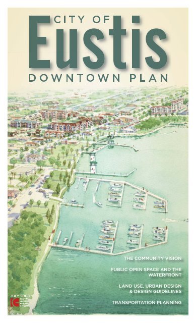
AERIAL PERSPECTIVE SHOWING NEW MARINA, DOWNTOWN REDEVELOPMENT,<br />
AND AN ENHANCED WATERFRONT
Study Area<br />
• North Boundary<br />
SR19 & CR 452<br />
• South Boundary<br />
Lakeview Ave<br />
• West Boundary<br />
Lake <strong>Eustis</strong><br />
• East Boundary<br />
Mary Street<br />
THE STUDY AREA<br />
STEERING COMMITTEE WALKING AUDIT<br />
Using the common visions from these efforts, the<br />
design team conducted a walking audit with the<br />
<strong>City</strong>-appointed Steering Committee. This walking<br />
audit yielded valuable on-site realizations about<br />
the needs and desires <strong>of</strong> the <strong>City</strong>.<br />
background and summary the planning process<br />
THE MASTER PLANNING PROCESS<br />
The design team reviewed the previous<br />
visioning efforts made by the <strong>City</strong> and<br />
various consultants including the Strategic<br />
<strong>Plan</strong> 2007-2012-2022, <strong>Eustis</strong> Community<br />
Visioning Meetings conducted from April<br />
to May <strong>of</strong> 2007, and Building Bridges for<br />
Economic Development – Lake County, FL.<br />
Various other key stakeholders, including all<br />
the Commissioners and other members <strong>of</strong> the<br />
community, were interviewed and their input<br />
was incorporated into the study.<br />
In addition to several stakeholders and Steering<br />
Committee meetings, three public meetings<br />
were held, at which input in various forms was<br />
accepted. Over the course <strong>of</strong> these meetings<br />
it is estimated that over 120 <strong>Eustis</strong> residents<br />
attended. The second public meeting included<br />
an interactive session where participants were<br />
asked to place ‘dots’ on themes that were most<br />
important to them.<br />
These themes were later ranked and organized<br />
into draft themes that formed the basis <strong>of</strong> the<br />
design principles and ultimately framed the<br />
master plan.<br />
PUBLIC MEETINGS AND COMMON VISIONS<br />
• Promote Mixed Uses In and Near the <strong>Downtown</strong><br />
• Encourage “Mom & Pop” Stores<br />
• Promote the Arts<br />
• Encourage Pedestrianism, Walkability, and Park<br />
Space<br />
• Take Advantage <strong>of</strong> Lake <strong>Eustis</strong><br />
• Protect the Existing Character<br />
• Increase Density in Appropriate Areas<br />
• Alternative Options for the “Corridors” (US 19 &<br />
SR 44)<br />
• Become Green and Sustainable<br />
CITY OF EUSTIS | DOWNTOWN PLAN 7
principles and objectives<br />
INTRODUCTION Based on an existing conditions analysis and the citizen-driven themes, the<br />
design team formed seven fundamental design principles to guide the <strong>Master</strong> <strong>Plan</strong> effort. These<br />
principles are as follows:<br />
Capitalize on Strategic<br />
<strong>Downtown</strong> Parcels<br />
<strong>Downtown</strong> <strong>Eustis</strong> has a few key parcels that,<br />
if redeveloped within the vision <strong>of</strong> the master<br />
plan, would quickly re-position the <strong>City</strong> center<br />
as a livable, walkable place.<br />
8 CITY OF EUSTIS | DOWNTOWN PLAN<br />
Leverage the Assets<br />
(Historic <strong>Downtown</strong> Lakefront)<br />
The regional uniqueness <strong>of</strong><br />
<strong>Eustis</strong> is derived from the<br />
historic downtown waterfront<br />
setting. This aspect can be<br />
leveraged to attract the kind <strong>of</strong><br />
development that is consistent<br />
with the existing pattern, while<br />
simultaneously balancing<br />
the future infrastructure and<br />
population needs.<br />
Connect to the Waterfront<br />
The waterfront is <strong>Eustis</strong>’ biggest asset and<br />
therefore should be the primary focus <strong>of</strong> the<br />
downtown master plan. Through streetscaping<br />
and other methods, the value and richness <strong>of</strong><br />
the waterfront should be extended easterly<br />
into the downtown core and residential<br />
neighborhoods.
The <strong>City</strong> Should be<br />
Walkable and Beautiful<br />
A common theme from the citizen input was the<br />
general improvement <strong>of</strong> the beauty and walkability<br />
<strong>of</strong> the <strong>City</strong>. This should be achieved through an<br />
overall focus on stronger and healthier pedestrian<br />
environments and the implementation <strong>of</strong> more<br />
extensive street tree canopy.<br />
Reconnect the<br />
Neighborhoods<br />
The in-town residential neighborhoods are the lifeblood<br />
<strong>of</strong> the <strong>Downtown</strong> core. These neighborhoods should<br />
be reconnected through continuous streets, adequate<br />
pedestrian facilities, and viewsheds to Lake <strong>Eustis</strong>.<br />
principles and objectives<br />
A balance must be struck between the pedestrian needs<br />
and general livability and the demands <strong>of</strong> the roadways<br />
to enhance the overall community vision.<br />
Balance the Pedestrian Needs<br />
and Transportation Needs<br />
In order to ensure the success <strong>of</strong> the citizen-based vision,<br />
the <strong>Downtown</strong> <strong>Eustis</strong> <strong>Master</strong> <strong>Plan</strong> should be reflected in<br />
a regulatory structure that is implementable within a<br />
market-based economic strategy.<br />
Create a Regulatory and<br />
Economic Structure that<br />
Supports and Markets the<br />
Vision<br />
CITY OF EUSTIS | DOWNTOWN PLAN 9
the master plan — “three phases”<br />
The <strong>Downtown</strong> <strong>Eustis</strong> <strong>Master</strong> <strong>Plan</strong> is broken into three phases to reflect an implementable strategic<br />
action plan.<br />
10 CITY OF EUSTIS | DOWNTOWN PLAN
the master plan — “three phases”<br />
The second phase builds upon the<br />
implementation <strong>of</strong> Phase I and focuses on<br />
a new marina development to capitalize on<br />
Lake <strong>Eustis</strong> as a major asset. The marina<br />
is broken into two phases for a total <strong>of</strong> 48<br />
new wet slips in <strong>Downtown</strong>. Phase II also<br />
considers the rebounding housing market<br />
and suggests a focus on developing infill<br />
residential <strong>of</strong> various types in and around the<br />
core downtown and in-town neighborhoods.<br />
The beautification and livability efforts in<br />
Phase I will make this in-town residential more<br />
attractive and succeed in the goal <strong>of</strong> bringing<br />
more residents into the <strong>Downtown</strong>.<br />
Phase I<br />
The first phase <strong>of</strong> the <strong>Master</strong> <strong>Plan</strong> involves<br />
items that can be controlled and modified by<br />
the <strong>City</strong>. This includes general beautification,<br />
pedestrian crossings and general walkability,<br />
new streetscapes and street tree plantings,<br />
required infrastructure, and a stormwater<br />
master plan. Phase I also includes a focus on<br />
updated <strong>Downtown</strong> signage and wayfinding,<br />
urban design standards, marketing<br />
and development efforts, and strategic<br />
partnering with regional entities to achieve<br />
broader based efforts.<br />
Phase II<br />
Phase III<br />
Phase III considers that the residential market<br />
has rebounded and that the <strong>City</strong> has positioned<br />
itself well through Phases I and II. Phase III<br />
examines three catalyst sites that <strong>of</strong>fer the most<br />
development potential for a higher density,<br />
mixed-use project. The sites were selected<br />
based on cost to redevelop, likelihood <strong>of</strong><br />
change, and overall redevelopment potential.<br />
CITY OF EUSTIS | DOWNTOWN PLAN 11
the master plan — phase one<br />
PROGRAM THE WATERFRONT<br />
North End Marina<br />
The north end <strong>of</strong> the contiguous waterfront would be<br />
anchored by the Marina which would serve more active<br />
boating uses on the Lake such as motor boats and jet skis.<br />
Focusing this use on the north side <strong>of</strong> the park separates<br />
it from the more passive uses to the south, but it still is<br />
within reasonable walking distance to the <strong>Downtown</strong>.<br />
Extend the Park to Bay Street<br />
The Lake Walk would remain in place and be enhanced by<br />
extending additional park areas all the way to Bay Street. Some<br />
quantity <strong>of</strong> <strong>of</strong>f-street parking would remain adjacent to the Crazy<br />
Gator’s restaurant, but other areas <strong>of</strong> parking would convert to<br />
green space. The <strong>Eustis</strong> Main Street building would also remain,<br />
but become a piece <strong>of</strong> park architecture or a future transit station.<br />
Enhance Ferran Park<br />
One <strong>of</strong> the most important comments from the public meetings was<br />
to maintain the Ferran Park viewsheds from the park out to the<br />
Lake. The <strong>Master</strong> <strong>Plan</strong> calls for making improvements to Ferran Park<br />
including more groundcover and colorful shrubs, as well as other<br />
site amenities like lighting, swings, and uniform site furnishings.<br />
Consider Expanding the Park through Sharp’s Park<br />
As Sharp’s Park redevelops, there is an opportunity to extend Ferran<br />
Park to Sunset Island Park.This will create a new place for<br />
other park amenities, like walking trails, large open<br />
spaces for gathering or watching fireworks, and<br />
even a small stage area for children to play.<br />
Passive Park<br />
Kayaks,<br />
Canoes<br />
12 CITY OF EUSTIS | DOWNTOWN PLAN<br />
Active Marina<br />
Extend the<br />
Park<br />
Ferran Park<br />
Viewsheds<br />
Expand Ferran Park<br />
Refocus Sunset Island Park for Passive Recreation<br />
The existing Sunset Island Park could be reprogrammed<br />
to accommodate more passive uses<br />
on the Lake such as kayaking and canoeing. Walking<br />
trails would connect the existing tennis courts and<br />
play areas with the rest <strong>of</strong> the waterfront amenities,<br />
creating a continuous circuit from Sunset Island Park<br />
to Ferran Park, to the Lake Walk, to the History Museum,<br />
to the Community Center, and finally to the new Marina.
the master plan — phase one<br />
WALKABILITY & BEAUTIFICATION<br />
BEAUTIFICATION<br />
The first phase <strong>of</strong> the <strong>Master</strong> <strong>Plan</strong> entails basic beautification efforts in and around the <strong>Downtown</strong><br />
Core. These efforts will greatly improve property values, but moreover will create a more pleasant<br />
and unique identity for the <strong>Downtown</strong> which will begin to set it apart from other cities in the<br />
region.<br />
PROGRAM THE WATERFRONT<br />
The Lakefront is one <strong>of</strong> the biggest assets<br />
in the <strong>City</strong>. However, currently it’s underprogrammed<br />
and therefore underutilized.<br />
<strong>Eustis</strong> needs a “Great Park” and the<br />
waterfront presents a unique opportunity.<br />
Great Parks are centers <strong>of</strong> community life<br />
composed <strong>of</strong> discrete outdoor rooms,<br />
shaded paths, and garden architecture.<br />
They are inclusive social hubs, relevant<br />
on “every” days and on “special” days,<br />
activated by people who are playing,<br />
watching, resting, eating, listening, and<br />
learning. They are understandable places<br />
<strong>of</strong> civic pride, beauty, and gentility.<br />
WALKABILITY<br />
In addition to adding beauty to<br />
the <strong>Downtown</strong> Core, the <strong>City</strong><br />
must become a more walkable<br />
place. Installing <strong>of</strong> street trees<br />
and changing the section <strong>of</strong> some<br />
roadways will slow drivers through<br />
the <strong>Downtown</strong> while continuing to<br />
efficiently accommodate vehicles.<br />
The following will further enhance<br />
the <strong>Downtown</strong> Core:<br />
• <strong>Plan</strong>ting Street Trees<br />
• Consistent Street Furniture on “A”<br />
Streets<br />
• Wider Sidewalks<br />
• Bike Lanes<br />
• On-Street Parking<br />
• <strong>Plan</strong>ting Native, Xeric, and Flowering<br />
<strong>Plan</strong>ts on “A” Streets<br />
• Improve or Upgrade Crosswalks<br />
• Upgrade or Repair Crosswalks Ramps<br />
• Canopy or Shade Structures Over<br />
Business Entrances<br />
EXISTING GROVE STREET - NOT WALKABLE<br />
PROPOSED GROVE STREET - VERY WALKABLE<br />
CITY OF EUSTIS | DOWNTOWN PLAN 13
the master plan — phase one<br />
STREETSCAPES<br />
PROPOSED BAY STREET<br />
PROPOSED GROVE STREET<br />
SLOW DOWN THE TRAFFIC<br />
Streetscape elements will help to slow traffic<br />
and create a more walkable <strong>Downtown</strong>. The<br />
<strong>City</strong> also could request that the posted speed<br />
limit <strong>of</strong> 35 MPH be lowered in the Core (Bates<br />
Avenue to Orange Avenue) to 25 MPH and 30<br />
MPH north and south <strong>of</strong> those boundaries.<br />
While this would increase the travel time<br />
through <strong>Downtown</strong> <strong>Eustis</strong> by approximately 30<br />
seconds, the walkability and pedestrian safety<br />
would significantly increase.<br />
14 CITY OF EUSTIS | DOWNTOWN PLAN<br />
BAY STREET AND GROVE STREET<br />
The existing Bay St. and Grove St. have very wide<br />
sections. The <strong>Master</strong> <strong>Plan</strong> proposes narrowing the<br />
lane to 11’-0” and increasing the on-street parking<br />
spaces to a width <strong>of</strong> 9’-0”. While this is wider than<br />
typical standards, it allows the bulb-out areas to<br />
extend further and thereby slow down traffic.<br />
The section would include new street trees in<br />
planters or grates in the <strong>Downtown</strong> Core and in<br />
tree lawns outside the <strong>Downtown</strong> Core. Period<br />
lighting in the <strong>Downtown</strong> Core can highlight the<br />
historic qualities <strong>of</strong> <strong>Eustis</strong>. This could be combined<br />
with appropriate signage and banners within the<br />
<strong>Downtown</strong> Core.<br />
The sidewalk areas would be 7’-0” in some areas<br />
and grow to 13’-6” in areas <strong>of</strong> frontage retail, where<br />
retailers could place tables and chairs or other<br />
amenities in front <strong>of</strong> their stores.
ROAD CONNECTIVITY<br />
Overall walkability in the <strong>Downtown</strong> can be<br />
increased by reconnecting certain streets that<br />
have been broken over time. In the <strong>Downtown</strong><br />
Core, three specific connections are identified:<br />
CONNECT BATES AVENUE<br />
(TO SR 44)<br />
CONNECT LAKESHORE<br />
TO ORANGE AVENUE<br />
CONNECT<br />
MCDONALD<br />
AVENUE<br />
the master plan — phase one<br />
CONNECTIVITY<br />
TRAFFIC CALMING TOOLKITS<br />
As more roads get connected into the<br />
<strong>Downtown</strong>, the adjacent neighborhoods<br />
need to be taken into account. There<br />
are many different ways to “calm” traffic,<br />
which means making cars and trucks drive<br />
slower while they are in places where they<br />
should be driving slower. A “chicane”, at<br />
top, and a “mini-circle”, at bottom, are a<br />
couple <strong>of</strong> the many resources available to<br />
calm traffic.<br />
PEDESTRIAN CROSSING<br />
The walking audit conducted early in the design process showed that many <strong>of</strong> the pedestrian<br />
crossings in the <strong>Downtown</strong> Core are in disrepair or do not meet current American with Disabilities<br />
Act (ADA) standards. Focusing on the core intersections including Magnolia Ave. and Bay St. will<br />
help increase walkability and encourage more people to experience more <strong>of</strong> the <strong>Downtown</strong>. Various<br />
methods available to improve these crossings include: bricked crossing points, raised intersections,<br />
colored concrete at the center <strong>of</strong> each intersection, and signage and wayfinding.<br />
CITY OF EUSTIS | DOWNTOWN PLAN 15
the master plan — phase one<br />
STREETSCAPES<br />
EXISTING MAGNOLIA & EUSTIS<br />
OPTION 1: ANGLED & PARALLEL<br />
OPTION 2: PARALLEL BOTH SIDES<br />
The second option would remove<br />
angled parking altogether and replace<br />
it with parallel parking on both sides<br />
<strong>of</strong> the street. This would allow for a<br />
two-way roadway while increasing<br />
the sidewalk widths from 7’-0” to<br />
13’-6”, which would provide ample<br />
room for tables and chairs, walkways,<br />
and other site furnishings.<br />
Both options assume a loss <strong>of</strong> 18%<br />
to 30% <strong>of</strong> overall on-street parking.<br />
However, this could be <strong>of</strong>fset by better<br />
utilization <strong>of</strong> the public parking garage<br />
and improved pedestrian crossings at<br />
Orange Avenue and <strong>Eustis</strong> Street.<br />
16 CITY OF EUSTIS | DOWNTOWN PLAN<br />
MAGNOLIA AVENUE AND EUSTIS STREET<br />
Magnolia Avenue and <strong>Eustis</strong> Street are the historic “Main<br />
Streets” for <strong>Downtown</strong> <strong>Eustis</strong> and contain many <strong>of</strong> its<br />
unique shops and restaurants. Currently, the one-way road<br />
configuration limits the activity and retail potential <strong>of</strong> this<br />
main street. The <strong>Master</strong> <strong>Plan</strong> <strong>of</strong>fers two alternatives that<br />
would need further study.<br />
The first option removes angled parking from one side<br />
<strong>of</strong> the block and replaces it with parallel parking and an<br />
additional travel lane. This would allow for Magnolia to be<br />
two-way and also still reserve some on-street parking. The<br />
<strong>Plan</strong> also calls for back-in angled parking to replace the<br />
current angled parking. Back-in angled parking is safer,<br />
not only for the driver, but also for pedestrians and cyclists<br />
using the road.<br />
The other benefit is that the sidewalk area would increase<br />
from 7’-0” to 9’-0” giving more space for shoppers and<br />
retailers.<br />
ORIGINAL SECTION OF MAGNOLIA AVENUE IN 1926.<br />
MAGNOLIA AVENUE - TWO-WAY TRAFFIC, WIDER<br />
SIDEWALKS, AND BACK-IN ANGLED PARKING
STORMWATER MASTER PLAN<br />
DIAGRAM<br />
INFRASTRUCTURE<br />
INFRASTRUCTURE<br />
As part <strong>of</strong> the <strong>Master</strong> <strong>Plan</strong>, infrastructure issues were raised and concerns about the impact <strong>of</strong><br />
future development were expressed. A more detailed analysis <strong>of</strong> the infrastructure conditions and<br />
recommendations can be found in Appendix C – GAI Technical Memorandum.<br />
Pond<br />
(12)<br />
<strong>Downtown</strong><br />
Blocks<br />
the master plan — phase one<br />
MASTER STORMWATER PLAN<br />
In order to make the <strong>Downtown</strong> Core more appealing<br />
to potential developers and to solve some existing<br />
infrastructure problems, such as Lake <strong>Eustis</strong> water quality<br />
and flooding at Bay Street and Orange Avenue, the design<br />
team considered a stormwater master plan. In this plan,<br />
stormwater from streets and blocks would be re-directed<br />
away from Lake <strong>Eustis</strong> and into a treatment pond north<br />
<strong>of</strong> <strong>Downtown</strong> and adjacent to Orchid Lake. Preliminary<br />
engineering drawings suggest this pond could have a total<br />
volume <strong>of</strong> 164,000 cubic feet.<br />
Because <strong>of</strong> this total volume, twelve <strong>Downtown</strong> blocks<br />
would not require on-site retention. Not only does this<br />
benefit the potential for redevelopment on those blocks, it<br />
also redirects the run<strong>of</strong>f water away from Lake <strong>Eustis</strong>. The<br />
run<strong>of</strong>f water in the pond would receive primary treatment<br />
through selected plants in the pond. Eventually, the water<br />
would return to Lake <strong>Eustis</strong>, but in a much cleaner state.<br />
TYPICAL CITY RETENTION POND<br />
STORMWATER PARK AS COMMUNITY RESOURCE<br />
The stormwater pond serves a great need in terms<br />
<strong>of</strong> infrastructure, but it also fills a community need:<br />
parks and open space. Many valuable park elements PROPOSED STORMWATER PARK RETROFIT<br />
such as walking and jogging trails, exercise stations,<br />
benches, tot lots, swings, and other active-use elements can be incorporated into the Stormwater<br />
Park. Not only can this be done at the proposed Stormwater Park, but the <strong>City</strong> can also retr<strong>of</strong>it<br />
existing stormwater ponds in the community to make them more park-like. In addition to improving<br />
the quality <strong>of</strong> life in the neighborhoods, property and social values will also increase.<br />
CITY OF EUSTIS | DOWNTOWN PLAN 17
the master plan — phase one<br />
URBAN DESIGN STANDARDS<br />
TYPICAL EXAMPLE (MIXED-USE BUILDING LOT) FROM THE<br />
PROPOSED LAND DEVELOPMENT REGULATIONS<br />
GREEN STREETS<br />
Many cities around the country are<br />
beginning to install Green Streets.<br />
These streets capture run-<strong>of</strong>f water<br />
from the street and return it to the<br />
soil as quickly as possible. Tree<br />
lawns serve as the initial capture<br />
area. These areas are planted with<br />
water-tolerant trees and shrubs<br />
that also pull pollutants from the<br />
water before it is absorbed into<br />
the soil. This relieves the burden <strong>of</strong><br />
trying to capture the run-<strong>of</strong>f from<br />
streets and potentially eases the<br />
requirements for the Stormwater<br />
Park. The <strong>City</strong> should implement<br />
“Green Streets” where possible for<br />
all new streetscapes.<br />
18 CITY OF EUSTIS | DOWNTOWN PLAN<br />
URBAN DESIGN STANDARDS<br />
AND COMPREHENSIVE PLAN<br />
MODIFICATIONS<br />
The current regulations and<br />
Comprehensive <strong>Master</strong> <strong>Plan</strong> are<br />
fairly suburban in nature and are not<br />
in line with the community vision<br />
expressed through the various<br />
stakeholder and public meetings.<br />
The current densities and intensities<br />
allowed, as well as the allowable floor<br />
area ratio, result in a development<br />
pattern that does not maximize<br />
the full efficiency <strong>of</strong> potential<br />
redevelopment blocks.<br />
Currently, the <strong>City</strong> is engaged in<br />
reformatting the Land Development<br />
Regulations that will focus on<br />
building form and massing as well<br />
as lot layouts and setbacks to<br />
achieve a building envelope, as<br />
opposed to specific floor area ratio<br />
requirements.<br />
These modifications will make<br />
the <strong>Downtown</strong> more livable and<br />
walkable, and will begin to match<br />
future development with the historic<br />
nature <strong>of</strong> <strong>Downtown</strong>, but as well as<br />
the desired vision <strong>of</strong> the citizens.
the master plan — phase one<br />
MARKETING THE DOWNTOWN<br />
The final piece <strong>of</strong> Phase I is to begin a new approach to marketing <strong>Eustis</strong> and specifically the<br />
<strong>Downtown</strong>. There are many marketing projects that are consistent with the need for beautification<br />
and greater walkability, but others have to do with strategic positioning.<br />
TYPICAL EXISTING<br />
DECORATIVE, FDOT, AND<br />
REGULATORY SIGNAGE IN<br />
EUSTIS<br />
The <strong>Master</strong> <strong>Plan</strong> suggests generating a consistent and<br />
well-designed signage and wayfinding master plan.<br />
The first piece <strong>of</strong> this plan is to create one cohesive<br />
identity or brand for the <strong>City</strong> and the <strong>Downtown</strong>.<br />
Once this is established, a palette <strong>of</strong> signage can<br />
be applied in strategic places to serve the needs<br />
<strong>of</strong> the drivers, pedestrians, locals, and visitors. In<br />
addition to vehicular and pedestrian signs, gateway<br />
signs should be installed at the major entrances to<br />
the <strong>City</strong>. These signs can be unique and potentially<br />
have an interchangeable portion to announce future<br />
events or important social and cultural happenings.<br />
WAYFINDING “PALETTE” OF SIGNAGE<br />
MARKETING THE DOWNTOWN<br />
SIGNAGE AND WAYFINDING<br />
The existing signage and wayfinding in the <strong>City</strong> is a potpourri<br />
<strong>of</strong> logos and different sign types that do not comply with<br />
ADA, are misplaced in some cases, and occasionally are<br />
inconsistent with the historic nature <strong>of</strong> the <strong>Downtown</strong>. Florida<br />
Department <strong>of</strong> Transportation (FDOT) regulatory signs are<br />
sometimes cluttered with non-regulatory signs, adding to the<br />
overall inconsistency. <strong>Eustis</strong> has standard issue regulatory<br />
signs; however, those signs can be unique while still meeting<br />
FDOT standards.<br />
EXISTING GATEWAY FROM US 441<br />
PROPOSED NEW GATEWAY<br />
EXAMPLE HISTORIC IDENTITY SIGN<br />
CITY OF EUSTIS | DOWNTOWN PLAN 19
the master plan — phase one<br />
MARKETING THE DOWNTOWN<br />
TAVARES<br />
20 CITY OF EUSTIS | DOWNTOWN PLAN<br />
FORM STRONG REGIONAL RELATIONSHIPS<br />
The <strong>City</strong> <strong>of</strong> <strong>Eustis</strong> would benefit greatly from<br />
forming stronger regional relationships with Lake<br />
County and the neighboring cities in the Golden<br />
Triangle: Tavares and Mt. Dora. A potential<br />
outcome would be a regional commuter rail.<br />
MOUNT DORA COMMUTER RAIL<br />
The railroad tracks north <strong>of</strong> <strong>Eustis</strong> have been<br />
removed, which makes <strong>Eustis</strong> the northern-most<br />
point on a potential commuter rail line. With the<br />
existing rail running through <strong>Downtown</strong>, adjacent<br />
to Ferran Park, and some existing structures like<br />
the <strong>Eustis</strong> Main Street Building, <strong>Eustis</strong> would be<br />
well-positioned to become the northern hub <strong>of</strong> the rail line. Regionally, riders from the north, west,<br />
and east would come to <strong>Eustis</strong> to travel to destinations south including Orlando and the theme<br />
parks and attractions.<br />
COORDINATED COMMUNITY EFFORTS<br />
The <strong>City</strong> <strong>of</strong> <strong>Eustis</strong> hosts many great social and cultural<br />
events. The <strong>City</strong> has a unique History Museum, a great<br />
theater troupe in the Bay Street Players, and a wonderful<br />
museum in the Lake <strong>Eustis</strong> Museum <strong>of</strong> Art. In addition, the<br />
<strong>City</strong> sponsors many large events including the Washington’s<br />
Day Parade and various events on the waterfront.<br />
The <strong>City</strong> should consider hiring an Event Coordinator<br />
whose primary responsibilities would be to orchestrate<br />
cultural events in the <strong>City</strong>, as well as coordinate community<br />
organizations in support <strong>of</strong> these events. Citizens will enjoy<br />
the events, businesses will thrive on the visiting crowds, and<br />
<strong>Eustis</strong> will build a reputation for being a livable, walkable,<br />
and fun place.<br />
THE ALICE MCCLELLAND MEMORIAL BANDSHELL AT<br />
FERRAN PARK<br />
SINCE 1902, EUSTIS HAS<br />
CELEBRATED THE WASHINGTON’S<br />
DAY PARADE<br />
THE LEMA SHOWCASES<br />
CONTEMPORARY ART<br />
THE CLIFFORD HOUSE<br />
HOLDS THE HISTORICAL<br />
SOCIETY’S COLLECTION<br />
THE BAY STREET PLAYERS<br />
ARE AN AWARD-WINNING<br />
THEATER TROUPE
DEVELOPER’S TOOLKIT<br />
Another tool used by many cities in marketing their<br />
downtowns is a “Developer’s Toolkit”. This toolkit<br />
contains information related to the vision <strong>of</strong> the <strong>City</strong> and<br />
highlights the key initiatives, demographic information,<br />
public investment programs, and specific contact<br />
people within the <strong>City</strong> to provide a transparent process<br />
for development. This would be a powerful document<br />
for people and businesses looking to invest in <strong>Eustis</strong>.<br />
With such a toolkit, the <strong>City</strong> could translate the vision<br />
<strong>of</strong> the <strong>Master</strong> <strong>Plan</strong> to focus those development efforts<br />
into something that the community can embrace. A<br />
Developer’s Toolkit could include:<br />
PLACE MAKING AND ADDRESS<br />
Many toolkits begin with information piece about the<br />
<strong>Downtown</strong> and the elements that make it unique and<br />
special. A vision statement and key initiatives are<br />
usually included to describe the future direction <strong>of</strong> the<br />
<strong>City</strong>.<br />
the master plan — phase one<br />
DEVELOPER’S TOOLKIT<br />
Developer’s Toolkit<br />
• Place Making and Address<br />
• Regulatory/Entitlements<br />
• Utilities and Infrastructure<br />
• Stormwater<br />
• Environmental Cleanup (Brownfield Sites)<br />
• Land Assembly and Catalyst Sites<br />
• Land Costs and Available Sites<br />
• Structured Parking<br />
REGULATORY/ENTITLEMENTS<br />
Describing existing and desired entitlements can help build surety between the development<br />
community and the <strong>City</strong>. Also, regulatory changes can be advertised to potential developers that<br />
may be more attracted to denser, in-town development options<br />
UTILITIES AND INFRASTRUCTURE<br />
Many cities describe their existing capacity or promote public work projects that could help spur<br />
development. Also, describing a transparent process or expectation <strong>of</strong> developers when it comes<br />
to contribution to infrastructure will also create more surety between the developer and the <strong>City</strong>.<br />
STORMWATER<br />
The <strong>City</strong> can market their efforts to create stormwater master plans that would help entice developers<br />
to build where there are limited needs for on-site retention.<br />
ENVIRONMENTAL CLEANUP (BROWNFIELD SITES)<br />
By identifying brownfield sites and beginning the process to clean them, the <strong>City</strong> can market this<br />
opportunity to developers who won’t need to pay for the cost to remediate the sites.<br />
LAND ASSEMBLY AND CATALYST SITES<br />
By listing specific sites or helping with land assembly, the <strong>City</strong> can make sites in the <strong>Downtown</strong><br />
more appealing to potential developers. This can also help the <strong>City</strong> maintain control over critical<br />
development sites.<br />
LAND COSTS AND AVAILABLE SITES<br />
Many municipalities advertise available sites within their downtown to help facilitate redevelopment.<br />
By listing the information available on the public tax roll, the <strong>City</strong> can help provide information for<br />
potential developers looking to invest in <strong>Downtown</strong> <strong>Eustis</strong>.<br />
STRUCTURED PARKING<br />
Many cities also participate in attracting redevelopment by <strong>of</strong>fering to partially pay for structured<br />
parking. As a quid pro quo, the <strong>City</strong> can reserve a certain amount <strong>of</strong> spaces for public use, while<br />
providing the developer with the needed spaces for higher density projects.<br />
CITY OF EUSTIS | DOWNTOWN PLAN 21
the master plan — phase two<br />
MARINA<br />
At the north end <strong>of</strong> the <strong>Downtown</strong> Core, a two-phase<br />
marina is proposed. In the first phase, the <strong>City</strong> would<br />
take advantage <strong>of</strong> the 20 to 25 slips already permitted by<br />
Army Corps <strong>of</strong> Engineers and build a modern marina that<br />
would capture <strong>Eustis</strong>’ portion <strong>of</strong> the growing wet boat<br />
slips for the Lake County Region. (See RERC’s Market<br />
Analysis – Appendix B)<br />
The northern portion <strong>of</strong> the <strong>Downtown</strong> Core is a good<br />
location for the marina due to its deeper water and the<br />
adjacent <strong>City</strong>-owned properties. The first phase would<br />
include 24 wet slips, a new boat ramp, a clubhouse with<br />
restrooms and a concessions building (for bait and tackle,<br />
as well as, some food and other sundries), and 24 car or<br />
trailer parking spaces.<br />
The second phase would include an additional 24 wet<br />
slips, dry stack storage for 45 boats, and the possibility<br />
for an expanded site that could include a restaurant<br />
and additional parking. Additional detail on the marina<br />
can be found in Halcrow Inc.’s Marina Technical Memo –<br />
Appendix D.<br />
22 CITY OF EUSTIS | DOWNTOWN PLAN<br />
<strong>Eustis</strong> Marina<br />
- 1st Phase – 24 slips<br />
- Boat Ramp<br />
- Concessions, Clubhouse<br />
- 24 Car/Trailer Parking Spaces<br />
- 2nd Phase – 24 Slips<br />
- Dry Stack Storage – 45 Boats<br />
- Possible Restaurant<br />
- Additional Parking<br />
2nd Phase<br />
1st Phase
As the residential market begins to balance out,<br />
infill residential will be an important focus for<br />
the <strong>Downtown</strong> Core. Bringing more residential<br />
into the <strong>Downtown</strong> is imperative for a healthy<br />
retail market and the fastest way the <strong>City</strong> can<br />
generate a larger residential population in<br />
the core. This residential can take the form<br />
<strong>of</strong>: attached condominiums, live/work units,<br />
artist-in-residence l<strong>of</strong>ts, two-to-three story<br />
townhomes, multi-level apartments, and<br />
small-scale, mixed-use residential. These<br />
kinds <strong>of</strong> denser residential can be built on<br />
smaller lots or combined lots. The Community<br />
Redevelopment Agency (CRA) can play an<br />
important role in helping to accumulate and<br />
assemble these properties while advertising<br />
the redevelopment potential.<br />
In addition to focusing on infill housing, the<br />
<strong>City</strong> can to incentivize residential to make it<br />
affordable. There are many different methods<br />
for encouraging affordability including the<br />
items listed in the adjacent table.<br />
MIXED-USE RESIDENTIAL<br />
LIVE/WORK HOUSING<br />
2-3 STORY CONDOMINIUMS<br />
the master plan — phase two<br />
INFILL RESIDENTIAL<br />
LOW-INCOME HOUSING TAX CREDIT (LIHTC)<br />
LIHTC, a federal program administered by the<br />
Florida Housing Finance Corporation, provides<br />
a developer with tax credits in exchange for<br />
the developer keeping a certain percentage<br />
<strong>of</strong> rental units affordable to specified income<br />
brackets.<br />
DOWN-PAYMENT ASSISTANCE<br />
The <strong>City</strong> <strong>of</strong> <strong>Eustis</strong> could establish a downpayment<br />
assistance program for low- or<br />
moderate-income homebuyers. Often, the<br />
grant is repaid when the grantee sells the home,<br />
so the funds can re-circulate and help another<br />
family.<br />
OTHER FEDERAL AND STATE PROGRAMS<br />
Numerous state and federal programs provide<br />
financing for affordable housing, including the<br />
federal HOME program and the state SHIP<br />
dollars.<br />
INCLUSIONARY ZONING<br />
The <strong>City</strong> could amend the Land Development<br />
Code to require that private developers<br />
incorporate a certain percentage <strong>of</strong> affordable<br />
units into their projects. While Inclusionary<br />
Zoning programs have a number <strong>of</strong> benefits,<br />
they can be difficult to implement in places<br />
without a strong real estate market.<br />
LINKAGE FEES<br />
Linkage fees can be assessed on commercial<br />
development, typically on a square foot<br />
basis, that can be used for affordable housing<br />
programs. Linkage fees work like impact fees:<br />
the <strong>City</strong> would have to prove a “rational nexus”<br />
between the fee and the need for affordable<br />
housing that is created by commercial<br />
development.<br />
REVISIONS TO BUILDING CODES<br />
Many building codes contain outdated or<br />
unnecessary requirements that add to the cost<br />
<strong>of</strong> new or rehabilitated housing. New materials<br />
and construction techniques are <strong>of</strong>ten safer<br />
and cheaper, but might not be permitted under<br />
existing codes.<br />
COMMUNITY LAND TRUSTS<br />
A relatively new idea in affordable housing,<br />
community land trusts (CLTs) are an efficient<br />
method <strong>of</strong> keeping for-sale housing affordable<br />
over a very long period <strong>of</strong> time. In a CLT, the<br />
land is owned by a non-pr<strong>of</strong>it organization<br />
or government entity. A homebuyer then<br />
purchases a home on that land, and signs a<br />
long-term, renewable lease for the land. The<br />
terms <strong>of</strong> the lease agreement restrict future<br />
sales prices, keeping the unit affordable in<br />
perpetuity. Although the resident does not own<br />
the land, they still have access to all the benefits<br />
<strong>of</strong> homeownership, including tax deductions.<br />
CITY OF EUSTIS | DOWNTOWN PLAN 23
the master plan — phase three<br />
CATALYST SITES<br />
FOUNDATION SITE<br />
The Lake <strong>Eustis</strong> Community Foundation owns three blocks in the <strong>Downtown</strong> Core that are primed<br />
for redevelopment. One block faces the Core retail streets -- Magnolia Avenue and <strong>Eustis</strong> Street<br />
-- and the other blocks face Bay Street and Grove Street, both <strong>of</strong> which are critical corridors<br />
in the redevelopment <strong>of</strong> the <strong>Downtown</strong> Core. The design team considered several options for<br />
redevelopment potential, including: what is currently allowed by the <strong>City</strong> <strong>of</strong> <strong>Eustis</strong>’ Code; a market<br />
reality-based scheme; and a high-end scheme showing a maximum development potential. Both the<br />
market reality-based scheme and the high-end scheme would be allowed by the Land Development<br />
Regulations being proposed for <strong>Eustis</strong>.<br />
HIGH-END REDEVELOPMENT<br />
Residential: 104 Dwelling Units •<br />
Retail/Office/Com: 83,100 sqft •<br />
Parking: 642 spaces (Structured Pkg) •<br />
Height: 4-5 stories •<br />
24 CITY OF EUSTIS | DOWNTOWN PLAN<br />
EXISTING SITE<br />
CONDITIONS<br />
• 6.3 Acres<br />
• 1,800 Linear Feet “A” Street<br />
Frontage<br />
• General Notes: Current<br />
Undeveloped<br />
EXISTING REDEVELOPMENT<br />
OPTION<br />
• Residential: 72 Dwelling Units<br />
• Retail/Office/Com: 21,450 sqft<br />
• Parking: 194 spaces<br />
• Height: 1-2 stories<br />
• 25% Open Space Requirement<br />
MARKET-BASED<br />
REDEVELOPMENT<br />
• Residential: 93 Dwelling Units<br />
• Retail/Office/Com: 50,200 sqft<br />
• Parking: 310 spaces<br />
(Structured Parking)<br />
• Height: 3-4 stories<br />
PROTOTYPICAL<br />
BUILDING<br />
EXAMPLES
SHOPPING CENTER<br />
On the north side <strong>of</strong> the <strong>Downtown</strong> Core, along Grove Street, an underdeveloped strip commercial<br />
shopping center represents one <strong>of</strong> the larger redevelopment opportunities in the <strong>Downtown</strong>. Due<br />
to the large amount <strong>of</strong> surface parking available, this site also <strong>of</strong>fers the opportunity for a mix <strong>of</strong><br />
uses, including residential and <strong>of</strong>fice space. To capitalize on the redevelopment potential <strong>of</strong> this<br />
area, the bounding streets can be turned into “A” streets by extending Bates Avenue from Grove<br />
Street to Center Street, as described in Phase One, and eventually to Prescott Street. In both the<br />
market-based scenario and the high-end scenario, a large footprint structure could be attractive<br />
to larger-format commercial or educational entities, such as an urban grocery store or a satellite<br />
campus <strong>of</strong> Lake-Sumter Community College.<br />
PROTOTYPICAL<br />
BUILDING<br />
EXAMPLES<br />
the master plan — phase three<br />
EXISTING SITE CONDITIONS<br />
7.2 Acres •<br />
1,140 Linear Feet “A” Street •<br />
Frontage •<br />
General Notes: Multiple •<br />
Ownerships •<br />
EXISTING REDEVELOPMENT<br />
OPTION<br />
Residential: 21 Dwelling Units •<br />
Retail/Office/Com: 35,600 sqft •<br />
Parking: 175 spaces •<br />
Height: 1-2 stories •<br />
25% Open Space Requirement •<br />
MARKET-BASED<br />
REDEVELOPMENT<br />
Residential: 30 Dwelling Units •<br />
Retail/Office/Com: 35,600 sqft •<br />
Parking: 188 spaces •<br />
Height: 2-3 stories •<br />
CATALYST SITES<br />
HIGH-END REDEVELOPMENT<br />
• Residential: 57 Dwelling Units<br />
• Retail/Office/Com: 111, 900 sqft<br />
• Parking: 660 spaces (Structured Parking)<br />
• Height: 3-4 stories<br />
CITY OF EUSTIS | DOWNTOWN PLAN 25
the master plan — phase three<br />
CATALYST SITES<br />
SHARP’S PARK<br />
Adjacent to Ferran Park on the south side <strong>of</strong> the <strong>Downtown</strong> Core is the Sharp’s Park Mobile Home<br />
Community. This use is not consistent with the community vision <strong>of</strong> <strong>Downtown</strong> and <strong>of</strong>fers a prime<br />
opportunity for redevelopment. The site is under one ownership and spans across Lakeshore Drive<br />
(County Road 452). As identified in Phase One, Lakeshore Drive is proposed to connect to Orange<br />
Avenue, which would <strong>of</strong>fer two unique opportunities. First, the land between Lakeshore Drive and<br />
Lake <strong>Eustis</strong> could be utilized as an extension <strong>of</strong> Ferran Park. This would provide an uninterrupted public<br />
lake frontage for approximately 3,600 feet. Secondly, the redevelopment could be a higher density<br />
residential, mixed-use product. This redevelopment could be taller and denser than development<br />
closer to the <strong>Downtown</strong> Core because it does not disrupt view corridors and can easily transition to<br />
the neighborhoods to the south.<br />
HIGH-END REDEVELOPMENT<br />
Residential: 295 Dwelling Units •<br />
Retail/Office/Com: 36,000 sqft •<br />
Hotel: 60 Rooms •<br />
Hotel Conference Space: 11,400 sqft •<br />
Parking: 840 spaces (Structured Pkg) •<br />
Height: 4-8 stories •<br />
26 CITY OF EUSTIS | DOWNTOWN PLAN<br />
EXISTING SITE CONDITIONS<br />
• 10.9 Acres<br />
• 1,200 Linear Feet “A” Street<br />
Frontage<br />
• General Notes: Current<br />
Undeveloped<br />
EXISTING REDEVELOPMENT<br />
OPTION<br />
• Residential: 51 Dwelling Units<br />
• Retail/Office/Com: 29,400 sqft<br />
• Parking: 220 spaces<br />
• Height: 1-2 stories<br />
• 25% Open Space Requirement<br />
MARKET-BASED<br />
REDEVELOPMENT<br />
• Residential: 132 Dwelling Units<br />
• Hotel: 54 Rooms<br />
• Parking: 320 spaces<br />
• Height: 3-4 stories<br />
PROTOTYPICAL<br />
BUILDING<br />
EXAMPLES
TWO-WAY CONVERSION OF BAY & GROVE<br />
The biggest hindrance to <strong>Downtown</strong> walkability is the one-way pair <strong>of</strong> Bay Street and Grove Street<br />
(State Road 19). This state road was converted from a two-way street to a one-way street system in<br />
the mid-1970’s because <strong>of</strong> peak traffic related to the former Waterman Medical Complex located in<br />
the <strong>Downtown</strong> Core. While the Medical Complex has since moved out <strong>of</strong> downtown, current traffic<br />
projections suggest the one-way pairs are still needed. Unfortunately, this does not consider the<br />
utilization <strong>of</strong> <strong>Eustis</strong> Street, which is currently underutilized because <strong>of</strong> the one-way portion through<br />
the <strong>Downtown</strong> Core.<br />
In Phase One, <strong>Eustis</strong> Street would be opened to two-way<br />
traffic and therefore become a viable alternative in dispersing<br />
traffic. In converting Bay Street, <strong>Eustis</strong> Street, and Grove<br />
Street to two-way traffic, the design team assumed that Bay<br />
Street would see a decrease from 50% dispersion to 40%;<br />
<strong>Eustis</strong> Street would see an increase from 0% to 10%; and Grove<br />
Street would see an increase from 50% to 60% dispersion.<br />
Today, travel time through <strong>Downtown</strong> <strong>Eustis</strong> takes about<br />
2.4 minutes. With this dispersion assumption and the twowaying<br />
<strong>of</strong> Bay Street and Grove Street, the travel time through<br />
<strong>Downtown</strong> would only increase by one minute to 3.5 minutes.<br />
The one minute difference is insignificant when compared to<br />
the increases in economic development <strong>of</strong> the blocks facing<br />
Bay and Grove, as well as the overall enhanced connectivity<br />
and walkability in the <strong>Downtown</strong> Core.<br />
Two alternatives were studied related to this dispersal. On<br />
the north end, the traffic could be dispersed through a timed<br />
signalization that would allow the outside lanes to continue<br />
through, while timing the interior lanes to allow traffic to<br />
choose between trips on Bay Street or Grove Street.<br />
the master plan — phase three<br />
TWO-WAY CONVERSION OF BAY & GROVE<br />
100%<br />
40%<br />
BAY ST<br />
100%<br />
10%<br />
EUSTIS ST<br />
60%<br />
GROVE ST<br />
On the south end, a roundabout is suggested at the intersection<br />
VEHICULAR DISPERSION<br />
<strong>of</strong> Grove Street, <strong>Eustis</strong> Street, and Ocklawaha Avenue. This<br />
would disperse traffic travelling northbound while southbound traffic would continue from Bay<br />
Street to SR 19. The projected traffic volumes suggest that travel time on Grove Street in the<br />
northbound direction would only increase by thirty seconds by 2025. The <strong>City</strong> blocks around<br />
these dispersal points will be reinvigorated by the two-way streets and provide redevelopment and<br />
numerous gateway opportunities for the <strong>City</strong>.<br />
NORTH DISPERSAL<br />
INTERSECTION<br />
SOUTH DISPERSAL<br />
ROUNDABOUT<br />
CITY OF EUSTIS | DOWNTOWN PLAN 27
conclusions - action items<br />
CONCLUSION<br />
The <strong>City</strong> <strong>of</strong> <strong>Eustis</strong> is in a unique time, place, and<br />
position. Although the real estate market is<br />
currently s<strong>of</strong>t, particularly with regard to residential<br />
development, the market will eventually rebound<br />
and the <strong>City</strong> should be prepared with revised plans<br />
and regulations to ensure the community vision will<br />
be achieved through redevelopment. Additionally,<br />
with rising gas prices, decreased vehicle miles<br />
traveled (VMT), and opportunities for mass transit,<br />
some <strong>of</strong> the traffic projections on <strong>Eustis</strong> streets<br />
could be overestimated, and overall travel time<br />
may not increase as much as anticipated. This<br />
means that opportunities to improve the quality<br />
<strong>of</strong> life and walkability will be available, which will<br />
improve economic development as well as access<br />
and mobility in and around the <strong>Downtown</strong> Core.<br />
The <strong>Eustis</strong> <strong>Master</strong> <strong>Plan</strong> establishes a specific vision<br />
for the future <strong>of</strong> <strong>Downtown</strong> <strong>Eustis</strong>. However,<br />
<strong>Master</strong> <strong>Plan</strong>s have a limited shelf life, particularly<br />
relative to recommended planning and policy<br />
actions. Without continued discourse and nearterm<br />
action, the energy and citizen consensus<br />
identified in the planning process will be lost and<br />
forgotten. By acting now, the <strong>City</strong> will be better<br />
equipped to respond to the marketplace.<br />
Commitment is vital to the success <strong>of</strong> <strong>Downtown</strong><br />
<strong>Eustis</strong>. The opportunity to succeed is there, but<br />
only if there are coordinated efforts between all<br />
parties and the continued dialogue with the public.<br />
<strong>Downtown</strong> <strong>Eustis</strong> has a tremendous potential<br />
as a regional center for urban living and a rich<br />
community built on the <strong>City</strong>’s unique arts, culture,<br />
and environmental resources. The following<br />
are a series <strong>of</strong> action items and implementation<br />
strategies based on the <strong>Downtown</strong> <strong>Eustis</strong> <strong>Master</strong><br />
<strong>Plan</strong> to guide the <strong>City</strong> towards achieving this<br />
community-driven process.<br />
NEIGHBORHOOD ACTIVITIES<br />
• Property Reinvestment<br />
• Single Family Homes<br />
• Infill Residential<br />
• Affordable/Attainable Housing<br />
DOWNTOWN ACTIVITIES<br />
• Surface Parked<br />
• Townhomes (12-24 du/ac)<br />
• <strong>City</strong> Homes (24-32 du/ac)<br />
• Mixed-Use Condo (Flats with Ground<br />
Floor Commercial)<br />
Future Development (2010-2020)<br />
Getting Ready (2008-2012, and beyond)<br />
ENHANCE THE DOWNTOWN ADDRESS<br />
• Lake <strong>Eustis</strong> Waterfront<br />
• Streetscapes<br />
• Wayfinding and Signage<br />
• Infrastructure Needs / <strong>Master</strong> Stormwater<br />
• Architectural Design Guidelines<br />
FOCUS ON THE NEIGHBORHOODS<br />
• Street Tree <strong>Plan</strong>ting<br />
• Lighting<br />
• Walkability Enhancements<br />
• Retr<strong>of</strong>it Stormwater Ponds as Parks<br />
• Property Enhancement Grants<br />
ESTABLISH THE PROPERTY FRAMEWORK<br />
• Design Standards<br />
• Flexible / Moderately Expanded Development<br />
Opportunities<br />
• Purchasing <strong>of</strong> Critical Properties<br />
• Assembly <strong>of</strong> Land<br />
ESTABLISH THE SOCIAL PATTERN - COMING<br />
TO DOWNTOWN<br />
• Coordinate <strong>Downtown</strong> Events<br />
• Expand <strong>Downtown</strong> Events<br />
• Capitalize on the Assets - Arts & Culture on<br />
the Waterfront<br />
MARKET DOWNTOWN TO THE DEVELOPMENT<br />
COMMUNITY<br />
• Work with Local Partners - Lake County,<br />
Golden Triangle<br />
• Create a Developer’s Toolkit<br />
• Be Connected to Things Bigger Than<br />
Yourself - Commuter Rail, etc.<br />
DEFEND YOUR POSITION<br />
• Flexible Advocacy <strong>of</strong> the Vision<br />
• Structured Parking<br />
• Mid-Rise Condominiums<br />
• 4-5 Stories<br />
• 50-70 du/ac<br />
• Ground Floor Office/Commercial<br />
• Potentially 3-4 Developments<br />
• High-Rise Condominiums/Apartments<br />
• 4-8 Stories<br />
• 60-70 du/ac<br />
• Ground Floor Office/Commercial<br />
• Potentially 1-2 Developments
CITY OF EUSTIS | DOWNTOWN PLAN