

MORAVIAN GEOGRAPHICAL REPORTS - Institute of Geonics ...
MORAVIAN GEOGRAPHICAL REPORTS - Institute of Geonics ...
MORAVIAN GEOGRAPHICAL REPORTS - Institute of Geonics ...

Create successful ePaper yourself
Turn your PDF publications into a flip-book with our unique Google optimized e-Paper software.
Vol. 18, 4/2010 MoraVian geographical reports<br />
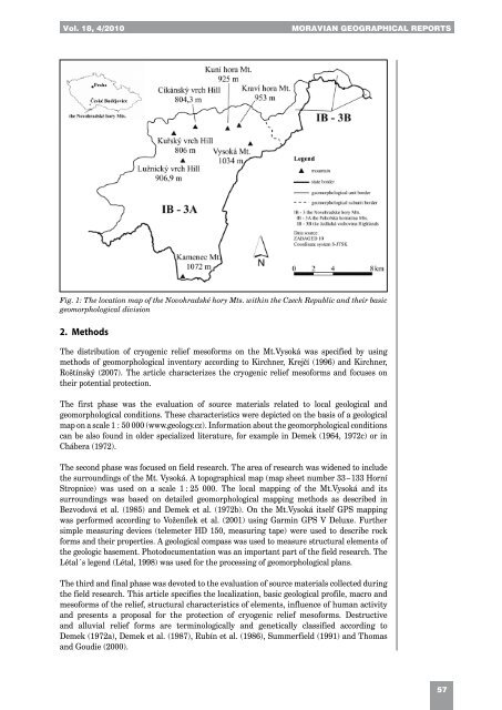
Fig. 1: The location map <strong>of</strong> the Novohradské hory Mts. within the Czech Republic and their basic<br />
geomorphological division<br />
2. Methods<br />
The distribution <strong>of</strong> cryogenic relief mes<strong>of</strong>orms on the Mt.Vysoká was specified by using<br />
methods <strong>of</strong> geomorphological inventory according to Kirchner, Krejčí (1996) and Kirchner,<br />
Roštínský (2007). The article characterizes the cryogenic relief mes<strong>of</strong>orms and focuses on<br />
their potential protection.<br />
The first phase was the evaluation <strong>of</strong> source materials related to local geological and<br />
geomorphological conditions. These characteristics were depicted on the basis <strong>of</strong> a geological<br />
map on a scale 1 : 50 000 (www.geology.cz). Information about the geomorphological conditions<br />
can be also found in older specialized literature, for example in Demek (1964, 1972c) or in<br />
Chábera (1972).<br />
The second phase was focused on field research. The area <strong>of</strong> research was widened to include<br />
the surroundings <strong>of</strong> the Mt. Vysoká. A topographical map (map sheet number 33 – 133 Horní<br />
Stropnice) was used on a scale 1 : 25 000. The local mapping <strong>of</strong> the Mt.Vysoká and its<br />
surroundings was based on detailed geomorphological mapping methods as described in<br />
Bezvodová et al. (1985) and Demek et al. (1972b). On the Mt.Vysoká itself GPS mapping<br />
was performed according to Voženílek et al. (2001) using Garmin GPS V Deluxe. Further<br />
simple measuring devices (telemeter HD 150, measuring tape) were used to describe rock<br />
forms and their properties. A geological compass was used to measure structural elements <strong>of</strong><br />
the geologic basement. Photodocumentation was an important part <strong>of</strong> the field research. The<br />
Létal´s legend (Létal, 1998) was used for the processing <strong>of</strong> geomorphological plans.<br />
The third and final phase was devoted to the evaluation <strong>of</strong> source materials collected during<br />
the field research. This article specifies the localization, basic geological pr<strong>of</strong>ile, macro and<br />
mes<strong>of</strong>orms <strong>of</strong> the relief, structural characteristics <strong>of</strong> elements, influence <strong>of</strong> human activity<br />
and presents a proposal for the protection <strong>of</strong> cryogenic relief mes<strong>of</strong>orms. Destructive<br />
and alluvial relief forms are terminologically and genetically classified according to<br />
Demek (1972a), Demek et al. (1987), Rubín et al. (1986), Summerfield (1991) and Thomas<br />
and Goudie (2000).<br />
57
