

MORAVIAN GEOGRAPHICAL REPORTS - Institute of Geonics ...
MORAVIAN GEOGRAPHICAL REPORTS - Institute of Geonics ...
MORAVIAN GEOGRAPHICAL REPORTS - Institute of Geonics ...

Create successful ePaper yourself
Turn your PDF publications into a flip-book with our unique Google optimized e-Paper software.
Vol. 18, 4/2010 MoraVian geographical reports<br />
images (since the 1970s). Although these information<br />
sources vary in scale, accuracy and information value,<br />
they represent the only base for long term land use<br />
development study.<br />
The main hypothesis for the central Spiš region land<br />
use study is: “Was the land use development <strong>of</strong> the<br />
study area different (due to its natural and social<br />
conditions) from the other neighbouring regions?”<br />
2. Study area<br />
The study area is situated in the Spiš region (NE<br />
Slovakia) and lays mainly in the Hornadska kotlina<br />
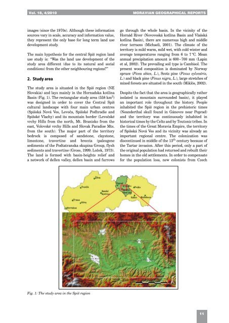
Basin (Fig. 1). The rectangular study area (558 km 2 )<br />
was designed in order to cover the Central Spiš<br />
cultural landscape with four main urban centres<br />
(Spišská Nová Ves, Levoča, Spišské Podhradie and<br />
Spišské Vlachy) and its mountain border (Levočské<br />
vrchy Hills from the north, Mt. Branisko from the<br />
east, Volovské vrchy Hills and Slovak Paradise Mts.<br />
from the south). The major part <strong>of</strong> the territory<br />
bedrock is composed <strong>of</strong> sandstone, claystone,<br />
limestone, travertine and breccia (paleogene<br />
sediments <strong>of</strong> the Podtatranska skupina Group, flysh<br />
sediments and travertine (Gross, 1999; Ložek, 1973).<br />
The land is formed with basin-heights relief and<br />
a network <strong>of</strong> dellen valley, dellen basin and furrows<br />
Fig. 1: The study area in the Spiš region<br />
go through the whole basin. In the vicinity <strong>of</strong> the<br />
Hornád River (Novoveská kotlina Basin and Vlašská<br />
kotlina Basin), there are numerous high and middle<br />
river terraces (Michaeli, 2001). The climate <strong>of</strong> the<br />
territory is mild warm, mild wet, with cold winter and<br />
average temperatures ranging from 6 to 7 °C. Mean<br />
annual precipitation amount is 600 – 700 mm (Lapin<br />
et al, 2002). The prevailing soil type is Cambisol. The<br />
present wood composition is dominated by Norway<br />
spruce (Picea abies, L.), Scots pine (Pinus sylvestris,<br />
L.) and black pine (Pinus nigra, L.), large stretches <strong>of</strong><br />
mixed forests are situated in the south (Miklós, 2002).<br />
Despite the fact that the area is geographically rather<br />
isolated (a mountain surrounded basin), it played<br />
an important role throughout the history. People<br />
inhabited the Spiš region in the prehistoric times<br />
(Neanderthal skull found in Gánovce near Poprad)<br />
and the territory was continuously inhabited in<br />
historical times by the Celts and by Teutonic tribes. In<br />
the times <strong>of</strong> the Great Moravia Empire, the territory<br />
<strong>of</strong> Spišská Nová Ves and its vicinity was already an<br />
important regional centre. The colonization was<br />
discontinued in middle <strong>of</strong> the 13 th century because <strong>of</strong><br />
the Tartar invasion. After this period, only a part <strong>of</strong><br />
the original population had returned and rebuilt their<br />
homes in the old settlements. In order to compensate<br />
for the population loss, new colonists from Czech<br />
11
