Florence/La Brea Station - ULI Los Angeles - Urban Land Institute
Florence/La Brea Station - ULI Los Angeles - Urban Land Institute
Florence/La Brea Station - ULI Los Angeles - Urban Land Institute

Create successful ePaper yourself
Turn your PDF publications into a flip-book with our unique Google optimized e-Paper software.
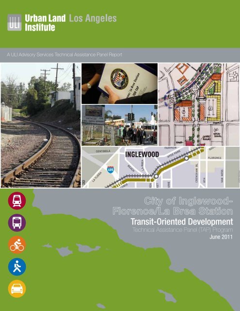
A <strong>ULI</strong> Advisory Services Technical Assistance Panel Report<br />
City of Inglewood-<br />
<strong>Florence</strong>/<strong>La</strong> <strong>Brea</strong> <strong>Station</strong><br />
Transit-Oriented Development<br />
Technical Assistance Panel (TAP) Program<br />
June 2011
<strong>ULI</strong> <strong>Los</strong> <strong>Angeles</strong> Mission Statement<br />
At the <strong>Urban</strong> <strong>La</strong>nd <strong>Institute</strong>, our mission is to provide leadership in the responsible use of land and in creating<br />
and sustaining thriving communities worldwide. <strong>ULI</strong> <strong>Los</strong> <strong>Angeles</strong>, a district council of the <strong>Urban</strong> <strong>La</strong>nd <strong>Institute</strong>,<br />
carries forth that mission as the preeminent regional real estate organization providing inclusive and trusted<br />
leadership influencing public policy and practice.<br />
About the <strong>ULI</strong> <strong>Los</strong> <strong>Angeles</strong> Technical Assistance Panels<br />
In keeping with the <strong>Urban</strong> <strong>La</strong>nd <strong>Institute</strong> mission, Technical Assistance Panels are convened to provide pro-bono<br />
planning and development assistance to public officials and local stakeholders of communities and nonprofit<br />
organizations who have requested assistance in addressing their land use challenges.<br />
A group of diverse professionals representing the full spectrum of land use and real estate disciplines typically<br />
spend one day visiting and analyzing the built environments, identifying specific planning and development<br />
issues, and formulating realistic and actionable recommendations to move initiatives forward in a fashion<br />
consistent with the applicant’s goals and objectives.<br />
Staff and Panel Members<br />
TAP Client<br />
City of Inglewood<br />
Panel Chair<br />
Philip Hart<br />
Owner, Hart Realty Advisors<br />
Panelists<br />
Michael Dieden<br />
Founder and Principal, Creative Housing Associates<br />
Said Gharbieh<br />
Principal, Arup<br />
Alan Pullman, AIA<br />
Senior Principal, Studio One Eleven<br />
Brad Rosenheim<br />
President and CEO, Rosenheim and Associates, Inc.<br />
C. Wil Soholt<br />
Senior Vice President, Kosmont Companies<br />
Don Spivack<br />
Consultant and former Deputy Chief of Operations,<br />
CRA <strong>Los</strong> <strong>Angeles</strong><br />
David Waite<br />
Partner, Jeffer Mangels Butler & Mitchell LLP<br />
TAP Committee Chair<br />
Jonathan Curtis<br />
Principal, Trevear Holdings LLC<br />
TOD Summit TAP Advisor<br />
Robert Gardner<br />
Managing Director, RCLCO<br />
<strong>ULI</strong> Project Staff<br />
Gail Goldberg<br />
Executive Director, <strong>ULI</strong> <strong>Los</strong> <strong>Angeles</strong><br />
Christine Aure<br />
Director, <strong>ULI</strong> <strong>Los</strong> <strong>Angeles</strong><br />
Ciara Contreras<br />
Project Manager, <strong>ULI</strong> <strong>Los</strong> <strong>Angeles</strong><br />
Stephen Sampson<br />
Graphic Designer<br />
Robert Andrews<br />
Analyst<br />
James Brasuell<br />
Analyst<br />
John Dlugolecki<br />
Photographer
Table of<br />
Contents<br />
Executive Summary � � � � � � � � � � � � � � � � � � � � � � � � � � � � � � 2<br />
Assignment & Process � � � � � � � � � � � � � � � � � � � � � � � � � � � � 4<br />
Background � � � � � � � � � � � � � � � � � � � � � � � � � � � � � � � � � � � 6<br />
Analysis � � � � � � � � � � � � � � � � � � � � � � � � � � � � � � � � � � � � � � 8<br />
Findings� � � � � � � � � � � � � � � � � � � � � � � � � � � � � � � � � � � � � � 9<br />
Recommendations � � � � � � � � � � � � � � � � � � � � � � � � � � � � � �11<br />
Financing Tools � � � � � � � � � � � � � � � � � � � � � � � � � � � � � � � �18<br />
Acknowledgements � � � � � � � � � � � � � � � � � � � � � � � � � � � � � �19<br />
Panel Members� � � � � � � � � � � � � � � � � � � � � � � � � � � � � � � � �20
Executive<br />
Summary<br />
2 City of Inglewood- <strong>Florence</strong>/<strong>La</strong> <strong>Brea</strong> <strong>Station</strong> Transit-Oriented Development Technical Assistance Panel Program<br />
The <strong>Florence</strong>/<strong>La</strong> <strong>Brea</strong> station will be one of two stops in the City of<br />
Inglewood along the planned Metro Crenshaw/LAX light rail transit<br />
(LRT) corridor. Scheduled to open between 2016 and 2018, the new<br />
Crenshaw/LAX LRT will connect the Expo Line LRT from the Expo/<br />
Crenshaw station to the Green Line LRT at the Aviation/LAX station.<br />
The 8.5-mile Crenshaw/LAX LRT will be funded by Measure R funds as<br />
part of an expansion of the countywide transit system that represents<br />
one of the largest public works investments in California.<br />
The planned <strong>Florence</strong>/<strong>La</strong> <strong>Brea</strong> station will be located adjacent to<br />
Downtown Inglewood and the Inglewood Civic Center, offering a<br />
rare opportunity to leverage public transit for the revitalization of<br />
the surrounding neighborhoods and the City as a whole. The City’s<br />
vision for the areas around the station is to stimulate the local<br />
economy, increase transit connections, and position the City as a<br />
regional destination. The key outcome will be to stimulate economic<br />
development in the Inglewood Downtown Commercial Corridor.<br />
The City of Inglewood engaged the <strong>Urban</strong> <strong>La</strong>nd <strong>Institute</strong> (<strong>ULI</strong>) <strong>Los</strong><br />
<strong>Angeles</strong> District Council in a Technical Assistance Panel (TAP) to<br />
study ways to maximize development and infrastructure opportunities<br />
at and around the planned <strong>Florence</strong>/<strong>La</strong> <strong>Brea</strong> station. The TAP convened<br />
on April 14, 2011, at Inglewood City Hall, bringing together experts in<br />
architecture and design, real estate development, economic analysis,<br />
and development financing to study the opportunities offered by the<br />
<strong>Florence</strong>/<strong>La</strong> <strong>Brea</strong> station.
The TAP evaluated the area within a half-mile radius of the planned station<br />
site, finding numerous opportunities to deliver viable transit-oriented<br />
development (TOD) to the nearby neighborhood while considering the<br />
difficulties that will challenge the full realization of the City’s goals for<br />
the <strong>Florence</strong>/<strong>La</strong> <strong>Brea</strong> station. The TAP study area lies within the City of<br />
Inglewood’s In-Town Redevelopment Area and benefits from flexible zoning<br />
and General Plan requirements that can allow the kinds of mixed-use and<br />
TOD development the City desires for the area.<br />
The TAP believes that in the near future, the <strong>Florence</strong>/<strong>La</strong> <strong>Brea</strong> station will<br />
welcome visitors to a revitalized and fully integrated Downtown Inglewood,<br />
anchored by a dynamic Market Street. The new Downtown will flourish with<br />
activity, spurred by adaptive reuse and new mixed-use development. A treelined<br />
median and wide sidewalks on <strong>Florence</strong> Avenue will provide traffic<br />
calming measures for pedestrian safety, announcing to transit riders and<br />
motorists that they have arrived in an significant place.<br />
The TAP also acknowledges the challenges to the realization of those goals,<br />
including the physical constraints of the station site (e.g., grade separation<br />
and a lack of the necessary barriers and buffers from existing businesses,<br />
including long-established industrial land uses located north of the station<br />
site). There also remains a perception that the station area and Downtown<br />
suffer from a lack public safety and hip cultural appeal. Moreover, the<br />
revitalization of the Downtown Inglewood will face competition from other<br />
development sites, including Hollywood Park Tomorrow, the Forum, and<br />
Century Boulevard.<br />
3
The new Crenshaw/LAX LRT will connect the Expo Line LRT from the Expo/Crenshaw station to the Green Line LRT at the Aviation/LAX station.<br />
Assignment & Process<br />
Key Issues<br />
The City of Inglewood engaged the <strong>Urban</strong> <strong>La</strong>nd<br />
<strong>Institute</strong> <strong>Los</strong> <strong>Angeles</strong> District Council to conduct a<br />
Technical Assistance Panel study for the purpose of<br />
developing a station area plan that defines a vision for<br />
the development of the <strong>Florence</strong>/<strong>La</strong> <strong>Brea</strong> station and<br />
leverages opportunities for public/private partnerships.<br />
The City of Inglewood identified the following major<br />
issues/questions for the TAP to address:<br />
1. Through a stakeholder interview process, assess<br />
local input from City staff, members of City<br />
Council, property owners, and community<br />
members about their visions and aspirations for<br />
the TOD station area.<br />
2. Provide objective, third-party feedback about the<br />
visions of stakeholders and present input regarding<br />
the opportunities for the <strong>Florence</strong>/<strong>La</strong> <strong>Brea</strong> station.<br />
What community benefits should be considered to<br />
achieve the goals of stakeholders and incentivize<br />
development (e.g., shared parking, joint use<br />
opportunities with private and non-private partners,<br />
cultural benefits, and physical improvements)?<br />
4 City of Inglewood- <strong>Florence</strong>/<strong>La</strong> <strong>Brea</strong> <strong>Station</strong> Transit-Oriented Development Technical Assistance Panel Program<br />
Panelists begin the day with a guided site tour to understand the study area.<br />
3. Considering the land that the City currently owns,<br />
assess catalytic sites and/or projects that can spur<br />
development in the near term. Characterize real<br />
estate development potential on these sites and<br />
describe the economic feasibility of development.<br />
4. Considering the above, what are some of the<br />
planning tools that can be used to implement the<br />
station area plan and achieve these goals?
Technical Assistance Panel (TAP)<br />
Process<br />
<strong>ULI</strong> panel members met with representatives<br />
from the City of Inglewood to determine the<br />
scope of the panel assignment. <strong>ULI</strong> selected<br />
panel members with practiced and professional<br />
skills that address the stated objectives for<br />
the TAP as provided by the City of Inglewood.<br />
Prior to the day-long program, panel members<br />
reviewed background materials prepared by the<br />
City of Inglewood.<br />
The TAP process is a day-long event. In the<br />
morning panel members tour the study area<br />
with representatives and later meet with key<br />
stakeholders, work through an intensive analysis<br />
on the specified issues and then present their<br />
findings to the general public and program<br />
sponsors.<br />
Planning Director Linda Tatum, City of Inglewood discusses<br />
study area development issues with panelist Don Spivack..<br />
The <strong>ULI</strong> TAP team explores the study area.<br />
The panel interviews City Councilmember Ralph Franklin to better understand the underlying physical, social and<br />
political issues.<br />
TAP Panel of Experts<br />
<strong>ULI</strong> convened a panel of professionals representing a variety of disciplines connected<br />
to land use and real estate development, such as architecture and design, real estate<br />
development, economic analysis, and development financing. The <strong>ULI</strong> selected panel<br />
members with the intent to convene a robust array of professional expertise relevant<br />
to the City’s objectives for the study. <strong>ULI</strong> also selected panel members with a working<br />
knowledge of the neighborhood, built environment, and real estate markets of the study<br />
area. All panel members volunteered to participate in the panel process and did not<br />
receive compensation for their work.<br />
5
The proposed station would be located in the Burlington Northern Santa Fe (BNSF) railroad right of way.<br />
Background<br />
About the Site<br />
Often referred to as the “Jewel of the South Bay”, the City of Inglewood nestles between<br />
the City of <strong>Los</strong> <strong>Angeles</strong>, LAX, and the other South Bay cities. The Crenshaw/LAX LRT,<br />
which will pass through Inglewood, represents a $1.7 billion transit investment for<br />
the region. The proposed light rail line will span 8.5 miles, connecting the Expo LRT<br />
to LAX, stopping at the <strong>Florence</strong>/<strong>La</strong> <strong>Brea</strong> station along the way. Scheduled to open<br />
between 2016 and 2018, the LAX/Crenshaw transit corridor, including the <strong>Florence</strong>/<br />
<strong>La</strong> <strong>Brea</strong> station, will present unprecedented opportunities to stimulate the economy of<br />
Inglewood.<br />
City of Inglewood<br />
<strong>Florence</strong>/<strong>La</strong> <strong>Brea</strong><br />
<strong>Station</strong><br />
Regional location of the <strong>Florence</strong> / <strong>La</strong> <strong>Brea</strong> <strong>Station</strong> study area.<br />
6 City of Inglewood- <strong>Florence</strong>/<strong>La</strong> <strong>Brea</strong> <strong>Station</strong> Transit-Oriented Development Technical Assistance Panel Program<br />
The intersection of <strong>Florence</strong> and <strong>La</strong> <strong>Brea</strong> is a key node in the study area.<br />
The land uses within the study area are a mix of various types of<br />
commercial uses.<br />
The <strong>Florence</strong>/<strong>La</strong> <strong>Brea</strong> station will extend for 300 feet<br />
between Locust and Market streets. There is a significant<br />
elevation change along the length of the proposed<br />
station site and between the station and surrounding<br />
neighborhoods. Several employers surround the<br />
proposed site of the station, including a Walgreens<br />
on the Northeast corner of the intersection and Don<br />
Lee Farms, which lies further east on the north side<br />
of <strong>Florence</strong> Avenue, abutting the proposed site of the<br />
<strong>Florence</strong>/<strong>La</strong> <strong>Brea</strong> LRT station. The proposed station<br />
would be located in the Burlington Northern Santa Fe<br />
(BNSF) railroad right of way that runs along the north<br />
side of <strong>Florence</strong> Avenue.<br />
The proposed site of the <strong>Florence</strong>/<strong>La</strong> <strong>Brea</strong> station<br />
lies within the boundaries of Inglewood’s In-Town<br />
Redevelopment Project Area. The redevelopment area<br />
includes the City’s Downtown and Civic Center—both<br />
of which offer significant opportunities for transitoriented<br />
development (TOD). Downtown Inglewood<br />
includes several hubs for existing and potential<br />
mixed-use development, including the Market Street<br />
Commercial Corridor and a parcel owned by the<br />
Inglewood Redevelopment Agency, known as the D3 site,<br />
directly across the street from the proposed <strong>Florence</strong>/<br />
<strong>La</strong> <strong>Brea</strong> station. A substantial multi-family residential<br />
neighborhood lies to the north of the station area, and<br />
single-family residential uses lie to the east of the area.<br />
A small collection of artist workspaces also lie to the<br />
north of the station area, adjacent to Don Lee Farms, but<br />
underutilized, vacant, or auto-dominated lots surround<br />
the station area.
Hollywood Park Tomorrow, the future site of a large<br />
mixed-use development called Hollywood Park<br />
Tomorrow, and the Forum are situated in the City<br />
of Inglewood near the <strong>Florence</strong>/<strong>La</strong> <strong>Brea</strong> station. The<br />
leadership of Inglewood expects Hollywood Park<br />
Tomorrow to be a catalytic development, eventually<br />
benefitting Downtown by attracting more visitors and<br />
residents to the City for the shopping and housing.<br />
The Forum has potential to become a large-scale<br />
entertainment and cultural amenity, capable of regularly<br />
drawing tens of thousands of visitors to the City. The<br />
<strong>Florence</strong>/<strong>La</strong> <strong>Brea</strong> <strong>Station</strong> could potentially capture<br />
transit users visiting the two nearby sites. However, the<br />
prominence of the nearby Century Boulevard corridor,<br />
which connects to LAX, has impacted the ability of<br />
the downtown neighborhood to attract large-scale and<br />
high-end commercial opportunities.<br />
To leverage the new LRT transit station to stimulate<br />
the local economy, increase transit connections, and<br />
position the City as a regional destination, the City of<br />
Inglewood has established the following vision for TOD<br />
plans for the <strong>Florence</strong>/<strong>La</strong> <strong>Brea</strong> station:<br />
• Establish a clean, safe, and pedestrian-oriented<br />
community, where residents shop and enjoy<br />
public and community events and services.<br />
• Guide all development, including land use,<br />
location, height and density, traffic circulation,<br />
pedestrian mobility, and transit connectivity to<br />
ensure synchronicity of uses for the economic<br />
and social well-being of area residents.<br />
• Create a transit-friendly area utilizing pedestrianoriented<br />
design guidelines that establish building<br />
façade treatments, landscape standards, criteria<br />
for shade-producing building overhangs and<br />
awnings, lighting for security, streets, alleys,<br />
sidewalks, and other pedestrian areas that adjoin<br />
new development.<br />
• Promote increased flexibility in the regulation of<br />
the height and bulk of buildings, as well as the<br />
design of sites and public streets, to ensure a<br />
well-planned combination of office, commercial,<br />
and residential uses that integrate with open<br />
space.<br />
• Encourage the creation of a lively civic<br />
atmosphere by facilitating collaborative public<br />
and private enterprises that promote cultural and<br />
entertainment districts that incorporate live-work<br />
habitats.<br />
Demographics<br />
According to statistics from the 2005-2009 U.S. Census Bureau American Community<br />
Survey, 112,279 people live in Inglewood, with an average household size of 2.97. The<br />
median age of the population is 31.5, with 68,575 residents (62 percent) over the age<br />
of 25 and 10,360 (9.2 percent) residents over the age of 65. Of residents over 25, 71.2<br />
percent have a high school degree or higher and 17.0 percent have a bachelor’s degree<br />
or higher.<br />
Approximately 55,112 (66.1 percent) of the City’s residents over the age of 16 are<br />
members of the labor force. Residents commute an average of 29 minutes. The median<br />
household income for the City is $42,235 per year, with a median family income of<br />
$44,188 per year. The per capita income is $18,996 per year—significantly less than<br />
the national per capita income of $27,041 per year.<br />
Inglewood deviates significantly from national averages with regard to several<br />
characteristics of the housing market. A total of 39,377 total housing units occupy<br />
the City, with a 94.4 percent total occupancy rate. The median value of a home in<br />
Inglewood is $434,400 (the national mean home value is $185,400). Inverting national<br />
averages, 36 percent of the City’s housing units are owner-occupied and 63.7 percent<br />
are renter-occupied (national figures are 66.9 percent and 33.1 percent, respectively).<br />
The demographics of the City of Inglewood show a culturally and racially diverse<br />
community. The majority of the City’s population is Hispanic or <strong>La</strong>tino, with 56,584<br />
(50.4 percent) residents. Approximately 48,853 (43.5 percent) residents are Black or<br />
African American, 22,050 (19.6 percent) are White, and 1,479 (1.3 percent) are Asian.<br />
Almost half—50,991 (49.9 percent)—of the City’s residents speak a language besides<br />
English at home, and 31,650 (28.2 percent) residents were born in a foreign country.<br />
<strong>La</strong> <strong>Brea</strong> Avenue is a transportation corridor well served by transit.<br />
7
The station site is located immediately across the street from a major redevelopment site that is ideally suited for<br />
mixed-use development.<br />
Analysis<br />
Strengths<br />
The proposed site of the <strong>Florence</strong>/<strong>La</strong> <strong>Brea</strong> station enjoys a strategic and catalytic<br />
location for transit-oriented development in the Market Street Commercial Corridor,<br />
which is within walking distance to the Inglewood Civic Center. The station site is<br />
located immediately across the street from a major redevelopment site that is ideally<br />
suited for mixed-use development. The station site is at a slightly higher elevation<br />
than Downtown and the Civic Center. Exiting the station and looking south over<br />
Downtown and the Civic Center provides visual appeal to the station location and the<br />
neighborhood. The elevation of the proposed station can create a sense of prominence<br />
and identity for both ingress and egress. The site will also serve existing residential<br />
communities located to the north of the station site. The site benefits from a natural<br />
pedestrian linkage to Market Street. North/south vehicular traffic will continue to travel<br />
along <strong>La</strong> <strong>Brea</strong> Avenue.<br />
Existing businesses and tenants (located in visually-appealing historic buildings)<br />
will activate pedestrian linkages to the station site. These businesses and amenities<br />
can anchor upgrades to the Downtown retail tenant base. Portions of the Downtown<br />
streetscape are visually appealing, with a variety of streetscapes and facades. An<br />
emerging artist community will catalyze incremental, creative, and adaptive uses for<br />
new retail opportunities. The artist community can enliven the Downtown district<br />
after business hours and create a greater sense of safety. There are several vacant<br />
City properties that can serve as opportunity sites for mixed use and residential<br />
development in Downtown. There are several opportunity sites to develop parking<br />
facilities to serve the station site and Downtown businesses. There is a strong<br />
commitment by the City’s new leadership to public safety and redevelopment. The<br />
City’s new Mayor stated that “Inglewood can become the next Culver City.” The station<br />
site can play a catalytic role in realizing that vision.<br />
8 City of Inglewood- <strong>Florence</strong>/<strong>La</strong> <strong>Brea</strong> <strong>Station</strong> Transit-Oriented Development Technical Assistance Panel Program<br />
Weaknesses<br />
Downtown Inglewood suffers from a substantial number<br />
of commercial vacancies along Market Street, and during<br />
the interview process, the panel noticed that transit users<br />
and other stakeholders perceive the area as unsafe. The<br />
City and has not been able to rebrand the community as<br />
a desirable place to live, work, and play following a prior<br />
generation of robust post-war economic development.<br />
Attention must be paid to make Downtown Inglewood<br />
a desirable destination for young people, including<br />
students in the area. There is a significant student<br />
population in the Downtown area with no reasonable<br />
or interesting destinations for social and educational<br />
interaction after school.<br />
The station site has physical limitations because of<br />
its grade separation and proximity to established<br />
businesses. The vehicle traffic on <strong>Florence</strong> and <strong>La</strong> <strong>Brea</strong><br />
deters pedestrian uses. The station site will require<br />
aesthetic improvements to make it inviting, user friendly,<br />
and safe. City budgets and resources are strained, and<br />
there is a chance that the Inglewood Redevelopment<br />
Agency could be abolished by Governor Jerry Brown’s<br />
proposal to eliminate Redevelopment Agencies in the<br />
State of California.<br />
Opportunities<br />
The location of the proposed station creates unique<br />
opportunities. It can use existing parking structures to<br />
serve riders and create strategic locations for additional<br />
structures that will draw pedestrians through Downtown<br />
to shop and dine while coming to and from the station<br />
site. The Metro parking lot on <strong>Florence</strong> can be used as a<br />
bus interchange to encourage ridership and public transit<br />
instead of automobile trips. Riders will walk through<br />
Downtown and patronize businesses while accessing the<br />
bus interchange and station site. Mixed use development<br />
The vehicle traffic on <strong>Florence</strong> and <strong>La</strong> <strong>Brea</strong> deters pedestrian uses.
should incorporate additional parking resources with<br />
residential and retail development. Multiple parking<br />
structures located throughout Downtown will create<br />
additional pedestrian linkages and activate Market<br />
Street and Downtown.<br />
The City should consider addition tools to encourage<br />
adaptive reuses of existing structures. The City should<br />
adopt a façade improvement program that encourages<br />
businesses to make improvements to commercial<br />
facades while capitalizing on the City’s cultural<br />
resources.<br />
The agency-owned D3 site presents a unique and<br />
catalytic site for redevelopment that will be the single<br />
most important factor in linking the station site to<br />
downtown and the Civic Center. The D3 site should<br />
include mixed-use development, including retail,<br />
office, residential development, and parking. The D3<br />
site should also include open space and plaza space<br />
for pedestrian and civic engagement, accommodating<br />
young and old, and create a venue for music, dance,<br />
and the arts. Needed traffic-calming improvements<br />
along <strong>Florence</strong> should create a sense of arrival to the<br />
City’s Downtown and encourage pedestrian linkages to<br />
the Civic Center.<br />
Threats<br />
The physical constraints of the station site include<br />
grade separation and a lack of necessary barriers<br />
and buffers from existing businesses, including long<br />
established adjacent industrial land uses located north<br />
of the station site. There remains a perception of a<br />
lack of public safety in the station area and Downtown.<br />
The revitalization of the Downtown Inglewood will face<br />
competition from other development sites, including<br />
Hollywood Park Tomorrow, the Forum, and Century<br />
Boulevard. However, the station site could create a<br />
competitive advantage to competing sites. For example,<br />
transit linkages from the station site to the Forum and<br />
Hollywood Park Tomorrow could enhance ridership and<br />
serve as an additional catalyst for Downtown retail and<br />
dining.<br />
Metro should consider relaxing parking requirements to<br />
encourage bus ridership and interchange opportunities.<br />
Findings<br />
A Metro Blue Line train departs from the Compton <strong>Station</strong>.<br />
Market Overview and Potential<br />
Driven by demand for contemporary residential and office space proximate to local<br />
amenities and activity centers, the commercial and residential markets near the<br />
planned station can potentially support adaptive reuse and new quality construction.<br />
Demand drivers for residential uses include the proximity to the future light rail<br />
station, the library, Market Street, local schools, and easy transit access to other<br />
amenities within the greater community. Drivers for commercial uses include the<br />
proximity to the future station, the courthouse, civic center, hospital, and nearby senior<br />
residential communities. While these drivers are appealing for development, demand<br />
for residential and commercial uses might also be tempered by existing supply in the<br />
market and overall market fundamentals.<br />
Since the peak in the housing market in 2006-07 and the recession in 2008-09, the<br />
commercial and residential markets have been impaired. The impairment of these<br />
markets has prohibited the creation of new product. Over time, however, market<br />
fundamentals are anticipated to improve, ultimately supporting rehabilitation and/<br />
or reuse of existing product as well as development of new product. Overall, rents<br />
and prices indicate the feasibility of smaller, contemporary units in an amenityrich<br />
environment. As fundamentals improve with time, price points might increase,<br />
supporting larger unit sizes and a better foundation for owner-occupied product types.<br />
Considering the financial barriers to desired developments, a variety of concessions<br />
or subsidies may facilitate the creation of desired product. To the extent that income<br />
restricted/affordable units are provided, subsidies will likely be necessary and<br />
warranted. Additionally, leniency on parking requirements and/or the provision of<br />
centralized public parking facilitates might help underwrite financially infeasible<br />
developments. Specific to the residential market, the fundamentals that drive for-sale<br />
versus for-rent product vary slightly, creating periods where one product type is more<br />
financially feasible than the other. If one product type is desired over another and the<br />
current market cycle does not support the desired product, development might need to<br />
be delayed to a more opportune time, or a subsidy or other assistance can be provided<br />
to accelerate development.<br />
9
The development of the area around the station may<br />
present a paradox of which comes first: the demand<br />
for the product or the supply of a critical mass of<br />
product and amenities. Thus, the demand to fully<br />
support desired development might only arrive<br />
following the development of a critical mass of new<br />
product and amenities. As such, financial subsidies or<br />
other incentives may be initially required to facilitate<br />
the development of critical mass and a hub in the<br />
community. Creative incentives may reduce developer<br />
risk associated with establishing a cornerstone<br />
development rather than just providing financial<br />
subsidies to compensate for elevated risk. Finally, as<br />
market fundamentals improve and, ultimately, vary with<br />
time, certain product types and development profiles<br />
will become more or less financially viable. As such, it<br />
will be important for the City to clearly establish a vision<br />
for the area, communicate that vision to the public, and<br />
prepare to capitalize on opportunities as they bloom.<br />
Issues to be Addressed<br />
It is important that the City of Inglewood recognize<br />
and accept the potential impacts associated with the<br />
gentrification of the Market Street Corridor. With<br />
gentrification comes a desirability of place and space,<br />
which leads landlords to seek increased rents that are<br />
out of the range of existing tenants. Existing tenants<br />
might have endeared themselves to the community over<br />
their many years of business, which can lead to conflict<br />
if they feel pushed out of business as a result of City<br />
efforts to enhance the community. It is important that<br />
City leaders honestly assess the potential consequences<br />
of redevelopment to ensure that they are willing to<br />
withstand the slings and arrows that might result from<br />
the successful implementation of gentrification.<br />
Financial subsidies or other incentives may be initially required to facilitate the development of critical mass and a hub in the community.<br />
10 City of Inglewood- <strong>Florence</strong>/<strong>La</strong> <strong>Brea</strong> <strong>Station</strong> Transit-Oriented Development Technical Assistance Panel Program<br />
Ideally, Market Street would become a thriving business corridor, anchored by larger<br />
market-rate and mixed-use housing developments at the north end of the street,<br />
with immediate proximity to the proposed <strong>Florence</strong>/<strong>La</strong> <strong>Brea</strong> station. The commercial<br />
corridor to the south of the mixed-use anchors would attract businesses that capitalize<br />
on the fixed residential population to the north, the Civic Center population to the west,<br />
and the broader community, which is currently underserved by retail uses. The retail<br />
and restaurant uses near the <strong>Florence</strong>/<strong>La</strong> <strong>Brea</strong> station will primarily be local; the growth<br />
of the nearby Century Boulevard corridor will attract the national chains. The City<br />
should encourage office uses to sustain Civic Center uses and also encourage medical<br />
offices to meet the needs of the local community. The City should also encourage new<br />
mixed-use projects throughout the Market Street Corridor at a scale complimentary to<br />
the immediate area.<br />
The aging CVS-anchored strip shopping center on the east side of Market Street should be joined with the<br />
adjacent agency-owned D3 site.
Philip Hart, Alan Pullman, Said Gharbieh & Don Spivack listen to a<br />
discussion of the study area findings.<br />
The TOD plan intends to create a thriving and integrated<br />
Downtown, Civic Center, and station area. Streetscape<br />
design that encourages pedestrian, bicycle, and local<br />
shuttle linkages will accomplish these goals for the<br />
area. The streetscape itself will suggest arrival at a<br />
special place, which will carry forth throughout the new<br />
Inglewood “Uptown”, signifying the unity in intent and<br />
purpose of the neighborhood. Inglewood “Uptown” will<br />
be further integrated into the City through communitybased<br />
events, such as farmers’ markets and other social<br />
and cultural events. The use of the term Inglewood<br />
“Uptown” should remind stakeholders that the vision for<br />
a new Downtown/Civic Center results from a thoughtful<br />
and purposeful marketing campaign.<br />
The TAP recommends a limited amount of retail shops and restaurants,<br />
along with professional service offices, which would serve the immediate<br />
neighborhood<br />
Recommendations<br />
Overall Vision<br />
In the year 2021, the <strong>Florence</strong>/<strong>La</strong> <strong>Brea</strong> <strong>Station</strong> of the Crenshaw/LAX LRT will welcome<br />
visitors to a revitalized and fully integrated Downtown Inglewood, anchored by a<br />
dynamic Market Street. The new Downtown will flourish with activity, spurred by<br />
adaptive reuse and new mixed-use development. A tree-lined median and wide<br />
sidewalks on <strong>Florence</strong> Avenue will provide traffic calming measures for pedestrian<br />
safety, announcing to transit riders and motorists that they have arrived in an<br />
significant place. Parking for transit riders and shoppers will be distributed into several<br />
“park once” structures, to be located at the D3 site, a repurposed CVS site, and the<br />
existing public garage on Market Street. A historically renovated Inglewood Theater, a<br />
spruced up bookstore, new cafés, an eclectic mix of ethnic restaurants, and art-related<br />
retail will provide an array of cultural, entertainment, and artistic programming. The<br />
new Downtown will connect to residential neighborhoods to the north of the station via<br />
an attractive pedestrian breezeway, linking <strong>La</strong> Colina and Beach Avenue. The cafés and<br />
restaurants along Market Street will capture the civic and courthouse lunch time and<br />
happy hour traffic. A weekly farmers’ market, children’s events, and holiday festivals<br />
will program civic spaces. Bicycle infrastructure and a new bike shop will cater to an<br />
active and healthy bicycle scene. A civic-minded celebrity will locate offices and a<br />
destination restaurant on Market Street. Downtown Inglewood will be on the “Southern<br />
California must-see map”.<br />
The TAP Panelists begin sketching out their vision and recommendations for Transit-Oriented Development<br />
around <strong>Florence</strong> and <strong>La</strong> <strong>Brea</strong>.<br />
11
<strong>Station</strong> Design Improvements<br />
The current station plans, which show a ramp along the south wall of the station<br />
trench leading to a pedestrian crossing at rail grade, requires light rail riders to walk<br />
across the freight tracks and one of the two light rail tracks. The TAP advises that a<br />
revised station plan include elevated pedestrian ramps to the platform. A pedestrian<br />
platform would be safer and more inviting to passengers going to and from Downtown,<br />
potentially connecting to the residential community north of the tracks as well.<br />
Locating a bus station transfer at the current site of the car park would provide a multimodal<br />
facility for travelers. A multi-modal facility would facilitate connections between<br />
the light rail and local and regional buses. The relatively small amount of proposed<br />
parking could potentially be accommodated in new development on the south side of<br />
<strong>Florence</strong> Avenue.<br />
Rail commuters could also use the current and future parking facilities in Downtown<br />
Inglewood, which would facilitate better interaction with the town center by travelers,<br />
further supporting the revitalization of the town center.<br />
There is also a need to provide a more direct elevated pedestrian link between<br />
the station and the residential area located to the northeast. The elevated walkway<br />
discussed above could provide that link.<br />
It is essential to provide wide pedestrian footways and cycle facilities in the vicinity<br />
of the station. To this end, the panel recommends reducing the travel way width of<br />
<strong>Florence</strong> Avenue. Additionally, the panel suggests signalized crossings at Market and<br />
Locust, together with wider sidewalks on both sides of <strong>Florence</strong> between the station<br />
plaza near Locust and the intersection of <strong>Florence</strong> and <strong>La</strong> <strong>Brea</strong>. The widened sidewalks<br />
and associated landscaping would create a gateway along <strong>Florence</strong> into Downtown<br />
Inglewood, promoting a “sense of place” for transit patrons and other visitors to the<br />
community.<br />
12 City of Inglewood- <strong>Florence</strong>/<strong>La</strong> <strong>Brea</strong> <strong>Station</strong> Transit-Oriented Development Technical Assistance Panel Program<br />
Vision—<strong>Florence</strong> and <strong>La</strong> <strong>Brea</strong><br />
Because most transit trips begin and end by walking,<br />
successful TOD districts are characterized as pedestrian<br />
friendly environments. Pedestrian friendly infrastructure<br />
allows easy passage between different modes of<br />
transit, such as train, bus, bike, and car, and creates<br />
a comfortable environment for all users. The TAP’s<br />
vision for <strong>Florence</strong> Boulevard, from <strong>La</strong> <strong>Brea</strong> to Locust,<br />
would create a beautiful and walkable urban boulevard<br />
that balances all transit modes. <strong>Florence</strong> and <strong>La</strong> <strong>Brea</strong><br />
would signify a Transit-Oriented District and the<br />
“Entry to Downtown Inglewood”. The panel envisions<br />
wider sidewalks, with attractive bus shelters, public<br />
art produced by local artists, consistent street trees, a<br />
landscaped median, and marked pedestrian crossings<br />
with pedestrian activated signals. These improvements<br />
will create a unique sense of place and calm traffic along<br />
this stretch of roadway, thereby linking the <strong>Florence</strong>/<strong>La</strong><br />
<strong>Brea</strong> station visually and physically to Market Street and<br />
the core of Downtown Inglewood.<br />
The TAP Panel convenes to discuss possible station design improvements.
TAP Panelist Michael Dieden takes some time to develop his<br />
recommendations for opportunity sites.<br />
Vision—Opportunity Sites<br />
A key component of the TOD district will be<br />
the development of two important opportunity<br />
sites immediately to the south of the <strong>Florence</strong>/<br />
<strong>La</strong> <strong>Brea</strong> station. The agency-owned D3 site,<br />
currently vacant land, should join the adjacent,<br />
aging CVS-anchored strip shopping center on<br />
the east side of Market Street. Redeveloping<br />
these sites in conjunction will transform a<br />
significant stretch of <strong>Florence</strong> Boulevard,<br />
as well as both sides of Market Street at the<br />
“head” of downtown. In keeping with the market<br />
overview, the panel recommends that these<br />
sites be developed with mixed-use projects<br />
featuring multi-story residential units above<br />
retail. Residential development should target<br />
smaller units. The density should be as high<br />
as possible within the economics of stick-built<br />
construction, most likely no higher than four to<br />
six stories, to take advantage of nearby transit<br />
options. On the retail side, a small grocery (such<br />
as Fresh and Easy) and/or a drug store would<br />
be desirable anchors. To be clear, these sites<br />
are not optimal locations for large-scale retail<br />
development. Rather, the TAP recommends a<br />
limited amount of retail shops and restaurants,<br />
along with professional service offices,<br />
including medical offices, which would serve the<br />
more immediate neighborhood. In keeping with<br />
TOD best practices, parking should be internalized on the sites to create active edges.<br />
Because Metro patrons will be more likely to activate shops if the parking is a part of<br />
the development, the panel recommends that, in conjunction with a “park once” district<br />
strategy, required Metro parking should be sited at nearby developments rather than at<br />
the <strong>Florence</strong>/<strong>La</strong> <strong>Brea</strong> station.<br />
From an architectural standpoint, the development should respond to its context.<br />
Along <strong>Florence</strong> Boulevard, there should be plazas and adequate open space to mark<br />
the entry into Downtown and buffer the stores and cafes from traffic noise. Along<br />
Market Street, <strong>La</strong> <strong>Brea</strong> Boulevard, and Regent Street, the panel recommends a more<br />
consistent “urban village” street edge, featuring storefronts and pedestrian interest.<br />
<strong>La</strong>stly, the edge along Locust Street should feature residential or live/work units with<br />
similarities to the homes directly to the east.<br />
Vision—Catalytic Four Corner Strategy<br />
A “Four Corner Strategy” would take advantage of the bones of the thriving urban<br />
environment already extant on Market Street. In particular, the corner of Market and<br />
Queen can capitalize upon the existing bookstore and restaurants. Consideration<br />
should also be given to the most effective reuse of the second floor of the buildings<br />
at this intersection. Incorporation of the old theater, utilizing the façade either through<br />
renovation or redevelopment, would be a wonderful next step. Bringing a coffee shop<br />
(like a Starbucks) and a bike store to this corner would encourage new consumers to<br />
visit the area. New visitors will generate greater interest and, potentially, investment in<br />
the area.<br />
The four corners strategy recognizes that the effort to gentrify this neighborhood needs<br />
to start with a bite-sized piece of the neighborhood. Focusing on the four corners and<br />
the station-related redevelopment of the D3 and CVS sites would deliver bookends of<br />
development that would create an unprecedented buzz and interest in the Inglewood<br />
“Uptown”.<br />
Vision—Activate the Civic Center<br />
The coming Metro Green Transit Line will connect Inglewood with Downtown <strong>Los</strong><br />
<strong>Angeles</strong> as well as LAX and the South Bay. Inglewood is the only station on the Green<br />
Line near a civic center, which, in this case, includes Inglewood City Hall and a <strong>Los</strong><br />
<strong>Angeles</strong> County Court House. The energy delivered by the transit station location<br />
affords the Civic Center component an entirely new dynamic. Civic employees and<br />
Court House visitors, offered a choice to forgo their auto-driven commute, will utilize<br />
transit. New retail uses will develop, anchored by quality restaurants and pubs offering<br />
attractive choices for lunch and evening gatherings. The existing bookstore will be<br />
complemented with a local coffeehouse with outdoor café tables on Market Street. The<br />
legal and medical office markets can take advantage of the new civic energy, resulting<br />
in significantly more employees and visitors to the new downtown. On evenings and<br />
weekends, civic open spaces will be programmed with children’s events, holiday<br />
festivals, and a farmers’ market. The new volume of people will create an atmosphere<br />
of safe streets and a fun place for all to gather, competing for Westside visitors with<br />
places such as Culver City.<br />
13
Panelists brainstorm potential uses within the study area.<br />
Implementing a low cost commercial rehabilitation loan<br />
program can promote effective use and reuse of smaller<br />
commercial buildings.<br />
Said Gharbieh discusses the benefits of public private<br />
partnerships with the panels.<br />
Development Strategies and<br />
Tools<br />
14 City of Inglewood- <strong>Florence</strong>/<strong>La</strong> <strong>Brea</strong> <strong>Station</strong> Transit-Oriented Development Technical Assistance Panel Program<br />
Development Strategies and Tools<br />
The development strategies and tools described below relate to the key elements of the<br />
vision: promoting the appropriate development and redevelopment of publicly owned parcels,<br />
building on the previous investment in streetscape and parking improvements in the town<br />
center, and seeking appropriate commercial and mixed use in the stock of small but attractive<br />
buildings, primarily along Market Street.<br />
Building Rehabilitation<br />
One element of the vision is to promote the effective use and reuse of the stock of smaller<br />
commercial buildings along Market Street, starting by capitalizing on the existing book<br />
store and the municipally owned properties adjacent to the theater. The TAP recommends<br />
implementing a low cost (low interest rate) or “forgivable” commercial rehabilitation loan<br />
program. Various redevelopment agencies operate such programs; the interest rates are set<br />
low as an incentive to property owners to participate, either equal to the entire amount or<br />
combined with commercial loans to the extent owners can obtain, and pay for, a commercial<br />
loan for a portion of the rehabilitation cost. “Forgivable” loans operate differently; the loan<br />
is made with an established interest rate for a fixed period (for example, ten years, which<br />
is the typical term used by, among others, the <strong>Los</strong> <strong>Angeles</strong> Community Redevelopment<br />
Agency). The property owner agrees to maintain the improvements and to keep the property<br />
free of graffiti and other blight, and the loan principal is reduced (in the case of a ten-year<br />
loan, by ten percent of the principal per year) for each year the property is deemed properly<br />
maintained. At the end of the term, the remaining balance and accrued interest are also<br />
dismissed. Because the full loan balance can be called (at the City’s option) if the property<br />
is not maintained, the transaction is structured as a loan, rather than a grant, to provide an<br />
incentive for the owner to maintain the property. The loans are structured to be assignable in<br />
case of a change of ownership. Design fees, code-required improvements, electrical and other<br />
system upgrades, façade improvements, and signage are all potentially eligible costs to be<br />
covered. These loans can be used for commercial or mixed-use projects.<br />
Alan Pullman sketches with the TAP panel possible development strategies while discussing potential implementation<br />
programs.
The panels’ design recommendations for the <strong>Florence</strong>/<strong>La</strong> <strong>Brea</strong> <strong>Station</strong> study area.<br />
15
Development Incentives<br />
Typical development incentives used in town center<br />
revitalization, especially in redevelopment project areas,<br />
include direct and indirect financial grants and loans and a<br />
series of technical and permitting streamlining steps. There<br />
are a number of potential incentives in addition to financial<br />
incentives, such as commercial rehabilitation, land writedown<br />
of publicly acquired sites made available for new<br />
development or redevelopment, or directly paying the cost of<br />
certain infrastructure improvements (e.g., sidewalks, curbs,<br />
gutters, driveway aprons, street lighting, street furniture, and<br />
street trees), including:<br />
• Developing and implementing a community design<br />
overlay or a specific plan. The General Plan and the<br />
Redevelopment Plan covering Inglewood’s town center<br />
appear to provide enough flexibility in land use and<br />
zoning designations to accommodate the scale of<br />
development described by the vision plan described<br />
above. The City indicated that these plans are<br />
somewhat dated, so a design overlay or specific plan<br />
can provide an update to help implement the vision by<br />
setting more specific standards for massing, building<br />
height, setback, street wall continuity, landscaping,<br />
parking, and other considerations. The design overlay<br />
and/or specific plan can also clarify certain standards,<br />
making project evaluation ministerial rather than<br />
discretionary.<br />
• To the extent that standards can be set forth and<br />
quantified, the overall scheme for the town center<br />
can be evaluated for environmental review purposes<br />
through a master or program environmental impact<br />
analysis. With the adoption of such an environmental<br />
document, any proposed project that fits within the<br />
parameters of the environmental document can be<br />
more expeditiously processed. Without such an<br />
environmental document, each proposal would need to<br />
go through a site-specific environmental review.<br />
• In addition, establishing explicit and up-to-date<br />
standards for design, massing, setback, and other<br />
parameters in a design overlay or specific plan can<br />
simplify the permit review process. If appropriate, the<br />
City could also consider a case management process<br />
whereby projects in the town center receive review<br />
priority in the permit review queue. Some jurisdictions<br />
have adopted special fees for such case management,<br />
which developers have often accepted in exchange for<br />
the time saved in the permit review process.<br />
16 City of Inglewood- <strong>Florence</strong>/<strong>La</strong> <strong>Brea</strong> <strong>Station</strong> Transit-Oriented Development Technical Assistance Panel Program<br />
• In an area that emphasizes rehabilitating and/or reusing existing buildings,<br />
parking requirements often make certain projects impossible or difficult to<br />
approve without special exceptions. The City has a supply of underutilized public<br />
parking. Exempting rehabilitation and adaptive reuse projects from on-site<br />
parking requirements can facilitate the rehabilitation and reuse of buildings. A<br />
parking utilization analysis would be a good first step to validate the availability<br />
of excess parking, both in quantity and location. The excess parking could be<br />
made available at low cost, with different costs when parking counts toward a<br />
code requirement in situations (such as residential conversions) when such<br />
parking might be reserved for particular users. Other jurisdictions have created<br />
similar parking districts to utilize public parking, generally at costs well below<br />
the cost for individual developers to build parking.<br />
• Given the growth of an artist population in and near Inglewood’s town center, an<br />
adaptive reuse ordinance may be especially useful. Such an ordinance would<br />
provide alternatives to typical setback requirements for pre-existing buildings<br />
(which otherwise are often effectuated only through a lengthy special exception<br />
or conditional use process) and would adjust code requirements for parking.<br />
• To deliver artists-in-residence housing, lofts, and artist studios—and to attract<br />
galleries and related uses—an art and public improvements ordinance could be<br />
especially helpful for establishing standards for adaptive reuse. Such standards<br />
could include space standards for live-work and other residential or mixedactivity<br />
occupancy; definitions of the types of artist and/or artisan and related<br />
uses to be promoted or fostered; specific streetscape and parking standards;<br />
acceptable distances between residential uses and resident-serving parking<br />
(often current ordinances require residential parking to be on or in very close<br />
proximity to residential parcels); ways to lay out live-work space in a building;<br />
allowances for arts production activities allowed in mixed live-work occupied<br />
space; and more. As discussed above with regard to a design overlay or specific<br />
plan (to which this ordinance could be a companion), establishing well-defined<br />
standards can simplify environmental clearances and the permit approval<br />
processes.<br />
David Waite presents the TAP findings.
Alan Pullman shares the panel’s design vision for the study area.<br />
Public Private Partnerships<br />
With two Crenshaw/LAX LRT stations, Inglewood is uniquely positioned to benefit<br />
from transit-oriented development. The <strong>Florence</strong>/<strong>La</strong> <strong>Brea</strong> station in Downtown<br />
Inglewood offers a particularly viable opportunity to redevelop the area adjacent to<br />
the station by leveraging Measure R public investment with a development strategy<br />
that unleashes significant private investment. The tools for the implementation of<br />
an effective public/private TOD include land assembly, infrastructure investment,<br />
shared parking, expedited permits and reviews, and direct financial participation.<br />
The challenge is to leverage the power of mass transit in Inglewood. The light<br />
rail line can be a powerful resource for the Inglewood community, as the City can<br />
advance revitalization efforts through TOD and public transportation incentives<br />
with the potential to accelerate private investment. The success of a TOD is<br />
sometimes predicated with the formation of a strong and active <strong>Station</strong> Area Task<br />
Force (SATF). A <strong>Florence</strong>/<strong>La</strong> <strong>Brea</strong> station area task force should be organized made<br />
up of local stakeholders from both the public and private sectors with the mission<br />
of promoting effective transit-oriented-development at this location.<br />
17
Financing Tools<br />
Financing Tools<br />
There are a number of potential funding sources for the<br />
improvement of the town center:<br />
• Redevelopment funds for site acquisition,<br />
clearance, relocation (as needed), rehabilitation,<br />
and construction of public improvements,<br />
including off-street parking and a provision for<br />
affordable housing components.<br />
• City general funds for infrastructure improvements.<br />
• Community Development Block Grant funds and,<br />
to the extent they may be available, economic<br />
development funds backed by the U.S. Department<br />
of Housing and <strong>Urban</strong> Development, such as<br />
Section 108 loan funds.<br />
• Funding from the Metropolitan Transportation<br />
Authority under several categories of calls for<br />
projects, including street improvements, sidewalk<br />
and pedestrian improvements, bicycle lanes, and<br />
traffic safety enhancements.<br />
18 City of Inglewood- <strong>Florence</strong>/<strong>La</strong> <strong>Brea</strong> <strong>Station</strong> Transit-Oriented Development Technical Assistance Panel Program<br />
• Caltrans Environmental Justice Grants,<br />
periodically made available to correct<br />
environmental conditions that adversely<br />
affect minority, low income, and other<br />
impacted communities. Caltrans<br />
Environmental Grants have been offered,<br />
for example, for rerouting through-traffic<br />
that harms neighborhoods and noisebuffering<br />
between uses, such as railroads<br />
and residential areas.<br />
• Federal transportation grants under a<br />
variety of programs, including pedestrian<br />
safety, safe (pedestrian) passage to<br />
schools, and transportation investment<br />
generating economic recovery (TIGER)<br />
grants.<br />
• State funding available through programs<br />
ranging from Proposition 84 (park and<br />
open space) planning and development<br />
grants and infrastructure-housing grants<br />
for development proximate to transit and<br />
in transit-oriented districts.<br />
• Privately generated funds through the<br />
creation of a business improvement<br />
district or a merchants’ improvement<br />
district.<br />
• A community facilities district to finance<br />
infrastructure improvements outside the<br />
redevelopment project areas.<br />
• A parking district that generates revenues<br />
to finance the operation of existing and<br />
potential additional parking facilities<br />
through.
Acknowledgements<br />
The TAP panel wishes to thank the City of<br />
Inglewood, including Mayor James T. Butts,<br />
City of lnglewood; Councilman Ralph Franklin,<br />
City of Inglewood; Mawusi Watson, Chief<br />
of Staff, City of Inglewood; Sheldon Curry,<br />
Assistant City Manager for Development, City<br />
of Inglewood; Margarita Cruz, Redevelopment<br />
Manager, City of Inglewood; Linda Tatum,<br />
Planning Manager, City of Inglewood; Keith<br />
Lockhard, Senior Transportation Planner, City of<br />
Inglewood for their commitment and support for<br />
the preparation of this report. The panel is also<br />
thankful for the participation of the following<br />
community members and stakeholders:<br />
• Roderick Diaz, Project Manager, Metro<br />
• Farooq Ameen, Hatch, Mott,<br />
MacDonald<br />
• Michael Benbo, Resident<br />
• Don Goodman, Owner/CEO, Donlee<br />
Farms<br />
Acknowledgements<br />
TAP Panelists thoughtfully listen to thoughts and comments community members have of the study area.<br />
19
Panel Members<br />
Panel Chair<br />
Philip Hart<br />
Owner, Hart Realty Advisors<br />
Mr. Hart is owner of Hart Realty Advisors, Hollywood, CA. From 2008 to<br />
2009 Hart served as Managing Director of Member Diversity Initiatives<br />
for the <strong>Urban</strong> <strong>La</strong>nd <strong>Institute</strong> (<strong>ULI</strong>) where he developed a business plan to<br />
increase the number of women and racial and ethnic minorities members<br />
in <strong>ULI</strong> worldwide. Prior to this position, Hart was Executive Director of<br />
the <strong>ULI</strong> <strong>Los</strong> <strong>Angeles</strong> District Council, the first District Council to reach<br />
2,000 members in 2006 under Hart’s leadership. Hart has served as<br />
a construction manager with HNTB/Yang for the <strong>Los</strong> <strong>Angeles</strong> Unified<br />
School District’s (LAUSD) $20 billion new school construction and<br />
modernization program. Hart served as project manager for the 5,000<br />
seat, $60 million West <strong>Angeles</strong> Cathedral in South <strong>Los</strong> <strong>Angeles</strong>. Hart was<br />
master developer of the 75-acre CrossTown Industrial Park in Roxbury,<br />
Massachusetts which has high technology, biotechnology, office, retail,<br />
industrial, textile manufacturing, public utility and hotel tenants.<br />
Hart is a founding member of the Board of Directors of the Friends of<br />
the Hollywood Cap Park, Inc., the organization that is building a 44-acre<br />
urban park over the 101 Freeway. Hart is on the Hollywood Chamber<br />
of Commerce Board of Directors; he served on the Governing Board of<br />
Directors of AbilityFirst from 2006-2009; and on the Board of Governors<br />
of the <strong>Los</strong> <strong>Angeles</strong> County Economic Development Corporation (LAEDC)<br />
from 2006-2009. Hart is an award winning author and filmmaker. His<br />
most recent book is “African Americans and the Future of New Orleans.”<br />
Panel Members<br />
Michael Dieden<br />
Founder and Principal, Creative Housing Associates<br />
Mr. Dieden is currently head of site acquisition, pre-development<br />
design, entitlements and marketing for CHA. Michael Dieden founded<br />
Creative Housing Associates in 1997, and he has established a national<br />
model on how to create transit-oriented developments. CHA is based<br />
in <strong>Los</strong> <strong>Angeles</strong>, and Michael seeks to solve the larger public policy<br />
issues of suburban sprawl and sustainable development through his<br />
visionary designs. Michael began his career by working in politics,<br />
where he learned how to negotiate with government agencies and listen<br />
to community needs. He first was a campaign aide on Jerry Brown’s<br />
successful gubernatorial campaign in 1974. In his first dealings with real<br />
estate in the mid- 1970s, Dieden and his brother Edward built singlefamily<br />
homes in the Oakland Hills. When the recession hit, Michael’s<br />
interest in building evolved into shaping public policy. He moved to<br />
<strong>Los</strong> <strong>Angeles</strong> to become political director of a statewide public interest<br />
organization. Sifting consensus from controversy, Dieden successfully<br />
20 City of Inglewood- <strong>Florence</strong>/<strong>La</strong> <strong>Brea</strong> <strong>Station</strong> Transit-Oriented Development Technical Assistance Panel Program<br />
managed Tom Hayden’s initial campaign for the California State<br />
Legislature in 1982. Prepared for contentious causes, Michael looked<br />
beyond politics and set his own agenda by blending his career passions,<br />
continually stepping closer to home building with a sense of humanity.<br />
In 1983, he launched The Michael Dieden Company, a public affairs<br />
company that specializes in real estate entitlement campaigns.<br />
Said Gharbieh<br />
Principal, Arup<br />
Mr. Gharbieh is a Principal in the <strong>Los</strong> <strong>Angeles</strong> office of Arup and leads<br />
Arup’s transport planning business in Southern California. Mr. Gharbieh<br />
joined Arup in 1978 and prior to relocating to <strong>Los</strong> <strong>Angeles</strong> in January,<br />
he was formerly the Director of the Transport Planning Division in<br />
London. He has extensive experience in leading a wide range of traffic,<br />
highways and transportation schemes. Mr. Gharbieh has worked on<br />
transport planning studies and highway schemes, universities, major<br />
cities and mixed-use developments. He also provides expert evidence on<br />
transportation and highway matters in support of retail and commercial<br />
development proposals at Public Inquiries in the UK. Mr. Gharbieh<br />
holds a Master of Science degree in Highways and Transport form City<br />
University in London and a Bachelor of Science in Civil Engineering from<br />
the University of Cairo.<br />
Alan Pullman, AIA<br />
Senior Principal, Studio One Eleven<br />
Mr. Pullman, as founder of Studio One Eleven, AIA, leads design teams<br />
on mixed-use, urban infill and adaptive reuse projects. With over 20<br />
years of experience in architecture and urban design, he has led projects<br />
teams on a number of award-winning developments, including Courtyard<br />
Lofts, Lincoln & Rose and 4th+Linden. Pullman is a registered architect<br />
in California and a member of both the American <strong>Institute</strong> of Architects<br />
and the <strong>Urban</strong> <strong>La</strong>nd <strong>Institute</strong>. He holds a position as board member for<br />
the Long Beach Conservation Corps and is an advisor to the Long Beach<br />
East Village Steering Committee. Skilled in directing both urban design<br />
and community business revitalization, his broad experience includes<br />
partnering with urban designers, civic groups, and artists within the field.<br />
Pullman received his Bachelor of Architecture degree from Syracuse<br />
University.<br />
Brad Rosenheim<br />
President and CEO, Rosenheim and Associates, Inc�<br />
Mr. Rosenheim is President/CEO of the consulting firm of Rosenheim<br />
& Associates Inc., specializing in land-use entitlements and planning,<br />
project team management, government and community affairs, strategic<br />
planning and public-policy consulting and analysis for both public- and<br />
private-sector clients. Before he began his own firm, Rosenheim served<br />
six years as senior associate in the public policy consulting firm of<br />
Emerson & Associates and one year as senior public affairs specialist<br />
for C.W. Cook Co., Inc., a land-use planning and public affairs firm in
West <strong>Los</strong> <strong>Angeles</strong>. Prior to entering the private sector, Rosenheim<br />
served a year as aide, then seven years as deputy, to <strong>Los</strong> <strong>Angeles</strong><br />
City Councilman Marvin Braude. As a deputy, he was responsible<br />
for the management of the San Fernando Valley portion of Council<br />
District 11, serving more than 100,000 constituents. Rosenheim<br />
advised the Councilman on all local and regional transportation policy<br />
matters, assisted in developing land-use planning policies, strategies<br />
and positions and led community outreach and city agency liaison<br />
efforts. In addition to leading the team at Rosenheim & Associates,<br />
Inc., Rosenheim remains actively involved with many professional<br />
and philanthropic organizations. He is also a member of several<br />
other boards, including, but not limited to, the <strong>Los</strong> <strong>Angeles</strong> County<br />
Metropolitan Transit Authority - San Fernando Valley Sector Council<br />
(first as Vice Chair, then as Chair), the San Fernando Valley Economic<br />
Alliance, and the Calabasas-Agoura Hills Community Center Joint<br />
Powers Authority.<br />
C� Wil Soholt<br />
Senior Vice President, Kosmont Companies<br />
Mr. Wil Soholt, Senior Vice President at Kosmont Companies,<br />
functions as the firm’s financial and investment strategist for public/<br />
private deals. He serves clients primarily through the evaluation<br />
and preparation of financial analyses/pro-forma, the formulation<br />
and implementation of negotiation strategies, and the design of<br />
development programs and site plans that benefit both clients and<br />
their communities. Prior to joining Kosmont Companies, Mr. Soholt<br />
managed more than 25 redevelopment projects with an aggregate<br />
project cost of $140 million. Mr. Soholt’s analytical capabilities extend<br />
to economic and geographic modeling, supporting a wide variety of<br />
projects that blend issues of real estate, land use, and economics. Mr.<br />
Soholt has a talent for consensus building, creative problem solving,<br />
and identifying opportunities to capture hidden value. Mr. Soholt holds<br />
a Master of Business Administration from Pepperdine University and<br />
a Bachelor of Science in <strong>Urban</strong> Planning and Real Estate Development<br />
from the University of Southern California. He is also an instructor in<br />
Real Estate Development Finance for the California Association of Local<br />
Economic Development (CALED) and a Real Estate Broker, licensed<br />
by the State of California Department of Real Estate and is a registered<br />
Municipal Advisor with the U.S. Securities and Exchange Commission<br />
(SEC).<br />
Don Spivack,<br />
Consultant and former Deputy Chief of Operations,<br />
CRA <strong>Los</strong> <strong>Angeles</strong><br />
Mr. Spivack was formerly the Deputy Chief of Operations for the<br />
Community Redevelopment Agency of <strong>Los</strong> <strong>Angeles</strong>, reporting to Chief<br />
Executive Officer and Chief Operating Officer, administrative and<br />
oversight responsibility for the professional and technical services units<br />
of the CRA/LA. These included supervision of the appraisal, real estate<br />
Panel Members<br />
TAP Panelists (left to right) - Philip Hart, Brad Rosenheim, Said Gharbieh, Michael Dieden, Alan<br />
Pullman, Don Spivack, David Waite, Wil Soholt<br />
acquisition and disposition, relocation, environmental planning, cultural<br />
and arts planning and development, engineering/public works, geographic<br />
information systems, brownfields remediation and long range and strategic<br />
planning functions of the CRA/LA. In addition, he has served as staff for<br />
the CRA/LA to the <strong>Los</strong> <strong>Angeles</strong> State Building Authority, a joint powers<br />
entity composed of the CRA/LA and the State of California created to plan,<br />
build and construct state office buildings in downtown <strong>Los</strong> <strong>Angeles</strong>. The<br />
Authority has successfully developed two major state office buildings and<br />
implemented a consolidation plan by concentrating offices in the downtown<br />
Historic Core. Other positions held at the CRA <strong>Los</strong> <strong>Angeles</strong> include Deputy<br />
Administrator, Community Development II; Director of Operations II; Senior<br />
Project Manager; Central Business District and Transportation Manager. Mr.<br />
Spivack has recently retired and is now pursuing his own consulting firm.<br />
David Waite<br />
Partner, Jeffer Mangels Butler & Mitchell LLP<br />
Mr. Waite has practiced land use and environmental law for over 20 years.<br />
His real estate development practice includes zoning, CEQA compliance,<br />
discretionary permits and entitlements, subdivisions, development<br />
agreements, public-private partnerships, infrastructure agreements, and<br />
compliance with climate change laws. David regularly appears before<br />
planning commissions, city councils, redevelopment agencies and other<br />
federal, state and local governmental agencies on land use and regulatory<br />
matters. David has litigated to final judgment a variety of land use matters<br />
under California and federal law. David’s environmental practice includes<br />
environmental regulatory compliance, CERCLA, RCRA and Proposition<br />
65 litigation. David advises clients on transactional matters involving<br />
environmentally impaired real property. David represents a variety of lenders<br />
and institutional investors on the land use and environmental aspects of<br />
foreclosures, workouts and debt restructurings.<br />
21
At the <strong>Urban</strong> <strong>La</strong>nd <strong>Institute</strong>, our mission is to provide leadership in the responsible use<br />
of land and in creating and sustaining thriving communities worldwide�<br />
601 S. Figueroa, Suite 500<br />
<strong>Los</strong> <strong>Angeles</strong>, CA 90017<br />
213-542-4694<br />
www.uli-la.org<br />
<strong>ULI</strong> <strong>Los</strong> <strong>Angeles</strong>, a district council of the <strong>Urban</strong> <strong>La</strong>nd <strong>Institute</strong>, carries forth<br />
that mission as the preeminent real estate forum in Southern California,<br />
facilitating the open exchange of ideas, information and experiences among<br />
local, national and international industry leaders and policy makers.<br />
Established in 1936, <strong>ULI</strong> is a nonprofit education and research institute<br />
with over 40,000 members across the globe –1,500 here in the Greater <strong>Los</strong><br />
<strong>Angeles</strong> area. As a nonpartisan organization, the <strong>Institute</strong> has long been<br />
recognized as one of America’s most respected and widely quoted sources<br />
of objective information on urban planning, growth, and development.<br />
The membership of <strong>ULI</strong> <strong>Los</strong> <strong>Angeles</strong> represents the entire spectrum of<br />
land use and real estate development disciplines. They include developers,<br />
builders, investors, architects, public officials, planners, real estate<br />
brokers, appraisers, attorneys, engineers, lenders, academics and students.<br />
Members of the <strong>Urban</strong> <strong>La</strong>nd <strong>Institute</strong> in the counties of <strong>Los</strong> <strong>Angeles</strong>,<br />
Ventura, Kern, San Luis Obispo, and Santa Barbara are automatically<br />
members of <strong>ULI</strong> <strong>Los</strong> <strong>Angeles</strong>.<br />
v1.3-20110830<br />
A Document of <strong>ULI</strong> <strong>Los</strong> <strong>Angeles</strong><br />
© Copyright 2011