Greenbelt Map - Boise Parks & Recreation - the City of Boise
Greenbelt Map - Boise Parks & Recreation - the City of Boise Greenbelt Map - Boise Parks & Recreation - the City of Boise
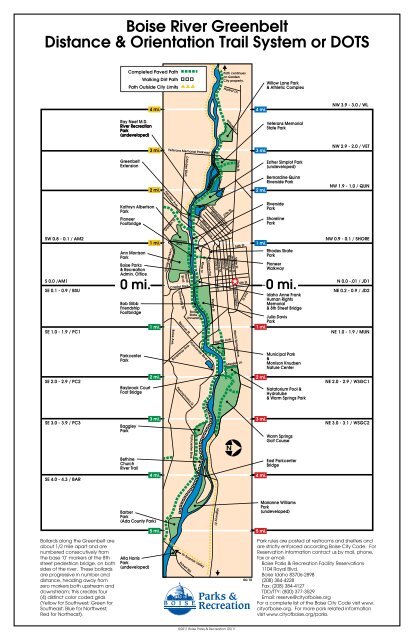
Boise River Greenbelt Distance & Orientation Trail System or DOTS Bollards along the Greenbelt are about 1/2 mile apart and are numbered consecutively from the base ‘0’ markers at the 8th street pedestrian bridge, on both sides of the river. These bollards are progressive in number and distance, heading away from zero markers both upstream and downstream; this creates four (4) distinct color coded grids (Yellow for Southwest; Green for Southeast; Blue for Northwest; Red for Northeast). ©2011 Boise Parks & Recreation 05/11 Park rules are posted at restrooms and shelters and are strictly enforced according Boise City Code. For Reservation information contact us by mail, phone, fax or email: Boise Parks & Recreation Facility Reservations 1104 Royal Blvd. Boise Idaho 83706-2898 (208) 384-4228 Fax: (208) 384-4127 TDD/TTY: (800) 377-3529 Email: reserve@cityofboise.org For a complete list of the Boise City Code visit www. cityofboise.org. For more park related information visit www.cityofboise.org/parks.
<strong>Boise</strong> River <strong>Greenbelt</strong><br />
Distance & Orientation Trail System or DOTS<br />
Bollards along <strong>the</strong> <strong>Greenbelt</strong> are<br />
about 1/2 mile apart and are<br />
numbered consecutively from<br />
<strong>the</strong> base ‘0’ markers at <strong>the</strong> 8th<br />
street pedestrian bridge, on both<br />
sides <strong>of</strong> <strong>the</strong> river. These bollards<br />
are progressive in number and<br />
distance, heading away from<br />
zero markers both upstream and<br />
downstream; this creates four<br />
(4) distinct color coded grids<br />
(Yellow for Southwest; Green for<br />
Sou<strong>the</strong>ast; Blue for Northwest;<br />
Red for Nor<strong>the</strong>ast).<br />
©2011 <strong>Boise</strong> <strong>Parks</strong> & <strong>Recreation</strong> 05/11<br />
Park rules are posted at restrooms and shelters and<br />
are strictly enforced according <strong>Boise</strong> <strong>City</strong> Code. For<br />
Reservation information contact us by mail, phone,<br />
fax or email:<br />
<strong>Boise</strong> <strong>Parks</strong> & <strong>Recreation</strong> Facility Reservations<br />
1104 Royal Blvd.<br />
<strong>Boise</strong> Idaho 83706-2898<br />
(208) 384-4228<br />
Fax: (208) 384-4127<br />
TDD/TTY: (800) 377-3529<br />
Email: reserve@city<strong>of</strong>boise.org<br />
For a complete list <strong>of</strong> <strong>the</strong> <strong>Boise</strong> <strong>City</strong> Code visit www.<br />
city<strong>of</strong>boise.org. For more park related information<br />
visit www.city<strong>of</strong>boise.org/parks.
The Distance & Orientation Trail System or DOTS<br />
The Distance & Orientation Trail System (DOTS) on <strong>the</strong> <strong>Greenbelt</strong> within <strong>Boise</strong><br />
<strong>City</strong> limits is designed to locate points <strong>of</strong> interest and aid in <strong>the</strong> event <strong>of</strong><br />
an emergency. There are 112 spots painted over an 11 mile stretch <strong>of</strong> <strong>the</strong><br />
<strong>Greenbelt</strong> within <strong>the</strong> <strong>Boise</strong> <strong>City</strong> limits from west <strong>of</strong> Lake Harbor to east <strong>of</strong> Warm<br />
Springs Golf Course. The description associated with <strong>the</strong> DOTS system outlined<br />
on this map directs you to <strong>the</strong> section <strong>of</strong> DOTS from <strong>the</strong> nearest street access<br />
(not all descriptions below are shown on <strong>the</strong> map).<br />
NW 4.5 - 4.0 /LH (Not shown on <strong>Map</strong>)<br />
State St. to Market Place Ln., to N. Lake Harbor Ln., Spur just past 2750 N. Lake<br />
Harbor Ln.<br />
NW 3.9 - 3.0 / WL<br />
State St. to Willow Ln., East Willow Lane Athletic Complex through main parking<br />
lot to drive way prior to overflow parking, middle <strong>of</strong> drive way/path.<br />
N. Lander St. through parking lot to <strong>Greenbelt</strong> - spur west side <strong>of</strong> restrooms.<br />
NW 2.9 - 2.0 / VET<br />
State St. to N. Lander St. through parking lot to Greennbelt - spur west side <strong>of</strong><br />
restroom. Wooden bridge is not rated for vehicles, Veterans Memorial Parkway<br />
nor<strong>the</strong>ast side <strong>of</strong> bridge, 27th St. to W. Pleasanton Ave.<br />
NW 1.9 - 1.0 / QUN<br />
27th St. to W. Pleasanton Ave.<br />
Fairview to 30th St., Turn south past Shilo Motel, Fairview to 30th St. turn south<br />
past Shilo Motel. DOTS are in <strong>the</strong> tunnel under Main St.<br />
27th St. to Fletcher St.<br />
NW 0.9 - 0.1 / SHORE<br />
Fire Training Station -1791 W. Shoreline, Northwest <strong>of</strong> Americana, Shoreline Dr.<br />
and S. 13th St. behind Shoreline Park Restrooms, River St. to Pioneer Ave.<br />
NW 0 / Idaho Anne Frank Human Rights Memorial & 8th Street Bridge (Not<br />
shown on <strong>Map</strong>)<br />
Not available for reservations<br />
N 0.0 -.01 / JD1<br />
Capitol Blvd. to Battery St., enter Julia Davis Park South <strong>of</strong> Art Museum. DOTS<br />
under 8th St.<br />
NE 0.2 - 0.9 / JD2<br />
Capitol Blvd. to Battery St., enter Julia Davis Park south <strong>of</strong> Art Museum - end<br />
<strong>of</strong> Capitol Blvd. underpass, across from Zoo road, behind Zoo, behind tennis<br />
courts, enter Julia Davis Park from far east end <strong>of</strong> parking lot at Broadway<br />
underpass.<br />
NE 1.0 - 1.9 / MUN<br />
E. Park Blvd. to S. Ferguson St., Park Blvd. to S. Walnut St., Enter from parking lot<br />
next to N.E. side <strong>of</strong> <strong>the</strong> Parkcenter Blvd. Bridge.<br />
Behind Kimberly One Apartments, S. Walnut St. to enter Municipal Park, enter<br />
path on south side <strong>of</strong> shelter/restroom facility, behind MK Nature Center.<br />
S. Walnut St. enter greenbelt spur from north side <strong>of</strong> Municipal Park.<br />
Warm Springs Ave. to Marden Ln., past United Water.<br />
NE 2.0 - 2.9 / WSGC1<br />
Warm Springs Ave. to Marden Ln., towards Warm Springs Golf Course.<br />
Warm Springs Ave. to E. Walling Dr. to E. Walling Crt.<br />
Warm Springs Golf Course east <strong>of</strong> Pro Shop.<br />
NE 3.0 - 3.1 / WSGC2<br />
Warm Springs Ave. to Warms Springs Golf Course.<br />
To process a request to use <strong>the</strong> <strong>Boise</strong> River <strong>Greenbelt</strong> for a community event or<br />
activity advertised and open to <strong>the</strong> public (fun runs, walks or rallies), contact:<br />
<strong>Boise</strong> <strong>Parks</strong> & <strong>Recreation</strong>, Facility Reservations<br />
1104 Royal Blvd.<br />
<strong>Boise</strong>, Idaho 83706-2898<br />
(208) 608-7600<br />
Fax: (208) 608-7648<br />
TDD/TTY: (800) 377-3529<br />
Email: reserve@city<strong>of</strong>boise.org<br />
Web: www.city<strong>of</strong>boise.org/parks/reservatons<br />
You will be required to complete a Community Park Application and to<br />
identify your route by using this map. O<strong>the</strong>r requirements are outlined in our<br />
Policies for Event Planners. All requests MUST BE received 60 days prior to <strong>the</strong><br />
event for processing.<br />
Scheduled Activities and Areas that are Limited or Prohibited for Use<br />
• A timed or race event that requires riding or operating a skate-<br />
board, roller skates, scooters, inline skates, bicycles or o<strong>the</strong>r wheeled<br />
recreation equipment is prohibited.<br />
• 8th Street Bridge & Idaho Anne Frank Human Rights Memorial and<br />
walking dirt paths are prohibited.<br />
For example<br />
NW 0.5, indicates a<br />
location on <strong>the</strong> north<br />
side <strong>of</strong> <strong>the</strong> river and<br />
east <strong>of</strong> <strong>the</strong> 8th St.<br />
pedestrian bridge by<br />
.5 miles.<br />
For example<br />
SW 0.3, indicates a<br />
location on <strong>the</strong> south<br />
side <strong>of</strong> <strong>the</strong> river and<br />
west <strong>of</strong> <strong>the</strong> 8th St.<br />
pedestrian bridge by<br />
.3 miles.<br />
SW 0.8 - 0.1 / AM2<br />
Americana Blvd., half way between Ann Morrison Park entrance and <strong>Boise</strong><br />
River, close to Candy Cane Playground, 40 yards west <strong>of</strong> Ann Morrison<br />
Footbridge.<br />
9th St. to W. Royal Blvd., entrance at end <strong>of</strong> cul-de-sac behind <strong>Parks</strong> &<br />
<strong>Recreation</strong> Administration Office -1104 Royal Blvd.<br />
W. Royal Blvd. to N. Lusk, East end <strong>of</strong> 9th St. underpass between 9th & Capitol<br />
Blvd.<br />
S 0.0 /AM1 W Royal Blvd. to N. Lusk EAST<br />
East end <strong>of</strong> 9th St. underpass between 9th & Capitol Blvd.<br />
SE 0.1 - 0.9 / BSU<br />
Capitol Blvd. to Campus Dr., DOTS just east <strong>of</strong> Capitol Blvd. underpass,<br />
In front <strong>of</strong> Morrison Center for Performing Arts. DOTS just east <strong>of</strong> BSU & Julia<br />
Davis footbridge.<br />
Capitol Blvd. To Campus Dr. by Amphi<strong>the</strong>ater.<br />
Broadway to Campus Dr., between BSU Stadium and Pavilion,<br />
Northwest end <strong>of</strong> BSU Stadium.<br />
SE 1.0 - 1.9 / PC1<br />
W. Beacon St. to north on S. Leadville Ave., enter at <strong>the</strong> intersection <strong>of</strong> Beacon<br />
St. and Parkcenter Blvd., Entrance on <strong>the</strong> nor<strong>the</strong>ast side <strong>of</strong> parking lot at 220<br />
Parkcenter Blvd., behind Albertson’s Corporate Offices.<br />
E. Parkcenter Blvd. to Baybrook Crt.<br />
SE 2.0 - 2.9 / PC2<br />
E. Parkcenter Blvd. To Baybrook Ct., Parkcenter Blvd. To River Run Dr. to<br />
Riverstone Ln. to <strong>the</strong> Cottonwoods Apartments (foot traffic only or city utility<br />
vehicles only).<br />
Parkcenter Blvd. to River Run Dr. to Riverstone Ln. to <strong>the</strong> Cottonwood<br />
Apartments. Follow easement to <strong>Greenbelt</strong> across wooden bridge.<br />
Parkcenter Blvd. to River Run Dr. turn North on Springbrook Ln., Spur at 1935<br />
Springbrook Ln.<br />
SE 3.0 - 3.9 / PC3<br />
Parkcenter Blvd. to River Run Dr. turn north on Springbrook Ln, Spur at 1935<br />
Springbrook Ln. (Foot Traffic Only).<br />
Parkcenter Blvd. to E. Spring Meadow Ln. (Private Ln), Access point is on <strong>the</strong><br />
N.W. corner <strong>of</strong> intersection at E. Spring Meadow Ln. & S. Swallowtail Ln.<br />
Parkcenter Blvd. between Law Ave. and E. Monterey Dr. Large power line<br />
crosses Parkcenter, north towards <strong>the</strong> <strong>Boise</strong> River, power line corridor leads to<br />
<strong>Greenbelt</strong>.<br />
SE 4.0 - 4.3 / BAR<br />
Parkcenter Blvd. to E. Gossamer Ln. (Private Ln.) 2266 E Gossamen Ln. spur leads<br />
to <strong>Greenbelt</strong> (foot traffic only or city utility vehicles only) at far east end <strong>of</strong><br />
Parkcenter Blvd.<br />
<strong>Boise</strong> River <strong>Greenbelt</strong> Use Request<br />
I hereby certify that I have read all information (front and back) and will<br />
abide by <strong>the</strong> policies set forth by <strong>the</strong> <strong>City</strong> <strong>of</strong> <strong>Boise</strong>, <strong>Boise</strong> <strong>Parks</strong> & <strong>Recreation</strong><br />
Department, and in signing this application, I hereby agree that I and <strong>the</strong><br />
organization I represent, shall hold <strong>the</strong> <strong>City</strong> <strong>of</strong> <strong>Boise</strong> and all <strong>of</strong> its agents or<br />
employees free and harmless from any claim, liability or damage which may<br />
arise from use <strong>of</strong> <strong>City</strong> facilities or equipment. In <strong>the</strong> event <strong>of</strong> joint negligence,<br />
each party will only be responsible to <strong>the</strong> extent <strong>of</strong> <strong>the</strong>ir contribution. I fur<strong>the</strong>r<br />
agree to promptly reimburse <strong>the</strong> <strong>City</strong> <strong>of</strong> <strong>Boise</strong> for any clean up, loss or damage<br />
to <strong>City</strong> property resulting from this use.<br />
Event<br />
Organizer’s<br />
Signature: __________________________________________________________________<br />
Date: ______________________________________________________________________<br />
For more information visit www.city<strong>of</strong>boise.org/parks/reservations<br />
©2011 <strong>Boise</strong> <strong>Parks</strong> & <strong>Recreation</strong> 05/11


