EXPLORERS CLUB FLAG 60 REPORT - The Explorers Club
EXPLORERS CLUB FLAG 60 REPORT - The Explorers Club
EXPLORERS CLUB FLAG 60 REPORT - The Explorers Club

Create successful ePaper yourself
Turn your PDF publications into a flip-book with our unique Google optimized e-Paper software.
<strong>EXPLORERS</strong> <strong>CLUB</strong> <strong>FLAG</strong> <strong>60</strong> <strong>REPORT</strong><br />
Dwelling L.M. i (1)<br />
Archaeological Exploration of Lop Nor Desert Xinjiang, China.<br />
November 17th 2007 – January 1st 2008<br />
Dr. Christoph Baumer, FI’04<br />
President, Society for the Exploration of EurAsia<br />
Fellow of <strong>The</strong> Royal Asiatic Society and of <strong>The</strong> Royal Geographical Society<br />
© Christoph Baumer
Table of Contents Page<br />
I Summary 1<br />
II Introduction & Background 3<br />
III Objectives 4<br />
IV Expedition Members & Areas of Responsibility 4<br />
V Methods 5<br />
VI Expedition Route 6<br />
VII Findings & Results 7<br />
A. Desert Crossing 7- 8<br />
B. Target Area 9-19<br />
VIII Main Conclusions & Open Questions 20<br />
Appendices 21<br />
Endnotes<br />
I Summary<br />
Acknowledgement<br />
Photo Credits<br />
This Flag <strong>60</strong> Report describes the findings from the crossing of the central western part of the Lop Nor<br />
Desert never surveyed so far and from the systematic archaeological exploration of a search area c.<br />
177 sq. km large. <strong>The</strong> two fortresses Haitou (L.K.) and L.M. as well as the settlement L.M., found in<br />
1914 by Sir Aurel Stein, were rediscovered and the alleged existence of another settlement L.R, found<br />
in 1915 by one of Stein’s surveyors, was confirmed. All sites date from the Han (202 BC – 220 AD),<br />
Wei (220-265 AD) and Western Jin Dynasties (263-316 AD).<br />
F.l.t.r. Ernst Rüegg, Dr. Christoph Baumer FI’04, Urs Möckli, Ueli Nüesch (2)<br />
© Christoph Baumer<br />
1
© Natural Vue Copyright MDA Federal Inc.; GAF AG, Munich; Urs Möckli<br />
Desert Taklamakan within the Tarim Basin (3)<br />
2
II Introduction & Background<br />
<strong>The</strong> Lop Nor area forms with its surface of c. 52.000 sq. km the most eastern part of the Taklamakan<br />
Desert in the Uigur Autonomous Region Xinjiang, P.R. China. It is one of the least researched regions<br />
of Central and Eastern Asia due to its hostile environment, harsh climatic conditions and the fact that<br />
the northern edge of Lop Nor was used from 1964 to 1996 for atmospheric and subterranean nuclear<br />
tests.<br />
<strong>The</strong> Lop Nor was partly explored in the first three decades of the 20th century by explorers such as<br />
Sven Hedin, Sir Aurel Stein, Folke Bergman and Parker Chen. From 1935 to 1994 it was closed to<br />
Westerners. As of the 1950s, a few Chinese expeditions went to Loulan L.A. In the late 1970s and early<br />
1980s, important discoveries were made in northern Lop Nor. Namely around Loulan, the discovery<br />
of 4000-years old mummies of Indo-European stock and of the tomb of Yingpan in the north-western<br />
area. <strong>The</strong>n, in 2002-2005, a 4000-3500 years old necropolis was excavated at Xiaohe in the northwestern<br />
corner of Lop Nor. All these discoveries prove that two to four millennia ago the Lop Nor area<br />
was more fertile than today.<br />
Lop Nor and the other eastern parts of the Taklamakan Desert were first home of the Proto-Tocharians,<br />
who were of Indo-European stock and probably migrated before 2000 BC into the Lop Nor area from<br />
Southern Siberia and Western Mongolia. As of the 8./7th centuries BC, Mongolian, and then later,<br />
Chinese people migrated into the region. Most of Lop Nor belonged to the Kingdom of Loulan, which<br />
was subjugated in 176 BC by the Xiongnu of Turco-Mongolian stock and became in 108 BC for the first<br />
time a tributary to China. As of the 4th century AD, most places in the Lop Nor started to be abandoned<br />
due to lack of water, as the River Tarim changed its course of flow around 320-330 AD. After a place<br />
called Yuli, south of today’s Korla, it stopped flowing eastward to Loulan, but flowed southward in the<br />
direction of Qarkilik. <strong>The</strong> oases in Lop Nor were fully dependent from glacial water feeding the Tarim.<br />
Between the 2 nd century BC and the 4 th -5 th centuries AD two of the Silk Road branches passed through<br />
Lop Nor. Both started at the Jade Gate Yumen Guan, 80 km west of present Dunhuang, and ran 380<br />
km westwards to the fortified city of Loulan, Stein’s L.A., where they bifurcated. 1 <strong>The</strong> northern one<br />
followed the ancient River Tarim further westwards and reached the ancient Kingdom of Kuqa, while<br />
the central one headed south-westwards through Lop Nor to Miran and then to Qiemo (Calmadana),<br />
Niya and Khotan. <strong>The</strong> distance between Loulan and Miran was c. 150 km as the crow flies, however<br />
after 55 km trade caravans would reach the two fortresses of L.K. and L.L. <strong>The</strong> original name of L.K. is<br />
revealing, for it means ‘lake’ (hai) ‘head’ (tou), suggesting that Haitou once stood at the south-western<br />
shore of ancient Lake Lop Nor, at whose northern end Loulan was situated.<br />
In addition to the change of flow of the Tarim, the collapse in western China of the regional dynasties<br />
of the Former Liang (320-376 AD) and Later Liang (386-403 AD) further damaged trade on these Silk<br />
Roads.<br />
<strong>The</strong> Uigur hunter Tokhta Akhun first discovered L.K. in 1910 and led Aurel Stein there in February 1914,<br />
following the ancient central Silk Road from Miran to Loulan. Stein briefly investigated L.K. and the<br />
second fortress L.L. as well as a nearby settlement labelled L.M. One year later, his surveyor Afraz Gul<br />
chanced upon a second settlement called L.R. without investigating it. Apart from Afraz Gul, nobody<br />
ever saw L.M. and there existed neither sketch plans nor photographs. 2 <strong>The</strong> only other expedition<br />
able to reach L.K. and L.L. after Stein was a Chinese survey team in 1988, but it failed finding both<br />
settlements. Like Stein, it came from the south. It 1994, Christoph Baumer failed to reach L.K. from the<br />
south due to an accident and missed the site by c. 6 km.<br />
No archaeological expedition ever attempted to reach these four sides from the west and to cross<br />
the central western part of Lop Nor. No map exists of western Lop Nor and Aurel Stein’s maps of the<br />
region between Miran, L.K. and L.A. were useless for our expedition since they are flawed by major<br />
triangulation mistakes affecting longitudinal indications. 3<br />
3
III Objectives<br />
1. To explore the unknown central western part of the Lop Nor Desert between the southern course<br />
of the former River Tarim (dried up in 1921) and the fortress L.K. and to search for possible traces of<br />
ancient trading routes and ruins unknown so far.<br />
2. To find the fortresses L.K. and L.L., and to rediscover the settlements of L.M. and L.R. not visited<br />
since 1914 respectively 1915.<br />
3. To investigate, survey and document these four sites and explore their surroundings.<br />
4. To search for new, unknown ruins and cultural relics, in order to pave the way for future archaeological<br />
expeditions.<br />
5. To contribute to the understanding of the hydrological changes in the western part of Lop Nor which<br />
led to the desertification of this once more fertile region.<br />
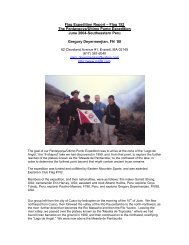
IV Expedition Members & Areas of Responsibility<br />
Dr. Christoph Baumer, Switzerland. Expedition leader, archaeologist and photographer. Leader of<br />
three previous expeditions into the desert Taklamakan 1994, 1998, 2003.<br />
cbaumer@swissonline.ch contact@exploration-eurasia.com<br />
Urs Möckli, Switzerland. Photographer and navigator. Member of the Taklamakan Desert<br />
expedition 1998.<br />
moeckliurs@bluewin.ch<br />
Ueli Nüesch, Switzerland. Film producer and cameraman.<br />
nofilm@gmx.ch 4<br />
Ernst Rüegg, Switzerland. Surveyor. Member of the Taklamakan Desert expedition 1998.<br />
Ernst-rueegg@bluewin.ch<br />
Chinese support team: Organizer/translator, cook, three truck drivers, one mechanic.<br />
<strong>The</strong> team at the end of the expedition (4)<br />
© Christoph Baumer<br />
4
V Methods<br />
Orientation:<br />
Two different satellite pictures were purchased over which a coordinate grid based on the World Geodetic<br />
System WGS 84 was laid:<br />
1. A 15m/pixel Landsat picture of total Lop Nor was used for navigation in the unknown western part<br />
of Lop Nor.<br />
Satellite picture of Lop Nor (5)<br />
© Natural Vue Copyright MDA Federal Inc.; GAF AG, Munich; Urs Möckli<br />
2. A high resolution 63cm/pixel Quickbird picture of the rectangular, c. 177 sq km large search area<br />
defined by the following coordinates:<br />
North/top: N 40° 12’ 00’’/ E 89° 36’ 50’’<br />
East/right: N 40° 07’ 00’’/ E 89° 43’ 70’’<br />
South/bottom: N 40° 02’ 00’’/ East 89° 40’ 25’’<br />
West/left: N 40° 07’ 00’’/ East 89° 33’ 00’’<br />
32 spots were identified for investigation on foot. <strong>The</strong>y were divided between Christoph Baumer, Urs<br />
Möckli and Ernst Rüegg and individually investigated. In order to find the settlements L.M. and L.R.,<br />
certain areas were systematically searched in a close-meshed way.<br />
Logistics:<br />
Due to the length of the expedition, the expected total lack of water and the short duration of daylight,<br />
camels were disregarded as means of transport and special desert trucks were rented from an oil company<br />
based in Korla. <strong>The</strong>y were modified MOL trucks with DEUTZ engines. Everything, including 5000<br />
kg of diesel, had to be brought along.<br />
5
VI Expedition Route<br />
• Beijing – Urumqi (plane) – Korla – Desert Entry Point (Land Cruiser).<br />
• Desert Entry Point - – Search Area L.K./L.L./L.M./L.R. – Tuyin (MOL desert trucks).<br />
• Tuyin – Former Lake Lop Nor – He Zhang – Dunhuang (Donfeng truck, Land Cruiser).<br />
• Dunhuang - Urumqi (train) – Beijing (plane).<br />
Driving in Lop Nor (6)<br />
Searching the way in Lop Nor (7)<br />
© Urs Möckli<br />
© Christoph Baumer<br />
6
VII Findings & Results<br />
A. Desert Crossing<br />
<strong>The</strong> crossing of the western part of the Lop Nor Desert from the Desert Entry Point at N 39° 59’ 17.4”/<br />
E 88° 21’ 49.5” to the first target L.K. stretched over a distance of 113 km as the crow flies and took<br />
us 10 full days of hard work. We started at dawn and stopped at dusk, putting up the tents in the light<br />
of the trucks’ headlights. Progress over the up to 50 m high sand dunes and soft, mesa-like yardangs<br />
– chalk deposits on the bottom of former lakes – was made additionally difficult by the fact that 90%<br />
of the winds blow from the north-east, which means that we had to climb the dunes on the soft lee<br />
side.<br />
•<br />
•<br />
•<br />
10 km east of Desert Entry Point we chanced upon the remains of a 10 x 4 m large stable consisting<br />
of a fence made by poplar branches aligned in straight lines and reed. No objects were found. Since<br />
it stands 10 km from the edge of the desert, it might be c. 200-300 years old.<br />
16 km east of the Desert Entry Point we discovered on a 2 m high elevation the ruin of a small dwelling<br />
10 x 8.5 m in size consisting of two rooms and stables. Based on the scraps of linen and cotton<br />
textiles found, it is judged to be about 300-500 years old. Probably it served as an occasional shelter<br />
for sheep herdsmen as suggested by ancient sheep and goat droppings. Since it practically never<br />
rains in the desert for decades, organic matters remain for centuries. Next to the shelter stood living<br />
tamarisk trees called tograk in Uigur language. 5<br />
About 35 to 40 km east of the Desert Entry Point all life stopped. We saw no traces of fauna, except<br />
the bleached and very worn skulls of two deer, and all flora remaining, e.g. tamarisks and poplars,<br />
were dead. <strong>The</strong>re were even no insects.<br />
• Pieces of petrified horsetails indicate that life flourished in this part of the desert millennia ago.<br />
•<br />
Accumulations of ancient freshwater snails (exact determination of type follows) testify to formerly<br />
flowing and standing waters.<br />
Freshwater snails on the ground of Lop Nor (8)<br />
© Christoph Baumer<br />
7
•<br />
•<br />
<strong>The</strong> fact that we found several times yardangs on the top of lower dunes and not only at their bottom<br />
indicates, that the bottom of the former lake (or lakes) was uneven with elevations up to c. 20-25 m.<br />
Between the shelter and a point 14 km west of L.K., a distance of 83 km as the crow flies, we found<br />
no cultural relic whatsoever, neither ruin, nor shards, nor flints. Also no indicators of an ancient trading<br />
route.<br />
• 14 km west of L.K., the first Neolithic flint was found.<br />
On top of a sand dune (9)<br />
© Christoph Baumer<br />
8
B. Target Area<br />
1. L.K. and surroundings<br />
<strong>The</strong> fortress L.K was found based on the high resolution picture. Along an ancient riverbed, hundreds<br />
of dead poplar trees lined both shores for a length of c. 2 km starting 2.7 km south-west of the fort.<br />
Another long row of dead poplars stands in a similar distance in the south-east of L.K.<br />
<strong>The</strong> fort has an irregular ground shape of c. 190 x 102 m, the walls reached a height of 6.5 to 7 m and<br />
were crowned by a parapet. At their base they are 9.5 m thick, at the top c. 2.3 m. <strong>The</strong> walls are built<br />
of air-dried clay bricks of different sizes ranging from 70 x 50 cm to 50 x 35 cm. Layers of clay alternate<br />
with layers of poplar trunks and tamarisk branches.<br />
Satellite picture of fort L.K. “Haitou” (10)<br />
Fort L.K. seen from the south (11)<br />
© LANDinfo Worldwide mapping LLC; GAF AG, Munich; Urs Möckli<br />
© Christoph Baumer<br />
9
Ceremonial jade axe (14) Christoph Baumer, FI’04, inside Fort L.K. (13)<br />
•<br />
•<br />
•<br />
•<br />
<strong>The</strong> upper third of the southern wall is singed on the outer side; some layers of poplar and tamarisks<br />
have burnt.<br />
Inside L.K., most of the wooden pillars still standing on Steins photograph dating from 1914, have<br />
fallen to the ground. It is unknown if they fell due to Stein’s excavation or due to continued aeolian<br />
erosion.<br />
Like Stein, we found very few relics such as various pottery shards, a stone spindle, a clay spindle,<br />
blue glass beads, a millstone, fragments of coins, 2 ropes made out of camel hair. 6<br />
<strong>The</strong> excavation of a two-storeyed construction north of the eastern gate, which was covered by a<br />
dune at Stein’s time, yielded only minor pieces of cotton textiles, a round granite ball used as a pestle<br />
and dozens of bones from sheep, goats and birds.<br />
• Like Stein, we did not find any inscription on wood, leather, silk or paper.<br />
Inside Fort L.K. (12)<br />
© Urs Möckli<br />
© Urs Möckli<br />
© Christoph Baumer<br />
• Within a 5 km perimeter around L.K were found on the surface: 2 probably ceremonial green jade<br />
axes, a worked piece of yellow serpentine in the shape of a miniature stele, 3 stone spindles, coarse<br />
red, black and grey pottery from the Han (202 BC–220 AD), Wei (220-265 AD) and Western Jin Dynasties<br />
(263-316 AD).<br />
10
© Natural Vue Copyright MDA Federal Inc.; GAF AG, Munich; Urs Möckli<br />
<strong>The</strong> target area of the expedition with all major ruin complexes (15)<br />
11
2. L.L. and surroundings<br />
<strong>The</strong> fortress L.L. lies 5 km north-west of L.K. and is visible with the naked eye from there. It stands <strong>60</strong>0<br />
m south of a dry riverbed. Its construction method is similar to L.K, but its shape is, with c. 67 x 42<br />
m, smaller. On the western side stretches a more than 100 m long dune which the wind has brought<br />
through the large breach in the eastern wall and carried over the western wall.<br />
•<br />
•<br />
•<br />
•<br />
50 m north of L.L. stood an isolated building of unknown function; only a few worked beams remain<br />
on top of a small mesa.<br />
Inside the fort, nothing remains standing. On the eastern side, wooden pillars stemming from the gate<br />
lie on the ground; also on the inner northern part a few worked beams lie on the ground.<br />
Inside L.L. we find: the neck and handle of a red ceramic pot, a wuzhou coin, a bronze heart shaped<br />
locket, a millstone, a black stone spindle, yellow glass beads and apricot kernels.<br />
On the south-eastern part of L.L. stands a separate, probably once two-storeyed construction,<br />
measuring 20 x 20 m. After a 40 cm thick layer of sand only strongly singed wood was brought to<br />
light by the excavation.<br />
Sketch of Fort L.L. (17)<br />
Fort L.L. seen from south-east (16)<br />
© Ernst Rüegg, Urs Möckli<br />
© Christoph Baumer<br />
12
3. L.M. and surroundings<br />
<strong>The</strong> five ruins of the L.M. settlement were not found based on the satellite picture, but by systematic<br />
and close-meshed search on foot. <strong>The</strong>y stretch over a distance of 1670 m along an axis running from<br />
south-east to north-west. A 40 m broad dry riverbed filled with sand separates the most southern<br />
one L.M. i from the other four. 1.5 km east of L.M. i stand parallel rows of apricot trees, an ancient<br />
orchard.<br />
• L.M. i: This large house consisted of a central room of 8x10 m in size and at least two to three lateral<br />
rooms. About 20 m to the south-east stood another construction consisting of one or two rooms.<br />
On the floor lay dozens of thick poplar posts and architraves in the spot where they had once formed<br />
the walls and two column bases with sockets for the pillars that supported the roof. On the ground<br />
we found, among other items, blue and amber glass beads, a large wooden ladle, a piece of woollen<br />
tapestry with geometric patterns in red, blue, orange and yellow, and two pieces of very fine, yellow<br />
glass with a line decoration like a large ‘Z’. <strong>The</strong>y probably belonged to a vessel imported from the<br />
West.<br />
Glass beads, L.M. i (19) Glass fragment, L.M. i (20)<br />
Dwelling L.M.i (18)<br />
© Christoph Baumer © Christoph Baumer<br />
© Christoph Baumer<br />
13
• L.M. ii: Inside the main room (10.8 x 8.1 m) lay four poplar bases with sockets at their original place<br />
indicating where the beams once supported the roof. <strong>The</strong> floor was covered with more than 70 bronze<br />
coins of two types: A few „wuzhou“ coins and mostly Kuqa small coins without inscription which<br />
were cast in the Chinese vassal Kingdom of Kuqa. Also a copper vessel affixed to a hollow bronze<br />
rod was found on the ground, maybe it was part of an oil lamp. Additionally, a 4 cm long, tubular,<br />
greenish-blue glass bead and an aquamarine glass bead consisting of five flattened spheroids clinging<br />
together were found.<br />
Kuqa Wuzhou coins, dwelling L.M. ii (22) Kuqa Wuzhou coins, dwelling L.M. ii (23)<br />
Dwelling L.M. ii (21)<br />
© Christoph Baumer © Christoph Baumer<br />
© Christoph Baumer<br />
14
Christmas in Lop Nor (24)<br />
•<br />
•<br />
•<br />
•<br />
© Urs Möckli<br />
L.M. iii: A few pillars and two bases with sockets remained on the floor; on the top of the 4 m high<br />
mesa lay a very well preserved green jade axe.<br />
L.M. iv: As at L.M. iii, only a few pillars and two bases with sockets remained on the floor. South of<br />
the ruin, the strong winds have eroded the ground 7 m deep.<br />
L.M. v: Also here, only a few pillars and two bases with sockets were left. Both fortresses are visible<br />
from here; the distance to L.K. is 10.8 km.<br />
Other: Small heaps of shards standing between the five ruins indicate either kilns or, more probably,<br />
former dwellings only built out of clay. 450 m south-east of L.M. i, fragments of a c. 10 cm high bronze<br />
pot with fine line and circle decorations were found.<br />
15
4. L.R. and surroundings<br />
<strong>The</strong> three ruins of the L.R. settlement, not visited by Aurel Stein, were not found based on the satellite<br />
picture, but by systematic and close-meshed search on foot.<br />
•<br />
L.R. i: <strong>The</strong> ruin is not a dwelling, as suggested by Stein based on Afraz Gul’s description, but a<br />
beacon tower. It consists of two sections lying on the top of separate small mesas, 3 and 4 metres<br />
high. On the lower one lay fine poplar posts and branches; on the higher one two piles of unusually<br />
thick and long beams, some of which had fallen to the ground. <strong>The</strong>ir shape is not as usual round, but<br />
rectangular or square. <strong>The</strong> top of the mesa is crowned by a 1.5 m high, tight layer of poplar branches<br />
and covered by rough blocks of clay, recalling the construction method used at both fortresses. Two<br />
beams 4.5 metres long had 11 holes and notches, once serving as an architrave and as a lower<br />
cross-beam for the wall-supporting pillars lying next to them. On the western side of the mesa lay<br />
two short beams measuring 85 centimetres, at both ends of which 25 centimetre-long wooden pegs<br />
were stuck. <strong>The</strong>y were two window frames.<br />
Like those standing west of Dunhuang and along the Konqe Darya near Yingpan, this tower would<br />
have consisted of a c. five-metre-high mesa with a room on top, built out of strong wooden beams<br />
and thick layers of mud. <strong>The</strong> only entrance would have been here, reached either by a ladder that<br />
could be lifted, or by a rope. <strong>The</strong> two window frames formed the embrasures for archers. It is the first<br />
beacon tower ever found inside Lop Nor.<br />
Beacon tower L.R. i ( 25)<br />
© Christoph Baumer<br />
16
Site L.R.: f.l.t.r the bottom of tower L.R. i, dwellings L.R ii and L.R. iii (26)<br />
• L.R. ii: At this dwelling, more than 30 wooden posts forming the outer walls are still standing, some<br />
of them badly eroded by the wind. Attached to one huge poplar pillar was its wooden capital with<br />
scroll-shaped brackets at each end cut in one piece, looking similar to a Ionic volute.<br />
Dwelling L.R. iii with freshwater snails in the foreground and a capital on the right. (27)<br />
© Christoph Baumer<br />
© Christoph Baumer<br />
17
• L.R. iii: This large dwelling consists of six rooms and three stables for goats and sheep and for<br />
storing millet and other cereals (we found cereal grains, sheep and goat droppings under the sand).<br />
More than 40 wooden beams are still standing, all of them more or less eroded by the wind. On the<br />
ground lay several dozen beams, all four wooden pillars that had supported the roof, one large base<br />
with socket and two wooden capitals with scroll-shaped brackets at each end cut in one piece. A test<br />
excavation in the main room brought the three remaining bases with sockets to light. <strong>The</strong> first pillar<br />
base was badly weathered, having been exposed to the sun and wind, but the three others were in<br />
pristine condition, preserved by the dry sand, and had kept their original brown-reddish colour. <strong>The</strong><br />
bases were incorporated into the floor, which consisted of a layer of wood covered by rubbish mixed<br />
with straw, for insulation purposes, and finally a thin coat of clay. <strong>The</strong> door sill was found on the<br />
northern side. After the photographic documentation and sketching of the room, it was fully covered<br />
by sand again. In a refuse heap close to the door, eight bronze tacks were found, which would have<br />
been used to fix leather onto the wooden frame of a saddle. On the southern side of the house lay<br />
dozens of freshwater snails on the ground of a long, narrow depression, suggesting still or running<br />
water. (<strong>The</strong> results from the analysis of the snails is still pending.)<br />
Ernst Rüegg (left) draws a sketch of L.R. iii (28)<br />
© Urs Möckli<br />
Others: 1.2 km north-west of L.R. iii, a place was found scattered with dozens of very coarse black,<br />
grey and red pottery shards and a worked flint. No traces of dwellings could be identified. A survey<br />
further north-west yielded no additional findings.<br />
18
5. Other findings<br />
• <strong>The</strong> four sites form a 14.1-kilometre, virtually straight line stretching from L.K. in the south-east to<br />
L.R. in the north-west.<br />
• <strong>The</strong> tower L.R. i and both fortresses had direct contact with each other via smoke and fire signals.<br />
•<br />
•<br />
•<br />
<strong>The</strong> axis of the long side of all dwellings and both forts was oriented to the north-east so that the<br />
winds blowing from there would only hit the short side, causing less damage.<br />
A bronze wuzhou coin from Emperor Zhaodi (ruled 87-74 BC) was found 48 km north-north-east of<br />
L.R. and 15 fragments from a bronze plate or vessel where chanced upon.<br />
All remaining target spots identified on the high resolution satellite picture were either round or rectangular<br />
formation of yardangs or ancient trees which had fallen by chance at a right-angle.<br />
Wuzhou coin of Emperor Zhaodi (ruled 87-74 BC) (29)<br />
Target point 32 with natural formations (30)<br />
© Urs Möckli<br />
© LANDinfo Worldwide mapping LLC; GAF AG, Munich; Urs Möckli<br />
19
VIII Main Conclusions and Open Questions<br />
• No other ruins visible above the ground are expected to be found within the search area.<br />
•<br />
Ancient dry riverbeds, lines of dead poplars and freshwater snails indicate that the region consisted<br />
until c. 1<strong>60</strong>0 years ago of a patchwork of meandering rivers, shallow waters, reed, poplar groves and<br />
spreading sand dunes. It was the lower part of a delta of a tributary of the former River Tarim flowing<br />
until c. 320-330 AD towards Loulan, roughly comparable to the delta of the Okavango in Botswana<br />
in dry seasons.<br />
Dead forest along an ancient riverbed south of L.K. (31)<br />
•<br />
•<br />
•<br />
•<br />
At L.M. and L.R., apricots were grown and probably also millet; sheep and goats were raised. <strong>The</strong><br />
inhabitants probably supplied themselves.<br />
<strong>The</strong> beacon tower L.R. i suggest, that the two settlements were threatened in spite of being close to<br />
both fortresses.<br />
<strong>The</strong> aeolian erosion in Lop Nor is significantly stronger than in the more western parts of the Taklamakan<br />
Desert.<br />
Several questions remain open: Why were two fortresses built so close to each other? Why and when<br />
exactly (probably towards the end of the 4th century AD) where these four sites abandoned? Has<br />
Buddhism reached the sites? (Neither Stein nor we found clear signs apart from a very few scraps of<br />
paper.) Where is the graveyard located?<br />
<strong>The</strong> camp at night (32)<br />
© Christoph Baumer<br />
© Urs Möckli<br />
20
Appendices<br />
Endnotes<br />
1 Stein labelled all ruins he visited in Lop Nor with two letters: <strong>The</strong> first ‘L’ stands for ‘Loulan’ and the<br />
second Stein allocated in the chronological order of his visits.<br />
2 Stein, Marc Aurel, Innermost Asia (Clarendon, Oxford, 1928) pp.180-204, 746.<br />
3 Stein, Marc Aurel and Masson, Major K, Memoir on Maps of Chinese Turkistan and Kansu<br />
(Trigonometrical Survey Office, Dehra Dun, 1923) pp.79, 81, 83, 85, 87, 95.<br />
4 <strong>The</strong> video documentation is as per March 2008 in post-production.<br />
5 As required by the local authorities we do not publish at this time coordinates of cultural relics<br />
found.<br />
6 As agreed with local authorities, we left all findings in situ after photographing them.<br />
Acknowledgement<br />
I would like to thank the following persons whose help was essential:<br />
Mr. Klaus Dobler, Germany, for installing the FUGAWI navigation software on the expedition’s notebook<br />
and for his instructions.<br />
Mr. Felix Neukom from SWISSPHOTO, Switzerland, for putting the coordinate grid over the satellite<br />
pictures.<br />
GAF AG, Munich Germany, for allowing the non-commercial publication of the satellite pictures.<br />
Photo Credits<br />
Christoph Baumer: 1, 2, 4, 7, 8, 9, 11, 12, 16, 18, 19, 20, 21, 22, 23, 25, 26, 27, 31<br />
LANDinfo Worldwide mapping LLC; GAF AG, Munich; Urs Möckli: 10, 30<br />
Natural Vue Copyright MDA Federal Inc.; GAF AG, Munich; Urs Möckli: 3, 5, 15<br />
Urs Möckli: 6, 13, 14, 24, 28, 29, 32<br />
Ernst Rüegg, Urs Möckli: 17<br />
© Christoph Baumer, March 2008<br />
21