

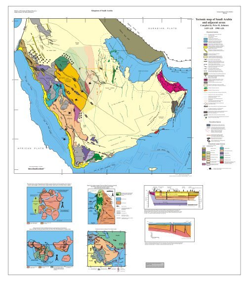
Tectonic map of Saudi Arabia and adjacent areas Kingdom of Saudi ...
Tectonic map of Saudi Arabia and adjacent areas Kingdom of Saudi ...
Tectonic map of Saudi Arabia and adjacent areas Kingdom of Saudi ...

You also want an ePaper? Increase the reach of your titles
YUMPU automatically turns print PDFs into web optimized ePapers that Google loves.
32°<br />
24°<br />
16°<br />
Ministry <strong>of</strong> Petroleum <strong>and</strong> Mineral Resources<br />
Deputy Ministry for Mineral Resources<br />
Gulf <strong>of</strong> Aqaba pull-apart basins<br />
RED<br />
SEA<br />
Dead Sea transform<br />
MIDYAN<br />
Tabuk<br />
Azlam graben<br />
36°<br />
Qazaz gneiss belt<br />
ARCH<br />
Red Sea axial trough<br />
Reconstruction <strong>of</strong> early Neoproterozoic Rodinia supercontinent <strong>and</strong> the possible site <strong>of</strong> origin <strong>of</strong><br />
oceanic assemblages <strong>of</strong> the eventual <strong>Arabia</strong>n-Nubian shield (part <strong>of</strong> the East African orogen)<br />
Possible site <strong>of</strong> origin <strong>of</strong> 870-700<br />
Ma assemblages <strong>of</strong> eventual<br />
East African orogen<br />
Mozambique<br />
ocean<br />
Possible site <strong>of</strong> origin <strong>of</strong> 870-530<br />
Ma assemblages <strong>of</strong> eventual<br />
Trans-Saharan orogen<br />
Archean-Paleoproterozoic<br />
cratonic nuclei (cratons)<br />
MADAGASCAR<br />
KALAHARI<br />
CONGO<br />
INDIA<br />
EAST ANTARCTICA<br />
WEST AFRICA<br />
Grenvillian orogenic belts<br />
(>1100 Ma)<br />
AUSTRALIA<br />
LAURENTIA<br />
AMAZONIA<br />
Equator<br />
BALTICA<br />
Rift zone 750-725 Ma resulting in separation<br />
<strong>of</strong> Laurantia <strong>and</strong> a continental block<br />
that became East Gondwana<br />
SIBERIA<br />
Rift zone separating Laurentia<br />
from a continental block<br />
that became West Gondwana<br />
After H<strong>of</strong>fman (1991), Torsvik <strong>and</strong> others (1996),<br />
<strong>and</strong> Unrug (1997)<br />
Reconstruction <strong>of</strong> the end-Neoproterozoic supercontinent <strong>of</strong> Gondwana<br />
(about 500 Ma) showing the East African <strong>and</strong> other Pan-African/Brasiliano orogenic belts<br />
EAST ANTARCTICA<br />
<strong>Arabia</strong>n-Nubian shield<br />
assembled 715-630 Ma<br />
Equator<br />
AUSTRALIA E a s t G<br />
INDIA o n d<br />
CONGO<br />
w<br />
East<br />
a<br />
African n a<br />
orogen<br />
EAST Trans-<br />
SAHARASaharan<br />
belt<br />
Cimmerian terranes<br />
basin<br />
Tabuk graben<br />
Harrat Uwayrid<br />
Archean-Mesoproterozoic<br />
cratonic nuclei<br />
Fayha graben<br />
TERRANE<br />
Hamadat gneiss belt<br />
Harrat Lunayyir<br />
Al Busayta fault<br />
Avalonian<br />
Wadi as Sirhan<br />
graben<br />
Qur Mulayh <strong>and</strong><br />
Tufayhah grabens<br />
Sirhan-Turayf<br />
Tayma graben<br />
Wajiyah gneiss belt<br />
Al Hamd graben<br />
A F R I C A N P L A T E<br />
t u<br />
u<br />
s<br />
u<br />
b<br />
n<br />
a<br />
Y<br />
r<br />
Scale: approximately 1:4 million<br />
25 0 50 100 150 200 km<br />
e<br />
KALAHARI<br />
W e<br />
WEST<br />
s t G o n<br />
AFRICA<br />
Tuareg shield assembled<br />
about 600 Ma<br />
- Ca<br />
Harrat al Harrah<br />
d<br />
omian<br />
Grenvillian orogenic belts<br />
(>1100 Ma)<br />
Umm Wu'al graben<br />
Al Huj fault zone<br />
An Nafud basin<br />
Bi'r Umq-Nakasib<br />
suture<br />
Ad Damm<br />
fault zone<br />
AMAZONIA<br />
d w a<br />
r<br />
ter<br />
s<br />
e<br />
an<br />
RED<br />
n a<br />
HA'IL<br />
SEA<br />
LAURENTIA<br />
Pan-African-Brasiliano orogenic<br />
belts (mostly collisional); diagonal<br />
denotes east <strong>Arabia</strong>n basement <strong>of</strong><br />
uncertain Pan-African <strong>and</strong>/or older<br />
provenance<br />
Halaban-Zarghat<br />
Ad Dafinah fault<br />
ASIR<br />
BALTICA<br />
fault zone<br />
HIJAZ TERRANE<br />
tectonic significance AFIF<br />
COMPOSITE<br />
TERRANE<br />
JIDDAH<br />
Red Sea axial trough<br />
basin<br />
Wadi as Sirhan fault<br />
Harrat<br />
al Ithnayn<br />
Harrat Khaybar<br />
An Nakhil gneiss belt<br />
Harrat<br />
Rahat<br />
At Tawil fault zone<br />
Rocks <strong>of</strong> uncertain<br />
tectonic affinity<br />
HA'IL<br />
TERRANE<br />
TERRANE<br />
Fault <strong>of</strong> uncertain<br />
Harrat<br />
Al Kishb<br />
Harrat<br />
Hadan<br />
Harrat<br />
Al Birk<br />
42°<br />
Harrat Hutaymah<br />
Harrat<br />
Al Buqum<br />
Farasan<br />
Isl<strong>and</strong>s<br />
42°<br />
Harrat<br />
Nawasif<br />
SP 4<br />
Ruwah<br />
SIBERIA<br />
Al Junaynah fault<br />
COMPOSITE<br />
ARCH<br />
SP 5<br />
Tihama<br />
Asir<br />
complex<br />
SP 6<br />
Tin gneiss belt<br />
TERRANE<br />
Harrat<br />
As Sarat<br />
After H<strong>of</strong>fman (1991) <strong>and</strong> Unrug (1997)<br />
Present-day coastline<br />
(for reference)<br />
Habariyah gneiss belt<br />
fault zone<br />
ARCH<br />
Nabitah<br />
fault zone<br />
Widyan<br />
basin<br />
Kirsh gneiss belt<br />
Ar Rika<br />
SP 3<br />
Hajizah gneiss belt<br />
QASIM DEEP<br />
AD DAWADIMI<br />
fault zone<br />
Yemen Trap series<br />
SP 2<br />
Al Amar fault<br />
AR RAYN<br />
TERRANE<br />
Wajid<br />
basin<br />
Central <strong>Arabia</strong>n graben<br />
TERRANE<br />
40°<br />
30°<br />
20°<br />
10°<br />
<strong>Kingdom</strong> <strong>of</strong> <strong>Saudi</strong> <strong>Arabia</strong><br />
Detail <strong>of</strong> the region between East <strong>and</strong> West Gondwana showing<br />
the tectonic setting <strong>of</strong> the <strong>Arabia</strong>n-Nubian shield<br />
(part <strong>of</strong> the East African orogen)<br />
Early Cambrian ocean<br />
EAST SAHARA<br />
CRATON<br />
Closure <strong>of</strong><br />
West Gondwana<br />
(sense <strong>of</strong> closure<br />
uncertain)<br />
WEST<br />
GONDWANA<br />
30°<br />
CONGO<br />
CRATON<br />
?<br />
Delgo-Atmur<br />
Aswa<br />
TANZANIAN<br />
CRATON<br />
KALAHARI<br />
CRATON ?<br />
Black Sea<br />
Mediterranean<br />
Sea<br />
NAF<br />
EAF<br />
SP 1<br />
ABAS<br />
TERRANE<br />
AL BAYDA<br />
T.<br />
30°<br />
NAF<br />
TURKISH<br />
PLATE<br />
AFRICAN<br />
PLATE<br />
DST<br />
EAF<br />
Nubian<br />
shield<br />
North Anatolian fault<br />
East Anatolian fault<br />
Central<br />
Palmyride<br />
<strong>Arabia</strong>n-<br />
Nubian<br />
shield<br />
Mozambique belt<br />
?<br />
Possible free-board<br />
escape <strong>of</strong> segments<br />
<strong>of</strong> the East African orogen<br />
ARABIA<br />
Ruwah<br />
Ar Rika<br />
MADAGASCAR<br />
SOMALIA<br />
SRI LANKA<br />
INDIA<br />
ANTARCTICA<br />
1000 km<br />
Cimmerian terranes<br />
Basement <strong>of</strong> uncertain<br />
Pan-African <strong>and</strong>/or<br />
older provenance<br />
PAKISTAN<br />
S<br />
Oblique-slip<br />
(transpressional)<br />
closure <strong>of</strong><br />
East Gondwana<br />
KARMAN<br />
Narmada-Son<br />
lineament<br />
EAST GONDWANA<br />
After Stern, 1994<br />
Cenozoic tectonic setting <strong>of</strong> the <strong>Arabia</strong>n plate<br />
40°<br />
<strong>Arabia</strong>n<br />
AL MAHFID<br />
T.<br />
Gulf<br />
<strong>of</strong><br />
itli<br />
B s suture<br />
Palmyra fold<br />
belt<br />
Red Sea uplift<br />
DST<br />
KHABB<br />
20±3 mm/yr<br />
ARABIAN<br />
Red Sea spreading cen<br />
collapse<br />
Red Sea uplift<br />
structure<br />
A<br />
<strong>Arabia</strong>n<br />
shield<br />
40°<br />
50°<br />
EURASIAN<br />
ter<br />
1.6 cm/yr<br />
JAHAM<br />
den<br />
48°<br />
Caspian<br />
Dead Sea transform<br />
Zagros fo<br />
Gulf<br />
<strong>Arabia</strong>n-Nubian shield<br />
Central <strong>Arabia</strong>n<br />
arch<br />
AL MUKALLA<br />
T.<br />
s<br />
pre<br />
Sea<br />
i<br />
ad<br />
Zagros thrust<br />
<strong>Arabia</strong>n Gulf basi n<br />
<strong>Arabia</strong>n platform<br />
PLATE<br />
A r a b i a n G u l f b a s i n<br />
<strong>of</strong><br />
ng<br />
ld belt<br />
Ad<br />
e<br />
n<br />
'AIN DAR<br />
c<br />
50°<br />
60° 70°<br />
sp<br />
3.2 cm/yr<br />
Oman<br />
ophiolite<br />
re<br />
ad<br />
in<br />
ce<br />
g n<br />
Plate movement<br />
Plate boundary<br />
PLATE<br />
2 cm/yr<br />
t<br />
Western Gulf salt basin<br />
Ar Rub al Khali basin<br />
te<br />
r en<br />
SHEDGUM<br />
ABQAIQ<br />
er<br />
INDIAN<br />
PLATE<br />
Makran thrust<br />
e<br />
n<br />
o<br />
z<br />
e<br />
r<br />
actu<br />
fr<br />
n<br />
Owe<br />
Indian Ocean<br />
Zagros fold belt<br />
H a d r a m a u t a r c h e s<br />
East African orogen: Mozambique Belt<br />
<strong>and</strong> <strong>Arabia</strong>n-Nubian shield. Exposed<br />
rocks - dark tone; concealed rocks -<br />
light tone.<br />
West Gondwana<br />
East Gondwana<br />
Plate movement<br />
Continental outline <strong>and</strong>(or) presentday<br />
geographic boundaries<br />
(for reference)<br />
Buried suture<br />
Post-orogenic rift<br />
Strike-slip fault, arrows<br />
show sense <strong>of</strong> movement<br />
Possible eastern <strong>and</strong> western margins<br />
<strong>of</strong> East African orogen<br />
INDIAN<br />
PLATE<br />
60°<br />
Thrust fault<br />
Strike-slip fault<br />
Transform fault<br />
40°<br />
30°<br />
20°<br />
10°<br />
Zagros thrust belt<br />
r<br />
a<br />
t<br />
a<br />
Q<br />
Eastern Gulf salt basin<br />
48° 54°<br />
h<br />
c<br />
r<br />
a<br />
54° 60°<br />
Depth (km) SW<br />
0<br />
10<br />
20<br />
30<br />
40<br />
50<br />
60<br />
70<br />
80<br />
E U R A S I A N P L A T E<br />
Tihama Asir<br />
(Coastal plain)<br />
Khamis Mushayt<br />
gneiss<br />
Coast Red Sea<br />
SP6<br />
line escarpment<br />
SP5<br />
4.2<br />
6.8<br />
8.0<br />
4.2<br />
6.0<br />
6.4<br />
8.0<br />
8.0<br />
Upper mantle<br />
8.1<br />
8.3 8.3<br />
8.3<br />
8.3<br />
8.5<br />
6.3<br />
6.3<br />
6.5<br />
6.7<br />
Seismic-refraction crustal model <strong>of</strong> Mooney <strong>and</strong> others (1985) for the southwestern part <strong>of</strong> the <strong>Arabia</strong>n plate<br />
showing a principal tw<strong>of</strong>old division <strong>of</strong> the crust <strong>and</strong> rapid thinning <strong>of</strong> the crust beneath the coastal plain.<br />
Alternative models for the entire section or part <strong>of</strong> the section given by Prodehl (1985), Milkereit <strong>and</strong> Fluh (1985),<br />
<strong>and</strong> Badri (1991). Seismic-refraction data reported by Healy <strong>and</strong> others (1982); compressional-wave velocities<br />
in km/sec. For location <strong>of</strong> pr<strong>of</strong>ile <strong>and</strong> shot points, see main <strong>map</strong>.<br />
Khuff eroded<br />
Basement high<br />
Ghudun-Khasfah fault<br />
1000<br />
500<br />
0<br />
0<br />
kilometers<br />
50<br />
Basement<br />
Coreldraw6 File: tectonic <strong>map</strong> final PRJ.cdr<br />
August 2, 1997<br />
Prepared as PDF File by A. Serano, October 2000<br />
6.6<br />
Lower Paleozoic succession (Saq-Qalibah)<br />
Al Junaynah<br />
Ar Rika<br />
Al Amar<br />
fault zone<br />
fault zone fault zone Phanerozoic-Neoproterozoic<br />
Nabitah fault Ruwah<br />
contact<br />
SP4<br />
zone fault zone<br />
SP3 SP2 SP1 NE<br />
6.4 6.3 6.2 6.3 6.3 6.1 6.1<br />
Crustal layer 1<br />
Intracrustal reflector<br />
6.2<br />
6.2<br />
6.3 6.3<br />
3.09<br />
6.3 6.2 6.3 6.3 6.1 6.1<br />
6.15<br />
6.5<br />
6.7<br />
6.4<br />
6.4 Continental crust<br />
<strong>of</strong> Precambrian rocks<br />
6.3<br />
6.6<br />
6.8<br />
Crustal layer 2<br />
6.6?<br />
6.8<br />
7.8<br />
7.8<br />
8.0 7.3<br />
8.0<br />
7.3 7.4<br />
8.1<br />
8.1 8.2<br />
WEST<br />
SHEDGUM<br />
EAST<br />
QASIM DEEP KHABB JAHAM 'AIN DAR ABQAIQ<br />
meters<br />
Suneinah trough<br />
100<br />
Fahud<br />
salt basin<br />
South Oman<br />
salt basin<br />
Ghaba salt basin<br />
East Sheba ridge<br />
Khuff<br />
Tertiary monocline<br />
Hawasina thrust sheet<br />
Unayzah<br />
M a k r a n t h r u s t<br />
Masirah trough (Up. Cretaceous <strong>and</strong> Tertiary)<br />
Masirah ophiolite zone;<br />
sinistral obduction (thrusting)<br />
Section in central <strong>Saudi</strong> <strong>Arabia</strong> showing "Hercynian" structures in the Lower Paleozoic succession <strong>and</strong> basement<br />
caused by pre-Unayzah Devonian extension. The Lower Paleozoic strata are eroded over structural highs <strong>and</strong><br />
preserved in structural basins. For location <strong>of</strong> section <strong>and</strong> bore holes see main <strong>map</strong>.<br />
Aru<br />
ma<br />
tr<br />
oug<br />
h (<br />
Salakh arch<br />
Fiqa<br />
for<br />
Maradi fault zone<br />
ela<br />
nd<br />
bas<br />
in)<br />
Huqf axis<br />
8.3<br />
8.5<br />
Datum: Khuff D anhydrite<br />
Masirah transform fault<br />
n<br />
e<br />
w<br />
O<br />
8.1<br />
8.3<br />
e<br />
n<br />
o<br />
z<br />
e<br />
r<br />
u<br />
t<br />
c<br />
a<br />
r<br />
f<br />
National boundary approximate<br />
o<br />
Lambert conformal conic projection, st<strong>and</strong>ard parallels 17 <strong>and</strong> 33<br />
6.4<br />
After McGillivray <strong>and</strong> Husseini, 1992<br />
7.0<br />
o<br />
32°<br />
24°<br />
16°<br />
MOHO<br />
Technical Report USGS-TR-98-3<br />
(IR 948)<br />
<strong>Tectonic</strong> <strong>map</strong> <strong>of</strong> <strong>Saudi</strong> <strong>Arabia</strong><br />
<strong>and</strong> <strong>adjacent</strong> <strong>areas</strong><br />
6.5<br />
6.8<br />
6.4<br />
0 100<br />
200 km<br />
Compiled by Peter R. Johnson<br />
1419 A.H 1998 A.D.<br />
0<br />
10<br />
20<br />
30<br />
40<br />
50<br />
60<br />
70<br />
80<br />
Depth (km)<br />
Phanerozoic features<br />
Red Sea <strong>and</strong> Gulf <strong>of</strong> Aden axial trough<br />
(spreading center)<br />
Steep bathymetric gradient<br />
(probable fault)<br />
Possible mixed oceanic <strong>and</strong><br />
continental crust <strong>of</strong> northern Red Sea<br />
Oceanic crust <strong>of</strong> southern Red Sea <strong>and</strong><br />
Gulf <strong>of</strong> Aden, partly covered by Cenozoic<br />
sediments; boundaries approximate<br />
Proto-oceanic crust exposed on the <strong>Saudi</strong><br />
<strong>Arabia</strong>n coastal plain (Tihama Asir complex)<br />
Unnamed terranes in the<br />
basement <strong>of</strong> central <strong>Arabia</strong><br />
Surface<br />
extent<br />
QASIM DEEP<br />
Exposed Cretaceous, Paleogene, <strong>and</strong> Neogene<br />
sedimentary deposits <strong>of</strong> the Red Sea basin;<br />
local paleohighs <strong>and</strong> horst blocks <strong>of</strong> Precambrian<br />
rocks not shown<br />
Paleogene <strong>and</strong> Neogene pull-apart basins<br />
<strong>and</strong> grabens asociated with Red Sea extension<br />
Cenozoic flood-basalt associated<br />
with Red Sea extension<br />
Paleogene-Neogene sedimentary rocks<br />
exposed in the central <strong>Arabia</strong>n shield <strong>and</strong><br />
partly concealed by Cenozoic flood basalt<br />
Normal faults <strong>of</strong> the Sa'dah graben<br />
High, continuous Red Sea escarpment<br />
(Oligocene to present) south <strong>of</strong> Ad Damm fault;<br />
equivalent Gulf <strong>of</strong> Aden escarpment not shown<br />
Central <strong>Arabia</strong>n collapse structure<br />
caused by dissolution <strong>of</strong> near-surface evaporites<br />
Faults <strong>of</strong> the Central <strong>Arabia</strong>n graben system<br />
(Late Tertiary to Holocene)<br />
Gulf <strong>of</strong> Aden collapse structures<br />
associated with Gulf <strong>of</strong> Aden extension<br />
Normal faults associated with Cretaceous<br />
<strong>and</strong> Tertiary basins flanking the Gulf <strong>of</strong> Aden<br />
Post-collisional Zagros fold belt (Miocene-Pliocene)<br />
Zagros thrust belt (Eocene-Miocene): collisional<br />
suture between the Eurasian <strong>and</strong> <strong>Arabia</strong>n plates;<br />
dashed where submerged<br />
Mesozoic anticlinal highs<br />
Hawasina <strong>and</strong> Semail thrust sheets in Oman:<br />
Cretaceous obduction <strong>of</strong> oceanic crust <strong>and</strong><br />
associated rocks<br />
East Oman (Masirah) ophiolite complex<br />
Phanerozoic sedimentary rocks <strong>of</strong> the <strong>Arabia</strong>n<br />
platform, unconformable on Precambrian basement<br />
Oil fields in Mesozoic reservoirs<br />
Oil fields in Paleozoic reservoirs<br />
Outcrop trace <strong>of</strong> pre-Upper Cretaceous disconformity<br />
Outcrop trace <strong>of</strong> pre-Jurassic disconformity<br />
Outcrop trace <strong>of</strong> pre-Upper Permian<br />
pre-Khuff) disconformity<br />
Outcrop trace <strong>of</strong> pre-Cambrian-Ordovician<br />
disconformity<br />
Concealed, pre-Unayzah (Hercynian) faults;<br />
locally reactivated during the Triassic<br />
Pre-Unayzah basement subcrop (subsurface);<br />
Lower Paleozoic high<br />
Region showing effects <strong>of</strong> Lower Paleozoic glaciation<br />
Concealed salt deposits in end-Precambrian<br />
-Cambrian pull-apart basins (failed rifts)<br />
End-Precambrian-Cambrian volcano-sedimentary rocks in<br />
failed rifts on the <strong>Arabia</strong>n shield (Jibalah group)<br />
<strong>and</strong> in Oman (Huqf group)<br />
Transform fault; arrows show sense <strong>of</strong> movement<br />
Line <strong>of</strong> section <strong>and</strong> bore holes showing Devonian "Hercynian"<br />
structure in central <strong>Saudi</strong> <strong>Arabia</strong><br />
Precambrian features<br />
Schist <strong>and</strong> gneiss in brittle-ductile transcurrent<br />
shear zones <strong>and</strong> terrane sutures<br />
Transcurrent brittle-ductile shear zone (in<br />
part reactivated terrane suture); dashed<br />
where inferred beneath Phanerozoic cover<br />
Region <strong>of</strong> Group III evolved leadisotopes<br />
in Afif terrane; possibly<br />
reflecting continental microplate<br />
Suspect terrane boundary, dashed<br />
where inferred; locally reactivated<br />
by northwest-trending strike-slip faults<br />
Sense <strong>of</strong> horizontal movement on<br />
Precambrian sutures <strong>and</strong> faults<br />
Sense <strong>of</strong> displacement <strong>of</strong> the Afif terrane<br />
relative to the Asir terrane<br />
Precambrian suspect terranes<br />
Possible extension beneath<br />
Phanerozoic cover<br />
Midyan terrane<br />
Hijaz terrane<br />
Ha'il terrane<br />
Afif composite terrane<br />
Ad Dawadimi terrane<br />
Ar Rayn terrane<br />
Unnamed suspect terranes<br />
in central <strong>Arabia</strong><br />
Suspect terrane east <strong>of</strong><br />
the Nabitah fault zone<br />
SP 3<br />
Surface<br />
extent<br />
Jiddah terrane<br />
Asir composite terrane<br />
Abas terrane<br />
Al Bayda terrane<br />
Al Mahfid terrane<br />
Al Mukalla terrane<br />
Metamorphic <strong>and</strong> igneous rocks<br />
<strong>of</strong> possible Neoproterozoic<br />
provenance in Oman<br />
Location <strong>of</strong> shot points <strong>and</strong> seismic-refraction survey<br />
in western <strong>Saudi</strong> <strong>Arabia</strong>
Summary<br />
Ministry <strong>of</strong> Petroleum <strong>and</strong> Mineral Resources<br />
Deputy Ministry for Mineral Resource<br />
TECTONIC MAP OF SAUDI ARABIA AND ADJACENT AREAS<br />
Compiled by: Peter R. Johnson<br />
1419 A.H. 1998 A.D.<br />
<strong>Tectonic</strong>ally, <strong>Saudi</strong> <strong>Arabia</strong> is part <strong>of</strong> the <strong>Arabia</strong>n plate, one <strong>of</strong> over ten lithospheric plates that make up the Earth’s surface. It consists <strong>of</strong> crystalline Precambrian basement overlain<br />
by low-dipping Phanerozoic sedimentary <strong>and</strong> volcanic rocks, <strong>and</strong> originated 25-30 million years ago as a consequence <strong>of</strong> rifting along the line <strong>of</strong> the eventual Red Sea <strong>and</strong> Gulf <strong>of</strong><br />
Aden. The plate moved north <strong>and</strong> collided with the Eurasian plate. Prior to rifting, the rocks <strong>of</strong> <strong>Saudi</strong> <strong>Arabia</strong> were contiguous with those <strong>of</strong> Northeast Africa <strong>and</strong> the Horn <strong>of</strong><br />
Africa, <strong>and</strong> shared the geologic history <strong>of</strong> those regions. Precambrian rocks that crop out in the western third <strong>of</strong> <strong>Saudi</strong> <strong>Arabia</strong> <strong>and</strong> in <strong>adjacent</strong> parts <strong>of</strong> Yemen <strong>and</strong> Jordan comprise<br />
an area referred to as the <strong>Arabia</strong>n shield. Precambrian rocks also crop out locally in Oman <strong>and</strong>, on the basis <strong>of</strong> geophysical measurements, borehole intersections, <strong>and</strong> the character<br />
<strong>of</strong> deep crustal material ejected from Cenozoic volcanoes are inferred to exist as crystalline basement beneath the Phanerozoic sedimentary rocks that occupy central <strong>and</strong> eastern<br />
<strong>Arabia</strong>.<br />
Judging from available isotopic ages, the basement is mainly Neoproterozoic (850-550 Ma), but locally older. It consists <strong>of</strong> deformed <strong>and</strong> metamorphosed volcanic <strong>and</strong><br />
sedimentary rocks, which were deposited in volcanic arcs, sedimentary basins, half-grabens <strong>and</strong> other types <strong>of</strong> complex oceanic environments, <strong>and</strong> vast amount <strong>of</strong> granitic, dioritic<br />
<strong>and</strong> other igneous rock. These rocks were formed during a process <strong>of</strong> crustal accretion that, starting with juvenile oceanic crust <strong>and</strong> possible continental microplates, resulted in<br />
the creation <strong>of</strong> new continental lithosphere about 40–45 km thick. By the end <strong>of</strong> the Precambrian, this crustal layer, which is subdivided into an upper section <strong>of</strong> volcanic,<br />
sedimentary, <strong>and</strong> igneous, mainly granitic, rocks, <strong>and</strong> a lower section <strong>of</strong> mainly mafic rocks, each about 20 km thick, was sutured between the cratons <strong>of</strong> West <strong>and</strong> East Gondwana.<br />
The Phanerozoic geologic history <strong>of</strong> <strong>Saudi</strong> <strong>Arabia</strong> is marked by a moderate degree <strong>of</strong> tectonism in the Precambrian basement <strong>and</strong> the formation <strong>of</strong> a succession <strong>of</strong> arches,<br />
basins, <strong>and</strong> fault blocks. Coupled with the rise <strong>and</strong> fall <strong>of</strong> sea level in the flanking Tethys ocean <strong>and</strong> the epeirogenic effect <strong>of</strong>, <strong>of</strong>ten distant, plate movements, these structures<br />
controlled sedimentation <strong>of</strong> the Phanerozoic rocks, resulting in the development <strong>of</strong> the unconformities, systematic sequence thickenings <strong>and</strong> thinning, <strong>and</strong> facies migrations that<br />
characterize much <strong>of</strong> the Phanerozoic succession in <strong>Arabia</strong>.<br />
Younger tectonic events in <strong>Saudi</strong> <strong>Arabia</strong> reflect Cenozoic rifting, plate movement, <strong>and</strong> associated geologic phenomena. These include the eruption <strong>of</strong> large fields <strong>of</strong> flood<br />
basalt in western <strong>Arabia</strong>, uplift <strong>of</strong> the basement <strong>areas</strong> flanking the rift zones, <strong>and</strong> the development <strong>of</strong> juvenile oceanic floor in the Red Sea <strong>and</strong> Gulf <strong>of</strong> Aden basins. Collision with<br />
Eurasia caused folding <strong>and</strong> thrusting in the Zagros <strong>and</strong> Bitlis zones along the northeastern <strong>and</strong> northern margins <strong>of</strong> the <strong>Arabia</strong>n plate, <strong>and</strong> concurrent strike-slip faulting on the Dead<br />
Sea transform caused the development <strong>of</strong> pull-apart basins <strong>and</strong> en echelon folds.<br />
INTRODUCTION<br />
The study <strong>of</strong> tectonics deals with the broad architecture <strong>of</strong> the outer part <strong>of</strong> the Earth, <strong>and</strong> the age, relationship, <strong>and</strong><br />
evolution <strong>of</strong> regional structural, deformational, <strong>and</strong> crustal features. This <strong>map</strong> shows selected tectonic elements <strong>of</strong> <strong>Saudi</strong><br />
<strong>Arabia</strong> <strong>and</strong>, in lesser detail, elements in <strong>adjacent</strong> parts <strong>of</strong> the <strong>Arabia</strong>n Peninsula. The <strong>map</strong> is modeled on the pioneering<br />
publication by Brown (1972), but itself is a new <strong>map</strong> incorporating geologic <strong>and</strong> geophysical information <strong>and</strong> plate-tectonic<br />
<strong>and</strong> terrane-agglomeration concepts acquired <strong>and</strong> developed since 1972, including those based on the author’s own field<br />
work in the western part <strong>of</strong> <strong>Saudi</strong> <strong>Arabia</strong>. It depicts tectonic relations that began to evolve in the Archean, but continue to<br />
evolve because <strong>of</strong> ongoing deformational activity at the margins <strong>of</strong>, <strong>and</strong> within, the confines <strong>of</strong> the region shown.<br />
Acknowledgements<br />
This <strong>map</strong> was compiled under Subproject 4.1.1.2 (Compilation <strong>of</strong> small-scale geologic <strong>map</strong>s) <strong>of</strong> the <strong>Saudi</strong> <strong>Arabia</strong>n<br />
Deputy Ministry for Mineral Resources Work Program for 1417-1418 (1997). The author is thankful for the continued<br />
support <strong>of</strong> the Deputy Minister, H.E. Ibrahim bin Ahmed Khaberi, <strong>and</strong> the Assistant Deputy Minister for Survey <strong>and</strong><br />
Exploration, H.E. Dr. Mohammed bin Assad Tawfiq. The compiler acknowledges the work <strong>of</strong> earlier geologists who worked<br />
in the region, including Glen Brown, Richard Powers, Jaques Delfour, Mohammed Al-Shanti, Robert Stern, Robert Bohannon,<br />
William Greenwood, Douglas Stoeser, Victor Camp, John Stacey, Robert Agar, Moujahed Husseini, <strong>and</strong> Ramon Loosveld<br />
<strong>and</strong> his colleagues. The present <strong>map</strong> draws on the results <strong>of</strong> these authors, but incorporates them with the compiler’s own<br />
interpretation, so that the final content <strong>of</strong> the <strong>map</strong> is the author’s own. Victor Yuga <strong>and</strong> Marco Marasigan are thanked for<br />
help <strong>and</strong> advice about the digital format <strong>and</strong> presentation <strong>of</strong> this <strong>map</strong>, <strong>and</strong> Timothy Hayes (USGS) is thanked for his technical<br />
review.<br />
ARABIAN PLATE<br />
<strong>Saudi</strong> <strong>Arabia</strong> is part <strong>of</strong> the <strong>Arabia</strong>n plate, one <strong>of</strong> over ten rigid lithospheric plates that make up the surface <strong>of</strong> the<br />
earth. The <strong>Arabia</strong>n plate came into existence 25-30 million years ago (25-30 Ma), when the rocks that comprise what is now<br />
the <strong>Arabia</strong>n Peninsula, Syria, Jordan, Iraq, <strong>and</strong> westernmost Iran began to separate from the African continent because <strong>of</strong><br />
rifting along the margin <strong>of</strong> northeast Africa <strong>and</strong> the opening up <strong>of</strong> the Red Sea <strong>and</strong> Gulf <strong>of</strong> Aden. Although relatively young<br />
as a tectonic unit, the plate incorporates rocks that have evolved over a considerable span <strong>of</strong> geologic history. These rocks<br />
range in age from the Archean to the most recent <strong>and</strong> make up a layer <strong>of</strong> continental crust as much as 45 km thick. The<br />
Precambrian rocks are extensively exposed in the southwest <strong>of</strong> the plate, <strong>and</strong> locally in the southeast, because <strong>of</strong> Mesozoic<br />
<strong>and</strong> Cenozoic uplift. Elsewhere the Precambrian rocks are concealed by a low-dipping sequence <strong>of</strong> Phanerozoic (Infracambrian-<br />
Tertiary) deposits that, in the <strong>Arabia</strong>n Gulf, for example, reach a thickness <strong>of</strong> more than 10 km. The presence <strong>of</strong> Precambrian<br />
basement, where concealed, is attested by the extension <strong>of</strong> magnetic anomalies from <strong>areas</strong> <strong>of</strong> exposure into <strong>areas</strong> <strong>of</strong> concealment,<br />
by gravity data, by seismic surveys, <strong>and</strong> by widely scattered borehole intersections.<br />
The Precambrian rocks contain most <strong>of</strong> <strong>Saudi</strong> <strong>Arabia</strong>’s known metal deposits, such as gold, silver, copper, zinc,<br />
iron, <strong>and</strong> magnesium. The Phanerozoic rocks contain the oil resources <strong>and</strong> deposits <strong>of</strong> bauxite (the source <strong>of</strong> aluminum),<br />
phosphate, clay, limestone, silica s<strong>and</strong>, light weight aggregate, <strong>and</strong> other mineral commodities that are <strong>of</strong> increasing importance<br />
to the industrial development <strong>of</strong> the <strong>Kingdom</strong>.<br />
Since its creation, the <strong>Arabia</strong>n plate moved northeast away from Egypt <strong>and</strong> Sudan, north away from Somalia, <strong>and</strong><br />
rotated counterclockwise about a point in the vicinity <strong>of</strong> the Gulf <strong>of</strong> Suez. Such movement is accommodated by compression<br />
<strong>and</strong> strike-slip faulting along the Bitlis <strong>and</strong> Zagros zones, where the <strong>Arabia</strong>n plate collides with <strong>and</strong> subducts beneath the<br />
Eurasian plate, <strong>and</strong> by strike-slip displacement along the Dead Sea transform. At the present time, the northern part <strong>of</strong> the<br />
<strong>Arabia</strong>n plate moves northwest, with respect to the Eurasian plate, at a rate <strong>of</strong> 20±3 mm/yr. Because they are regions <strong>of</strong><br />
extension, the southern, south-western, <strong>and</strong> southeastern margins <strong>of</strong> the <strong>Arabia</strong>n plate have weak to moderate earthquake<br />
activity; the compressive northerly <strong>and</strong> northeasterly margins, conversely, are regions <strong>of</strong> strong earthquake activity. Overall,<br />
the plate has moved as much as 350 km away from Africa, depending on where the margins <strong>of</strong> the initial rift are placed with<br />
respect to present-day exposure <strong>of</strong> Precambrian basement, depending on how much stretched continental crust is believed to<br />
remain in the Red Sea basin, <strong>and</strong> depending on how much hybrid continental-oceanic <strong>and</strong> true oceanic crust is inferred<br />
beneath the Red Sea shelves <strong>and</strong> axial trough. Displacement along the Dead Sea transform separating the northeastern-most<br />
part <strong>of</strong> the African plate from the <strong>Arabia</strong>n plate <strong>and</strong> linking extension in the Red Sea with compression in the Bitlis zone, is<br />
believed to be about 110 km.<br />
A seismic-refraction survey in southwestern <strong>Saudi</strong> <strong>Arabia</strong> indicates that the <strong>Arabia</strong>n-plate lithosphere broadly<br />
consists <strong>of</strong> two layers, each about 20 km thick. The MOHO, at the base <strong>of</strong> the lower layer separating the continental crust<br />
from upper mantle is 40-45 km below the surface over most <strong>of</strong> the survey area, shallowing rapidly beneath the coastal plain<br />
in the transition zone between continental <strong>and</strong> oceanic crust at the southeastern <strong>and</strong> southern margins <strong>of</strong> the plate. The<br />
uppermost layer is characterized by an average compressional-wave velocity <strong>of</strong> 6.3 km/s <strong>and</strong> probably consists <strong>of</strong> the types<br />
<strong>of</strong> deformed Precambrian rocks exposed at the present-day surface together with vast amounts <strong>of</strong> granitic rock. If the<br />
structure <strong>of</strong> these deformed rocks resembles that <strong>of</strong> orogenic belts elsewhere in the world, the exposed Precambrian volcanic<br />
<strong>and</strong> sedimentary rocks possibly extend only 5-15 km below the surface, bottoming in deeper intrusions or at subhorizontal<br />
faults, <strong>and</strong> constituting ro<strong>of</strong> pendants or thrust sheets. The deeper layer has an average velocity <strong>of</strong> 7.0 km/s, suggesting that<br />
it is mafic in composition, consistent with the composition <strong>of</strong> fragments <strong>of</strong> deep crustal material brought to the surface by<br />
Cenozoic volcanic eruptions in several places in the western part <strong>of</strong> the <strong>Arabia</strong>n plate.<br />
PRECAMBRIAN BASEMENT<br />
The southwestern outcropping Precambrian rocks constitute a region <strong>of</strong> exposed basement called the <strong>Arabia</strong>n shield<br />
(the term shield meaning an exposed area <strong>of</strong> crystalline, stable to moderately stable basement). Most <strong>of</strong> the rocks are<br />
between 870 <strong>and</strong> 550 million years old, although some contain material as much as 2000 million years old. The older<br />
material consists <strong>of</strong> zircon grains, eroded from even older continental crust <strong>and</strong> incorporated as detrital grains into younger<br />
sedimentary <strong>and</strong> plutonic rocks, <strong>and</strong> rare intact old rock. Terranes in Yemen locally contain 2300 Ma Archean gneiss. The<br />
Afif composite terrane in <strong>Saudi</strong> <strong>Arabia</strong> contains inherited zircons, possible intact Paleoproterozoic-Archean rock, <strong>and</strong> feldspar<br />
<strong>and</strong> galena crystals that contain lead isotopes indicating derivation from an evolved continental source, types <strong>of</strong> data that all<br />
suggest the terrane incorporates a continental microplate (now largely destroyed by later intrusion).<br />
The 870-550 Ma rocks <strong>of</strong> the shield represent one <strong>of</strong> the best exposed <strong>and</strong> largest assemblages <strong>of</strong> Neoproterozoic<br />
rocks in the world. Following current ideas about the evolution <strong>of</strong> orogenic belts worldwide, these rocks are divided into<br />
separate crustal units, or suspect terranes, believed to have distinct, unique geologic histories. Many <strong>of</strong> the Neoproterozoic<br />
rocks accumulated in oceanic environments as isl<strong>and</strong> arcs, ocean plateaux, <strong>and</strong> mid-ocean ridges. Reconstructions <strong>of</strong><br />
Precambrian geography suggest that this ocean lay on the margins <strong>of</strong> Rodinia, the global supercontinent that existed during<br />
the early Neoproterozoic. Rodinia began to break up about 750 Ma, <strong>and</strong> rifted segments <strong>of</strong> the supercontinent reassembled<br />
by the end <strong>of</strong> the Neoproterozoic forming a new supercontinent <strong>of</strong> Gondwana. In this process, the basement rocks <strong>of</strong> <strong>Saudi</strong><br />
<strong>Arabia</strong>, together with those <strong>of</strong> northeast Africa <strong>and</strong> those along strike in the Mozambique belt, were caught between western<br />
<strong>and</strong> eastern segments <strong>of</strong> Gondwana as the segments came together, forming a belt <strong>of</strong> folded, thrusted, <strong>and</strong> metamorphosed<br />
agglomerated terranes <strong>and</strong> reworked older rocks (the East African orogen) sutured to Africa (on the west, in present-day<br />
directions) <strong>and</strong> East Gondwana (on the east). Toward the end <strong>of</strong> this process, additional volcanic <strong>and</strong> sedimentary rocks<br />
were deposited in marine <strong>and</strong> continental environments, <strong>and</strong> a vast amount <strong>of</strong> plutonic rock was intruded into <strong>and</strong> beneath<br />
the deformed volcanic <strong>and</strong> sedimentary rocks. Sutures between the constituent terranes <strong>of</strong> the <strong>Arabia</strong>n shield <strong>and</strong> its counterpart<br />
in northeast Africa are marked by serpentinite-decorated faults, thrusts, <strong>and</strong> brittle-ductile shear zones. These faults <strong>and</strong><br />
shear zones coincide with zones <strong>of</strong> significant changes in gravity, magnetic, structural, isotopic, <strong>and</strong> geochronologic<br />
characteristics from one side to the other. Free-board segments <strong>of</strong> the newly formed crust partly escaped collision during the<br />
end Proterozoic <strong>and</strong> early Cambrian by displacement along transcurrent faults <strong>and</strong> by extension across normal faults. These<br />
faults have a range <strong>of</strong> ages <strong>and</strong> histories, but together represent a period <strong>of</strong> failed rifting or dismemberment <strong>of</strong> the newly<br />
formed <strong>Arabia</strong>n crust. Neoproterozoic rocks crop out in Oman, <strong>and</strong> on the basis <strong>of</strong> their magnetic signature <strong>and</strong> rare borehole<br />
intersections, appear to extend some distance from the margins <strong>of</strong> the shield beneath Phanerozoic cover. The exact age<br />
<strong>and</strong> provenance <strong>of</strong> the concealed basement rocks, however, are uncertain.<br />
PHANEROZOIC COVER<br />
Despite being referred to, where exposed, as a shield, the crystalline basement <strong>of</strong> <strong>Saudi</strong> <strong>Arabia</strong> has not been<br />
completely stable since the end <strong>of</strong> crust-forming events in the Precambrian. It has been affected, in response to plate<br />
movements during the ongoing history <strong>of</strong> Gondwana <strong>and</strong> other parts <strong>of</strong> the world, by strike-slip faulting <strong>and</strong> rifting,<br />
forming grabens, <strong>and</strong> by uplift <strong>and</strong> subsidence, forming domes, basins, arches, <strong>and</strong> troughs. The effects <strong>of</strong> such deformation<br />
are considerable. The crest <strong>of</strong> the Ha’il arch is about 4 km above the trough <strong>of</strong> the An Nafud basin; crystalline rocks in the<br />
easternmost part <strong>of</strong> the <strong>Arabia</strong>n plate are depressed beneath more than 10 km <strong>of</strong> sedimentary rocks; crystalline rocks in the<br />
western part <strong>of</strong> the plate are elevated by as much as 3 km along the Red Sea escarpment; basement rocks are vertically<br />
displaced as much as 3 km on buried faults beneath central <strong>Arabia</strong>; <strong>and</strong> the southeastern margin <strong>of</strong> the plate has been<br />
overthust by slices <strong>of</strong> ocean floor. The present-day <strong>Arabia</strong>n shield is exposed because <strong>of</strong> uplift along the Ha’il arch <strong>and</strong><br />
Red Sea arch, <strong>and</strong> the shield is partly concealed, between the arches, by Lower Paleozoic <strong>and</strong> Upper Cretaceous-Paleogene<br />
sedimentary rocks <strong>and</strong> Cenozoic volcanic rocks preserved in a north-south structural low.<br />
The Infracambrian-Phanerozoic sedimentary history <strong>of</strong> <strong>Arabia</strong> began with the deposition, in grabens or pullapart<br />
basins formed by the end Proterozoic faulting mentioned above, <strong>of</strong> clastic rocks <strong>and</strong> later evaporites (Huqf <strong>and</strong><br />
Haima groups) in Oman <strong>and</strong> eastern <strong>Arabia</strong> <strong>and</strong> <strong>of</strong> clastic rocks, limestone, basalt, <strong>and</strong> rhyolite (Jibalah group) on the<br />
exposed shield, <strong>and</strong> the formation <strong>of</strong> the Dokhan Volcanics <strong>and</strong> associated dike swarms in the Egyptian Eastern Desert.<br />
The resulting large Infracambrian-Cambrian salt basins are a conspicuous feature <strong>of</strong> the eastern part <strong>of</strong> the <strong>Arabia</strong>n plate<br />
<strong>and</strong> structures formed by later halokinesis, locally in conjunction with basement horst blocks, make extremely valuable oil<br />
traps. The South Gulf basin contains piercements rimmed by Cretaceous-Tertiary synclines. Farther north, the North Gulf<br />
basin contains large pillows <strong>and</strong> swells. The South Oman <strong>and</strong> Ghaba basins were affected by Lower Paleozoic halokinesis<br />
<strong>and</strong> the Ghaba basin by renewed diapirism in the Mesozoic, particularly during the Late Cretaceous <strong>and</strong> Tertiary concurrent<br />
with the second Alpine event in Eurasia.<br />
During the Early Paleozoic, central <strong>Arabia</strong> was a stable subsiding passive margin flanking Gondwana. Shallowmarine,<br />
littoral, <strong>and</strong> fluvial s<strong>and</strong>stone, siltstone, <strong>and</strong> shale were deposited on the low-relief erosion surface formed on the<br />
Precambrian basement at the end <strong>of</strong> the Neoproterozoic, a depositional cycle interrupted during the Late Ordovician-Early<br />
Silurian by polar glaciation (<strong>Arabia</strong> at this time was within 30° <strong>of</strong> the South Pole). Sea-level rise <strong>and</strong> fall caused regression<br />
<strong>and</strong> transgression <strong>of</strong> the ocean flanking Gondwana <strong>and</strong> a corresponding migration <strong>of</strong> sedimentary facies on the stable<br />
shelf.<br />
Because <strong>of</strong> “Hercynian” orogenic activity that originated beyond the confines <strong>of</strong> Gondwana, the passive margin<br />
<strong>of</strong> Gondwana in <strong>Arabia</strong> during the Devonian became active <strong>and</strong> central <strong>Arabia</strong> underwent uplift <strong>and</strong> tilting. A regional<br />
structural high that lacks Devonian sedimentary rocks marks the early development <strong>of</strong> the Central <strong>Arabia</strong>n arch. Earlier<br />
deposits were depressed in fault basins or eroded across generally north-trending horst blocks resulting in an irregular<br />
topography preserved beneath the Unayzah-Khuff unconformity <strong>and</strong> resulting in the initiation <strong>of</strong> structures that eventually<br />
controlled the location <strong>of</strong> Paleozoic-hosted oil fields in central <strong>Arabia</strong>. Unayzah Formation clastic rocks, which constitute<br />
major oil reservoirs where they overlie appropriate Hercynian structures, mark a resumption <strong>of</strong> sedimentation in the Late<br />
Carboniferous. Deposition <strong>of</strong> the Khuff Formation, representing the earliest major carbonate unit in <strong>Arabia</strong>, followed,<br />
concurrent with rifting <strong>and</strong> Gondwana breakup in the Zagros region. Deep-water sedimentary(radiolarites) <strong>and</strong> tholeiitic/<br />
alkaline volcanic rocks, now cropping out in the Hawasina thrust sheets in Oman, indicate the onset <strong>of</strong> Late Permian<br />
ocean-crust formation in Neo-Tethys. Structural highs developed in Oman as a possible effect <strong>of</strong> thermal-doming prior to<br />
Gondwana breakup. During this period, a second episode <strong>of</strong> glaciation deposited Permo-Carboniferous glaciogenic<br />
clastic rocks in southwestern Ar Rub al Khali <strong>and</strong> in interior Oman<br />
The Mesozoic geologic history <strong>of</strong> the <strong>Arabia</strong>n plate is marked by the formation <strong>of</strong> structural highs <strong>and</strong> lows. In<br />
central <strong>Arabia</strong>, regional extension caused by continued breakup <strong>of</strong> Gondwana <strong>and</strong> rifting along the Zagros belt resulted in<br />
the Triassic reactivation <strong>of</strong> Hercynian structures <strong>and</strong> synsedimentary thinning <strong>of</strong> Triassic deposits over growth faults.<br />
Reactivated basement structures, shown in <strong>Saudi</strong> <strong>Arabia</strong> as N-S Mesozoic anticlinal highs, affected younger sedimentation,<br />
particularly during the Late Cretaceous, causing anticlinal drape folds <strong>and</strong> helping to create the Mesozoic oil fields <strong>of</strong><br />
<strong>Saudi</strong> <strong>Arabia</strong>. The reservoir rocks are Jurassic <strong>and</strong> Cretaceous, into which Jurassic hydrocarbons migrated during the<br />
Tertiary. The axial region <strong>of</strong> the Central <strong>Arabia</strong>n arch underwent Middle Jurassic <strong>and</strong> Early Cretaceous inversion <strong>and</strong><br />
became a basin, followed by reformation <strong>of</strong> the arch during the Late Cretaceous as a consequence <strong>of</strong> uplift in southern<br />
<strong>Arabia</strong> <strong>and</strong> continued subsidence to the north. Similarly labeled Mesozoic anticlinal highs are important tectonic elements<br />
in the Hadramaut region <strong>of</strong> Yemen <strong>and</strong> Oman; they trend E-W <strong>and</strong> reperesent broad arches that were initiated in the<br />
Mesozoic, even possibly in the Paleozoic, <strong>and</strong> were active into the Tertiary. Farther southeast, the precursor <strong>of</strong> the Gulf <strong>of</strong><br />
Aden, the proto-Owen basin, opened in the Jurassic, <strong>and</strong> tilting <strong>and</strong> uplift affected coastal Oman during the onset <strong>of</strong><br />
separation <strong>of</strong> India-Madagascar-Antarctica from Africa-<strong>Arabia</strong> <strong>and</strong> formation <strong>of</strong> the Masirah oceanic crust. These oceanic<br />
rocks were later obducted in the Masirah ophiolite zone. During the Middle Cretaceous, concurrent with the opening <strong>of</strong><br />
the Atlantic, Neo-Tethys closed, <strong>and</strong> the African-<strong>Arabia</strong>n <strong>and</strong> Eurasian plates converged. The Semail ophiolite, created<br />
by back-arc spreading at a subduction zone between the approaching plates, began to thrust over eastern Oman. Obduction<br />
<strong>of</strong> the ophiolite <strong>and</strong> loading <strong>of</strong> the <strong>Arabia</strong>n plate caused an initial bulge <strong>and</strong> a later downwarp in the forel<strong>and</strong> in advance<br />
<strong>of</strong> the thrust. The resulting Aruma trough (Fiqa forel<strong>and</strong> basin) flanked the southwestern margin <strong>of</strong> the Hawasina <strong>and</strong><br />
Semail thrust sheets. The Semail ophiolite was in place by the Late Cretaceous at which time the southeastern coast <strong>of</strong><br />
Oman was affected by sinistral transpression<br />
TERTIARY SPREADING, UPLIFT, AND VOLCANISM<br />
The present-day boundary between the <strong>Arabia</strong>n <strong>and</strong> African plates is a series <strong>of</strong> troughs 2,000-4,500 m deep along<br />
the Red Sea, Gulf <strong>of</strong> Aden, <strong>and</strong> Gulf <strong>of</strong> Aqaba reflecting spreading along the Red Sea <strong>and</strong> Gulf <strong>of</strong> Aden <strong>and</strong> pull-apart<br />
basins along the Dead Sea transform fault. Seafloor spreading in the Red Sea began 5-6 m.y. ago, although an earlier<br />
episode <strong>of</strong> spreading may have occurred 15-25 m.y. ago. Intrusion <strong>of</strong> magma along the spreading axes created the oceanic<br />
crust <strong>of</strong> the southern Red Sea <strong>and</strong> formed pools <strong>of</strong> metal-laden brine <strong>and</strong> hot springs in particular deeps. The floor <strong>of</strong> the<br />
northern Red Sea may be a mixture <strong>of</strong> rifted continental crust <strong>and</strong> newly formed oceanic crust. Syn- <strong>and</strong> post-rift sedimentary<br />
rocks, including evaporites, flank the spreading axis in the Red Sea <strong>and</strong> underlie the Red Sea coastal plain (Tihama). In<br />
most localities, the contact between Precambrian rocks <strong>of</strong> the shield <strong>and</strong> Cenozoic rocks <strong>of</strong> the Red Sea basin is faulted.<br />
The Gulf <strong>of</strong> Aqaba pull-apart basins contain sedimentary rocks. Ocean crust in the Gulf <strong>of</strong> Aden began to form 11 million<br />
years ago (Middle Miocene) by westward propagation from the Carlsbad ridge in the Indian Ocean. The ocean crust is<br />
progressively younger toward to west, <strong>and</strong> is about 2 million years old where propagating west in Djibouti toward the Afar<br />
hot spot.<br />
Processes related to spreading caused uplift <strong>of</strong> the southwestern <strong>and</strong> southeastern margin <strong>of</strong> the <strong>Arabia</strong>n plate<br />
forming mountains in western <strong>Saudi</strong> <strong>Arabia</strong> <strong>and</strong> Hadramaut that crest at the erosional escarpment (2500-3300 m above sea<br />
level) inl<strong>and</strong> from the Red Sea <strong>and</strong> Gulf <strong>of</strong> Aden. According to fission-track data, the Red Sea margin <strong>of</strong> southern <strong>Saudi</strong><br />
<strong>Arabia</strong> has undergone 2.5-4 km uplift in the last 13.8 million years. East <strong>of</strong> the Red Sea escarpment <strong>and</strong> north <strong>of</strong> the<br />
Hadramaut escarpment the l<strong>and</strong> surface slopes to a broad plateau 900-1,000 m above sea level, <strong>and</strong> farther east slopes<br />
gently to the Gulf. End-Cretaceous-Tertiary events in the southeastern part <strong>of</strong> the <strong>Arabia</strong>n plate include oblique obduction<br />
<strong>of</strong> the Masirah ophiolite (Paleocene) onto the <strong>Arabia</strong>n continent <strong>and</strong> rift-shoulder uplift <strong>and</strong> normal faulting <strong>of</strong> coastal<br />
southern Oman <strong>and</strong> eastern Yemen. This episode <strong>of</strong> uplift caused development <strong>of</strong> the Gulf <strong>of</strong> Aden collapse structures,<br />
fractures parallel <strong>and</strong> oblique to the general trend <strong>of</strong> the gulf that deform the edge <strong>of</strong> the uplifted plateau <strong>and</strong> the southern<br />
flanks <strong>of</strong> the Mesozoic Hadramaut arches.<br />
Flood basalt erupted in western <strong>Arabia</strong> as a result <strong>of</strong> the spreading process forming large fields <strong>of</strong> subaerial<br />
volcanic rock (harrats) that cover parts <strong>of</strong> the shield <strong>and</strong> some Phanerozoic sedimentary rocks. The volcanic rocks are<br />
mainly alkali-olivine basalt <strong>and</strong> form lava fields that were extruded from numerous vents <strong>and</strong> volcanic cones. The northerly<br />
alignment <strong>of</strong> cones <strong>and</strong> faults in the volcanic fields possibly reflects a northerly alignment <strong>of</strong> fractures in the underlying<br />
crystalline basement along which magma rose from great depth. The oldest flood basalts are in Yemen <strong>and</strong> southern <strong>Saudi</strong><br />
<strong>Arabia</strong> (30 Ma); the youngest are in parts <strong>of</strong> Harrat Rahat <strong>and</strong> Khaybar (erupted as recently as 700 years ago).<br />
SELECTED BIBLIOGRAPHY<br />
Agar, R.A., 1992, The Tectono-metallogenic evolution <strong>of</strong> the <strong>Arabia</strong>n shield: Precambrian Research, v. 58, p. 169-94.<br />
Al-Saad, D., Sawaf, T. Gebran, A., Barazangi, M., Best, J.A., <strong>and</strong> Chaimov, T.A., 1991, Northern <strong>Arabia</strong>n platform transect across the<br />
Palmyride Mountain Belt, Syrian Arab Republic: Washington, D.C., International Union Commission on the Lithosphere <strong>and</strong><br />
American Geophysical Union, Global Science Transect 1, 5 p.<br />
Al-Sawari, A.M., 1980, Tertiary faulting beneath Wadi al Batin (Kuwait): Geological Society <strong>of</strong> America Bulletin, v. 91, p. 610-18.<br />
Ayers, M.G., Bilal, M., Jones, R.W., Slentz, L.W. Tartir, M., <strong>and</strong> Wilson, A.O., 1982, Hydrocarbon habitat in main producing <strong>areas</strong>, <strong>Saudi</strong><br />
<strong>Arabia</strong>: American Association <strong>of</strong> Petroleum Geologists Bulletin, v. 66, p. 1-9.<br />
Badri, M., 1991, Crustal structure <strong>of</strong> central <strong>Saudi</strong> <strong>Arabia</strong> determined from seismic refraction pr<strong>of</strong>iling: Tectonophysics, v. 185, p. 357-<br />
74.<br />
Beauchamp, W.H., Ries, A.C., Coward, M.P., <strong>and</strong> Miles, J.A., 1995, Masirah graben, Oman: A hidden Cretaceous rift basin: American<br />
Association <strong>of</strong> Petroleum Geologists, v. 79, p. 864-79.<br />
Beydoun, Z.R., 1982, The Gulf <strong>of</strong> Aden <strong>and</strong> northwest <strong>Arabia</strong>n Sea, in A.E.M. Nairn <strong>and</strong> F.G. Stehli, The Ocean Basins <strong>and</strong> Margins, vol.<br />
6, The Indian Ocean, New York <strong>and</strong> London, Plenum Press, p. 253-313.<br />
Blank, H.R., 1977, Aeromagnetic <strong>and</strong> geologic study <strong>of</strong> Tertiary dikes <strong>and</strong> related structures on the <strong>Arabia</strong>n margin <strong>of</strong> the Red Sea: <strong>Saudi</strong><br />
<strong>Arabia</strong>n Directorate General <strong>of</strong> Mineral Resources Bulletin 22, p. G1-G18.<br />
Bohannon, R.G., 1989, Style <strong>of</strong> extensional tectonism during rifting, Red Sea <strong>and</strong> Gulf <strong>of</strong> Aden: Journal <strong>of</strong> African Earth Sciences, v. 8,<br />
p. 589-602.<br />
Bohannon, R.G., Naeser C.W., Schmidt, D.L., <strong>and</strong> Zimmerman, R.A., 1989, The timing <strong>of</strong> uplift, volcanism, <strong>and</strong> rifting peripheral to the<br />
Red Sea: a case for passive rifting? Journal <strong>of</strong> Geophysical Research, v. 94, p. 1683-1701.<br />
Brown, G.F., 1972, <strong>Tectonic</strong> <strong>map</strong> <strong>of</strong> the <strong>Arabia</strong>n Peninsula: <strong>Saudi</strong> <strong>Arabia</strong>n Directorate General <strong>of</strong> Mineral Resources <strong>Arabia</strong>n Peninsula<br />
Map AP-2, scale 1:4,000,000.<br />
Cole, G.A., Carrigan, W.J., Aoudeh, S.M., Abu-Ali, M.A., Tobey, M.H., <strong>and</strong> Halpern, H.I., 1994, Maturity modelling <strong>of</strong> the basal Qusaiba<br />
source rock, northwestern <strong>Saudi</strong> <strong>Arabia</strong>: <strong>Arabia</strong>n Journal for Science <strong>and</strong> Engineering, v. 19, p. 249-71.<br />
Coleman, R.G., 1993, Geologic evolution <strong>of</strong> the Red Sea: New York, Oxford University Press, Oxford Monographs on Geology <strong>and</strong><br />
Geophysics 24, 186 p.<br />
Fantozzi, P.L., 1996, Transition from continental to oceanic rifting in the Gulf <strong>of</strong> Aden: structural evidence from field <strong>map</strong>ping in Somalia<br />
<strong>and</strong> Yemen: Tectonophysics, v. 259, p. 285-311.<br />
Garfunkel, Z., 1981, Internal structure <strong>of</strong> the Dead Sea leaky transform fault (rift) in relation to plate kinematics: Tectonophysics, v. 80,<br />
p. 81-108.<br />
Gettings, M.E., Blank, H.R., <strong>and</strong> Mooney, W.D., 1986, Crustal structure <strong>of</strong> southwestern <strong>Saudi</strong> <strong>Arabia</strong>: Journal <strong>of</strong> Geophysical Research,<br />
v. 91, p. 6491-6512.<br />
Girdler, R.W., 1980, The Dead Sea transform fault system: Tectonophysics, v. 180, p. 1-13.<br />
Girdler, R.W., <strong>and</strong> Styles, P., 1974, Two-stage Red Sea floor spreading: Nature, v. 247, p.1.<br />
Gorin, G.E., Racz, L.G., <strong>and</strong> Walter, M.R., 1982, Late Precambrian-Cambrian sediments <strong>of</strong> Huqf group, Sultanate <strong>of</strong> Oman: American<br />
Association <strong>of</strong> Petroleum Geologists, v. 66, p. 2609-2627.<br />
Hancock, P.L., Al-Kadhi, A., <strong>and</strong> Sha’at, N.A., 1984, Regional joint sets in the <strong>Arabia</strong>n Platform as indicators <strong>of</strong> intraplate processes:<br />
<strong>Tectonic</strong>s, v. 3, p. 27-43.<br />
Healy, J.H., Mooney, W.D., Blank, H.R.Jr., Gettings, M.E., Kholer, W.M., Lamson, R.J., <strong>and</strong> Leone, L.E., 1982, <strong>Saudi</strong> <strong>Arabia</strong>n Seismic<br />
deep-refraction pr<strong>of</strong>ile: Final project report: <strong>Saudi</strong> <strong>Arabia</strong>n Deputy Ministry for Mineral Resources Open-file Report USGS-OF-<br />
02-37, 429 p.<br />
H<strong>of</strong>fman, P.F., 1991, Did the breakout <strong>of</strong> Laurentia turn Gondwana inside-out?: Science, v. 252, p. 1409-12.<br />
Husseini, M.I., 1988, The <strong>Arabia</strong>n Infracambrian extensional system: Tectonophysics, v. 148, p. 93-103.<br />
Husseini, M.I., 1991, <strong>Tectonic</strong> <strong>and</strong> depositional model <strong>of</strong> the <strong>Arabia</strong>n <strong>and</strong> adjoining plates during the Silurian-Devonian: American<br />
Association <strong>of</strong> Petroleum Geologists, v. 75, p. 108-20.<br />
Johnson, P.R., 1093, A preliminary lith<strong>of</strong>acies <strong>map</strong> <strong>of</strong> the <strong>Saudi</strong> <strong>Arabia</strong>n shield: <strong>Saudi</strong> <strong>Arabia</strong>n Deputy Ministry for Mineral Resources<br />
Technical Record RF-TR-03-2, scale 1:1,000,000, 72 p.<br />
Johnson, P.R., Scheibner, E., <strong>and</strong> Smith, E.A., 1987, Basement fragments, accreted tectonostratigraphic terranes, <strong>and</strong> overlap sequences;<br />
elements in the tectonic evolution <strong>of</strong> the <strong>Arabia</strong>n shield: Washington, D.C., American Geophysical Union Geodynamics Series<br />
v. 19, p. 323-43.<br />
Johnson, P.R., <strong>and</strong> Stewart, I.C.F., 1995, Magnetically inferred basement structure in central <strong>Saudi</strong> <strong>Arabia</strong>: Tectonophysics, v. 245, p. 37-<br />
52.<br />
Johnson, P.R., <strong>and</strong> Vranas, G.J., 1984, The origin <strong>and</strong> development <strong>of</strong> late Proterozoic rocks <strong>of</strong> the <strong>Arabia</strong>n shield: <strong>Saudi</strong> <strong>Arabia</strong>n Deputy<br />
Ministry for Mineral Resources Open-file Report RF-OF-04-32, 96 p.<br />
Kashai, E.L., <strong>and</strong> Croker, P.F., 1987, Structural geometry <strong>and</strong> evolution <strong>of</strong> the Dead Sea-Jordan rift system as deduced from new subsurface<br />
data: Tectonophysics, v. 141, p. 33-60.<br />
Loosveld, R.J.H., Bell, A., <strong>and</strong> Terken, J.J.M., 1996, The tectonic evolution <strong>of</strong> Interior Oman,: Geoarabia, v. 1, p. 28-51.<br />
Manetti, P., Capaldi, G., Chiesa, S., Civetta, l. Contocelli, S., Gasparon, M., La Volpe, L., <strong>and</strong> Orsi, G., 1991, Magmatism <strong>of</strong> the eastern<br />
Red Sea margin in the northern part <strong>of</strong> Yemen from Oligocene to present: Tectonophysics, v. 198, p. 181-202.<br />
McGillivary, J.G., <strong>and</strong> Husseini, M.I., 1992, The Paleozoic petroleum geology <strong>of</strong> central <strong>Arabia</strong>: American Association <strong>of</strong> Petroleum<br />
Geologists Bulletin, v. 76, p. 1473-1490.<br />
McGuire, A.V., <strong>and</strong> Stern, R.J., 1993, Granulite xenoliths from western <strong>Saudi</strong> <strong>Arabia</strong>: the lower crust <strong>of</strong> the late Precambrian <strong>Arabia</strong>n-<br />
Nubian Shield: Contributions to Mineralogy <strong>and</strong> Petrology, v. 114, p. 395-408.<br />
Milkereit, B., <strong>and</strong> Fluh, E.R., 1985, <strong>Saudi</strong> <strong>Arabia</strong>n refraction pr<strong>of</strong>ile: Crustal structure <strong>of</strong> the Red Sea-<strong>Arabia</strong>n shield transition:<br />
Tectonophysics, v. 111, p. 283-98.<br />
Mooney, W.D., Gettings, M.E., Blank, H.R., <strong>and</strong> Healy, J.H., 1985, <strong>Saudi</strong> <strong>Arabia</strong>n seismic-reflection pr<strong>of</strong>ile: a traveltime interpretation<br />
<strong>of</strong> crustal <strong>and</strong> upper mantle structure: Tectonophysics, v. 111, p. 173-246.<br />
Murris, R.J., 1980, Middle East: stratigraphic evolution <strong>and</strong> oil habitat: American Association <strong>of</strong> Petroleum Geologists Bulletin, v. 64, p.<br />
597-618.<br />
Powers, R.W., Ramirez, L.F., Redmond, C.D., <strong>and</strong> Elberg, E.L., Jr., 1966, Geology <strong>of</strong> the <strong>Arabia</strong>n Peninsula: Sedimentary geology <strong>of</strong><br />
<strong>Saudi</strong> <strong>Arabia</strong>: U.S. Geological Survey Pr<strong>of</strong>essional Paper, 560-D, 147 p.<br />
Prodehl, C., 1985, Interpretation <strong>of</strong> a seismic-refraction survey across the <strong>Arabia</strong>n shield in western <strong>Saudi</strong> <strong>Arabia</strong>: Tectonophysics, v. 111,<br />
p. 247-82.<br />
Prodehl, C., <strong>and</strong> Mechie, J., 1991, Crustal thinning in relationship to the evolution <strong>of</strong> the Afro-<strong>Arabia</strong>n rift system: a review <strong>of</strong> seismicrefraction<br />
data: Tectonophysics, v. 198, p. 311-27.<br />
Robertson, A.H.F., Searle, M.P., <strong>and</strong> Ries, A.C., editors, 1990, The geology <strong>and</strong> tectonics <strong>of</strong> the Oman region: Geological Society London<br />
Special Publication , no. 49, 845 p.<br />
Reches, Z., <strong>and</strong> Schubert, G., 1987, Models <strong>of</strong> post-Miocene deformation <strong>of</strong> the <strong>Arabia</strong>n plate: <strong>Tectonic</strong>s, v. 6, p. 707-25.<br />
Reilinger, R.E., McClusky, S.C., Oral, M.B., King, R.W., Totsoz, M.N., Barka, A.A., Kinik,I., Lenk, O., <strong>and</strong> Sanli, I., 1997, Global<br />
positioning system measurements <strong>of</strong> present-day crustal movements in the <strong>Arabia</strong>-Africa-Eurasia plate collision zone: Journal <strong>of</strong><br />
Geophysical Research, v. 102, p. 9983-99.<br />
Snyder, D.B., <strong>and</strong> Barazangi, M., 1986, Deep crustal structure <strong>and</strong> flexures <strong>of</strong> the <strong>Arabia</strong>n plate beneath the Zagros collisional mountain<br />
belt as inferred from gravity observations: <strong>Tectonic</strong>s, v. 5, p. 361-73.<br />
Stern, R.J., 1994, Arc assembly <strong>and</strong> continental collision in the Neoproterozoic East African orogen: Implications for the consolidation <strong>of</strong><br />
Gondwanal<strong>and</strong>: Annual Review <strong>of</strong> Earth <strong>and</strong> Planetary Science, v. 22, p. 319-51.<br />
Stewart, I.C.F., Connally, T.C., <strong>and</strong> Copley, J.H., 1996, Stratigraphic interpretation <strong>of</strong> magnetotelluric data in central <strong>Saudi</strong> <strong>Arabia</strong>:<br />
Geoarabia, v. 1, p. 52-62.<br />
Stoeser, D.B., <strong>and</strong> Camp, E., 1985, Pan-African microplate accretion <strong>of</strong> the <strong>Arabia</strong>n shield: Geological Society <strong>of</strong> America Bulletin, v.<br />
96, p. 817-826.<br />
Stoeser, D.B., <strong>and</strong> Stacey, J.S., 1988, Evolution, U-Pb geochronology, <strong>and</strong> isotope geology <strong>of</strong> the Pan-African Nabitah orogenic belt <strong>of</strong><br />
the <strong>Saudi</strong> <strong>Arabia</strong>n shield, in S. El-Gaby <strong>and</strong> R.O. Greiling, The Pan-African belt <strong>of</strong> northeast Africa <strong>and</strong> <strong>adjacent</strong> <strong>areas</strong>:<br />
Braunschweig/Wiesbaden, Vieweg, p. 227-88.<br />
Torsvik, T.H., Smethurst, M.A., Meert, J.G., Van der Voo, R., McKerrow, W.S., Brasier, M.D., Sturt, B.A., <strong>and</strong> Walderhaug, H.J., 1996,<br />
Continental break-up <strong>and</strong> collision in the Neoproterozoic <strong>and</strong> Paleozoic - A tale <strong>of</strong> Baltica <strong>and</strong> Laurentia: Earth-Science Reviews,<br />
v. 40, p. 229-58.<br />
Unrug, R., 1997, Rodinia to Gondwana: The geodynamic <strong>map</strong> <strong>of</strong> Gondwana supercontinent assembly, GSA Today, v. 7, p. 1-6.<br />
Vaslet, D., 1990, Upper Ordovician glacial deposits in <strong>Saudi</strong> <strong>Arabia</strong>: Episodes, v. 13, p. 147-61.<br />
Vaslet, D., Al-Muallem, M.S., Maddah, S.S., Brosse, J.M., Fourniguet, J., Breton, J.P., <strong>and</strong> Le Nindre, Y.M., 1991, Geologic <strong>map</strong> <strong>of</strong> the<br />
Ar Riyad quadrangle, sheet 24 I, <strong>Kingdom</strong> <strong>of</strong> <strong>Saudi</strong> <strong>Arabia</strong>: <strong>Saudi</strong> <strong>Arabia</strong>n Directorate General <strong>of</strong> Mineral Resources Geoscience<br />
Map GM-121, scale 1:250,000, 54 p.<br />
Visser, W., 1991, Burial <strong>and</strong> thermal history <strong>of</strong> Proterozoic source rocks in Oman: Precambrian Research, v. 54, p. 15-36.<br />
Voggenreiter, W., Hotzl, H., <strong>and</strong> Mechie, J., 1988, Low-angle detachment origin for the Red Sea rift system?: Tectonophysics, v. 150, p.<br />
51-75.<br />
DEPUTY MINISTRY FOR MINERAL RESOURCES TECHNICAL REPORT USGS-TR-98-3 (IR-948)
