Nomination of
Nomination of
Nomination of

Create successful ePaper yourself
Turn your PDF publications into a flip-book with our unique Google optimized e-Paper software.
SURTSEY – NOMINATION FOR THE UNESCO WORLD HERITAGE LIST<br />
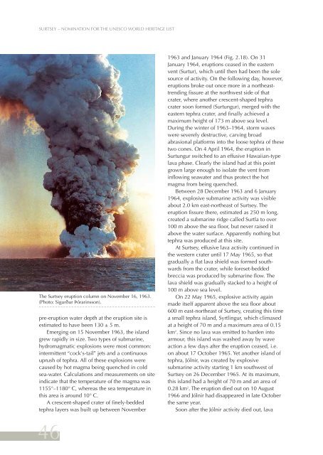
The Surtsey eruption column on November 16, 1963.<br />
(Photo: Sigurður Þórarinsson).<br />
pre-eruption water depth at the eruption site is<br />
estimated to have been 130 ± 5 m.<br />
Emerging on 15 November 1963, the island<br />
grew rapidly in size. Two types <strong>of</strong> submarine,<br />
hydromagmatic explosions were most common:<br />
intermittent “cock's-tail” jets and a continuous<br />
uprush <strong>of</strong> tephra. All <strong>of</strong> these explosions were<br />
caused by hot magma being quenched in cold<br />
sea-water. Calculations and measurements on site<br />
indicate that the temperature <strong>of</strong> the magma was<br />
1155°–1180° C, whereas the sea temperature in<br />
this area is around 10° C.<br />
A crescent-shaped crater <strong>of</strong> finely-bedded<br />
tephra layers was built up between November<br />
46<br />
1963 and January 1964 (Fig. 2.18). On 31<br />
January 1964, eruptions ceased in the eastern<br />
vent (Surtur), which until then had been the sole<br />
source <strong>of</strong> activity. On the following day, however,<br />
eruptions broke out once more in a northeasttrending<br />
fissure at the northwest side <strong>of</strong> that<br />
crater, where another crescent-shaped tephra<br />
crater soon formed (Surtungur), merged with the<br />
eastern tephra crater, and finally achieved a<br />
maximum height <strong>of</strong> 173 m above sea level.<br />
During the winter <strong>of</strong> 1963–1964, storm waves<br />
were severely destructive, carving broad<br />
abrasional platforms into the loose tephra <strong>of</strong> these<br />
two cones. On 4 April 1964, the eruption in<br />
Surtungur switched to an effusive Hawaiian-type<br />
lava phase. Clearly the island had at this point<br />
grown large enough to isolate the vent from<br />
inflowing seawater and thus protect the hot<br />
magma from being quenched.<br />
Between 28 December 1963 and 6 January<br />
1964, explosive submarine activity was visible<br />
about 2.0 km east-northeast <strong>of</strong> Surtsey. The<br />
eruption fissure there, estimated as 250 m long,<br />
created a submarine ridge called Surtla to over<br />
100 m above the sea floor, but never raised it<br />
above the water surface. Apparently nothing but<br />
tephra was produced at this site.<br />
At Surtsey, effusive lava activity continued in<br />
the western crater until 17 May 1965, so that<br />
gradually a flat lava shield was formed southwards<br />
from the crater, while foreset-bedded<br />
breccia was produced by submarine flow. The<br />
lava shield was gradually stacked to a height <strong>of</strong><br />
100 m above sea level.<br />
On 22 May 1965, explosive activity again<br />
made itself apparent above the sea floor about<br />
600 m east-northeast <strong>of</strong> Surtsey, creating this time<br />
a small tephra island, Syrtlingur, which climaxed<br />
at a height <strong>of</strong> 70 m and a maximum area <strong>of</strong> 0.15<br />
km 2 . Since no lava was emitted to harden into<br />
armour, this island was washed away by wave<br />
action a few days after the eruption ceased, i.e.<br />
on about 17 October 1965. Yet another island <strong>of</strong><br />
tephra, Jólnir, was created by explosive<br />
submarine activity starting 1 km southwest <strong>of</strong><br />
Surtsey on 26 December 1965. At its maximum,<br />
this island had a height <strong>of</strong> 70 m and an area <strong>of</strong><br />
0.28 km 2 . The eruption died out on 10 August<br />
1966 and Jólnir had disappeared in late October<br />
the same year.<br />
Soon after the Jólnir activity died out, lava


![Aðalnámskrá tónlistarskóla : rytmÃsk tónlist [Eingöngu á rafrænu formi]](https://img.yumpu.com/50843672/1/184x260/aaalnamskra-tanlistarskala-rytma-sk-tanlist-eingangu-a-rafranu-formi.jpg?quality=85)