

Final Site Information Package for National Remedy Review Board ...
Final Site Information Package for National Remedy Review Board ...
Final Site Information Package for National Remedy Review Board ...

You also want an ePaper? Increase the reach of your titles
YUMPU automatically turns print PDFs into web optimized ePapers that Google loves.
Upper Basin<br />
Coeur d'Alene<br />
River North Fork<br />
ID<br />
WA<br />
§¨¦ 90<br />
Lower Basin<br />
Coeur d'Alene<br />
River<br />
MT<br />
Upper Basin<br />
Coeur d'Alene<br />
River South Fork<br />
WALLACE<br />
Representative<br />
Values<br />
!! ((<br />
Ninemile Creek<br />
FORMER CANYON<br />
CREEK PLANK DAM<br />
Canyon Creek<br />
WOODLAND<br />
PARK<br />
! (<br />
! (<br />
! (<br />
( !<br />
( !<br />
( !<br />
"/<br />
A6<br />
! (<br />
! (<br />
! !<br />
!<br />
( (<br />
! (<br />
( ! (<br />
( !<br />
A4E !<br />
"/ ! (<br />
!<br />
! ( ! (<br />
! ( !<br />
(<br />
!<br />
!<br />
! ( ( (<br />
( (<br />
South Fork<br />
Coeur d'Alene River<br />
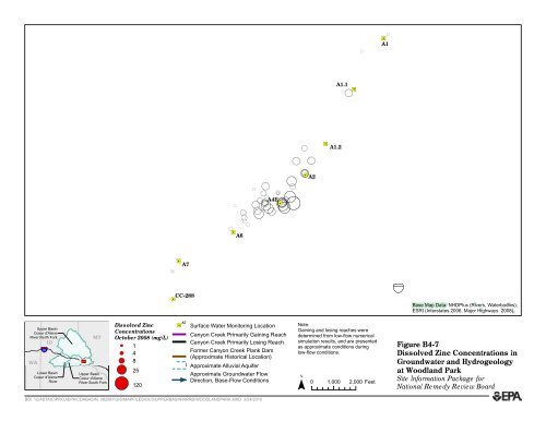
Dissolved Zinc "/ A7<br />
Surface Water Monitoring Location<br />
Concentrations<br />
October 2008 (mg/L)<br />
Canyon Creek Primarily Gaining Reach<br />
Canyon Creek Primarily Losing Reach<br />
! ( 1<br />
! ( 4<br />
! ( 8<br />
( 25<br />
"/ A7<br />
"/ CC-288<br />
Former Canyon Creek Plank Dam<br />
(Approximate Historical Location)<br />
Approximate Alluvial Aquifer<br />
!( ! Approximate Groundwater Flow<br />
Direction, Base-Flow Conditions<br />
120<br />
BOI \\CASTAIC\PROJ\EPA\CDABASIN_382081\GIS\MAPFILES\OU3\UPPERBASIN\NRRB\WOODLANDPARK.MXD 3/24/2010<br />
! (<br />
! ( ! (<br />
! ( ! "/<br />
! (<br />
! (<br />
( !<br />
Note:<br />
Gaining and losing reaches were<br />
determined from low-flow numerical<br />
simulation results, and are presented<br />
as approximate conditions during<br />
low-flow conditions.<br />
¯<br />
A2<br />
"/ A1.2<br />
! ( "/<br />
A1.1<br />
0 1,000 2,000 Feet<br />
( !<br />
"/<br />
A1<br />
§¨ 90 ¦<br />
Base Map Data: NHDPlus (Rivers, Waterbodies);<br />
ESRI (Interstates 2006, Major Highways 2008).<br />
Figure<br />
B4-7<br />
D issolved Zinc Concentrations in<br />
Groundwater and Hydrogeology<br />
at Woodland Park<br />
<strong>Site</strong> <strong>In<strong>for</strong>mation</strong> <strong>Package</strong> <strong>for</strong><br />
<strong>National</strong> <strong>Remedy</strong> <strong>Review</strong> <strong>Board</strong>


