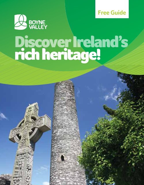
Free Guide - Discover Ireland
Free Guide - Discover Ireland
Free Guide - Discover Ireland

Create successful ePaper yourself
Turn your PDF publications into a flip-book with our unique Google optimized e-Paper software.
<strong>Free</strong> <strong>Guide</strong><br />
<strong>Discover</strong> <strong>Ireland</strong>’s<br />
rich heritage!<br />
FOR MORE INFORMATION GO TO WWW.DISCOVERIRELAND.IE/BOYNEVALLEY 1
<strong>Discover</strong> <strong>Ireland</strong>’s<br />
rich heritage!<br />
Oldcastle<br />
14 13<br />
Athboy<br />
12<br />
KELLS<br />
M3<br />
10 11<br />
TRIM<br />
2 FOR MORE INFORMATION GO TO WWW.DISCOVERIRELAND.IE/BOYNEVALLEY<br />
15<br />
NAVAN<br />
To Belfast (120km from D<br />
Ardee<br />
Slane<br />
7<br />
8<br />
Brú na Bóinne<br />
Newgrange<br />
9<br />
N2 M<br />
M3<br />
N
ogheda)<br />
4<br />
1<br />
6<br />
5<br />
2<br />
Dunleer<br />
2<br />
1 16<br />
3<br />
M1<br />
To Dublin (50km from Drogheda)<br />
M1<br />
Royal Site<br />
Monastery<br />
Megalithic Tomb<br />
Church<br />
Battle Site<br />
Castle<br />
Tower<br />
Period House<br />
DROGHEDA<br />
KEY<br />
01 Millmount Museum<br />
02 St Peter’s Church, Drogheda<br />
03 Beaulieu House<br />
04 Battle of the Boyne<br />
05 Mellifont Abbey<br />
06 Monasterboice<br />
07 Slane Castle<br />
08 Brú na Bóinne (Newgrange)<br />
09 Hill of Tara<br />
10 Trim Castle<br />
11 Trim Heritage Town<br />
12 Kells Heritage Town Round Tower<br />
& High Crosses<br />
13 Loughcrew Gardens<br />
14 Loughcrew Cairns<br />
15 Navan County Town<br />
16 Drogheda Walled Town<br />
Belfast<br />
The Boyne Area<br />
Dublin
2 FOR MORE INFORMATION GO TO WWW.DISCOVERIRELAND.IE/BOYNEVALLEY
<strong>Discover</strong> <strong>Ireland</strong>’s<br />
rich heritage!<br />
Map No.<br />
01<br />
02<br />
03<br />
04<br />
05<br />
06<br />
07<br />
08<br />
09<br />
10<br />
11<br />
12<br />
13 14<br />
15<br />
16<br />
Page No.<br />
Introduction 04<br />
Archaeological & Historical Timeline 06<br />
Millmount Museum & Martello Tower 08<br />
St. Peter’s Church (Shrine of St. Oliver Plunkett) 10<br />
Beaulieu House 12<br />
Battle of the Boyne Site 14<br />
Old Mellifont Abbey 16<br />
Monasterboice Round Tower & High Crosses 18<br />
Slane Castle 22<br />
Brú na Bóinne (Newgrange & Knowth) 24<br />
Hill of Tara 26<br />
Trim Castle 28<br />
Trim (Heritage Town) 30<br />
Kells Round Tower & High Crosses 32<br />
Loughcrew Cairns & Garden 34<br />
Navan (County Town) 36<br />
Drogheda (Walled Town) 38<br />
Myths & Legends 40<br />
Suggested Itinerary 1,2 & 3 46<br />
Your Road map 50<br />
Every care has been taken to ensure accuracy in the completion of this brochure. Fáilte <strong>Ireland</strong> cannot however, accept responsibility<br />
for errors or omissions but where such are brought to our attention, future publications will be amended accordingly. It is<br />
recommended that you pre-check the details of events/attractions listed before travelling.© Copyright Fáilte <strong>Ireland</strong> PRINTED IN<br />
IRELAND<br />
FOR MORE INFORMATION GO TO WWW.DISCOVERIRELAND.IE/BOYNEVALLEY 3
The Boyne Valley<br />
The Boyne Valley is situated in the east<br />
of <strong>Ireland</strong>. It is at once <strong>Ireland</strong>’s ancient<br />
capital and its most sacred and mythical<br />
landscape. In 1849 William Wilde, father<br />
of Oscar, wrote of the Boyne that the<br />
history of <strong>Ireland</strong> may be traced through<br />
its monuments. This remains true today.<br />
Moreover, its sites and monuments are<br />
amongst the best examples of their<br />
kind in Europe and are all within a short<br />
distance of each other. In one day you<br />
can visit the great prehistoric tombs at<br />
Brú na Bóinne (Newgrange) and the site<br />
of the infamous Battle of the Boyne.<br />
You can look out from the Hill of Tara,<br />
sharing the view with the ancient High<br />
Kings of <strong>Ireland</strong>, or be mesmerised by<br />
the detail of the Celtic Crosses at Kells.<br />
4 FOR MORE INFORMATION GO TO WWW.DISCOVERIRELAND.IE/BOYNEVALLEY<br />
You can stand in awe at the gates of<br />
Trim Castle, the largest Anglo-Norman<br />
castle in Europe, or pay your respects at<br />
the shrine of St. Oliver Plunkett.<br />
Boyne: River & Valley<br />
The River Boyne is the principal<br />
waterway in Leinster, the most easterly<br />
of the Irish provinces. The river rises at<br />
Trinity Well, near Cadbury, Co. Kildare<br />
and meanders slowly north-eastwards<br />
through the gentle and fertile plains<br />
of Co. Meath before entering the Irish<br />
Sea at Drogheda, Co. Louth. The valley<br />
through which it flows is a landscape<br />
of large farms, celebrated for their<br />
fine pastures, picturesque villages and<br />
thriving towns. There is a long history
“So memorable in<br />
ancient history,<br />
and so rich in<br />
monuments of the<br />
past is it … that the<br />
history of <strong>Ireland</strong><br />
might be written in<br />
tracing its banks.”<br />
William Wilde,<br />
The Beauties of<br />
the Boyne (1849)<br />
of continuous human settlement along<br />
the banks of the Boyne – stretching<br />
back over five millennia. So why did<br />
prehistoric people settle and thrive<br />
along the banks of this river? The<br />
answer lies in the landscape and climate<br />
of the region.<br />
The richness of the soil in the lands<br />
bordering and drained by the Boyne<br />
was ideal for Neolithic farmers (who<br />
began to arrive in <strong>Ireland</strong> around<br />
4,000 BC). Moreover, the east coast of<br />
<strong>Ireland</strong>, between Dublin and Drogheda,<br />
is the driest part of the country and<br />
ideally suited to growing crops. The<br />
river was valuable as a source of food<br />
and, long before roads, its waters were<br />
vital for travel and trade. The River<br />
Boyne, which derives its name from the<br />
legendary Celtic goddess Bóann (see<br />
Myths & Legends, p. 38), has long been<br />
recognised as one of <strong>Ireland</strong>’s most<br />
important waterways.<br />
In the 2nd century AD the Greek<br />
geographer, Claudius Ptolemy recorded<br />
the outline of the island of <strong>Ireland</strong> in the<br />
form of a set of coordinates showing<br />
different geographical features such<br />
as headlands and rivers. He included<br />
on this map, in his own language, the<br />
names of several Irish tribes, cities and<br />
rivers, including ‘Bouvinda’ – the Boyne.<br />
FOR MORE INFORMATION GO TO WWW.DISCOVERIRELAND.IE/BOYNEVALLEY 5
Boyne Valley<br />
Archaeological & Historical Timeline<br />
Our journey begins 9,000<br />
years ago after the great ice<br />
sheets that covered <strong>Ireland</strong><br />
during the last Ice Age had<br />
retreated. The island was<br />
wild, uninhabited and<br />
heavily wooded. The first<br />
people – Stone Age hunters<br />
– were drawn to Irish shores<br />
in search of food.<br />
Viking Age<br />
790 – 1169 AD<br />
804 AD<br />
Kells monastery founded by<br />
monks from St. Columba’s<br />
foundation, Iona<br />
980 AD<br />
Battle of Tara<br />
1007 AD<br />
Book of Kells stolen<br />
1022 AD<br />
Tara abandoned as<br />
seat of the High Kings<br />
of <strong>Ireland</strong><br />
1142 AD<br />
Mellifont Abbey is<br />
founded by St. Malachy<br />
of Armagh<br />
1152 AD<br />
Synod of Kells<br />
Mesolithic Period<br />
7000 – 4000 BC<br />
c. 7000 BC<br />
First Mesolithic<br />
hunter gatherers<br />
arrive in <strong>Ireland</strong><br />
Medieval Period<br />
1169 – 1550 AD<br />
1169 AD<br />
Anglo-Normans arrive<br />
in <strong>Ireland</strong><br />
1172 AD<br />
Henry II grants Meath to<br />
Hugh de Lacy<br />
1173 AD<br />
Trim Castle built by<br />
Hugh de Lacy<br />
1194 AD<br />
Drogheda-in-Meath<br />
granted charter and<br />
‘officially’ founded<br />
1494 AD<br />
Poyning’s Law passed in<br />
Drogheda<br />
1512 AD<br />
Slane Abbey is<br />
constructed<br />
6 FOR MORE INFORMATION GO TO WWW.DISCOVERIRELAND.IE/BOYNEVALLEY<br />
Neolithic Period<br />
4000 – 2200 BC<br />
c. 4000 BC<br />
First wave of Neolithic<br />
farmers arrive in <strong>Ireland</strong><br />
c. 3200 BC<br />
Newgrange,<br />
Dowth & Knowth<br />
c. 3000 BC<br />
Loughcrew<br />
Post-Medieval Period<br />
1550 – 1800 AD<br />
1641 AD<br />
Rebellion<br />
1649 AD<br />
Cromwell’s Siege of Drogheda<br />
1681 AD<br />
St. Oliver Plunkett martyred<br />
1690 AD<br />
Battle of the Boyne<br />
1699 AD<br />
Newgrange is ‘discovered’<br />
1785 AD<br />
Slane Castle is reconstructed<br />
1798 AD<br />
Rising
Bronze Age<br />
2200 – 600 BC<br />
Industrial Age<br />
1800 – 1900 AD<br />
Iron Age<br />
600 BC – 400 AD<br />
Modern Age<br />
1900 – present<br />
Early Christian Period<br />
400 – 790 AD<br />
Early activity at Tara 227 - 266 AD<br />
433 AD<br />
Legendary King of <strong>Ireland</strong><br />
St. Patrick returns to<br />
Cormac Mac Airt reigns<br />
<strong>Ireland</strong> & lights Paschal<br />
from Tara<br />
fire at Hill of Slane<br />
1808 AD<br />
Millmount Mortello Tower is<br />
constructed<br />
1843 AD<br />
One million people attend<br />
Daniel O’Connell’s ‘monster<br />
meeting’ at Tara<br />
1847 AD<br />
Worst year of the Great<br />
Famine, known as ‘Black ‘47’<br />
1855 AD<br />
Boyne Viaduct railway bridge<br />
completed<br />
1887 AD<br />
Francis Ledwidge, poet, born<br />
outside Slane, Co. Meath<br />
1953 AD<br />
Pierce Brosnan, former<br />
James Bond, & honorary<br />
OBE, is born in Navan<br />
1986 AD<br />
Freddy Mercury & Queen<br />
play Slane Castle<br />
1993 AD<br />
Newgrange, Knowth &<br />
Dowth become UNESCO<br />
World Heritage sites<br />
May 2008<br />
Visitor Centre at the<br />
Battle of the Boyne<br />
site officially opened<br />
by Taoiseach Bertie<br />
Ahern and First<br />
Minister of Northern<br />
<strong>Ireland</strong>, Dr. Ian Paisley<br />
521 AD<br />
St. Buite, founder of<br />
Monasterboice, dies<br />
FOR MORE INFORMATION GO TO WWW.DISCOVERIRELAND.IE/BOYNEVALLEY 7
Millmount Museum<br />
Millmount Museum and Martello Tower<br />
are situated on high ground in the heart<br />
of Drogheda near to where the river Boyne<br />
finally meets the sea<br />
Shortly after the Anglo-Norman King Henry II granted him the<br />
Kingdom of Meath in 1172, Hugh de Lacy constructed a motte<br />
and bailey on a huge mound overlooking the River Boyne. A<br />
more substantial stone fort replaced the earlier structure.<br />
According to Irish mythology, the mound<br />
was the burial place of Amergin mac Míled,<br />
druid, bard and judge of the Milesians.<br />
Amergin was the son of Míl Espáine and<br />
brother of Éremón (see Myths & Legends,<br />
p. 38). The true origin of the mound is<br />
unclear, however, it is thought that it may<br />
be a large passage tomb, similar to those<br />
at nearby Brú na Bóinne.<br />
This castle formed part of the defences<br />
of the town during Cromwell’s siege of<br />
Drogheda in 1649. The garrison were<br />
massacred when they surrendered to<br />
Parliamentarian troops on September<br />
8 FOR MORE INFORMATION GO TO WWW.DISCOVERIRELAND.IE/BOYNEVALLEY<br />
11th, 1649. In the early 1800s the earlier<br />
fortifications were demolished and<br />
replaced by a Martello Tower as part of a<br />
series of defences erected along the Irish<br />
coast by the British in expectation of an<br />
invasion by Napoleon Bonaparte.<br />
Millmount Museum houses various<br />
exhibitions dealing with archaeology,<br />
folklife, local history, geology, industry and<br />
military history. The museum also contains<br />
one of the four surviving examples of an<br />
ancient type of fishing vessel, called a<br />
coracle, that were once a common sight<br />
on the Boyne. Coracles were made of<br />
wicker and covered with animal hide, or
more recently with canvas. It was almost<br />
square but with rounded corners and was<br />
operated by two people – one paddling at<br />
the bow, the other manning the nets.<br />
Did you know … The fort at Millmount was<br />
considerably damaged during the Irish<br />
Civil War (1922-23) when it was occupied<br />
by Anti-Treaty forces and was shelled for<br />
several hours by the Irish <strong>Free</strong> State Army.<br />
It was restored by Drogheda Corporation<br />
and opened to the public in 2000.<br />
Contact Details:<br />
Millmount Museum,<br />
Millmount Complex,<br />
Drogheda, Co. Louth<br />
GPS: 53.711800 - 6.350319<br />
T: + 353 (0) 41 98 33097<br />
F: + 353 (0) 41 98 41599<br />
E: info@millmount.net<br />
W: www.millmount.net<br />
Notes:<br />
Please note last tours<br />
are 60 minutes<br />
before closing.<br />
FOR OPENING TIMES AND ADMISSION DETAILS PLEASE SEE PULL OUT INSERT AT THE BACK 9
St. Peter’s Church is among the finest<br />
Gothic Revival churches in <strong>Ireland</strong> and is<br />
famous for housing the shrine of St. Oliver<br />
Plunkett<br />
St. Peter’s Roman Catholic Church, situated on West St., is one of the<br />
most notable buildings in Drogheda. The first church on this site was<br />
constructed in 1791. The present building was built in the 1880s<br />
and incorporates part of this earlier structure.<br />
10 FOR MORE INFORMATION GO TO WWW.DISCOVERIRELAND.IE/BOYNEVALLEY
The imposing façade of St. Peters is<br />
Gothic Revival in style and is built of local<br />
limestone. The interior of the church is<br />
lavishly decorated. The west transept of<br />
the church contains a special chapel which<br />
houses the preserved head of St. Oliver<br />
Plunkett (1625 – 81), the last Catholic<br />
martyr to die in England.<br />
Oliver Plunkett was born in 1625 at<br />
Loughcrew, near Oldcastle, Co. Meath.<br />
He was sent to be educated by the Jesuits<br />
at the newly established Irish college in<br />
Rome where he was ordained. In 1669<br />
Oliver Plunkett was appointed Archbishop<br />
of Armagh and Primate of All-<strong>Ireland</strong>.<br />
He was arrested in Dublin in 1679 on<br />
trumped up charges of plotting to bring<br />
a French Army into the country and of<br />
organising Irishmen for rebellion. An initial<br />
trial at Dundalk collapsed in 1680. He<br />
was then transferred to England where,<br />
despite several petitions, he was found<br />
guilty of high treason. On the first of<br />
July, 1681, Oliver Plunkett was hanged,<br />
disembowelled, and quartered at Tyburn,<br />
England. His remains were recovered<br />
immediately after the execution and were<br />
eventually entrusted to the Sienna Nuns<br />
of the Dominican Convent at Drogheda.<br />
They are presently on view, enshrined in<br />
St. Peter’s Catholic Church. The church<br />
also contains the door from Plunkett’s<br />
prison cell at Newgate, London. St. Oliver<br />
Plunkett was beatified in 1920, and<br />
canonised in 1975 by Pope Paul VI.<br />
Did you know … When the Roman Catholic<br />
Church canonised St. Oliver Plunkett on<br />
October 12th 1975, he became the first<br />
Irish saint for more than 700 years. St.<br />
Malachy, founder of the Cistercian Abbey<br />
at Mellifont, was canonised in 1199.<br />
Contact Details:<br />
St Peter’s Church,<br />
Drogheda Tourist Office,<br />
Mayoralty St,<br />
Drogheda, Co. Louth<br />
T: + 353 (0) 41 983 8239<br />
F: + 353 (0) 41 984 1351<br />
E: tourism@drogheda.ie<br />
W: www.drogheda.ie<br />
St. Peter’s Church<br />
Notes:<br />
A Mass in honour of St. Oliver Plunkett is held in<br />
St. Peter’s Church on the last Saturday of every<br />
month at 6.15pm.<br />
FOR OPENING TIMES AND ADMISSION DETAILS PLEASE SEE PULL OUT INSERT AT THE BACK 11
Beaulieu House<br />
Beaulieu House is a 17th Century house<br />
and gardens with a collection of classic<br />
racing cars<br />
Beaulieu House is situated on the north bank of the river Boyne<br />
between Drogheda and the Irish Sea. The estate was originally<br />
owned by the ‘St. Oliver’ branch of the Plunkett family and was<br />
acquired about 1650 by Sir Henry Tichbourne, who was Marshall of<br />
the Army in <strong>Ireland</strong> and Governor General of Drogheda at the time<br />
of the Restoration of Charles II.<br />
Beaulieu House was turned into the house<br />
we see today by the Tichbournes in the<br />
mid 17th and early 18th Century and<br />
has remained largely unchanged since.<br />
Originally a stone Plunkett Castle, the<br />
present structure is a mixture of brick and<br />
stone which was rendered in the late 19th<br />
Century, leaving exposed the Dutch brick<br />
surrounds to windows and doors. The<br />
Dutch style is unique in <strong>Ireland</strong>.<br />
The walled garden is believed to have been<br />
designed by Dutch artist Willem Van Der<br />
Hagen, who settled in <strong>Ireland</strong> in the 1720s,<br />
and is one of the earliest examples of a<br />
walled garden in <strong>Ireland</strong>.<br />
12 FOR MORE INFORMATION GO TO WWW.DISCOVERIRELAND.IE/BOYNEVALLEY<br />
Gabriel DeFreitas, the current owner of<br />
Beaulieu House, is a tenth generation<br />
descendant of Henry Tichbourne. There<br />
is a museum on site which displays a<br />
collection of classic racing cars and<br />
memorabilia. <strong>Guide</strong>d tours of the house,<br />
four-acre walled garden and museum<br />
are available.
Did you know … The current owner of<br />
Beaulieu House, Gabriel DeFreitas, had a<br />
very successful career in motor racing in<br />
the 1960s and 1970s under the name of<br />
Gabriel Konig.<br />
Contact Details:<br />
Beaulieu House,<br />
Gardens & Car Museum,<br />
Drogheda, Co Louth<br />
GPS: 53° 43.7N 6° 17.7W<br />
T: + 353 (0) 41 983 8557<br />
F: + 353 (0) 41 984 5051<br />
E: info@beaulieuhouse.ie<br />
W: www.beaulieu.ie<br />
FOR OPENING TIMES AND ADMISSION DETAILS PLEASE SEE PULL OUT INSERT AT THE BACK 13
The Battle of the Boyne is one of the most<br />
significant events in Irish history<br />
The Battle of the Boyne was fought between King William III and<br />
his father-in-law King James II on 1 July 1690. The kings were rival<br />
claimants to the English, Scottish and Irish thrones. Protestant King<br />
William (of Orange) had deposed Catholic King James in 1688.<br />
14 FOR MORE INFORMATION GO TO WWW.DISCOVERIRELAND.IE/BOYNEVALLEY
William’s army (called Williamites),<br />
numbered some 36,000 men and was<br />
made up of English, Irish, Scottish,<br />
Dutch, Danish and Huguenots (French<br />
Protestants). The opposing army (called<br />
Jacobites) were mainly Irish Catholics,<br />
reinforced by 6,500 French troops sent<br />
by King Louis XIV. The Jacobites chose the<br />
River Boyne as the best defence against<br />
the Williamites progress south towards<br />
Dublin. Drogheda was garrisoned and a<br />
force of 25,000 men was positioned at<br />
Oldbridge, the most likely crossing point.<br />
The armies camped on opposite sides of<br />
the river.<br />
William’s battle plan was to trap the<br />
Jacobite army in a pincer movement. He<br />
sent a force of 10,000 men towards Slane<br />
which drew the bulk of the Jacobites<br />
upstream in opposition. With 1,300<br />
Jacobites posted in Drogheda, only 6,000<br />
were left at Oldbridge to repel 26,000<br />
Williamites. All the fighting took place on<br />
the south side of the river as the vastly<br />
outnumbered Jacobite forces defended<br />
their position against the advancing<br />
Williamites. William himself crossed at<br />
Drybridge with 3,500 mounted troops. The<br />
Jacobites retreated across the river Nanny<br />
Battle Of The Boyne Site<br />
at Duleek and regrouped west of the<br />
Shannon to carry on the war.<br />
William’s victory at the Battle of the<br />
Boyne was the turning point in James’<br />
unsuccessful attempt to regain the Crown<br />
and ultimately ensured the continuation<br />
of Protestant supremacy in <strong>Ireland</strong>. Of<br />
the 61,000 men that fought in the battle,<br />
a relatively small number were killed:<br />
1,000 Jacobites and 500 Williamites.<br />
The Battle of the Boyne Visitor Centre<br />
is located in the recently restored 18th<br />
century Oldbridge House, which is on the<br />
battlesite.<br />
Did you know … The Battle of the Boyne<br />
was the largest ever assembly of troops on<br />
an Irish battlefield.<br />
Contact Details:<br />
Battle of the Boyne Visitor Centre, Oldbridge<br />
House, Drogheda, Co. Meath<br />
T: + 353 (0) 41 9809950<br />
F: + 353 (0) 41 9849873<br />
E: battleoftheboyne@opw.ie<br />
W: www.battleoftheboyne.ie<br />
Notes:<br />
Events Calendar including details of<br />
Living History displays is available at<br />
www.battleoftheboyne.ie<br />
FOR OPENING TIMES AND ADMISSION DETAILS PLEASE SEE PULL OUT INSERT AT THE BACK 15
Mellifont Abbey<br />
Mellifont Abbey was one of the wealthiest<br />
and most influential monastic houses in<br />
medieval <strong>Ireland</strong><br />
Mellifont Abbey is situated in a tranquil valley on the banks of the<br />
River Mattock, a tributary of the River Boyne. The Abbey derives<br />
its name from the Latin Font Mellis meaning ‘fountain of honey’.<br />
Many medieval monasteries founded by continental orders bore<br />
Latin names. Mellifont is the only one that survives as a current<br />
placename in <strong>Ireland</strong>.<br />
St. Malachy, Archbishop of Armagh, along<br />
with a community of Irish and French monks<br />
(trained at Clairvaux, Burgundy), founded<br />
Mellifont Abbey in 1142 on lands granted<br />
by Donogh O’Carroll, King of Oriel. It was<br />
the first Cistercian monastery established in<br />
<strong>Ireland</strong> and over 20 other Cistercian houses<br />
were founded directly or indirectly from it.<br />
Mellifont also became one of the wealthiest<br />
abbeys in <strong>Ireland</strong> with vast holdings of land<br />
in the fertile Boyne Valley.<br />
The Abbey was consecrated in 1157 amidst<br />
great ceremony at a national synod, which<br />
was attended by the leading clergy of the<br />
time and Murtaugh MacLochlainn, the<br />
16 FOR MORE INFORMATION GO TO WWW.DISCOVERIRELAND.IE/BOYNEVALLEY<br />
High King of <strong>Ireland</strong>. Mellifont heralded<br />
a new era in Irish monasticism. Prior to<br />
its foundation, older Irish monasteries<br />
(such as Monasterboice) were essentially<br />
independent self-governed spiritual centres,<br />
under the direction of an Abbott who was<br />
largely his own master. These older monastic<br />
sites were often not affiliated to any other<br />
monastery or even to any religious order.<br />
Mellifont was dissolved in 1539 and passed<br />
into the hands of Sir Edward Moore who<br />
converted the abbey buildings into a<br />
residence. In 1603, following Irish defeat<br />
at the Battle of Kinsale, Hugh O’ Neill, the<br />
Earl of Tyrone, formally submitted to Lord
* An Artist Impression, as it might have looked<br />
in its heyday, illustration by Uto Hogerzeil<br />
Mountjoy at Mellifont Abbey signing the<br />
Treaty of Mellifont. This sounded the death<br />
knell for Gaelic civilisation in <strong>Ireland</strong>. During<br />
the Battle of the Boyne in 1690 King William<br />
based his headquarters at Mellifont. The<br />
house was abandoned and fell into disrepair<br />
in the early 1700s.<br />
Although the remains of the Abbey are<br />
fragmentary, Mellifont is historically and<br />
architecturally significant. It was the first<br />
abbey in <strong>Ireland</strong> to be laid out according<br />
to the European cloistral plan – buildings<br />
constructed around a central open space.<br />
Its distinguishing feature is an octagonal<br />
lavabo, constructed about 1200, which<br />
functioned as a place for the monks to<br />
wash their hands in a symbolic gesture as<br />
a preparation for prayer. Lavabo means ‘I<br />
shall wash’. The lavabo, the chapter house<br />
and the late medieval gate house remain<br />
partly intact. The layout of the reminder of<br />
the abbey can be seen from foundations<br />
revealed during excavations.<br />
Did you know … Devorgilla (often described<br />
as ‘<strong>Ireland</strong>’s Helen of Troy’), whose<br />
elopement with Dermot MacMurrough led<br />
to the arrival of the Anglo-Normans in 1169<br />
is buried beneath the chancel pavement at<br />
Mellifont. In 1157 she donated 60 ounces<br />
of gold, along with altar cloths and a gold<br />
chalice to Mellifont. She died there in 1193<br />
at the age of 85.<br />
Contact Details:<br />
Old Mellifont Abbey, Tullyallen,<br />
Drogheda, Co. Louth<br />
T: + 353 (0) 41 982 6459<br />
F: + 353 (0) 41 982 6053<br />
E: mellifontabbey@opw.ie<br />
W: www.heritageireland.ie<br />
FOR OPENING TIMES AND ADMISSION DETAILS PLEASE SEE PULL OUT INSERT AT THE BACK 17
The Cross of Muiredach at Monasterboice<br />
is the finest High Cross in <strong>Ireland</strong> and<br />
is highly regarded as one of the best<br />
surviving examples of Irish religious art<br />
18 FOR MORE INFORMATION GO TO WWW.DISCOVERIRELAND.IE/BOYNEVALLEY
Christianity was introduced into <strong>Ireland</strong>, probably from Roman<br />
Britain, during the 5th century AD, around the time of the collapse<br />
of the Roman Empire. Monasterboice is one of <strong>Ireland</strong>’s earliest and<br />
best-known religious sites. Its name derives from the Irish Mainistir<br />
Bhuithe meaning ‘the monastery of Buite’.<br />
St. Buite, Buite mac Bronaig, was an Irish<br />
monk and follower of St. Patrick. In 480,<br />
according to legend, St. Buite on a return<br />
trip from Rome raised Nechtan Morbet,<br />
the King of Pictland (Scotland), from<br />
the dead. Another legend states that he<br />
ascended into heaven via a golden ladder<br />
lowered from the skies by angels. St. Buite<br />
died on the day St. Columba was born (7th<br />
December, 521).<br />
The site comprises two churches and a<br />
round tower. Although round towers were<br />
originally thought to have been places of<br />
refuge from Vikings, the Irish name for<br />
these towers – cloic theach meaning a bell<br />
house – hints at another possible function.<br />
The tower at Monasterboice was burned<br />
in 1097, destroying the monastic library<br />
and other treasures. However, it is still in<br />
excellent condition, though without its<br />
Monasterboice<br />
conical cap. It is the second tallest round<br />
tower in <strong>Ireland</strong>, after the one on Scattery<br />
Island, Co. Clare.<br />
The Vikings occupied the site for a period<br />
until they were routed by Domhnall, King of<br />
Tara, in 968. St. Buite’s monastery remained<br />
an important centre of spirituality and<br />
learning for many centuries until the<br />
establishment of Mellifont Abbey in 1142.<br />
The site also contains two of the finest<br />
High Crosses in <strong>Ireland</strong> – the South Cross<br />
(or Cross of Muiredach) and the West<br />
Cross (or Tall Cross) – which date from the<br />
9th century. The sandstone crosses are<br />
finely carved and depict biblical scenes<br />
from the Old and New Testaments. Today<br />
the image of the High Cross is recognised<br />
internationally, not merely as a religious<br />
icon but also, as a symbol of Irish cultural<br />
heritage.<br />
FOR OPENING TIMES AND ADMISSION DETAILS PLEASE SEE PULL OUT INSERT AT THE BACK 19
* An Artist Impression, as it might have looked in its heyday, illustration by Uto Hogerzeil<br />
High Crosses<br />
High Crosses, also known as Celtic Crosses,<br />
are distinctive ringed crosses that have<br />
become a symbol of Celtic Christianity.<br />
They are free standing and often of<br />
monumental proportion.<br />
Standing almost 5.5m in height and carved<br />
from a single block of sandstone, the South<br />
Cross at Monasterboice is arguably the<br />
finest and best preserved High Cross in<br />
<strong>Ireland</strong>. It is often referred to as the Cross<br />
of St. Muiredach because of an inscription<br />
at the bottom of the shaft which translates<br />
as ‘a prayer for Muiredach who had this<br />
cross made’. It is thought that this refers to<br />
20 FOR MORE INFORMATION GO TO WWW.DISCOVERIRELAND.IE/BOYNEVALLEY<br />
Muiredach Mac Domhnaill, who was Abbott<br />
of Monasterboice from 890 – 923.<br />
Did you know …<br />
The West Cross, appropriately named<br />
the Tall Cross, is the tallest high cross in<br />
<strong>Ireland</strong>, standing at around 7m. Kirbuddo<br />
(near Forfar, Scotland) also derives its<br />
name from St. Buite and is twinned with<br />
Monasterboice.<br />
Contact Details:<br />
Monasterboice Tour <strong>Guide</strong>s<br />
C/O Drogheda Tourist Office<br />
Drogheda, Co. Louth<br />
T: + 353 (0) 41 987 2843<br />
E: droghedatouristoffice@gmail.com
West Face (top to base)<br />
Ascension of Christ (top of cross)<br />
Peter denying Christ (left arm)<br />
Crucifixion (centre of cross)<br />
Resurrection of Christ (right arm)<br />
Christ flanked by Peter & Paul (upper panel)<br />
Thomas meeting the Risen Christ (middle panel)<br />
Soldiers arresting Christ (lower panel)<br />
Dedication to Muiredach (base)<br />
East Face (Illustration)<br />
Cross of St.<br />
Muiredach<br />
High Cross (known as<br />
the South Cross, or<br />
Cross of Muiredach),<br />
Monasterboice, Co.<br />
Louth<br />
West Face (Illustration)<br />
East Face (top to base)<br />
St Paul & St Anthony (top of cross)<br />
The Saved Souls (left arm)<br />
The Last Judgement (centre of cross)<br />
The Damned Souls (right arm)<br />
Adoration of the Magi (upper panel)<br />
Moses Drawing Water from the Rock<br />
(upper middle panel)<br />
David & Goliath (lower middle panel)<br />
Cain slaying Abel (lower panel, right)<br />
Adam & Eve (lower panel, left)<br />
FOR OPENING TIMES AND ADMISSION DETAILS PLEASE SEE PULL OUT INSERT AT THE BACK 21
Slane Castle<br />
Slane Castle is the residence of<br />
<strong>Ireland</strong>’s most famous aristocrat, Henry<br />
Conyngham, Earl of Mount Charles<br />
Slane Castle is set on the grounds of a 1,500 acre estate through<br />
which flows the River Boyne, a few kilometres upstream from the<br />
site of the Battle of the Boyne.<br />
Following the Williamite War (1689 – 91) a<br />
half a million Irish acres were confiscated<br />
from those who supported James II. The<br />
Conynghams purchased the estate in 1701<br />
following the Williamite Confiscations. Prior<br />
to this the lands were in the posession of<br />
the Flemings, Anglo-Norman Catholics who<br />
supported the Jacobites.<br />
Slane Castle in its existing form was<br />
reconstructed under the direction of William<br />
Burton Conyngham, together with his<br />
nephew the first Marquess Conyngham.<br />
The reconstruction dates from 1785 and<br />
was undertaken by the most distuinguished<br />
architects of the day, most notably James<br />
Gandon who designed The Custom House<br />
and The Four Courts in Dublin and Francis<br />
Johnson who is responsible for the GPO, in<br />
22 FOR MORE INFORMATION GO TO WWW.DISCOVERIRELAND.IE/BOYNEVALLEY<br />
Dublin. The parklands were laid out by the<br />
renowned landscape architect, Capability<br />
Brown known as “England’s greatest<br />
gardener”.<br />
In 1991, a fire in the Castle caused extensive<br />
damage and completely destroyed the<br />
eastern wing facing the River Boyne. It<br />
re-opened to the public in 2001 following a<br />
ten-year restoration programme funded by<br />
the family.<br />
Over the last quarter of a century Slane Castle<br />
has become internationally famous for its<br />
summer concerts. Its natural amphitheatre<br />
attracts 80,000 music fans annually. Queen,<br />
Thin Lizzy, The Rolling Stones, Bob Dylan,<br />
Bruce Springsteen, David Bowie, Guns N’<br />
Roses, Neil Young, REM, Bryan Adams, U2,
Stereophonics, Red Hot Chili Peppers and<br />
Madonna have all performed under the<br />
shadow of the Castle. Oasis headlined the<br />
Slane Castle 2009 concert.<br />
Did you know … U2 recorded part of their<br />
fourth studio album, The Unforgettable<br />
Fire, in Slane Castle; the Drawing Room was<br />
converted into a recording studio. The video<br />
for the song Pride (In the Name of Love) was<br />
shot in the Gothic Revival Ballroom which<br />
was created for George IV’s State Visit<br />
in 1821.<br />
In 2009 Lord Henry and Lord Alex Mount<br />
Charles launched the Slane Castle Irish<br />
Whiskey at the Oasis concert: chosen by<br />
three generations of the Conyngham family,<br />
Slane Castle Irish Whiskey is a smooth,<br />
well balanced blend of malt and grain Irish<br />
Whiskey which has been matured for a<br />
least four years in Bourbon casks made of<br />
American oak. In the traditional Irish Style,<br />
the malt whiskey is distilled in copper pot<br />
stills and no peated malt is used. Both the<br />
malt content and the carefully controlled<br />
maturation give this small batch whiskey its<br />
subtle sweetness and depth of character.<br />
Private Whiskey Tastings hosted by<br />
Conyngham family available upon request.<br />
Contact Details:<br />
Slane Castle, Slane, Co Meath.<br />
GPS: 53° 42’ 31.38”, -6° 33’ 51.72”<br />
T: + 353 (0) 41 982 0643<br />
F: + 353 (0) 41 982 0642<br />
E: info@slanecastle.ie<br />
W: www.slanecastle.ie<br />
FOR OPENING TIMES AND ADMISSION DETAILS PLEASE SEE PULL OUT INSERT AT THE BACK 23
Brú na Bóinne is one of the largest and<br />
most important prehistoric megalithic<br />
sites in Europe<br />
Brú na Bóinne is the name given to an extensive and hugely important<br />
archaeological landscape situated on the north bank of the river<br />
Boyne, 8 kilometres west of Drogheda. The site is dominated by three<br />
large passage tombs – Newgrange, Knowth and Dowth – which were<br />
declared a World Heritage Site by UNESCO in 1993.<br />
24 FOR MORE INFORMATION GO TO WWW.DISCOVERIRELAND.IE/BOYNEVALLEY
Passage tombs consist of a burial chamber<br />
reached by a long straight passage lined<br />
with stones, and set within a large mound<br />
known as a cairn. They are usually sited<br />
on hilltops and grouped in cemeteries.<br />
Although primarily burial sites, they also<br />
served as status symbols, focal points for<br />
the community, places to honour dead<br />
ancestors and as territorial markers.<br />
It is estimated that there are 700 decorated<br />
stones at Brú na Bóinne making it Europe’s<br />
largest and most important concentration<br />
of prehistoric megalithic art. The most<br />
famous of these stones is the one marking<br />
the entrance to Newgrange where the triple<br />
spiral, unique to this site, can be seen.<br />
Constructed during the New Stone Age (or<br />
Neolithic Period, from Greek “neo” meaning<br />
new and “lithos” meaning stone) the tombs<br />
at Brú na Bóinne are around 5,000 years old.<br />
Although the people who built these tombs<br />
were primarily farmers they also possessed<br />
expertise in engineering, geology, art and<br />
even astronomy.<br />
At dawn on the morning of the winter<br />
solstice, and for a number of days before<br />
and after, the main chamber at Newgrange<br />
is illuminated by a beam of sunlight for<br />
17 minutes. This alignment is too precise<br />
to have occurred by chance. It is thought<br />
that Newgrange is the oldest surviving<br />
deliberately aligned structure in the world.<br />
Although Newgrange, Knowth and Dowth<br />
were constructed around 3000 BC activity<br />
Brú Na Bóinne (Newgrange)<br />
at the sites continued for many millennia.<br />
Knowth for example, served as a burial site in<br />
the Iron Age, as the royal seat of the King of<br />
Northern Brega in the Early Christian period,<br />
and as an Anglo-Norman Motte in the Early<br />
Medieval Period.<br />
There is no direct access to Newgrange and<br />
Knowth; all admission is through the Brú<br />
na Bóinne Visitor Centre which is located<br />
near the village of Donore. The excellent<br />
exhibitions at the Visitor Centre include a full<br />
scale replica of the chamber at Newgrange.<br />
Visitors are brought from the centre to the<br />
monuments by shuttle bus.<br />
Did you know … Constructed around 3200<br />
BC, Newgrange is 500 years older than the<br />
pyramids of Egypt and 1,000 years older<br />
than Stonehenge in England.<br />
Contact Details:<br />
Brú na Bóinne (Newgrange & Knowth), Donore,<br />
Drogheda, Co. Meath<br />
GPS: 53° 41’ 40.20”, -6° 26’ 46.68”<br />
T: + 353 (0) 41 988 0300<br />
F: + 353 (0) 41 982 3071<br />
E: brunaboinne@opw.ie<br />
W: www.heritageireland.ie<br />
Notes:<br />
Visitor Centre and Newgrange is open all year round.<br />
(excl. 24-27 December). Knowth is open from Easter<br />
to end of October. Last admission to the visitor centre<br />
is 45 minutes before closing time. Last admission<br />
to visit any of the sites is 2 hours before closing time.<br />
Please note this site can be extremely busy during<br />
the summer months – early arrival for booking of the<br />
tours is recommended. See www.heritageireland.ie<br />
for additional information.<br />
FOR OPENING TIMES AND ADMISSION DETAILS PLEASE SEE PULL OUT INSERT AT THE BACK 25
The Hill Of Tara<br />
The Hill of Tara was the seat of the High<br />
Kings of <strong>Ireland</strong> and the most sacred site<br />
in ancient <strong>Ireland</strong><br />
The Hill of Tara is a low-lying ridge located between Navan and<br />
Dunshaughlin in Co. Meath. It is said that a quarter of the landscape<br />
of <strong>Ireland</strong> can be seen from the hill. Tara gets its name from<br />
Teamhair na Rí meaning ‘sanctuary of the kings’ and it is important<br />
as the traditional inauguration site of the ancient High Kings of<br />
<strong>Ireland</strong>. Although few of its monuments survive the test of time, it<br />
is an evocative place, much celebrated in Irish myth and legend.<br />
Tara was an important site long before<br />
the High Kings. A passage tomb known<br />
as Dumha na nGiall (meaning ‘the mound<br />
of the hostages’) is the oldest visible<br />
monument and dates from around 3,000<br />
BC. However, Tara became truly important<br />
in the Iron Age (600 BC to 400 AD) and<br />
into the Early Christian Period. In 433 St.<br />
Patrick from the nearby Hill of Slane lit the<br />
Paschal fire in defiance of the pagan king<br />
of Tara (see Myths & Legends, p. 41).<br />
Tara was the royal centre of Mide (meaning<br />
‘the middle kingdom’), the fifth province<br />
of ancient <strong>Ireland</strong>. It incorporated the<br />
present Co. Meath and what is now<br />
26 FOR MORE INFORMATION GO TO WWW.DISCOVERIRELAND.IE/BOYNEVALLEY<br />
Westmeath and large parts of Cavan and<br />
Longford. The title ‘King of Tara’ always<br />
implied a special power, however, it was<br />
not until the 9th century AD that the title<br />
became synonymous with High King of<br />
<strong>Ireland</strong>.<br />
One of the most interesting monuments at<br />
Tara is the Lia Fáil (Stone of Destiny), which<br />
is a standing stone located within an area<br />
known as the Forrad (The Royal Seat). This<br />
was the inauguration stone of the Kings<br />
of Tara. According to tradition, when a<br />
true Irish or Scottish King placed his foot<br />
on Lia Fáil it cried out to announce his<br />
rightful reign. Other monuments include<br />
Teach Miodchuarta (The Banqueting Hall),
* An Artist Impression, as it might have looked in its heyday, illustration by Uto Hogerzeil<br />
Rath na Rí (The Fort of the Kings), Teach<br />
Cormaic (Cormac’s House), Rath Gráinne<br />
(The Fort of Gráinne), Rath na Seanadh<br />
(The Rath of the Synods) and Claoin<br />
Fhearta (The Sloping Trenches).<br />
Although Tara was finally abandoned by<br />
Mael Shechlainn, High King of <strong>Ireland</strong>, in<br />
1022 it continued to play an important<br />
symbolic role in Irish history into the<br />
modern period. In 1843 an estimated<br />
one million people gathered there to hear<br />
Daniel ‘The Liberator’ O’Connell speak<br />
against the Union of Great Britain and<br />
<strong>Ireland</strong>. In 1902, in a letter to the Editor of<br />
The Times, Tara was described by Douglas<br />
Hyde, George Moore and William Butler<br />
Yeats, key figures in the Gaelic Revival, as<br />
‘the most consecrated spot in <strong>Ireland</strong>’.<br />
Did you know … A group of British Israelites<br />
nearly destroyed Rath na Seanadh (The<br />
Rath of the Synods) between 1899<br />
and 1902. They believed the Ark of the<br />
Covenant was buried there.<br />
Contact Details:<br />
Hill of Tara, Tara, Navan, Co. Meath<br />
GPS: 53° 34’ 52.68”, -6° 36’ 32.04”<br />
T & F: + 353 (0) 46 902 5903<br />
E: hilloftara@opw.ie<br />
W: www.heritageireland.ie<br />
FOR OPENING TIMES AND ADMISSION DETAILS PLEASE SEE PULL OUT INSERT AT THE BACK 27
Trim Castle is the largest,<br />
best-preserved & most impressive<br />
Anglo-Norman castle in <strong>Ireland</strong><br />
Trim get its name from the Irish Áth Truim, meaning ‘The Ford of the<br />
Elder Trees’, indicating that this was an important fording point on<br />
the River Boyne. Such was the significance of this crossing point that<br />
by the fifth century a chieftain’s dún (fort) and an early monastery<br />
were sited here.<br />
In 1172, shortly after the arrival of the<br />
Anglo-Normans in <strong>Ireland</strong>, King Henry<br />
II granted Hugh de Lacy the Kingdom of<br />
Meath, along with custody of Dublin. The<br />
King feared that Srongbow (Richard de<br />
Clare) might set up a rival Anglo-Norman<br />
kingdom in <strong>Ireland</strong>.<br />
28 FOR MORE INFORMATION GO TO WWW.DISCOVERIRELAND.IE/BOYNEVALLEY<br />
For strategic reasons, de Lacy decided<br />
to make Trim, rather than Drogheda, the<br />
centre of his newly acquired lordship.<br />
De Lacy converted a ringfort into a<br />
wooden castle with a spiked stockade.<br />
This structure was seen as a threat by the<br />
Gaelic Irish and in 1174 Rory O’Connor,
King of Connacht (and last High King of<br />
<strong>Ireland</strong>), attacked and it was destroyed.<br />
The following year work began on a more<br />
permanent stone replacement and over the<br />
following decades Hugh de Lacy (d. 1186)<br />
and his son Walter constructed the largest<br />
Anglo-Norman castle in Europe.<br />
Initially a stone keep, or tower, replaced<br />
the wooden fortification. The keep was<br />
remodeled and then surrounded by curtain<br />
walls and a moat. The wall, punctuated by<br />
several towers and a gatehouse, fortified<br />
an area of about 3 acres. Most of the castle<br />
visible today was completed by 1220.<br />
The unique twenty-sided cruciform<br />
design of the keep (with walls 3m thick) is<br />
an example of the experimental military<br />
architecture of the period. It served as both<br />
the domestic and administrative centre<br />
of the castle. By 1500 much of <strong>Ireland</strong> was<br />
back in the hands of Gaelic Chieftains and<br />
the territory under English control had<br />
been reduced to an area around Dublin,<br />
known as ‘The Pale’. By this time Trim<br />
Castle was in decline, however, it remained<br />
an important outpost protecting the northwestern<br />
frontier of The Pale.<br />
Over the centuries Trim Castle was<br />
adapted to suit the domestic needs of its<br />
owners and the changing political climate.<br />
However, much of its fabric has remained<br />
unchanged since the height of Anglo-<br />
Norman power in <strong>Ireland</strong>. Even today when<br />
standing within the walls of the castle<br />
visitors can get the sense of security that<br />
would have been felt by the de Lacy family<br />
in a hostile landscape. Although, standing<br />
outside the walls you can sense the<br />
intimidation that must surely have been<br />
felt by the native population.<br />
Did you know … Trim Castle served as<br />
a ‘castle double’ for York Castle in Mel<br />
Gibson’s 1996 Oscar-winning movie<br />
Braveheart.<br />
Contact Details:<br />
Trim Castle, Trim, Co. Meath<br />
GPS: 53.5522 - 6.4463<br />
T: + 353 (0) 46 943 8619<br />
F: + 353 (0) 46 943 8618<br />
E: trimcastle@opw.ie<br />
W: www.heritageireland.ie<br />
GPS +53° 33’ 7.92”, -6° 47’ 25.08”<br />
* An Artist Impression, as it might have looked<br />
in its heyday, illustration by Uto Hogerzeil<br />
Trim Castle<br />
FOR OPENING TIMES AND ADMISSION DETAILS PLEASE SEE PULL OUT INSERT AT THE BACK 29
Trim<br />
Trim contains more Medieval buildings<br />
than any town in <strong>Ireland</strong><br />
Trim is situated on the banks of the River Boyne in an area of fertile<br />
plains. The town developed around Trim Castle, straddling the river<br />
to the north and west of the castle. In the 13th century the town was<br />
enclosed within a circuit of stone walls. Augustinian (1202), Franciscan<br />
(1260), and Dominican (1263) friaries were established, indicating<br />
the growing prosperity of the town. In the later medieval period Trim<br />
became an increasingly exposed frontier, standing between the hostile<br />
worlds of the Anglo-Normans and the Gaelic Irish.<br />
Aside from Trim Castle, which dominates<br />
the town, the fragments of the medieval<br />
town are still clearly visible. The wall which<br />
circled the settlement is visible in part, mainly<br />
around Castle St. and Emmet St. west of the<br />
castle. The Sheep Gate is the only surviving of<br />
several medieval gateways to the town. The<br />
jagged Yellow Steeple was formerly a sevenstoried<br />
church tower belonging to St Mary’s<br />
Augustinian Abbey, it gets its name from<br />
the colour of the stonework in the evening<br />
sun. St Patrick’s Church (Church of <strong>Ireland</strong>)<br />
is primarily a 19th century structure, though<br />
with medieval remains.<br />
The tower on its west face incorporates<br />
the arms of Richard, Duke of York, Lord<br />
of Trim and Viceroy in <strong>Ireland</strong> from 1449.<br />
Interestingly, <strong>Ireland</strong>’s oldest complete and<br />
30 FOR MORE INFORMATION GO TO WWW.DISCOVERIRELAND.IE/BOYNEVALLEY<br />
unaltered bridge (dating from 1393) crosses<br />
the Boyne at Trim.<br />
A few kilometres downstream of Trim stand<br />
the ruins of Newtown Trim – a large medieval<br />
cathedral, two monasteries and a small<br />
church. These ruins symbolise the failed<br />
attempt by the first English Bishop of Meath,<br />
Simon de Rochfort, to establish a rival town to<br />
de Lacy’s Trim.<br />
During the early 1700s Jonathan Swift, author<br />
of Gulliver’s Travels, lived at Lacacor, near<br />
Trim, where he served as vicar to a small<br />
congregation. Arthur Wellesey, better known<br />
as the Duke of Wellington or ‘the Iron Duke’,<br />
was educated at Trim and spent much of<br />
his childhood at the nearby Dangan Castle,<br />
his father’s country house (now in ruins). He
is credited with Napoleon’s defeat at the<br />
Battle of Waterloo in 1815, and later served<br />
as Prime Minister of Great Britain (1828-30).<br />
Don Ambrosio O’Higgins (1720 – 1801), the<br />
Spanish Viceroy of Peru and Chile, was born at<br />
Dangan Castle. His son, Bernardo O’Higgins,<br />
went on to become the ‘Liberator of Chile’.<br />
Housed in the Old Town Hall building<br />
Trim Visitor Centre has an audio visual<br />
presentation titled “The Power & the Glory”.<br />
Here visitors can learn more about life in<br />
medieval Trim and County Meath as well as<br />
more about how the coming of the Normans<br />
affected the area. The visitor centre also<br />
has a tourist information point, gift and<br />
coffee shop.<br />
Did you know … There is a small Gaeltacht<br />
(Irish-speaking community) at Ráth Cairn<br />
(Rathcarne), near Trim. In the 1930s a total<br />
of 443 people from Connemara in the west<br />
of <strong>Ireland</strong> were resettled on land acquired<br />
by the Land Commission. It received official<br />
recognition as a Gaeltacht in 1967. Walk<br />
along the River Boyne and see the ruins of<br />
S S Peter & Paul Cathedral and the Hospital<br />
of St John The Baptist. Visitors can call into<br />
the Visitor Centre for a town map and more<br />
details about the walk.<br />
Contact Details:<br />
Trim Visitor Centre and Ramparts Coffee Shop,<br />
Castle St, Trim, Co. Meath<br />
T: + 353 (0) 46 943 7227<br />
F: + 353 (0) 46 943 8053<br />
E: trimvisitorcentre@eircom.net<br />
W: www.meathtourism.ie<br />
FOR OPENING TIMES AND ADMISSION DETAILS PLEASE SEE PULL OUT INSERT AT THE BACK 31
Kells<br />
The heritage town of Kells contains<br />
many fine examples of early Christian<br />
architecture<br />
Kells derives from the Irish Ceanannas Mór, meaning ‘great residence’.<br />
Long before the coming of Christianity, Kells was a royal residence<br />
associated with the legendary Conn Céadchatach (Conn of the Hundred<br />
Battles) and Cormac mac Airt.<br />
In 550 St. Columba, also known as<br />
St. Colmcille, established a religious<br />
settlement at Kells. In 563 he went into<br />
self-imposed exile on the isle of Iona, off<br />
the west coast of Scotland and founded<br />
another settlement. The island was raided<br />
by Viking fleets in 795, 802 and again<br />
in 804 when sixty-eight people were<br />
killed. Shortly after, the community of<br />
St. Columba’s monastery on Iona were<br />
granted lands at Kells as a safe haven<br />
from invaders.<br />
Generally, monastic settlements were<br />
surrounded by a circular boundary wall<br />
called a vallum, which acted as a frontier<br />
between the holy world within and<br />
the secular world outside. They often<br />
contained a church, graveyard, high<br />
crosses, monk’s cells and from the late<br />
10th century round towers also became<br />
a feature.<br />
32 FOR MORE INFORMATION GO TO WWW.DISCOVERIRELAND.IE/BOYNEVALLEY<br />
The first church at Kells was completed by<br />
814 and in 878 the relics of St. Columba<br />
were relocated from Iona, which was<br />
now prospering. However, Kells itself was<br />
raided by the Vikings in 919, 950 and<br />
969, and many times throughout the<br />
11th century, this time by the Irish. The<br />
most famous treasure created by the<br />
community of St. Columba is the Book of<br />
Kells, a highly ornate version of the four<br />
gospels in Latin. It was written around the<br />
year 800, though it remains unclear<br />
whether it was written in whole or part<br />
at Kells.<br />
Although Kells became an important<br />
Anglo-Norman walled settlement, it is<br />
its monastic heritage that best survives.<br />
Kells’ round tower, though roofless, stands<br />
at a height of 25m. In 1076 Murchadh<br />
Mac Flainn, who was fighting for the High<br />
Kingship of <strong>Ireland</strong>, was murdered in the
tower. The tower is surrounded by several<br />
finely carved high crosses, in various states<br />
of preservation. A stone church known as<br />
St. Columba’s House, dating from the 9th<br />
century is possibly the oldest surviving<br />
structure in the town. It is a classic<br />
example of an early Irish church with a<br />
steeply pointed stone roof.<br />
The Kells Courthouse was originally<br />
designed in 1801 by Francis Johnson,<br />
who also designed the GPO on O’Connell<br />
St. Dublin. The Market Cross of Kells,<br />
which dates from the 9th century and<br />
depicts scenes from the Old and New<br />
Testaments, can be seen at the junction<br />
of the Navan / Dublin (N3) road and the<br />
Slane road.<br />
Did you know … The Kells Crosier, dating<br />
from the late 9th or 10th century, is in<br />
the British Museum, London. In 1850<br />
it appeared without explanation in a<br />
solicitor’s office in the English capital.<br />
Contact Details:<br />
Visitor / Heritage Information Centre,<br />
Reception area - Kells Town Council,<br />
Kells Civic Offices, Headfort Place,<br />
Kells, Co. Meath<br />
T: + 353 (0) 46 9240076<br />
F: + 353 (0) 46 9249316 / 46 9249230<br />
E: kellstouristoffice@meathcoco.ie<br />
W: www.meathtourism.ie<br />
FOR MORE INFORMATION GO TO WWW.DISCOVERIRELAND.IE/BOYNEVALLEY 33
Loughcrew, with a concentration of<br />
around 30 passage tombs, is one of the<br />
most important prehistoric cemeteries<br />
in <strong>Ireland</strong><br />
The Loughcrew complex is a megalithic cemetery containing around<br />
30 passage tombs and is situated around the summit of three hills<br />
near the town of Oldcastle, Co. Meath. Nearby are the restored<br />
17th Century Loughcrew Gardens which also holds the key to the<br />
Loughcrew Cairns site.<br />
34 FOR MORE INFORMATION GO TO WWW.DISCOVERIRELAND.IE/BOYNEVALLEY
Loughcrew is roughly contemporary<br />
with Newgrange (3200 BC). Neolithic<br />
communities built large communal tombs,<br />
or megaliths, for their dead. There are four<br />
main types of tombs, each being named<br />
after a particular and defining feature (court<br />
tombs, portal tombs, passage tombs and<br />
wedge tombs). The typical passage tomb is<br />
cruciform in plan with a long central passage<br />
leading to a main chamber, off which there<br />
are three smaller chambers. The dead were<br />
cremated and the remains placed in the<br />
chambers above the ground. The tombs<br />
were then covered in great mounds of earth<br />
and stones called ‘cairns’, though often<br />
these do not survive.<br />
A distinguishing feature of Irish passage<br />
tombs is the presence of rock art – carved<br />
or picked designs on the internal or external<br />
stones of the tomb. The art is abstract in<br />
form with circles, spirals, arcs, lozenges,<br />
triangles, zigzags and flower motifs being<br />
common. Certain symbols seem to have<br />
been favoured at particular tombs or<br />
cemeteries; spirals at Newgrange, concentric<br />
rectangles at Knowth and rayed circles at<br />
Loughcrew.<br />
One of the best-preserved and most<br />
accessible tombs at Loughcrew, known<br />
as Cairn T, appears to be the central tomb<br />
of the whole complex. It faces the rising<br />
sun at the vernal (March) and autumnal<br />
(September) equinoxes which shines through<br />
the passage to illuminate symbols carved<br />
onto the back wall of the chamber. This tomb<br />
is reputed to be the resting place of Ollamh<br />
Fodhla, a legendary king of <strong>Ireland</strong>.<br />
Did you know … Slieve na Callaigh gets<br />
its name from the Irish Sliabh na Callaí,<br />
meaning ‘Hill of the Witch’ or ‘Hag’s Hill’.<br />
Contact Details for Loughcrew Cairns:<br />
OPW, Cortown, Oldcastle, Co Meath<br />
GPS: 53° 44’ 38.40”, -7° 7’ 7.32”<br />
T: + 353 (0) 49 854 1240<br />
E: brunaboinne@opw.ie<br />
W: www.heritageireland.ie<br />
Contact Details for Loughcrew Gardens<br />
& Adventure Course:<br />
Loughcrew, Oldcastle, Co Meath<br />
T: + 353 (0) 49 854 1356<br />
E: info@loughcrew.com<br />
W: www.loughcrew.com<br />
Loughcrew<br />
Loughcrew Gardens are generally open<br />
March to October every year. The site is full<br />
of history, beauty, fantasy, and atmosphere<br />
making the Gardens a magical experience.<br />
The ancient Yew Walk, medieval moote and<br />
St. Oliver Plunkett’s family church create<br />
a spirit of history with a ‘grotesque’ grotto<br />
with tortured pillars guarding a rockery of<br />
fantasy tree fairy sculptures.<br />
With something for all the family, the<br />
hidden story of Alice In Wonderland and a<br />
small playground keep the younger visitors<br />
happy, while the insect walk with giant bugs<br />
and hidden reptiles appeals to the older<br />
children. The canal, ponds, the water mill and<br />
cascades all create a stunning atmosphere.<br />
FOR OPENING TIMES AND ADMISSION DETAILS PLEASE SEE PULL OUT INSERT AT THE BACK 35
Navan<br />
Situated in the heart of the Boyne Valley,<br />
Navan is an ideal base from which to<br />
explore the nearby attractions of Brú ná<br />
Bóinne, the Hill of Tara, and the historic<br />
towns of Kells and Trim<br />
The burgeoning town of Navan lies at the confluence of the rivers<br />
Boyne and Blackwater. It is the county town, or administrative capital,<br />
of Co. Meath. The name Navan has long confused etymologists. It is<br />
thought that it may take its name from the Irish An Uaimh, meaning<br />
‘the cave’ or perhaps from Nuachongbhail, meaning ‘new habitation’.<br />
Navan lies at the confluence of the rivers<br />
Boyne and Blackwater which has long been<br />
a site of strategic importance. A burial site<br />
close to where the two rivers meet has<br />
been identified as Dún Dubchomair, where<br />
a Viking fleet is reputed to have landed.<br />
The Anglo-Normans also recognised the<br />
importance of this location and around<br />
1185 Joselyn de Angulo converted a<br />
nearby glacial mound into a motte and<br />
bailey castle. Legend tells that this mound<br />
was the burial site of Odhbha, the wife of<br />
Éremón, a Milesian invader from Spain<br />
(see Myths & Legends, p. 38). In the later<br />
medieval period Navan was a walled town<br />
and, like Trim, was an outpost of The Pale.<br />
36 FOR MORE INFORMATION GO TO WWW.DISCOVERIRELAND.IE/BOYNEVALLEY<br />
The ruins of Athlumney Castle facing<br />
Navan across the Boyne are located a<br />
short distance from the town. It consists<br />
of two distinct buildings; an original tower<br />
house built in the 15th century and a Tudor<br />
mansion built around 1600. The house was<br />
burned by the Maguire’s in 1649 rather<br />
than allow Oliver Cromwell shelter within<br />
its walls.<br />
Navan is famous for being the birthplace<br />
of Francis Beaufort (1774 - 1857), who<br />
developed the Beaufort Scale of wind<br />
force. In 1805 Commander (later Admiral)<br />
Beaufort published a method of measuring<br />
the wind at sea based on the sails a frigate
Solstice Arts Centre<br />
could safely hoist. The Beaufort Scale,<br />
as it came to be known, was adopted by<br />
the Royal Navy in 1838 when it became<br />
mandatory for all ship’s log entries. The<br />
13-point scale ranges from 0 (calm) to<br />
12 (hurricane); with this scale also came<br />
descriptions of the state of the sea. From<br />
this standard, sailors were able to predict<br />
how ships would react in certain wind<br />
speeds.<br />
Navan is also the childhood home of<br />
Pierce Brosnan, the fifth actor to play the<br />
acclaimed role as James Bond. Comedians<br />
Dylan Moran and Tommy Tiernan,<br />
and television personality Hector Ó<br />
hEochagáin also hail from the town.<br />
Navan, offers a variety of quality<br />
accommodation, restaurants and bars,<br />
and is an ideal base for touring the Boyne<br />
Valley. There are enjoyable walks around<br />
the town, particularly along the Boyne<br />
River and canal at the Ramparts.<br />
Did you know … Navan is the only<br />
palindromic place in the Republic of<br />
<strong>Ireland</strong>, meaning that its name is spelled<br />
the same from left to right, or right to left.<br />
Europe’s longest palindromic placename<br />
is Assamassa, Portugal and the shortest is<br />
Ee, Netherlands (Holland).<br />
Contact Details:<br />
Solstice Arts Centre & Tourist Information Point<br />
Railway St, Navan, Co. Meath<br />
T: + 353 (0) 46 909 2300<br />
E: info@solsticeartscentre.ie<br />
FOR OPENING TIMES AND ADMISSION DETAILS PLEASE SEE PULL OUT INSERT AT THE BACK 37
Drogheda was an important<br />
Anglo-Norman settlement and one<br />
of the largest walled towns in<br />
Medieval <strong>Ireland</strong><br />
Drogheda derives its name from the Irish Droichead Átha<br />
meaning ‘Bridge of the Ford’. It is the largest town in Co.<br />
Louth – <strong>Ireland</strong>’s smallest county – which is named after<br />
Lugh, the great god of the Celts. Although the origins of<br />
the settlement are obscure, the town certainly owes its<br />
development to the coming of the Anglo-Normans.<br />
38 FOR MORE INFORMATION GO TO WWW.DISCOVERIRELAND.IE/BOYNEVALLEY
Drogheda proper began as an Anglo-Norman<br />
port founded by Hugh de Lacy after whom<br />
the de Lacy Bridge in the town is named.<br />
Around 1180 as two settlements on opposite<br />
banks of the Boyne estuary, downstream<br />
from the ford from which it gets it name.<br />
Drogheda was granted its charter in 1194.<br />
The Anglo-Normans made Drogheda one of<br />
their primary strongholds, completing the<br />
town walls in the mid 13th century. The walls<br />
enclosed and fortified an area of 43 hectares,<br />
north and south of the Boyne, making it<br />
one of the largest walled towns in Medieval<br />
<strong>Ireland</strong>. Drogheda-in-Louth was the larger<br />
of the two towns with a walled area of 32<br />
hectares. After years of conflict and rivalry,<br />
the two boroughs were conjoined as a single<br />
town in 1412, and in 1898 the southern<br />
portion of the town was transferred from<br />
Co. Meath to Co. Louth.<br />
St. Laurence’s Gate, which led to the Friary of<br />
St Laurence, is widely regarded as one of the<br />
finest of its kind in Europe. It consists of two<br />
lofty circular towers, connected together by<br />
a wall, in which there is an archway. It was<br />
originally known as the east gate but it was<br />
renamed in the 14th century because the<br />
street led to the Hospital of St. Laurence.<br />
Visitors can appreciate the spectacular<br />
dimensions of the medieval walls south of<br />
the gate at Featherbed Lane. Twice the walls<br />
and gates of Drogheda held strong against<br />
invasion, firstly when Edward Bruce attacked<br />
the town in 1317 and again in 1642 when Sir<br />
Phelim O’Neill attempted to take Drogheda.<br />
In 1494 Parliament met at Drogheda and<br />
enacted the infamous Poynings’ Law,<br />
(introduced by Lord Deputy Edward Poynings)<br />
which subjected the Irish Parliament to<br />
the control of the English king and council.<br />
Poynings’ Law remained in force until 1801<br />
when The Act of Union made it redundant.<br />
In 1649 Cromwell breached the walls and<br />
sacked the town, massacring 3,500 soldiers,<br />
civilians and clergy, and deporting captives<br />
as slaves to Barbados. Drogheda surrendered<br />
to King William after the Battle of the Boyne<br />
in 1690. Millmount Tower & Museum and St.<br />
Peter’s Church, housing the shrine of St Oliver<br />
Plunkett are also within the town.<br />
Did you know … Drogheda, having recently<br />
surpassed its near neighbour Dundalk, is the<br />
largest town in <strong>Ireland</strong> with just over 35,000<br />
inhabitants (2006 Census). The Boyne Viaduct<br />
at Drogheda is <strong>Ireland</strong>’s greatest example of<br />
Victorian industrial architecture. The bridge,<br />
which carries the Dublin-Belfast railway line,<br />
was opened in 1855.<br />
Contact Details:<br />
Drogheda Tourist Office<br />
Drogheda, Co. Louth<br />
T: + 353 (0) 41 983 2843<br />
E: droghedatouristoffice@gmail.com<br />
Drogheda<br />
FOR OPENING TIMES AND ADMISSION DETAILS PLEASE SEE PULL OUT INSERT AT THE BACK 39
Myths & Legends<br />
Myths & Legends<br />
The Boyne Valley is central to many of <strong>Ireland</strong>’s most famous and<br />
fantastic myths …<br />
Boyne: Mythical Origins<br />
The River Boyne derives its name from<br />
the legendary Celtic goddess Bóann (or<br />
Bóand). The story goes that there was<br />
once a magical well – the Well of Wisdom<br />
(Tobar Segais in Irish) – which belonged<br />
to Nechtain, King of Leinster and husband<br />
to the goddess Bóann. Nechtain was<br />
very protective of his magical well and<br />
no one but he and his three cup bearers<br />
were permitted to visit it. One day Bóann<br />
decided to visit the well and see for herself<br />
its wonders. Some say she walked around<br />
the well three times counter sun-wise,<br />
others say she merely peered into its<br />
magical depths. Whatever the case, the<br />
waters of the well rose up – blinding,<br />
mutilating and drowning the goddess –<br />
and then rushed seawards turning into<br />
a river. Though nothing remains of the<br />
mythical well, its waters remain in the<br />
form of the River Boyne, named after the<br />
drowned goddess Bóann.<br />
40 FOR MORE INFORMATION GO TO WWW.DISCOVERIRELAND.IE/BOYNEVALLEY<br />
The Milesians<br />
According to Irish mythology a man by<br />
the name of Míl Espáine is the common<br />
ancestor of all of the Irish. The story goes<br />
that there was a tribe in the north of Spain<br />
known as the Milesians, or the Sons of Mil.<br />
They invaded <strong>Ireland</strong>, dispossessing the<br />
Tuatha Dé Danann, and divided <strong>Ireland</strong><br />
into provinces: Ulster in the north, Munster<br />
in the south, Connacht in the west,<br />
Leinster in the east and, at the centre, Tara.<br />
According to tradition, Éremón mac Míled<br />
was the first Milesian king of all <strong>Ireland</strong>,<br />
and a contemporary of King David (biblical<br />
King of Israel, who ruled c. 1000 BC). He is<br />
the ancestor of the Úi Néill and the rulers<br />
of Leinster, Connacht and Airgiallia.<br />
While in Spain, Éremón (son of Míl Espáine)<br />
married Odhbha, who bore him three sons.<br />
After a time he abandoned her in favour of<br />
another woman (Tea, who would later give<br />
her name to Tara). When Éremón invaded<br />
The Cattle-Raid of Cooley - Illustrations courtesy of www.celticcolor.com
The Salmon of Knowledge - Illustrations courtesy of www.celticcolor.com<br />
<strong>Ireland</strong>, Odhbha followed him but died of<br />
grief soon after arriving on account of her<br />
husband’s rejection. Her three children<br />
raised a mound in which to bury her. It is<br />
thought that Navan may take its name<br />
from the Irish word for cave (An Uaimh)<br />
– the cave within the mound in which<br />
Odhbha’s remains have rested for the past<br />
three thousand years.<br />
The Cattle-Raid of Cooley<br />
The Cattle-Raid of Cooley (in Irish Táin<br />
Bó Cuailgne, pronounced – Tawn Bow<br />
Cool-in-ya), written more than 1,200<br />
years ago, is <strong>Ireland</strong>’s greatest legend<br />
and one of Europe’s oldest epics. In this<br />
saga Queen Maeve of Connacht and her<br />
husband Ailill decide one night to compare<br />
their possessions. After much discussion,<br />
it becomes evident that Ailill owns a great<br />
white bull, Finnbennach, of which Maeve<br />
has no equal. There is only one bull in<br />
<strong>Ireland</strong> of equal to Finnbennach, the great<br />
brown bull of Cooley. Cooley is a peninsula<br />
in modern day Co. Louth. Maeve decides<br />
she must have the Brown Bull and so<br />
begins the story of the Táin. Maeve and<br />
her armies set off from the Royal Palace<br />
at Rathcroghan, Co. Roscommon (passing<br />
near modern-day Kells, Co. Meath) in<br />
pursuit of the Brown Bull. The only thing<br />
that stands in her way is Cúchulainn, the<br />
greatest of all Celtic heroes, who defends<br />
the Brown Bull and the lands of Ulster, as<br />
his fellow warriors lie asleep under a spell.<br />
The Boyne Valley is associated with many<br />
Myths & Legends<br />
of the tales central episodes: Cúchulainn<br />
intercepted Maeve’s army at the village of<br />
Crossakeel, Co. Meath to try to delay their<br />
march to Ulster.<br />
The Salmon of Knowledge<br />
The Salmon of Knowledge (in Irish, An<br />
Bradán Feasa) is a creature from the<br />
Fenian Cycle of Irish Mythology. It features<br />
in the narrative The Boyhood Deeds of<br />
Fionn, which recounts the early adventures<br />
of the legendary Irish hero Fionn mac<br />
Cumhaill.<br />
According to Irish mythology the first thing<br />
to ever come into creation was a hazel<br />
tree, and in its branches was contained all<br />
the knowledge of the universe. This hazel<br />
tree flourished over the Well of Wisdom<br />
(Tobar Segais) within which lived a great<br />
speckled salmon. The story goes that<br />
the salmon ate the hazel nuts which on<br />
occasion fell into the well, thus acquiring<br />
all the wisdom of the universe. It was<br />
foretold that the first person to catch and<br />
eat the salmon would gain this knowledge<br />
and that a man by the name of Fionn<br />
would be the one to do so. Nonetheless,<br />
many tried and failed, until a poet named<br />
Finnegas having spent seven years fishing<br />
the Boyne caught it. He is believed to have<br />
caught the salmon at Féc’s Pool (Linn Féic),<br />
known as the ‘Pool of the Boyne’, near<br />
Slane, Co. Meath.<br />
FOR MORE INFORMATION GO TO WWW.DISCOVERIRELAND.IE/BOYNEVALLEY 43
Myths & Legends<br />
Finnegas instructed his apprentice,<br />
a young boy named Deimne Maol, to<br />
prepare it for him. Deimne burned his<br />
thumb bursting a blister on the cooking<br />
salmon. Instinctively he put his thumb<br />
into his mouth to ease the pain and in<br />
an instant he acquired all its knowledge.<br />
When Deimne brought the cooked meal<br />
to Finnegas, his master saw something<br />
in the boy’s eyes that had not been there<br />
before. When asked by Finnegas, Deimne<br />
denied that he had eaten of the fish. When<br />
pressed, he admitted his accidental taste.<br />
What the old poet hadn’t known was<br />
that Deimne had another name, given<br />
to him by his mother – Fionn, meaning<br />
her fair-haired one. It was this incredible<br />
knowledge and wisdom gained from the<br />
Salmon of Knowledge that allowed Fionn<br />
mac Cumhaill to become the leader of the<br />
Fianna, the famed heroes of Irish myth. He<br />
was killed at Áth Brea or ‘Ford of Brea’ on<br />
the Boyne.<br />
The Coming of Christianity<br />
According to Irish mythology the Fir Bolgs<br />
were one of the races that inhabited<br />
<strong>Ireland</strong> before the Milesians, from whom<br />
the Irish are descended. The Hill of Slane is<br />
said to be a burial mound for their leader,<br />
King Sláine, and it was from him the hill is<br />
named.<br />
However, the Hill of Slane is most closely<br />
associated with St Patrick. According to<br />
tradition, in 433, as the druids prepared<br />
44 FOR MORE INFORMATION GO TO WWW.DISCOVERIRELAND.IE/BOYNEVALLEY<br />
to celebrate the Feast of Tara, St. Patrick<br />
celebrating Easter lit the Paschal Fire in<br />
direct defiance of the pagan ritual. The<br />
fire was observed from the Hill of Tara<br />
and the druids told King Laoghaire that<br />
unless it was extinguished that same<br />
night, it would never be put out. The king<br />
was outraged, but every time he and his<br />
druids challenged St. Patrick with their<br />
magic they were defeated. Eventually,<br />
and reluctantly, the king and his followers<br />
converted to Christianity. St. Erc, who was<br />
the only person to pay due homage to St.<br />
Patrick during the stand-off, founded a<br />
monastery on the Hill of Slane.<br />
The Cattle-Raid of Cooley - Illustrations courtesy of www.celticcolor.com
Getting to the Boyne Valley is very direct<br />
– the M1 from Dublin Airport will take you<br />
to the heart of it in 30 minutes and from<br />
Belfast City in just over one hour – once<br />
you arrive you can take things at your<br />
own pace, by exploring the back roads of<br />
this historic valley – discover for yourself<br />
its quaint villages & cosy pubs and mingle<br />
with the locals who can share their stories<br />
with you…<br />
46 FOR MORE INFORMATION GO TO WWW.DISCOVERIRELAND.IE/BOYNEVALLEY
Suggested Itinerary 1<br />
M Morning L Lunch A Afternoon D Dinner<br />
Distance Covered in Kilometres: 44 km<br />
M After a hearty Irish breakfast at your<br />
chosen accommodation, explore the<br />
streets of Drogheda (p. 38), with a guided<br />
tour of this historic walled town. You will<br />
discover the impact that historical<br />
figures such as Oliver Cromwell and St.<br />
Oliver Plunkett had on this town and<br />
visit many sites of interest. Hear<br />
too some little-known facts from your<br />
knowledgeable tour guide. For instance,<br />
did you know that a horse named<br />
“Drogheda” won the famous Aintree<br />
Grand National in 1898! A visit to the St.<br />
Peter’s Church (p.10) in Drogheda should<br />
be an essential aspect of your visit to the<br />
town. Indeed it may well be included if<br />
you take a <strong>Guide</strong>d Tour. Complete your<br />
tour with a visit to Millmount Museum<br />
& Martello Tower (p. 8) and enjoy<br />
spectacular views of the town and the<br />
River Boyne estuary.<br />
L Enjoy a leisurely lunch at one of the<br />
many cafes and restaurants in Drogheda<br />
before moving on to your next destination<br />
on this itinerary.<br />
A Leave Drogheda and travel north<br />
about 6 kilometres to visit Monasterboice<br />
Round Tower and Muredach’s High Cross<br />
(p.18). Just a short distance away visit<br />
Mellifont Abbey (p.16). In May 2008, a<br />
new interpretive centre opened at the site<br />
of the seminal Battle of the Boyne (p.14).<br />
Here you can learn about this famous<br />
battle in the history of <strong>Ireland</strong> and Europe.<br />
Take a stroll along the banks of the River<br />
Boyne and you may even catch a glimpse<br />
of the famous Salmon of Knowledge!! (p.<br />
42). On your return to Drogheda a visit to<br />
17th Century Beaulieu House and Gardens<br />
(p.12) on the north bank of the River Boyne<br />
is highly recommended.<br />
D After your busy day why not relax<br />
with dinner at a restaurant in Drogheda<br />
or in the surrounding area. If you still have<br />
some energy left there is sure to be a<br />
traditional Irish music session going on in<br />
Drogheda – a perfect end to your day in<br />
the Boyne Valley!!<br />
FOR MORE INFORMATION GO TO WWW.DISCOVERIRELAND.IE/BOYNEVALLEY 47
Suggested Itinerary 2<br />
M Morning L Lunch A Afternoon D Dinner<br />
Distance Covered in Kilometres: 51 km<br />
M Starting off in the picturesque village<br />
of Slane visit the famous Hill of Slane and<br />
walk in the footsteps of St. Patrick himself,<br />
<strong>Ireland</strong>’s patron saint, where he challenged<br />
the Pagan King of <strong>Ireland</strong> by lighting a<br />
fire to signal the arrival of Christianity in<br />
<strong>Ireland</strong>. Then follow in another famous<br />
Irish man’s footsteps, Bono and U2, and<br />
visit Slane Castle (p. 22), home to so<br />
many world famous rock concerts, for a<br />
guided tour. Continue on to the Brú na<br />
Bóinne Interpretive Centre (p. 24) and<br />
visit the UNESCO World Heritage Site at<br />
Newgrange. This will be an experience that<br />
you will remember long after your visit to<br />
the Boyne Valley is over. On route to Navan<br />
stop off at the Francis Ledwidge Museum<br />
for visit.<br />
48 FOR MORE INFORMATION GO TO WWW.DISCOVERIRELAND.IE/BOYNEVALLEY<br />
L Set off from Slane to Navan town<br />
(p. 36), the County town of Meath. Spend<br />
a while strolling along the banks of the<br />
Boyne at the Ramparts in Navan and enjoy<br />
information on the local flora and fauna<br />
displayed along the walk. Check out the<br />
Solstice Arts Centre in the centre of<br />
the town for details of what’s on during<br />
your stay.<br />
A After lunch set out for the Hill of Tara<br />
(p. 26) seat of the ancient High Kings of<br />
<strong>Ireland</strong>. Travelling onwards stay in Trim for<br />
the night. Explore this medieval town and<br />
the banks of the Boyne by following the<br />
signposted walking routes.<br />
D For Dinner check out some of the<br />
restaurants in the town. If you are up to it<br />
there is sure to be some live traditional<br />
music available in the Slane or Navan areas<br />
and who knows you might even end up<br />
joining in and singing too!!
Suggested Itinerary 3<br />
M Morning L Lunch A Afternoon D Dinner<br />
Distance Covered in Kilometres: 95 km<br />
M No visit to Trim would be complete<br />
without visiting the imposing Trim<br />
Castle. Learn about the history of this<br />
magnificent Anglo-Norman castle and<br />
enjoy the views from the top which look<br />
out over this fertile countryside. Close to<br />
the Castle entrance the Trim Visitor Centre<br />
should be your next visit before leaving<br />
Trim. Find out more about Dunsany Castle<br />
and many other local attractions.<br />
Set off mid morning to the heritage town<br />
of Kells (p. 32) where part of the famous<br />
Book of Kells was written. Do take time to<br />
visit the round tower, Celtic crosses, St.<br />
Columb’s house and the Hill of Lloyd.<br />
L For lunch do visit one of the<br />
restaurants or cafes in Kells.<br />
A In the afternoon take a leisurely drive<br />
from Kells along the Athboy road and stop<br />
off at Causey Farm (check opening hours)<br />
south of Kells. This is a working farm and<br />
children will be especially interested.<br />
Continue on to the Hill of Ward, where the<br />
great Celtic festival of Halloween was first<br />
celebrated. You can then continue on your<br />
journey to the Loughcrew Cairns (p. 34)<br />
near Oldcastle. While in the Loughcrew<br />
area do make sure to visit the Loughcrew<br />
Gardens & Adventure Course (p. 34)<br />
D<br />
Choose from restaurants in Kells for<br />
Dinner.<br />
FOR MORE INFORMATION GO TO WWW.DISCOVERIRELAND.IE/BOYNEVALLEY 49
Your Road Map<br />
See detailed touring route map inserted at the back of this brochure<br />
Take your car and explore the Boyne<br />
Valley in your own time and space.<br />
There is a driving route that will take you all<br />
around the Valley. This route brings you to<br />
the main towns and villages and to the sites<br />
all mentioned in this brochure. Also there<br />
are many sites of historic interest along the<br />
way where you can stop and explore in your<br />
own time. These are as follows (towns are<br />
in bold text) :<br />
– Bru na Boinne Visitor Centre<br />
(Newgrange Monument)<br />
– Duleek Church & Crosses<br />
– Battle of the Boyne Site<br />
– Drogheda<br />
– Millmount Museum &<br />
Martello Tower<br />
– Beaulieu House & Gardens<br />
– Monasterboice Round<br />
Tower & High Crosses<br />
– Old Mellifont Abbey<br />
– Townley Hall<br />
– Dowth<br />
– Ledwidge Museum<br />
– Slane<br />
– Hill of Slane<br />
– Slane Castle<br />
– Donaghmore<br />
– Navan<br />
– Donaghpatrick<br />
– Kells<br />
– Kells Round Tower<br />
– Tower of Lloyd<br />
– Patrickstown<br />
– Oldcastle<br />
– Loughcrew Cairns<br />
– Loughcrew<br />
– Athboy<br />
– Trim<br />
– Trim Castle<br />
– Bective Abbey<br />
– Hill of Tara<br />
– Ardmulchan Church<br />
Oldcastle<br />
R154<br />
Loughcrew<br />
Cairns<br />
Patrickstown<br />
Viewing Point<br />
13<br />
Loughcrew<br />
House &<br />
Gardens<br />
50 FOR MORE INFORMATION GO TO WWW.DISCOVERIRELAND.IE/BOYNEVALLEY<br />
Delvin<br />
N3<br />
Ballinlough<br />
Kilskeer<br />
N51<br />
R163<br />
N52<br />
R154<br />
Athboy<br />
Kells<br />
Round Tow<br />
& High<br />
Crosses<br />
Tower<br />
of Lloyd<br />
Ke
er<br />
lls<br />
N3<br />
Trim Castle<br />
Trim<br />
N51<br />
Donaghpatrick<br />
Church<br />
Donaghpatrick<br />
Navan<br />
N3<br />
Bective<br />
Killmessan<br />
N2<br />
N52 M2<br />
R163 N51<br />
Tara<br />
Dunsany<br />
Slane<br />
M3<br />
Collon<br />
N3<br />
N33<br />
M2<br />
Donore<br />
Drogheda<br />
M3 M1<br />
Duleek<br />
Bective Abbey<br />
Donaghmore<br />
Round Tower<br />
Ardee<br />
Ardmulchan<br />
Church<br />
Hill of Tara<br />
Hill of Slane<br />
Slane Castle<br />
Old Mellifont<br />
Abbey<br />
Francis<br />
Ledwidge<br />
Museum<br />
Townley Hall<br />
Brú na Boinne<br />
Newgrange,<br />
Knowth & Dowth<br />
Killeen Castle<br />
Home of the<br />
Solheim Cup 2011<br />
M1<br />
Monasterboice<br />
Tullyallen<br />
R132<br />
Duleek Church<br />
& Crosses<br />
Millmount<br />
Museum<br />
and Martello<br />
Tower<br />
Battle of<br />
the Boyne<br />
Beaulieu<br />
House<br />
St. Peter’s<br />
Church<br />
FOR MORE INFORMATION GO TO WWW.DISCOVERIRELAND.IE/BOYNEVALLEY 51<br />
D
Notes<br />
For further information please contact:<br />
Bru na Boinne Tourist Office<br />
Visitor Centre<br />
Donore<br />
Co. Meath<br />
T: + 353 (0)41 9880305<br />
+ 353 (0)44 9348761<br />
E: brunaboinne@failteireland.ie<br />
W: www.discoverireland.ie/boynevalley<br />
FI/11223-11