Esrum Å-stien Grøn Mobilitet 2024 - ENGELSK

Create successful ePaper yourself
Turn your PDF publications into a flip-book with our unique Google optimized e-Paper software.
SCAN FOR<br />
MORE INFO<br />
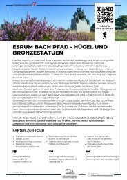
ESRUM STREAM PATH - HEATHER-<br />
CLAD HILLS AND BRONZE STATUES<br />
The tour starts at Dronningmølle Station, where you turn right and follow Dronningmølle<br />
Stationsvej down to road 237, Villingebæk Strandvej. Here, turn right – but consider turning left<br />
to visit Drømmehuset and Drømmecafeen before resuming the route and walking along the<br />
water to Strandkrogen and the campsite. Turn right onto Strandkrogen and right again onto<br />
the path that leads under the railway. Look for the wooden sign to Tegner's Museum.<br />
Follow the narrow gravel path up through the heather-clad landscape. At the museum, there<br />
is a permanent exhibition of sculptor Rudolph Tegner's works as well as changing current<br />
exhibitions. Behind the museum, you will find Sørens Cafe.<br />
After your visit, head through the parking lot to Museumsvej, which leads you to the village of<br />
Villingerød on Villingerødvej. Here, on the right, you will find the farm shop Birkely. However,<br />
you should cross the road and continue on the path. You are now on the <strong>Esrum</strong> Stream Path,<br />
which is signposted to Gilleleje Golf Club.<br />
Along the way, you will find information boards with QR codes so you can learn more about<br />
the <strong>Esrum</strong> Stream Valley, Gilleleje Golf Club, and their restaurant Bistro Nord. There is also a<br />
cozy picnic area along the way. The tour ends at the clubhouse. You can either choose to<br />
return to Dronningmølle or walk along Sophienlund Allé, Søgårdsvej, and Firhøjvej and take<br />
the train from Firhøj Station.<br />
Note: This route will change as the restored landscape at Søborg Lake takes shape.<br />
Currently, the tour ends in Ferle. It will eventually extend to Dragstrup and further down to<br />
Søborg Lake.<br />
FACTS ABOUT THE TOUR<br />
Start: Dronningmølle station<br />
Length: 5,3 km<br />
Surface: Road and gravel<br />
Suitable: Children, adults & dogs<br />
Signage: <strong>Esrum</strong> <strong>Å</strong>-<strong>stien</strong> some of<br />
the way<br />
Toilet: Dronningmølle beach<br />
cafés and museum<br />
Season: All year, the museum<br />
is open April-October<br />
Find interactive map<br />
through QR-code above<br />
Drømmecaféen (1)<br />
Sørens Café (2)<br />
Gilleleje Golfklub (3)<br />
Dronningmølle strand (4)<br />
Rudolph Tegners Museum (5)<br />
Søborg Lake (6)<br />
Dronningmølle Strand Camping (7)<br />
Dronningmølle Kameludlejning (8)<br />
Map on page 2
ESRUM STREAM PATH<br />
8<br />
Hornbæk Bugt<br />
4<br />
Dro tra<br />
nningmølleS n dvej<br />
Firhøj st.<br />
Dronningmølle st.<br />
1<br />
7<br />
Dronningmølle<br />
Villingebæk<br />
Sophienl<br />
u<br />
nd Alle<br />
R U S L A N D<br />
2<br />
5<br />
6<br />
Ferle<br />
3<br />
Museumsvej<br />
Villingerødvej<br />
Ferlevej<br />
Dragstrup<br />
00,5 km1 km<br />
Snævret Skov<br />
1,5 km<br />
2 km<br />
Villingerød<br />
© OpenStreetMap - © Styrelsen for Dataforsyning og Infrastruktur<br />
Dansk Cykelturisme – Visit Nordsjælland