Create successful ePaper yourself
Turn your PDF publications into a flip-book with our unique Google optimized e-Paper software.
MAY <strong>2024</strong> 19<br />
PADDLING continued from 17<br />
of them had my water bottle in his hand,<br />
saving me the trouble of doubling back.<br />
While we were eating lunch, a pontoon<br />
boat arrived at the launch – I presumed<br />
that it had come over from one of the private<br />
camps on the north side of the peninsula<br />
that juts out from this large pond’s<br />
west side. About 290 campsites stretch out<br />
along the east shore.<br />
There was a west wind, so Dave and I<br />
decided to paddle closer to the west shore,<br />
while Bob opted to head to the north end<br />
of the pond in a more direct line. We<br />
reconnected near a culvert that carries the<br />
outlet of Rock Pond under the old railroad<br />
bed – now the <strong>Adirondack</strong> Rail Trail – and<br />
into Rollins Pond. Our goal was to paddle<br />
up to Rock Pond. I had done it twice before<br />
but in <strong>May</strong> when water levels are usually<br />
higher due to snow melt and spring showers.<br />
The best landing spot is north of the<br />
culvert. You can then carry over the rail<br />
trail and pick up a short path on the other<br />
side that leads to the brook. I am not sure<br />
if rail trail construction in <strong>2024</strong> will affect<br />
this brief crossing.<br />
Paddling upstream, we were soon feeling<br />
somewhat discouraged while pushing<br />
through dense patches of pickerelweed<br />
– now past its prime and no longer displaying<br />
those attractive purple flowers<br />
often seen in August – and hitting some<br />
tree debris hidden below the surface of<br />
the water. Perhaps this was not going to<br />
be the best idea on this day! We pushed on<br />
regardless. After going 0.2 miles, the water<br />
was a bit deeper and there was hope. I had<br />
to get out and pull over two small beaver<br />
dams (this is considered normal when<br />
paddling <strong>Adirondack</strong> streams) and I slid<br />
over a few others. The shores were mainly<br />
marshy. Then there was a crude footbridge<br />
across the brook which required a<br />
very short carry. From there it was relatively<br />
easy getting to the pond.<br />
We did a circuit of Rock Pond where<br />
there was a view of Floodwood Mountain<br />
to the west (two of us hiked it on the following<br />
day). A loon hung out on the water<br />
and I discovered its empty nest. There were<br />
cranberries to be found too – September<br />
is the right month for that. It was quite a<br />
bit faster paddling the 1.25 miles back to<br />
Rollins and I was able to slide over all beaver<br />
dams in that direction.<br />
The narrow rocky outlet of Rollins Pond<br />
leaves its north end and tests your paddle<br />
maneuvering skills for about 0.1 miles<br />
before flowing into the southwest corner<br />
of Floodwood Pond. There is a carry trail<br />
on the left – I have paddled through here<br />
several times and have never needed<br />
to carry but I have read reports of<br />
others who did. You can then follow<br />
the pond’s west shore back to the<br />
put-in to complete the loop. Our<br />
trip distance for the day was 12.5<br />
miles and it took us over seven<br />
hours – a satisfying day of paddling!<br />
The loop minus the Rock<br />
Pond side-trip would amount<br />
to a trip length of about nine<br />
miles including 0.4 miles of<br />
carries.<br />
A lover of wild places, Rich<br />
Macha has led many trips for<br />
the <strong>Adirondack</strong> Mountain<br />
Club, and has spent 20 years in the<br />
paddle/snowsport business. More<br />
of Rich’s adventures can be found at<br />
northeastwild.blogspot.com.<br />
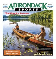
PHOTOS BY RICH MACHA<br />
▲ DAVE AND BOB TACKLE<br />
THE OUTLET OF ROCK POND.<br />
◀ DAVE AND BOB ARRIVE<br />
AT FLOODWOOD POND.<br />
▲ ROLLINS POND.