O-Ringen Magazine, nr 1 2024
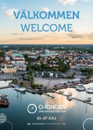
The worlds biggest orienteering adventure. Oskarshamn, Smålandskusten, July 21st to 27 th 2024.
The worlds biggest orienteering adventure. Oskarshamn, Smålandskusten, July 21st to 27 th 2024.

Create successful ePaper yourself
Turn your PDF publications into a flip-book with our unique Google optimized e-Paper software.
REGISTRATION GUIDE O-RINGEN SMÅLANSKUSTEN <strong>2024</strong> <br />
Hitta till din lokala Aximaanläggning!<br />
Din leverantör inom lantbruk, skog, entreprenad, park- och grönyta<br />
REGISTRATION GUIDE<br />
BETTER<br />
PRICE<br />
REGISTER UP AND UNTIL<br />
APRIL 7 TH<br />
Din kompass<br />
genom hela<br />
köpet!<br />
Photo: Peter Holgersson.<br />
LEVELS OF DIFFICULTY - MAIN-, SHORT-, RECREATIONAL- AND OPEN CLASSES<br />
Level<br />
Beginner<br />
Very easy<br />
Easy<br />
Moderate<br />
Moderate<br />
Moderate<br />
Difficult<br />
Difficult<br />
Description<br />
The course is in terrain with clear and connected features such as roads, larger paths, buildings and open land. The controls on a<br />
green course must always be placed on handrails and must provide reassurance that the competitor is following the correct route.<br />
Control features may be path bends, path junctions, telegraph posts, buildings or other clear features or objects.<br />
The terrain is the same as for green courses, i.e. clear and connected features, e.g. roads, larger paths, open land and buildings.<br />
The controls on a white course must mark only the end of one leg and the start of the next. The control features must therefore<br />
be easily identified and distinct. As well as green course features, controls on white courses may also be on e.g. boulders, crags,<br />
fences and similar features.<br />
Yellow courses can be in more difficult terrain but runnability and visibility must still be good. The terrain must have a connected<br />
network of roads, paths, fences, waterways, open areas etc. Control points may be on more difficult features, for example on the<br />
top of a very distinct hill, but must always have a clear attack point. There must be a clear catching feature behind controls.<br />
Orange and red courses must use runnable terrain, with gentler hills and forest, preferably with areas of cultivated land. Terrain<br />
details must be clear. Compared to green, white and yellow courses, more difficult control features may be used, for example larger<br />
re-entrants, distinct ridges, hills and crags. There must be a clear feature a maximum of 200 m before the control and a clear<br />
catching feature behind it.<br />
Same as for orange courses but you can encounter all types of terrain.<br />
All types of terrain may be used. Very physically tough terrain should be avoided. All types of control feature may be used. Compared<br />
to orange and red courses, purple courses place higher demands on, planning skills, choosing quick routes ahead of safe<br />
routes and finding controls without clear catching features behind them.<br />
On blue and black courses, the difficulty should always suit skilled orienteers, even if anyone can compete. The increased difficulty<br />
level compared to other courses is because more of the orienteering uses contour features, detailed terrain and smaller features.<br />
Same as for blue courses but you can encounter all types of terrain.<br />
Facebook · Instagram · YouTube @aximaab | www.axima.se<br />
O-RINGEN MAGAZINE NO. 1 • <strong>2024</strong> 83