брошюра (3)

Create successful ePaper yourself
Turn your PDF publications into a flip-book with our unique Google optimized e-Paper software.
UZBEKISTAN<br />
Harmony with Nature<br />
Responsibility for the Future<br />
eco.gov.uz
Ecotourism<br />
Uzbekistan is not only famous for<br />
the architectural monuments<br />
included in the UNESCO Cultural<br />
Heritage List, not only for the<br />
ancient cities, but also for the<br />
amazing ora and fauna,<br />
picturesque mountains, caves,<br />
deserts and crystal-clear lakes,<br />
rivers and waterfalls.<br />
What do travel companies most often offer when organizing<br />
ecotours? For example, it can be desert safari tours, trips to glaciers,<br />
tours to unique mountain zones, trips to nature reserves and national<br />
parks.<br />
The tourism opportunities of our country are very diverse and rich:<br />
these are Ugam-Chatkal National Park, and the tugai forests in the<br />
Amu Darya River Delta, the Kitab Nature Reserve, recently opened for<br />
tourists, testifying to the appearance of life on our planet, the region of<br />
the “ecological catastrophe” near the Aral Sea, steppe areas and the<br />
Kyzylkum desert, Nurata mountains and Aydarkul Lake, and many<br />
other wonders bof our nature.
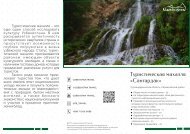
Sangardak<br />
Waterfall<br />
Sangardak Waterfall is located on the territory of Sariosiyo district,<br />
30 km away from the city of Denau and 205 km from the city of Termez.<br />
Sariosiyo district is famous for its subtropical intracontinental climate,<br />
which creates its own unique microclimate in this area. The adyrs and<br />
hills located everywhere are covered with bright greenery in these<br />
places. The Hissar ridge stretches through the territory of the district,<br />
mountain rivers ow from it: Surkhandarya, Tupalandarya, Obizarang<br />
and other watercourses.<br />
Here, in the most picturesque places, you can see a wide variety of<br />
ora and fauna. The mountainous area is inhabited by gazelles,<br />
wolves, foxes, hares, snow leopards and even brown bears; juniper,<br />
pistachio, almonds, walnuts, apple trees, and barberry are common in<br />
the wild rosehip and other plants. In a hollow between two mountain<br />
ranges there is a village of miners "Khandiza", whose inhabitants were<br />
engaged in coal mining. Only 30 km away from it there is a beautiful
waterfall. There are quite a few legends and tales about this natural<br />
attraction among the locals. As rumor has it, ancient Greeks, Arabs,<br />
and rulers from all over Transoxiana came here to admire this waterfall.<br />
The sound of the waterfall is already heard from afar, when you just<br />
pass through the Sangardak gorge. And when you reach it, you see all<br />
the greatness and beauty of the nature of these places. This waterfall<br />
has an amazing feature. It is believed that it is not formed from a<br />
mountain river, but comes from caves, from karst rivers. Flowing water<br />
falls from a 20-meter height in a beautiful cascade over rocks and<br />
aquatic plants.<br />
Waterfalls have always been a place of attraction, they were<br />
considered a miracle of nature, as a gift from above to mere mortals,<br />
so there is a ziyoratgoh near Sangardak – a shrine with its own legend.<br />
Sangardak Waterfall still attracts thousands of people to enjoy the<br />
beauty of the powerful stream and the indescribable charm of the<br />
entire Sariosiyo district.
Valley of Demons -<br />
wonders of nature<br />
In the Samarkand region, just 30 km from the city, there is one<br />
mysterious valley - "Shaitan Zhiga" or "Devil's Helmet". This is a very<br />
magical place. There are huge boulders, granite blocks of bizarre<br />
shapes.
Strange stones are scattered around the valley, have fantastic<br />
shapes that resemble either the faces of demons, or the features of<br />
pagan deities, or the gures of wild animals. In the dark stones, you can<br />
really see a tiger, a huge frog, a bear and even a bird of prey.<br />
Stone blocks are rather sculptures, looking at which it is hard to<br />
believe that nature herself tried to create them. Everyone can<br />
interpret some sculptures in their own way, in them you can see a giant<br />
with a severed head, gigantic heads of giants pressing against each<br />
other, a giant skull of a head, melted castles, frozen labyrinths, petried<br />
warriors and much more.<br />
Many tourists notice an unpleasant atmosphere in this place, the<br />
boulders seem quite inhospitable and frightening. There are no trees<br />
and shrubs here, locals prefer to bypass the plateau side. In the spring,<br />
springs break out from under the stones, and shepherds bring livestock<br />
here to fast.<br />
No one knows exactly where this name came from. According to<br />
local legend, in pagan times, sacricial rites were held here, as well as<br />
during the meeting of Light and Darkness, earthly heroes fought their<br />
battles, tearing rocks and mountains out of the ground, and throwing<br />
them at each other. So the mountains were destroyed, and their<br />
fragments took such incredible shapes.
Chimgan<br />
and Gulkam<br />
Narrows<br />
The Chimgan Mountains are a<br />
fantastic place where nature<br />
proves its strength and perfection.<br />
There is nothing useless and<br />
disordered in these places,<br />
everything is in its place: majestic<br />
c a n y o n s , s t e e p c l i f f s , s w i f t<br />
mountain rivers making their way<br />
through harsh rocks.<br />
Chimgan has become one of the main natural attractions of<br />
Uzbekistan, it is famous for its rich vegetation, birch and walnut groves,<br />
extreme passes, waterfalls and lakes, narrow gorges. The most<br />
beautiful place of Chimgan is the cascades of ridges on Gulkam.<br />
There, thanks to numerous channels and sayas, the Gulkamsai River<br />
was formed, and it, in turn, formed an amazing relief – gorges.<br />
Everyone can see the Gulkam gorge, but it's worth remembering that<br />
mountains are mountains, and such a hike should be accompanied<br />
by an experienced instructor who knows a lot about safety.
Cave drawings<br />
and "stones of<br />
purication" in natural<br />
landmark of Kuruksai<br />
There are many unique places on our planet that have combined<br />
the unimaginable beauty of nature and traces of primitive people. The<br />
Kuruksai tract is a truly mysterious place. A remote corner of our planet,<br />
as if hiding from prying eyes, is located in the Kashkadarya region, near<br />
the village of Dzhizmonsoy.<br />
In addition, to the indescribable beauty of mountains, green<br />
vegetation and unusual shapes of stones, here you can nd eagles<br />
soaring high in the sky, sources, and also rocks with ancient stone age<br />
drawings. The images on the Siypantosh rock (as the locals called it)<br />
show hunting scenes of ancient people, wild horses, wolves, kulans,<br />
foxes, camels and even handprints. There are drawings from a later<br />
period that clearly show how ancient people hunted with bows and<br />
tamed dogs.
Where to go to forget about everything<br />
- to the Arnasai lakes<br />
There are so many amazing places in Uzbekistan where untouched<br />
nature has been preserved, almost in its original form. Few people<br />
know about such wonderful places and few people have been there.<br />
One of these regions is the Aidar-Arnasai drainless lake system.<br />
Aydar-Arnasay lakes are located on the territory of the Jizzakh and<br />
Navoi regions of Uzbekistan and are included in the List of Ramsar<br />
Convention wetlands. Looking at the incredibly breathtaking views of<br />
these places, it is hard to believe that it is actually located in the middle<br />
of the desert, on the Arnasai lowland: between the Hungry Steppe and<br />
the Kyzylkum desert. The Aydar-Arnasay system includes lakes<br />
Aydarkul, Tuzkan and East Arnasay lakes. The total area of the lakes is<br />
four thousand square kilometers.<br />
The East Arnasay lakes are located southwest of the Chardarya<br />
reservoir in the Jizzakh region. Until the 50s of the last century, there<br />
were no East Arnasay lakes, there was a dried-up salt lake, which only<br />
appeared in the lowlands in spring and disappeared again with the<br />
onset of hot weather.
Amir Temur's Cave:<br />
in search of the Unknown<br />
Speleology lovers and adventurers know that caves are the most<br />
mysterious. Therefore, researchers are always faced with a difcult<br />
task, feasible only for daredevils. This is what happens with the study of<br />
the Cave of Amir Timur. They say that treasures are hidden at the very<br />
depth of such a cave.<br />
Going to the cave is not a sight for the faint of heart and not for the<br />
claustrophobic. After all, to conquer it, you will have to go deeper and<br />
further into the bowels, and in some places you will even need to<br />
crawl. However, this does not stop most people, because already at<br />
the very entrance to the cave, inexplicable magnetism and attraction<br />
will be waiting for you. It is difcult to explain what attracts such a cave,<br />
either a thirst for curiosity, or the strongest energy of Amir Timur himself.<br />
According to legend, it was here that the novice commander,<br />
having gathered his army, decided to make a stop for the winter to<br />
gather his strength and go to conquer Kesh (Shakhrisabz), and then<br />
Samarkand. In fact, it was from this cave that Amir Timur's career<br />
began.
Gathering not only his strength, but also his thoughts, the young<br />
Tamerlane already knew exactly what he wanted and how to achieve<br />
it. Indeed, the cave is literally imbued with such a spirit. It does not take<br />
away strength, as it often happens in the mountains, but on the<br />
contrary, it adds incredible courage and self-condence.<br />
The cave of Amir Timur is located in the Kashkadarya region, in the<br />
tract "Kalla-i-Shiron", which means "Lion Fortress". Getting to the cave is<br />
a difcult quest: numerous obstacles will be waiting for you at every<br />
step. This is a vertical two-hundred-meter gorge, which can only be<br />
descended by a narrow path, and an unceasing powerful stream of a<br />
mountain river.
Ecocenter<br />
Jeyran<br />
The unique reserve was established in 1977 and has the status of a<br />
protected natural area. To date, the area of the reserve is 16.5<br />
thousand hectares, the animals are kept in semi-enclosures.<br />
Today, the ecocenter has all the conditions for keeping animals. The<br />
creation of the center allowed to increase the number of not only<br />
goitered gazelles, but also many other rare mammals, birds, sh,<br />
insects and reptiles. In the nursery you can see long-spined<br />
hedgehogs, kulans, Przhevalsky horses, Bukhara mountain sheep,<br />
markhor goats, pink pelicans, herons, swans, eagles, falcons, gray<br />
monitor lizards and many other animals of the desert zone of<br />
Uzbekistan.<br />
There are lakes on the territory of the reserve, which are replenished<br />
by the Amu-Bukhara canal, so the animals have drinking water. To<br />
date, the territory of the Ecocenter is rapidly ennobled. Soon<br />
additional tourist routes will be opened here, which will provide an<br />
opportunity to observe rare animals. Watching Przhevalsky's horses, a<br />
subspecies of a wild horse that lives in Central Asia, will bring special<br />
pleasure. Such horses are very rare and there are only about two<br />
thousand individuals left in the world.
Aydarkul –<br />
a pristine beauty oasis<br />
A worthy place in the list of water tourism routes is occupied by the<br />
drainless lake Aydarkul, located in the endless desert of Kyzylkum.<br />
Because of the beautiful color of the water and its impressive size, the<br />
picturesque lake is often called the "turquoise sea in the sand". No<br />
more than two thousand people live on the banks of Aydarkul, so the<br />
nature around the lake remains wild and untouched.<br />
The shores of the lake extend from Nurata district of Navoi region to<br />
Farish and Mirzachul districts of Jizzakh region.<br />
There are no undercurrents on the lake and the salt content in the<br />
water is not high enough, which has a benecial effect on the<br />
development of ora and fauna in the area. There is a huge number of<br />
sh such as walleye, carp, asp, chukhon, bream, which is favorable for<br />
the development of the shing season and a successful catch.<br />
Over the surface of the lake, you can often see soaring pink pelicans,<br />
graceful swans, and white herons. Here also found shelter birds listed in<br />
the Red book - curly pelican, small cormorant, red-throated kazarka,<br />
piskulka, white-eyed dipper, steppe harrier, white-tailed eagle, black<br />
vulture.
In addition to the wide variety of ora and fauna of the lake,<br />
Aydarkul is considered one of the best places to relax. Many kilometers<br />
of beaches with surprisingly soft and clean sand, pristine cleanliness of<br />
coastal thickets, as well as the peace and quiet of the coastal zone will<br />
leave a lot of positive impressions and unforgettable sensations.<br />
Fans of active recreation and local history are happy to take part in<br />
ethnographic excursions to yurt camps on the banks of Aydarkul.
Sentob<br />
Sentob ecotourism route and recreation area is located in Nurata<br />
district of the Navoi region. Here you can walk through the foothills, as<br />
well as visit the Aydarkul lake.<br />
On the territory of the area three guest houses are located. Their<br />
owners receive guests with great cordiality.
Baysuntau<br />
On the south-western spur of the<br />
Gissar range, in the Surkhandarya<br />
region, there is the world-famous<br />
Baysuntau range, which attracts<br />
adventurers with its huge caves,<br />
d e e p c a n y o n s a n d A l p i n e<br />
meadows. By the way, the huge<br />
fossilized dinosaur tracks were<br />
found here and the notorious<br />
Teshik-Tash cave, where the burial of a Neanderthal girl was<br />
discovered in the last century, is located there. After crossing the hot<br />
steppes of Baysuntau, you nd yourself in the fantastic, magical<br />
settlements, the names of which are so full of magic: Karun, Derbend,<br />
Padang, Rabat. Walnut groves are replaced by juniper forests, alpine<br />
meadows delight the eye with their bright green, spreading like a<br />
carpet on the slopes. The crystal water of the rivers breathes life into all<br />
living things around. The locals cultivate the land in the old way –<br />
drawn by horses and plows. Here the houses are decorated with<br />
handmade carpets, bright suzanas, and local clothes and shoes with a<br />
variety of embroidered ornaments. Almost all houses have a tandoor –<br />
an oven, where bread is baked. Everything in this region is done<br />
manually. Blacksmiths masters of Surkhandarya are famed for their<br />
skills.
Konigil village<br />
and Meros<br />
paper Mill<br />
Sometimes, all we need for happiness is to look at familiar things in a<br />
new way. Just 13 km from Samarkand there is one special place – the<br />
tourist village of Konigil.<br />
The place is famous for its unique traditions of handicrafts, the purest<br />
nature, shady trees, and the Siab River owing nearby. But, perhaps,<br />
the main attraction of this corner is the Meros factory, where paper<br />
production is carried out.<br />
The paper mill was founded by the brothers artisans Mukhtarov.<br />
Thanks to them, the factory revived and established the production of<br />
paper in an ancient way – a technology used long before the advent<br />
of paper machines. The main feature of this technology is manual<br />
labor, which uses exclusively natural raw materials. For this reason, the<br />
paper turns out to be slightly yellowish in color, because it is not<br />
bleached by chemical means. The strength of the paper differs<br />
signicantly from modern bleached paper. Compare: an ordinary<br />
sheet can be stored for 40 years, and Samarkand paper is ten times<br />
longer – 400 years.<br />
In the near future, the village of Konigil is planned to be expanded.<br />
There will be new tourist routes, guest houses and craft centers.
Aral Sea coast<br />
It is difcult to believe that once there was a real sea in place of a hot<br />
and arid desert, and which was the fourth largest in the world. Large<br />
shing boats sailed on it, its waves beat against the coastal rocks, and<br />
hundreds of tourists came to its beaches to swim and sunbathe.<br />
On the one hand is Karakum, on the other hand – Kyzylkum, and<br />
between them is the Aral Sea, or we should say its bottom. Now this<br />
place is called Aralkum or a new desert, and it occupies 54 thousand<br />
square meters. Dozens of ships are moored here forever, slowly turning<br />
into a rusting cemetery. Passing from the ship to the longboat, you<br />
realize that each ship had its own history, its own captain. Now it is the<br />
ships cemetery, resembling a dystopian landscape.<br />
All this can be seen in the city of Muynak, on the southern shore of the<br />
Aral Sea. Half a century ago, this place was the largest port in<br />
Uzbekistan. Here shing vessels came, the largest sh plant worked,<br />
and numerous beaches with places to relax were very popular.
Muynak was surrounded by water and could be reached by plane<br />
or ship. The Aral Sea has moved almost 200 km away, leaving a lifeless<br />
desert. The sea began to dry up in 1970, and by 1980, its level had fallen<br />
so much that it was divided into two parts: the Great and Small Aral.<br />
NASA satellite images clearly show the drying process of the Aral Sea.<br />
By 2014, only 10% of the sea remained, and the salinity of the water<br />
increased from 14 to 100 grams per 1 liter. This has led to the disastrous<br />
consequences. The climate of the Aral Sea region has changed from<br />
moderate to sharply continental.<br />
The bottom of the Aral Sea is mysterious; some scientists compare it<br />
with Atlantis. In addition to the ancient settlements on the sea oor, the<br />
geometric gures were also discovered, which many people have<br />
taken for the message of an extraterrestrial civilization or ancient<br />
writing. They are located on a huge area – almost 20 square meters,<br />
and represent parallel lines that create certain drawings and symbols.<br />
You can see mysterious drawings, poisonous salt marshes and what is<br />
left of the Aral Sea by the helicopter. To do this, you will have to y to the<br />
West in the direction of the Big Aral Sea. Below you can see endless<br />
Martian landscapes, thousands of hectares of white salt sediments<br />
where no life is possible. From time to time, you may come across rows<br />
of saxaul, which show that this is the work of a man. Surprisingly, with<br />
great difculty, the Uzbek people, trying to prevent the Aral disaster,<br />
plant saxaul in the typical desert, creating green oasis.
Zaamin<br />
National Park<br />
One of the national pride of<br />
Uzbekistan, the country's main<br />
health resort, recently named<br />
“Uzbek Switzerland”, is Zaamin<br />
National Park. This area is famous<br />
for its unique nature and healing<br />
air.<br />
The national park with an area of 24.1 hectares is located to the north<br />
of the Turkestan Range in the Zaamin district of Jizzakh region.<br />
Zaamin National Park is opened for the visitors all the year round. The<br />
sanatorium Zaamin is located not far from the park. There are many<br />
boarding houses, sanatoriums, rest homes and children's camps in the<br />
recreation area, which have become a favorite vacation spot for all<br />
Uzbeks for the several decades.
Deserts of<br />
Uzbekistan<br />
The deserts of Uzbekistan are sultry and boundless, incandescent<br />
and under the scorching sun. They occupy more than half of the<br />
country's territory and are considered harsh living conditions in Central<br />
Asia. Deserts stretch from the north-west of the republic and gradually<br />
shrink to the east. In some areas there are picturesque valleys and<br />
oases. Historical cities appeared in such places, which became<br />
important strategic objects.<br />
1. Kyzylkum.<br />
Sandy and rocky desert with ridges of red dunes. The desert is<br />
located in the interuve of the Amudarya and Syrdarya and occupies<br />
a large area on the territory of Uzbekistan. In the northwest, the desert<br />
abuts the Aral Sea, and in the northeast it reaches the spurs of the Tien<br />
Shan. The area of the desert is about three hundred thousand square<br />
meters.
It is noteworthy that despite the harsh desert climate, life is actively<br />
boiling in Kyzylkums. In some places there are lakes, reservoirs and<br />
even tugai thickets. Clay takyrs are replaced by salt marshes, and<br />
sandy massifs by forests of black and white saxaul. Mammals live in the<br />
desert: gazelles, steppe cats, ground squirrels, jerboa, foxes, wolves,<br />
hares, bats. Of the birds, you can meet bustards, eagles, larks, owls.<br />
Snakes, lizards and other reptiles are permanent residents of the<br />
desert.<br />
There are many attractions in the desert for a "wild" or nomadic<br />
holiday. For example, in the Navoi region, you can stay in recreation<br />
areas and live in yurts, ride camels and try camel milk.
2. Aral Kum.<br />
Unfortunately, nature can be<br />
very cruel, so a new desert has<br />
appeared on the seabed of the<br />
once huge Aral Sea. The sandysaline<br />
desert is located on the<br />
t e r r i t o r y o f U z b e k i s t a n a n d<br />
Kazakhstan, has a characteristic<br />
white color due to the large<br />
amount of salt. The area of Aralkum<br />
continues to increase and today it reaches 38 thousand square<br />
meters. The ora and fauna of the desert are poorly represented, and<br />
dust storms carry out about one hundred million tons of dust and toxic<br />
salts per year.<br />
3. Ustyurt plateau.<br />
A mysterious and unusual place on the territory of Uzbekistan occupies<br />
the western part of the country between the Aral Sea and the Amu<br />
Darya Delta. Once there was a world ocean on these lands, leaving<br />
them, there was a lifeless territory - a plateau without water and<br />
greenery. The total area of Ustyurt is almost 200 thousand square<br />
meters and is a clay and clay-gravelly desert. Sometimes on the<br />
plateau there are mountain ranges, high cliffs with steep cliffs,<br />
limestone rocks and white cracks in the ground.
4. Hungry steppe.<br />
It is located on the territory of the Syrdarya region on the left bank of<br />
the Syrdarya, at the outlet of the river from the Fergana Valley. The<br />
total area of the Hungry Steppe is 10 thousand square meters. Initially,<br />
the steppe was a vast plain space with places suitable only for<br />
nomadic life. In the south, the steppe is bounded by the spurs of the<br />
Turkestan Ridge, in the north by the Kyzylkum desert.<br />
Since the end of the XIX century, the development of the Hungry<br />
Steppe took place, the construction of irrigation canals was started.<br />
Gradually, the steppe began to change and become suitable for<br />
economic needs. Thanks to engineers and scientists, the barren<br />
steppe turned into irrigated land and cotton, melons and other crops<br />
began to be grown here. Today, in the Syrdarya region, you can taste<br />
delicious varieties of melons, watermelons, pomegranates grown on<br />
the territory of the once Hungry steppe.
Konimeh Ecopark<br />
Konimeh Ecopark - ecotourism and camping center in Navoi region<br />
At the entrance to the park, next to the parking lot, there is a cozy<br />
restaurant where you can taste Uzbek, Kazakh and Karakalpak<br />
national cuisine. You can also taste fresh camel milk – shubat , a<br />
traditional Kazakh drink, walk around the park, visit yurts, 12 of which<br />
are designed for 12 people at the same time and 1 – for 25 people.
Chatkal<br />
Biosphere Reserve<br />
Chatkal Biosphere Reserve is located in the south of Ugam-Chatkal<br />
National Park. The total area of the reserve is 45 thousand hectares. It is<br />
divided into two sections – Boshkizilsoy and Maidontol. The rst one<br />
stretches on the southern slopes of Chatkal at an altitude of 1000 to<br />
3247 m, and the second one – on the northern slopes and glaciers at<br />
an altitude of 1200 - 3800 m.<br />
The picturesque landscapes of the reserve are represented by<br />
mountain ranges, decorated with juniper forests, alpine and<br />
xerophytic meadows and windy steppe zones.<br />
Chatkal nature reserve is dotted with mountain patterns, caves and<br />
noisy waterfalls. And in the southern part of Maidontol, on the rocks<br />
near the coast of the Tereksai in the Karasau tract, you can observe<br />
ancient cave paintings – the Tereksai petroglyphs. In addition, very<br />
interesting ornithological tours are held in Chatkal reserve.
Kitab State<br />
Geological Reserve<br />
Kitab Nature Reserve is located in Kitab region on the spurs of the<br />
Zarafshan range. This is one of the most unique natural monuments.<br />
Here, you can touch the history of the ancient world, track the stages<br />
of life formation on our planet. The remains of ancient life forms can be<br />
seen in the cuts of the local rocks.<br />
Kitab Nature Reserve is located in Kitab region on the spurs of the<br />
Zarafshan range. This is one of the most unique natural monuments.<br />
Here, you can touch the history of the ancient world, track the stages<br />
of life formation on our planet. The remains of ancient life forms can be<br />
seen in the cuts of the local rocks.
Agalyk mountains and<br />
Devsharshara waterfall<br />
The mountains have always<br />
attracted people with their<br />
delightful appearance, expanse<br />
and immensity. Just 15 km from<br />
Samarkand are located the<br />
picturesque beauty of the Agalyk<br />
Mountains. These mountains, in<br />
tandem with the village of the<br />
same name and the Agalyksay<br />
river, create a unique view of the mountain landscape.<br />
The average height of the mountain is 400 meters, and the highest<br />
peak of the Agalyk Mountains is Mount Kemkutan, its height is 2178<br />
meters. On the territory of the mountain range, you can meet unusual<br />
forms of stone inuxes, numerous channels and tributaries, blooming<br />
poppy elds and the Devsharshara waterfall.<br />
The location of this waterfall is interesting. It seems to be hidden from<br />
prying eyes, but it is betrayed only by the sound of falling water. The<br />
waterfall is located in a small gorge of the mountain, its height reaches<br />
8 meters. Rocks and intricate shapes allow water to ow intensively into<br />
the natural pool.
Stone forest<br />
Stone forest In the Uchkuduk district of Navoi region, 30 km from the<br />
village of Migbulak, there is a unique paleontological open-air<br />
museum.<br />
The stone forest in the Jarakuduk territory is a unique natural<br />
phenomenon. According to scientic assumptions, a real stone forest<br />
grew here more than 96 million years ago as a result of the evolution of<br />
nature based on the centuries-old plane trees.<br />
Stone Forest is a unique and indelible page of the distant past, which<br />
did not go unnoticed even after several million years. According to an<br />
ancient legend, many eras ago, a meteorite fell on this area. As a<br />
result, the sea has gone, and the local land remains in the depths<br />
under the scorching sun and surrounded by boulders. As a result of<br />
physical and chemical phenomena, the remains of the local animals<br />
and plants were dried out and turned into stones.