Africa Surveyors Jan-Feb digital issue 2021
Africa Surveyors is Africa’s premier source of Surveying, Mapping and Geospatial news and an envoy of surveying products/service for the Construction, Maritime, Onshore & Offshore energy and exploration, Engineering, Oil and Gas, Agricultural and Mining sectors on new solution based trends and technology for the African market.
Africa Surveyors is Africa’s premier source of Surveying, Mapping and Geospatial news and an envoy of surveying products/service for the Construction, Maritime, Onshore & Offshore energy and exploration, Engineering, Oil and Gas, Agricultural and Mining sectors on new solution based trends and technology for the African market.

You also want an ePaper? Increase the reach of your titles
YUMPU automatically turns print PDFs into web optimized ePapers that Google loves.
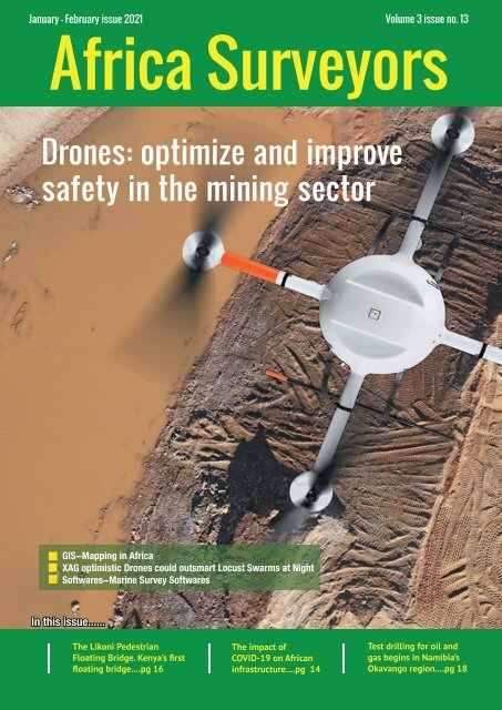
<strong>Jan</strong>uary - <strong>Feb</strong>ruary <strong>issue</strong> <strong>2021</strong> Volume 3 <strong>issue</strong> no. 13<br />
<strong>Africa</strong> <strong>Surveyors</strong><br />
Drones: optimize and improve<br />
safety in the mining sector<br />
GIS-Mapping in <strong>Africa</strong><br />
XAG optimistic Drones could outsmart Locust Swarms at Night<br />
Softwares-Marine Survey Softwares<br />
In this <strong>issue</strong>......<br />
The Likoni Pedestrian<br />
Floating Bridge. Kenya's first<br />
floating bridge....pg 16<br />
www.africasurveyorsonline.com<br />
The impact of<br />
COVID-19 on <strong>Africa</strong>n<br />
infrastructure....pg 14<br />
Test drilling for oil and<br />
gas begins in namibia’s<br />
Okavango region....pg 18<br />
<strong>Jan</strong>uary-<strong>Feb</strong>ruary <strong>issue</strong> l <strong>2021</strong> 1
w<br />
2 <strong>Jan</strong>uary-<strong>Feb</strong>ruary <strong>issue</strong> l <strong>2021</strong> www.africasurveyorsonline.com
Current Issue<br />
How Drones can optimize<br />
and improve safety in the<br />
mining sector & many more<br />
Contents<br />
26<br />
coNteNtS<br />
16<br />
REGULARS<br />
News Briefs 4<br />
Events 8<br />
Innovation 10<br />
Opinion 14<br />
Project review 36<br />
Managing Editor<br />
Francis David<br />
Editor-in-Chief<br />
Augustine Rang’ondi<br />
32<br />
COVER STORY<br />
Drones: How Drones can optimize and improve safety in<br />
the mining sector<br />
14<br />
Editor<br />
Dorcas Kang’ereha<br />
Writer<br />
Violet Ambale<br />
Harriet Mkhaye<br />
Irene Joseph<br />
Innocent Momanyi<br />
Sales Executives<br />
East <strong>Africa</strong><br />
Jimmy Mudasia<br />
Lydia Kamonya<br />
Caiser Momanyi<br />
Vincent Murono<br />
Sheila Ing’ayitsa<br />
South <strong>Africa</strong><br />
Paul Nyakeri<br />
Sean Masangwanyi<br />
Lisa Brown<br />
Thembisa Ndlovu<br />
Nigeria<br />
Emelda Njomboro<br />
Uche Maxwel<br />
Published by:<br />
Nailex <strong>Africa</strong> Publishing<br />
Nairobi, Kenya.<br />
Features<br />
GIS: Mapping in <strong>Africa</strong><br />
Softwares: Marine Survey Softwares<br />
Agricultural: XAG optimistic Drones could outsmart<br />
Locust Swarms at Night<br />
Engineering: Chubb launches Civil Engineering<br />
Completed Risks insurance in South <strong>Africa</strong><br />
Project: New headquarters for Capitec Bank, South<br />
<strong>Africa</strong><br />
The Likoni Pedestrian Floating Bridge. Kenya's first floating<br />
bridge<br />
ADVERTISER'S INDEX<br />
C.R.Kennedy Survey Solutions............................................IFC<br />
Bauder.......................................................................................IBC<br />
Position Partners....................................................................OBC<br />
Geoconnect Asia...................................................................pg 9<br />
MacArtney...............................................................................pg 13<br />
Evologics..................................................................................pg 23<br />
Stannah.....................................................................................pg 24<br />
Caroni........................................................................................pg 25<br />
Saab...........................................................................................pg 28<br />
Mirtk..........................................................................................pg 31<br />
20<br />
35<br />
The Editor accepts letter and manuscripts for publication from readers all over the world. Include your name and address as a sign of good faith although you may request your name to<br />
be withheld from publication. We can reserve the right to edit any material submitted. Send your letters to: info@africasurveyorsonline.com<br />
Disclaimer:<br />
Nailex <strong>Africa</strong> Publishing makes every effort to ensure the accuracy of the contents of its publications, but no warranty is made to such accuracy and no responsibility<br />
will be borne by the publisher for the consequences of actions based on information so published. Further, opinions expressed on interviews are not necessarily shared<br />
by Nailex <strong>Africa</strong> Publisher.<br />
www.africasurveyorsonline.com<br />
<strong>Jan</strong>uary-<strong>Feb</strong>ruary <strong>issue</strong> l <strong>2021</strong> 3
NewS BrIeFS<br />
Fugro multiple offshore geotechnical surveys in Angola<br />
Fugro has been awarded multiple contracts<br />
by Eni Angola to carry out geotechnical and<br />
environmental surveys off the coast of Angola<br />
between now and May. Multipurpose survey vessel<br />
the Fugro Scout, specifically designed for seabed<br />
sampling and in situ testing in water depths up to<br />
3000 m, has embarked on a deepwater environmental<br />
survey to acquire, analyse and interpret sediment<br />
and water samples from Eni Angola’s Agogo field<br />
development. During the survey operations, specialist<br />
marine fauna observers (MFOs) will carefully<br />
monitor the marine mammals, turtles and seabirds.<br />
The study will gather key environmental baseline<br />
data on offshore Angola’s benthic communities,<br />
physicochemical sediment characteristics, and water<br />
Esri Joins Digital Twin Consortium<br />
The global leader in location intelligence,<br />
Esri, today announced it has joined the<br />
Digital Twin Consortium. This authoritative<br />
community of users brings together industry,<br />
government, and academia to drive consistency<br />
in vocabulary, architecture, security, and<br />
interoperability of <strong>digital</strong> twin technology. Esri<br />
provides ArcGIS software to organizations across<br />
industries, enabling them to connect detailed<br />
building information models (BIM) to their natural<br />
surroundings, as well as connecting to and<br />
collaborating with other networks and systems.<br />
“Business requirements are changing, and this<br />
change is driving innovation and the adoption of<br />
more integrated solutions”<br />
While many organizations have deployed some<br />
version of a <strong>digital</strong> twin to solve a particular<br />
challenge, they usually do so on an ad hoc basis<br />
without a larger strategy or vision. This has resulted<br />
in many siloed models that are fragmented and<br />
disconnected from other critical information<br />
column productivity.<br />
The resulting Geo-data will characterise the site<br />
stratigraphy for Eni Angola and define the mechanical<br />
and physical properties of the soil for their subsea<br />
facilities. The Fugro Scout will also perform a range<br />
of geotechnical site investigations on the project,<br />
with work due to start early this month.<br />
Jaco Stemmet, Fugro’s Director for <strong>Africa</strong>, said: “Our<br />
vessels are supporting Eni in Angola and delivering a<br />
range of specialised Geo-data services. These projects<br />
are two great examples of how we unlock insights to<br />
help our clients design, build and operate their assets<br />
in <strong>Africa</strong> in a safe, sustainable and efficient manner.”<br />
Nigeria and Morocco commits to the construction<br />
of a joint gas pipeline<br />
According to a report from the Royal Cabinet<br />
of Morocco, the Heads of State of Nigeria and<br />
Morocco have confirmed their commitment<br />
towards the construction of a joint gas pipeline<br />
which will dramatically expand energy access across<br />
West <strong>Africa</strong>.<br />
Estimated to cost $25 billion, the pipeline will serve<br />
as an extension of the existing West <strong>Africa</strong>n Gas<br />
Pipeline currently serving Benin, Togo<br />
and Ghana, as well as connect with<br />
Spain through Cádiz.<br />
The 5,660-km pipeline is the<br />
brainchild of an agreement between<br />
the Nigerian National Petroleum<br />
Corporation (NNPC) and Morocco’s<br />
National Board of Hydrocarbons and<br />
Mines (ONHYM), and is expected to<br />
improve access to energy across the<br />
West <strong>Africa</strong>n region while facilitating<br />
gas exports to Europe.<br />
systems.<br />
“We are excited to join the consortium along with<br />
our partners, including Autodesk and Microsoft,<br />
to demonstrate how users can benefit from GIS<br />
when developing <strong>digital</strong> twins,” said Matt Piper, Esri<br />
global industry director for utilities and AEC. “Esri’s<br />
technology gives customers the ability to visualize,<br />
understand, and analyze geographic information<br />
at a large scale by connecting and interacting with<br />
disparate systems.”<br />
The ArcGIS system is the foundation for <strong>digital</strong><br />
twins providing reality capture, GIS and BIM<br />
integration, real-time IoT, advanced AI, and machine<br />
learning.<br />
NNPC and ONHYM presented the pipeline proposal<br />
at a special meeting of the Economic Community of<br />
West <strong>Africa</strong>n States in August 2019.<br />
Access to an affordable, stable energy supply is<br />
one of the significant barriers to growth for West<br />
<strong>Africa</strong>n countries and has slowed the development<br />
of sectors including, food production, processing and<br />
downstream industry.<br />
KenGen awarded contract to<br />
drill three geothermal wells in<br />
Djibouti<br />
Kenya Electricity Generating Company<br />
(KenGen) has been awarded yet another<br />
international contract to drill three<br />
geothermal wells in Djibouti. The company has<br />
signed a $6 million contract with Office Djiboutien<br />
De Development De l’energie Geothermique<br />
(Djiboutian Office of Geothermal Energy<br />
Development). The ceremony, in Galla Le Koma,<br />
Djibouti, was attended by Kenya’s Energy Cabinet<br />
Secretary Charles Keter and KenGen Managing<br />
Director & CEO Rebecca Miano.<br />
Speaking during the event, Keter pointed out<br />
<strong>Africa</strong>n nations shared the common aspiration of<br />
delivering electricity to their people, which, he said,<br />
provided an opportunity to work together to meet<br />
the continent’s energy needs.<br />
“The biggest challenge has remained access (to<br />
electricity) in remote areas, and in sub-Saharan<br />
<strong>Africa</strong> with 573 million people not having access to<br />
this important commodity. Although energy access<br />
policies have continued to bear fruit, with 2019<br />
data showing tremendous progress, we have seen<br />
the Coronavirus pandemic reverse the gains. We can<br />
only remain optimistic that things will change in<br />
<strong>2021</strong>,” he said.<br />
While highlighting Kenya’s progress in achieving<br />
universal electricity access, Keter indicated the<br />
country’s National Electrification Strategy (KNES)<br />
which launched in 2018 had played an important<br />
role in helping the nation achieve electrification in<br />
an economically viable manner.<br />
In 2019, Kenya’s power installed capacity was<br />
2,818.9MW. Currently, the country’s energy mix<br />
comprises geothermal (29%), hydro (29%), wind<br />
(12%), solar and others (2%) and thermal (28%).<br />
According to Keter, Kenya’s journey towards<br />
harnessing geothermal energy started in the 1950s<br />
and assured Djibouti of support in enabling it to<br />
realise its geothermal potential. “To date, we have<br />
drilled more than 300 wells within the Olkaria field,<br />
which is the bedrock of Kenya’s geothermal energy<br />
production. As a country, we have a geothermal<br />
energy potential of 10,000MW along the Rift Valley<br />
with the resource being harnessed in 23 sites,” he<br />
said.<br />
4 <strong>Jan</strong>uary-<strong>Feb</strong>ruary <strong>issue</strong> l <strong>2021</strong> www.africasurveyorsonline.com
NewS BrIeFS<br />
Kipeto wind farm connects to<br />
Kenya’s power grid<br />
Kipeto Energy Plc (KEP), confirms connection<br />
of the 100MW of Kipeto wind farm to<br />
the Kenya’s national grid. The wind farm<br />
is expected start generating power in the next<br />
comming week.<br />
KEP has connected a 17km (220KV) high voltage<br />
transmission line, linking the facility to the national<br />
grid at the Isinya Substation, and signaling the start<br />
of the go-live process.<br />
Nigeria’s oil installations<br />
under threat<br />
The Petroleum and Natural Gas Senior Staff<br />
Association of Nigeria (PENGASSAN) has<br />
threatened to shut down oil installations<br />
nationwide over alleged anti-labour practices by an<br />
oil and gas firm, Brittania-U.<br />
PENGASSAN, <strong>issue</strong>d the threat, when it picketed<br />
Brittania-U at its corporate head office in Lagos, with<br />
members carrying placards and chanting solidarity<br />
songs, said that if by Friday the firm refused to meet<br />
its demands, it would mobilise all companies and<br />
affiliates in the sector to shut down all oil and gas<br />
installations across the country.<br />
Acting Chairman of PENGASSAN, Lagos Zone, Eyam<br />
Abeng, alleged that the Brittania-U, an indigenous<br />
company, has exhibited the most notorious antilabour<br />
practice in the oil and gas industry, with an<br />
unsafe workplace. He alleged that the firm frustrates<br />
and terminates the employment of Nigerian workers<br />
who aspire to unionise and identify with labour<br />
unions. Abeng noted that PENGASSAN, which has<br />
been asking Brittania-U since 2017 to resolve labour<br />
<strong>issue</strong>s amicably, had initially given the firm a 14-day<br />
ultimatum, with additional seven days, to redress its<br />
anti-labour practices but to no avail. He listed the<br />
alleged anti-labour practices by the firm as precarious<br />
work environment, flouting of Section 40 of Nigeria’s<br />
constitution on freedom of association, lack of<br />
respect for collective bargaining agreement (CBA),<br />
disobedience of International Labour Organisation<br />
(ILO) No. 87 on the right of workers to establish or<br />
join a trade union, an unjustifiable sack of employees<br />
and non- payment of statutory allowances, among<br />
others. National Treasurer of PENGASSAN, Victor<br />
Ononokpono, who said it was a coincidence that<br />
the picketing happened when the nation is battling<br />
with a shortage of fuel supply. National Public<br />
Pelations Officer of PENGASSAN, Anietie Udoh, said:<br />
“PENGASSAN is not known to be frivolous, we have<br />
exhausted all known means of resolving the <strong>issue</strong>s<br />
amicably”.<br />
The project’s 60 GE 1.7-103 wind turbines, each<br />
capable of producing 1.7MW, will be switched on in<br />
stages as part of a gradual ramp-up process, with<br />
all commercial tests due to be concluded within the<br />
next few months.<br />
Topcon opens service centres in Kenya and South <strong>Africa</strong><br />
Located in Kajiado county, Kipeto is Kenya’s<br />
second-largest wind power project. It has a 20-year<br />
Power Purchase Agreement with KPLC, and once it<br />
is at full capacity, Kipeto will generate 100MW of<br />
clean wind energy for the Kenyan people, providing<br />
power to the equivalent of approximately 250,000<br />
households. This will be a significant contribution to<br />
Kenya’s Vision 2030 and Big Four Agenda.<br />
Dr Kenneth Namunje, Chairman and Director of<br />
Kipeto Energy Plc commented: “First and foremost<br />
I would like to thank the local community for their<br />
ongoing support of this project, which has been<br />
paramount from day one. Now, with the assistance<br />
of KPLC and Ketraco, we’re delighted that this final<br />
connection and energisation sees the transmission<br />
line and associated equipment being handed over<br />
this week to KPLC for future care and operation.”<br />
Robert Skjodt, CEO of BioTherm Energy also<br />
commented: “We are proud to have completed<br />
the construction of the Kipeto wind project to the<br />
highest standards with strong support from our<br />
engineering and construction partners from Worley,<br />
China Machinery and Engineering Company and GE,<br />
as well as the local community to maintain strict<br />
safety protocols throughout construction.<br />
We are excited to be contributing to Kenya’s Vision<br />
2030 goals and Big Four Agenda and demonstrating<br />
that solar and wind are cheaper sources of<br />
electricity than traditional fossil fuel-based power<br />
plants with a significant positive impact in the local<br />
communities.”<br />
Topcon Positioning Middle East and <strong>Africa</strong> FZE<br />
have expanded its CSS network through an<br />
establishment of another Topcon Authorized<br />
Service center at ADCC IEAL Kenya in collaboration<br />
with Worldsview Technologies for the East and<br />
Central <strong>Africa</strong>n region. The newly opened Topcon<br />
Authorized Service Centre is owned and managed<br />
by ADCC (ADCCIEA Ltd) who are also the authorized<br />
suppliers for Autodesk in Nairobi- Kenya. The service<br />
center is currently operational and repairs and<br />
servicing for old and new Topcon equipment have<br />
started.<br />
Incorporated in 2013, and headquartered in<br />
Nairobi, Kenya, ADCC International East <strong>Africa</strong> Ltd<br />
is a specialist in Information Technology, GIS &<br />
Engineering services solutions, servicing clients<br />
across a range of corporate and government<br />
segments – power, water, urban transportation,<br />
telecom, Manufacturing, Infra, and others.<br />
In South <strong>Africa</strong>, the WorldsView Service Centre<br />
is the only Topcon-accredited service centre for<br />
South <strong>Africa</strong> customers. The Service Centre was<br />
established as a result of the company acquiring<br />
Precision Device Distributors (PDD) in 2020. The<br />
service centre is also in the process of relocating<br />
to WorldsView House in Woodmead, Johannesburg.<br />
Anyone who’d like to make use of their services in<br />
Southern <strong>Africa</strong> can visit the WorldsView Service<br />
Centre at their new location (WorldsView House,<br />
150 Kelvin Drive, Woodmead, Sandton) from<br />
the 22nd of March. A grand opening for the new<br />
WorldsView Service Centre will take place in early<br />
April this year.<br />
WorldsView Service Centre provides services to a<br />
range of measurement professionals from land and<br />
engineering surveyors to mining, agriculture and<br />
forensic experts. The new location will improve<br />
service capacity, expanding the centre’s service area<br />
through a network of partners around the country,<br />
and allowing instrumentation used across Southern<br />
<strong>Africa</strong> to be collected and serviced.<br />
www.africasurveyorsonline.com<br />
<strong>Jan</strong>uary-<strong>Feb</strong>ruary <strong>issue</strong> l <strong>2021</strong> 5
INterNAtIoNAL<br />
Shell and DJI partner on drone<br />
tech for energy industry<br />
DJI has partnered with Shell Oil Company to<br />
create, test and deploy DJI drone technology<br />
at its Deer Park Manufacturing Complex to<br />
improve efficiency and worker safety during industrial<br />
inspections and emergency incident response.<br />
The Shell Deer Park drone team adopted DJI drones<br />
in 2016 to reduce the need to work at height while<br />
improving safety and cutting the cost of inspections<br />
in the process. As a Solution Development Partner,<br />
Shell will work with DJI to develop and test advanced<br />
drone solutions, like the DJI Matrice 300 RTK, that<br />
allow workers to automate required inspections of<br />
critical infrastructure like flare tips and floating roof<br />
tanks whose condition and activity are difficult to<br />
assess from ground level.<br />
“As one of the world’s largest energy companies, Shell<br />
has provided us with valuable insight into the unique<br />
challenges of conducting aerial inspections at one<br />
of its largest facilities where infrastructure exceeds<br />
the height of 250 feet off the ground,” said Cynthia<br />
Huang, director of business development at DJI.<br />
“Through our collaboration, DJI will receive valuable<br />
first-hand insight into the complexities of deploying<br />
drone technology at a world-class refinery, and<br />
co-develop new product features like AI Spot-Check<br />
that will allow Shell and other innovative energy<br />
companies to use drones to safely and easily conduct<br />
required inspections of critical infrastructure.”<br />
Presentation proposals invited for GIS-Pro <strong>2021</strong> in Baltimore<br />
URISA (Urban and Regional<br />
Information Systems<br />
Association) is pleased<br />
to invite presentation proposals<br />
for GIS-Pro <strong>2021</strong> in Baltimore.<br />
The conference, taking place<br />
October 3-6, <strong>2021</strong>, will bring<br />
together GIS professionals to<br />
present, discuss, analyze, and<br />
share their experiences, insights,<br />
and solutions. Help us get the<br />
dialogue going! Showcase your<br />
expertise, collaborate with<br />
peers, and share your stories with an international<br />
community. Presenters at all stages of their<br />
careers are invited to submit. All proposals will be<br />
considered.<br />
Important Note: Of course the health and safety<br />
of URISA members, leaders, and staff remains of<br />
utmost importance. If pandemic health and safety<br />
concerns have been minimized (or eliminated),<br />
we all hope to meet in Baltimore in October<br />
for URISA’s 59th Annual Conference, GIS-Pro<br />
<strong>2021</strong>. We will certainly pivot to virtual delivery<br />
if the situation demands it. When submitting a<br />
presentation proposal, please indicate on the form<br />
if you are willing to deliver your presentation<br />
virtually if the conference must shift to a virtual<br />
format.<br />
Presentation Topics to Consider<br />
The Conference Planning Committee has provided<br />
the following list to consider with subtopics further<br />
detailed online within each category.<br />
The list is not meant to be restrictive, but is provided<br />
to stimulate ideas. Propose ideas geared to GIS<br />
beginners, mid-career managers, or the leaders in the<br />
field. Discuss your success stories, your challenges,<br />
or even your failures. All proposals received will be<br />
reviewed and considered for the program.<br />
Proposal submissions are due March 31, <strong>2021</strong>. For<br />
complete details about guidelines, presentation<br />
formats to consider, a presenter’s schedule, and<br />
online submission forms, visit https://www.urisa.orAll<br />
Usersg/gispro<strong>2021</strong>call.<br />
Fugro achieves Uk first with Ramms bathymetric Lidar technology<br />
“<br />
Shell Deer Park is excited to<br />
become a Solution Development<br />
Partner with DJI as we continue<br />
to adopt drone technology,” said<br />
Shell Deer Park’s Chief Drone<br />
Pilot John McClain. “Through this<br />
partnership, Shell Deer Park will<br />
have access to some of the most<br />
advanced drone technology from<br />
DJI to help elevate workplace<br />
safety and improve efficiency<br />
across our operations in the<br />
world’s largest industry.”<br />
Fugro has won a contract to capture bathymetric<br />
lidar of Northern Ireland’s coastline as part of<br />
a project from the Department of Agriculture,<br />
Environment and Rural Affairs (DAERA) to create a<br />
detailed 3D elevation model of the coast.<br />
The nearshore survey will acquire satellite-derived<br />
bathymetry (SDB) data and, for the first time in the<br />
UK, Fugro will use their innovative Rapid Airborne<br />
Multibeam Mapping System (RAMMS) to collect lidar<br />
bathymetry data.<br />
Coastal flooding is a global concern due to rising<br />
sea levels and an increase in extreme storm events.<br />
To identify areas most at risk of coastal erosion and<br />
marine flooding, and those that may be under future<br />
threat, DAERA has commissioned a baseline study of<br />
Northern Ireland’s 763 km of coastline. The resulting<br />
3D model will help to inform policy makers, coastal<br />
managers, terrestrial planners, marine planners and<br />
other interested stakeholders.<br />
Huug Haasnoot, Fugro’s Director for Land Asset<br />
Integrity in Europe and <strong>Africa</strong>, said: “Our remote<br />
sensing solutions are ideal for mapping complex<br />
coastlines and will greatly add to DAERA’s<br />
understanding of coastal erosion and wave action<br />
in Northern Ireland. This project is also a great<br />
opportunity to utilise our RAMMS technology, already<br />
proven throughout North America and the Caribbean,<br />
for the first time in UK to capture high-resolution<br />
bathymetry data.”<br />
6 <strong>Jan</strong>uary-<strong>Feb</strong>ruary <strong>issue</strong> l <strong>2021</strong> www.africasurveyorsonline.com
INterNAtIoNAL<br />
Sandvik invests in leading AI-powered manufacturing<br />
software provider Oqton<br />
Sandvik has acquired a<br />
minority stake in the privately<br />
owned American software<br />
company Oqton, a leading provider<br />
of AI-powered manufacturing<br />
solutions that allows manufacturers<br />
to manage, optimize, and automate<br />
their manufacturing workflows.<br />
“This investment is in line with our<br />
strategic agenda to broaden our<br />
offering in <strong>digital</strong> manufacturing.<br />
We are looking forward to working<br />
with Oqton and finding ways to expand our offering<br />
for increased customer productivity by creating new<br />
products that take advantage of Sandvik’s extensive<br />
know-how about manufacturing processes and<br />
Oqton’s AI-powered manufacturing solutions”, says<br />
Stefan Widing, President and CEO of Sandvik.<br />
Oqton provides a secure end-to-end cloud-based<br />
manufacturing platform that links data across the<br />
complete manufacturing ecosystem, from design<br />
to production, to logistics. Their open and agnostic<br />
cloud-based platform enables manufacturers to<br />
operate agile factories and manage complex product<br />
mixes, with lower inventory and a simplified supply<br />
chain.<br />
“Oqton’s solution targets inefficiencies and waste<br />
in the manufacturing workflow. We believe that<br />
our relationship with Oqton will give us further<br />
opportunities to define and reduce waste throughout<br />
the entire manufacturing process. We share the<br />
same desire to automate workflows and make our<br />
customers more efficient”, says Mathias Johansson,<br />
President of the Design & Planning Automation<br />
division in Sandvik Manufacturing Solutions.<br />
Founded in 2017, Oqton has 60 employees, the<br />
corporate base in San Francisco, USA, and three R&D<br />
centers located in Belgium, Denmark and China.<br />
The relationship with Oqton will be managed by<br />
Sandvik Manufacturing Solutions’ division Design<br />
& Planning Automation, within the business area<br />
Sandvik Manufacturing and Machining Solutions. The<br />
amount of the investment was not disclosed.<br />
Oxbotica raises $47 million to deploy autonomous mining<br />
software platform around the world<br />
Tensing recognized as Esri<br />
Utility Network Specialist<br />
As one of the first Esri partners in Europe,<br />
Tensing has officially been awarded the Esri<br />
Utility Network Specialty. This recognition is<br />
given to partners who have proven expertise in the<br />
field of utilities, the new Utility Network data model,<br />
and the implementation of services using the<br />
ArcGIS Utility Network Management Extension.<br />
With the Utility Network, Esri offers a GIS<br />
environment specifically designed for the Utility<br />
Industry. The platform offers future-proof asset<br />
management with all necessary functionality<br />
for network modeling, editing and analysis. The<br />
Utility Network allows users to create, manage<br />
and share network data from one single platform,<br />
visualized on any device, at any time. Geographic<br />
data in particular is valuable here, because it<br />
enables location-driven support for critical business<br />
processes. This allows users to visualize the status<br />
of the network and ensures quick and appropriate<br />
responses to emergencies and efficient construction<br />
or maintenance processes can take place.<br />
THE IMPORTANCE OF THE ESRI UTILITY SPECIALTY<br />
As a GIS and Data Integration partner, we have<br />
gained specific knowledge and valuable experience<br />
within the utility market over the years. Our<br />
consultants have supported various large and<br />
smaller gas, electricity and water companies in<br />
Europe with successful implementations of the Esri<br />
Utility Network. Think for example of the French<br />
company GRTGaz and the Belgian company Pidpa. In<br />
this way we help these organizations to effectively<br />
and sustainably ensure the security of supply,<br />
continuity and quality of the network.<br />
This expertise is now recognized with the receipt<br />
of the Specialty. It should be noted that the Utility<br />
Network Specialty is not just awarded based on<br />
years of experience and the amount of Utility<br />
Network implementations which a partner has<br />
made. To qualify for the award, we had to undergo a<br />
thorough audit by Esri which tested our knowledge,<br />
technical skills, and experience.<br />
Oxbotica, a global leader in autonomous<br />
vehicle software, has announced the<br />
completion of a $47 million Series B<br />
investment with partners across the globe led by bp<br />
ventures.<br />
The funding will accelerate Oxbotica’s commercial<br />
deployment of its world-class autonomy software<br />
platform across multiple industries and key markets.<br />
The news is an endorsement of Oxbotica’s go-tomarket<br />
strategy, deploying its autonomy software in<br />
industrial use cases in advance of rolling out in urban<br />
passenger transportation applications in the future.<br />
High-calibre global investors in the round include<br />
BGF, bp ventures, Halma, HostPlus, IP Group,Tencent,<br />
Venture Science, and funds advised by Doxa Partners.<br />
With financial and strategic investors in Australia,<br />
China, UK and the USA, Oxbotica is placed at the<br />
centre of a global autonomy ecosystem.<br />
Oxbotica was founded in 2014 by Oxford University<br />
professors, Paul Newman and Ingmar Posner. Since<br />
then, the company has grown from a UK robotics<br />
start-up to one of the world’s leading autonomy<br />
companies.<br />
Oxbotica’s product is a software platform providing<br />
Universal Autonomy. It is fast to deploy, low energy,<br />
hassle free, hardware agnostic autonomy and<br />
applicable to a vast array of vehicle types both on<br />
and off road. The advanced technology supports<br />
Oxbotica’s unique horizontal B2B model providing<br />
operators, integrators and manufacturers the<br />
autonomy functionality and flexibility they need – be<br />
that a full stack or on a component-by-component<br />
basis.<br />
“We are honoured to receive the specialty<br />
award, and to be a part of the select group of<br />
recognized utility specialists worldwide” notes<br />
Otto Huisman, International Business Director of<br />
Tensing. “While there is increasing awareness of<br />
the great benefits of the Utility Network, finding<br />
the right implementation partner is paramount<br />
to a successful implementation and transition.<br />
The Utility Network Specialty is here to help<br />
organizations find an experienced implementation<br />
partner. It’s like Esri’s seal of approval for<br />
knowledge and reliability around the Utility<br />
Network.”<br />
The switch to the Utility Network offers many<br />
advantages, but is also an extensive project.<br />
Guidance by an experienced consultancy and<br />
implementation partner is therefore critical. Without<br />
external help and the knowledge of a specialist,<br />
the chances of a successful implementation and<br />
transition to the new system become slim.<br />
www.africasurveyorsonline.com<br />
<strong>Jan</strong>uary-<strong>Feb</strong>ruary <strong>issue</strong> l <strong>2021</strong> 7
eveNtS<br />
Advisory Board Set for Geo Week <strong>Feb</strong>ruary 6-8, 2022 in Denver, CO<br />
is so much overlap in technology, processes, and<br />
knowledge. Bringing these three events together is a<br />
great opportunity for us all to learn from each other<br />
and share the tools and processes each industry is<br />
excelling at applying.”<br />
Organizers of Geo Week, the single<br />
powerhouse event that brings together<br />
AEC Next Technology Expo & Conference,<br />
International Lidar Mapping Forum, and SPAR 3D<br />
Expo & Conference, have announced an impressive<br />
list of influential leaders within the geospatial and<br />
built world industries who will be participating<br />
on the 2022 event’s Advisory Board. The Advisory<br />
Board is responsible for recommending conference<br />
topics and speakers, reviewing submitted abstracts,<br />
consulting on the program, and acting as a resource<br />
to develop different aspects of the event. The 2022<br />
event will take place <strong>Feb</strong>ruary 6-8, 2022 in Denver,<br />
Colorado.<br />
In addition to Diversified Communications’ technology<br />
events coming together, powerful partnership events<br />
will also take place at Geo Week, including the<br />
ASPRS (American Society for Photogrammetry and<br />
Remote Sensing) Annual Conference and USIBD’s<br />
(U.S. Institute of Building Documentation) Annual<br />
Symposium.<br />
“The Geo Week Advisory Board is comprised of<br />
industry leaders who will help craft programming,<br />
recommend speakers, and deliver critical insights<br />
to geospatial and built world professionals at the<br />
launch of the highly anticipated event in 2022,”<br />
said Lee Corkhill, Group Director at Diversified<br />
Communications, organizer of the event., “The Board<br />
represents a mix of key market vertical players, top<br />
vendors, and regulatory experts to address the most<br />
pressing <strong>issue</strong>s facing the geospatial, 3D and built<br />
world environments today. Board members are at the<br />
top of their fields and they are ready to bring their<br />
connections and commitment to delivering the best<br />
conference and expo the geospatial and built markets<br />
have ever seen.”<br />
Members of the 2022 Geo Week Advisory Board<br />
include:<br />
• Qassim Abdullah, Vice President & Chief<br />
Scientist, Woolpert, Inc.<br />
• Kelly Cone, Vice President of Industry Strategy,<br />
ClearEdge3D<br />
• Kevin Dowling, CEO, Kaarta<br />
• Danielle Dy Buncio, Co-Founder & CEO,<br />
VIATechnik<br />
• Martin Flood, Vice President, Special Projects,<br />
GeoCue Group Inc.<br />
• Birgitta Foster, Program Lead, Asset<br />
Management, Sandia National Laboratories<br />
• Thomas Haun, Chief Operating Officer, Turner<br />
Mining Group<br />
• Kourosh Langari, BIM Manager, Caltrans<br />
• Robert Mankowski, Senior Vice President,<br />
Digital Cities, Bentley Systems, Inc.<br />
• Amar Nayegandhi, Senior Vice President,<br />
Dewberry Engineers, Inc.<br />
• Cody Nowak, Founder, CUBE<br />
• Scott Simmons, Chief Standards Officer, OGC<br />
• Jason Stoker, Physical Scientist, USGS<br />
• Dan Stonecipher, Senior Director of Innovation,<br />
PROCON, Inc.<br />
• Stewart Walker, Managing Editor, LIDAR<br />
Magazine<br />
• Geoff Zeiss, Principal, Between the Poles<br />
The coming together of AEC Next Technology Expo<br />
& Conference, International Lidar Mapping Forum,<br />
and SPAR 3D Expo & Conference to form Geo Week<br />
reflects the increased integration between the<br />
built environment, advanced airborne/terrestrial<br />
technologies, and commercial 3D technologies. Geo<br />
Week is at the forefront of this integration, providing<br />
education, technology, and resources for professionals<br />
in industries including AEC, Asset & Facility<br />
Management, Disaster & Emergency Response,<br />
Earth Observation & Satellite Applications, Energy<br />
& Utilities, Infrastructure & Transportation, Land &<br />
Natural Resource Management, Mining & Aggregates,<br />
Surveying & Mapping, and Urban Planning/Smart<br />
Cities.<br />
Bentley Systems’ Senior Vice President of Digital<br />
Cities and Advisory Board Member, Robert Mankowski,<br />
had this to say: “AEC Next, ILMF, and SPAR 3D coming<br />
together to the Geo Week 2022 event reflects what<br />
we see happening in the infrastructure industry. As<br />
owner-operators and engineering project delivery<br />
firms strive to improve the performance of their<br />
assets and projects, they are turning to <strong>digital</strong> twins,<br />
which require, among other things, the convergence<br />
of reality modeling, GIS, BIM, and engineering models.<br />
Geo Week 2022 is set to provide infrastructure<br />
professionals with visibility into the core<br />
technologies, best practices, and real-world examples<br />
of how <strong>digital</strong> twins are driving better outcomes.”<br />
Said Advisory Board member Kelly Cone, Vice<br />
President of Industry Strategy, ClearEdge3D, “While<br />
I’m looking forward to ANY event I can actually<br />
attend in person; I’m particularly excited about the<br />
conjunction of SPAR 3D, AEC Next, ILMF into a single<br />
event for 2022! Far too often we silo ourselves into<br />
an industry, but this is precisely why innovations are<br />
slow to migrate from one industry to another. The<br />
geospatial industry is responsible for the information<br />
the built world is constructed upon; and there<br />
According to Corkhill, there will be content that<br />
addresses the built environment, advanced airborne/<br />
terrestrial technologies, and commercial 3D<br />
technologies independently of one another and<br />
attendees will have access across all conference<br />
sessions. “The event represents a continuum, with<br />
individuals and organizations from all corners of<br />
industry at differing levels of adoption. Geo Week<br />
will support a future vision, in which professionals<br />
and organizations that understand the full spectrum<br />
of data needs, work processes, software integration,<br />
and standards in both geospatial and BIM will be<br />
tomorrow’s technology leaders,” said Corkhill.<br />
The event will feature multiple tracks with content<br />
clearly identified as relevant to one or more of<br />
the audience groups feeding into Geo Week. The<br />
International Lidar Mapping Forum (ILMF) audience<br />
has historically been comprised of precision<br />
measurement professionals in surveying and mapping<br />
who use airborne and terrestrial lidar and related<br />
remote sensing technologies. The AEC Next audience<br />
has historically been comprised of professionals in<br />
architecture, engineering, and construction (AEC) that<br />
use technologies such as reality capture, automation,<br />
AI and XR to bid and manage projects and improve<br />
workflows. The SPAR 3D audience has historically<br />
been comprised of professionals who use 3D capture,<br />
scanning, visualization and modeling technologies<br />
across a variety of verticals.<br />
Geo Week takes place <strong>Feb</strong>ruary 6-8, 2022, with<br />
conference programming and exhibits Sunday,<br />
<strong>Feb</strong>ruary 6 through Tuesday, <strong>Feb</strong>ruary 8. Additional<br />
features of the programming are vendor-delivered<br />
Product Previews, Exhibition Theaters, workshops,<br />
and conference programming hosted by ASPRS and<br />
USIBD.<br />
About Geo Week<br />
Geo Week is part of a network of events and media<br />
for the global geospatial and built markets organized<br />
by Diversified Communications, a leading organizer<br />
of conferences, trade shows, and online media<br />
with 15 years in the technology arena. Geo Week,<br />
taking place <strong>Feb</strong>ruary 6-8, 2022, is the new brand<br />
name of previously stand-alone events AEC Next<br />
Technology Expo & Conference, International Lidar<br />
Mapping Forum, and SPAR 3D Expo & Conference,<br />
and reflects the increased integration between the<br />
built environment, advanced airborne/terrestrial<br />
technologies, and commercial 3D technologies.<br />
Powerful partnership events will also take place<br />
at Geo Week, including ASPRS (American Society<br />
for Photogrammetry and Remote Sensing) and<br />
USIBD (US Institute of Building Documentation).<br />
Diversified Communications also produces Geo Week<br />
ENewsletter, SPAR 3D ENewsletter, AEC ENewsletter,<br />
GeoBusiness Show (UK), Commercial UAV Expo<br />
Americas, Commercial UAV Europe and Commercial<br />
UAV News. For more information, visit www.geoweek.com.<br />
8 <strong>Jan</strong>uary-<strong>Feb</strong>ruary <strong>issue</strong> l <strong>2021</strong> www.africasurveyorsonline.com
®<br />
OGC<br />
Making location count.<br />
DIGITAL<br />
CONSTRUCTION<br />
UAV<br />
www.africasurveyorsonline.com<br />
<strong>Jan</strong>uary-<strong>Feb</strong>ruary <strong>issue</strong> l <strong>2021</strong> 9
INNovAtIoN<br />
Trimble announces Rugged, Lightweight Field Data Controller for<br />
Land and Construction Surveying<br />
Trimble has introduced the Trimble® TSC5<br />
Controller, a new rugged-yet-lightweight field<br />
solution that continues Trimble’s legacy of<br />
creating high-quality controllers for land and civil<br />
construction surveyors. Built for practical, everyday<br />
tasks, the Trimble TSC5 combines high performance<br />
and dependability so professionals can complete<br />
tasks efficiently and accurately.<br />
The Trimble TSC5 features a 5-inch screen, keypad<br />
and all-day battery for reliable field data collection.<br />
Its ergonomic design is lightweight, easy to grip and<br />
ideal for rugged environments. The TSC5 is resistant<br />
to shock, dust and water. A brightly lit, anti-glare<br />
screen and backlit alphanumeric keypad enable fast,<br />
efficient operation in tough conditions, even while<br />
wearing gloves. The controller’s battery provides<br />
all-day power on a single charge, with the optional<br />
external battery nearly doubling the power for<br />
extended use.<br />
Featuring an Android 10 operating system, the<br />
Trimble TSC5 is fully integrated with Trimble’s land<br />
and construction surveying instruments and software<br />
packages, including Trimble Access <strong>2021</strong> Field<br />
Software, Trimble Siteworks Software. In addition,<br />
the controller can be used with Trimble Forensics<br />
Capture. The TSC5 is also compatible with the Trimble<br />
EMPOWER Module system, which includes the ability<br />
to add the EM100 (GNSS), EM11X family (RFID/<br />
Barcode) and EM120 (Long Range Radio) modules.<br />
“<strong>Surveyors</strong> expect to encounter challenging<br />
environments and must rely on their equipment to<br />
perform as expected in harsh conditions,” said Ron<br />
Bisio, senior vice president, Trimble Geospatial. “The<br />
TSC5 controller is a high-value, reliable solution that<br />
land surveyors can leverage for field data collection<br />
tasks performed all day, every day.”<br />
“Civil construction surveyors trust Trimble to provide<br />
rugged, reliable hardware that connects them to<br />
the Trimble Connected Construction ecosystem,”<br />
said Scott Crozier, vice president, Trimble Civil<br />
Construction. “The TSC5 is a great addition to our<br />
family of connected controllers, giving contractors<br />
the ability to choose the solution that best fits their<br />
needs and budget.”<br />
Availability<br />
The Trimble TSC5 Controller running the Trimble<br />
Access field software is now available through<br />
Trimble’s Geospatial distribution partners. For more<br />
information, visit: geospatial.trimble.com/trimbletsc5.<br />
The Trimble TSC5 Controller and Trimble Siteworks<br />
Software are available now through the global<br />
SITECH® distribution channel.<br />
Esri releases ArcGIS Velocity for Analysis of<br />
Real-Time IoT Data<br />
Esri, the global leader in location intelligence, today announced the<br />
release of ArcGIS Velocity. Previously known as ArcGIS Analytics for<br />
IoT, Velocity is a new cloud-native capability for ingestion, processing,<br />
visualization, and analysis of real-time and high-volume geospatial data on<br />
the fly. It complements existing systems with geographic information system<br />
(GIS) technology by spatially enabling Internet of Things (IoT) data from<br />
current providers and simplifying real-time data analysis.<br />
Velocity enables users to capture information from sensors, moving objects, or<br />
anything that changes over time, and then automatically flag patterns, trends,<br />
and anomalies. This will allow deployed personnel to access time-critical<br />
information the moment they need it.<br />
“This new capability will help organizations take advantage of the insights<br />
made possible by the Internet of Things with up-to-the-second data and<br />
improved situational awareness,” said Jack Dangermond, Esri founder and<br />
president. “Organizations will now be able to easily connect to the increasingly<br />
real-time world.”<br />
ArcGIS Velocity is also now available in two additional license levels—<br />
Standard and Advanced. These new licenses offer different storage<br />
and compute capabilities and will make Velocity more accessible for<br />
customers across industries such as commercial, natural resources, utilities,<br />
transportation, national government, water and wastewater, and public safety.<br />
“Being able to have real-time insight into vehicle travel across the state<br />
has always seemed like a pipe-dream, but ArcGIS Velocity makes it not only<br />
a reality, but an easy-to-achieve reality,” said Roger Cleaves, GIS Specialist,<br />
California Department of Toxic Substances Control. “Since it’s all hosted on the cloud,<br />
setup couldn’t have been easier, allowing us to start answering important questions<br />
regarding hazardous waste instantaneously. The potential is endless, from real-time<br />
notifications to capacity planning, and even environmental impact modeling.”<br />
Organizations across industries can improve their operations by better leveraging<br />
IoT data produced by devices and sensors. Remote monitoring of assets, predictive<br />
maintenance, and process optimization are a few of the benefits that can be gained<br />
from IoT data. ArcGIS Velocity lets users incorporate geospatial analysis into their<br />
decision-making as well as share results in the form of a map, feature, or stream<br />
service that can be used in other ArcGIS applications.<br />
10 <strong>Jan</strong>uary-<strong>Feb</strong>ruary <strong>issue</strong> l <strong>2021</strong> www.africasurveyorsonline.com
INNovAtIoN<br />
NextBillion AI Partners with Google Cloud To Deploy<br />
Data Pipelines<br />
NextBillion AI, an industry-leading startup in<br />
mapping platforms that provides softwareas-a-service<br />
(SaaS) for enterprises, partners<br />
with Google Cloud to improve time-to-market<br />
for hyperlocal AI solutions by running datasets<br />
and algorithms on Cloud Storage and Cloud SQL<br />
to minimize operational overheads with Google<br />
Kubernetes Engine.<br />
The lack of local language content can isolate<br />
customers further when located in remote areas.<br />
Rather than offering a homogeneous mobile app<br />
developed for urban cities, companies can attract<br />
rural customers with a location-based experience<br />
that adapts to their local needs, from last-mile<br />
delivery to native language support.<br />
“We built a nimble AI platform on Google Cloud that<br />
allows clients to choose plug-and-play modules,<br />
depending on their use-cases, Ajay Bulusu Co-founder<br />
of NextBillion AI stated. “While some clients want<br />
to detect road names from street-level imagery<br />
to improve delivery accuracy, others may want to<br />
annotate a politician’s name to uncover public<br />
sentiment from news articles and forums.”<br />
With the help of Google Cloud partner Searce,<br />
NextBillion AI ran a two-week proof of concept to<br />
evaluate cloud service providers based on feature<br />
richness, support effectiveness, and its ability to<br />
follow latest updates. Now, Google Kubernetes<br />
Engine (GKE) provides native support for Kubernetes,<br />
keeping clusters up-to-date with the latest versions.<br />
NextBillion AI deploys its data pipelines on Google<br />
Kubernetes Engine to ensure high uptime for clients<br />
and minimize maintenance with auto-updates. The<br />
company stores client datasets in Cloud Storage and<br />
uses Cloud SQL to run real-time queries.<br />
“Building an AI solution is a big commitment, from<br />
recruiting AI talent to investing in the infrastructure.<br />
Some companies may develop AI in-house for one<br />
or two critical business functions, but it’s hard to<br />
invest at the same level for non-core tasks,” states<br />
Gaurav Bubna, Co-founder of NextBillion AI. “That’s<br />
where we add value as a third party with the people,<br />
process, and AI capabilities on Google Cloud to take<br />
on non-core tasks such as mapping in a cost-effective<br />
manner.”<br />
NextBillion AI helps companies connect to users with<br />
hyperlocal AI solutions. NextBillion AI Maps offer<br />
custom map solutions through a range of APIs such<br />
as routing and navigation that integrate with the<br />
customer’s mobile or web app.<br />
DIALOG Focuses on Collaborative Design and Planning Process<br />
Ideate Software, an Autodesk® AEC Industry Partner and<br />
Autodesk® Authorized Developer, is pleased to announce<br />
its collaboration with DIALOG, a Canadian firm that provides<br />
architecture, electrical engineering, interior design, landscape<br />
architecture, mechanical engineering, planning and urban design, and<br />
structural engineering services.<br />
To help their multi-disciplinary teams leverage their diverse<br />
perspectives to tackle complex challenges together, DIALOG uses top<br />
technology tools, including five Revit applications developed by Ideate<br />
Software.<br />
When talking about Ideate Software products, Ross Salikhov,<br />
Technologist, Mechanical Engineering, DIALOG, said, “I mainly use<br />
www.africasurveyorsonline.com<br />
Ideate BIMLink and Ideate Explorer, and both are a must for me as a serious Revit user.” He<br />
continued:<br />
“Ideate BIMLink is irreplaceable for finding/reviewing/revising parameters. It has saved me<br />
days if not weeks of work.”<br />
“I use Ideate Explorer as a more sophisticated Revit filter, because the native Revit filter is<br />
very limited.”<br />
“Like DIALOG, many of our customers are realizing that subscribing to all our projects<br />
puts solutions to common Revit challenges at their fingertips,” said Glynnis Patterson.<br />
“Streamlining workflows, even those performed only occasionally, means more time available<br />
for more valuable and more interesting activities.”<br />
<strong>Jan</strong>uary-<strong>Feb</strong>ruary <strong>issue</strong> l <strong>2021</strong> 11
eNGINeerING<br />
Chubb launches Civil Engineering<br />
Completed Risks insurance in South <strong>Africa</strong><br />
Chubb a multinational Insurance company has<br />
launched its Civil Engineering Completed<br />
Risks (CECR) insurance service in the South<br />
<strong>Africa</strong>. The CECR is aimed at medium-sized and large<br />
organisations operating in all areas of infrastructure.<br />
“Given the nature of this type of risk and the higher<br />
insured values often amounting to billions of<br />
dollars, they tend to require substantial facultative<br />
reinsurance in international markets. With the roll-out<br />
of CECR to the South <strong>Africa</strong>n market, we are making<br />
available local capacity to assist with the placement<br />
of these complex exposures,” says Chubb South <strong>Africa</strong><br />
tech lines and distribution head Tirelo Tsheoga.<br />
Chubb has a dedicated specialist unit that<br />
understands the complexities of the industry,<br />
including local and international exposures, and a<br />
global network of employees and partners, which<br />
means it is well placed to service and deliver<br />
multinational programme solutions for South <strong>Africa</strong>n<br />
businesses.<br />
The preferred risk classes under this cover include<br />
roads, motorways, railroads, tunnels, bridges and<br />
harbours, along with commuter rail systems and<br />
subways. Additional risks, such as rolling stock, earth<br />
and rock-fill dams, locks, piers, breakwaters and jetties<br />
are also included, while additional cover includes<br />
accidental damage, riots, strikes, civil commotion and<br />
malicious damage.<br />
“The fact that Chubb can provide CECR in South<br />
<strong>Africa</strong> means we are able to offer coverage through<br />
the construction period to the fully operational risk –<br />
ensuring no gaps for the client.”<br />
Policy exclusions include damage or loss caused, or<br />
aggravated by, latent or inherent defect, wear and<br />
tear, corrosion and erosion, normal settlements, war<br />
and/or civil war, terrorism, willful acts or negligence,<br />
communicable disease, nuclear and cyber risks,<br />
concludes Tsheoga.<br />
12 <strong>Jan</strong>uary-<strong>Feb</strong>ruary <strong>issue</strong> l <strong>2021</strong> www.africasurveyorsonline.com
Multiplexers and telemetry solutions<br />
for interfacing underwater technology<br />
systems and applications<br />
High power & High bandwidth<br />
Stainless Steel housings<br />
Smallest form-factor<br />
compact ROV MUX systems<br />
Custom solutions available<br />
MacArtney global solutions<br />
Denmark Norway Sweden United Kingdom France Germany<br />
Netherlands USA Canada Chile Singapore China Australia
opINIoN<br />
The impact of COVID-19 on<br />
<strong>Africa</strong>n infrastructure<br />
The novel coronavirus pandemic has had a<br />
devastating global impact on public health and<br />
economies. The worst global recession since<br />
World War II and the effects of large-scale shutdowns<br />
of all non-essential businesses worldwide, cutting off<br />
international and regional supply chains and halting<br />
all non-essential travel, have also rippled across<br />
<strong>Africa</strong>. The International Monetary Fund is forecasting<br />
a 1.6% contraction in the continent’s GDP, and the<br />
outlook is expected to worsen when revised later in<br />
the year.<br />
The continent has a less well-resourced health-care<br />
sector and much lower fiscal capacity to support<br />
businesses and people negatively affected, but it is<br />
worth noting that <strong>Africa</strong>’s mortality and contagion<br />
rates have so far been significantly lower than<br />
initially feared. COVID-19 spread later to <strong>Africa</strong>,<br />
enabling many countries to learn vital lessons<br />
from other parts of the world. It is also important<br />
to recognize there have been drastically different<br />
government interventions from each of <strong>Africa</strong>’s<br />
54 nations, some introducing quick and draconian<br />
lockdowns, while others imposed curfews or made<br />
minimal changes to daily activity.<br />
Author: Standard Bank corporate and investment banking CE Kenny Fihla<br />
We expect to see a marked economic slowdown<br />
through this year and into <strong>2021</strong>. In the context of<br />
lower oil prices, commodity exporting countries such<br />
as Nigeria and Angola will be more severely impacted<br />
from a fiscal perspective. However, ultimately the rate<br />
of <strong>Africa</strong>’s economic recovery will depend on each<br />
country’s response.<br />
We do not expect to see a V-shaped recovery but<br />
being later into lockdown and early out of it could<br />
mean <strong>Africa</strong>n countries will begin to recover sooner<br />
— cautious optimism that has been boosted by China,<br />
a key supplier, reopening and easing pressures on<br />
supply chains.<br />
For infrastructure projects under construction, most<br />
countries have restricted the movement of people<br />
rather than goods, allowing for instance, power<br />
and renewable energy projects to continue on-site<br />
activity, with South <strong>Africa</strong> as the exception, even<br />
during the height of the outbreaks.<br />
“<br />
”<br />
For large-scale infrastructure, institutional investors’<br />
main area of focus has been on the power sector,<br />
where projects have invariably been deemed to<br />
be “essential services” by <strong>Africa</strong>n governments,<br />
allowing them to remain operational throughout<br />
the lockdowns — a position that has resulted in<br />
continued revenue generation and has underlined<br />
the resilient nature of these assets. For infrastructure<br />
projects under construction, most countries have<br />
restricted the movement of people rather than goods,<br />
allowing for instance, power and renewable energy<br />
projects to continue on-site activity, with South<br />
<strong>Africa</strong> as the exception, even during the height of the<br />
outbreaks.<br />
Given the less developed supply chains, <strong>Africa</strong>n<br />
projects typically hold more equipment on site than<br />
in other parts of the world and have time buffers<br />
14 <strong>Jan</strong>uary-<strong>Feb</strong>ruary <strong>issue</strong> l <strong>2021</strong> www.africasurveyorsonline.com
opINIoN<br />
factored into plans due to lower unpredictability<br />
of the operating environments. The impact on<br />
project construction has been more nuanced. For<br />
example, delays arising out of the limited movement<br />
of personnel with specialist skills required in the<br />
construction and commissioning process.<br />
Insulation from other impacts<br />
In <strong>Africa</strong>, strategically important assets with strong<br />
defensive characteristics have continued to display<br />
robust revenue and returns for investors even while<br />
the COVID-19 crisis raged. In the past three years, an<br />
average of 68% of <strong>Africa</strong>n infrastructure transactions<br />
have been into thermal power and renewable<br />
projects, the majority of which are contracted assets.<br />
The projects also have hard currency-linked revenues,<br />
given almost 60% of projects are financed in U.S.<br />
dollars, which offers protection to investors.<br />
In projects where cashflows are in local currency,<br />
risk is often managed by utilizing local currency<br />
debt facilities and applying lower gearing — a small<br />
proportion of debt to equity — as well as building in<br />
conservative currency devaluation assumptions.<br />
GDP-linked assets in <strong>Africa</strong> have been the most<br />
exposed, and across the transportation sector,<br />
www.africasurveyorsonline.com<br />
toll roads, ports and airports have been the most<br />
significantly affected by the abrupt shutdown of<br />
international travel and subsequent local and<br />
regional restrictions. <strong>Africa</strong>n airlines operating in an<br />
already fragile market, and with heavy reliance on<br />
intercontinental traffic, will be hard hit. Unlike Europe<br />
and U.S. markets, where domestic flights account for<br />
85% of seat capacity, overseas flights account for<br />
55% of <strong>Africa</strong>n airlines’ market share.<br />
The most resilient <strong>Africa</strong>n airports are in capital cities<br />
that are critical transport hubs, holding strategic<br />
importance for sustainable economic growth.<br />
During the virus outbreaks, some airport investees<br />
have invoked economic equilibrium clauses built into<br />
their contracts to secure ‘holidays’ in concessionaire<br />
fees while COVID-19 restrictions were at their height,<br />
thus protecting the business.<br />
Some sectors, like <strong>digital</strong> infrastructure, will come<br />
out of the pandemic stronger due to increases in data<br />
usage as people seek to remain connected remotely,<br />
making their operations more sustainable and more<br />
attractive for future private investment.<br />
Availability of public funding for infrastructure is<br />
under more strain than it has been in the past so a<br />
slowdown in new public-private partnership deals is<br />
to be expected. Private-sector investment is critical<br />
with the <strong>Africa</strong>n Development Bank estimating<br />
that pre-COVID-19, there was already an annual<br />
infrastructure investment gap of around $62.5 billion.<br />
There is evidence to suggest a wider interest in<br />
emerging market infrastructure from private investors<br />
looking to diversify their portfolios beyond their<br />
traditional markets. We are likely to see greater<br />
engagement in countries traditionally less open to<br />
private-sector investment with these countries easing<br />
regulations to become more investor-friendly. We<br />
are seeing this trend develop across sectors with a<br />
number of <strong>Africa</strong>n sovereign wealth funds looking to<br />
partner with the private sector to build agriculture<br />
capacity in countries like Egypt, Morocco and Nigeria<br />
and help bolster domestic food security in line with<br />
their strategic investment priorities.<br />
These are the types of trends we expect to see<br />
across the board in post-COVID <strong>Africa</strong> — accelerated<br />
conversations around how public-sector entities<br />
can partner with private financing to deliver critical<br />
infrastructure projects.<br />
<strong>Jan</strong>uary-<strong>Feb</strong>ruary <strong>issue</strong> l <strong>2021</strong> 15
FeAtUre<br />
GIS Mapping in <strong>Africa</strong><br />
Technology has made a significant impact in<br />
the surveying world. Geographic information<br />
systems (GIS) are a sophisticated form of mapping<br />
software that enables users to visually display input<br />
data associated with a designated project. GIS helps<br />
users create interactive smart maps that visualize spatial<br />
information and help make better and wiser business<br />
decisions that are important for the organization of work.<br />
GIS benefits organizations of all sizes and in almost<br />
every industry. In fact, there is a growing interest of the<br />
economic and strategic value of GIS of more standardsbased<br />
technology and a greater awareness of the benefits<br />
demonstrated by the GIS users. Sometimes you can’t read<br />
your data and visualize it at the same time. GIS is the<br />
right solution to help you achieve that ultimate goal, and<br />
communicate something raw data isn’t able to do.<br />
“GIS is critical to the functioning of almost every aspect<br />
of society, from governments to private companies to<br />
NGOs. It allows one to see and plan and manage anything<br />
in its real-world spatial context,” says Gavin Fleming, Joint<br />
MD at Kartoza.<br />
On the other hand, according to Geomaps <strong>Africa</strong> Executive<br />
Chairman, Hon. Lenny Kivuti, With Geographic Information<br />
System (GIS) as one of the information systems, there is<br />
increasing demand for geospatial information and tools,<br />
which has brought GIS into the daily lives of people. GIS<br />
is critical to various organizations and businesses today<br />
and the use of geospatial technology tools is widening<br />
due to their capability to improve development and<br />
planning of nations. Various GIS applications have<br />
been providing the frameworks and processes for<br />
enabling achievement of sustainable development<br />
goals across the world. With over 36 years of<br />
experience in GIS industry, Geomaps <strong>Africa</strong> has<br />
proven the value of geospatial data in achieving<br />
growth and <strong>digital</strong> transformation.<br />
Geomaps Aerial Photography and LiDAR Mapping Resources<br />
16 <strong>Jan</strong>uary-<strong>Feb</strong>ruary <strong>issue</strong> l <strong>2021</strong> www.africasurveyorsonline.com
GIS MAppING IN AFrIcA<br />
“<br />
InaSAFE FBA flood summary report. Image | Kartoza<br />
“Digital data information has today turned out to<br />
be the basis on which national governments, county<br />
governments, industries and organizations make<br />
their decisions. They use geospatial data in a wide<br />
variety of areas, including legislative and policy<br />
development, allocation and management of natural<br />
resources, defense and public safety purposes and<br />
spatial planning among others,” says Hon. Kivuti. “In<br />
Geomaps <strong>Africa</strong> ,we prioritized geospatial data as<br />
a critical asset for decision making, the reason we<br />
have strategically invested in the state-of-the-art<br />
equipment, tools and methodologies that are used<br />
to collect, manage and analyze the most accurate<br />
geospatial data,” he adds.<br />
The future of GIS<br />
mapping in <strong>Africa</strong><br />
With the ability to make maps that communicate,<br />
perform analysis, share information, and solve<br />
complex spatial problems, GIS has made our lives<br />
easier and can significantly reduce operational and<br />
administrative costs.<br />
“It’s a growth industry, like it is in the rest of the<br />
world. <strong>Africa</strong>n countries could reduce the expense of<br />
GIS implementation and reduce their dependency on<br />
foreign aid by adopting FOSS GIS, building local FOSS<br />
GIS skills and local FOSS GIS solutions, which will all<br />
benefit their local economies,” asserts Fleming.<br />
Conferring with Hon. Kivuti, he is certain that,<br />
the future of GIS mapping is promising due to<br />
the demand for geospatial data for development<br />
and national planning. Currently, many <strong>Africa</strong>n<br />
organizations are investing millions of dollars on<br />
GIS technology to ensure it lives to expectations in<br />
order to serve the need of the people around. This<br />
is evident by growing rate of <strong>Africa</strong>n geospatial<br />
companies e.g. Geomaps <strong>Africa</strong> since establishment.<br />
Geomaps <strong>Africa</strong> founder, Hon. Lenny Kivuti started<br />
Geomaps <strong>Africa</strong> 37 years ago, with a single idea that<br />
<strong>Africa</strong> was ready for Geospatial services paralleling<br />
the first world, and observing that the continent was<br />
being left behind as new Geospatial technology was<br />
breaking out. Since then, Geomaps has grown to a<br />
major player in geospatial technology and today, it’s<br />
a large multinational consultancy spanning across<br />
<strong>Africa</strong> and beyond.<br />
“On the other hand, geospatial professional have<br />
drastically increased in <strong>Africa</strong> and today, there are<br />
many Universities across <strong>Africa</strong> who are teaching and<br />
training students on various geospatial disciplines.<br />
These and many more example in <strong>Africa</strong>n countries<br />
are evident that the future of GIS in <strong>Africa</strong> has no<br />
limit,” Says Hon. Kivuti.<br />
Geographic Information Systems (GIS) was developed<br />
by Dr. Roger Tomlinson in 1960 in Ottawa by<br />
the Canadian Department of Forestry and Rural<br />
Development. it was called the Canada Geographic<br />
Information System (CGIS) and was used to store,<br />
analyze, and manipulate data collected for the<br />
Canada Land Inventory, an effort to determine<br />
the land capability for rural Canada by mapping<br />
information about soils, agriculture, recreation,<br />
wildlife, waterfowl, forestry and land use.<br />
Today, GIS has revolutionized our ability to<br />
communicate the full scope of our work accurately,<br />
openly, comprehensively and in compelling visual<br />
manner. Entrenched in the science of geography,<br />
GIS analyses spatial location and organizes layers<br />
of information into visualizations using maps and<br />
3D scenes. With no doubt GIS is a powerful tool that<br />
can be successfully implemented to help address a<br />
number of significant decision-making processes.<br />
Aerial camera & LiDAR scanner<br />
The Freshwater Biodiversity Information System (FBIS). visualising and sharing freshwater biodiversity information for South<br />
<strong>Africa</strong>n rivers. image | Kartoza<br />
www.africasurveyorsonline.com<br />
<strong>Jan</strong>uary-<strong>Feb</strong>ruary <strong>issue</strong> l <strong>2021</strong> 17
driLLing<br />
Test drilling for oil and gas begins<br />
in Namibia’s Okavango region<br />
The search for oil and gas in the watershed<br />
of the world-famous, wildlife-rich Okavango<br />
Delta moved one step closer to reality when<br />
a multimillion-dollar drilling rig from Houston, Texas,<br />
broke ground on the first test well in Namibia on<br />
<strong>Jan</strong>uary 11.<br />
The rig, retrofitted for drilling in the desert, had<br />
arrived in December on the 600-foot-long transport<br />
ship Yellowstone, also laden with at least 23 massive<br />
trucks for pulling loads, bundles of drill pipe, and<br />
seismic testing systems on trucks with off-road<br />
tractor tires.<br />
Because of the pandemic, Walvis Bay was eerily quiet<br />
at the time. Instead of the usual bustling of beachgoing<br />
visitors, the only activity was the din around<br />
the Yellowstone as workers in reflective overalls<br />
helped offload equipment being lowered to the<br />
ground by dockside cranes.<br />
Licenses allow for oil and gas exploration in Namibia<br />
and Botswana. Recon<strong>Africa</strong> believes that a formation<br />
known as the Kavango Basin holds significant<br />
amounts of oil and gas. The company’s licensed<br />
region, which covers more than 13,200 square miles,<br />
is home to some 200,000 people and abundant<br />
wildlife and includes important migratory routes for<br />
the world’s largest remaining elephant population.<br />
Within the week, Recon<strong>Africa</strong>’s rig had been trucked<br />
680 miles north to a drilling site in the bed of the<br />
seasonal Omatako River, about 160 miles upstream<br />
of the Okavango Delta, one of the world’s largest<br />
protected wetlands. Several weeks later, workers<br />
began drilling the first test well. Recon<strong>Africa</strong>, formally<br />
Reconnaissance Energy <strong>Africa</strong> Ltd., is an oil and gas<br />
exploration company listed on Canadian and German<br />
stock exchanges whose drilling program is run by<br />
Nick Steinsberger, an American fracking expert. The<br />
company has licensed more than 13,200 square miles<br />
of land in Namibia and Botswana to explore for oil<br />
and gas.<br />
As National Geographic previously reported, the<br />
company’s 3,200-square-mile license area in Namibia<br />
and Botswana encompasses the Kavango-Zambezi<br />
Transfrontier Conservation Area and, originally,<br />
the Tsodilo Hills, a UNESCO World Heritage Site in<br />
Botswana. Following the National Geographic story<br />
in October, Tsodilo Hills was excluded from the<br />
license. The license area supports various endangered<br />
species, such as <strong>Africa</strong>n wild dogs, white-backed<br />
vultures, and Temminck’s ground pangolins. <strong>Africa</strong>’s<br />
largest remaining herd of savanna elephants moves<br />
through it. In Namibia, the license area is home to<br />
more than 200,000 people and six locally managed<br />
wildlife reserves, or conservancies.<br />
On December 4, Namibian activists staged a protest<br />
in Windhoek, the country’s capital, against the arrival<br />
of the rig. Holding a “no to fracking” banner Reinhold<br />
Mangundu, an environmental activist and master’s<br />
student in sustainable development at South <strong>Africa</strong>’s<br />
Stellenbosch University, who was visibly upset, said,<br />
“I am angry at Recon<strong>Africa</strong> for coming all this way to<br />
risk our prestigious ecosystem!”<br />
<strong>Africa</strong>’s largest remaining herd of savanna elephants<br />
moves through Recon<strong>Africa</strong>’s license area. The<br />
company plans to conduct a seismic survey, which<br />
biologists say could disrupt the sensitive animals.<br />
In October 2020, Recon<strong>Africa</strong> spokesperson Claire<br />
Preece told National Geographic that the company<br />
“will ensure that there is no environmental impact<br />
from these wells.” She said that fracking wasn’t<br />
applicable to the company’s exploration license<br />
and that Recon<strong>Africa</strong> was focused on “hydrocarbons<br />
in conventional reservoirs” that don’t need to be<br />
fracked. The Namibian government has not granted<br />
permission to frack, but a Recon<strong>Africa</strong> research<br />
report and podcast interview given by CEO Scot<br />
Evans discuss “unconventional opportunities,”<br />
and a company investor presentation refers to<br />
the possibility of using “modern frac simulations”<br />
(fracking), if exploratory drilling proves promising.<br />
Recon<strong>Africa</strong> did not respond to questions or requests<br />
for comment for this report, but instead sent a letter<br />
from a Namibian attorney threatening legal action<br />
against National Geographic if its previous story was<br />
not amended or retracted.<br />
18 <strong>Jan</strong>uary-<strong>Feb</strong>ruary <strong>issue</strong> l <strong>2021</strong> www.africasurveyorsonline.com
Test drilling begins<br />
Spotted and oddly striped zebras may be a warning<br />
for species’ future<br />
Drilling in the Omatako River, the site of the first<br />
test well, is risky for local communities, says Surina<br />
Esterhuyse, a geohydrologist from South <strong>Africa</strong>’s<br />
University of the Free State, in Bloemfontein. Surface<br />
water is hard to find in this arid region, so people rely<br />
on groundwater, which can easily be contaminated<br />
when the water table is shallow, as it is here.<br />
Preece told National Geographic in October 2020<br />
that the company plans to dig new water wells for<br />
communities near drill sites and that potentially toxic<br />
drill cuttings from the oil test wells “will be managed<br />
in lined pits, cleaned, and disposed of offsite as per<br />
company and regulatory requirements.”<br />
Another concern Esterhuyse notes is that because<br />
the Omatako feeds into the Okavango Delta, a nearly<br />
7,000-square-mile oasis of biodiversity that has no<br />
outlet, toxic chemicals “from oil and gas extraction<br />
operations may become permanent long-term<br />
pollutants.”<br />
In tweets on November 27, 2020, Namibia’s Minister<br />
of Agriculture, Water and Land Reform, Calle<br />
Schlettwein, said his ministry wasn’t consulted about<br />
the decision to grant a drilling license. “We however<br />
stand ready to discuss relevant water and agricultural<br />
<strong>issue</strong>s,” he wrote.<br />
Preece said that the test drill area “is not situated<br />
in a sensitive area at all and all the exploration<br />
activities are highly localised.” She further noted<br />
that “Recon<strong>Africa</strong> follows Namibian regulations and<br />
policies as well as international best practices.”<br />
Elephant rumblings<br />
In addition to drilling test wells, Recon<strong>Africa</strong> said<br />
in an October 2020 news release that it plans to<br />
undertake a seismic survey in early <strong>2021</strong> to confirm<br />
the presence and size of oil and gas deposits. Seismic<br />
surveys send sound waves into the Earth that, like<br />
x-rays in a human body, provide a rough picture<br />
thousands of feet below the surface. To create the<br />
waves, specialized trucks thump the ground with<br />
powerful, low-frequency vibrations.<br />
Before Recon<strong>Africa</strong> can begin the seismic survey, it<br />
must carry out an environmental impact assessment,<br />
according to Namibian law, as it had to do to get<br />
permission to drill test wells.<br />
Namibian environmental assessment practitioner<br />
Sindila Mwiya—who completed the analysis, in<br />
June 2019, for the test well phase of the project—is<br />
undertaking the new assessment for the seismic<br />
survey. On <strong>Jan</strong>uary 7, he published a notice in the<br />
Namibian press inviting public consultations in<br />
writing or at scheduled in-person meetings.<br />
Recon <strong>Africa</strong>’s map of the planned seismic survey<br />
shows that part of it will run along the entire western<br />
border of the George Mukoya Conservancy. Jacob<br />
Hamutenya is the conservancy’s chairman. He says<br />
he had heard nothing about the seismic testing plan<br />
and fears for his community and the elephants that<br />
www.africasurveyorsonline.com<br />
attract tourists to his area.<br />
“It is not good for us to not hear anything about this<br />
program of testing; that is totally unfair,” Hamutenya<br />
says. He’s concerned that Recon<strong>Africa</strong>’s seismic survey<br />
may harm “our environment, our wildlife and our<br />
trees, even our domestic animals.”<br />
Mwiya’s previous environmental impact assessment,<br />
for Recon<strong>Africa</strong>’s test drilling, noted that it would<br />
be done in an elephant migration corridor between<br />
two national parks, which is also where the company<br />
plans to carry out its seismic survey. (Coincidentally,<br />
on December 2, 2020, Namibia announced that it<br />
would hold an auction to sell 90 elephants that live<br />
in the vicinity of Recon<strong>Africa</strong>’s test wells.)<br />
Biologists are concerned about how the seismic<br />
survey’s sound waves will affect elephants, which<br />
communicate with low-frequency seismic waves<br />
“heard” through their sensitive feet. These vibrations<br />
provide information about other herds, water sources,<br />
and potential danger.<br />
“Recent studies have demonstrated that elephants<br />
were sensitive to seismic signals produced by<br />
thunderstorms a hundred miles away,” says elephant<br />
biologist Audrey Delsink, the wildlife director of<br />
Humane Society International, in <strong>Africa</strong>. “So we know<br />
that elephants are extremely sensitive to, and primed<br />
for, seismic vibrations.”<br />
Recon<strong>Africa</strong> did not respond to a request from<br />
National Geographic as to whether the environmental<br />
impact assessment would include information on the<br />
effects on elephants of seismic testing in the area.<br />
Growing opposition<br />
Recon<strong>Africa</strong> has promoted the oil and gas project<br />
as being an important source of jobs for locals and<br />
of community development. But after examining<br />
Recon<strong>Africa</strong>’s agreement with the Namibian<br />
government for its oil exploration license, Nikki<br />
Reisch, director of the Center for International<br />
Environmental Law’s Climate and Energy Program,<br />
said in an email that the project “seems engineered<br />
more to fast-track the production of oil than to<br />
promote the development of the communities<br />
affected most.”<br />
On October 7, 2020, the international “hacktivist”<br />
group Anonymous shut down websites of numerous<br />
Namibian government ministries, including the<br />
president’s office, in protest against the test drilling.<br />
A Twitter user calling himself Paladin said it was in<br />
opposition to “greed and allowing the destruction of<br />
environment and wildlife.” The sites remained offline<br />
for at least two days. A month later, on November 6,<br />
Paladin again reported that government websites had<br />
been taken down.<br />
Namibians expressed anger during a livestreamed<br />
event in November hosted by the American<br />
Petroleum Institute for Recon<strong>Africa</strong> to promote the<br />
project to potential investors. “We on the ground<br />
are against this project,” a Namibian commenter<br />
named Veruschka Pate wrote in the live chat. “We feel<br />
betrayed by our government and this company.”<br />
On December 18, Q7 Beckett, an indigenous Khoe<br />
oiL And gAs<br />
and San youth leader in nearby South <strong>Africa</strong>, posted<br />
a video on Facebook announcing a protest walk to<br />
the Namibian consulate in Cape Town starting on<br />
<strong>Feb</strong>ruary 1 to “defend his people’s homelands” by<br />
protesting the oil exploration. “We have nowhere to<br />
take our people. Our people cannot live there if you<br />
are drilling,” he said in the video.<br />
Part of the anger many Namibians hold stems from<br />
the sense, they say, that they were left out of the<br />
initial environmental assessment process, which<br />
paved the way for Recon<strong>Africa</strong> to get a permit to drill<br />
test wells.<br />
When reached for comment, Pate (whose real name<br />
is Veruschka Dumeni) said, “We only heard about this<br />
project in September [2020] in the press.” Dumeni<br />
said it was frustrating because, she claims, “only when<br />
the commencement of the project was near, when the<br />
company had raised financing, built investor interest,<br />
and already obtained the rights, only then did the<br />
nation and affected communities come to know of it.”<br />
Mwiya’s company, Risk-Based Solutions, held public<br />
meetings in March and May 2019, and public notices<br />
in English ran in local media in May 2019 inviting<br />
written feedback on the plans to drill test wells<br />
by the end of the month. Although English is the<br />
country’s official language, most Namibians don’t<br />
speak or understand it. An email address and phone<br />
number were provided, but some 85 percent of<br />
the people living in the license area don’t use the<br />
internet regularly or have no online access to enable<br />
them to submit written feedback, as the notice<br />
requested.<br />
Opponents of the project worry about the potential<br />
for fracking. Extinction Rebellion, a decentralized<br />
global movement pressing governments to address<br />
climate change, Fridays For Future, and celebrity<br />
anti-frackers such as U.S. film director Josh Fox—<br />
who wrote and directed the Oscar-nominated<br />
documentary Gasland, about the effects of fracking in<br />
the U.S.—all are supporting an ongoing campaign on<br />
Twitter and Facebook under the banner of the group<br />
Frack Free Namibia and Botswana.<br />
UNESCO too is “following with attention and concern”<br />
Recon<strong>Africa</strong>’s oil and gas exploration ambitions in<br />
the region, it said in a strongly worded statement<br />
on December 21. The organization had requested<br />
more information and hosted an online meeting<br />
with representatives from Namibia and Botswana;<br />
one outcome was that the Botswana government<br />
said it would change the licensed area to “exclude<br />
the Tsodilo Hills World Heritage site, which was<br />
previously erroneously included.”<br />
"We’ve “always taken a strong position that oil<br />
and gas exploration or exploitation activities are<br />
incompatible with World Heritage status,” Mechtild<br />
Rössler, director of UNESCO’s World Heritage Centre,<br />
said in the statement, which also emphasized that<br />
local communities and Indigenous peoples need to<br />
be part of management and decision making.<br />
Meanwhile, public opposition keeps growing. An<br />
online petition by the group Rainforest Rescue to<br />
stop the test drilling now has more than 112,000<br />
signatures.<br />
<strong>Jan</strong>uary-<strong>Feb</strong>ruary <strong>issue</strong> l <strong>2021</strong> 19
CoVer sTorY<br />
How Drones can optimize and<br />
improve safety in the mining sector<br />
With the rise of drone manufacturing,<br />
mining companies are gradually<br />
turning to drones to help them improve<br />
operations and streamline site operations in a better<br />
and safe way. Drones are being used in mining<br />
to capture raw visual data. The data can then be<br />
converted into several different outputs, such as<br />
detailed photos, videos, 3D maps, and orthomosaics.<br />
However, one of the biggest benefits drones provide<br />
to mining industry is improved safety.<br />
Improving safety in mining sector<br />
Companies aren’t only looking for new ways to<br />
improve the safety around their own employees,<br />
but also leveraging the latest technologies to help<br />
improve their equipment safety in high-risk areas.<br />
Drones are one of the few tools that can perform<br />
multiple jobs at the same time. For instance, drones<br />
can be deployed to quickly assess a mine and identify<br />
any existing or potential hazards in remote areas.<br />
Drones can also eliminate the need for helicopters<br />
to monitor the area before workers begin service.<br />
Project managers are now able to evaluate the<br />
project’s needs in advance before organizing the<br />
necessary equipment.<br />
According to Microdrones Sales Manager in <strong>Africa</strong>,<br />
Hanno Truter, drones allow you to survey parts of the<br />
mine or quarry that are normally difficult to access<br />
with traditional surveying equipment. This eliminates<br />
the hazards employees typically face while walking<br />
through dangerous zones, navigating active sites or<br />
climbing onto stockpiles. All this without disrupting<br />
the flow of operations and movement of machinery.<br />
Hanno Further says that, as human workers are<br />
now being trained to operate drones from a safe<br />
location, rather than enter mines themselves<br />
to conduct resource estimates, which leads<br />
to survey operations becoming significantly<br />
safer.<br />
“Using drones eliminates employees’<br />
exposure to potential dangers, especially<br />
when compared to the old conventional<br />
survey methods,” he concludes.<br />
Staffs are no longer at risk, as nearly<br />
everything can be overseen by a drone and the<br />
information can be reported back to management,<br />
where they will be able to make further decisions<br />
without staff having to get involved and perform<br />
these tasks themselves.<br />
“Drones are widely used to decrease the risk of<br />
people getting harmed. Geodesists, mineral surveyors<br />
and other specialist have no need to be physically<br />
present at survey sites, which can be dangerous. Also,<br />
the same amount of work can be done faster and<br />
more effectively, saving manpower for other tasks.<br />
20 <strong>Jan</strong>uary-<strong>Feb</strong>ruary <strong>issue</strong> l <strong>2021</strong> www.africasurveyorsonline.com
drones in mining<br />
Geoscan Gemini<br />
Demolition works can be controlled remotely as well,”<br />
comments Ilya Demko of Geoscan.<br />
With reference to Amit Thokal of ideaforge , droneled<br />
surveying, mapping, surveillance and inspections<br />
can help improve the overall safety standards within<br />
and around the mining site. Drone-led surveying is<br />
about 80% faster and cheaper than manual surveying.<br />
Also, the spatiotemporal accuracy of drone-led<br />
surveys and maps is a good 80% better than manual<br />
surveys.<br />
This means that the surveyors can spot errors/<br />
anomalies faster and better using drones. Anything<br />
from hotspots across coal stockpiles or faults in<br />
key machinery can be quickly spotted with the<br />
drone’s high-resolution visual and thermal imaging.<br />
These errors can be corrected before they turn into<br />
bottlenecks or disasters.<br />
“Drone-led surveying is helpful with blast planning.<br />
This helps safeguard many human lives. Similarly,<br />
the drones help with tailing dam planning, haul<br />
road planning, safe volumetric estimations, and<br />
asset inspections. The drones also ensure secure the<br />
perimeter with automated and frequent surveillance,”<br />
says Amit.<br />
Additionally, Terence Thiel, Channel Sales Manager<br />
EMEA at Wingtra points out areas in mining sector<br />
where drones play a major safety role.<br />
Haul Roads:<br />
Haul roads must meet certain requirements, including<br />
height, or mine owners face regulatory fines. As a<br />
mine’s shape can typically change anytime from a<br />
couple of weeks to three to six months, so crews must<br />
constantly build new ways into the pit and move<br />
stockpiles, meaning haul roads need to be adjusted<br />
and optimized to make sure that they are not only<br />
efficient but safer as well. A lot of the sites operating<br />
in the region face heavy rains as well and therefore<br />
need to have updated analysis and overview of the<br />
roads as well, meaning the drones allow you to do<br />
this on demand.<br />
Drones help create a <strong>digital</strong> twin of the site for the<br />
mining engineers to use for future development and<br />
planning as well as ensuring that the current state of<br />
the site meets regulatory standards.<br />
Blasting:<br />
Drone data also can create 2D and 3D models of the<br />
mine before and after blasting. Currently, without a<br />
drone, there’s no way for surveyors to go onto the<br />
side of a pit’s walls for an accurate reading of their<br />
height and angle. Any shift on a wall indicates it’s<br />
more likely to fail than others, a huge safety risk.<br />
Stockpiles/Berm Walls:<br />
This is also a key aspect where drones help monitor<br />
and create plans for the mine expansion on the<br />
walls and stockpiles of the pits. For example,<br />
with Stockpiles, you would currently need to stop<br />
operations or fit them into an active site in order to<br />
get accurate data. Berm walls are always changing<br />
and due to the current technology, it’s very reliant<br />
on the experience of the surveyor to recognize these<br />
things without having the more extensive data to<br />
back it up. The Berm Walls can now be monitored on<br />
an on-demand basis as well and the teams can focus<br />
on areas of concern. This empowers teams on the<br />
ground to make up to date and informed decisions.<br />
Lastly, as the push continues for mines to become<br />
more environmentally friendly and as drones<br />
consistently prove their value, adoption will increase.<br />
That’s already happening in places like <strong>Africa</strong> where<br />
regulations are laxer, with Thiel estimating that 95<br />
percent of sites there already have a drone, whether<br />
fixed-wing or quadcopter and probably half of them<br />
have two.<br />
Mining optimization using drones<br />
Mining is one of the most essential industries across<br />
<strong>Africa</strong>. Proper drone-led optimization could see a<br />
bump of about 3-5% in productivity (or more). Drones<br />
help optimize everything in mining, right from the<br />
initial block surveying and planning. Authorities can<br />
make accurate estimations of the expected output<br />
through drone-enabled 3D Digital Elevation Models,<br />
Contour Profiles, Soil-Analysis, etc. They can plan<br />
for future construction of facilities, stockyards and<br />
haul-roads. All this, when done with precision, can<br />
save millions in the long run, this is according to Amit<br />
Thokal.<br />
“During the mining, efficient operations management<br />
using drones can help quick volumetric estimations,<br />
better loading-unloading tracking, and thorough<br />
asset inspections (with better maintenance).<br />
Furthermore, all survey, mapping and inspections can<br />
be done remotely. The engineers and management<br />
can view secure live feedback from the on-site<br />
drones. This helps with quick and learned decision<br />
making,” Says Amit.<br />
“Overall, the main advice for mining optimization is<br />
to look at all the operations as a whole. Something<br />
as minute as a 1% increase in the rolling resistance<br />
of the haul roads can reduce the speed of the trucks<br />
by 18-26%. This impacts the haulage costs and<br />
production turnover. Drones would help check and<br />
contain all these contingencies. These small droneenabled<br />
benefits would add-up eventually for higher<br />
output and smoother operations,” he adds.<br />
In Ilya’s opinion, the use of drones is<br />
already what helps optimize and<br />
improve mining. Training people is<br />
what can really help. New technologies<br />
appear rapidly and personnel needs to be<br />
trained. The lack of educated people who<br />
can operate drones as well as specialized<br />
automatic services, hampers companies<br />
implement drones in their work.<br />
However, on the other hand, Terence Thiel believes<br />
that, the main points to focus on are the; ease of<br />
www.africasurveyorsonline.com<br />
<strong>Jan</strong>uary-<strong>Feb</strong>ruary <strong>issue</strong> l <strong>2021</strong> 21
FeAtUre<br />
Mining is one area where the use of drones is<br />
increasingly being establishing as an integral part of<br />
the overall operations. Today, Mining sites in <strong>Africa</strong><br />
are portraying substantial penetration of drones<br />
in supporting their mining applications increase<br />
operational efficiency and develop new services<br />
and business models, from exploration, surveying<br />
and mapping to maintaining safety and enhancing<br />
security. Hence, making the mine sites more efficient,<br />
profitable and safer for employees, contractors<br />
and visitors. Undoubtedly, drones can significantly<br />
improve the operational efficiency of mines through<br />
improving commodity resourcing and replacing<br />
outdated and time-consuming processes.<br />
use, reliability and durability, accuracy, and how it<br />
integrates into the current workflow. “If you keep<br />
those points in mind when deciding to go with<br />
Drones you will ensure that you are aware of your<br />
capabilities, the insights that you will gain, and<br />
empower the teams on the ground,” he insists.<br />
“From exploration, surveying and mapping to<br />
maintaining safety and enhancing security, mining<br />
companies are coming up with many new ways of<br />
using drones within the industry,” states Hanno. “The<br />
unlimited aerial data that can be collected with drone<br />
technology means engineers can record and track<br />
more information in less time, allowing them to focus<br />
on analysis and interpretation,” he adds.<br />
In his perspective, Hanno talks of five key trends for<br />
drones in mining -<br />
1. Monitoring and inspection<br />
Mining is among the most dangerous industries for<br />
workers, especially those working deep underground.<br />
Workers can be subjected to hazards such as rock<br />
falls, humid conditions, gas leaks, dust explosions,<br />
and floods.<br />
Addressing this, mining companies have used<br />
drones in such mines to monitor and inspect deep<br />
shafts. Drones are also being employed to inspect<br />
mining equipment, which is an expensive and<br />
time-consuming process requiring a highly-skilled<br />
workforce.<br />
2. Automatic surveying and<br />
mapping<br />
Surveying and mapping of mineral landscapes is<br />
typically a time-consuming process. By employing<br />
drones and a drone pilot, instead of a piloted plane,<br />
a mine can save around 90% of the cost-per-hour<br />
and collect unlimited aerial data. This includes fine<br />
measurements by simultaneously capturing high-end<br />
ortho-images.<br />
3. Stockpile management<br />
One of the biggest challenges any mining company<br />
faces while managing stockpiles is the extreme<br />
height and area covered, which tends to change<br />
frequently. Drones can enable mining companies<br />
to generate aerial terrain models of their inventory<br />
and ensure companies can effectively keep track of<br />
stockpile movement.<br />
4. Haulage road optimization<br />
The haul road network has a significant impact on<br />
the efficiency of mining activities. To achieve safe and<br />
uniform transit, road conditions must be constantly<br />
monitored. Drones can facilitate this process by<br />
collecting a large amount of aerial data, covering<br />
wider areas more precisely, which can then be used<br />
by engineers for planning, designing, construction<br />
and maintenance activities.<br />
5. Tailings dam management<br />
The use of drones to measure tailings dams could<br />
eliminate the risk of manual surveying. There is no<br />
need for manual interference within the proximity of<br />
the dump when drones are available. By analysing<br />
the captured data on a <strong>digital</strong> platform, mining<br />
companies can maintain the structural integrity of the<br />
tailings dam to help prevent failure.<br />
Geoscan Gemini<br />
22 <strong>Jan</strong>uary-<strong>Feb</strong>ruary <strong>issue</strong> l <strong>2021</strong> www.africasurveyorsonline.com
SMART SUBSEA SOLUTIONS<br />
Delivering data in most adverse conditions: underwater<br />
acoustic modems with advanced communication<br />
technology and networking<br />
Accurate USBL and LBL positioning of underwater assets<br />
Modem emulator and other cost-saving developer tools<br />
Autonomous surface vehicle for bathymetry, monitoring<br />
and AUV support<br />
sales@evologics.de<br />
EvoLogics.de<br />
www.africasurveyorsonline.com<br />
<strong>Jan</strong>uary-<strong>Feb</strong>ruary <strong>issue</strong> l <strong>2021</strong> 23
FEATURE<br />
Marine survey software<br />
Over 70% of the planet earth is covered with<br />
water and on the water bodies are ships that<br />
travel over the surface of the oceans and<br />
seas. It is however, important to obtain data of the<br />
travelling vessels as well as the data of the seabed<br />
and bathymetry. Vessel surveys can be achieved<br />
through a detailed inspection of a boat in order to<br />
determine its condition and seaworthiness. On the<br />
other hand, seabed and bathymetry can be obtained<br />
through the study of the contortions and elevations<br />
of the ocean floor, i.e the water depth, topographic<br />
features, tide measurement etc.<br />
Vessel Surveys<br />
Marine survey software has increased in popularity<br />
because it allows marine surveyors to access and<br />
complete marine survey report accurately with<br />
minimum time waste. The software is also helpful in<br />
preparing charts. In order to fully take advantage of<br />
this capability, one must be familiar with the various<br />
types of software. The software can be purchased on<br />
the internet or downloaded at a fee. This will depend<br />
on the specific software that is purchased.<br />
Marine Surveyor Softwares provides numerous<br />
benefits and practicality. The softwares are essential<br />
for reporting vessels conditions and features<br />
description. Through the data reporting it can assure<br />
that safety standards are met and cost effectiveness<br />
is achieved. Marine survey reporting also include<br />
surveillance of structure, equipment, machinery,<br />
as well as the condition of a vessel. This provides<br />
detailed audit trails and a log of safety measures to<br />
abide by set safety regulations. Maritime Software<br />
Suite includes three separate applications, for<br />
draught surveys, lashing calculations and marine<br />
navigation. All three applications can be installed<br />
at the same time, with the same setup file and it<br />
should not take more than a minute to complete the<br />
procedure.<br />
“Marine surveyor software industry has been mostly<br />
stagnant. InspectX report writing software is new and<br />
brings a modern twist to rejuvenate this industry. The<br />
benefits of using this system have been spreading<br />
amongst the surveying community and this software<br />
is clearly positioned to improve the future of marine<br />
survey report writing,” says Craig D. Norton, President<br />
of InspectX, Inc.<br />
Marine Software programs are designed to make<br />
drawing a chart on the water easier for marine<br />
surveyors. The software has a wide variety of<br />
features that can be adjusted depending on report<br />
requirements. The user can make changes on the<br />
legend, colors and dimensions on the chart. Some<br />
charts have the ability to download data directly to<br />
the computers. This makes it very easy to keep track<br />
of different points on the chart at once. Most chart<br />
makers allow for multiple versions of the charts.<br />
Each version has a different dock location, depth of<br />
the water, direction of the wind and other relevant<br />
data. The software has the ability to add notes that<br />
are made by the user on the charts. Chart design<br />
programs are used for more specialized types of<br />
charts. Many marine software companies produce<br />
charts for certain types of vessels. One type of<br />
chart is the Marine GPS Chart. These charts are very<br />
detailed, usually with dozens of data fields. Another<br />
type of chart that can be made using some marine<br />
survey software programs is the electronic Nautical<br />
Chart. This is similar to a world map with detailed<br />
street, water and altitude labels and it usually has<br />
more than twenty data fields.<br />
Most marine survey software programs come with<br />
a chart maker program. The chart maker allows<br />
surveyors to choose and insert their own data<br />
fields. They can also select from a number of preprogrammed<br />
measurements that the chart can use.<br />
Once the data fields have been selected, the software<br />
will automatically load them into the chart. Some<br />
chart maker applications require the user to enter<br />
a specific format for the measurements to appear<br />
in the chart. A chart maker also has the ability to<br />
enter formulas onto the chart. These formulas allow<br />
the chart to automatically calculate values. These<br />
formulas can make the values of the variables more<br />
accurate. In addition, the chart maker can hide or<br />
highlight items when the user wants to see them.<br />
Nonetheless, one can utilize the trial periods or trial<br />
versions of any software that one may be interested<br />
in. All software has a learning curve, and each<br />
surveyor should spend some time becoming familiar<br />
with a product of interest. “It takes some time to save<br />
time, and the benefits are paid back exponentially<br />
when working as efficiently as possible,” adds Craig.<br />
Water-column, Sub-surface<br />
and bathymetry surveys<br />
Measurements of biology, water depth, habitat,<br />
and bathymetry require sufficient information<br />
and results to meet the needs of engineering site<br />
selection, design, and construction. The study using<br />
a software enables a surveyor to reflect the seabed<br />
terrain, geomorphic features, such as submarine<br />
ups and downs, ditches, troughs, scarps, sand waves,<br />
26 <strong>Jan</strong>uary-<strong>Feb</strong>ruary <strong>issue</strong> l <strong>2021</strong> www.africasurveyorsonline.com
mArine sUrVeY<br />
sand ridges, etc. Surveys for fish Stock Assessment,<br />
behaviour and ecology are also crucial understanding<br />
to our oceans, and helping with the development of<br />
sustainable practises.<br />
According to Tim Chalke, Sales Manager at<br />
Echoview, investment in the scientific research and<br />
management of rivers and oceans around the world<br />
is encouraging. Software and software development<br />
needs to be agile to keep abreast of technology. “We<br />
are excited to see great forward-looking research in<br />
ecosystem, mesopelagics, robotics, novel/unmanned<br />
platforms and more. The science community is<br />
encouraged to share knowledge with others of their<br />
methods, techniques and workflows using a variety of<br />
software packages.” He adds.<br />
“It is a very exciting time to be involved in so many<br />
novel platforms and investment in research vessels<br />
to collect data,” Tim continues. “Software is needed<br />
more and more as the amount of data being collected<br />
increases due to an ever-increasing investment in<br />
a variety of data collecting platforms. Data is also<br />
being used in a variety of ways and merged with<br />
datasets from other sources. Machine learning, AI and<br />
automation are all factors in the future which will<br />
provide further solutions,” he observes.<br />
Think about your needs now and into the future.<br />
Although the details and specifics are important,<br />
have a broader discussion as well. Suppliers get to<br />
see a variety of projects around the world and they<br />
can help you solve problems in multiple ways. Work<br />
with the suppliers to ensure you get the right product<br />
for your projects and budget and plan on how to<br />
ensure long term access to support with the software.<br />
If your budget cycles are not annual, think about<br />
whether a perpetual license is preferable rather than<br />
subscription. Read the license agreements and make<br />
sure the terms fit with your project requirements. As<br />
well as getting information and working with the<br />
suppliers, research what others are using in the field.<br />
Citations, annual publications, councils/committee<br />
www.africasurveyorsonline.com<br />
guidelines and reports are all great sources of<br />
information. This is according to Tim.<br />
“Training is crucial to maximize your investment in<br />
hardware, the data collection, and the software,” he<br />
emphasizes.<br />
“Look for reputable software providers who<br />
demonstrate a commitment to quality, reliability and<br />
transparency, and who provide helpful and up-to-date<br />
documentation, technical support, and educational<br />
material (such as training services). Check how often<br />
the software is updated, and how much is provided<br />
in each update. Ensure that avenues are available<br />
for you to suggest additions or value your own<br />
time. Specialist scientist’s time is often better spent<br />
analysing data than<br />
writing software,<br />
and commercial<br />
software is an<br />
investment into<br />
getting right to<br />
the science. Work<br />
with software<br />
providers so that<br />
they can provide<br />
what you need. Be<br />
upfront and ask,”<br />
he advices.<br />
<strong>Jan</strong>uary-<strong>Feb</strong>ruary <strong>issue</strong> l <strong>2021</strong> 27
t: +44 (0) 1489 898000<br />
solutions@saabseaeye.com<br />
saabseaeye.com<br />
Proven in multiple hydro applications.<br />
The most successful underwater electric<br />
robotic system of its class.<br />
WORLD LEADER IN UNDERWATER e-ROBOTIC SYSTEMS<br />
THE FUTURE IS ELECTRIC
MINerALS<br />
Weir Minerals <strong>Africa</strong> provides tailings<br />
management flexibility with mobile<br />
pumphouses<br />
Weir Minerals <strong>Africa</strong> says its mobile<br />
pumphouse is ideally equipped for the<br />
needs of mine tailings operations. As the<br />
company explains, pumping slurry to tailings facilities<br />
requires a solution that can move as the dam<br />
expands to allocate room for additional tailings.<br />
Weir Minerals <strong>Africa</strong> Pumps Product Manager, Marnus<br />
Koorts, says a mobile pumphouse completely avoids<br />
the cost of any civil engineering for permanent<br />
on-site pump buildings. “Instead, it is designed<br />
to be moved as required across the site, using its<br />
own specifically engineered, skid and jack-and-roll<br />
elements,” he said.<br />
Koorts says the offering is part of Weir Minerals<br />
<strong>Africa</strong>’s engineered-to-order solutions, which also<br />
reduces the long-term total cost of ownership. The<br />
three-point Warman® Multiflo® pump mounting<br />
system allows the base and skid to act independently.<br />
This minimises the risk of misalignment between<br />
the pump and motor shaft during operation and<br />
relocation. The unit incorporates an integral gland<br />
water supply system and a separate electronic house<br />
for power control and remote communication.<br />
Koorts highlights that as a mine’s process plant<br />
matures, the tailings line grows with new tailings<br />
dams being created, often using Linatex hoses and<br />
Isogate valves. It is a significant advantage to be<br />
able to move the pumphouse, and to add pumps to<br />
the tailings line if the increased distance requires<br />
more pressure. It is also an important contributor to<br />
reducing initial capital costs.<br />
The design of the mobile pumphouse, he emphasises,<br />
sets a new standard for tailings management<br />
applications, providing the customer with the tools<br />
and equipment to rapidly reconfigure their pumping<br />
network, with the ability to move it to other sections<br />
of the tailings pond.<br />
Weir Minerals solutions include Multiflo pump<br />
barges and floating pontoons mounted with Warman<br />
SHW submersible slurry pumps for extracting the<br />
fluid tailings. Its Warman slurry pumps are ideal for<br />
boosting recovered tails from the pond, to drive the<br />
new tailings treatment process plant, the company<br />
says.<br />
Koorts emphasises that, with increased scrutiny and<br />
pressure to improve the management of tailings,<br />
it is more important than ever to look at different<br />
methods that are innovative and fit-for-purpose.<br />
www.africasurveyorsonline.com<br />
<strong>Jan</strong>uary-<strong>Feb</strong>ruary <strong>issue</strong> l <strong>2021</strong> 29
AGrIcULtUrAL<br />
XAG optimistic Drones could outsmart<br />
Locust Swarms at Night<br />
The UN warned that East <strong>Africa</strong> remains<br />
under the threat of desert locust invasions,<br />
due to the prevailing favourable breeding<br />
conditions which enable new swarms to form and<br />
increase. As <strong>Africa</strong>n countries are getting prepared<br />
for the imminent locust crisis, the smart agtech<br />
company XAG has proposed that agricultural drones,<br />
through more targeted night spraying application,<br />
can strongly support the current ground and aerial<br />
control measures. smart agriculture solutions<br />
specifically developed by XAG for agriculture can<br />
be used to combat the ravenous pests that have<br />
wreaked havoc on food crops and placed millions of<br />
people into hunger.<br />
Drones to Ease the Burden<br />
The unusually rapid spreading of locusts in <strong>Africa</strong><br />
is largely the result of erratic weather associated<br />
with climate change. Prolonged rains lead to moist,<br />
humid desert lands and flourishing vegetation, which<br />
creates a conducive environment for locust swarms<br />
to breed freely.<br />
According to the FAO Desert Locust situation updated<br />
on 22 <strong>Jan</strong>uary, the Greater Horn of <strong>Africa</strong>, including<br />
Ethiopia, Kenya and Somalia, is the most-affected<br />
region witnessing the arrival of more immature<br />
swarms. The estimated above-the-average rainfalls<br />
brought by Cyclone Gati cause the swarms to<br />
complete maturation and lay eggs. This will give rise<br />
to multiple generations to be born during <strong>Feb</strong>ruary<br />
and March, again putting food security and the<br />
livelihoods of rural households in danger since the<br />
last upsurge turned calm in July 2020.<br />
Finding versatile, easy-to-use new tools to tackle<br />
these notorious locusts becomes more urgent<br />
when local farmers and response teams have been<br />
struggling to contain them. In times of this crisis,<br />
drones provide an innovative complementary solution<br />
to the more expensive manned aircraft or the less<br />
effective manual spraying method. They can be used<br />
to conduct ultra-low-volume (ULV) precision spraying<br />
of chemical or biological pesticides to kill the<br />
locusts, especially in the impacted areas otherwise<br />
inaccessible for ground vehicles and aeroplanes.<br />
When the locust swarms are unscrupulously flying<br />
and densely-packed during day, it is suggested unsafe<br />
and ineffective for drones to carry out spraying<br />
operations. However, XAG’s agricultural drones with<br />
night-operation mode are able to join the locust “air<br />
force” under certain circumstances. They can either<br />
target the wingless nymphs and hopper bands at<br />
the early stage, or launch an attack when the flying<br />
adults settle down after sunset.<br />
The use of unmanned devices is also expected<br />
to help lessen the strain on supplies and human<br />
resources that are needed to suppress the locust<br />
outbreaks in the poverty-stricken regions of <strong>Africa</strong>.<br />
Fitted with four rotary atomisers, XAG’s agricultural<br />
drones can operate fully autonomous on a<br />
predetermined path and deliver uniform sprays three<br />
metres above the targeted locust swarms. This means<br />
that less sophisticated skills of the field operators are<br />
required, while reducing the quantities of pesticides<br />
used to minimum level. Such unmanned technology<br />
therefore shows strengths to fight a locust invasion<br />
amid travelling restrictions and social distancing<br />
imposed due to COVID-19.<br />
The Night Guard to Protect<br />
Livelihoods<br />
In a recent demonstration of drone spraying, Sunagri<br />
Investment Zambia Limited, as XAG’s global partner<br />
in <strong>Africa</strong>, has put forward the new ideas of nighttime<br />
locust control to the Ministry of Agriculture and<br />
Zambia Disaster Management and Mitigation Unit<br />
(DMMU). It is now on track to get its XAG gear ready<br />
for possible locust outbreak during the upcoming dry<br />
season. Sunagri offers precision crop-spraying service<br />
with XAG’s agricultural drones in Zambia, Uganda<br />
and Tanzania, helping farmers sustainably treat pest<br />
diseases and reap the benefits of improved yields. In<br />
2019, XAG has worked with Sunagri to provide drone<br />
interventions that yielded success to manage the<br />
crop-devouring fall armyworm.<br />
Fraser Zhang, the owner of Sunagri Zambia, explained<br />
the solution on how to apply drones more effectively<br />
to support the locust control operations. The first step<br />
is to survey and map the fields before sunset in which<br />
locust swarms are identified. Then drones can be<br />
deployed at night to concentrate their spraying forces<br />
against swarms which become inactive and rest on<br />
trees or on the ground after sunset.<br />
“During daytime, the locust swarms spread out over<br />
an extremely large area and stay mobile in the air for<br />
long periods. Their dynamic movement makes them<br />
much more difficult to be contained. But at night,<br />
what we would aim for are static objects which can<br />
be accurately sprayed,” said Zhang.<br />
The Desert locusts are one of the species of shorthorned<br />
grasshoppers, which have been considered<br />
the world’s most destructive migratory pest. They<br />
usually form into a swarm whose density can reach<br />
up to a whopping 80 million per square kilometre,<br />
eating massive amounts of crops and vegetations and<br />
leaving people inflicted with food losses. The locusts<br />
can reproduce exponentially, and if left unchecked,<br />
a group of its population would multiply 20-fold in<br />
only three months and grow 400 times in half a year.<br />
According to the United Nation, since <strong>Jan</strong>uary 2020,<br />
the hungry desert locusts have swept across dozens<br />
of countries in <strong>Africa</strong> and Southwest Asia, some of<br />
which reported the worst locust upsurge in decades.<br />
The Greater Horn of <strong>Africa</strong> and Yemen are the<br />
epicentre of crisis, with over 48 million people facing<br />
acute food insecurity.<br />
Zambia also experienced a similar infestation on<br />
300,000 hectares of land in 2020, but by a different<br />
species called <strong>Africa</strong>n Migratory Locusts (AML).<br />
“The Western Province of Zambia is worst-hit by the<br />
locusts. It is anticipated that the mature swarms have<br />
already laid eggs at this point, which will hatch and<br />
lead to a new wave of invasions in coming months,”<br />
said Fraser Zhang.<br />
With more extreme weather events making frequent<br />
occurrences, the locust crisis is not likely to fade away<br />
very soon. We should be racing to test new tools and<br />
technologies such as agricultural drones which would<br />
help better respond to any outbreaks now and in the<br />
future.<br />
30 <strong>Jan</strong>uary-<strong>Feb</strong>ruary <strong>issue</strong> l <strong>2021</strong> www.africasurveyorsonline.com
Introducing<br />
Internet-enabled corrections for your<br />
base station<br />
• Replaces UHF radios<br />
• Works with all brands of GNSS<br />
• From $99 + GST per month<br />
Buy online today<br />
positionpartners.com.au/mirtk
project revIew<br />
The Likoni Pedestrian Floating Bridge<br />
Kenya's first floating bridge<br />
Images couresy State House Kenya<br />
on 10th December, 2020, President Uhuru<br />
Kenyatta launched the Shs 1.9 billion<br />
Liwatoni Pedestrian Floating Bridge in<br />
Mombasa County. The 1.2 kilometer stretches from<br />
Liwatoni in Mombasa Island to Ras Bofu (Peleleza)<br />
in Likoni. The Liwatoni Pedestrian Floating Bridge is<br />
the first of its kind in the region and is designed to<br />
ease pressure on the Likoni ferry crossing by taking<br />
up most of the foot traffic, leaving the ferries to serve<br />
vehicular and cargo crossing between Mombasa<br />
Island and the South Coast.<br />
The Liwatoni floating bridge is about 840 metres<br />
long and about six metres wide with a barrier at<br />
the centre to separate those moving in opposite<br />
directions. The bridge also has a 150-metre movable<br />
section mid-ocean, to allow for opening and closing<br />
and ease the movement of ships in and out of the<br />
port.<br />
“The largest ship has a width of 50 metres “and so we<br />
have left enough space of 150 metres to allow all the<br />
large ships to pass,” said Transport CS James Macharia.<br />
The bridge will be operated by Kenya Ports Authority,<br />
whose tag boats will be deployed to open and close<br />
the movable part one hour before a ship passes. This<br />
will also provide sufficient time for withdrawing<br />
undersea gravity anchors. Pedestrians will have to<br />
wait for about an hour before crossing should there<br />
be a ship about to pass.<br />
President Uhur Kenyatta unveiling the plaque at<br />
the Likoni Floating Bridge at Liwatoni.<br />
“This means by the time the ship passes, there will<br />
be about 45-60 minutes that will have passed before<br />
the bridge closes again for pedestrian to cross,” one<br />
of the operators said.<br />
“The bridge is now complete, but we have agreed<br />
with the engineers that they use up to the end of<br />
this month to ensure that all the safety measures are<br />
Aerial Shot of the Likoni<br />
Floating Bridge at Liwatoni.<br />
32 <strong>Jan</strong>uary-<strong>Feb</strong>ruary <strong>issue</strong> l <strong>2021</strong> www.africasurveyorsonline.com
LIKoNI FLoAtING BrIDGe LIKoNI-KeNYA<br />
President Uhur Kenyatta among Coast leaders<br />
inspecting the Likoni Floating Bridge at Liwatoni.<br />
addressed and therefore from <strong>Jan</strong>uary 1 citizens will<br />
start crossing, the delay would allow engineers to<br />
finalise the project,” said President Kenyatta who was<br />
accompanied by Mombasa governor Hassan Joho and<br />
other county leaders.<br />
The Likoni channel ferries an estimated 300,000<br />
passengers and over 6,000 cars daily. However, it is<br />
always not smooth with the Kenya Ferry Services<br />
vessels which break down frequently. The bridge will<br />
provide a relief for the more than 300, 000 people<br />
who have been using the channel daily and forced to<br />
face the coronavirus threat.<br />
Kenyans will now cross the bridge without any<br />
limitation on time or being forced to queue for hours<br />
before crossing.<br />
“We saw the difficulties that our people have been<br />
forced to endure and more specifically during this<br />
pandemic. The people were going through a rough<br />
time because of queuing before using those ferries.<br />
That’s why I decided we should be fair to these<br />
people by giving them this bridge,” said President<br />
Kenyatta.<br />
www.africasurveyorsonline.com<br />
“In just 10 minutes you will have crossed from either<br />
side of this channel. There will be no more stress.<br />
You will be able to move from this side to Likoni<br />
without anyone asking you to queue anywhere,” Adds<br />
President Kenyatta.<br />
“The bridge is strictly for pedestrians and only<br />
wheelchairs and ambulances, in emergency cases,<br />
will be allowed to pass,’ stressed Coast regional<br />
coordinator John Elungata.<br />
The construction works<br />
The construction works involved the establishment<br />
of pile foundations and a bailey type bridge — a<br />
type of portable, pre-fabricated, truss bridge. A pile<br />
foundation is formed by long, slender, columnar<br />
elements typically made from steel or reinforced<br />
concrete. A foundation is described as ‘piled’ when<br />
its depth is more than three times its breadth. The<br />
approaches on either side of the channel are fixed<br />
steel structures anchored on pile foundations. Pins<br />
and hinges link the floating suspension bridge, and<br />
guard rails are mounted on either side of the deck<br />
to ensure the safety of the pedestrians. It also has<br />
a discrete-continuous structural system with boats<br />
backed by 35 No. double body, and 2 No. end boats<br />
with twin springboards mounted to form the floating<br />
deck bridge. The upper section comprises of lattice<br />
steel designed from prefabricated parts with a<br />
movable main steel structure.<br />
The $17 million bridge built by the China Road and<br />
Bridge Corporation (CRBC) can last for over 50 years.<br />
However, it is currently used temporarily as a way<br />
to address social distancing at the channel due to<br />
passengers’ overcrowding and will be dismantled<br />
in five years’ time once the Mombasa Gate Bridge<br />
is complete which is currently at design stage and<br />
estimated to cost $1.8 billion. The Mombasa Gate<br />
Bridge is a permanent solution to the Likoni crossing<br />
channel woes and construction will start early in<br />
<strong>2021</strong> and will take about four years to complete.<br />
<strong>Jan</strong>uary-<strong>Feb</strong>ruary <strong>issue</strong> l <strong>2021</strong> 33
I K H A Y A<br />
Capitec Bank<br />
New headquarters,<br />
Stellenbosch,<br />
South <strong>Africa</strong>.
project review<br />
New headquarters for<br />
Capitec Bank, South <strong>Africa</strong><br />
Photographs by Adam Letch<br />
“<br />
Capitec is a renowned South <strong>Africa</strong>n<br />
brand that highlights values of simplicity,<br />
innovativeness and collaboration.<br />
” dhk Architects<br />
IKhaya means ‘home’ in Xhosa and Capitec<br />
Bank have built its new ‘home’ headquarters in<br />
Stellenbosch, Western Cape, South <strong>Africa</strong>. The bank<br />
is known as one of the largest and most progressive<br />
banks in <strong>Africa</strong>. Designed by multidisciplinary studio,<br />
dhk Architects, the three-storey curvilinear building<br />
is defined by its dynamic interior architecture, which<br />
embodies the company’s progressive outlook and<br />
embraces the concept of agile working. Striking<br />
and otherworldly, dhk’s holistic architectural<br />
approach considers both the exterior and interior to<br />
optimise corporate expenditure, internal flow and<br />
sustainability - demonstrating that commercial offices<br />
can be innovative and cost-effective while driving<br />
operational efficiencies.<br />
Capitec’s success and growth over time meant that<br />
the company came to occupy numerous offices. These<br />
offices were geographically dispersed, resulting<br />
in departments becoming increasingly isolated<br />
from one another with the need to move between<br />
buildings to meet face-to-face. Consequently, Capitec<br />
opted to consolidate its staff and facilities into one<br />
operationally efficient headquarters. Located in the<br />
scenic Cape Winelands in South <strong>Africa</strong>, a key driver<br />
of the design concept involved capturing panoramic<br />
vistas and drawing the landscape within.<br />
shape and forms a central triple-volume atrium - an<br />
internal ‘social spine’ at the heart of the building.<br />
Contributing to the contemporary appearance, white<br />
aluminium panels clad the building’s sinuous form<br />
which is further accentuated with continuous ribbons<br />
of fenestration.<br />
Interior design<br />
Internally, the interior design resonates with the<br />
company’s progressive outlook - ensuring guests<br />
and staff unequivocally feels the spirit of the brand<br />
throughout the building. Once at reception, visitors<br />
are greeted by a generous triple-volume space<br />
that immediately showcases the sophistication and<br />
simplicity of the interior architecture. Wide openplan<br />
floorplates loop around the periphery of the<br />
atrium which are connected by a series of dramatic<br />
bridges and staircases. This was an intentional<br />
design element which inter-connects the various<br />
departments, creating opportunities for chance<br />
collaborative encounters and personal interactions.<br />
The design concept for the building’s interior was<br />
based on the value of simplicity and brand colours<br />
which were only used in the reception and external<br />
meeting rooms, to reflect their values. Each core<br />
The building form optimises the shape and size of<br />
the site while referencing the brand’s distinctive<br />
curved logo. The three-storey superstructure wraps<br />
around itself, which creates a unique ‘doughnut’<br />
The building form optimises the shape and size of the site while referencing the brand’s distinctive curved logo<br />
www.africasurveyorsonline.com <strong>Jan</strong>uary-<strong>Feb</strong>ruary <strong>issue</strong> | <strong>2021</strong> 36
project revIew<br />
or ‘hub’ within the building was given an identity<br />
by assigning a colour to both the core and the<br />
surrounding furniture, in order for staff to orientate<br />
themselves while moving throughout the building.<br />
Signage plays an integral part in the interior design<br />
with brand signs appearing in the morning and<br />
disappearing in the evening when the signage<br />
lighting is switched on/off, leaving a smooth polished<br />
white finish. Artworks in the form of large format<br />
acoustic panels were used in the meeting rooms and<br />
furniture was upholstered in vibrant colours to offset<br />
the white modern interior.<br />
Lighting design<br />
Reinforcing Capitec’s brand identity, the company<br />
logo is embossed into the ceiling above reception.<br />
Overhead, clerestory windows and large roof lights<br />
ensure plentiful natural light and further facilitate<br />
the connection to the outside world. Meanwhile,<br />
touches of timber have been added throughout the<br />
office to introduce a feeling of warmth. Natural light<br />
is optimised via clerestory glazing, roof lights and<br />
internal courtyard windows, while artificial lighting is<br />
zoned and activated by sensors.<br />
A 1,4 km versatile linear system from Province<br />
Lighting was used to provide the perfect combination<br />
of light and architectural enhancement to the<br />
building. The company developed a custom lighting<br />
solution to flow with dhk Architect’s curved building<br />
design and sufficiently illuminate the space. Sirius<br />
down lights were also added to general circulation<br />
areas of the building.<br />
“The first requirement in terms of lighting was to<br />
meet the SANS requirements, and secondly to be<br />
efficient. The curvilinear geometry of the interiors did<br />
present a challenge, however. We wanted to ‘scribe’<br />
the shape of the atrium form in accent lighting and<br />
traditional details and LEDs proved unsatisfactory,”<br />
explains Peter Stokes, partner at dhk and lead<br />
architect on the iKhaya project. “A new lighting<br />
product became available during the course of the<br />
building’s design that allowed us to simplify the<br />
bulkhead/cove detail and simplify construction,” he<br />
adds.<br />
Stokes notes that the lighting is purposefully<br />
restrained. External lighting to highlight the building<br />
was discouraged by the client, and due to the<br />
sensitivity and prominence of the site, minimising<br />
light pollution for neighboring developments was<br />
a key consideration. “Therefore, minimal artificial<br />
lighting to accent the building was allowed and<br />
natural light was optimised to illuminate the atrium<br />
space.” Elsewhere, lighting solutions were specific to<br />
particular activity areas, including open plan resident<br />
desk areas, meeting rooms, collaboration spaces,<br />
pause areas, kitchenettes, and back-of-house<br />
areas.<br />
Steel solution – Complexity in<br />
design<br />
In <strong>Jan</strong>uary 2019 Macsteel partnered with<br />
AECOM & LRJ steel for the design and<br />
development of Capitec Bank’s new head<br />
office and adjoining parking structure.<br />
Succeeding the consultation with the<br />
architect, the understanding was to design<br />
and build a contemporary, open office<br />
that allowed a fluid and collaborative<br />
work environment. From the start of the<br />
project, the team used Building Information<br />
Models (BIM), which represented the actual<br />
construction, allowing all partners involved<br />
to fully understand the configuration of the<br />
planned structure, ensuring a collaborative<br />
vision of how the various components<br />
interacted.<br />
The design solution was predominantly<br />
a concrete framed structure, however,<br />
structural and composite steel and concrete<br />
construction were used in a complimentary<br />
way. Additionally, bridge links and the floor<br />
over the mail entrance required light, long<br />
span structures with limited headroom<br />
implications. The parking structure required<br />
the use of a solution that would be<br />
removable in the long term conversion of the<br />
building for a different use.<br />
Optimising internal flow<br />
The new headquarters by dhk fosters a<br />
company culture of creativity, innovation and<br />
collaboration with a large emphasis placed<br />
on optimising internal flow and departmental<br />
interaction. The first and second floors,<br />
containing the office’s open-plan work areas,<br />
are largely void of hierarchal structure<br />
and closed-off cubicles. Embracing the<br />
concept of agile working, a raised access<br />
floor throughout the building facilitates<br />
maintenance and future upgrades to services.<br />
On each level, a total of four ‘cores’, containing<br />
centralized amenities such as kitchenettes,<br />
meeting rooms, breakout areas, lockers,<br />
bathrooms and fire escapes, serve to augment<br />
the floorplates into departmental zones.<br />
Throughout the building’s ‘social spine’ there<br />
are a variety of breakaway areas; from a large<br />
ground-floor lounge at reception for guests<br />
to await meetings and co-workers to engage,<br />
36 <strong>Jan</strong>uary-<strong>Feb</strong>ruary <strong>issue</strong> l <strong>2021</strong> www.africasurveyorsonline.com
to pause areas on bridges, and an internal landscaped<br />
courtyard for staff to rest. These spaces fuel creativity<br />
and innovation by allowing employees to slip away<br />
from their resident desks to enjoy a moment of<br />
solitude, conduct a private meeting or brainstorm<br />
ideas in small groups.<br />
Not only do these breakout areas increase job<br />
satisfaction, but they boost staff productivity and<br />
efficiency. Furthermore, there is a full-service kitchen<br />
and canteen area with ample seating, a small satellite<br />
café, and a grand multifunctional stadium staircase/<br />
seating area for company presentations and talks.<br />
Other useful facilities include a recording studio,<br />
Capitec Bank branch and an ATM lab facility.<br />
Comfort solution<br />
Capitec has championed environmental sustainability<br />
and employee well-being throughout the building<br />
particularly where it made sense and value could<br />
be demonstrated. Even the air conditioning system<br />
is based on these values. To enhance the energy<br />
efficiency of the building while maintaining internal<br />
comfort all year round.<br />
Since a large part of the building features large openplan<br />
spaces for the training rooms and offices, these<br />
areas were fed with air-handling units located at the<br />
roof plant. A requirement was that the meeting rooms<br />
should be noise sensitive.<br />
In general, the building has been zoned by similar<br />
usage spaces, Internal seating zones as well as<br />
external perimeter zones. The benefit of the zoning<br />
feature is that the building can be either heated or<br />
cooled simultaneously.<br />
Bonding Solution<br />
Glazing of the glass on the Capitec building was one<br />
of the final finishes required, and that task went to<br />
Sika. The glass is a beautiful feature that enhances<br />
the entire look of the building so a range of Sika<br />
products were used to ensure stability and security<br />
of the glass. Sikasil® IG-25 Structural Secondary<br />
Seal was used in manufacturing the double-glazed<br />
insulated glass. Sikasil® SG -500, a 2-part structural<br />
silicone, bonded the insulated glass units to the<br />
façade frame. Sikahyflex- 305 AP Weather Sealant and<br />
the surface preparation primer, Activator- 205 Cleaner<br />
for Aluminium, were both used to weather seal the<br />
bonded insulated glass units on the facade. A total of<br />
3,850m2 of glass was used on this building project<br />
and the value of the products used on the glazing of<br />
the glass is estimated at R1.58 million.<br />
Major challenges of this project were to meet<br />
daily insulation and manufacturing targets, whilst<br />
managing the transportation and handling of panels.<br />
Despite the difficulties, one of Sika’s reliable technical<br />
consultants, Chris Sharpe, ensured that damaged<br />
panels were replaced and new installations effected<br />
smoothly. No doubt the technical training and<br />
support afforded the contractors by Sika, contributed<br />
greatly to the success of the project.<br />
“The Capitec Headquarters is one of the most<br />
architecturally beautiful corporate buildings in the<br />
country. The ability to accommodate all the business<br />
branches in one building enables an effective and<br />
efficient working unit. Looking at the result, most<br />
would agree it was definitely a necessary and<br />
worthwhile project. Bank on it!,” says Sika.<br />
Sustainable measures<br />
Environmental performance modelling directly<br />
influenced the articulation of the façade. The design<br />
applied a climate- and site-responsive approach to<br />
the fenestration layout. Excess heat from the sun was<br />
reduced by varying the simple ribbon of fenestration<br />
in response to the ever-changing orientation of<br />
different parts of the building. The process informed<br />
areas of fenestration, glazing specification, glare<br />
control measures and solar shading. Performance<br />
modeling also informed the primary ordering of the<br />
internal layouts. For example, a circulation zone was<br />
provided along the external perimeter of the building<br />
to distance resident desks from sources of radiant<br />
heat.<br />
The thermal mass of the concrete building<br />
superstructure is exposed in various areas and the<br />
cApItec BANK, SoUtH AFrIcA<br />
basement is naturally ventilated. Other sustainability<br />
measures include ice storage to offset peak electrical<br />
demands, a greywater system, water-saving fittings,<br />
building management system for extensive metering<br />
and monitoring, double glazing throughout, use of<br />
good quality and low maintenance materials, locally<br />
sourced materials, water-efficient heat rejection, zero<br />
ODP (Ozone Depletion Potential) refrigerants, use<br />
of low VOC (Volatile Organic Compounds) finishes,<br />
borehole and rainwater harvesting for irrigation,<br />
water-wise planting and refuse management to<br />
encourage separation of waste and recyclables.<br />
To promote employee well-being, the building is<br />
purposefully limited to only two passenger lifts<br />
for its workforce of approximately 2,000. This is<br />
supplemented by a variety of generous feature stairs<br />
to encourage walking and limit the use of confined<br />
lift spaces. As such, the fire escape stairs were<br />
designed for dual functionality; where the quality of<br />
finishes were upgraded, they serve as ‘communication’<br />
stairs.<br />
Further promoting employee well-being and to<br />
ensure that the needs of universal access were<br />
met, Capitec engaged with a disability consultant<br />
and an acoustic specialist early on in the design<br />
process. The recommendations of both specialists<br />
were incorporated into the building. For example,<br />
sound-absorbing materials and acoustic separation<br />
between meeting rooms were included throughout<br />
the building to achieve a specified performance in<br />
terms of decibel reduction.<br />
Additionally, and beyond the requirements of the<br />
regulations, consideration of car parking locations,<br />
emergency evacuation, ablutions and vertical<br />
circulation, are all examples of how the spirit of<br />
universal and inclusive access have been addressed.<br />
Capitec rehabilitated a neighbouring area of public<br />
open space to be used by staff and the broader<br />
community as a recreational area for activities such<br />
as walking and running. Fittingly, the building also<br />
provides cyclist facilities and purpose-designed<br />
showers.<br />
www.africasurveyorsonline.com<br />
<strong>Jan</strong>uary-<strong>Feb</strong>ruary <strong>issue</strong> l <strong>2021</strong> 37
cApItec BANK, SoUtH AFrIcA<br />
Looking to the future, the development incorporates<br />
a car parking structure on an adjacent site that<br />
follows iKhaya’s core principles, designed for future<br />
adaptation into an office should there be a modal<br />
shift towards public transportation and less reliance<br />
on private cars.<br />
Peter Stokes, a partner at dhk and lead architect on<br />
the iKhaya project says, “Capitec is a renowned South<br />
<strong>Africa</strong>n brand that highlights values of simplicity,<br />
innovativeness and collaboration. dhk sought to<br />
create an extraordinary, world-class office that is<br />
progressive and relevant in the South <strong>Africa</strong>n context<br />
- designed to be agile, drive productivity, increase<br />
operational efficiencies and ultimately reduce<br />
company operational expenditure”<br />
38 <strong>Jan</strong>uary-<strong>Feb</strong>ruary <strong>issue</strong> l <strong>2021</strong> www.africasurveyorsonline.com
When the project matters<br />
SAFETY DURABILITY VALUE
VERSION 6<br />
YOUR WORKFLOW<br />
CONNECTED<br />
1300 867 266<br />
www.positionpartners.com.au