Adirondack Sports July 2023
In this issue: 5 NEWS BRIEFS 7 BICYCLING: Late Summer Events 11 PADDLE, HIKE & CAMP: Boreas Ponds Update 15 RUNNING & WALKING: Marathon and Half Season 19 RECREATION: Prevent Aquatic Invasive Species 20 ATHLETE PROFILE: Running with Ramon Dominguez 22-29 CALENDAR OF EVENTS: Many Summer Things To Do 31 PADDLING: Beginner Whitewater Kayaking 35 NON-MEDICATED LIFE: Preventing Lyme Disease 36-39 RACE RESULTS: Top Finishers in June Events
In this issue:
5 NEWS BRIEFS
7 BICYCLING: Late Summer Events
11 PADDLE, HIKE & CAMP: Boreas Ponds Update
15 RUNNING & WALKING: Marathon and Half Season
19 RECREATION: Prevent Aquatic Invasive Species
20 ATHLETE PROFILE: Running with Ramon Dominguez
22-29 CALENDAR OF EVENTS: Many Summer Things To Do
31 PADDLING: Beginner Whitewater Kayaking
35 NON-MEDICATED LIFE: Preventing Lyme Disease
36-39 RACE RESULTS: Top Finishers in June Events

You also want an ePaper? Increase the reach of your titles
YUMPU automatically turns print PDFs into web optimized ePapers that Google loves.
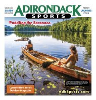
JULY <strong>2023</strong> 11<br />
A BOREAS PONDS<br />
VIEW – LILY PADS AND<br />
MOUNTAINS.<br />
VIEW OF GOTHICS<br />
AND SAWTEETH FROM<br />
BOREAS PONDS.<br />
A BOGGY ISLAND IS<br />
ATTACHED TO A HUGE<br />
BOULDER IN THE<br />
MIDDLE OF THE PONDS.<br />
PHOTOS BY RICH MACHA<br />
PADDLING, HIKING & CAMPING<br />
Boreas Ponds Update<br />
By Rich Macha<br />
It comes as no surprise that the Boreas<br />
Ponds area has become a popular<br />
destination for folks who are willing<br />
to expend just a little effort so as to<br />
experience the incomparable view of<br />
the <strong>Adirondack</strong> High Peaks from across<br />
its waters. Access was limited in 2022<br />
due to the fact that the road bridge over<br />
the Boreas River at LaBier Flow needed<br />
replacement, but as of late May of this<br />
year, things are back to normal and the<br />
general public can drive the dirt and gravel<br />
Gulf Brook Road for 5.8 miles to at least<br />
the Four Corners parking area.<br />
Before the dam was built, there were<br />
three separate ponds (1st, 2nd, and 3rd)<br />
– hence the plural in Boreas Ponds – with<br />
the dam, the result is one big 320-acre<br />
pond. The land around the ponds is classified<br />
as “Wilderness” where motors are<br />
not allowed, whereas most of the land to<br />
the south of the ponds was placed in the<br />
Vanderwhacker Mountain Wild Forest. A<br />
“Wild Forest” designation could allow for<br />
some motorized usage.<br />
In June, a couple of friends and I were<br />
able to take advantage of some fair weather<br />
and spend three days of camping, paddling,<br />
and hiking in the area. This was my<br />
third visit to the ponds and my second<br />
that involved camping out. From the Four<br />
Corners parking area, we used carts to<br />
wheel our canoes and kayak 0.9 miles on<br />
a relatively smooth dirt and gravel road<br />
to the put-in at the dam. Along the way<br />
we passed a short carry to LaBier Flow, a<br />
small parking area that requires a permit,<br />
and then a sharp left turn that leads to a<br />
lean-to – at this time it’s the only designated<br />
campsite at the ponds although up to<br />
five campsites are in the plans.<br />
Paddling – Once we had set up camp<br />
at the lean-to, we paddled the perimeter<br />
of the ponds in a counterclockwise direction.<br />
From south to north, the straight-line<br />
length of the ponds is only 1.5 miles, but<br />
by following its convoluted shoreline, you<br />
can easily paddle over five miles. Most of<br />
the shoreline consists of a dense growth of<br />
spruce and balsam fir and there is a definite<br />
lack of good places to land if you are<br />
looking for a break or to stop for a picnic<br />
lunch. The mountain views gained from a<br />
variety of locations do compensate however<br />
– Mount Marcy, Mount Haystack,<br />
and the rock face of Gothics stand out,<br />
although Allen Mountain makes its presence<br />
known because of its proximity to<br />
the ponds. The North River Mountains<br />
and Cheney Cobble loom to the west, and<br />
Boreas Mountain dominates to the east.<br />
Paddlers can find themselves pushing<br />
through froggy lily pads and, soon after,<br />
skirting the skeletons of drowned trees.<br />
Watch for loons diving after fish and the<br />
heads of curious otters popping up from<br />
the water, while grunting at the sight of the<br />
interlopers, before making a quick disappearance.<br />
Keep an eye out for great blue<br />
herons and, if you are lucky, a moose.<br />
On day two, we paddled to the north<br />
end of the ponds and hiked over a mile<br />
on old logging roads to White Lily Pond.<br />
When we returned to our boats after the<br />
hike, we made our way in and out of the<br />
islands as we headed back to camp. Some<br />
of the islands are covered in dense spruce<br />
and fir like most of the shoreline, but there<br />
are also many fascinating boggy islands<br />
with pitcher plants, sundews, and other<br />
vegetation that is usually associated with<br />
bogs. One boggy island has a huge boulder<br />
attached to it. A swim by the dam can<br />
be a satisfying end to the day.<br />
Hiking – As of June <strong>2023</strong>, there were no<br />
marked hiking trails in the area although<br />
several are planned. For the time being,<br />
you can hike extensively on old logging<br />
roads, some of which are shown on certain<br />
maps and some advance research is<br />
necessary if you plan to go any distance.<br />
White Lily Pond, near the foot of Allen<br />
Mountain, makes for an attractive destination.<br />
We paddled to the north end of the<br />
ponds and left our boats at the inlet, then<br />
hiked on a hardened logging road going<br />
in a northwest direction. We soon gained<br />
almost 300 feet before dropping to a small<br />
clearing on the left where another logging<br />
See PADDLING, HIKING & CAMPING 13 ▶