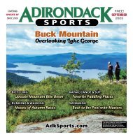
Adirondack Sports June 2023
IN THIS ISSUE 1 PADDLING: St. Regis Canoe Area Made Easy 3 RUNNING & WALKING: The Summer Place To Be 7 BICYCLING: Summer Tours and Rides 9 HIKING & BACKPACKING: Wilson Pond 11 SWIMMING & TRIATHLON: Mastering the Open Water 13 COMMUNITY: Adirondack 46er 15 ATHLETE PROFILE: Triathlon with Jason Hare 16-21 CALENDAR OF EVENTS: Many Summer Things to Do 24-27 RACE RESULTS: Top Finishers in Recent Races
IN THIS ISSUE
1 PADDLING: St. Regis Canoe Area Made Easy
3 RUNNING & WALKING: The Summer Place To Be
7 BICYCLING: Summer Tours and Rides
9 HIKING & BACKPACKING: Wilson Pond
11 SWIMMING & TRIATHLON: Mastering the Open Water
13 COMMUNITY: Adirondack 46er
15 ATHLETE PROFILE: Triathlon with Jason Hare
16-21 CALENDAR OF EVENTS: Many Summer Things to Do
24-27 RACE RESULTS: Top Finishers in Recent Races

You also want an ePaper? Increase the reach of your titles
YUMPU automatically turns print PDFs into web optimized ePapers that Google loves.
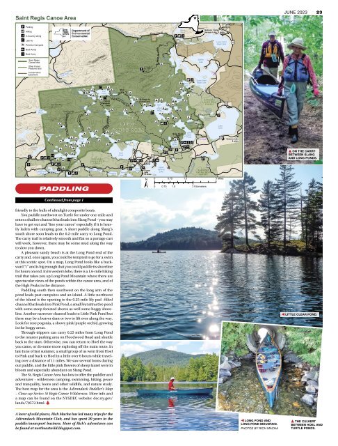
Saint Regis Canoe Area<br />
!j<br />
!J<br />
(<br />
!0<br />
Cranberry<br />
Pond<br />
Windfall<br />
Pond<br />
Parking<br />
Hiking<br />
X-Country skiing<br />
Lean-to<br />
!8 Primitive Campsite<br />
!y<br />
!|<br />
Boat Ramp<br />
Boat Carry<br />
!<br />
Saint Regis<br />
Canoe Area<br />
Other Forest<br />
Preserve land<br />
Conservation<br />
Easement<br />
!j<br />
!<br />
!j<br />
Dry<br />
Channel<br />
Pond<br />
East<br />
Pond<br />
East Pond Mtn<br />
Long Pond Mtn<br />
2530'<br />
Long<br />
! !8<br />
!<br />
!8<br />
!<br />
!8 !<br />
!<br />
!8<br />
!8<br />
!<br />
!8 !8<br />
Pink !8<br />
!<br />
!<br />
Pond<br />
!8 !8 !<br />
!|<br />
!<br />
! !<br />
!j!J!( !<br />
!!<br />
!<br />
!8 !| !8<br />
!<br />
!8<br />
!j!J!(<br />
!j !8<br />
East Pine ! !<br />
Pd<br />
!j !J!(<br />
West Pine<br />
Pond<br />
Ledge<br />
Pd<br />
!8<br />
!<br />
Mountain<br />
Pond<br />
Cat Pond<br />
Pond Mountain Trl<br />
S ara n ac L ak es<br />
Wi ld F or es t<br />
Long to Bessie Carry<br />
!<br />
Long<br />
Pond<br />
!<br />
!8<br />
!8<br />
!8<br />
!8<br />
Lydia ! !<br />
Pond<br />
Little !<br />
Long Pond<br />
Nellie<br />
Pond<br />
!8<br />
!8<br />
!8<br />
!<br />
!8<br />
!8<br />
!j<br />
PADDLING<br />
!<br />
F<br />
!<br />
!<br />
Bessie<br />
Pd<br />
!<br />
!<br />
!8<br />
Slang !<br />
Pond<br />
!0<br />
!<br />
l oodwood Rd<br />
Pond<br />
!8<br />
!0<br />
!8<br />
T urtle<br />
!<br />
S AR A NA C<br />
LA K E S W I LD<br />
FO R E S T<br />
Middle<br />
!<br />
Fish<br />
Pond<br />
!8<br />
!<br />
! !8<br />
!<br />
Fish to<br />
Clamshell<br />
Carry<br />
Clamshell<br />
Pond<br />
lamshell<br />
to C<br />
!<br />
C a rry<br />
Saint Regis River<br />
Fish Pond Truck Trl<br />
!8<br />
Pond<br />
!<br />
!<br />
!8<br />
!<br />
S A I N T R E G I S<br />
M O U N TA I N<br />
F I R E T O W E R<br />
H I S TO R I C A R E A<br />
S A I N T<br />
R E G I S<br />
C A N O E A R E A<br />
!8 !8<br />
!8<br />
Mud<br />
Pond<br />
!<br />
Turtle<br />
Pond<br />
! !<br />
Polliwog<br />
!8<br />
Mud<br />
Ochre<br />
Grass<br />
Pond<br />
Hoel<br />
Pond<br />
!j<br />
!<br />
t o<br />
Carry<br />
!8<br />
!8<br />
!<br />
!<br />
!j!| !J!(<br />
!j<br />
!8<br />
!<br />
!8<br />
!A<br />
!<br />
!<br />
!8<br />
!j<br />
St. Regis<br />
Mtn 2874'<br />
! St. Regis to<br />
Ochre Carry<br />
Ochre<br />
Pd !8<br />
! !<br />
Green<br />
Pond !<br />
!8<br />
Little<br />
Rainbow<br />
Pond<br />
?l<br />
!<br />
?¬<br />
Tupper<br />
Lake<br />
±<br />
E 14 miles<br />
Keese Mills Rd<br />
!0<br />
!<br />
Regis<br />
Pond<br />
!8<br />
!<br />
!8<br />
!8<br />
!<br />
!8<br />
! !8<br />
Saint<br />
!8 !8<br />
!<br />
!8<br />
!<br />
!<br />
!<br />
St.<br />
Mountain<br />
Regis<br />
!j!y<br />
Trl<br />
!<br />
!j !J!(<br />
Marvin<br />
Pond<br />
!<br />
Little<br />
Long<br />
Pond !<br />
!<br />
!<br />
!8<br />
!8<br />
!<br />
!8<br />
!8<br />
!8<br />
!J !(<br />
!<br />
!<br />
!8<br />
!8<br />
!<br />
Saranac River<br />
Spitfire<br />
Lake<br />
Upper Saint<br />
Regis Lake<br />
ond Trl<br />
Meadow P<br />
!<br />
E<br />
Gabriels 3 miles<br />
Saranac Lake 11 miles<br />
S AR A NA C<br />
LA K E S W I LD<br />
FO R E S T<br />
Roiley<br />
!<br />
!8<br />
!!8<br />
Pond<br />
!<br />
!j<br />
!<br />
! !8 !8<br />
!8<br />
Meadow<br />
!<br />
Pond<br />
!<br />
!<br />
Grass<br />
!J!(<br />
!8<br />
Pond<br />
Little<br />
Bone Pond<br />
Truck Clear<br />
Bone Trl Pond<br />
Pd<br />
!<br />
!8<br />
!<br />
Little<br />
Green<br />
!j !| !F!(<br />
! Pond !<br />
Rat<br />
!j!|<br />
Pd<br />
!<br />
!j !j !j !<br />
Upper<br />
Saranac<br />
Lake<br />
Spectacle<br />
Ponds<br />
Black<br />
Pond<br />
Green<br />
Pond<br />
! Bear<br />
Pd<br />
^<br />
!j<br />
Saint<br />
Germain<br />
Pond<br />
?ì<br />
S AR A NA C<br />
LA K E S W I LD<br />
FO R E S T<br />
Lower Saint<br />
Regis Lake<br />
Lake<br />
Clear<br />
0 0.75 1.5 3 Miles<br />
0 0.75 1.5 3 Kilometers<br />
?l<br />
?l<br />
?á<br />
?l<br />
Saranac Lake<br />
8 miles<br />
E<br />
10/2017<br />
JUNE <strong>2023</strong> 23<br />
▲ ON THE CARRY<br />
BETWEEN SLANG<br />
AND LONG PONDS.<br />
Continued from page 1<br />
friendly to the hulls of ultralight composite boats.<br />
You paddle northwest on Turtle for under one-mile and<br />
enter a shallow channel that leads into Slang Pond – you may<br />
have to get out and ‘line your canoe’ especially if it is heavily<br />
laden with camping gear. A short paddle along Slang’s<br />
south shore soon leads to the 0.2-mile carry to Long Pond.<br />
The carry trail is relatively smooth and flat so a portage cart<br />
will work, however, there may be some mud along the way<br />
to slow you down.<br />
A pleasant sandy beach is at the Long Pond end of the<br />
carry and, once again, you could be tempted to go for a swim<br />
at this scenic spot. On a map, Long Pond looks like a backward<br />
“t” and is big enough that you could paddle its shoreline<br />
for hours on end. In its western lobe, there is a 1.6-mile hiking<br />
trail that takes you up Long Pond Mountain where there are<br />
spectacular views of the ponds within the canoe area, and of<br />
the High Peaks in the distance.<br />
Paddling south then southwest on the long arm of the<br />
pond leads past campsites and an island. A little northwest<br />
of the island is the opening to the 0.25-mile lily pad –filled<br />
channel that leads into Pink Pond, a small but attractive pond<br />
with some steep forested shores as well some boggy shoreline.<br />
Another narrower channel leads to Little Pink Pond but<br />
there may be a beaver dam or two to lift over along the way.<br />
Look for rose pogonia, a showy pink/purple orchid, growing<br />
in the boggy areas.<br />
Through-trippers can carry 0.25 miles from Long Pond<br />
to the nearest parking area on Floodwood Road and shuttle<br />
back to the start. Otherwise, you can return to Hoel the way<br />
you came, or do some more exploring off the main route. In<br />
late <strong>June</strong> of last summer, a small group of us went from Hoel<br />
to Pink and back to Hoel in a little over 6 hours while traveling<br />
over a distance of 11 miles. We saw several loons during<br />
our paddle, and the little pink flowers of sheep laurel were in<br />
bloom and especially abundant on Slang Pond.<br />
The St. Regis Canoe Area has lots to offer the paddler and<br />
adventurer – wilderness camping, swimming, hiking, peace<br />
and tranquility, loons and other wildlife, and nature study.<br />
The best map for the area is the <strong>Adirondack</strong> Paddler’s Map<br />
– Close-up Series: St Regis Canoe Wilderness. More info and<br />
a map can be found on the NYSDEC website: dec.ny.gov/<br />
lands/70572.html.<br />
◀ LITTLE CLEAR POND.<br />
A lover of wild places, Rich Macha has led many trips for the<br />
<strong>Adirondack</strong> Mountain Club, and has spent 20 years in the<br />
paddle/snowsport business. More of Rich’s adventures can<br />
be found at northeastwild.blogspot.com.<br />
◀ LONG POND AND<br />
LONG POND MOUNTAIN.<br />
PHOTOS BY RICH MACHA<br />
▲ THE CULVERT<br />
BETWEEN HOEL AND<br />
TURTLE PONDS.