green-solutions - Full-Service für outdoor destinations

Create successful ePaper yourself
Turn your PDF publications into a flip-book with our unique Google optimized e-Paper software.
FULL<br />
SERVICE<br />
For Outdoor Destinations<br />
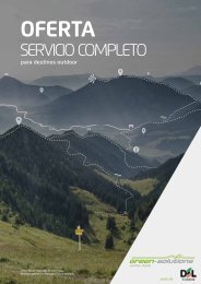
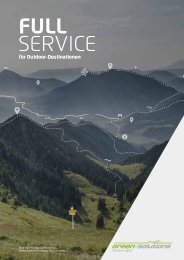
Photo: View from Hochfein in Chiemgau.<br />
Many thanks to Chiemgau Tourism Association.<br />
<strong>outdoor</strong> digital
OUTDOOR<br />
DIGITAL
OUTDOOR<br />
DIGITAL<br />
This is the mantra of <strong>green</strong>-<strong>solutions</strong>. Our team consists<br />
of planners, geo-information specialists, cartographers,<br />
graphic designers, environmental scientists, and programmers,<br />
who develop state-of-the-art and sustainable<br />
<strong>solutions</strong> at the intersection of technology, tourism, and<br />
conservation. Whether it‘s <strong>outdoor</strong> concepts, data collection<br />
and route tracking, digital tour management, cartography,<br />
GIS services, signage systems, or web technology<br />
and mobile applications – you will definitely find the specialists<br />
for your region and your individual projects with us.<br />
Our full-service support is unique in the market: we provide<br />
our customers with tailored comprehensive packages<br />
from planning to implementation and marketing. With us,<br />
you will receive cutting-edge technology and professional<br />
support in realizing your projects.<br />
OUR GOAL: SUSTAINABLE SOLUTIONS AND SATISFIED CUSTOMERS
SERVICE<br />
PORTFOLIO<br />
OUTDOOR DIGITAL<br />
01<br />
DISCOVERY<br />
PHASE<br />
From an idea to a product.<br />
05<br />
INSTALLATION<br />
ON SITE<br />
Actualize your plan in the field.<br />
06<br />
QUALITY<br />
MANAGEMENT<br />
Maintenance and care to ensure the<br />
quality of your project.<br />
10<br />
FOCUSSED<br />
THEMES<br />
Reach your specific <strong>outdoor</strong><br />
target audience.<br />
09<br />
MEDIA<br />
DESIGN<br />
The right medium for<br />
every purpose and goal.
02<br />
CONCEPT<br />
DEVELOPMENT<br />
Forward-looking planning to<br />
ensure your long-term success.<br />
03<br />
TOUR<br />
INFRA<br />
Manage your <strong>outdoor</strong><br />
destination on the web.<br />
04<br />
SIGNAGE &<br />
WAYFINDING<br />
As much as necessary,<br />
as little as possible.<br />
07<br />
DIGITAL<br />
INTERFACE<br />
For a successful online presence.<br />
08<br />
CARTO<br />
GRAPHY<br />
Combining aesthetics and utility.
www.<strong>green</strong>-<strong>solutions</strong>.info/dienstleistungen-produkte/angebotsentwicklung<br />
DISCOVERY<br />
PHASE<br />
From an idea to a product.<br />
DISCOVERY PHASE<br />
Leisure and recreation are becoming increasingly important.<br />
More and more people want to get <strong>outdoor</strong>s<br />
and enjoy nature. However, as interest rises, so does<br />
the demand for quality and authentic experiences in<br />
the <strong>outdoor</strong>s.<br />
We are your partner in developing your region‘s recreational<br />
potential and can help you to successfully market<br />
the best of what your region has to offer. What<br />
is your region’s target market? What expectations do<br />
they have of your destination? We help you make those<br />
expectations a reality based on the natural and cultural<br />
potential of your area. We work in coordination with all<br />
relevant stakeholders including government, foresters,<br />
hunters, nature conservationists, landowners, and associations<br />
and clubs.<br />
We bring holistic expertise, passion, and many years<br />
of project experience to the table - all to support your<br />
goals and success.<br />
Process guidance<br />
Community-data analysis<br />
The latest technology<br />
Dynamic navigation systems<br />
Our great strength stems from being an interdisciplinary<br />
team with a wide range of expertise. We are<br />
geographers, land planners, environmental scientists,<br />
geo-information specialists, cartographers, graphic-designers,<br />
and programmers – and at the same time, we<br />
are enthusiastic hikers, cyclists, mountaineers, mountain<br />
bikers, ski tourers, and cross-country skiers.<br />
- 06 -
- 07 -
www.<strong>green</strong>-<strong>solutions</strong>.info/dienstleistungen-produkte/<strong>outdoor</strong>-konzepte<br />
CONCEPT DEVELOPMENT<br />
CONCEPT-<br />
DEVELOPMENT<br />
Forward-looking planning to<br />
ensure your long-term success.<br />
Don‘t leave your guests stranded! It‘s simply not<br />
enough to have a website, a mobile app, or traditional<br />
print media. Successful <strong>outdoor</strong> <strong>destinations</strong> also<br />
need to have the right infrastructure in the right places<br />
to ensure that guests aren‘t lost in the woods.<br />
Present your information professionally and meaningfully<br />
with well-organized information boards. Make<br />
your region shine with carefully planned and well-executed<br />
signage. Following the motto of “quality over<br />
quantity,“ it‘s essential to assess and revise existing<br />
trail networks, especially in sensitive areas, and to<br />
optimize the experiences that your region offers. This<br />
requires a comprehensive and empathetic planning<br />
process to meet all interests and needs.<br />
Collaborate with us to plan offerings that not only hit<br />
the mark with your target audience but also receive<br />
acceptance and engagement from authorities and the<br />
local community.<br />
GIS analysis, and our experience and intuition during<br />
the stakeholder engagement process. With us as your<br />
partner, you will ensure your destination’s ongoing<br />
success!<br />
Comprehensive planning process<br />
Advanced planning technology<br />
Visitor flow analysis<br />
Standardized signage systems<br />
Know-how in EU-funded projects<br />
To achieve this, we rely on comprehensive and reliable<br />
on-site data collection and field surveys, standardized<br />
- 08 -
MOUNTAIN BIKE WORKING GROUP<br />
Mountain biking is booming! According to surveys,<br />
around 15 million people in Germany engaged in<br />
mountain biking as a leisure activity in 2017<br />
(Source: Statista 2017, IfD Allensbach).<br />
data, interactive maps, and elevation profiles for your<br />
tour portal, to help you present your exciting new<br />
mountain biking possibilities to new tourists.<br />
The Mountain Bike Working Group brings together four<br />
specialists with extensive experience working in various<br />
fields related mountain biking.<br />
We are here to provide you with comprehensive guidance<br />
on sustainable strategies for mountain bike tourism.<br />
We provide expert knowledge and consultation<br />
that serves as a valuable decision-making resource for<br />
committees and policymakers. Together we develop<br />
custom-tailored trail plans for your target audience.<br />
Additionally, we provide on-site signage, create GPS<br />
- 09 -
www.<strong>green</strong>-<strong>solutions</strong>.info/dienstleistungen-produkte/tourinfra<br />
TOUR<br />
INFRA<br />
Manage your <strong>outdoor</strong><br />
destination on the web.<br />
- 10 -
tourinfra® Tour & Infrastructure<br />
Management for Professionals<br />
tourinfra® offers much more than other tour management<br />
systems. Only with us will you receive the complete<br />
solution for your region.<br />
With tourinfra® you can:<br />
• Create trip suggestions for your guests (including<br />
route descriptions, maps, and elevation profiles).<br />
tour<br />
infra<br />
• Stay updated on real-time trail closures and restrictions<br />
online.<br />
• Generate web and print maps conveniently online.<br />
• Curate your region‘s recreational opportunities for<br />
your guests.<br />
• Plan, maintain, and order infrastructure elements,<br />
such as wayfinding signs and viewpoint benches.<br />
• Calculate sign contents (e.g., distance and walking<br />
time) quickly and easily using our automated tools.<br />
• Design signs according to current standards.<br />
• Verify and directly order signage and mounting materials<br />
from sign manufacturers through our online<br />
preview feature.<br />
Contract Management<br />
Tour Management<br />
Route Control<br />
Infrastructure<br />
Closures<br />
Quality Control<br />
- 11-
www.<strong>green</strong>-<strong>solutions</strong>.info/dienstleistungen-produkte/tourinfra<br />
Overview page with a filterable list of existing tours and current status.<br />
Detailed page for each tour, with route description and relevant information.<br />
Multiple tools available to quickly edit or update a route and it‘s information.<br />
- 12 -
Tours – the number one marketing<br />
asset for <strong>outdoor</strong> <strong>destinations</strong>.<br />
In tourinfra®, tours can be quickly created for a variety<br />
of <strong>outdoor</strong> activities including hiking, mountain<br />
biking, trail running, road cycling, cross-country skiing,<br />
and many more. Multiple online tools and automated<br />
steps help make this process simple and user-friendly,<br />
including the creation of routes via GPS data, terrain<br />
routing functions, and automatic synchronization<br />
with OpenStreetMap‘s map data. The online presentation<br />
of your tours can be enriched with a wealth<br />
of relevant information for your guests, including the<br />
integration of points of interest (POIs).<br />
To keep you and your guests up-to-date on current<br />
conditions, tourinfra® features a system that alerts<br />
and warns about hazards and closures in real-time. In<br />
the future, the system will be designed to automatically<br />
report closures based on sensor data (e.g., flood<br />
sensors or rockfalls), further enhancing the safety of<br />
your guests in real-time..<br />
tour<br />
infra<br />
Manage your <strong>outdoor</strong><br />
destination online.<br />
Tours linked with POIs including tourists highlights, events, and gastronomy.<br />
- 13-<br />
- 07 -
www.<strong>green</strong>-<strong>solutions</strong>.info/dienstleistungen-produkte/tourinfra<br />
TOUR<br />
INFRA<br />
Manage your <strong>outdoor</strong><br />
destination online.<br />
- 14 -
tourinfra® – Plan, manage,<br />
and maintain your signage<br />
with just a few clicks.<br />
Wayfinding systems and infrastructure elements<br />
such as information boards and viewpoint benches<br />
require significant investment and time for tourism<br />
regions. The planning, management, and maintenance<br />
of these wayfinding systems are core features<br />
of tourinfra®. Our system assists you in planning and<br />
creating signage, starting from route numbering to<br />
automatic sign generation and direct ordering from<br />
your service provider. The map views and search<br />
functions enable convenient and intuitive management<br />
of even large <strong>destinations</strong>.<br />
Infraviewer: Your region‘s infrastructure at a glance.<br />
With tourinfra®, the endless searching in documents<br />
and Excel sheets is a thing of the past. Simply select<br />
the desired position on the map, and all information<br />
will be displayed clearly and concisely. And the best<br />
part is that you can take all the information from<br />
your desktop screen with you on tourinfra® mobile in<br />
your pocket! Furthermore, tourinfra® mobile is 100%<br />
offline-capable, ensuring that you have all the data<br />
at your fingertips, even deep in the backcountry.<br />
Trail networks and corresponding signage.<br />
tourinfra® and tourinfra®mobile - it‘s as simple as<br />
that!<br />
Detailed information view with one click.<br />
Every location and all infrastructure at your fingertips.<br />
- 15-<br />
- 07 -
www.<strong>green</strong>-<strong>solutions</strong>.info/dienstleistungen-produkte/tourinfra<br />
TOUR<br />
INFRA<br />
Manage your <strong>outdoor</strong><br />
destination online.<br />
- 16 -
tourinfra® – Much more than<br />
just tours and signs<br />
The challenges in tourism are growing year by year<br />
and the global importance of sustainable tourism is<br />
increasing. This global trend is also reflected at the<br />
local level for each individual destination. Tourinfra<br />
provides technical tools to meet these challenges.<br />
For example, to avoid conflicts or disappointed<br />
guests, trail closures due to forestry work can be<br />
communicated to guests in advance. Or when creating<br />
and mapping tours, information about protected<br />
areas is displayed and can be taken into account<br />
during the planning process.<br />
Real-time information about closures and conditions.<br />
Our feedback reporting feature allows information<br />
from community users to be integrated and shared,<br />
allowing for up-to-date conditions tracking.<br />
Tourinfra also supports data distribution. It structures<br />
your tour information for the future and makes it accessible<br />
for AI applications. Through data delivery via<br />
a graph database, tour information can be combined<br />
with a variety of additional information and effectively<br />
utilized in chatbots and similar developments<br />
using AI.<br />
Protected areas in tourinfra® help avoid conflicts.<br />
Centralized system for managing damage reports.<br />
Graph database for storing tourist data.<br />
- 17-<br />
- 07 -
www.<strong>green</strong>-<strong>solutions</strong>.info/dienstleistungen-produkte/leitsysteme<br />
SIGNAGE<br />
& WAYFINDING<br />
As much as necessary,<br />
as little as possible.<br />
- 18 -
SIGNAGE &<br />
WAYFINDING<br />
With <strong>green</strong>-<strong>solutions</strong>, travel halfway around the world!<br />
Over the past years, we have professionally mapped<br />
and signposted over 20,000 kilometres of routes. We<br />
have also developed and successfully implemented<br />
signage systems for a wide variety of sports.<br />
Outdoors, digitally: Using state-of-the-art technology,<br />
we digitally capture the terrain based on route planning<br />
and in coordination with all relevant stakeholders.<br />
Building upon our digital data, we then meticulously<br />
and accurately plan your infrastructure and signage.<br />
Our full-service package is unparalleled in the market.<br />
We automatically generate sign printing templates,<br />
determine material requirements, provide guidance<br />
on selecting signs and mounting materials, and assist<br />
with tender creation.<br />
Based on the data in tourinfra®, the signage system is<br />
then installed on-site - by the destination, municipality,<br />
external service providers, or optionally by our installation<br />
team.<br />
With <strong>green</strong>-<strong>solutions</strong> and tourinfra®, you will never get<br />
lost in the (signage) forest!<br />
On-site data collection & planning<br />
Digitization of your systems<br />
Standardized guidance systems<br />
Quantity calculation<br />
Online print production<br />
Experience and support in the bid<br />
writing process<br />
- 19-
SIGNAGE &<br />
WAYFINDING<br />
Experience is irreplaceable except with more experience!<br />
For over 15 years, we have been offering<br />
individually tailored <strong>solutions</strong> for the selection and<br />
implementation of wayfinding systems and routing<br />
signage for tourist <strong>destinations</strong>. In the future, we will<br />
increasingly integrate guidance systems with digital<br />
dynamic systems. Because one thing is clear: digital<br />
guidance systems are unstoppable in the <strong>outdoor</strong><br />
sector. We are currently developing autonomous,<br />
dynamic guidance systems that can be administered<br />
directly from tourinfra®, sensor-controlled.<br />
Going digital <strong>outdoor</strong>s - with <strong>green</strong>-<strong>solutions</strong>, you<br />
take your visitor management to a whole new level!<br />
- 20 -
Gefördert durch das Bayerische Staatsministerium <strong>für</strong> Ernährung, Landwirtschaft<br />
und Forsten und den Europäischen Landwirtschaftsfonds <strong>für</strong> die Entwicklung des<br />
ländlichen Raums (ELER).<br />
639001.pdf 1 05.09.21 17:34<br />
Uracher Wasserfall ·<br />
Rutschenfelsen ¯<br />
Burgruine Hohenurach ¯<br />
1,8 km<br />
3,1 km<br />
2,6 km<br />
Huberspitz-<br />
Gindelalm-Runde<br />
Ziel:<br />
8<br />
noch 3,4 km<br />
Gesamtstrecke:<br />
10,7 km 510 hm<br />
Steigenfelskapelle Kreuzweg K 0.6 km / 0:20 h<br />
Buchhüttenschachten via Rothsallebene 3 km / 1:30 h<br />
Chamer Hütte 1.289 m FM 4.8 km / 2:00 h<br />
Bo-0617 Bäckerebene 844 m ü.NN<br />
UTM 33 360985 / 5438097<br />
m<br />
1.400<br />
1.200<br />
PARKPLATZ<br />
Volksfestplatz<br />
abzweig<br />
alternativroute<br />
GindelalmEN<br />
Almbad<br />
Huberspitz<br />
abzweig<br />
alternativroute<br />
PARKPLATZ<br />
Volksfestplatz<br />
1.000<br />
800<br />
600<br />
0<br />
1 2 3 4 5 6 7 8 9 10<br />
10,7 km<br />
Neubäu am See<br />
Falkenstein<br />
Mountainbike Trans Bayerwald / Südroute<br />
20km<br />
54km<br />
250hm<br />
870hm<br />
CHA-0282<br />
- 21 -
www.<strong>green</strong>-<strong>solutions</strong>.info/dienstleistungen-produkte/montageservice-qualitaetsmanagement<br />
INSTALLATION<br />
Actualize your plan in the field.<br />
INSTALLATION<br />
After ordering your signs from tourinfra®, the next<br />
step is installation. Here, tourinfra® demonstrates<br />
its strength once again: your installation team can<br />
access the sign planning with specific location data<br />
<strong>outdoor</strong>s in the field using our tool. Whether digitally<br />
through tourinfra®mobil or analogue through data<br />
sheets, you can quickly and easily install your new<br />
signage.<br />
Need a partner for installation? No problem! If needed,<br />
we can handle your installation work or connect<br />
you with one of our competent partners.<br />
Once you have successfully installed your signage,<br />
the construction acceptance and future quality assurance<br />
can be easily done through tourinfra® and<br />
tourinfra®mobil, just like the previous steps. That‘s<br />
what we call system integration.<br />
Professional installation<br />
Digital documentation of the work<br />
Quality management<br />
Damage reporting<br />
- 22 -
- 23-
www.<strong>green</strong>-<strong>solutions</strong>.info/dienstleistungen-produkte/montageservice-qualitaetsmanagement<br />
QUALITY<br />
MANAGEMENT<br />
Maintenance and care to ensure<br />
the quality of your project.<br />
- 24 -
QUALITY ASSURANCE<br />
& MANAGEMENT<br />
Many <strong>destinations</strong> face similar challenges: on one<br />
hand, they are growing larger, and on the other<br />
hand, there is a decreasing availability of personnel.<br />
The solution to this dilemma is a seamless workflow<br />
from reporting the damage, capturing the defects,<br />
taking action to remedy the issues, and handling<br />
the process. With tourinfra®, both guests and local<br />
trail volunteers can be flexibly involved. With the<br />
accompanying route inspections, <strong>destinations</strong> always<br />
have an overview of which trail sections need to be<br />
controlled in the future. Protocols and information<br />
can be conveniently captured and shared during<br />
inspections using the app. In tourinfra®, the information<br />
on defects is centrally managed and delegated<br />
to municipal maintenance departments and contractors.<br />
The assigned tasks can be accessed by the local<br />
maintenance departments through tourinfra® mobile.<br />
Once a defect is repaired, the completed work can be<br />
confirmed with a single click in tourinfra® mobile.<br />
A photo can also be added as confirmation, and then<br />
it‘s ready to move on. This efficient workflow allows<br />
for more time to focus on maintaining the trails in<br />
your region, while administrative overhead decreases<br />
rapidly.<br />
- 25 -
www.<strong>green</strong>-<strong>solutions</strong>.info/dienstleistungen-produkte/tourenmodul<br />
DIGITAL<br />
INTERFACE<br />
For a successful online presence.<br />
- 26 -
Responsive Routing Module<br />
The open routing module from <strong>green</strong>-<strong>solutions</strong> allows<br />
your guests to plan individual tours. Whether it‘s<br />
hiking or cycling, simply enter a destination and, if<br />
desired, intermediate points (as text, place, or street<br />
names) or click on the zoomable map, and the routing<br />
module will present you with a perfect tour tailored to<br />
your preferences!<br />
• Routing based on OSM data or custom road networks<br />
• Routing with multiple waypoints<br />
• Inclusion of your region‘s POIs, gastronomy, accommodation,<br />
etc.<br />
• Scaled map available to print and take with you<br />
• Downloadable GPS data<br />
• Responsive detailed pages for POIs, events, dining<br />
& accommodations<br />
Tour Module example: www.bayerischer-wald.de<br />
Responsive Tour Module<br />
Cross-country ski trails: www.bodenmais.de<br />
Your guests want to go hiking, cycling, or simply explore<br />
the surroundings?<br />
Then professionally present the diverse <strong>outdoor</strong><br />
opportunities of your region on your website using<br />
our tour module. The module will be provided as a<br />
Progressive Web App in the future.<br />
• SEO optimization for your website<br />
• Design freedom for your web page<br />
• Responsive search and route information page<br />
• Result pages as list, gallery, and split view<br />
• Various customization options<br />
• 2D and 3D route plan<br />
• Dynamic elevation profiles<br />
• Weather data and snow information<br />
• Route printout also available as a scaled map<br />
• Various GPS data formats available for download<br />
• Responsive info pages for Points of Interest (POI),<br />
Events, Gastronomy, and Accommodations<br />
• Activity type (e.g. Hiking or Biking) as entry page<br />
• Destination Module as a variant of the Route<br />
Module<br />
Tour display: Oberpfälzer Wald „Natur-Navi“<br />
Routing Module: Emsland<br />
- 27 -
www.<strong>green</strong>-<strong>solutions</strong>.info/dienstleistungen-produkte/kartographie<br />
CARTOGRAPHY<br />
For a successful presentation<br />
- 28 -
CUSTOM CARTOGRAPHY<br />
We make maps!<br />
And we make them as unique as your destination!<br />
Green-<strong>solutions</strong> offers an extensive range of map<br />
products: from city maps to hiking and <strong>outdoor</strong> maps,<br />
to interactive maps for your website or app. And of<br />
course, everything is designed according to your preferences.<br />
We are specialists when it comes to Open-<br />
StreetMap (OSM) data. Through our sophisticated production<br />
process, we quickly generate high-quality and<br />
highly accurate map data, which we then customize<br />
according to your specific needs and requirements.<br />
With hundreds of map projects completed over<br />
the years, we have gained a wealth of experience<br />
and expertise in map production. This enables us<br />
to provide optimal advice and creative support in<br />
developing maps tailored to your target audience.<br />
We adapt our level of implementation to your preferences<br />
and demands. We are more than happy to<br />
handle everything from concept development, map<br />
types, design of print products, to printing and shipping,<br />
all under one roof. <strong>Full</strong>-service is in our DNA. By<br />
the way, your destination deserves more than just<br />
casual snapshots and Wikipedia texts. That‘s why our<br />
partners also provide professional text and image<br />
materials. And it goes without saying that our maps,<br />
texts, and photos are all royalty- and licence-free for<br />
you to use.<br />
Licence-free and budget-friendly<br />
Completely up-to-date<br />
Individual custom design<br />
Available world-wide<br />
All scales and sizes<br />
All file formats<br />
- 29 -
werk<br />
www.<strong>green</strong>-<strong>solutions</strong>.info/dienstleistungen-produkte/kartographie<br />
Moorpforten/<br />
Veenpoorten<br />
A Emsland Moormuseum<br />
B Erdöl-Erdgas-Museum<br />
C Veenpark<br />
D Veenloopcentrum<br />
E Smalspoormuseum<br />
F Van-Gogh-Huis<br />
G Collectie Brands<br />
H D-NL Bienenzentrum<br />
www.naturpark-moor.eu<br />
www.natuurpark-veenland.eu<br />
www.naturpark-routenplaner.de<br />
73<br />
Europäische Union<br />
Europese Unie<br />
Legenda / Legende<br />
Groningen<br />
Groningen<br />
DRENTHE<br />
DRENTHE<br />
Emmen<br />
Emmen<br />
EMSLAND<br />
EMSLAND<br />
Meppen<br />
Meppen<br />
Zwolle<br />
Zwolle<br />
GRAFSCHAFT<br />
GRAFSCHAFT<br />
BENTHEIM<br />
BENTHEIM<br />
Nordhorn<br />
Nordhorn<br />
Enschede<br />
Enschede<br />
5<br />
15<br />
1,6<br />
Ihr Standort / Uw locatie<br />
Knotenpunkt / Knooppunt<br />
Streckennetz mit<br />
km-Angabe /<br />
Routennetwerk met km<br />
Landesgrenze / Grens<br />
Schutzgebiet /<br />
Natuurgebieden<br />
Kartengrundlage©OpenStreetMap contributors<br />
Moorgebiet - Heide /<br />
Veengebieden<br />
CUSTOM CARTOGRAPHY<br />
We offer an extensive range of map products, from<br />
city maps to hiking and <strong>outdoor</strong> maps, to interactive<br />
maps for your website or app. All designed according<br />
to your preferences!<br />
Custom maps & royalty-free cartography<br />
Our individually crafted and royalty-free maps are<br />
versatile and can be used by publishers, travel agencies,<br />
tourism regions, and municipalities as a basis<br />
for flyers, information boards, map collections, web<br />
cartography, and apps.<br />
Schöffau Hechenrain<br />
Ach<br />
GAP2<br />
Lerchenweg<br />
Hechenrainer<br />
Zotzenmühlstr.<br />
Kap<br />
Achleitenwe<br />
U<br />
Schöffauer S<br />
Sonnensteinstra<br />
Harberger Stra<br />
3<br />
Obernacher<br />
Straße<br />
- 30 -
l<br />
h<br />
h<br />
t<br />
Hörnleweg<br />
Emsstraße<br />
Pfarrgarten<br />
1<br />
Pfarrhaus<br />
St. Cyriakus<br />
Garten Eden<br />
5<br />
Kath. Öffentliche<br />
Bücherei<br />
Arche<br />
2<br />
4 6 Ärzte-<br />
IFS-Treff<br />
7 haus<br />
3<br />
Gemeinde-<br />
8<br />
zentrum<br />
Kulturkeller<br />
9 Tectum<br />
DRK-<br />
Rettungswache<br />
RTW<br />
Garagen<br />
Arena<br />
Straße<br />
ellenstr.<br />
g<br />
ße<br />
ntere<br />
traße<br />
ße<br />
Lindenweg<br />
Durchlänger<br />
Gasse<br />
Schöngrubstraße<br />
Am<br />
Taubenbühl<br />
T ubenbühl<br />
Mühlstraße<br />
Geißbühl<br />
Am<br />
Roßweide<br />
Ach<br />
r<br />
Ande<br />
An<br />
Hügelweg<br />
der<br />
Am alten Ganter<br />
Kirchstr.<br />
Ach<br />
Am Feldkamp<br />
Rußbichlstraße<br />
Hauptstraße<br />
Schulweg<br />
Murnauer<br />
Sonnenfeld<br />
A Sonnenfeld<br />
Sonnenfeld<br />
Am<br />
Auweg<br />
Am Feldkamp<br />
os gs<br />
z g<br />
og<br />
gt st<br />
Herzo<br />
Rosenstraße<br />
Straße<br />
Alpenstraße<br />
Bahnhofstraße<br />
s andstr.<br />
Heimgartenstr.<br />
Fliederstraße<br />
Herzogstandstr.<br />
Seeblickstraße<br />
IHR<br />
STAND-<br />
ORT<br />
Jochbergstraße<br />
Emsstraße<br />
Bahnhofstraße<br />
Am<br />
Enzianstraße<br />
Oberholz<br />
wörthstr.<br />
wald<br />
Buchaustr.<br />
Müh<br />
Rigistraße<br />
l<br />
Kirchplatz<br />
6<br />
Lagerhausstr.<br />
Uffing<br />
a.Staffelsee<br />
Ettaler-Mandl-Weg<br />
Schnaitangerw.<br />
7<br />
Kirchtalstraße<br />
Eichenhain<br />
Am<br />
Am Bahnhof<br />
A<br />
Gemeinde-<br />
Am<br />
g<br />
Wi<br />
W<br />
Willingstraße<br />
Willingstr.<br />
Angerweg<br />
Auf der<br />
Hadern<br />
Hadern<br />
Kirchplatz<br />
10<br />
Eglfing Seehausen<br />
Kirche St. Cyriakus<br />
Eglfinger Straße<br />
Murnauer<br />
Straße<br />
Seeh auser Straße<br />
St2372<br />
Bahnhofstraße<br />
Galveigenstraße<br />
St2372<br />
Kirchplatz<br />
Kirchplatz<br />
Poststraße<br />
Bahnhofstraße<br />
Seestraße<br />
Am<br />
Moosrain<br />
Röthenbachstraße<br />
Achstraße<br />
Furthstr.<br />
Kirchbergstraße<br />
ewinkel<br />
4<br />
5<br />
S<br />
e<br />
Am<br />
- 31 -
E<br />
www.<strong>green</strong>-<strong>solutions</strong>.info/dienstleistungen-produkte/kartographie<br />
Messezentrum<br />
Bergheim West<br />
Eisenärzt<br />
St2098<br />
306<br />
Anger<br />
Anger 114<br />
A8<br />
A1<br />
SALZBURG<br />
295 Siezenheim<br />
296 Salzburg Flughafen<br />
L108<br />
Wals<br />
297 Salzburg-West<br />
Käferheim<br />
Walserberg<br />
298 Knoten Salzburg<br />
Vorderfager<br />
Ruhpolding<br />
305<br />
Inzell<br />
115<br />
Bad Reichenhall<br />
Piding<br />
116<br />
L114<br />
A1<br />
Fürstenbrunn<br />
A10<br />
L104<br />
Anif<br />
Elsbethen<br />
Zieglau<br />
305<br />
Weißbach<br />
an der Alpenstraße<br />
305<br />
Bad Reichenhall<br />
Bayerisch<br />
Gmain<br />
Hinterreit<br />
U<br />
N<br />
T E R S<br />
Grödig<br />
Neu-Anif<br />
Niederalm<br />
Salzburg-Süd<br />
8<br />
Puch bei<br />
Hallein<br />
Puch/Urstein<br />
11<br />
L107<br />
L105<br />
DEUTSCHLAND<br />
321<br />
Schneizlreuth<br />
321<br />
L A<br />
T<br />
20<br />
Winkl<br />
B<br />
E R G<br />
Marktschellenberg<br />
305<br />
Oberalm<br />
Hallein<br />
Dürrnberg<br />
Hallein<br />
16<br />
Adnet<br />
Bad Vigaun<br />
STERREICH<br />
Unken<br />
T E N G<br />
E B I R G E<br />
Bischofswiesen<br />
Berchtesgaden<br />
B319<br />
Kuchl<br />
22<br />
Kuchl<br />
178<br />
159<br />
178<br />
Lofer<br />
Sankt Martin<br />
bei Lofer<br />
311<br />
Weißbach<br />
bei Lofer<br />
L110<br />
R E I T E R<br />
O C<br />
H<br />
L<br />
A<br />
P<br />
H A L T E R S<br />
St2099<br />
T O C K<br />
Ramsau bei<br />
Berchtesgaden<br />
WIMBA CHTAL<br />
305<br />
Schönau<br />
am Königsee<br />
Königssee<br />
Königssee<br />
A10<br />
28<br />
Golling an der<br />
Salzach / Abtenau<br />
ÖSTERREICH<br />
- 32 -
Everything in one map!<br />
Our custom-made and royalty-free maps are versatile<br />
and ideal for publishers, travel agencies, tourism<br />
regions, and municipalities as a foundation for flyers,<br />
information boards, map collections, web cartography,<br />
and apps. We excel in map production!<br />
- 33 -
www.<strong>green</strong>-<strong>solutions</strong>.info/dienstleistungen-produkte/mediengestaltung<br />
MEDIA<br />
DESIGN<br />
The right medium for every purpose<br />
- 34 -
TEXT, IMAGE, FILM & PR -<br />
COMPREHENSIVE SERVICE<br />
Our 360-degree communication approach means<br />
that photography, video, storytelling, and PR are all<br />
handled in one place - implemented with passion<br />
and expertise. Because every great brand can only<br />
make a meaningful impact by communicating directly<br />
to the heart of the guest. And today‘s guest is<br />
tomorrow‘s loyal customer. So aim carefully!<br />
360-degree communication from a single source:<br />
With our full-service offerings, all channels are<br />
aligned towards the guest. The uniqueness<br />
of our approach lies in the fact that instead of<br />
hiring a photographer, a writer, an expensive PR<br />
agency, and an even more expensive advertising<br />
agency, you only need one media professional<br />
for everything. They will be your point of contact<br />
for all communication channels, ensuring that<br />
the photography, videos, texts, and PR work<br />
harmoniously together.<br />
- 35 -
LOIPEN<br />
MANAGER<br />
Reach your specific <strong>outdoor</strong><br />
target audience<br />
CROSS-COUNTRY SKI TRAIL<br />
MANAGER<br />
Cross-country skiing has a future! That‘s not just<br />
an empty statement - it is supported by two recent<br />
surveys. The “Trend Study Winter Sports in Germany“<br />
(conducted by Kantar TNS) confirms that cross-country<br />
skiing has greater potential for the future than alpine<br />
skiing. As the cross-country skiing season becomes<br />
shorter, it is increasingly important to provide accurate<br />
and up-to-date information about trail conditions<br />
without a time delay, and present the data in a standardized<br />
format.<br />
This is made possible by our “Loipenmanager“. Trail<br />
groomers or tourism professionals can transmit the<br />
current trail conditions through the app or on their<br />
PC. The trail grooming status is displayed live on the<br />
region‘s website. The data is also disseminated in<br />
real-time on www.xc-ski.de, the largest German-language<br />
cross-country skiing portal, and other winter<br />
sports portals.<br />
- 36 -
- 37 -
SKI-<br />
TOURING<br />
Reach your specific <strong>outdoor</strong><br />
target audience<br />
SKI TOURING WORKING GROUP<br />
No sport has taken off in the last decade like ski<br />
touring. In many regions of the Alps, ski touring has<br />
become a mega-trend and a kind of “lifestyle“. However,<br />
this potential is currently recognized by very<br />
few regions, and prejudices against ski tourers are<br />
still prevalent in many areas. The situation is similar<br />
to that of mountain biking 15 years ago.<br />
The Ski Touring Working Group aims to change that.<br />
With expertise in winter tourism, ski touring & ski<br />
mountaineering, spatial planning, and navigation, we<br />
create an individual concept for you, taking all stakeholders<br />
into account. Our goal is for hotels and rental<br />
accommodations, ski lift operators, sports retailers,<br />
ski schools, gastronomy, shops, hunting, and mountain<br />
guides to equally benefit from the realization of<br />
our ski touring concepts.<br />
Standort: 40706 - 170<br />
- 38 -
- 39 -
www.<strong>green</strong>-<strong>solutions</strong>.info/partner<br />
We can‘t do it all,<br />
but with our partners,<br />
we can overcome<br />
any challenge.<br />
- 40 -
- 41 -
https://www.<strong>green</strong>-<strong>solutions</strong>.info/referenz/kunden<br />
A small peak into our current<br />
client list -<br />
stretching from<br />
Eisacktal to Rügen!<br />
- 42 -
- 43-
Contact<br />
<strong>green</strong>-<strong>solutions</strong> GmbH & Co. KG<br />
Viehmarktplatz 6<br />
82418 Murnau<br />
Germany<br />
Telephone: +49 (0) 8841 4874011<br />
Fax: +49 (0) 8841 4874012<br />
Email: office@<strong>green</strong>-<strong>solutions</strong>.info<br />
Photo credit: Karl Posch, Outdoor-Cluster, David Schäffler, Marco Felgenhauer, Fotolia, <strong>green</strong>-<strong>solutions</strong>, Oxygenna, Zan, trophy.at, Andreas Kern,<br />
Tobias Krause, Chiemgau Tourismus, Thomas Kujat, Seefeld Tourismus, Christa Fredlmeier, Allgäu GmbH, Zugspitz Region, Naturpark Ammergauer Alpen,<br />
Ostbayern Tourismus, Oberpfälzer Wald Tourismus, Landkreis Straubing-Bogen