

Abstract Volume 10th Swiss Geoscience Meeting - 2nd Swiss ...
Abstract Volume 10th Swiss Geoscience Meeting - 2nd Swiss ...
Abstract Volume 10th Swiss Geoscience Meeting - 2nd Swiss ...

Create successful ePaper yourself
Turn your PDF publications into a flip-book with our unique Google optimized e-Paper software.
<strong>Abstract</strong> <strong>Volume</strong><br />
10 th <strong>Swiss</strong> <strong>Geoscience</strong> <strong>Meeting</strong><br />
Bern, 16 th – 17 th November 2012<br />
Mountains – Up and Down
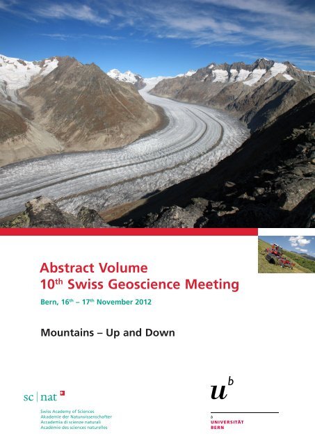
Large picture: View of the Aletsch Glacier from Bettmerhorn (Picture: Pierre Dèzes, SCNAT)<br />
Small picture: An Aebi Terratrac TT 205 working in steep terrain (Picture: Aebi, Burgdorf).
10 th <strong>Swiss</strong> <strong>Geoscience</strong> <strong>Meeting</strong>,<br />
Bern 2012<br />
Table of contents<br />
Organisation 2<br />
<strong>Abstract</strong>s<br />
1 Educational research on <strong>Geoscience</strong> teaching and learning 4<br />
2 Structural Geology, Tectonics and Geodynamics 14<br />
3 Mineralogy, Petrology, Geochemistry 74<br />
4 Tracing magmatic systems from the petrological, geochemical 74<br />
and isotopic perspective (merged with symposium 3)<br />
5 Low-Temperature Isotope Geochemistry 74<br />
(merged with symposium 3)<br />
6 Geophysics and Rockphysics 130<br />
7 Stratigraphy in Switzerland - from field to application 162<br />
8 Palaeontology – in memoriam of Jean-Pierre Berger 188<br />
9 Quaternary environments: landscapes, climate, ecosystems, 214<br />
human activity during the past 2.6 million years<br />
10 Geomorphology 236<br />
11 Cryospheric Sciences 264<br />
12 Advances in applied hydrology and limnology. 298<br />
13 Limnogeology and the interdisciplinary study of lacustrine 314<br />
sediments: Crystalizing F.-A. Forel vision.<br />
14 Environmental Biogeosciences 338<br />
15 Biogeochemical cycles in a changing environment 368<br />
16 Seasons and phenology in mountain regions 380<br />
(merged with symposium 17)<br />
17 Alpine Meteorology 380<br />
18 Greenhouse Gases: Linkages between biosphere and climate 404<br />
(merged with symposium 15)<br />
19 <strong>Geoscience</strong> and Geoinformation - From data acquisition 412<br />
to modelling and visualisation<br />
20 Earth System Science related Earth Observation 434<br />
21 Landscape and its meanings for society 444<br />
22 Symposium in human geography 460<br />
http://geoscience-meeting.scnatweb.ch
2<br />
Organization<br />
Organisation<br />
Host Institutions<br />
Institute of Geography of the University of Bern<br />
Institute of Geological Sciences of the University of Bern<br />
Patronnage<br />
Platform <strong>Geoscience</strong>s, <strong>Swiss</strong> Academy of Sciences<br />
Program Committee<br />
Daniel Ariztegui<br />
Rizlan Bernier-Latmani<br />
Gilles Borel<br />
Pierre Dèzes<br />
Hans-Rudolf Egli<br />
Werner Eugster<br />
Charles Fierz<br />
Karl Föllmi<br />
Isabelle Gärtner-Roer<br />
Alain Geiger<br />
Irka Hajdas<br />
<strong>Swiss</strong> <strong>Geoscience</strong> <strong>Meeting</strong> 2012<br />
Chris Heinrich<br />
Tobias Jonas<br />
Margreth Keiler<br />
Christian Klug<br />
Klaus Mezger<br />
Thomas Nägler<br />
Nils Oesterling<br />
Jasquelin Pena<br />
Thomas Pettke<br />
Adrian Pfiffner<br />
Eric Reusser<br />
Local Organizing Committee<br />
Stefan Brönnimann<br />
Céline Dizerens<br />
Hans-Rudolf Egli<br />
Margreth Keiler<br />
Klaus Mezger<br />
Thomas Pettke<br />
Bruno Schädler<br />
Rolf Weingartner<br />
Elias Samankassou<br />
Bruno Schädler<br />
Michael Schaepman<br />
Thomas Scheurer<br />
Guido Schreurs<br />
Jürg Schweizer<br />
Dea Voegelin<br />
Helmut Weissert<br />
Adrian Wiget<br />
Saskia Willemse<br />
Wolfgang Wilcke<br />
Stefan Wunderle<br />
Platform <strong>Geoscience</strong>s, <strong>Swiss</strong> Academy of Science, SCNAT
Participating Societies and Organisations<br />
Association for Geographical Education Switzerland (VGD-CH/AGD-CH)<br />
Federal Office of Meteorology and Climatology (Meteo<strong>Swiss</strong>)<br />
Federal Office of Topography (swisstopo)<br />
Forum for Climate and Global Change (ProClim–)<br />
International Geosphere-Biosphere Programme, <strong>Swiss</strong> Committee (IGBP)<br />
International Union of Geodesy and Geophysics, <strong>Swiss</strong> Committee (IUGG)<br />
International Union of Geological Sciences, <strong>Swiss</strong> Committee (IUGS)<br />
Kommission der Schweizerischen Paläontologischen Abhandlungen (KSPA)<br />
Naturhistorisches Museum der Burgergemeinde Bern<br />
<strong>Swiss</strong> Association of Geologists (CHGEOL)<br />
<strong>Swiss</strong> Commission on Atmospheric Chemistry and Physics (ACP)<br />
<strong>Swiss</strong> Commission for Oceanography and Limnology (COL)<br />
<strong>Swiss</strong> Commission for Phenology and Seasonality (CPS)<br />
<strong>Swiss</strong> Commission for Remote Sensing (SCRS)<br />
<strong>Swiss</strong> Geodetic Commission (SGC)<br />
<strong>Swiss</strong> Geological Society (SGG/SGS)<br />
<strong>Swiss</strong> Geological Survey (swisstopo)<br />
<strong>Swiss</strong> Geomorphological Society (SGGm/SSGm)<br />
<strong>Swiss</strong> Geophysical Commission (SGPK)<br />
<strong>Swiss</strong> Geotechnical Commission (SGTK)<br />
<strong>Swiss</strong> Hydrogeological Society (SGH)<br />
<strong>Swiss</strong> Hydrological Commission (CHy)<br />
<strong>Swiss</strong> Meteorological Society (SGM)<br />
<strong>Swiss</strong> Paleontological Society (SPG/SPS)<br />
<strong>Swiss</strong> Snow, Ice and Permafrost Society (SIP)<br />
<strong>Swiss</strong> Society for Hydrology and Limnology (SGHL / SSHL)<br />
<strong>Swiss</strong> Society for Quaternary Research (CH-QUAT)<br />
<strong>Swiss</strong> Society of Mineralogy Petrography (SMPG / SSMP)<br />
<strong>Swiss</strong> Tectonics Studies Group (<strong>Swiss</strong> Geologiocal Society)<br />
Verband Geographie Schweiz (ASG)<br />
Platform <strong>Geoscience</strong>s, <strong>Swiss</strong> Academy of Science, SCNAT <strong>Swiss</strong> <strong>Geoscience</strong> <strong>Meeting</strong> 2012<br />
3<br />
Organization
4<br />
Symposium 1: Educational Research on <strong>Geoscience</strong> Teaching and Learning<br />
1. Educational Research on <strong>Geoscience</strong> Teaching<br />
and Learning<br />
TALKS:<br />
Sibylle Reinfried, Armin Rempfler & Marco Adamina<br />
Association for Geographical Education Switzerland (VGD-CH)<br />
Verband Geographie Schweiz (ASG)<br />
1.1 Rempfler A.: Systems thinking – the key concept for geoscience teaching and learning. Avalanche training as a<br />
way of promoting it.<br />
1.2 Adamina M.: Kompetenzen und Kompetenzentwicklungen von Schülerinnen und Schülern zur räumlichen<br />
Orientierung in der Primarstufe<br />
1.3 Heer A. J.: Practical teaching of geography at high school level - experiences from own teaching practice.<br />
1.4 Reinfried S., Tempelmann S.: Exploring secondary school students’ conceptual understanding of hillslope springs<br />
through learning process analyses<br />
POSTERS:<br />
P 1.1 Sauron A., Haslinger F.: Seismo at School – introducing seismology to the classroom in Switzerland<br />
P 1.2 Madonna E.: Fehlvorstellungen zum Thema Jahreszeiten und deren Änderungen durch den Unterricht<br />
<strong>Swiss</strong> <strong>Geoscience</strong> <strong>Meeting</strong> 2012<br />
Platform <strong>Geoscience</strong>s, <strong>Swiss</strong> Academy of Science, SCNAT
1.1<br />
Systems thinking – the key concept for geoscience teaching and<br />
learning. Avalanche training as a way of promoting it.<br />
Rempfler Armin +<br />
+ Department for Teaching and Learning, University of Teacher Education Central Switzerland Lucerne, Töpferstrasse 10, CH-6004 Lucerne<br />
(armin.rempfler@phz.ch)<br />
Following the state-of-the-art of different geoscience disciplines the “Educational Standards in Geography for the<br />
Intermediate School Certificate” (DGfG 2012) proclaim the systems concept as the fundamental concept of geography<br />
education (Fig. 1). According to the current state of knowledge, systems thinking (or more comprehensively, system competence)<br />
refers to the ability to recognise a complex segment of reality in its organisation and its behaviour as a system,<br />
and to act accordingly in a manner adequate for the system.<br />
Snow avalanches are met with great interest among the population of Switzerland, since snow sport activities are very<br />
popular. However, there is also a tragic aspect, because most of the 25 avalanche victims per year are the ones who cause<br />
the (slab) avalanches in which they lose their lives. What makes dealing with avalanches so difficult is the fact that they<br />
exhibit numerous characteristics of dynamic systems such as openness, non-linearity, emergence, self-organised criticality,<br />
and limited predictability. But in contrast to comparable phenomena such as earthquakes, one individual can interact<br />
directly, especially in case of slab avalanches. While this circumstance makes avalanches dangerous, it also makes them<br />
particularly interesting for researching systems thinking.<br />
Within the scope of a quasi-experimental study, including pre- and post-tests, the demand for the construction of a learning<br />
environment in order to effectively improve the competence of systems thinking about the topic of avalanches was<br />
the central goal. Therefore a teaching unit on the topic of avalanches, consisting of eight lessons, was initially developed<br />
as an intervention tool. Examples of such approaches introduced in greater detail in the presentation include an avalanche<br />
experiment (with everyday materials such as flour and salt) and a computer programme for simulating avalanches<br />
(Harvey 2006). A total of 555 students (13- to 14-year-old) in 30 classes participated, with 4 classes serving as the control<br />
group. A standardised questionnaire was used to collect variables such as subject knowledge and everyday ideas of avalanches<br />
as well as system competence for the topic of avalanches. The tool to measure the subject knowledge and everyday<br />
ideas was taken and adapted from a pilot study (Rempfler 2010a, b). To operationalise system competence (i.e. ‘system<br />
organisation’ and ‘system behaviour’), we followed a structural model which was derived from empirical studies and<br />
theoretical-conceptual works (Rempfler & Uphues 2011).<br />
The results show that the everyday ideas of avalanches (mental models) immediately after the treatment are highly significant<br />
more differentiated than at time T1 and that this level remains high even after 6 to 8 weeks. In comparison, the<br />
control group shows no change or even a negative change. The trend for the system competence (and subject knowledge)<br />
of the students is similar, although somewhat less distinct. A multi-level analysis indicates that the mental models for<br />
‘system organisation’ act as a predictor: students with more sophisticated mental models at time T2 achieved significantly<br />
higher ‘system organisation’ values than students with poorly differentiated mental models. Based on these results the<br />
question what elements of the intervention tool could have made a material contribution to changing the mental models<br />
and system competence will be discussed. Related and more fundamentally, the question arises what general conclusions<br />
for effectively promoting systems thinking can be derived.<br />
REFERENCES<br />
DGfG – German Geographical Society Ed. 2012: Educational Standards in Geography for the Intermediate School<br />
Certificate, Bonn.<br />
Harvey, S. 2006: White Risk. Interaktive Lern-CD zur Lawinenunfall-Prävention, Davos.<br />
Rempfler, A. 2010a: Systems Concepts of Youths: Design and Results of an Explorative Pilot Study on the Topic of<br />
Avalanches. DIE ERDE 141/4, 341-359.<br />
Rempfler, A. 2010b: Fachliche und systemische Alltagsvorstellungen von Schülerinnen und Schülern zum Thema<br />
Lawinen. In Reinfried, S. Ed.: Schülervorstellungen und geographisches Lernen. Berlin: 55-85.<br />
Rempfler, A. & Uphues, R. 2011: System Competence in Geography Education. Development of competence models, diagnosing<br />
pupils’ achievement. European Journal of Geography 3/1, 6-22.<br />
<strong>Swiss</strong> <strong>Geoscience</strong> <strong>Meeting</strong> 2012<br />
Platform <strong>Geoscience</strong>s, <strong>Swiss</strong> Academy of Science, SCNAT<br />
5<br />
Symposium 1: Educational Research on <strong>Geoscience</strong> Teaching and Learning
6<br />
Symposium 1: Educational Research on <strong>Geoscience</strong> Teaching and Learning<br />
Figure 1. The human-environment system – basic concept in the analysis of space in geography education (DGfG, 2012, 12)<br />
<strong>Swiss</strong> <strong>Geoscience</strong> <strong>Meeting</strong> 2012<br />
Platform <strong>Geoscience</strong>s, <strong>Swiss</strong> Academy of Science, SCNAT
1.2<br />
Kompetenzen und Kompetenzentwicklungen von Schülerinnen und<br />
Schülern zur räumlichen Orientierung in der Primarstufe<br />
Adamina Marco<br />
PHBern, Institut für Forschung, Entwicklung und Evaluation, Fabrikstrasse 2, CH-3012 Bern<br />
Die stärkere Ausrichtung des Lernens auf die Förderung von Kompetenzen (Kompetenzorientierung in der Lehr- und<br />
Lernplanung und in der Unterrichtsentwicklung), die Einführung von Standards und damit verbunden auch eine veränderte<br />
Aufgaben- und Beurteilungskultur bedeuten für die fachdidaktische Forschung neue Herausforderungen. Dazu gehören<br />
die Kompetenzmodellierung und –diagnostik, Fragen zu Vorwissen und –können und zu Kompetenzentwicklungen<br />
der Lernenden sowie entsprechende Assessments.<br />
Während zum Beispiel im Bereich der Mathematik und der Naturwissenschaften bereits über einen längeren Zeitraum -<br />
insbesondere im Anschluss an die Ergebnisse der TIMSS- und PISA-Untersuchungen - Forschungen und Entwicklungsarbeiten<br />
durchgeführt wurden und werden, besteht im Bereich der Geographiedidaktik und dabei insbesondere auch zum raum-<br />
und geographiebezogenen Lernen in der Primarstufe ein Mangel an Grundlagenarbeit und an Untersuchungen.<br />
Im Projekt stehen Fragen der Kompetenzmodellierung, der Entwicklung von Kompetenzen und dabei auch der<br />
Unterschiedlichkeit von Entwicklungsverläufen von Lernenden zur räumlichen Orientierung in der Primarstufe im<br />
Vordergrund.<br />
In der explorativ angelegten Studie werden, basierend auf einer theoretisch abgestützten Kompetenzmodellierung, eine<br />
Querschnitt- und eine Längsschnittuntersuchung zur Ausprägung und Entwicklung von Kompetenzen zur räumlichen<br />
Orientierung und zu räumlichen Vorstellungen von Schülerinnen und Schülern in der Primarstufe (3.-6. Schuljahr) durchgeführt.<br />
Es wird untersucht, welche Aspekte in welcher Form Einfluss auf die Kompetenzentwicklung haben. Zudem<br />
werden Fragen der Methodik und der Instrumentenentwicklung für die Erschliessung und Erhebung von<br />
Kompetenzentwicklungen bei jüngeren Schülerinnen und Schülern aufgenommen und entsprechende Verfahren erprobt.<br />
Dazu wurden Testsituationen und -aufgaben entwickelt, getestet und nach einer weiteren Überarbeitung in sieben Klassen<br />
am Ende des 4. Schuljahres (n 142) und in sechs Klassen des 6. Schuljahres (n 122) im Rahmen der Querschnittuntersuchung<br />
eingesetzt. Parallel dazu wurden in einem Fragebogen Aspekte der schulischen und ausserschulischen Erfahrungen, des<br />
Interesses, der Selbsteinschätzung u.a. der Lernenden erhoben und ein Test zu Aufgaben zum räumlichen Denken und zur<br />
räumlichen Orientierung (aus dem Bereich Form und Raum in der Mathematik) durchgeführt. Die Erhebungen erfolgten<br />
im Rahmen von insgesamt fünf Unterrichtssequenzen à 2 Lektionen an den jeweiligen Schulen. Eine Sequenz wurde in<br />
Kleingruppen im Realraum absolviert.<br />
Mit dem gleichen Setting – allerdings mit einer Erhebungssequenz weniger - wurde die Längsschnittuntersuchung im<br />
Sommer/Herbst in 9 Klassen des 3. Schuljahres (n 189) begonnen (Zeitpunkt 1 Anfang des 3. Schuljahres, gleichzeitig auch<br />
Querschnittuntersuchung 3.-6. Schuljahr 2011, Zeitpunkt 2 Ende des 4. Schuljahres im Frühling/Sommer 2013 und 3.<br />
Zeitpunkt Ende des 6. Schuljahres im Frühling/Sommer 2015)<br />
Auf der Grundlage der ersten Auswertungsarbeiten wurden 39 Schülerinnen und Schüler der Klassen im Längsschnitt für<br />
ein fokussierendes Interview ausgewählt. Ziel dieser vertiefenden Erhebung ist es, noch näher an den Lernenden ergänzende<br />
Angaben, Aussagen und Kommentare zu erschliessen zur Kompetenzentwicklung, zu den Einflussfaktoren und zu<br />
den Rahmenbedingungen, welche die Ausprägung und Entwicklung von Kompetenzen beeinflussen. Die Interviews wurden<br />
im Februar/März 2012 geführt und werden momentan ausgewertet.<br />
Bis im Spätherbst 2012 liegen erste Ergebnisse aus der Querschnittuntersuchung vor, welche Aussagen zu<br />
Kompetenzausprägungen insgesamt, zu Unterschieden zwischen den Ausprägungen bei einzelnen Schülerinnen und<br />
Schülern, Klassen und Schulstufen erlauben. Auf dieser Grundlage ist es auch möglich, eine erste Validierung der<br />
Kompetenzmodellierung und -erfassung (Struktur- und Entwicklungsmodell) im Bereich der räumlichen Orientierung auf<br />
der Primarstufe vorzunehmen. Die Ergebnisse dienen insbesondere auch dazu, Fragen und Aspekte der Kompetenzdiagnostik<br />
und -förderung im Hinblick auf die Unterrichtsentwicklung zu erörtern.<br />
Im Vortrag werden insbesondere Fragen der Kompetenzmodellierung, methodologische Aspekte des Untersuchungsdesigns<br />
vorgestellt und zur Diskussion unterbreitet.<br />
Zudem werden erste Ergebnisse aus der Querschnittuntersuchung dargelegt und Fragen dazu erörtert.<br />
Schlagwörter: Kompetenzmodellierung, Kompetenzerwartungen, -ausprägungen, -entwicklungen; raum- und geographiebezogenes Lernen,<br />
räumliche Orientierung, Längsschnittuntersuchung Primarstufe<br />
<strong>Swiss</strong> <strong>Geoscience</strong> <strong>Meeting</strong> 2012<br />
Platform <strong>Geoscience</strong>s, <strong>Swiss</strong> Academy of Science, SCNAT<br />
7<br />
Symposium 1: Educational Research on <strong>Geoscience</strong> Teaching and Learning
8<br />
Symposium 1: Educational Research on <strong>Geoscience</strong> Teaching and Learning<br />
1.3<br />
Practical teaching of geography at high school level - experiences from<br />
own teaching practice.<br />
Heer Aleksandra Joanna +<br />
+ Institute of Geography, University of Bern, Hallerstrasse 12, CH-3012 Bern (heer@giub.unibe.ch)<br />
Starting a high school geography class, one faces various levels of students’ previous knowledge and their ideas about what<br />
geography is and how it should be taught are no less variable. Initial developing of common basics would be time consuming<br />
and an important ingredient of the geographical competence would be missing anyway: the sense of geographical<br />
processes carrying on around. Aiming at developing just this very specific ability of sensing complex natural and social<br />
processes in the geographical space, I often use the vehicle of the applied geosciences and foster students’ practical contribution<br />
to the lessons. This being aware that far less geographic scientific theory may be imparted to the students, but<br />
based on repeated experience, that sustainable interest on geoscientific topics may be supported this way.<br />
Two projects, selected from among the topics of physical geography and realised in 2000-2012 during my teaching contract<br />
at the Atelierschule in Zürich, are presented in following. All photos and figures are originally made by the students or<br />
by me. Both projects include extended field trips completing thematically the teaching in the classroom.<br />
Geology project with a field trip of two days.<br />
The geology may be a topic in the “Quarta”, the starting gymnasium class. The initial instruction takes ca. two weeks’<br />
time in the classroom (15 lessons a week) and includes a) elements of geology and geomorphology of the region where the<br />
school is located, b) sedimentary processes and the construction of rocks, c) geotectonics, development of oceans and<br />
mountains, petrology, d) influence of geological processes on human societies, e.g. volcanoes, earthquakes, or selected<br />
deposits, e) field trip illustrating geotectonic processes and landscape evolution in a selected region. The last field trip,<br />
which will be reported here, was carried out in the Albulapass area.<br />
Interdisciplinary project in surveying and mapping, in collaboration with mathematics.<br />
Surveying is usually carried out on demand of a local authority, so the students know that their project is useful and will<br />
contribute to sustainable development of a municipality. It takes usually 1.5 weeks of fieldwork with surveying devises<br />
and final construction of a map. Following a student’s report from such a project:<br />
„Die Vermessung der Doline<br />
Die Doline liegt oberhalb des Lai da Palpuogna am Hang zwischen zwei Geröllhalden. Das Wasser hat unter der Erde im Kalkgestein eine<br />
Höhle ausgewaschen bis die Decke der Höhle so dünn wurde, dass sie einstürzte und die Doline bildete.<br />
Wir hatten die Aufgabe, die Doline zu vermessen. Um die Grösse der Doline zu bestimmen, steckten wir ein Polygon um sie herum ab. So<br />
konnten wir mit dem Theodolit die Winkel des Polygons und den Rand der Doline bestimmen. Mit dem Nivelliergerät massen wir die<br />
Steigung des Hanges. Das steile, schwierige Gelände erschwerte uns die Arbeit beträchtlich.<br />
Um die Tiefe der Doline zu bestimmen, spannten wir ein Seil von oben bis unten. An diesem befestigten wir alle vier Meter eine Senkrecht<br />
hängende Schnur. Diese schnitten wir direkt über dem Boden ab. Die Schnüre wurden ausgemessen und mit diesen Massen konnten wir ein<br />
Höhenprofil zeichnen. Dasselbe machten wir für ein Querprofil. Aus diesen Profilen konnten wir die tiefste Stelle in der Doline errechnen.<br />
Unsere genaue Vermessung wird in Zukunft sehr wichtig sein, um festzustellen, ob sich der Boden noch weiter bewegt. Der Albula-Tunnel<br />
ist sehr sanierungsbedürftig und um ihn während der Sanierungszeit nicht schliessen zu müssen steht die Frage, einen zweiten Tunnel zu<br />
bauen. Um aber bohren zu können, ohne dass die Doline weiter einstürzt (oder der See ausläuft), muss beobachtet werden können, ob sich<br />
die Doline bewegt.<br />
Trotz des Regens und mit der Hilfe von Frau Heer konnten wir die Vermessung genau und ordentlich zu Ende bringen. Unsere Gruppe<br />
war motiviert und ehrgeizig. Es war uns ein Trost, zu wissen, dass wir nicht ohne guten Grund in Kälte und Nässe ausgeharrt haben um<br />
zu vermessen.“<br />
<strong>Swiss</strong> <strong>Geoscience</strong> <strong>Meeting</strong> 2012<br />
Platform <strong>Geoscience</strong>s, <strong>Swiss</strong> Academy of Science, SCNAT
Fig. 1 Zusammenfassung der Vermessung der Doline SW‘ Lai da Palpuogna. Monitoring Punkte (L1, N, J, K, D, Q , T, O, P, R und S) sind<br />
eingemessen und dienen der Beobachtung von Hangbewegungen.<br />
<strong>Swiss</strong> <strong>Geoscience</strong> <strong>Meeting</strong> 2012<br />
Platform <strong>Geoscience</strong>s, <strong>Swiss</strong> Academy of Science, SCNAT<br />
9<br />
Symposium 1: Educational Research on <strong>Geoscience</strong> Teaching and Learning
10<br />
Symposium 1: Educational Research on <strong>Geoscience</strong> Teaching and Learning<br />
1.4<br />
Exploring secondary school students’ conceptual understanding of hillslope<br />
springs through learning process analyses<br />
Reinfried, Sibylle + , Tempelmann, Sebastian +<br />
+ University of Teacher Education Central Switzerland Lucerne, Department of Teaching and Learning, Töpferstr. 10, CH-6004 Lucerne,<br />
(sibylle.reinfried@phz.ch)<br />
The relevance of teaching hydrological concepts in compulsory education is given by the fact that it has become a sociopolitical<br />
and future-orientated necessity to constitute an understanding of “water knowledge” (UNESCO-IHE, 2007).<br />
However, prior research has indicated that students of all ages show little understanding of hydrological processes (e.g.<br />
Reinfried, 2006). To better understand students’ learning processes concerning hydrological issues and the difficulties<br />
related to them an analysis of 13-year old lower secondary school students’ learning pathways when trying to understand<br />
the concept of hillslope springs and spring water pollution was conducted. Freshwater springs play an important role in<br />
the context of “water knowledge” because they are at the intersection of subsurface and surface water.<br />
To better understand students’ learning processes an explanatory in-depth investigation based on the case study method<br />
was employed (Reinfried et al., 2012). Based on the principles of constructivist learning theory and conceptual change<br />
theory (e.g. Vosniadou, 2008) we developed a learning environment aimed at deep understanding and mental model building<br />
of the hillslope spring concept. To better understand (1) how students construct their knowledge and (2) what their<br />
difficulties are in understanding the complex concept of hillslope springs, we subsequently conducted a learning process<br />
study in which we explored students’ learning pathways when studying with our constructivist learning environment. The<br />
following research questions were addressed:<br />
• In which way do lower secondary school students construct their mental models of hillslope springs when learning<br />
with our learning environment?<br />
• Does in-depth learning and conceptual change occur and on what does it depend?<br />
• What role does the pre-instructional knowledge play in the students’ mental model building process?<br />
Ten students of the 7 th grade (M age = 12.4 years, 5 boys, 5 girls) from a <strong>Swiss</strong> suburban middle school were selected for the<br />
analysis of their learning pathways. The study employed an instructional sequence embedded in a pre-/post-test design,<br />
providing quantitative and qualitative data. The students’ knowledge and mental models of hillslope springs before and<br />
after the instruction were explored using a questionnaire that included 30 knowledge questions and a request to draw an<br />
annotated sketch of how they understand freshwater springs. During an instructional session, which took 60 minutes, two<br />
students, working in pairs, were guided through the learning process by a tutor. The students worked with worksheets,<br />
experiments and two physical models of freshwater springs. After the instructional session they were questioned about<br />
their learning difficulties in a one-on-one tutoring interview with each learner. The entire session was videotaped. The<br />
transcripts of the videotaped instructional session, students’ annotated drawings, their answers to the questions in the<br />
questionnaires and the transcripts of the interviews served as database. Following the different steps of qualitative content<br />
analysis (Mayring, 2008), the video and interview transcripts, the drawings and texts were interpreted, systematically categorized,<br />
generalized and contrasted.<br />
The synopsis of the data allowed an analysis of each student’s learning process in relation to his or her pre-instructional<br />
knowledge. The analysis of the learning pathways showed that the pre-instructional knowledge had the most significant<br />
influence on mental model building and conceptual change. Students’ who had no or only little prior knowledge about<br />
freshwater springs and who could only resort to general naïve ideas constructed new mental models that were very similar<br />
to the scientific model used in the learning environment. Their conceptual change concerned the change or adaption<br />
of their pre-instructional cognitive schemata. Students who showed elaborated but false mental models that were based<br />
on personal experiences with freshwater springs showed great difficulties in changing their personal mental models and<br />
adapting them to the scientific model. Apparently, their initial but false mental models, constructed through real world<br />
experience in social contexts and thus emotionally charged offered a greater subjective plausibility to them than did our<br />
teaching materials.<br />
<strong>Swiss</strong> <strong>Geoscience</strong> <strong>Meeting</strong> 2012<br />
Platform <strong>Geoscience</strong>s, <strong>Swiss</strong> Academy of Science, SCNAT
The results of this study are of great significance for instructors on all levels. Even if an appropriate, theory-based and<br />
effective learning environment is available to teach a certain topic, teaching for deep understanding involves:<br />
1. analysing students’ conceptions developed both before, during and after instruction using formative assessments,<br />
2. finding and coordinating analogies and dissonance producing events that take the students’ alternative conceptions<br />
into account and<br />
3. integrating metacognitive sequences in the lessons in which the students’ explain how they understand the topic<br />
in question and reflect about similarities and differences between their personal mental models and the scientific<br />
model. If instructors learn how to make use of mental model evolution strategies, their teaching for meaningful<br />
conceptual change will be more effective.<br />
REFERENCES<br />
Mayring, P. 2008: Qualitative Inhaltsanalyse. Weinheim: Beltz Pädagogik.<br />
Reinfried, S. (2006). Conceptual Change in Physical Geography and Environmental Sciences through Mental Model<br />
Building: The Example of Groundwater, International Research in Geographical and Environmental Education, 15 (1),<br />
41-61<br />
Reinfried, S., Tempelmann, S. & Aeschbacher, U. 2012: Addressing secondary school students’ everyday ideas about<br />
freshwater springs in order to develop an instructional tool to promote conceptual reconstruction. Hydrology and<br />
Earth System Science, 16, 1365-1377.<br />
Vosniadou, S. (Ed.) 2008: International Handbook of Research on Conceptual. New York: Routledge.<br />
UNESCO-IHE 2007: Water for a Changing World - Enhancing Local Knowledge and Capacity. www.unesco-ihe.org/<br />
About/50-years-of-wise-water/Water-for-a-Changing-World-Enhancing-Local-Knowledge-and-Capacity (last access: 11<br />
March, 2012).<br />
<strong>Swiss</strong> <strong>Geoscience</strong> <strong>Meeting</strong> 2012<br />
Platform <strong>Geoscience</strong>s, <strong>Swiss</strong> Academy of Science, SCNAT<br />
11<br />
Symposium 1: Educational Research on <strong>Geoscience</strong> Teaching and Learning
12<br />
Symposium 1: Educational Research on <strong>Geoscience</strong> Teaching and Learning<br />
P 1.1<br />
Seismo at School – introducing seismology to the classroom in Switzerland<br />
Sauron Anne + , Haslinger Florian +<br />
+ <strong>Swiss</strong> Seismological Service SED at the ETH Zürich, 8082 Zürich<br />
(anne@sed.ethz.ch)<br />
“Seismo at School” (www.seismoatschool.ethz.ch) is an educational program that aims to promote awareness of earthquake<br />
hazard and risk, and at the same time develops and provides material to use topics from earthquake science in school<br />
education, in a close collaboration between scientists and teachers.<br />
As one part of the project, seismic stations are installed at schools and used to record real-time seismic activity. These<br />
stations meet, to a large extent, the technical standards of the national seismological monitoring networks operated by<br />
the <strong>Swiss</strong> Seismological Service (SED). Earthquake databases for classroom use are generated by compounding event data<br />
recorded at the school stations with data from broadband stations of the national network, and, for large global events,<br />
also with data from global scientific and school seismic networks. The installation of seismic stations in schools, and<br />
further operation of the stations by the schools, requires dedicated involvement and training of teachers. This is achieved<br />
by working directly with the involved teachers at schools in the form of workshops, and by offering seminar days at ETH<br />
Zurich in collaboration with the focusTerra earth science information center (www.focusterra.ethz.ch).<br />
As a second part of the project, educational materials and concepts are developed in close collaboration with involved<br />
teachers, which can be used by all schools, irrespectively of whether they host a seismic station.<br />
The rich collection of earthquake data together with tools & software for data analysis, online courses, movies, bibliographies,<br />
and the various educational materials are openly available on a web platform, thus creating a extensive resource<br />
center for educational activities.<br />
Having been launched in 2010, the Seismo at School network today involves eight schools with their own seismic station,<br />
with the aim of installing a total of 26 stations in as many schools over the next years.<br />
Seismo at School is also integrated in European and global school seismology activities and actively engages in collaborations<br />
to develop new materials, exchange data, and to foster connections among participating schools.<br />
The Seismo at School project is partially sponsored by the <strong>Swiss</strong> Federal Office of the Environment (BAFU).<br />
<strong>Swiss</strong> <strong>Geoscience</strong> <strong>Meeting</strong> 2012<br />
Platform <strong>Geoscience</strong>s, <strong>Swiss</strong> Academy of Science, SCNAT
P 1.2<br />
Fehlvorstellungen zum Thema Jahreszeiten und deren Änderungen durch<br />
den Unterricht<br />
Erica Madonna +<br />
+ Institute for Atmospheric and Climate science, ETH Zürich. Universitätstrasse 16, CH- 8092 Zürich<br />
(erica.madonna@env.ethz.ch)<br />
Sommer, Winter, Frühling und Herbst sind vertraute Begriffe seit der Kindheit. Sie bezeichnen die Jahreszeiten, die das<br />
Jahr bei uns in verschiedene Perioden unterteilen. Jedoch nicht überhall auf der Erde gibt es vier Jahreszeiten. An den<br />
Polen unterscheidet man nur das Sommer- und das Winterhalbjahr; innerhalb der tropischen Zone findet man hingegen<br />
nur Trocken- und Regenzeiten.<br />
In Spontansituationen, wenn Leute die Entstehung der Jahreszeiten erklären sollen, wird häufig wie folgt argumentiert<br />
„Im Sommer ist es wärmer, weil die Erde näher an der Sonne ist“ (Alean 2009).<br />
Diese Antwort stammt aus der intuitiven Überlegung, dass die Wärme zunimmt je mehr man sich einer Wärmequelle<br />
nähert. Alltagsvorstellungen sind mentale Konstrukte, welche das Vorstellungsbild aus Ausschnitten der Realität zusammensetzen<br />
(Reinfried 2006). Sie werden als Fehlvorstellung bezeichnet und sie spielen eine wichtige Rolle für die<br />
Wissenserwerbung (Vosniadou et al. 2001).<br />
Im Rahmen meiner Geographielehrerausbildung habe ich das Thema von Fehlvorstellungen im Geographieuntericht am<br />
Beispiel von Jahreszeiten untersucht. Das Ziel war es eine Unterrichtstrategie zu entwickeln, die die Fehlvorstellungen<br />
zum Thema Jahreszeiten abbauen kann. Als Ausgangspunkt wurde das Vowissen der Schüler und Schülerinnen einer<br />
dritten Klasse (neuntes Schuljahr) erhoben. Basierend auf der 4-Phasen Strategie von S. Reinfried (Reinfried, 2006) zum<br />
Aufbau von mentalen Modellen im geowissenschaftlichen Unterricht wurde anschliessend eine Unterrichtseinheit geplant<br />
REFERENCES<br />
Alean, J. 2009 : Unterrichtsmaterialien im Umfeld der Sekundarstufe: Entstehung der Jahreszeiten. <strong>Swiss</strong>educ.<br />
Reinfried, S 2006: Alltagsvorstellungen – und wie man sie verändern kann: Das Beispiel Grundwasser. Geographie Heute<br />
243, 38-43.<br />
Vosniadou, S., Innides, C., Dimitrakopoulou, A. and Papadementriou, E. 2001: Designing learning environments to<br />
promote conceptual change in science. Learning and Instruction 11, 381-419.<br />
<strong>Swiss</strong> <strong>Geoscience</strong> <strong>Meeting</strong> 2012<br />
Platform <strong>Geoscience</strong>s, <strong>Swiss</strong> Academy of Science, SCNAT<br />
13<br />
Symposium 1: Educational Research on <strong>Geoscience</strong> Teaching and Learning
14<br />
Symposium 2: Structural Geology, Tectonics and Geodynamics<br />
2. Structural Geology, Tectonics and Geodynamics<br />
TALKS:<br />
Neil Mancktelow, Guido Schreurs, Paul Tackley<br />
<strong>Swiss</strong> Tectonics Studies Group of the <strong>Swiss</strong> Geological Society<br />
2.1 Bauville, A., Schmalholz, S.: Thermo-mechanical model for the finite strain distribution in kilometer-scale<br />
shear zonez<br />
2.2 Beltrán-Triviño, A., Einkler, W., Bussien, D., von Quadt, A.: Early Mesozoic rift-related sandstones of the<br />
Southern Alpine Tethys margin characterised by detrital zircons: U-Pb dating and Hf-isotopes analysis<br />
2.3 Ben Slama, M., Ghanmi, M., Ben Youssef, M., Zargouni, F.: Early Cretaceous Triassic salt extrusion rates at Jebel<br />
Ech Cheid (N. Tunisia, southern Tethyan passive marge)<br />
2.4 Cardello, G.L., Mancktelow, N.S.: Oblique normal faulting in carbonates at different crustal levels: examples<br />
from the SW Helvetics and Central Apennines<br />
2.5 Fischer, R.: Self-consistent modelling of planetary differentiation and onset of mantle convection on Mars. A<br />
comparative study in 2D and 3D<br />
2.6 Frehner, M., Reif, D., Grasemann, B.: Mechanical versus kinematical shortening reconstructions of the Zagros<br />
High Folded Zone (Kurdistan Region of Iraq)<br />
2.7 Gerya, T.: Tectono-magmatic crustal convection produces novae and coronae on Venus<br />
2.8 Gonzalez, L., Pfiffner, O.A.: Structure and evolution of the Central Andes of Peru<br />
2.9 Heuberger, S., Naef, H.: The St.Gallen Fault Zone (NE Switzerland): A long-lived, multiphase structure in the<br />
North Alpine Foreland - Insights from high-resolution 3D seismic data<br />
2.10 Madritsch, H., Birkhäuser, P., Heuberger, S., Malz, A., Meier, B., Schnellmann, M.: Thin- vs. Thick-skinned<br />
tectonics in the Alpine foreland of central northern Switzerland: New perspectives based on reprocessed and new<br />
reflection seismic data<br />
2.11 Robyr, M., Banerjee, S., El Korh, A.: New time-constraints on the prograde metamorphism in the High Himalaya<br />
of NW Lahul (NW India)<br />
2.12 Ruh, J., Gerya, T., Burg, J.-P.: Towards 4D modeling of transpressional fold-and-thrust belts<br />
2.13 Sala, P., Pfiffner, O.A., Frehner, M.: Alpine fold and thrust structures: a 3-D model of the Säntis area<br />
(Switzerland)<br />
2.14 Scheiber, T., Pfiffner, O.A., Schreurs, G.: The nature of the “Frilihorn nappe” (Valais, Switzerland)<br />
2.15 Schmid, S.M., Scharf, A., Handy, M.R., Rosenberg, C.L.: The Tauern Window (Eastern Alps, Austria) – A new<br />
tectonic map, cross-sections and tectonometamorphic synthesis<br />
2.16 Ueda, K., Willett, S., Gerya, T.: Coupling of landscape evolution and rheologically layered thermomechanical<br />
models in three dimensions<br />
2.17 Villiger, A., Geiger, A., Marti, U., Brockmann, E., Schlatter, A.: <strong>Swiss</strong> 4D: Determination of strain rates from GNSS<br />
campaign and levelling data<br />
2.18 Wehrens, P., Baumberger, R., Herwegh, M.: Deformational evolution of the Aar Massif (Central Alps): From<br />
macro- to micro-scale<br />
2.19 Zhu, G., Gerya, T., Tackley, P., Kissling, E.: 4-D Numerical Modeling of Crustal Growth at Active Continental<br />
Margins<br />
<strong>Swiss</strong> <strong>Geoscience</strong> <strong>Meeting</strong> 2012<br />
Platform <strong>Geoscience</strong>s, <strong>Swiss</strong> Academy of Science, SCNAT
POSTERS:<br />
P 2.1 Thielmann, M., Rozel, A., Kaus, B.J.P., Ricard, Y.: Dynamic recrystallization and shear heating in numerical<br />
models of lithospheric-scale shear zones<br />
P 2.2 Rolf, T., Coltice, N., Tackley, P.J.: Dynamic origin of Wilson cycles in mantle convection with self-consistent<br />
plate tectonics and continental drift<br />
P 2.3 Liao, J., Gerya, T.: 3D numerical modeling of continental extension to oceanic spreading<br />
P 2.4 Crameri, F., Tackley, P., Meilick, I., Gerya, T., Kaus, B.: Implications of single-sided subduction in global selfconsistent<br />
models of mantle convection<br />
P 2.5 Ueda, K., Gerya, T.: Exhumation of HP to UHP-HT rocks during delamination in orogenic settings -<br />
distribution of P-T paths from numerical modelling<br />
P 2.6 Golabek, G., Gerya, T., Morishima, R., Tackley, P., Labrosse, S.: Towards combined modelling of planetary<br />
accretion and differentiation<br />
P 2.7 May, D.: A 3D Marker-In-Cell Finite Element based Discretisation for Lithospheric Scale Geodynamics: Theory<br />
and Applications<br />
P 2.8 von Tscharner, M., Schmalholz, S.: 3D FEM modeling of fold nappe formation in the Western <strong>Swiss</strong> Alps<br />
P 2.9 Frehner, M., Exner, U.: Do foliation refraction patterns around buckle folds represent finite strain?<br />
P 2.10 Collignon, M., Kaus, B., Frehner, M., Fernandez, N., Castelltort, S., Simpson, G., Burg, J.-P.: Modeling<br />
interactions between tectonic and surface processes in the Zagros Mountain, Iran<br />
P 2.11 Bahiraie, S., Abbasi, M.: Kinematic Investigation of the Central Alborz Mountain belt<br />
P 2.12 Bagheri, S., Damani, G.S., Jafari, S.: Cenozoic deformation of Mount Birk: A key to restoring of Iranian<br />
Baluchestan tectonic history<br />
P 2.13 Mohammadi, A., Winkler, W., Burg, J.-P.: Sandstone detrital mode and heavy mineral study in the Makran<br />
accretionary wedge, southeast Iran: implication for the tectonic setting<br />
P 2.14 Heredia, B.D., Hilgen, F., Gaylor, J.R., Kuiper, K., Mezger, K.: The Cretaceous-Palaeogene (K/Pg) boundary:<br />
cyclostratigraphic and U-Pb zircon geochronological constraints<br />
P 2.15 Peybernes, C., Martini, R., Chablais, J.: The breccias of Sambosan Accretionary Complex (southwestern Japan):<br />
tectonic vs depositional origin<br />
P 2.16 Abdelfettah, Y., Mauri, G., Kuhn, P., Schill, E., Vuataz, F.-D.: Investigation of deep geological structures in the<br />
north-west part of Canton of Neuchatel using a combination of gravity and 3D geological model<br />
P 2.17 Arndt, D., Jordan, P., Madritsch, H.: The Born Engelberg Anticline (Eastern Jura Mountains): New insights<br />
from balanced cross sections and 3D modelling<br />
P 2.18 Malz, A., Madritsch, H., Meier, B., Heuberger, S., Navabpour, P., Kley, J.: To what extent have inherited normal<br />
faults influenced thrust propagation at the front of the easternmost Jura fold-and-thrust belt?<br />
P 2.19 Mauri, G., Negro, F., Abdelfettah, Y., Schill, E., Vuataz, F.-D.: Deep geothermal exploration of low enthalpy<br />
reservoir in the Neuchâtel Jura (GeoNE project) – Use of gravity survey to validate and improve 3D geological<br />
models.<br />
<strong>Swiss</strong> <strong>Geoscience</strong> <strong>Meeting</strong> 2012<br />
Platform <strong>Geoscience</strong>s, <strong>Swiss</strong> Academy of Science, SCNAT<br />
15<br />
Symposium 2: Structural Geology, Tectonics and Geodynamics
16<br />
Symposium 2: Structural Geology, Tectonics and Geodynamics<br />
P 2.20 Negro, F., Mauri, G., Vuataz, F.-D., Schill, E.: Exploration of deep low enthalpy geothermal reservoirs in the<br />
Neuchâtel Jura (GeoNE project) – 3D geological and thermal modeling of potential aquifers.<br />
P 2.21 Giroud,N., Vuataz., F.-D., Schill, E.: Permeable Fault Detection in Deep Geothermal Aquifer Exploration by Soil<br />
Gas Measurement<br />
P 2.22 Abedgno, M., Vouillamoz, N., Deichmann, N., Husen, S., Wust-Bloch, H.G., Mosar, J.: Cross-correlation and<br />
location error assessment of nano-earthquakes on the Fribourg Lineament - Switzerland<br />
P 2.23 Peters, M., Weber, C.: The application of titanium-in-quartz geothermometry in recrystallized quartz - a<br />
methodological discussion<br />
P 2.24 Poilvet, J.-C., Goncalves, P., Oliot, E., Marquer, D.: Role of brittle deformation and fluid-rock interaction on the<br />
formation of ductile shear zone under blueschist facies conditions<br />
P 2.25 Moulas, E., Podladchikov, Y., Vrijmoed, J., Tajcmanova, L., Simon, N., Burg, J.-P.: Transient Temperature and<br />
Pressure variations in crustal shear zones – numerical modelling using local-thermodynamic equilibrium and<br />
a conservative approach<br />
P 2.26 Moulas, E., Burg, J.-P., Kostopoulos, D., Schenker, F.: Chemical zoning and ductility of natural garnet at lower<br />
crustal conditions: An example from the Rhodope Massif<br />
P 2.27 Antić, M., Kounov, A., Trivić, B., Peytcheva, I., von Quadt, A., Gerdjikov, I.: Fission-track constraints on the<br />
thermal evolution of the Serbo-Macedonian Massif (south Serbia, southwest Bulgaria and east Macedonia)<br />
P 2.28 Schenker, F.L., Forster, M., Burg, J.-P.: The Eastern Pelagonian metamorphic core complex: insight from the<br />
40 Ar/ 39 Ar dating of white micas<br />
P 2.29 Ladeb, M.F., Zargouni, F.: Inversion tectonique d’une zone de relais extensive adjacente à un diapir salifère:<br />
terminaison orientale du J. Chambi (Atlas central tunisien).<br />
P 2.30 Egli, D., Mancktelow, N., Spikings, R.: 40 Ar/ 39 Ar dating of Alpine shear zones in the Mont Blanc area<br />
P 2.31 Pleuger, J., Mancktelow, N., Spikings, R.: Structural and 40 Ar/ 39 Ar geochronological data from different<br />
mylonite belts along the Canavese Fault<br />
P 2.32 Cavargna-Sani, M., Epard, J.-L., Bussy, F., Ulianov, A.: Basement lithostratigraphy of the Adula nappe:<br />
implications for alpine kinematics<br />
P 2.33 Ziegler, M., Loew, S., Moore, J.R.: Distribution and inferred ages of exfoliation joints in the Aar Granite<br />
(Central Alps, Switzerland)<br />
P 2.34 Almqvist, B.S.G., Misra, S.: Seismic properties and anisotropy in melt-generating metapelites<br />
P 2.35 Hetényi, G., Kissling, E., Husen, S., Clinton, J. and the AlpArray Working Group: AlpArray – the next<br />
generation seismology initiative<br />
P 2.36 Houlie, N.: Deformation of flat areas by using InSAR. Application to the Geneva (CH) and la Faute-sur-mer<br />
(FR) areas<br />
<strong>Swiss</strong> <strong>Geoscience</strong> <strong>Meeting</strong> 2012<br />
Platform <strong>Geoscience</strong>s, <strong>Swiss</strong> Academy of Science, SCNAT
2.1<br />
Thermo-mechanical model for the finite strain distribution in kilometerscale<br />
shear zones<br />
Arthur Bauville 1 , Stefan Schmalholz 1<br />
1 Institute of Geology and Paleontology, University of Lausanne, Switzerland<br />
We present a one-dimensional shear zone model which considers a power-law flow law and a temperature dependent<br />
viscosity. The analytical solution for the velocity profile across the shear zone depends on the single dimensionless parameter<br />
β. β depends on the activation energy of the applied flow law, the temperature at the base of the shear zone and<br />
the temperature difference across it. We then derive the analytical solution of the ellipticity of strain ellipses along the<br />
shear zone. We perform a systematic parameter search over 1) the rheological parameter β, 2) the mean finite strain γm<br />
of the shear zone and 3) the shear zone thickness. We thus determine the parameters that provide the best fit between<br />
sets of strain ellipses measured in natural kilometer scale shear zones and our model (Figure 1). The estimates of β from<br />
the fitting are consistent with the ones based on temperature estimates from field data and laboratory derived activation<br />
energies of crustal rocks. Our simple 1D analytical solution can predict the nonlinear distribution of finite strain across<br />
natural kilometer-scale shear zones as a function of temperature and rheological parameters. Our results for several kilometer-scale<br />
shear zones worldwide suggest that temperature increase across shear zones controls to first order the observed<br />
nonlinear increase of finite strain towards the base of the shear zone. In the lowermost tens of meters natural shear<br />
zones often exhibit a stronger increase of finite strain (often expressed by mylonitic texture) than predicted by our simple<br />
model. This deviation from our model is likely caused by processes not considered in the model, such as for example,<br />
grain-size reduction, effects of fluids or viscous shear heating.<br />
<strong>Swiss</strong> <strong>Geoscience</strong> <strong>Meeting</strong> 2012<br />
Platform <strong>Geoscience</strong>s, <strong>Swiss</strong> Academy of Science, SCNAT<br />
17<br />
Symposium 2: Structural Geology, Tectonics and Geodynamics
18<br />
Symposium 2: Structural Geology, Tectonics and Geodynamics<br />
Figure 1. Model results showing the influence of the parameter β on a) velocity, b) strain rate and c) ellipticity profiles across the shear<br />
zone. The influence of the mean finite strain γm on the finite deformation is illustrated in d). Strain ellipses have been calculated by<br />
deforming small initial circles, which have been scaled up, with the analytical velocity profile.<br />
REFERENCES<br />
Xypolias, P., Chatzaras, V., and Koukouvelas, I. K., 2007, Strain gradients in zones of ductile thrusting: Insights from the<br />
External Hellenides: Journal of Structural Geology, v. 29, p. 1522-1537.<br />
2.2<br />
Early Mesozoic rift-related sandstones of the Southern Alpine Tethys<br />
margin characterised by detrital zircons: U-Pb dating and Hf-isotopes<br />
analysis<br />
Alejandro Beltrán-Triviño 1 , Wilfried Winkler 1 , Denise Bussien 1 & Albrecht von Quadt 2<br />
1 Geologisches Institut, ETH Zentrum, Sonneggstrasse 5, CH-8092 Zürich (alejandro.beltran@erdw.ethz.ch)<br />
2 Institut für Geochemie und Petrologie, ETH Zentrum, Clausiusstrasse 25, CH-8092 Zürich<br />
Detrital zircons from Triassic and Jurassic rift-related sandstones from the southern margin of the Alpine Tethys (SMAT)<br />
were analysed in order to characterise the age of the sources and the origin of the magmas in which the zircons have<br />
crystallised. We present results from: (1) The Fuorn Formation in the Upper Austroalpine Silvretta nappe, which represents<br />
tidally influenced shallow marine deposits of Early Triassic age (e.g. Furrer et al., 2008). (2) The Middle Jurassic Saluver<br />
Fm, which is situated in the Lower Austroalpine Err nappe and represents an example of turbiditic sandstones and breccias<br />
deposited during protracted rifting along the SMAT (Finger et al., 1982). (3) Two volcaniclastic layers within the Middle<br />
Triassic (Ladinian) carbonates of the Upper Austroalpine Silvretta nappe; the lower layer is interbedded in the Prosanto Fm<br />
(called Ducan-I) and the upper one is interbedded in the Altein Fm (Ducan-II) (Furrer et al., 2008). (4) The Carnian Val Sabbia<br />
sandstone located in the South Alpine domain, which is considered a continental terrigenous-volcaniclastic sequences with<br />
palaeocurrents from the south (Crisci et al., 1984).<br />
The U-Pb zircon ages of the Fuorn Fm show a population spanning from 310 to 260 Ma with a peak at ca 292 Ma. Thus,<br />
the Fuorn Fm was mainly sourced in Permian igneous rocks and volcaniclastics, which obviously were exhumed and eroded<br />
at the SMAT during the Triassic. Schaltegger and Brack (2007) suggest that Permian magmatism and associated basin<br />
formation occurred during major post-Variscan extensional and strike-slip movements between ca 285 - 275 Ma, which is<br />
in line with our results. The calculated epsilon-Hf values of the Permian detrital zircons between +5 to -5 indicate contamination<br />
of mantellic magmas with crustal material and depict probably two different sources of similar age.<br />
U-Pb ages of detrital zircons from Saluver Fm have a dominant population from ca 320 to 250 Ma with a peak at ca 300<br />
Ma and other minor populations from 460 - 420 Ma and from 1 - 0.95 Ga. The calculated epsilon-Hf values of the eroded<br />
Variscan and late-Variscan (Permian and Carboniferous) zircons lie between -3 to +7, indicating contamination of the magma<br />
source with crustal material. The present Saluver Fm sandstone was mainly sourced in Variscan and post-Variscan<br />
magmatic and volcaniclastic rocks, whereas no Triassic magmatic rocks were exposed in the source areas.<br />
Detrital zircons from the volcaniclastic layer Ducan-I show a U-Pb age spectrum spanning from 268 to 228 Ma with a peak<br />
at ca 252 Ma. The calculated epsilon-Hf values range between -1 to +8, indicating magmas with high contribution of juvenile<br />
mantle sources with slight contamination by crustal material. The U-Pb ages of detrital zircons from the second<br />
volcaniclastic layer Ducan-II shows a range from 264 to 238 Ma with a peak at ca 247 Ma. The calculated epsilon-Hf values<br />
range between -4 to +4, which point to contamination of mantellic magmas by crustal material. The differences of the<br />
measured Hf - isotope ratios between these two volcaniclastic layers can be explained by two scenarios: (i) The two volcaniclastic<br />
layers were sourced by two different magma reservoirs; one more contaminated by crustal material sourced<br />
Ducan-II and the other one with more influence of juvenile material sourced Ducan-I. (ii) The evolution of a single source<br />
where the reservoir first was dominated by juvenile mantle material (Ducan-I) and subsequently more contaminated by<br />
crustal material (Ducan-II).<br />
<strong>Swiss</strong> <strong>Geoscience</strong> <strong>Meeting</strong> 2012<br />
Platform <strong>Geoscience</strong>s, <strong>Swiss</strong> Academy of Science, SCNAT
The U-Pb age population of detrital zircons from the Val Sabbia sandstone covers the time span from 257 to 220 Ma with<br />
a peak at ca 240 Ma. The younger age spectrum (240-220 Ma) correlates with other Ladinian and Carnian volcanic and<br />
volcaniclastic formations in the Austroalpine domain. The epsilon-Hf values (-6 to -3) suggest a mantle source highly mixed<br />
with crustal material.<br />
There are contrasting models proposed to explain the Triassic Alpine magmatism, either within an extensional environment<br />
(e.g. Crisci et al., 1984) or in a subduction-related setting (e.g. Castellarin, 1988). The results from Triassic detrital<br />
zircons corroborate the model of Crisci et al. (1984). These authors suggest the origin of the magmas through partial<br />
melting of an upper mantle, which was deeply modified during the previous Variscan orogeny. The rising melts included<br />
crustal material during early stages of rifting along the SMAT.<br />
REFERENCES<br />
Castellarin, A., Lucchini, F., Rossi, P. L. & Simboli, G. 1988: The Middle Triassic magmatic-tectonic arc development in the<br />
Southern Alps. Tectonophysics, 146, 79-89.<br />
Crisci, C. M., Ferrara, G., Mazzuoli, R. & Rossi, P. M. 1984: Geochemical and geochronological data on Triassic volcanism<br />
of the Southern Alps of Lombardy (Italy): Genetic implications. Geologische Rundschau, 73, 279-292.<br />
Finger, W., Mercolli, I., Kündig, R., Stäubli, A., de Capitani, Ch., Nievergelt, P., Peters,. T. & Trommsdorff, V.1982: Bericht<br />
über die gemeinsame Exkursion der Schweizerischen Geologischen Gesellschaft und der Schweizerischen<br />
Mineralogischen und Petrographischen Gesellschaft ins Oberengadin vom 21. bis 24. September 1981. Eclogae Geol.<br />
Helv., 75, 199-222.<br />
Furrer, H., Schaltegger, U., Ovtcharova, M. & Meister, P. 2008: U-Pb zircon age of volcaniclastic layers in Middle Triassic<br />
platform carbonates of the Austroalpine Silvretta nappe (Switzerland). <strong>Swiss</strong>. J. Geosci., 101, 595–603.<br />
Schaltegger, U. & Brack, P. (2007) Crustal-scale magmatic systems during intracontinental strike-slip tectonics: U, Pb and<br />
Hf isotopic constraints from Permian magmatic rocks of the Southern Alps. Int. J. Earth Sci., 96, 1131-1151.<br />
The project is supported by the ETH Zurich internal grant no. 04 09-1.<br />
2.3<br />
Early Cretaceous Triassic salt extrusion rates at Jebel Ech Cheid<br />
(N. Tunisia, southern Tethyan passive marge)<br />
Mohamed-Montassar BEN SLAMA 1 , Mohamed GHANMI 1 , Mohamed BEN YOUSSEF 2 , Fouad ZARGOUNI 1<br />
1 Unité de recherche Géologie structurale et Appliquée, Faculté des Sciences de Tunis, 2092 Tunis, Tunisie.<br />
2 Laboratoire Géoressources, Centre de recherches et Technologies des eaux, BP 273, 8020 Soliman, Tunisie.<br />
E-mail : mohamedmontassar.benslama@fst.rnu.tn<br />
We apply the logic of (Talbot and Jarvis, 1984) to calculate the extrusion rates and likely heights reached by Triassic salt<br />
at Jebel Ech Cheid during Barremian-Aptian, Late Aptian, Late Cenomanian and middle Turonian times (Ben Slama,<br />
2011; Ben Slama et al., 2012). The results allow us to reconstruct the movements of the Triassic salt during its Early<br />
Mesozoic history. The extrusion rate may have exceeded 55mm year-1 and the salt fountain reached higher than 600 m<br />
in the Early Cretaceous sea if its vent was then narrower than its current maximum width.<br />
REFERENCES<br />
Ben Slama, M.-M. (2011). “Mécanismes de mise en place du matériel salifère en Tunisie septentrionale : exemples du Jebel<br />
Ech Cheid et des structures voisines.” Unpubl. PhD Thesis, Tunis Univ. Tunis., URL: http://tel.archives-ouvertes.fr/tel-<br />
00626246/fr/.<br />
Ben Slama, M.-M., Ghanmi, M., Ben Youssef, M., and Zargouni, F. (2012). Early Cretaceous extrusion rates and heights of<br />
Triassic salt at Jebel Ech Cheid (NE Moghrebian Atlas, Tunisia) (submited manuscript). <strong>Swiss</strong> j. geosci.<br />
Talbot, C. J., and Jarvis, R., J. (1984). Age, budjet and dynamics of an active salt extrusion in Iran. Journal of structural<br />
geology 6, 521-533.<br />
<strong>Swiss</strong> <strong>Geoscience</strong> <strong>Meeting</strong> 2012<br />
Platform <strong>Geoscience</strong>s, <strong>Swiss</strong> Academy of Science, SCNAT<br />
19<br />
Symposium 2: Structural Geology, Tectonics and Geodynamics
20<br />
Symposium 2: Structural Geology, Tectonics and Geodynamics<br />
2.4<br />
Oblique normal faulting in carbonates at different crustal levels: examples<br />
from the SW Helvetics and Central Apennines<br />
G. Luca Cardello 1 & Neil S. Mancktelow 1<br />
1 Geological Institut, ETH-Zürich, Sonneggstrasse 5, CH-8092 Zürich (luca.cardello@erdw.ethz.ch)<br />
For the same general boundary conditions, oblique normal faults can generate crustal earthquakes of larger magnitude<br />
than those generated on dip-slip normal faults of similar size (Ranalli, 1987). In order to provide constraints on the processes<br />
involved in fault slip accumulation on oblique normal faults, the current study describes the fault architecture in field<br />
exposure of such faults exhumed from different crustal levels. Fault length (12-20 km), accumulated displacement (1-2 km)<br />
and lithology (carbonate rich passive margin sequences) are comparable for the examples from the SW Helvetics and the<br />
Gran Sasso (Central Apennines). However faults from the SW Helvetics show an interplay between brittle and ductile structures<br />
whereas those from Gran Sasso were entirely brittle during seismic faulting. Most large crustal earthquakes are triggered<br />
on faults at the brittle-ductile transition, which in the continental crust commonly occurs in sedimentary rocks buried<br />
to depths of 8 to 13 km, depending on the geothermal gradient and the tectonic regime (in particular, whether faults<br />
are dominantly normal, thrust or strike-slip). In the SW Helvetics, oblique normal faults that developed during Neogene<br />
time under very low metamorphic grade and cross-cut the Alpine nappe-stack are currently exposed at the surface. Some<br />
of these faults were probably seismogenic when active at depth and represent exhumed “fossil” structures comparable to<br />
currently active faults in this active seismic area north of the Rhône Valley. The fossil fault structures developed at the<br />
brittle-ductile transition and experienced little significant late brittle overprint during exhumation. Locally, it is possible to<br />
establish a transition from mylonitic to cataclasitic fabrics (e.g. on the Rezli fault), with a complex interplay of processes<br />
including pressure solution, veining, mineralization on fault planes and repeated brecciation. Generally, the fault architecture,<br />
as well as the vein distribution and composition, changes with the lithology, and therefore varies both along and<br />
across major faults. Where fault displacement is large and different formations are juxtaposed across a fault, the fault core<br />
and damage zones develop a complex architecture involving more important fluid circulation, veining and fluid-rock interaction,<br />
whereas faults with minor displacement (a few metres) are generally simpler and narrower, with veining concentrated<br />
close to the fault. This implies that the damage zone tends to broaden with increased displacement, rather than the<br />
fault increasingly localizing on a narrower zone. However, there are also many examples of fault localization on a late<br />
discrete surface. Veining and pressure solution are apparently always related to the initial stages of faulting. Mode 1 extensional<br />
veins, commonly developed in an en-echelon pattern, are locally dissolved by stylolites, which are themselves later<br />
crosscut by later veins and, finally, also by discrete fault planes. This implies multiple and interrelated processes of dissolution,<br />
crack opening, and mineralization during intermittent and repeated faulting. In the Gran Sasso, the outcropping<br />
faults were exhumed from depths of < 2 km and therefore provide information on the near-surface development. The faultcore<br />
is characterized by fault gouge and crusts of ultracataclasite preserved in the hanging wall of the main oblique normal<br />
WNW-ESE- and E-W-striking fault planes of Gran Sasso. Such faults displace Quaternary breccias and soils, showing recent<br />
activity. Ultracataclasite and very rare deformed veins infill cracks with an opening direction parallel to fault slip. Coarse<br />
grained porous cataclasites are cross-cut by Riedel planes defining book-shelf domino-type structures. This indicates fluidization<br />
of the fine grained cataclastic material and preferential slip on the main fault surface and gouge. The damage zone<br />
ranges from 5-10 m in the foot wall and up to 20 m in the hanging wall, whereas the fault-core is concentrated within a<br />
few metres of the fault plane. Repeated brecciation is also shown by reworking of cataclasites and the truncation of faulted<br />
breccias, suggesting a continuous rejuvenation of the fault plane and fault zone thickening. Between the fault-core and the<br />
damage zone, lenses of cataclasites are cross-cut by NW-striking normal faults which terminate on the cataclasites belonging<br />
to the main oblique slip planes. This geometry suggests that internal fragmentation of the fault structure was related<br />
to the regional stress orientation (i.e., SW-directed extension) whereas the main oblique faults remained preferential surfaces<br />
for reactivation and slip accumulation. The NW-striking normal faults can be interpreted as having formed in foreshock<br />
sequences of very low magnitude within the WNW-ESE striking fault zones, before the final activation of the main<br />
fault plane during the main shock. During the L’Aquila earthquake of 2009 (Mw = 6.3), purely normal faults were activated<br />
whereas contiguous oblique normal main faults in the Gran Sasso (e.g. Assergi and Campo Imperatore Faults) were not,<br />
despite their well established Quaternary activity. Considering that fault structures and boundary conditions of the Gran<br />
Sasso faults are similar to the ones involved during the L’Aquila earthquake, the termination of epicentres on NW-striking<br />
normal faults at the western tip of the Assergi Fault suggests that this fault could be seismically activated in the future.<br />
Generally, the fault damage zone is narrower in the SW Helvetics compared to the Apennines, implying that near the<br />
brittle-ductile transition there is less damage zone broadening with increasing displacement, possibly due to higher confining<br />
stress and pore pressure. In conclusion, fluid circulation, pressure-solution and veining are the most important processes<br />
that contribute to fault localization near the brittle-ductile transition. Closer to the surface, grain size reduction,<br />
fluidization and gouge formation become the most important factors promoting slip.<br />
REFERENCES<br />
Ranalli, G. 1987: Rheology of Earth. Allen and Unwin, Winchester, MA (1987), p. 248<br />
<strong>Swiss</strong> <strong>Geoscience</strong> <strong>Meeting</strong> 2012<br />
Platform <strong>Geoscience</strong>s, <strong>Swiss</strong> Academy of Science, SCNAT
2.5<br />
Self-consistent modelling of planetary differentiation and onset of<br />
mantle convection on Mars. A comparative study in 2D and 3D<br />
Fischer Ria 1<br />
1 Institute of Geophysics, ETH Zürich, Sonneggstrasse 5, CH-8092 Zürich (fischeri@ethz.ch)<br />
The exact mechanism of core-mantle differentiation and the formation of the crustal dichotomy and the Tharsis rise on<br />
Mars, are still unresolved problems. I, therefore, investigate a hypothesis which numerically combines both exogenic and<br />
endogenic processes, where a giant impact event and subsequent vigorous mantle convection are building the southern<br />
highland crust. I focus on the effect, various initial factors have on core and crustal formation. Key factors of interest are<br />
the impactor core temperature, the initial planetary iron and silicate temperature, as well as the initial setup and the<br />
impactor size.<br />
A hemispherical magma ocean can be observed at the impact site which spreads over the planet’s surface and finally<br />
builds one large patch of thicker crust. In the special case of very hot iron diapirs or a hot protocore, an additional magma<br />
ocean at the depth of the core-mantle boundary develops. In the case of a very hot impactor and cool protocore, the impactor<br />
core will form a hot liquid outer core, surrounding a solid inner core and enable dynamo generation.<br />
2.6<br />
Mechanical versus kinematical shortening reconstructions of the Zagros<br />
High Folded Zone (Kurdistan Region of Iraq)<br />
Marcel Frehner 1 , Daniel Reif 2 and Bernhard Grasemann 3<br />
1 Geological Institute, ETH Zurich, Switzerland (marcel.frehner@erdw.ethz.ch)<br />
2 Institute for Earth Sciences, Karl-Franzens-University, Graz, Austria<br />
3 Department for Geodynamics and Sedimentology, University of Vienna, Austria<br />
This work (Frehner et al., 2012) compares kinematical and mechanical techniques for the palinspastic reconstruction of<br />
folded cross sections in collision orogens. The studied area and the reconstructed NE–SW trending, 55.5 km long cross<br />
section is located in the High Folded Zone of the Zagros fold-and-thrust belt in the Kurdistan region of Iraq. The presentday<br />
geometry of the cross section has been constructed from field as well as remote sensing data (Figure 1a). In a first<br />
step, the structures and the stratigraphy are simplified and summarized in eight units trying to identify the main geometric<br />
and mechanical parameters. In a second step, the shortening is kinematically estimated using the dip domain<br />
method to 11%–15%. Then the same cross section is used in a numerical finite element model (Figure 1b) to perform<br />
dynamical unfolding simulations (Schmalholz, 2008; Lechmann et al., 2010) taking various rheological parameters into<br />
account.<br />
The main factor allowing for an efficient dynamic unfolding is the presence of interfacial slip conditions between the<br />
mechanically strong units (Figure 2a). Other factors, such as Newtonian versus power law viscous rheology (Figure 2a) or<br />
the presence of a basement (Figure 2b), affect the numerical simulations much less strongly. If interfacial slip is accounted<br />
for, fold amplitudes are reduced efficiently during the dynamical unfolding simulations, while welded layer interfaces<br />
lead to unrealistic shortening estimates (Figure 2). It is suggested that interfacial slip and decoupling of the deformation<br />
along detachment horizons is an important mechanical parameter that controlled the folding processes in the Zagros High<br />
Folded Zone (Frehner et al., 2012). A similar conclusion has recently been found by Yamato et al. (2011) for the Iranian<br />
part of the Zagros fold-and-thrust belt using numerical forward modeling.<br />
<strong>Swiss</strong> <strong>Geoscience</strong> <strong>Meeting</strong> 2012<br />
Platform <strong>Geoscience</strong>s, <strong>Swiss</strong> Academy of Science, SCNAT<br />
21<br />
Symposium 2: Structural Geology, Tectonics and Geodynamics
22<br />
Symposium 2: Structural Geology, Tectonics and Geodynamics<br />
Figure 1. a) Geological cross-section through the Zagros Simply Folded Belt in NE Iraq constructed from field- and remote sensing data.<br />
b) Finite-element mesh of the SW part of the same cross-section used for numerical unfolding simulations.<br />
<strong>Swiss</strong> <strong>Geoscience</strong> <strong>Meeting</strong> 2012<br />
a)<br />
b)<br />
Figure 2. Mean amplitude decrease during the different progressive dynamical unfolding simulations without basement (a) and including<br />
a basement at depth d (b). The thick black line is the same in both subfigures. The legend in the top left corner in b) corresponds<br />
to simulations using a Newtonian rheology. The second legend corresponds to simulations using power law viscous rheologies.<br />
Kinematical pure shear is equivalent to a dynamical unfolding simulation with no mechanical difference between the layers (MAD = s).<br />
REFERENCES<br />
Frehner, M., Reif, D. & Grasemann, B. 2012: Mechanical versus kinematical shortening reconstructions of the Zagros High<br />
Folded Zone (Kurdistan Region of Iraq). Tectonics, 31, TC3002.<br />
Lechmann, S. M., Schmalholz, S. M., Burg, J.-P. & Marques, F. O. 2010: Dynamic unfolding of multilayers: 2D numerical<br />
approach and application to turbidites in SW Portugal. Tectonophysics, 494, 64–74.<br />
Schmalholz, S. M. 2008: 3D numerical modeling of forward folding and reverse unfolding of a viscous single-layer:<br />
Implications for the formation of folds and fold patterns. Tectonophysics, 446, 31–41.<br />
Yamato, P., Kaus, B. J. P., Mouthereau, F. & Castelltort, S. 2011: Dynamic constraints on the crustal-scale rheology of the<br />
Zagros fold belt, Iran. Geology, 39, 815–818.<br />
Platform <strong>Geoscience</strong>s, <strong>Swiss</strong> Academy of Science, SCNAT
2.7<br />
Tectono-magmatic crustal convection produces novae and coronae on<br />
Venus<br />
Taras Gerya<br />
Institute of Geophysics, <strong>Swiss</strong> Federal Institute of Technology (ETH-Zurich), Sonneggstrasse 5, 8092 Zurich, Switzerland.<br />
Novae and coronae are characteristic surface features on Venus but their origin and relationship remain enigmatic. Several<br />
competing hypotheses were proposed for both coronae and novae based on variability of their sizes, shapes, internal structures<br />
and topography, yet little work has been done for quantitative testing of these hypotheses.<br />
Here we demonstrate based on new high-resolution three-dimensional thermomechanical numerical model that formation<br />
of medium sized (50-300 km) novae and coronae can be explained by tectono-magmatic interaction of mantle plume<br />
with hot and thin lithosphere, which has thick low-viscosity lower-middle crust and thin brittle upper crust characterized<br />
by elevated surface temperature. According to this model, decompression melting of hot plume material produces large<br />
amount of magma, which intrude into the ductile lower crust, and triggers crustal melting and convection.<br />
The crustal convection cell exists for up to several tens of millions years where plume magma and partially molten lowermiddle<br />
crustal rocks interact and mechanically mix causing gradual thinning of the brittle upper crustal lid. The long time<br />
span of the convection cell is maintained by the plume heat, which causes gradual warming and melting of crustal rocks.<br />
Novae forms at the initial stage of the process by radial fracturing of the uplifted region above the convection cell center.<br />
At the later stage, such novae can be converted into coronae by concentric fracturing of thinned upper crustal lid and<br />
subsequent overthrusting of partially molten lower-middle crustal rocks over the surface of the down-bending brittle<br />
upper crust. Concentric normal faults form in the extensional outer rise region of the bending crust. In contrast, concentric<br />
thrust faults form in the advancing front of the advancing overriding crustal wedge. Deep trench-like depression forms<br />
in between these two contrasting tectonic regions.<br />
The process resembles subduction with important difference been that no slab is formed and subducted cold upper-crustal<br />
lid warms up rapidly and recycles into the convection cell. Model further suggests that coronae and novae fracture pattern<br />
and topography evolve with time with different stages been corresponding to various types of these patterns observed on<br />
Venus.<br />
<strong>Swiss</strong> <strong>Geoscience</strong> <strong>Meeting</strong> 2012<br />
Platform <strong>Geoscience</strong>s, <strong>Swiss</strong> Academy of Science, SCNAT<br />
23<br />
Symposium 2: Structural Geology, Tectonics and Geodynamics
24<br />
Symposium 2: Structural Geology, Tectonics and Geodynamics<br />
2.8<br />
Structure and evolution of the Central Andes of Peru<br />
Gonzalez Laura 1 , Pfiffner O. Adrian 1<br />
1 Institut für Geologie, Universität Bern, Baltzerstr. 1+3, CH-43012 Bern (Adrian.pfiffner@geo.unibe.ch)<br />
Based on fieldwork the structural style and the kinematic evolution of the Peruvian Andes are analyzed. A quantitative<br />
estimate of the shortening of the orogeny was obtained from the construction of two transects that run from the Pacific<br />
coast to the undeformed Amazon foreland. The Coastal Belt consists of a Late Jurassic – Early Cretaceous volcanic arc sequence<br />
that was accreted to the South American craton. The volcaniclastic deposits are characterized by relatively open<br />
folds which were intruded by the Coastal Batholith in Late Cretaceous times. The Mesozoic strata of the adjacent Western<br />
Cordillera represent an ENE-verging fold-and-thrust belt.<br />
Tight symmetrical folds developed above a detachment horizon. In contrast, steeply dipping reverse faults and open folds<br />
are observed in the Neoproterozoic crystalline basement and the Paleozoic sediments of the Eastern Cordillera. The reverse<br />
faults are in part of transpressive nature and uplifted large blocks of basement rocks.<br />
The Central Highlands between the two cordilleras forms a transition zone. Here, late Paleozoic and, restricted to the<br />
western part, Mesozoic strata display open folds. In the Subandean Zone, Paleozoic and Cenozoic strata are affected by<br />
mainly NE-verging imbricate thrusting. Total shortening of the two transects is 120 – 150 km (24 –27%), most of which is<br />
taken up by the Western and Eastern Cordilleras.<br />
Three major deformation phases can be recognized in the study area. The earliest, the Mochica Phase corresponds to the<br />
open folding of the Coastal Belt and is sealed by the Coastal Batholith. The tight folding and thrusting in the Western<br />
Cordillera and the neighboring Central Highlands and Eastern Cordillera is attributed to the Inca Phase. This phase is<br />
sealed by the unconformity at the base of the Paleogene volcanics. The last phase, called Quechua Phase, can be subdivided<br />
into several episodes and accounts for the imbricate thrusting in the Subandean zone involving Neogene and even Pliocene<br />
sediments. The Central Highlands were uplifted as a block in the process. Post-Eocene thrusting in the Western Cordillera<br />
uplifted this mountain range relative to the Central Highlands. The most recent episode can be correlated with unconsolidated<br />
Pleistocene sediments that are folded in the Central Highlands and cut by a steep reverse fault bordering the<br />
Cordillera Blanca.<br />
Highlights:<br />
• Two balanced sections yield a total shortening of 120 – 150 km across the Andes of Peru.<br />
• The structural style is governed by NE-verging thrusts and various detachment horizons.<br />
• Neogene deformation was responsible for the uplift of the entire orogen.<br />
• A late fault system raised the Western Cordillera relative to the Central Highlands.<br />
Figure 1. Cross-section showing the geometry of the subduction zone and the general structure of the Central Andes of Peru.<br />
<strong>Swiss</strong> <strong>Geoscience</strong> <strong>Meeting</strong> 2012<br />
Platform <strong>Geoscience</strong>s, <strong>Swiss</strong> Academy of Science, SCNAT
2.9<br />
The St.Gallen Fault Zone (NE Switzerland): A long-lived, multiphase<br />
structure in the North Alpine Foreland - Insights from high-resolution 3D<br />
seismic data<br />
Heuberger Stefan 1 & Naef Henry 1<br />
1 geosfer ag, Glockengasse 4, CH-9000 St.Gallen (stefan.heuberger@geosfer.ch)<br />
Surface geology and reflection seismic data in NE Switzerland show that the Mesozoic and Cenozoic formations of the<br />
North Alpine Foreland are widely lacking large extensional faults (Nagra 2008). The only existing large structures are represented<br />
by either the NW-SE striking normal faults of the Freiburg-Bonndorf-Hegau-Bodensee half graben or by the<br />
WSW-ENE striking Baden-Irchel-Herdern lineament. Furthermore, there is a NNE-SSW striking fault zone, cross-cutting<br />
almost the entire Molasse Basin between the Bodensee and the city of St.Gallen (Nagra 2008; Sommaruga 2011). This zone,<br />
termed here St.Gallen Fault Zone (SFZ), is more than 30 km long and consists of normal faults interpreted from 2D seismic<br />
data. It offsets the complete Mesozoic sedimentary cover by several decametres up to approximately 200 m. Offsets of the<br />
Tertiary Molasse units are known from a few seismic sections in the northernmost part of the SFZ near the Bodensee.<br />
There, the uppermost Tertiary unit, the Upper Freshwater Molasse (OSM) seems to be faulted up to the Base Quaternary.<br />
However, the SFZs topmost (Tertiary to Quaternary) extent is vastly unknown as faults are difficult to seismically identify<br />
due to the laterally very variable Molasse lithologies and because the fault’s potential surface expression is obliterated by<br />
young glacigenic landforms.<br />
To precisely locate the individual faults of the SFZ and the target aquifers (Upper Malm, Upper Muschelkalk) for the<br />
St.Gallen Geothermal Power Plant Project, a 270 km 2 3D seismic survey was performed in 2010. Here we present first results<br />
of the stratigraphic and structural interpretation of this new 3D seismic data set. The SFZ is defined by an up to 1<br />
km wide zone mainly comprising 70-80° ESE-dipping normal faults and local reverse faults. The northern part strikes N-S<br />
to NNE-SSW and delimits a Late Paleozoic to Tertiary graben to its east. The eastern edge of this graben is represented by<br />
the Roggwil Fault Zone (RFZ) consisting of NW-dipping normal faults. The southern part of the SFZ strikes NNE-SSW and<br />
exhibits significantly less faults throw. Here, the SFZ rather represents a flexure zone with only small segments of normal<br />
faults offsetting mainly the lower Mesozoic units.<br />
Seismic stratigraphy analyses indicate at least three synsedimentary normal faulting events during the Mesozoic.<br />
Furthermore, faulted OSM marker horizons indicate continued normal faulting until at least the mid-Miocene.<br />
Additionally, the SFZ and the RFZ seem to root in extensional pre-Mesozoic basement structures that may border comparatively<br />
small Permo-Carboniferous troughs. Although a detailed seismic stratigraphy analysis on the Mesozoic and Permo-<br />
Carboniferous has not yet been performed we are able to postulate a multiphase tectonic activity along the SFZ.<br />
Geological mapping along the Sitter valley in the area of Bernhardzell revealed indications of normal faults in the OSM<br />
(e.g. Hofmann 1951) that might be genetically linked to the faults of the SFZ. Schrader (1988) analysed deformed pebbles<br />
in conglomeratic Molasse (mainly OSM) units in the North Alpine Foreland Basin. He postulated for the St.Gallen-Bodensee<br />
region that this post-OSM deformation must have taken place in a strike-slip to normal faulting regime with compression<br />
in NNW-SSE direction and extension in WSW-ENE direction. The same principal stress directions were derived from fault<br />
plane solutions of recent seismic events in NE Switzerland (Kastrup et al. 2004). Thus, the overall stress field does not seem<br />
to have changed significantly since the Late Miocene. With this stress field it is obvious that the faults of the SFZ are ideally<br />
oriented (at an angle of about 30°) to have been reactivated in a transtensional mode. From a geothermal exploration<br />
point of view, this is an important finding indicating that these faults might exhibit an increased permeability.<br />
REFERENCES<br />
Hofmann, F. 1951: Zur Stratigraphie und Tektonik des st.gallisch-thurgauischen Miozäns (Obere Süsswassermolasse) und<br />
zur Bodenseegeologie, St.Gallische Naturwissenschaftliche Gesellschaft, 74, pp. 88.<br />
Kastrup, U., Zoback, M. L., Deichmann, N., Evans, K. F., Giardini, D. & Michael, A. J. 2004: Stress field variations in the<br />
<strong>Swiss</strong> Alps and the northern Alpine foreland derived from inversion of fault plane solutions, Journal of Geophysical<br />
Research, 109, B01402.<br />
Nagra 2008: Vorschlag geologischer Standortgebiete für das SMA- und das HAA-Lager - Geologische Grundlagen. Nagra<br />
Technical Report NTB 08-04.<br />
Schrader, F. 1988: Symmetry of pebble-deformation involving solution pits and slip-lineations in the northern Alpine<br />
Molasse Basin, Journal of Structural Geology, 10, 41-52.<br />
Sommaruga, A. 2011: From the central Jura Mountains to the Molasse Basin (France and Switzerland), <strong>Swiss</strong> Bulletin for<br />
Applied Geology, 16, 63-75.<br />
<strong>Swiss</strong> <strong>Geoscience</strong> <strong>Meeting</strong> 2012<br />
Platform <strong>Geoscience</strong>s, <strong>Swiss</strong> Academy of Science, SCNAT<br />
25<br />
Symposium 2: Structural Geology, Tectonics and Geodynamics
26<br />
Symposium 2: Structural Geology, Tectonics and Geodynamics<br />
2.10<br />
Thin- vs. Thick-skinned tectonics in the Alpine foreland of central<br />
northern Switzerland: New perspectives based on reprocessed and new<br />
reflection seismic data<br />
Madritsch, Herfried 1 , Birkhäuser Philip 1 , Heuberger Stefan 2 , Malz Alexander 3 , Meier Beat 4 ,Schnellmann Michael 1<br />
1 Nagra, Hardstrasse 73, 5430, CH 5430,Wettingen (herfried.madritsch@nagra.ch)<br />
2 geosfer-ag, Büro für angewandte Geologie, Glockengasse 4. CH-9000 St.Gallen<br />
3 Friedrich Schiller Universität Jena Institut für Geowissenschaften, Burgweg 11, D-07749 Jena<br />
4 Interoil Exploration & Production Switzerland AG Seefeldstrasse 287 8008 Zürich<br />
The question whether the Late Miocene propagation of the Central Alpine deformation front far into the northern foreland<br />
of the collision zone was thin-skinned, thick-skinned or something in between (compare Pfiffner, 2006) is the matter of a<br />
long lasting scientific debate. It is considered of fundamental importance for a better understanding of the late stage and<br />
future evolution of the Alpine orogen (Rosenberg and Berger 2009) and for seismic hazard assessment in the Northern<br />
Alpine Foreland (e.g. Schmid & Slejko, 2009).<br />
One of the key investigation areas in this regard is the Alpine foreland of central northern Switzerland (Laubscher, 1986).<br />
In this region, the Late Miocene to Early Pliocene Jura fold- belt - widely accepted to have been formed by thin-skinned<br />
distant push -was thrusted onto a Permo-Carboniferous trough. The latter has been considered to be potentially reactivated<br />
in a thick-skinned manner by many authors ever since its identification.<br />
As part of its exploration program of potential siting regions for deep geological repositories Nagra recently re-processed existing<br />
2D- reflection seismic data across the eastern-most Jura fold-belt and the adjacent parts of the <strong>Swiss</strong> Molasse Basin. In<br />
addition, an extensive new dataset of more than 300km high resolution seismic profiles was acquired during the winter of<br />
2011/12. We will present an overview and first insights into the ongoing interpretation of these new datasets. Critical aspects<br />
concerning the seismic interpretation of a thin-skinned, thick-skinned or combined tectonic scenario will be discussed.<br />
REFERENCES<br />
Laubscher, H. 1986: The eastern Jura: Relations between thin-skinned and basement tectonics, local and regional,<br />
Geologische Rundschau, 75, 535–553.<br />
Pfiffner, A. (2006): Thick-skinned and thin-skinned styles of contintental contraction. Geological Society of America<br />
Special Paper 414, 153-177.<br />
Rosenberg, C. L. and A. Berger, 2009: On the causes and modes of exhumation and lateral growth of the Alps, Tectonics,<br />
28, TC6001, doi:10.1029/2008TC002442<br />
Schmid, S.M. & Slejko, D., 2009: Seismic source characterization of the Alpine foreland in the context of a probabilistic<br />
seismic hazard analysis by PEGASOS Expert Group 1 (EG1a). <strong>Swiss</strong> J. Geosci., 102, 121–148.<br />
2.11<br />
New time-constraints on the prograde metamorphism in the High<br />
Himalaya of NW Lahul (NW India)<br />
Robyr Martin 1 , Banerjee Sriparna 1 , El Korh Afifé 1<br />
1 Institut für Geologie, Universität Bern, Baltzerstrasse 1+3, CH-3012 Bern, Switzerland (robyr@geo.unibe .ch)<br />
In the central parts of the Himalayas, the High Himalayan Crystalline (HHC) high-grade rocks are mainly exhumed in the<br />
frontal part of the range as a consequence of a tectonic exhumation controlled by combined thrusting along the Main<br />
Central Thrust (MCT) and extension along the South Tibetan Detachment System (STDS). In the NW Himalaya, however,<br />
the hanging wall of the MCT, in the frontal part of the range, consists mainly of low- to medium grade metasediments,<br />
whereas most of the amphibolite facies to migmatitic paragneisses of the HHC of Zanskar are exposed in a more internal<br />
part of the orogen as a large scale dome structure referred to as the Gianbul dome.<br />
<strong>Swiss</strong> <strong>Geoscience</strong> <strong>Meeting</strong> 2012<br />
Platform <strong>Geoscience</strong>s, <strong>Swiss</strong> Academy of Science, SCNAT
This Gianbul dome is cored by migmatitic paragneisses symmetrically surrounded by rocks of the sillimanite, kyanite ±<br />
staurolite, garnet, biotite, and chlorite mineral zones. The structural data from the Miyar-Gianbul Valley section reveal<br />
that the Gianbul dome is bounded by two major converging thrust zones, the Miyar Shear Zone (MSZ) and the Zanskar<br />
Shear Zone (ZSZ), which were reactivated as ductile zones of extension during early Miocene (Dèzes et al., 1999; ).<br />
Structural and metamorphic data indicate that the Barrovian metamorphism observed in the northern limb of the dome<br />
results from the northwestward underthrusting of the HHC of Zanskar beneath the sediments of the Tethyan Himalayan<br />
that occurred between 35 and 28 Ma (Vance and Harris 1999; Walker et al 1999). In contrast with the tight constraints on<br />
the timing of the tectonometamorphic evolution of the NE half of the Gianbul dome, the timing of the crustal thickening<br />
and subsequent extension on the southern limb of the dome is poorly constrained. On the southern limb of the dome, the<br />
Miyar Valley represents a natural cross-section through the southern half of the HHCZ of Zanskar. Moving northward<br />
along the valley, the metapelites of the HHCZ preserve a typical Barrovian metamorphism characterized by the succession<br />
of chlorite, biotite, garnet, kyanite + staurolite, sillimanite and migmatite zones.<br />
The main tectonic structure in the Miyar valley corresponds to the SW-dipping Miyar Shear Zone. Sheath folds testify to<br />
an intense ductile deformation in this shear zone, and a clear top-to-the-NE shear sense is indicated by sigma clasts and<br />
shear bands. Sigmoidal inclusion trails in syntectonic garnets in the amphibolite facies paragneiss support a syntectonic<br />
growth associated with NE-directed movements. Across the Miyar Shear Zone, the contractional structures are superposed<br />
by SW-dipping extensional shear bands and sigma clasts indicating a top-to-the SW sense of shear. These observations reveal<br />
that the Miyar Shear Zone was reactivated as a ductile zone of extension (Steck et al., 1999).<br />
One of the major features of the tectonometamorphic evolution of the HHC in the southern limb of the Gianbul dome is<br />
that the metamorphism and tectonism in this portion of the Himalaya relates to NE-directed thrusting. In order to bring<br />
geochronological constraints on the regional metamorphism observed on the southern limb of the dome, the prograde<br />
sequence of allanite and monazite has been investigated in detail.<br />
Along the Miyar Valley, allanite appears to be the LREE-stable accessory phase at greenschist facies conditions. Its first<br />
occurrence coincides with the stability field of biotite suggesting a temperature of 430–450 °C for its growth. Moving<br />
upsection, the first metamorphic monazite forms at amphibolite facies conditions at the staurolite- in isograd. At these<br />
P-T conditions, allanite is preserved only as inclusion in garnet and staurolite indicating that allanite is replaced by monazite<br />
at ca.610-640°C.<br />
In situ LA-ICPMS U-Th-Pb dating of the first metamorphic monazite occurring within the upper structural level of the<br />
staurolite-kyanite zone gives ages ranging between 42 and 37 Ma. These data indicate that the upper structural level of<br />
the staurolite-kyanite zone realized temperature conditions of 610-640°C during the middle Eocene. In contrast dating of<br />
monazites collected in the lower structural level of the staurolite-kyanite as well as in the structurally lower sillimanite<br />
zone provides ages ranging from 27-30 Ma. Coexisting allanite and monazite preserved in garnet porphyroblasts of the<br />
sillimanite zone give ages between 35 and 39 Ma for the allanites and between 29 and 30 Ma for the monazites. These data<br />
reveal a leap of about ten million years between monazite growth across the Miyar shear zone indicating that the contractional<br />
movements along the MSZ were active between 40 and 30 Ma. Furthermore these new data constrain the time<br />
elapsed between of 430–450 °C and 610-640°C which implies an average heating rate of ca 20-25 °C/m.y.<br />
Combined with geochronological data from the migmatite zone (monazite, 26 Ma; Robyr et al., 2006) and from undeformed<br />
leucogranitic dykes in the centre of the dome, (monazite, 22-19 Ma; Dèzes et al., 1999; Robyr et al., 2006) the new data<br />
provided by this study allow the entire reconstruction of the tectonometamorphic evolution of the Gianbul dome.<br />
REFERENCES<br />
Dèzes, P., Vannay J.-C., Steck A., Bussy F., and Cosca M., 1999, Synorogenic extension: quantitative constraints on the age<br />
and displacement of the Zanskar Shear Zone (NW Himalayas), Geol. Soc. Am. Bull., 111, 364-374<br />
Robyr, M., Vannay, J.C., Epard, J.-L., and Steck, A., 2002, Thrusting, extension and doming during the polyphase<br />
tectonometamorphic evolution of the High Himalayan Crystalline Sequence in NW India. Journal of Asian Earth<br />
Sciences, v. 21, p. 221-239.<br />
Robyr, M., Hacker, B.R., and Mattinson, J., 2006, Doming in compressional orogenic settings: New geochronological<br />
constraints from the NW Himalaya. Tectonics, v. 25, TC2007, doi:10.1029/2004TC001774<br />
Steck, A., Epard, J.-L., and Robyr, M., 1999, The NE-directed Shikar Beh Nappe - a major structure of the Higher Himalaya.<br />
Eclogae Geologicae Helvetiae, v. 92, p. 239-250.<br />
Vance, D. and Harris, N., 1999, Timing of prograde metamorphism in the Zanskar Himalaya. Geology, 27, 395-398.<br />
Walker, J. D., M. W. Martin, S. A. Bowring, M. P. Searle, D. J Waters, and K. V. Hodges (1999), Metamorphism, melting, and<br />
extension : age constraints from the High Himalayan Slab of southeast Zanskar and northwest Lahul, J. Geol., 107,<br />
473-495.<br />
<strong>Swiss</strong> <strong>Geoscience</strong> <strong>Meeting</strong> 2012<br />
Platform <strong>Geoscience</strong>s, <strong>Swiss</strong> Academy of Science, SCNAT<br />
27<br />
Symposium 2: Structural Geology, Tectonics and Geodynamics
28<br />
Symposium 2: Structural Geology, Tectonics and Geodynamics<br />
2.12<br />
Towards 4D modeling of transpressional fold-and-thrust belts<br />
Ruh Jonas B. 1 , Gerya Taras & Burg Jean-Pierre<br />
1 Department of Earth Science, ETH Zurich (jonas.ruh@erdw.ethz.ch)<br />
Latest developments in computer power and computational solutions open new ways to envision complex natural systems.<br />
Advances in high-resolution 3D geodynamic modeling, in particular, allow investigating complex tectonic processes like<br />
the evolution of non-cylindrical fold-and-thrust belts. We demonstrate that implementing the 4 dimensions (space and<br />
time) provides and constrains new answers to long lasting discussions. Numerically simulating fold-and-thrust belts needs<br />
accurate treatment of brittle/plastic rheology with high resolution to produce spontaneously localizing narrow high strain<br />
rate shear bands. Thrusts and flats occur where stresses overcome the material yield stress. Therefore, a numerical approach<br />
must allow very high strain rates within the décollement and the “thrusts” while respecting the rigidity of the<br />
modelled wedge sediments. Effective viscosity variations across narrow shear bands often range six orders of magnitude.<br />
This poses a strong challenge for numerically solving the Stokes and continuity equations. For this purpose, we developed<br />
a three-dimensional, high-resolution, fully staggered grid, finite difference, marker in cell model with a visco-brittle/plastic<br />
rheology and an efficient OpenMP-parallelized multigrid solver.<br />
As a case study, we chose the Zagros Simply Folded Belt in Iran. There, the recent shortening direction is oblique to the<br />
Main Zagros Thrust, which represents the suture between the Arabian and Central Iranian continental plates. This obliquity<br />
impels lateral backstop variations that can only be introduced in a three dimensional setup. Furthermore, along-strike<br />
structural variations are observed between the the Fars domain, in the SE, towards the Izeh domain, in the NW.<br />
Results shows how a low-viscosity décollement becoming frictional towards the Dezful embayment influences the exposed<br />
fold patterns (Figure 1). They also emphasize the importance of an oblique backstop geometry to produce en-échelon arranged<br />
folds, where convergence-related and backstop-controlled folds are mingled in the transpressional orogen.<br />
Figure 1. Profiles y = 5, 40, 75, 110 and 145 km after a simulation time of 3.4 Ma. a) Illustration of the rock type defined on markers.<br />
Profiles 1 and 2: Pinch-out of salt towards frictional decollement. b) Second invariant of strain rate tensor.<br />
<strong>Swiss</strong> <strong>Geoscience</strong> <strong>Meeting</strong> 2012<br />
Platform <strong>Geoscience</strong>s, <strong>Swiss</strong> Academy of Science, SCNAT
2.13<br />
Alpine fold and thrust structures: a 3-D model of the Säntis area<br />
(Switzerland)<br />
Sala Paola 1 , Pfiffner O.Adrian. 1 , & Frehner Marcel 2<br />
1 Institute of Geological Sciences, University of Bern, Baltzerstrasse 1, CH-3012 Bern Switzerland (sala@geo.unibe.ch)<br />
2 Geological Institute, ETH Zürich, Sonneggstrasse 5, CH-8092 Zürich<br />
The Säntis area offers one of the most spectacular insights into the fold-and-thrust belt of the Helvetic nappes. The nearly<br />
perfect outcrop conditions, combined with the exemplary intersection of formation boundaries with topography, make it<br />
a natural laboratory for structural geology. Since the pioneering work of Heim (1905) at the beginning of 20th century,<br />
the area was mapped in detail (Eugster et al., 1982) and investigated in terms of deformation mechanisms (e.g. Groshong<br />
et al., 1984), structural evolution and fold-thrust interaction (Funk et al. 2000; Pfiffner 1982, 1993 & 2011). The proposed<br />
restorations are mostly 2 dimensional palinspastic reconstructions, either in map or in cross sectional view.<br />
The main goal of this research is to better understand the geometrical relationships between folding and thrust faulting,<br />
investigating for example fault-propagation folds and analyzing the lateral changes of folds and thrust structures along<br />
strike. A three-dimensional model of the area is built using 3D MOVE, combining cross-sections from Schlatter (1941),<br />
Kempf (1966), Pfiffner (in Funk et al., 2000; 2011), the geological map 1:25.000 by Eugster et al (1982) and a digital elevation<br />
model (DEM) with a regular grid of 20X20 m.<br />
Six main horizons are reconstructed, corresponding to the base of the Öhrli and Betlis Limestones, the Helvetic Kieselkalk,<br />
Schrattenkalk and Garschella Fm and the Seewen Limestone. The main structural elements in the Säntis area, such as the<br />
Säntis Thrust or the Sax-Schwende Fault, are also implemented in the model. The 3-D model obtained highlights the shape<br />
of the main anticline-syncline pairs (e.g. Altmann-Wildseeli, Schafberg-Moor, Roslenfirst-Mutschen, Gulmen etc...); such<br />
fold trains vary in amplitude and wavelength along strike. The model also shows clearly the lateral extension, the trends<br />
and the variations in displacements of the principal faults. The reconstruction of 3-D horizons allows the geologists to<br />
investigate cross sections along any given directions. The 3-D model is useful to understand how the changes of the internal<br />
nappe structures, namely folds and thrust faults, change along strike. Such changes occur either across transverse<br />
faults or in a more gradual manner.<br />
REFERENCES<br />
Eugster, H., Forrer, M., Fröhlicher, H., Kempf, Th., Schlatter, L., Blaser, R., Funk, H., Langenegger, H., Spoerri,M., &<br />
Habicht, K. 1982: Blatt 1115 Säntis. – Geol. Atlas Schweiz 1:25.000, Karte 78<br />
Funk, H., Habich, J.K., Hantke, R., & Pfiffner, O.A., 2000: Blatt 1115 Säntis. – Geol. Atlas Schweiz 1:25.000, Erläuterungen<br />
78.<br />
Groshong, R. H., Pfiffner, O. A. & Pringle, L. R. 1984: Strain partitioning in the Helvetic thrust belt of eastern Switzerland<br />
from the leading edge to the internal zone. Journal of Structural Geology 6/1, 5-18.<br />
Kempf, T.A. 1966: Geologie des westlichen Säntisgebirges. Beiträge geologische Karte der Schweiz N.F. 128.<br />
Heim, A. 1905: Das Säntisgebirge. Verhandlungen der Schweizerischen Naturforschenden Gesellschaft, <strong>Volume</strong>: 88<br />
Pfiffner, O. A. 1982: Deformation mechanisms and flow regimes in limestones from the Helvetic zone of the <strong>Swiss</strong> Alps.<br />
Journal of Structural Geology 4/4, 429-442<br />
Pfiffner, O.A. 1993: The structure of the Helvetic nappes and its relation to the mechanical stratigraphy. Journal of<br />
Structural Geology, 15/ 3-5, 511-521<br />
<strong>Swiss</strong> <strong>Geoscience</strong> <strong>Meeting</strong> 2012<br />
Platform <strong>Geoscience</strong>s, <strong>Swiss</strong> Academy of Science, SCNAT<br />
29<br />
Symposium 2: Structural Geology, Tectonics and Geodynamics
30<br />
Symposium 2: Structural Geology, Tectonics and Geodynamics<br />
2.14<br />
The nature of the “Frilihorn nappe” (Valais, Switzerland)<br />
Scheiber Thomas, Pfiffner O. Adrian & Schreurs Guido<br />
Institute of Geological Sciences, University of Bern, Baltzerstrasse 1+3, CH-3012 Bern (scheiber@geo.unibe.ch)<br />
The Penninic nappe system of western Switzerland comprises a stack of Briançon-derived basement and cover units,<br />
known collectively as the Bernard nappe complex. It is sandwiched between relics of N- and S- Penninic basin domains.<br />
The S- Penninic Tsaté nappe tectonically overlies the Bernard nappe complex and is mainly composed of Late Jurassic to<br />
Cretaceous metasedimentary rocks such as calcschists and black shales (“schistes lustrés”), and prasinites. Predominantly<br />
at the base of the Tsatè nappe, thin slices of metasedimentary continental constituents occur, which are attributed to the<br />
Frilihorn and Cimes Blanches nappes (Escher, 1997). Their internal stratigraphy resembles the one found in typical<br />
Briançonnais cover, but the paleogeographic origin of these fragments is still controversial.<br />
In the model of Pleuger et al. (2007), for example, the Cimes Blanches and Frilihorn nappes are derived from the sedimentary<br />
cover of the Sesia-Dent Blanche nappe. They were emplaced along a major thrust zone and were themselves overthrust<br />
by the Tsaté nappe. In contrast, Marthaler et al. (2008) suggest that the Cime Blanches and Frilihorn nappes originate<br />
from the Briançonnais continental margin and represent possibly olistoliths, which slid into the S-Penninic oceanic basin.<br />
Subsequently, the development of an accretionary prism during subduction led to the incorporation of these margin sediments<br />
into a “tectono-sedimentary mélange zone”.<br />
In this contribution we present field observations that support a tectonic model for the evolution of the Bernhard nappe<br />
complex, where stages of top-to-the N(NW) thrusting (Anniviers Phase) are followed by a phase of backfolding (Mischabel<br />
Phase). In the upper part of the Bernard nappe complex, where remnants of the Permo-Mesozoic and younger sedimentary<br />
cover sequence still rest on top of their crystalline substratum (parautochthonous Toûno and Barrhorn series after<br />
Sartori, 1987), backfolding is accompanied by strong top-to-the-S shearing. In the Le Boudri area (Figure 1) shear zones are<br />
localized in phyllitic calcschists of the Tsaté nappe. The footwall carbonates are folded into S-facing folds and disrupted<br />
fragments are incorporated into the shear zone. In the same area distinct shear planes cut through and detach several<br />
decameter-sized blocks of competent lithologies (carbonates and quartzites). Deformation in this tectonic mélange zone is<br />
highly complex. We propose that these blocks and lenses traditionally ascribed to the Frilihorn nappe are nothing else but<br />
fragments of the Toûno and Barrhorn series that were detached during strong top-to-the-S shearing along the upper limit<br />
of the Bernard nappe complex, a process which was severely underestimated so far.<br />
The sequence and style of deformation is similar to the one observed in the Middle- and South-Penninic nappes of eastern<br />
Switzerland (i.e. Suretta and Avers nappes, Scheiber et al., 2012).<br />
<strong>Swiss</strong> <strong>Geoscience</strong> <strong>Meeting</strong> 2012<br />
Figure 1. W-face of Le Boudri.<br />
S-vergent folding is accompanied by<br />
top-to-the S shearing, localized in minor<br />
competent lithologies. Fragments<br />
of both footwall and hangingwall carbonates<br />
are detached and incorporated<br />
into the (C’-type) shearband network<br />
(note scale!).<br />
Platform <strong>Geoscience</strong>s, <strong>Swiss</strong> Academy of Science, SCNAT
REFERENCES<br />
Sartori, M., 1987: Blocs basculés briançonnais en relation avec leur socle originel dans la nappe de Siviez-Mischabel<br />
(Valais, Suisse). C.R. Acad. Sci. Paris 305 (2), 999-1005.<br />
Escher, A., Hunziker, J.C., Marthaler, M., Masson, H., Sartori, M. & Steck, A. 1997: Geologic framework and structural<br />
evolution of the western <strong>Swiss</strong>-Italian Alps. In: Deep Structure of the <strong>Swiss</strong> Alps: Results of NRP 20 (Ed. by Pfiffner et<br />
al.). Birkhäuser Verlag, 205-221.<br />
Pleuger, J., Roller, S., Walter, J.M., Jansen, E. & Froitzheim, N. 2007: Structural evolution of the contact between two<br />
Penninic nappes (Zermatt-Saas zone and Combin zone, Western Alps) and implications for the exhumation<br />
mechanism and palaeogeography. International Journal of Earth Sciences 96 (2), 229-252.<br />
Marthaler, M., Sartori, M., Escher, A. & Meisser, N. 2008: Feuille 1307 Vissoie. Atlas géologique de la Suisse 1:25 000,<br />
Notice explicative 122.<br />
Scheiber, T., Pfiffner, O.A. & Schreurs, G. 2012: Strain accumulation during basal accretion in continental collision - A<br />
case study from the Suretta nappe (eastern <strong>Swiss</strong> Alps). Tectonophysics, doi:10.1016/j.tecto.2012.03.009.<br />
2.15<br />
The Tauern Window (Eastern Alps, Austria) – A new tectonic map,<br />
cross-sections and tectonometamorphic synthesis<br />
Schmid Stefan M. 1 , Scharf Andreas 2 , Handy Mark R. & 2 , & Rosenberg, Claudio L. 3<br />
1 ETH-Zürich, Institut für Geophysik, Switzerland (stefan.schmid@erdw.ethz.ch)<br />
2 Freie Universität Berlin, Germany (scharfa@zedat.fu-berlin.de, mhandy@zedat.fu-berlin.de)<br />
3 Université Pierre et Marie Curie Paris 6, France (claudio.rosenberg@upmc.fr)<br />
We present a tectonic map of the Tauern Window and surrounding units, combined with a series of crustal-scale crosssections<br />
parallel and perpendicular to the Alpine orogen. This compilation, largely based on literature data and completed<br />
by own investigations, reveals that the present-day structure of the Tauern Window is primarily characterized by a crustalscale<br />
duplex, the Venediger Duplex (Venediger Nappe System), formed during the Oligocene, and overprinted by doming<br />
and lateral extrusion during the Miocene. This severe Miocene overprint was most probably triggered by the indentation<br />
of the Southalpine Units east of the Giudicarie Belt initiating at around 20 Ma and linked to a lithosphere-scale reorganization<br />
of the geometry of mantle slabs. A kinematic reconstruction shows that accretion of European lithosphere and<br />
oceanic domains to the Adriatic (Austroalpine) upper plate, accompanied by high-pressure overprint of some of the units<br />
of the Tauern Window has a long history, starting in Turonian times (around 90 Ma) and culminating in Lutetian to<br />
Bartonian time (45-37 Ma).<br />
Figure 1. Tectonic Map of the Tauern Window<br />
<strong>Swiss</strong> <strong>Geoscience</strong> <strong>Meeting</strong> 2012<br />
Platform <strong>Geoscience</strong>s, <strong>Swiss</strong> Academy of Science, SCNAT<br />
31<br />
Symposium 2: Structural Geology, Tectonics and Geodynamics
32<br />
Symposium 2: Structural Geology, Tectonics and Geodynamics<br />
Fig. 2: Profiles across the Tauern Window. Cross sections 1,10 and 11 are orogen-parallel; cross sections 2 to 9 are orogen-perpendicular,<br />
arranged going from west to east. Sections 1bis and 2bis are alternative versions of 1 & 2.<br />
<strong>Swiss</strong> <strong>Geoscience</strong> <strong>Meeting</strong> 2012<br />
Platform <strong>Geoscience</strong>s, <strong>Swiss</strong> Academy of Science, SCNAT
2.16<br />
Coupling of landscape evolution and rheologically layered<br />
thermomechanical models in three dimensions<br />
Ueda Kosuke 1 , Willett Sean 1 , Gerya Taras 1<br />
1 Departement Erdwissenschaften, ETH Zürich, Sonneggstrasse 5, 8050 Zürich<br />
Surface topography and drainage topology can contain copious information about tectonic deformation. Distinguishing a<br />
possible tectonic contribution from climate factors is however controversial, and limits the potential reconstruction of<br />
deformation histories from a first grade data set. From a different perspective on surface-lithosphere interaction, recent<br />
geodynamic studies have elucidated the strong dynamic influence of erosion and sedimentation on the evolution of convergent<br />
plate margins. In studying the interplay between tectonics and surface processes, various types of numerical<br />
models have been so far capable of providing valuable yet partial insights.<br />
Landscape evolution models (LEM) capture the operation of an excerpt, according to scale and climate, of fluvial, glacial<br />
and hillslope processes. They are well suited to specific problems with simple, feedback-free kinematics to study the response<br />
of landscape to tectonics. In contrast, large-scale thermomechanical models incorporate simplified continuous<br />
surface functions that do not respect the scale-dependency of surface processes, and that do not reproduce landscape<br />
characteristics other than gross elevation. The coupled models that have been brought forward so far, aiming at combining<br />
each side’s capabilities, have been subjected to limitations like two-dimensionality, lack of rheological layering, and computationally<br />
limited resolution, exacerbating the inaccuracy of discretized divide location. These models have successfully<br />
explored the sensitivity of topography and strain partitioning, on the efficiency of surface processes, but have not advanced<br />
to addressing the evolution of drainage patterns. Such research objectives are becoming more feasible as recent developments<br />
move towards coupling LEMs to three-dimensional, rheologically layered thermomechanical models at increasing<br />
resolution. In this contribution, we present results from coupling a scale-robust LEM with a full thermomechanical<br />
model.<br />
The new LEM code DAC combines numerical-analytical modelling of fluvial and hillslope processes, and is capable of treating<br />
large model domains at feasible numerical resolution without loss of accuracy. First, location and migration of divides<br />
is not confined to the network discretization, and the channelization threshold can be honored on sub-grid scale.<br />
Second, the analytical accuracy of divide calculations and capture events provides a balance between dynamic reorganisation,<br />
and preservation of deformed river channels and drainage basins that do not adhere to instantaneous steepest-descent<br />
assumptions. These capabilities make the LEM suited to study the transient evolution of drainage patterns with full<br />
thermomechanical feedback. The LEM is coupled to a visco-plastic code - I3VIS - that models a rheologically layered lithosphere,<br />
and accounts for phase changes, melting, and hydration processes. The thermomechanical code employs a large<br />
number of markers, a component which is useful for prediction of Lagrangian (P-)T-t paths.<br />
We present results from our coupled models applied to set-ups with isostatic compensation as well as convergent settings<br />
and indentation. We compare convergent, fully layered lithospheric plates to basally driven critical-wedge formulations.<br />
Using established scaling relationships, we compare characteristic measures of the fluvial network (spacing, length, drainage<br />
area) to natural analogues. Coupled models show a strong dynamical feedback between the maxima of fluvial erosion<br />
and tectonic uplift.<br />
<strong>Swiss</strong> <strong>Geoscience</strong> <strong>Meeting</strong> 2012<br />
Platform <strong>Geoscience</strong>s, <strong>Swiss</strong> Academy of Science, SCNAT<br />
33<br />
Symposium 2: Structural Geology, Tectonics and Geodynamics
34<br />
Symposium 2: Structural Geology, Tectonics and Geodynamics<br />
2.17<br />
<strong>Swiss</strong> 4D: Determination of strain rates from GNSS campaign<br />
and levelling data<br />
Villiger Arturo 1 , Geiger Alain 1 , Marti Urs 2 , Brockmann Elmar 2 , Schlatter Andreas 2<br />
1 Institute of Geodesy and Photogrammetry, ETH Zurich, Schafmattstrasse 34, CH-8093 Zurich (villiger@geod.baug.ethz.ch)<br />
2 Federal Office of Topography swisstopo, Seftigenstrasse 264, CH-3084 Bern<br />
In 2010 the federal office of topography, swisstopo, carried out a GNSS campaign for the CHTRF 2010. The measurements<br />
cover whole Switzerland and lead, in combination with former campaigns (1988-2010), to a set of velocity data at more<br />
than 230 points in the horizontal plane. Vertical velocities, derived from levelling data and covering a time span of more<br />
than 100 years, are an important additional data set because vertical velocities are not available from GNSS campaign data.<br />
The combination of both measuring methods allows to extract a velocity field consisting of East, North, and Up direction.<br />
The provided velocities show only a very weak signal – in average 0.6 mm/yr in the horizontal and a little more significant<br />
in the vertical velocity (e.g. in the alpine areas). It is a major issue, to extract the deformation field. Therefore, an adaptive<br />
least-square collocation method (ALSC) (Egli et al. 2007) is developed assuming that tectonic deformations are affecting a<br />
wide region. The correlation between the points is based on their distance. During the iterative process the weighting is<br />
adapted to the magnitude of strain rates. In mathematical terms, this is realized by deforming the metric for the correlation<br />
length determination. This decorrelates points in areas with high strain rates.<br />
The results are a velocity and strain field for the covered area. It can be seen that the collocation technique allows to separate<br />
a regional deformation from local effects and noise. The data shows, for some areas, similar trends as derived from<br />
seismic information (Kastrup et al. 2004).<br />
REFERENCES<br />
Egli, R., Geiger, A., Wiget, A. & Kahle, H.-G. 2007: A modified least-squares collocation method for the determination of<br />
crustal deformation: first results in the <strong>Swiss</strong> Alps. Geophysical Journal International, 2007, 168, 1-12.<br />
Kastrup, U., Zoback, M., Deichmann, N., Evans, K., Giardini, D. & Michael A. 2004: Stress field variations in the <strong>Swiss</strong> Alps<br />
and the northern Alpine foreland derived from inversion of fault plane solutions. J. Geophys. Res., 109.<br />
2.18<br />
Deformational evolution of the Aar Massif (Central Alps): From macro- to<br />
micro-scale<br />
Wehrens Philip 1 , Baumberger Roland 1 and Herwegh Marco 1<br />
1 Institut für Geologie, University of Bern, Baltzerstrasse 1+3, CH-3012 Bern (philip.wehrens@geo.unibe.ch)<br />
The Aar massif belongs to the external massifs of the Alps and is mainly composed of granitoids and gneisses. Despite<br />
numerous detailed studies in the past decades, the overall exhumation history and the associated massif internal deformation<br />
(internal strain distribution and its evolution in time, kinematics etc.) are largely unknown at present. In this<br />
project, we aim to investigate the role of shear zones in the deformation history at a variety of scales. In this context it is<br />
important to understand their microstructural evolution, the involved deformation processes, kinematics and relative<br />
ages as well as the associated changes in rheology.<br />
A GIS-based remote-sensing structural map, verified by fieldwork, (see Baumberger et al., this session) served as base for our<br />
investigations. Localization of strain takes place along lithological contacts between the units (Central Aare granite, ZAGr;<br />
Grimsel granodiorte, GrGr and gneisses). Furthermore, the initial magmatic differentiation in the granitoids locally controls<br />
the Alpine deformational overprint because of differences in effective viscosity during solid-state deformation. This behavior<br />
is illustrated by the increase of foliation intensity and the number of shear zones per rock volume from ZAGr to GrGr.<br />
<strong>Swiss</strong> <strong>Geoscience</strong> <strong>Meeting</strong> 2012<br />
Platform <strong>Geoscience</strong>s, <strong>Swiss</strong> Academy of Science, SCNAT
Preliminary results show that deformation at the N boundary of the Aar massif has to be distinguished from the central<br />
and the southern part. In the North steep NE-SW trending foliations and shear zones with subvertical lineations represent<br />
the major structures. The shear zones acted both as normal faults and as reverse faults, which mostly used pre-existing<br />
lithological boundaries between the different gneiss units. In a later stage, E-W trending shear zones and shear bands with<br />
moderate dipping angles cross cut the earlier structures. They always show a top to the North component and might be<br />
related to the late north directed movements of the Aar massif. Yet, no absolute age dating has been performed on such<br />
structures.<br />
In the central and southern part strain localizes along aplitic dykes and inside lamprophyre dykes as well as in discrete<br />
zones in the Granitoid rocks. This region has NE-SW (dip azimuth 130°-180°) and NW-SE trending shear zones dissecting<br />
the Central Aar granite (ZAGr). The shear zones, mostly with steep lineations, are of ductile origin sometimes overprinted<br />
in a brittle manner. Again shear sense indicators of NE-SW structures show south block up and down movements for individual<br />
shear zones. In addition some of these shear zones have both subhorizontal and subvertical lineations. They may<br />
represent a late strike-slip reactivation of earlier vertical movements.<br />
Crosscutting relationships indicate that the NW-SE shear zones are younger than the NE-SW ones, and acted as dextral<br />
strike slip zones (subhorizontal lineations).<br />
2.19<br />
4-D Numerical Modeling of Crustal Growth at Active Continental Margins<br />
ZHu Guizhi , Gerya Taras, Tackley Paul and Kissling Eduard<br />
Institute of Geophysics, Department of Earth Sciences, ETH-Zurich, Switzerland (guizhi.zhu@erdw.ethz.ch)<br />
Crustal growth and topography development in subduction-related arcs are intimately related to magmatic processes and<br />
melt production above subducting slabs. Lateral and temporal variations in crust thickness and composition have been<br />
observed in nature, but until now no integrated approach is developed to comprehensively understand magmatic activities<br />
in subduction-related arcs. Here we aim at investigating the 4-D spatial, temporal and compositional character of continental<br />
crustal growth at active margins by using new 4-D (space-time) petrological-thermomechanical numerical model of<br />
a subduction-related magmatic arc.<br />
Based on a series of numerical experiments we demonstrate that crustal growth inside the arc is inherently clustered in<br />
both space and time. The characteristic wavelength of crust thickness and topography variation along the arc is mainly<br />
defined by plate convergence velocity: faster subduction favors longer wavelength. The clusters of new crust are mainly<br />
contributed by basaltic composition episodically extracted from partially molten peridotite due to lateral variation of<br />
water release and movement in the mantle wedge. Melts derived from subducted oceanic crust and sediments could contribute<br />
up to 15-50 vol% to the arc crust growth and their relative proportion is maximal at the onset of subduction. Total<br />
amount of the newly formed crust correlates mainly with the amount of convergence since the beginning of subduction<br />
and is not strongly influenced by the plate convergence velocity. Indeed, slower subduction and lower melt extraction<br />
efficiency helps partially molten sediments and oceanic crust to be transported into the mantle wedge by hydrated, partially<br />
molten diapiric structures. Maximum of crust additional rate (25-40 km 3 /km/Myr) occurs when convergent amount<br />
reaches around 700 km. Mantle wedge structures developed in our models correlates well with available geophysical observations<br />
for Alaska subduction zone. In particular, partially molten mantle plumes found in our models could explain<br />
low seismic anomalies in the mantle wedge, whereas mobile water and water release patterns could reflect paths and<br />
sources for magmatic activities evidenced by seismic b-value analysis.<br />
<strong>Swiss</strong> <strong>Geoscience</strong> <strong>Meeting</strong> 2012<br />
Platform <strong>Geoscience</strong>s, <strong>Swiss</strong> Academy of Science, SCNAT<br />
35<br />
Symposium 2: Structural Geology, Tectonics and Geodynamics
36<br />
Symposium 2: Structural Geology, Tectonics and Geodynamics<br />
P 2.1<br />
Dynamic recrystallization and shear heating in numerical models of lithospheric-scale<br />
shear zones<br />
Marcel Thielmann 1 , Antoine Rozel 2 , Boris J.P. Kaus 3 , Yanick Ricard 4<br />
1 Institute of Geophysics, ETH Zürich, Sonneggstrasse 5, CH- 8093 Zürich<br />
2 Dipartimento di Scienze Geologiche, Roma 3, Largo San Leonardo Murialdo 1, IT -00146 Roma<br />
3 Institut für Geowissenschaften, Johannes Gutenberg-Universität Mainz, J.-J.-Becher-Weg 21, D-55099 Mainz<br />
4 Laboratoire de Geologie de Lyon (LGLTPE), CNRS, Universite de Lyon 1, ENSL, 2 rue Raphael Dubois, F- 69622 Lyon<br />
Shear zones are usually defined as regions inhomogeneous and localized deformation. Strain softening has been demonstrated<br />
to be a necessary prerequisite for localization. However, it is not clear which physical mechanisms are responsible<br />
for this weakening. In this study, we investigate the interplay between two mechanisms that have been proposed to govern<br />
the formation of lithospheric-scale shear zones: shear heating and grain size reduction.<br />
Shear heating has been suggested to play an important role in i) creating deep focus as well as intermediate-depth<br />
earthquakes (Ogawa (1987), Kelemen and Hirth (2007)) and ii) creating lithospheric-scale shear zones (Kaus and<br />
Podlatchikov (2006), Crameri and Kaus (2010)).<br />
Natural shear zones are typically characterized by a significantly reduced grain size. Dynamic recrystallization has therefore<br />
been put forward as a mechanism to provide the needed strain softening to localize deformation. With reducing grain<br />
size, the dominant deformation mechanism is thought to switch from dislocation to diffusion creep, thus requiring less<br />
stress to deform the rock. Recent work (Austin and Evans (2007), Rozel et al. (2011)) suggests that the amount of dynamic<br />
recrystallization is not – as previously suggested - only dependent on stress, but on deformational work.<br />
In this study, we employ the grain size evolution law of Rozel et al. and use 1D viscoelastic numerical models of simple<br />
shear deformation to investigate the influence of both weakening mechanisms and their interaction. We find that grain<br />
size reduction in pure olivine does not localize very efficiently, as grain size very rapidly reaches a steady state and does<br />
not allow for further localization. Even when grain size reduction processes use a fraction of the deformational work,<br />
shear heating is the dominant weakening mechanism. Inside the shear zone, grain size is significantly increased due to<br />
the high temperature. This is not compatible with field observations and indicates that different mechanisms are required<br />
to create mylonitic shear zones and/or to reduce the temperature increase due to shear heating.<br />
P 2.2<br />
Dynamic origin of Wilson cycles in mantle convection with self-consistent<br />
plate tectonics and continental drift<br />
Rolf Tobias 1 , Coltice Nicolas 2 / 3 , Tackley Paul J. 1<br />
1 Institute of Geophysics, ETH Zürich, Sonneggstrasse 5, CH-8092 Zürich (Tobias.Rolf@erdw.ethz.ch)<br />
2 Laboratoire de Geologie de Lyon, Universite Claude Bernard Lyon 1, 43 Boulevard du 11 Novembre 1918, F-69622 Villeurbanne cedex<br />
3 Institut Universitaire de France<br />
The alternation of dispersed continent configuration and supercontinent assembly is part of the Wilson cycle. More and<br />
more evidence exist that continents have formed a supercontinent several times since the late Archaean. However, plate<br />
reconstruction techniques allow for looking back into Earth’s tectonic history, but geologic evidence is hardly preserved<br />
for times prior to 200 Ma ago, such that only the existence of the last supercontinent, Pangaea, is well documented.<br />
Especially for the first supercontinents only poor constraints exist; among them is the episodic production rate of continental<br />
crust derived from analyzing the osmium decay system [1]. The peaks of crustal growth correlate with the proposed<br />
assembly times of some older supercontinents, which are derived from the argument that almost all cratons that stabilized<br />
at a certain time were located next to each other in Pangaea. This is very unlikely if they have not formed in a single<br />
continental block [2].<br />
<strong>Swiss</strong> <strong>Geoscience</strong> <strong>Meeting</strong> 2012<br />
Platform <strong>Geoscience</strong>s, <strong>Swiss</strong> Academy of Science, SCNAT
Supercontinents are thought to generate a large-scale thermal anomaly by insulation beneath them, which enhances<br />
melting processes and with that the growth of continental crust.<br />
However, although the effects of supercontinents on tectonic history, head budget or climate have been debated, the dynamic<br />
origin of the Wilson cycle remains somewhat enigmatic. What causes the alternation of assembled and dispersed<br />
configuration?<br />
Here we use fully dynamic models of mantle convection featuring self-consistently generated plate tectonics and buoyant,<br />
rheologically-distinct continents that eventually collide or split during their drift. In contrast to our previous models [3]<br />
the continents in this study consist of a strong core (representing Archaean cratons) surrounded by weaker belts (representing<br />
Proterozoic-Phanerozoic mobile belts). Using 2D and 3D models we investigate the key controls on the generation<br />
of a Wilson cycle and its period, in particular the rheological properties of the mobile belts and the properties of mantle<br />
flow (mode of heating, yield strength of the lithosphere). In order to generate a Wilson cycle a long-wavelength convection<br />
pattern is needed to assemble the continental fragments. During supercontinent break-up this long-wavelength pattern is<br />
disturbed due to the formation of new plate boundaries that cause the dispersal of continental fragments.<br />
REFERENCES<br />
[1] D. G. Pearson, S. W. Parman, G. M. Nowell (2007), A link between large scale mantle melting and continent growth<br />
seen in osmium isotopes, Nature, 449, 202-205.<br />
[2] J. J. W. Rogers, M. Santosh (2003), Supercontinents in Earth History, Gondwana Res., 6, 357-368.<br />
[3] T. Rolf, N. Coltice, P. J. Tackley (2012), Linking continental drift, plate tectonics and the thermal state of the Earth’s<br />
mantle, Earth Planet. Sci. Lett., 351-352,134-146.<br />
P 2.3<br />
3D numerical modeling of continental extension to seafloor spreading<br />
Jie Liao 1 & Taras Gerya 1<br />
1 Institute of Geophysics, Department of <strong>Geoscience</strong>s, <strong>Swiss</strong> Federal Institute of Technology (ETH-Zurich), CH-8093 (jie.liao@erdw.ethz.ch)<br />
The process of continental rifting to oceanic spreading is one of the most significant plate tectonics on the earth. There<br />
are many questions remained related to this whole process, most of which are poorly understood, such as how continental<br />
extension transforms into seafloor spreading? How the curved oceanic ridge developed from a straight continental rift?<br />
How the pre-existing weakness in either crust or lithospheric mantle individually influences the continental rifting and<br />
oceanic spreading? By employing the state-of-the-art three-dimensional thermomechanical-coupled numerical code (using<br />
Eulerian-Lagrangian finite-difference method and marker-in-cell technic)(Gerya and Yuen, 2007), which can model longterm<br />
plate extension and large strains, we investigated the continental extension to oceanic spreading based on two questions:<br />
(1) how the curved continental breakup/oceanic ridge formed? (2) Pre-existing lithospheric structure affects the<br />
continental rifting and oceanic spreading patterns, but where is the inheritance from, crust or lithospheric mantle?<br />
We found that the continental rifting initiated geologically synchronous along the pre-existing weak zone, but the seafloor<br />
spreading develops in a propagation way. Curved ridge can form during the ridge propagation, and this process is related<br />
to the extension history, as the spreading ridge goes through the weakest spots in different places generated in the earlier<br />
extension stage.<br />
REFERENCES<br />
Gerya, T. & Yuen, D. A. 2007: Robust characteristics method for modelling multiphase visco-elasto-plastic thermomechanical<br />
problems, Phys. Earth Planet. Interiors, 163, 83-105.<br />
<strong>Swiss</strong> <strong>Geoscience</strong> <strong>Meeting</strong> 2012<br />
Platform <strong>Geoscience</strong>s, <strong>Swiss</strong> Academy of Science, SCNAT<br />
37<br />
Symposium 2: Structural Geology, Tectonics and Geodynamics
38<br />
Symposium 2: Structural Geology, Tectonics and Geodynamics<br />
P 2.4<br />
Implications of single-sided subduction in global self-consistent models<br />
of mantle convection<br />
Fabio Crameri 1 , Paul Tackley 1 , Irena Meilick 1 , Taras Gerya 1 , Boris Kaus 2<br />
1 Institute of Geophysics, ETH Zurich, Switzerland (fabio.crameri@erdw.ethz.ch)<br />
2 Institute of <strong>Geoscience</strong>s, Johannes Gutenberg University Mainz, Germany<br />
Previous global dynamical models using a visco-plastic rheology are able to reproduce some aspects of plate tectonics and<br />
mantle convection. However, these models still fail to reproduce some first-order features of plate tectonics, for example<br />
Earth-like one-sided subduction. The usual assumption these models make inhibits development of surface topography.<br />
[1] and [2] showed that it is necessary to include a proper free surface in numerical models in order to reproduce laboratory<br />
results and to guarantee a physically accurate topographic evolution, respectively. According to these benchmark<br />
studies, mimicking a free surface by inserting a weak, zero density layer on top of the crust is an adequate approach if (a)<br />
it is sufficiently thick and (b) has a sufficiently low viscosity. As shown in [3], this model extension directly leads to singlesided<br />
subduction (Figure 1).<br />
We here study the effect of the mode of subduction on Earth’s interior dynamics using Cartesian 2-D to spherical 3-D<br />
global, fully dynamic mantle convection models with self-consistent plate tectonics. For this we use the finite volume<br />
multi-grid code STAGYY [4]. While in the mobile lid (plate tectonic like) regime, our model shows that single-sided subduction<br />
has strong implications on Earth‘s interior such as its rms. velocity and mantle flow distribution. Another feature<br />
caused by nature-like asymmetric subduction is the toroidal flow around the slab edges. This flow of mantle material is<br />
responsible for forming the slabs in the mantle and subsequently also the subduction trenches at the surface towards an<br />
arcuate shape.<br />
Figure 1. Single-sided subduction in a 3-D spherical, dynamically self-consistent global model of mantle convection and plate tectonics.<br />
Shown are temperature (left) and viscosity fields (right).<br />
REFERENCES<br />
[1] Schmeling, H., Babeyko A., Enns A., Faccenna C., Funiciello F., Gerya T., Golabek G., Grigull S., Kaus B. J. P., Morra G.,<br />
Schmalholz S. & van Hunen J. (2008): A benchmark comparison of spontaneous subduction models – towards a free<br />
surface: Phys. Earth Planet. Int. 171, 198-223.<br />
[2] Crameri, F., Schmeling, H., Golabek, G. J., Duretz, T., Orendt, R., Buiter, S. J. H., May, D. A., Kaus, B. J. P., Gerya, T. V.<br />
and Tackley, P. J. (2012), A comparison of numerical surface topography calculations in geodynamic modelling: an<br />
evaluation of the ‘sticky air’ method. Geophysical Journal International, 189: 38–54.<br />
[3] Crameri, F., P. J. Tackley, I. Meilick, T. V. Gerya, and B. J. P. Kaus (2012), A free plate surface and weak oceanic crust<br />
produce single-sided subduction on Earth, Geophys. Res. Lett., 39, L03306.<br />
[4] Tackley, P. J. (2008): Modelling compressible mantle convection with large viscosity contrasts in a three-dimensional<br />
spherical shell using the yin-yang grid. Phys. Earth Planet. Int.<br />
<strong>Swiss</strong> <strong>Geoscience</strong> <strong>Meeting</strong> 2012<br />
Platform <strong>Geoscience</strong>s, <strong>Swiss</strong> Academy of Science, SCNAT
P 2.5<br />
Exhumation of HP to UHP-HT rocks during delamination in orogenic settings<br />
- distribution of P-T paths from numerical modelling<br />
Ueda Kosuke 1 , Gerya Taras 1<br />
1 Departement Erdwissenschaften, ETH Zürich, Sonneggstrasse 5, 8050 Zürich<br />
Geological exposures of HP and UHP rocks in collisional orogens worldwide indicate subduction of continental material to<br />
considerable depths before its separation from mantle lithosphere. Numerical models produce exhumation, after continental<br />
subduction to depths as large as 200 km, by a variety of mechanisms, but tend to predict cooler P-T paths than<br />
observed in geological analogues. In this contribution, we explore the exhumation record predicted from recent thermomechanical<br />
models of self-consistent subduction-collision-delamination cycles.<br />
UHP/HP exposures are mainly associated with Phanerozoic orogenies operating with lower Moho-temperatures than during<br />
the Precambrian. The potential of delamination for exposing deeper subduction-channel rocks and for superimposing<br />
HT/LP metamorphism has been principally demonstrated. In addition to the uniformitarian, geodynamic role in accompanying<br />
recent subduction-collision tectonics, delamination is also a potential mechanism permitting, protracting, and stabilizing<br />
long-lasting sub-crustal vertical tectonics in and after hotter, accretionary orogens during the Precambrian.<br />
Synthetic P-T-t results are presented with a novel perspective: making use of the marker-in-cell technique, markers in<br />
surface positions are identified for each time step and then tracked back individually through the evolving temperature<br />
and dynamic pressure fields. The approach honors (i) the volatility of the observation reference frame, the surface,<br />
through time; (ii) lateral variability in exposed records; (iii) a spread of P-T paths, sampled in large numbers on the marker<br />
distribution rather than at isolated arbitrary points. A P-T evolution envelope can be established from the set of predicted<br />
P-T paths. In addition, this approach allows better to probe the sensitivity of the predicted range of exhumation records<br />
to factors like surface processes or lithostatic pressure assumptions.<br />
Retreating, syn-collisional delamination in orogens, in absence of external forcing, is characterised by three contributions<br />
to P-T exposure. In an early stage, HP rocks that originate from the subduction channel are exposed in proximal positions<br />
to the suture. They record moderate ( 4 GPa and ca. 1000°C reduce to 1 GPa at ca. 800°C on the retrograde path. The<br />
appearance of the last component is limited to the region close to the suture in which lower crust reaches the surface late<br />
in the evolving model, demonstrating the sensitivity of exposure to the surface evolution of the model.<br />
The conditions and complexity of observed P-T paths are compatible with thermobarometric data from the Mediterranean,<br />
in particular the Aegean.<br />
<strong>Swiss</strong> <strong>Geoscience</strong> <strong>Meeting</strong> 2012<br />
Platform <strong>Geoscience</strong>s, <strong>Swiss</strong> Academy of Science, SCNAT<br />
39<br />
Symposium 2: Structural Geology, Tectonics and Geodynamics
40<br />
Symposium 2: Structural Geology, Tectonics and Geodynamics<br />
P 2.6<br />
Towards combined modelling of planetary accretion and differentiation<br />
Golabek Gregor 1,2 , Gerya Taras 1 , Morishima Ryuji 3 , Tackley Paul 1 & Labrosse Stéphane 2<br />
1 Institut für Geophysik, ETH Zürich, Sonneggstrasse 5, CH-8092 Zürich (gregor.golabek@erdw.ethz.ch)<br />
2 Laboratoire de Géologie, ENS Lyon, 46 Allée d’Italie, F-69364 Lyon.<br />
3 Department of Earth and Space Sciences, University of California, Los Angeles, 595 Charles Young Drive East, CA 90095-1567<br />
Results of current 1D models on planetesimal accretion yield an onion-like thermal structure with very high internal<br />
temperatures due to powerful short-lived radiogenic heating in the planetesimals. These lead to extensive silicate melting<br />
in the parent bodies. Yet, magma ocean and impact processes are not considered in these models and core formation is, if<br />
taken into account, assumed to be instantaneous with no feedback on the mantle evolution.<br />
It was pointed out that impacts can not only deposit heat deep into the target body, which is later buried by ejecta of<br />
further impacts, but also that impacts expose in the crater region originally deep-seated layers, thus cooling the interior.<br />
This combination of impact effects becomes even more important when we consider that planetesimals of all masses contribute<br />
to planetary accretion. This leads occasionally to collisions between bodies with large ratios between impactor and<br />
target mass.<br />
Thus, all these processes can be expected to have a profound effect on the thermal evolution during the epoch of planetary<br />
accretion and may have implications for the onset of mantle convection and cannot be described properly in 1D geometry.<br />
Here we present a new methodology, which can be used to simulate the internal evolution of a planetary body during<br />
accretion and differentiation: Using the N-body code PKDGRAV we simulate the accretion of planetary embryos from an<br />
initial annulus of several thousand planetesimals. The growth history of the largest resulting planetary embryo is used as<br />
an input for the thermomechanical 2D code I2ELVIS. The thermomechanical model takes recent parametrizations of impact<br />
processes like impact heating and crater excavation into account. The model also includes both long- and short-lived<br />
radiogenic isotopes and a more realistic treatment of largely molten silicates.<br />
Results show that late-formed planetesimals do not experience silicate melting and avoid thermal alteration, whereas in<br />
early-formed bodies accretion and iron core growth occur almost simultaneously and magma oceans develop in the interior<br />
of these bodies. These tend to form first close to the core-mantle boundary and migrate upwards with growing internal<br />
pressure.<br />
REFERENCES<br />
Davies, G.F. 1990: Heat and Mass Transport in the Early Earth, in: Origin of the Earth, ed. H.E. Newsom, J.H. Jones, Oxford<br />
Univ. Press, 175-194.<br />
Gerya, T.V and Yuen, D.J. 2007: Robust characteristics method for modelling multiphase visco-elasto-plastic thermomechanical<br />
problems, Phys. Earth Planet. Int., 163, 83-105.<br />
Monteux, J., Coltice, N., Dubuffet, F. & Ricard, Y. 2007: Thermo-mechanical adjustment after impacts during planetary<br />
growth, Geophys. Res. Lett., 34, L24201.<br />
Morishima, R., Stadel, J. & Moore, B. 2010: From planetesimals to terrestrial planets: N-body simulations including the<br />
effects of nebular gas and giant planets, Icarus 207, 517-535.<br />
Safronov, V.S. 1978: The Heating of the Earth during its Formation, Icarus, 33, 3-12.<br />
Zahnle, K.J., Kasting, J.F. & Pollack, J.B. 1988: Evolution of a steam atmosphere during Earth’s accretion, Icarus, 74, 62-97.<br />
<strong>Swiss</strong> <strong>Geoscience</strong> <strong>Meeting</strong> 2012<br />
Platform <strong>Geoscience</strong>s, <strong>Swiss</strong> Academy of Science, SCNAT
P 2.7<br />
3D Marker-In-Cell Finite Element based Discretisation for Lithospheric<br />
Scale Geodynamics: Theory and Applications<br />
Dave A. May 1<br />
1 Department of Earth Sciences, Geophysical Fluid Dynamics, ETH Zürich, Sonneggstrasse 5, CH-8092 Zürich (dave.may@erdw.ethz.ch)<br />
Developing numerical methods to study long term, 3D lithospheric scale processes requires specialized techniques. Of<br />
most importance is that the numerical method should provide the ability to (i) resolve the large deformation of viscoelastic-plastic<br />
materials and (ii) robustly solve the inherently non-linear equations describing the evolution of the material<br />
and its rheology.<br />
The use of a mixed finite element formulation to discretise Stokes equations, coupled with a particle based Lagrangian<br />
representation of the material lithology is a common numerical technique employed within geodynamics to study large<br />
deformation processes. The extension of this methodology to enable high-resolution, three-dimensional simulations represents<br />
a number of challenges. From a theoretical point of view, there is currently little mathematical analysis to define<br />
the accuracy and support the robustness of the numerical solution obtained from such methods. From the computational<br />
side, traditional FE implementations are memory intentsive. The development of efficient FE methods which are ‘lightweight’<br />
and can accuratley and robustly solve linear and non-linear problems, and furthermore are performant on multicore,<br />
massively parallel computational hardware is an on going research challenge.<br />
Here I describe the developments of a hybrid finite element (FE) discretisation, coupled with a particle based Lagrangian<br />
representation of the material lithology to study geodynamic processes. The development of the method includes both a<br />
theoretical analysis of the discretisation errors, and a computationally ‘cheap’ and efficient numerical implementation<br />
utilizing the mixed element Q2-P1. With this new methodology, we intend to study 3D geodynamic processes associated<br />
with subduction, rifting and folding.<br />
The key to the efficient implementation is as follows: 1) Always pose the discrete problem in defect-correction form; 2)<br />
Utilise a mixture of assembled and matrix-free operations to evaluate the non-linear residual and apply the operators and<br />
smoothers required to define the multi-level preconditioner for the Jacobian.<br />
The performance characteristics of the matrix-free, multi-level preconditioning strategy is demonstrated by considering<br />
several 3D visco-plastic models. The robustness of the preconditioner and non-linear solver with respect to the viscosity<br />
contrast and the topology of the viscosity field, together with the parallel scalability is demonstrated.<br />
<strong>Swiss</strong> <strong>Geoscience</strong> <strong>Meeting</strong> 2012<br />
Platform <strong>Geoscience</strong>s, <strong>Swiss</strong> Academy of Science, SCNAT<br />
41<br />
Symposium 2: Structural Geology, Tectonics and Geodynamics
42<br />
Symposium 2: Structural Geology, Tectonics and Geodynamics<br />
P 2.8<br />
3D FEM modeling of fold nappe formation in the Western <strong>Swiss</strong> Alps<br />
von Tscharner Marina & Schmalholz Stefan<br />
Université de Lausanne, Institut de géologie et paléontologie, Quartier UNIL-Dorigny, Bâtiment Anthropole, CH-1015 Lausanne,<br />
(marina.vontscharner@unil.ch)<br />
Fold nappes are recumbent folds with amplitudes usually exceeding 10 km and they have been presumably formed by<br />
ductile shearing. They often exhibit a constant sense of shearing and a non-linear increase of shear strain towards their<br />
overturned limb.<br />
The fold axes of the Morcles fold nappe in western Switzerland plunges to the ENE whereas the fold axes in the more eastern<br />
Doldenhorn nappe plunges to the WSW. These opposite plunge directions characterize the Wildstrubel depression<br />
(Rawil depression, Ramsay, 1981). The Morcles nappe is mainly the result of layer parallel contraction and shearing<br />
(Ramsay, 1981).<br />
During the compression the massive limestones were more competent than the surrounding marls and shales, which led<br />
to the buckling characteristics of the Morcles nappe, especially in the north-dipping normal limb. The Doldenhorn nappe<br />
exhibits only a minor overturned fold limb.<br />
There are still no 3D numerical studies which investigate the fundamental dynamics of the formation of the large-scale<br />
3D structure including the Morcles and Doldenhorn nappes and the related Wildstrubel depression. Such studies require<br />
a numerical algorithm that can accurately track material interfaces for large differences in material properties (e.g. between<br />
limestone and shale) and for large deformations.<br />
The applied numerical algorithm is based on the finite element method (FEM) and can simulate 3D fluid flow for a powerlaw<br />
viscous rheology. Our FEM code combines a numerical marker technique and a deformable Lagrangian mesh with<br />
re-meshing (Poliakov and Podladchikov, 1992). With this combined method it is possible to follow the initial material<br />
contours with the FEM mesh to accurately resolve the initial buckling instabilities.<br />
Two 2D models represent simple end-member scenarios for the Morcles and the Doldenhorn domain (Fig. 1 and 2). The<br />
models consider a sediment filled half graben within a basement block. Within the sediments are two layers with a 50<br />
times larger reference viscosity than the surrounding sediments. These layers are sheared over the basement due to overall<br />
pure shear shortening and form a fold nappe with an overturned limb (Fig. 1 and 2).<br />
The two models differ in the initial sedimentary thickness below the stiff layers representing the general situation of the<br />
pre-shortening Morcles (thicker) and Doldenhorn (thinner) domain. Thicker sediments yield a larger amplitude fold nappe<br />
with a significant overturned limb (Fig. 2) whereas thinner sediments yield a smaller amplitude fold with a minor overturned<br />
limb. For both models a cusp (mullion) forms at the basement-sediment contact.<br />
The two end-member models are combined in a full 3D model where the sedimentary thickness is laterally increasing (Fig.<br />
3). The 3D model is used to study the 3D deformation and the geometry resulting from the laterally varying style of folding<br />
and shearing due to laterally varying sediments thickness.<br />
Figure 1: 2D results for an initial graben depth of 30% of the total basement thickness before (left) and after 55% (right) shortening.<br />
<strong>Swiss</strong> <strong>Geoscience</strong> <strong>Meeting</strong> 2012<br />
Platform <strong>Geoscience</strong>s, <strong>Swiss</strong> Academy of Science, SCNAT
Figure 2: 2D results for an initial graben depth of 60% of the total basement thickness before (left) and after 55% (right) shortening.<br />
Figure 3: Geometry of the initial 3D model for the basement (top left) and for the whole geometry before (bottom left) and after 25%<br />
shortening (right, first results for low resolution). The basement depth is laterally increasing. Color plot represent the topography.<br />
REFERENCE<br />
Poliakov, A. and Podladchikov, Y., 1992: Diapirism and topography. Geophysical Journal International, 109, 553-564<br />
Ramsay, J. G., 1981: Tectonics of the Helvetic Nappes, Thrust and Nappe Tectonics. The Geological Society of London, 293-<br />
309 .<br />
<strong>Swiss</strong> <strong>Geoscience</strong> <strong>Meeting</strong> 2012<br />
Platform <strong>Geoscience</strong>s, <strong>Swiss</strong> Academy of Science, SCNAT<br />
43<br />
Symposium 2: Structural Geology, Tectonics and Geodynamics
44<br />
Symposium 2: Structural Geology, Tectonics and Geodynamics<br />
P 2.9<br />
Do foliation refraction patterns around buckle folds represent finite<br />
strain?<br />
Marcel Frehner 1 and Ulrike Exner 2<br />
1 Geological Institute, ETH Zurich, Switzerland (marcel.frehner@erdw.ethz.ch)<br />
2 Natural History Museum, Vienna, Austria<br />
Axial plane foliation associated with geological folds may exhibit a divergent or convergent fan. To test the hypothesis that<br />
the foliation orientation coincides with the major principal finite strain, numerical finite-element (FE) simulations of<br />
single-layer buckle folding are performed (Figure 1; Frehner & Exner, subm.). Four different strain measures are considered:<br />
(1) finite strain (recording the entire strain history), (2) infinitesimal strain (current strain), (3) incremental strain<br />
(recording the strain history from a certain shortening value until the end of a simulation), and (4) initially layer-perpendicular<br />
passive marker lines.<br />
Figure 1: Snapshots of a FE simulation of a single-layer buckle fold with a viscosity ratio of 100 between the folding layer and the surrounding<br />
matrix. Top to bottom represents increasing shortening. Lines represent the orientation and magnitude (indicated by line<br />
length) of the major principal strain for the infinitesimal (a, e, and k), finite (c, h, and o) and incremental strain measures (b, f, g, l, m,<br />
and n). The amount of strain recorded by the later strain measure is indicated above the respective snapshots. d), i) and p) show the orientation<br />
of initially vertical passive marker lines.<br />
Since all strain measures result in similar divergent fan patterns in the matrix at the outer arc of the fold (Figure 2), these<br />
patterns do not necessarily reflect the finite strain. In the stronger layer differences of the convergent fans between the<br />
different strain measures are identified. The main difference is associated with a 90° major principal strain rotation from<br />
a layer-perpendicular to a layer-parallel orientation at the outer arc, which was also observed in one of the studied natural<br />
folds (Figure 3). However, because in natural folds a bedding-parallel foliation is challenging to identify as it may coincide<br />
with sedimentary structures, also the convergent foliation fan pattern in natural folds is not very well suited for strain<br />
estimates.<br />
<strong>Swiss</strong> <strong>Geoscience</strong> <strong>Meeting</strong> 2012<br />
Platform <strong>Geoscience</strong>s, <strong>Swiss</strong> Academy of Science, SCNAT
Figure 2. Strain and fold interface orientation data for the simulation in Figure 1. Line gray levels represent different strain measures<br />
(black: finite strain, lightest gray: infinitesimal strain, intermediate gray: different incremental strains). Positive values indicate a convergent<br />
fan; negative values a divergent fan. IP: Inflection point. a), c), e) Angle between major principal strains and fold axial plane<br />
(FAP) plotted versus normalized distance from FAP. b), d), f) Angle between major principal strains and FAP plotted versus angle between<br />
pole to fold interface and FAP. Arrows indicate the direction from antiform to synform.<br />
Figure 3. a) Outcrop at Portizuelo, NW Spain. Orientation of bedding, foliation, and extension gashes (b and c) were measured at the positions<br />
indicated by numbers in a) within the sandstone and plotted in the same way (b and c) as in Figure 2.<br />
REFERENCE<br />
Frehner, M. & Exner, U. submitted: Do foliation refraction patterns around buckle folds represent finite strain?.<br />
Geological Society Special Publications<br />
<strong>Swiss</strong> <strong>Geoscience</strong> <strong>Meeting</strong> 2012<br />
Platform <strong>Geoscience</strong>s, <strong>Swiss</strong> Academy of Science, SCNAT<br />
45<br />
Symposium 2: Structural Geology, Tectonics and Geodynamics
46<br />
Symposium 2: Structural Geology, Tectonics and Geodynamics<br />
P 2.10<br />
Modeling interactions between tectonic and surface processes in the<br />
Zagros Mountain, Iran.<br />
Collignon Marine 1 , Kaus Boris 2 , Frehner Marcel 1 , Fernandez Naiara 2 , Castelltort Sébastien 3 , Simpson Guy 3 & Burg Jean-<br />
Pierre 1 .<br />
1 Geological Institute ETH Zurich, Sonneggstrasse 5, 8092 Zurich, (marine.collignon@erdw.ethz.ch)<br />
2 Institut für Geowissenschaften, Johannes Gutenberg-Universität, Mainz, Germany.<br />
3 Section of Earth and environmental Sciences, University of Geneva, Switzerland<br />
Introduction<br />
Fold and thrust belts record a variety of landscape forms (e.g. wind/water gaps, diverted rivers), and sedimentary features<br />
(e.g. alluvial fans, growth strata), reflecting the competition between tectonics and surface processes. Moreover, this competition<br />
plays a key role in the distribution and behavior of fluvial systems and thus affects both the transport and the<br />
deposition of sediments from mountains to basins.<br />
Over the past decades, numerous models have been developed to study interactions between tectonics erosion, sedimentation<br />
and deformation. However, only a few models are using a fully 3D mechanical representation of the deformation<br />
and many issues remain unsolved. For instance, what control does an array of growing folds exert on drainage network<br />
development and, conversely, how does river incision influences growing structures? Which physical parameters are essential<br />
in predicting and interpreting wind gaps and diverted river features?<br />
Landscape evolution model<br />
The approach taken here is based on Simpsons and Schlunegger (2003) and uses a nonlinear diffusion formulation, which<br />
is the simplest mathematical formulation to model erosional processes taking both hillslope and channel processes into<br />
account by assuming that the sediment discharge qs is given by<br />
<strong>Swiss</strong> <strong>Geoscience</strong> <strong>Meeting</strong> 2012<br />
qs = k 0 S + cq n S (1)<br />
where k0 is the hillslope diffusivity, c the fluvial transport coefficient, and n a power law exponent relating the sediment<br />
transport to the fluid discharge. qs, and q are the sediment and surface water discharges, respectively, and S (= |∇h |) is<br />
the local slope.<br />
Governing equations:<br />
The model is governed by a system of two equations with the two unknowns h(x,y,t) and q(x,y,t), the topography and the<br />
magnitude of surface fluid discharge, respectively. The masses of moving sediments and surface water are conserved,<br />
which yields:<br />
∂h/∂t = - ∇.(nqs) (2) and ∇.(nq) = α (3)<br />
where n (= -∇h/S) is a unit vector directed down the surface, and a the effective rainfall. Substituting equation (1) into<br />
equation (2), the system can be written as<br />
∂h/∂t = ∇.(( k 0 + cq n ) ∇h) (4), where k 0 + cq n has the dimensions of a<br />
diffusion coefficient and ∇.(∇h /|∇h |) = -α (5)<br />
The system is solved by the finite element method on an irregular triangle mesh. Equation (4) is discretized on 3 nodes<br />
triangle using linear shape functions, and equation (5) is solved using a discrete water flow routing algorithm (also called<br />
D8 method). This method consists on routing progressively both sediment and fluid down the computed drainage area<br />
between discrete neighbors from the highest to the lowest elevation. This algorithm is computationally efficient but suffers<br />
from significant grid dependency.<br />
Preliminary results<br />
Velocities in z-direction, obtained from a 3D multilayer folding simulation of the thermo-mechanical code LaMEM were<br />
used as uplift rates in the landscape evolution model (Figure 1), to simulate the effect of more realistic uplift rates on<br />
erosion, without feedback of erosion to deformation.<br />
Platform <strong>Geoscience</strong>s, <strong>Swiss</strong> Academy of Science, SCNAT
Figure1<br />
REFERENCES<br />
Simpson, G. & Schlunegger, F. 2003: Topographic evolution and morphology of surfaces evolving in response to coupled<br />
fluvial and hillslope sediment transport, Journal of geophysical research, 108, 7-1 – 7-16<br />
P 2.11<br />
Kinematic Investigation of the Central Alborz Mountain belt<br />
Bahiraie Sareh 1 , Abbasi Mohamadreza 2<br />
1 Science and Research Branch Islamic Azad University. Earth Science Department, Hesarak, Tehran, Iran; P.O. Box 1477/893855<br />
(sara_bahiraee@yahoo.com)<br />
2 International Institute of Earthquake Engineering and Seismology. Farmanie St. Dibaji shomali Ave, Arghavan Alley, No 21, P.O. Box<br />
3913/19395<br />
The compressional faults and overturned anticlines with East-West trend are the most important structural features in<br />
the Alborz Mountain belt. One of the major reverse faults which plays an important role in the evolution of the Alborz is<br />
the Mosha fault. It locates in the southern part of the Alborz mountain belt. The Mosha fault separates Paleozoic successions<br />
in the North from the southern Cenozoic deposits. The Kinematic history of the Mosha fault is investigated as a representative<br />
of the central part of the Alborz. More than 200 fault planes included striations are measured over of the<br />
Mosha fault along two transverse river valleys and one parallel outcrop (figure 1). These field observations are used to<br />
obtain the occurred stress fields by using inversion method. The field observations are processed all at once and also separately<br />
for each measured sections. The result of both ways of investigations implies two distinct stress fields with different<br />
trends (NW-SE and NE-SW) (figure 2). Furthermore, the spatial direction of stress vectors (δ1 and δ3) are obtained for<br />
each stress fields. On the basis of the result, the southern part of the Alborz Mountain belt experienced two major stress<br />
fields which probably driven by different tectonic events. Indeed, the spatial location of the δ1 is rotated clock wise<br />
through the geological time. The Mosha fault displacement mechanism is changed from right-lateral reverse (dextral) fault<br />
to left-lateral reverse (sinistral). These stress directions appear in transpiration tectonic, and they overcome compression<br />
regime to strike slip regime. The ages of stress changes are determined by using the cross cutting relations of individual<br />
fault planes. The dextral system is occurred as a result of the movement of the Arabian plate toward the North. This age<br />
is determined to be Miocene and probably older. The sinistral system originates from structural transition of Alborz<br />
Mountain because of the progressive deformation in Alborz. At present, most of the movements on the Mosha fault show<br />
a contribution of sinistral and reverse faulting.<br />
<strong>Swiss</strong> <strong>Geoscience</strong> <strong>Meeting</strong> 2012<br />
Platform <strong>Geoscience</strong>s, <strong>Swiss</strong> Academy of Science, SCNAT<br />
47<br />
Symposium 2: Structural Geology, Tectonics and Geodynamics
48<br />
Symposium 2: Structural Geology, Tectonics and Geodynamics<br />
Figure 1: The digital elevation map combined with major faults. The Mosha fault is shown in red, the studied area and three investigated<br />
sections are shown in pink.<br />
Figure 2: Two distinct stress fields with different trends<br />
REFERENCES<br />
Angelier, J. 1994:Fault slip analysis and paleostress reconstruction in Hancock, Continental deformation, pergamon press,<br />
Oxford, p.53-100.<br />
Axen, G. J. 2001:Exhumation of the west-central Alborz mountain, Iran, caspian subsidence, and collision-related<br />
tectonics. Geol V.29 ; no.6 ; 559-562 Geological map, 1995, east of Tehran, scale: 1:100000, GSI<br />
Fry, N.2003, A geometric test for possible Andersonian stress using striated faults.Journal of structural geol, 25, 897.<br />
Tatar, M. et al. 2012: Microseismicity and seismotectonics around the Mosha fault (Central Alborz, Iran). Tectonophysics<br />
544-545; 50-59.<br />
<strong>Swiss</strong> <strong>Geoscience</strong> <strong>Meeting</strong> 2012<br />
Platform <strong>Geoscience</strong>s, <strong>Swiss</strong> Academy of Science, SCNAT
P 2.12<br />
Cenozoic deformation of Mount Birk: A key to restoring of Iranian<br />
Baluchestan tectonic history<br />
Bagheri Sasan 1 , Damani Gul Shamsoddin 1 & Jafari Safieh 1<br />
1 Department of Geology, University of Sistan and Baluchestan, Zahedan, Iran<br />
Mount Birk is a continental ribbon composed of platform deposits mainly late Cretaceous in age is situated through the<br />
Eocene deep-water silisiclastic turbidites, the eastern flysch, about 100 km in the north-west direction in Iranian<br />
Baluchestan (Fig. 1). There is not any consensus on the origin of Mount Birk. A group of researchers considers this outcrop<br />
as the deeper parts of the flysch basin, another group consider as the eastern continuation of the Sanandaj-Sirjan Zone,<br />
others believe in a separate microcontinent (McCall, 2002), and finally, the rest attributes to a suspect terrane. Here, we try<br />
to use some of structural evidences inside and around of Mount Birk to restoring its previous position may be helping to<br />
shed light on the tectonic history of the southeastern Iran. Our structural studies including field works as well as satellite<br />
image observations show that the northwestern continuation of Mount Birk discontinuously exposes again in Kuh-e Pich,<br />
where its trend completely turns back toward south and makes a closed upright to inclined plunging anticlinorium. The<br />
same and parallel curved structures can be observed both toward south of Kuh-e Pich in the ophiolitic mélange of east of<br />
Iranshahr, and in direction of northwest near west of Khash in the crystallized limestone with probable age of Permian.<br />
This huge curved structure was geometrically appeared such as a similar macrofold which at its axial surface there are<br />
several mesofolds and refolding structures confined to the west by the Karvandar right-lateral strike-slip shear zone and<br />
from east to the Saravan fault. We think such huge structure could not have been constructed by simple folding during<br />
closure of the eastern flysch basin. The dome-and-basin structures distributed in this zone demonstrates at least two periods<br />
of folding with perpendicular axial surfaces have occurred since the late Cretaceous time. Exploration of Middle Eocene<br />
fossilliferous shallow-water limestone exotic blocks inside a serpentine matrix at slopes of Mount Birk yields a late Eocene<br />
to Oligocene age for the most robust episode of mélange generation. We propose this curved structure which occupied<br />
more than half of the Eastern Iranian Range wideness could have been formed during the anti-clockwise rotation of the<br />
Central-East Iranian Microplate around a vertical axis relative to preliminary position of the subduction zone south of the<br />
Eurasian margin. This rotation which is confirmed by few old paleomagnetic reports (e.g. Conrad et al., 1982) was happened<br />
synchronous with the India-Eurasia collision event (Bagheri, 2008) when the Central Afghanistan Block westwardly escaped<br />
and pushed the accretionary prisms away toward the margin<br />
of the Lut Block and rotated them in a wedge-shaped<br />
basin with a sharp nose toward north probably in a clockwise<br />
direction. Since the stratigraphy of the Mount Birk is<br />
similar to the Lut Block at the Nehbandan area, few hundred<br />
kilometers toward north, we suggest during this amalgamation<br />
incident it may narrow ribbons of the Lut Block<br />
were detached from its eastern edge along the right lateral<br />
strike-slip faults such as the West Neh Fault, incorporated<br />
into the accretionary prisms and squeezed and folded between<br />
two large blocks of Lut and Central Afghanistan. By<br />
this model we may be able to explain why the wideness of<br />
the Eastern Iranian Range gets larger toward south.<br />
Afterwards, the effects of Iran-Arabia plate collision in this<br />
area were reactivity of the Karvandar shear zone and<br />
shaving of the southwestern limb of the mentioned curved<br />
structure as well as distribution of minor conjugate strikeslip<br />
faults and folding of continental Neogene beds.<br />
<strong>Swiss</strong> <strong>Geoscience</strong> <strong>Meeting</strong> 2012<br />
Figure 1: Satellite image of Mount Birk and distribution of the<br />
structural trends around it.<br />
REFERENCES:<br />
Bagheri, S., 2008, Anticlockwise rotation of the Central-East Iranian Microcontinent and the Eurasian-Indian collision,<br />
STT-06 Marine and Continental fold and thrust belts, The 33rd International Geological Congress, Oslo, Norway.<br />
Conrad, G., Montigny, R., Thuizat, R. and Westphal, M., 1982. Dynamique cénozoïque de “Bloc du Lut” (Iran) d’après les<br />
données paléomagnétiques, isotopiques et stucturales. Géologie Méditerranéenne, IX, n° 1: 23-32.<br />
McCall, G.J.H., 2002. A Summary of the Geology of the Iranian Makran. In: P.D. Clift, D. Kroon, C. Gaedicke and J. Craig (Eds.),<br />
The tectonic and climatic evolution of the Arabian Sea Region. Geological Society, London, Special Publication, pp. 147-204.<br />
Platform <strong>Geoscience</strong>s, <strong>Swiss</strong> Academy of Science, SCNAT<br />
49<br />
Symposium 2: Structural Geology, Tectonics and Geodynamics
50<br />
Symposium 2: Structural Geology, Tectonics and Geodynamics<br />
P 2.13<br />
Sandstone detrital mode and heavy mineral study in the Makran accretionary<br />
wedge, southeast Iran: implication for the tectonic setting<br />
Mohammadi Ali, Winkler Wilfried & Burg Jean-Pierre<br />
Geological Institute, ETH-Zentrum, Sonneggstrasse 5, 8092 Zurich, Switzerland<br />
(ali.mohammadi@erdw.ethz.ch)<br />
The Makran accretionary prism results from the convergence between the Arabian and Eurasian plates, which was initiated<br />
during the Late Cretaceous. Today, the system is characterized by great sediment thickness (> 7 km) in the foreland of<br />
the Oman Sea and a wedge width of > 500 km, > 300 km of which are exposed onshore. The clastic sedimentary record is<br />
useful for monitoring the long lasting history of the supplying Makran chain. Provenance analysis of sediments is aimed<br />
at reconstructing the parent-rock assemblages of sediments and the tectonic setting conditions under which sediments<br />
formed.<br />
Samples collected from different units span the regional stratigraphy from Upper Cretaceous to Miocene. Point counts of<br />
25 sandstone thin sections were performed following the Gazzi-Dikinson method (e.g. Dickinson & Suzek 1979). 300-400<br />
points were counted in each thin section. For heavy mineral study we selected 17 samples. 200-300 grain were identified<br />
and counted in each sample.<br />
The sandstones are classified as feldspathic litharenites and litharenites. In majority feldspar is plagioclase (> 90%) with<br />
minor amounts of K-feldspar. Most quartz grains (75%) are mono-crystalline but poly-crystalline quartz (maximum 25%)<br />
and minor amounts of foliated tectonic quartz occur. Rock fragments are represented by sedimentary, volcanic and metamorphic<br />
grains. Volcanic grains mostly are andesites and glasses. Extrabasinal sedimentary lithic grains are mostly sandstone,<br />
siltstone, limestone and dolomite. Metamorphic lithic grains are generally low-grade schists and phyllite. In various<br />
compositional ternary diagrams, the sources of the sandstones plot in the transitional to dissected arc and recycled orogenic<br />
fields. These preliminary detrital mode analysis show that the Makran sandstones were supplied from mixed source<br />
terranes including older orogenic basement and presumable continental arc rock series.<br />
Heavy mineral suites show a highly variable composition (Fig. 1) including (1) a group of ultrastable minerals (zircon,<br />
monazite, tourmaline, rutile, brookite, anatas and sphene) deriveable from shallow granitic continental crust, (2) metastable<br />
minerals delivered from variable metamorphic-grade source rocks (epidote group, garnet, staurolite, chloritoid,<br />
kyanite, andalusite, blue amphibole), (3) chromian spinel from ultrabasic (serpentinite) rock sources, (4) common hornblende<br />
either supplied from metamorphic or igneous series, and (5) a local pyroxene-rich source in the basal sandstone<br />
formation overlying pillow lavas (Fig. 2). It is worth noting that in several samples 5-20% of blue amphiboles occur, which<br />
indicate the presence of high-p/low-T metamorphic rocks in the detrital source areas.<br />
The Makran area is critical with regard to the Himalayan orogeny. Earlier works (e.g. Critelli et al. 1990) suggested that<br />
pre-Miocene sediments in the Pakistanian Makran were supplied from the Himalaya, whereas Miocene to Recent deposits<br />
were formed by reworking (canibalism) of older sediments of the accretionary wedge. Our present data would not support<br />
this idea. We instead find subduction-related detrital sources in older orogenic basement and a continental volcanic arc<br />
(U-Pb dating of detrital zircons in progress). In addition, an other portion of the clastic material most-likely has been derived<br />
from the blueschist-bearing Makran ophiolitic belt.<br />
REFERENCES<br />
Critelli, S., De Rosa, R., Platt, J.P. 1990: Sandstone detrital modes in Makran accretionary wedge, southwest Pakistan:<br />
implication for tectonic setting and long-distance turbidite transportation. Sedimentary Geology, Vol. 68. Pp 241-260<br />
Dickinson, W.R., Suczek, C.A. 1979: Plate tectonics and sandstone compositions. American Association of Petroleum<br />
Geologist, 63, 2164–2182.<br />
<strong>Swiss</strong> <strong>Geoscience</strong> <strong>Meeting</strong> 2012<br />
Platform <strong>Geoscience</strong>s, <strong>Swiss</strong> Academy of Science, SCNAT
Fig. 1: Heavy minerals distribution in Eocene to Miocene units of Makran accretionary wedge.<br />
The work is supported by the <strong>Swiss</strong> National Science Foundation project no.2-77644-09.<br />
<strong>Swiss</strong> <strong>Geoscience</strong> <strong>Meeting</strong> 2012<br />
Platform <strong>Geoscience</strong>s, <strong>Swiss</strong> Academy of Science, SCNAT<br />
51<br />
Symposium 2: Structural Geology, Tectonics and Geodynamics
52<br />
Symposium 2: Structural Geology, Tectonics and Geodynamics<br />
P 2.14<br />
The Cretaceous-Palaeogene (K/Pg) boundary: cyclostratigraphic and U-Pb<br />
zircon geochronological constraints<br />
Ben D. Heredia 1 , Frits Hilgen 2 , Jon R. Gaylor 3 , Klaudia Kuiper 2 & Klaus Mezger 1<br />
1 Institute of Geological Sciences, University of Bern, Baltzerstrasse 1+3, CH-3012 Bern (benjamin.heredia@geo.unibe.ch)<br />
2 Faculty of <strong>Geoscience</strong>s, University of Utrecht, Utrecht<br />
3 University Paris-Sud Laboratory IDES, University Paris-Sud, Paris.<br />
The boundary between the uppermost Maastrichtian and lowermost Danian has been in constant debate. This is because<br />
its closest relation to a large asteroid impact at Chicxulub, Mexico, which may be the cause for the latest mass extinction.<br />
However, since the impact discovery and subsequent definition at the base of the boundary clay at El Kef, Tunisia, several<br />
attempts have been made to constraint its age. Uncertainties in the computation of Earth’s orbital parameters beyond 40<br />
Ma (including a gap in the astronomical tuning for the Eocene) and radiometric age constraints by Ar-Ar dating (and its<br />
limited accuracy) have led to a widespread of studies with geochronological tie-points and derivative age models that are<br />
different and of variable quality.<br />
We have here derived with an unprecedented study combining independent numerical dating techniques for the boundary,<br />
aiming to contribute with the tuning of such an important event in Earth’s history.<br />
The uppermost part of the Horseshoe Canyon Formation in southern Canada, shows well-preserved cyclic alternations of<br />
organic material, silt and sandy horizons, in which altered volcanic ash-layers are abundant. Rationale is that if the deposition<br />
of these alternations was controlled by sea-level changes, it will be possible to “pin-down” the astronomical imprint<br />
and we would be able to tie it in with radiometric age constraints. After decomposing the stratigraphy into the time-frequency<br />
space by wavelet analysis, it has been observed that the section has a strong precession-frequency signal, matching<br />
the observations in the field. A thick volcanic ash-layer containing zircon grains was found ~30 cm above the K-Pg boundary,<br />
which in the area is placed at the bottom of a thick coal seam (Coal nr. 13 or Nevis Coal). 11 zircon grains have been<br />
dated from this ash-layer using isotope dilution-thermal ionisation mass spectrometry (ID-TIMS). Single grains and grain<br />
fragments 206 Pb/ 238 U dates range from 65.69 to 66.27 Myr with 2σ uncertainties of 0.16 to 0.3%. 6 analyses have a weighted<br />
mean of 65.74±0.03 Ma with a mean square of the weighted deviates (MSWD) that satisfies the null-hypothesis, when<br />
analysing the distribution of ages by weighted mean statistics. We therefore suggest this age as the age for the boundary.<br />
This research has been funded by the European Community’s Seventh Framework Program (FP7/2007-2013), under agreement<br />
no. 215458.<br />
<strong>Swiss</strong> <strong>Geoscience</strong> <strong>Meeting</strong> 2012<br />
Platform <strong>Geoscience</strong>s, <strong>Swiss</strong> Academy of Science, SCNAT
P 2.15<br />
The breccias of Sambosan Accretionary Complex (southwestern Japan):<br />
tectonic vs depositional origin<br />
Peybernes Camille 1 , Martini Rossana 1 , Chablais Jérôme 2<br />
1 University of Geneva, Department of Geology and Paleontology, Rue des Maraîchers 13, CH-1205 Geneva, Switzerland-<br />
Camille.Peybernes@unige.ch<br />
2 Geneva Petroleum Consultants International, CH-1211 Geneva 1, Switzerland<br />
The Sambosan Accretionary Complex (SAC) is a Late Jurassic to Early Cretaceous subduction-generated accretionary complex<br />
that crops out in southwestern Japan (Honshu, Shikoku and Kyushu) and in the Ryukyu Islands. In Shikoku and<br />
Kyushu the SAC is composed of several units of limestone, basalt, breccia, chert, and mudstone. These units are interpreted<br />
as atoll-type limestones, intra oceanic seamount basalts, seamount flank deposits, pelagic siliceous sediments and<br />
trench-fill sediments respectively. According to the Ocean Plate Stratigraphy concept (Wakita & Metcalfe 2005), most of<br />
these units represent accreted remains of panthalassic seamounts capped by Upper Triassic atoll-type carbonates.<br />
In March 2012, we visited 9 localities along the Sambosan Accretionary Complex in Shikoku and Kyushu. In each locality<br />
various polygenic breccias composed of clasts of basalt and/or limestone and/or chert in a volcaniclastic or chert matrix<br />
occur.<br />
Several studies provide a theoretical frame for description and interpretation of SAC breccias. For example, according to<br />
the size and distribution of clasts, some breccias are considered to be debris flows (granule to pebble size clasts) or debris<br />
avalanches (pebble to boulder size) deposited at the toe of seamount flanks.<br />
Although origin of some breccias is quite well known, more particularly in Kyushu (Onoue & Stanley 2008, Chablais et al.<br />
2010), others breccia features remain puzzling. Indeed, in the Wajiki area (eastern Shikoku), a breccia complex exhibiting<br />
reefal limestone clasts floating in a microbrecciated chert matrix lacks reliable interpretation.<br />
To explain breccia formation two hypotheses are generally considered: (1) a tectonic origin, related to the subduction/accretion<br />
of the seamount (Okamura 1991, Sano & Kanmera 1991); (2) collapse of the atoll-type carbonate platform, including<br />
predominantly reefal limestones on the seamount flanks before the subduction event (Onoue & Stanley 2008). The former<br />
correspond to non-depositional breccias, the second to depositional breccias.<br />
In the SAC, geological units are often chaotically associated due to accretional processes. Therefore, this geological frame<br />
makes difficult the recognition of depositional or tectonic breccias.<br />
To improve our understanding of seamounts history, we want to test these two hypotheses for the breccias found in<br />
Shikoku. In order to achieve this objective, a detailed classification of the different kinds of breccia based on fabrics, clast<br />
facies and matrix composition is needed. Therefore, field observations, mapping and thin section analysis will be performed<br />
on breccia outcrops including samples on both the matrix and clasts.<br />
The first observations show that clasts exhibit similar facies and fauna in different breccia outcrops, today located hundred<br />
kilometers from each other (e.g. typical Peronidella sponge reefal clasts).<br />
It is important to be noticed that in the SAC, limestones are often strongly recrystallized. However, in breccias, limestone<br />
clasts are relatively well preserved. This enhanced preservation improves facies analysis and thereby, could allow more<br />
accurate reconstruction of the paleoenvironments of panthalassic seamounts during the Triassic.<br />
REFERENCES<br />
Chablais, J., Martini, R., and T. Onoue. 2010:, Aulotortus friedli from the Upper Triassic gravitational flow deposits of the<br />
Kumagawa River (Kyushu, Southwest Japan), Paleontol Res, 14, 151-160.<br />
Onoue, T., and G. D. Stanley. 2008: Sedimentary facies from Upper Triassic reefal limestone of the Sambosan accretionary<br />
complex in Japan: mid-ocean patch reef development in the Panthalassa Ocean, Facies, 54, 529-547.<br />
Sano, H., Kanmera, K. 1991: Collapse of ancient oceanic reef complex- What happened during collision of Akiyoshi reef<br />
complex?- Sequence of collisional collapse and generation of collapse products, Journal of the Geological Society of<br />
Japan, 97, 631-644.<br />
Wakita, K., Metcalfe, I. 2005: Ocean Plate Stratigraphy in East and Southeast Asia, J Asian Earth Sci, 24, 679-702.<br />
Okamura, Y. 1991: Large-Scale Melange Formation Due to Seamount Subduction: An Example from the Mesozoic<br />
Accretionary Complex in Central Japan, The Journal of Geology, 99, 661-674.<br />
<strong>Swiss</strong> <strong>Geoscience</strong> <strong>Meeting</strong> 2012<br />
Platform <strong>Geoscience</strong>s, <strong>Swiss</strong> Academy of Science, SCNAT<br />
53<br />
Symposium 2: Structural Geology, Tectonics and Geodynamics
54<br />
Symposium 2: Structural Geology, Tectonics and Geodynamics<br />
P 2.16<br />
Investigation of deep geological structures in the north-west part of Canton<br />
of Neuchatel using a combination of gravity and 3D geological model<br />
Abdelfettah Yassine 1 , Mauri Guillaume 1 , Pascal Kuhn 1 , Schill Eva 1 & Vuataz Francois-David 1<br />
1 Centre for Hydrogeology and Geothermics (CHYN), University of Neuchâtel, Emile-Argand 11, CH-2000 Neuchâtel<br />
(yassine.abdelfettah@unine.ch)<br />
Pioneer work on the Atlas of gravimetry (Klingelé & Olivier, 1980) has allowed the scientific community to discover that<br />
the underground structure of Switzerland was affected by significant gravity variation within the Jura Mountain, and in<br />
the Molassic plateau. While some of the gravity decreases are clearly associated to sedimentary deposit during the post-<br />
Mesozoïc period, source of decrease of gravity in other part cannot be explained using the existent knowledge on current<br />
geophysical and geological information. More recent work on reinterpretation of seismic profiles within the frame of the<br />
Seismic Atlas of Switzerland (Sommaruga et al., 2012) has shown the existence in some area of permo-carboniferous graben<br />
below the Mesozoïc sedimentary pile. These grabens are also highlighted using gravity exploration in the 80-ties by<br />
Klingelé and Schwendener (1984), in the northern part of Switzerland.<br />
The study presented here investigates the possibility of permo-carboniferous graben within the Jura Mountain in the<br />
north-west part of canton of Neuchâtel. The investigated area go from the French border in the west, to west of La Chauxde-Fonds.<br />
To better understand the origin of deep geological structures, a new gravity data set has been collected along a<br />
profile overlapping one of the seismic profiles, which come from the Seismic atlas of Switzerland.<br />
Gravity has been collected with a sampling step of 200 m and the data set has been combined with the gravity database<br />
of the gravimetry Atlas of Switzerland. A gravity data set from the BRGM was also used to cover the French area. Special<br />
considerations were taken in account to merge both <strong>Swiss</strong> and the French database. Two techniques were used to validate<br />
this compilation; i) using a geostatistical approach, and ii) using the means value of the neighboring measurements within<br />
a specified radius. In the end, a complete Bouguer anomaly computed at the same ellipsoid is obtained for the whole studied<br />
area. As this Bouguer anomaly is strongly dominated by the regional trend, caused by the sedimentary layer and by<br />
the deepening of the cristallin basement, a Betterworth filter (Abdelfettah and Schill, 2012) using different wavelength is<br />
applied to get a residual anomalies which are ready to be interpreted.<br />
In order to explain the large negative anomaly observed in the center of the interesting area, a 3D geological model has<br />
been build using available information (e.g. Sammaruga, 1997). However, due to limited information in this area, uncertainties<br />
remain on the depth of the deep structure. In order to investigate the crystalline basement and determine the<br />
possibility of a permo-carboniferous graben, a simplification of the sedimentary formation of the Mesozoic period has<br />
been done by grouping them into a fewer number of units. This simplification is justified by the important size of the<br />
geological model which reach ~65x50 km. The obtained 3D geological model has then been used to calculate the theoretical<br />
gravity response by doing a 3D forward modeling.<br />
Gravity survey results confirm the existence of decrease of ~8 mGal in the south of Le Locle (NE), which was previously<br />
highlighted in the gravimetry Atlas of Switzerland. The general regional trend is well recovered by the geological model,<br />
although that the dynamic of the computed Bouguer anomaly remain smaller than the observed Bouguer anomaly. A<br />
constrained inversion is achieved on the basis of the geological model and a density values, which minimize the misfit<br />
between the observed and the computed Bouguer anomalies, is recovered. This misfit remains important especially in the<br />
center of the model. A stripping of the known structures is achieved and the gravity effect for each unit is removed. In<br />
the end, we show that the observed residual anomaly cannot be explained without using a permo-carboniferous graben<br />
in the basement, where this negative anomaly remains unresolved.<br />
REFERENCES<br />
Abdelfettah Y. & Schill E., 2012. Delineation of geothermally relevant Paleozoic graben structures in the crystalline<br />
basement of Switzerland using gravity. Submitted to Society of Exploration Geophysics meeting, Istanbul, 2012.<br />
Klingelé, E. and Olivier, R., 1980. Die neue Schwere-Karte der Schweiz (Bouguer- Anomalien), Bern.<br />
Klingelé, E. & Schwendener H., 1984. Geophysikalisches Untersuchungsprogramm Nordschweiz: Gravimetrische<br />
Messungen 81/82, Nagra, Baden.<br />
Sommaruga, A., 1997. Geology of the central Jura and the molasse basin: New insight into an evaporite-based foreland<br />
fold and thrust belt. Dissertation. Univ. Neuchâtel.<br />
Sommaruga A., Eichenberger U. & Marillier F., 2012. Seismic Atlas of the <strong>Swiss</strong> Molasse Basin. 24 Tafeln. ISBN 978-3-302-<br />
40064-8.<br />
<strong>Swiss</strong> <strong>Geoscience</strong> <strong>Meeting</strong> 2012<br />
Platform <strong>Geoscience</strong>s, <strong>Swiss</strong> Academy of Science, SCNAT
P 2.17<br />
The Born Engelberg Anticline (Eastern Jura Mountains): New insights<br />
from balanced cross sections and 3D modelling<br />
Arndt Dirk 1 , Jordan Peter 1 & Madritsch Herfried 2<br />
1 Böhringer AG, Mühlegasse 10, CH-4104 Oberwil (dirk.arndt@boe-ag.ch)<br />
2 Nationale Genossenschaft für die Lagerung radioaktiver Abfälle, Hardstrasse 73, CH-5430 Wettingen<br />
The Born-Engelberg-Anticline is one of the most distinctive structures of the Eastern Jura-fold-and-thrust belt, characterized<br />
by an isolated location in the Molasse basin to the south of the main Jura Mountain range (Fig.1). The internal structure<br />
of the anticline and its kinematic significance during the formation of the Jura fold-and-thrust belt has been discussed<br />
controversially (e.g. Bitterli 1979; Ziegler et al. 1995) and is still unrevealed (Jordan et al. 2011).<br />
The wide anticlinal arch of the Born-Engelberg is built up by Upper Jurassic limestones. In the hinge zone it reaches an<br />
elevation of more than 1000m above the lateral projection of the presumed decollement level within Mid-Triassic evaporites.<br />
A straight forward depth extrapolation of the structure based on outcrop data thus leads to volumetric problems in<br />
the core of the anticline. Ziegler et al. (1995) suggested a crystalline horst structure to solve this problem and as consequence<br />
argued against the distant-push hypothesis (Laubscher 1961). Bitterli (1979) postulated Muschelkalk imbrications<br />
in combination with a moderate basement high.<br />
Another important aspect regards the formation timing of the Born-Engelberg Anticline. The watergap of the Aare-Klus<br />
and several higher located and hence presumably older windgaps are antecedent with respect to the anticline’s axis.<br />
Considering the regional drainage system evolution this could possibly point toward a comparatively young formation age<br />
and continued fold growth during the Latest Pliocene and Quaternary (Ziegler and Fraefel 2009).<br />
<strong>Swiss</strong> <strong>Geoscience</strong> <strong>Meeting</strong> 2012<br />
Fig. 1: Geologicaltectonic<br />
setting<br />
(left) and shaded<br />
relief elevation model<br />
(right) of the<br />
Born Engelberg<br />
Anticline (DTM-Av<br />
copyright of<br />
SWISSTOPO).<br />
The open scientific questions outlined above and the close vicinity of the Born-Engelberg Anticline to one of the potential<br />
siting regions for a deep geological repository proposed by Nagra led to a tectonic re-investigation of the structure applying<br />
state of the art structural geological analysis tools. Based on newly available high resolution geological maps (Jordan et al.<br />
2011) and reprocessed, depth migrated reflection seismic data balanced cross sections were constructed using the Movesoftware<br />
suite (Midland Valley). Together with additional geological information from boreholes, structural geological<br />
field measurements and recently acquired new seismic data the sections were used to develop a structural geological 3D<br />
model of this area, using the GOCAD software (Paradigm). The 3D-compilation of these different data was then used to<br />
check the 2D- cross sections on coherence and revise them if necessary.<br />
The 3D model provides a coherent big picture for the Born-Engelberg-Anticline avoiding isolated 2D-interpretations that often<br />
lack lateral coherency. As a next step, it is anticipated to perform forward modelling of the lateral coherent cross sections<br />
to learn more about the kinematics of the Born-Engelberg structure. Together, the results make a significant contribution<br />
for a better understanding of the kinematic processes in this area during the orogenesis of the Jura fold-and-thrust belt.<br />
REFERENCES<br />
Bitterli, P. 1979: Standortgebiet Born, Strukturanalyse der Born-Antiklinale, Nagra, Interner Bericht.<br />
Jordan, P., Graf H.R., Eberhard, M., Jost, J., Kälin, D. & Bitterli-Dreher, P.H. 2011: Blatt 1089 Aarau. Geol. Atlas Schweiz<br />
1:25 000<br />
Laubscher, H. 1961:, Die Fernschubhypothese der Jurafaltung, Eclogae Geol. Helv., 54, 222 – 282.<br />
Ziegler, P.A., Cloetingh, S., & van Wees, J-D. 1995: Dynamics of Intra-plate Compressional Deformation: The Alpine<br />
Foreland and other Examples. Tectonophysics 252: 7–59.<br />
Ziegler, P.A. & Fraefel, M. 2009: Response of drainage systems to Neogene evolution of the Jura fold-thrust belt and Upper<br />
Rhine Graben. <strong>Swiss</strong> Journal of <strong>Geoscience</strong>s 102: 57–75.<br />
Platform <strong>Geoscience</strong>s, <strong>Swiss</strong> Academy of Science, SCNAT<br />
55<br />
Symposium 2: Structural Geology, Tectonics and Geodynamics
56<br />
Symposium 2: Structural Geology, Tectonics and Geodynamics<br />
P 2.18<br />
To what extent have inherited normal faults influenced thrust propagation<br />
at the front of the easternmost Jura fold-and-thrust belt?<br />
Malz Alexander 1 , Madritsch Herfried 2 , Meier Beat 3 , Heuberger Stefan 4 , Navabpour Payman 1 & Kley Jonas 5<br />
1 Friedrich-Schiller-Universität Jena, Institut für Geowissenschaften, Burgweg 11, D-07749 Jena (alexander.malz@uni-jena.de)<br />
2 Nagra, Hardstraße 73, CH-5430 Wettingen<br />
3 Interoil E&P Switzerland AG; Seefeldstraße 287, CH-8008 Zürich<br />
4 geosfer-ag, Büro für angewandte Geologie, Glockengasse 4. CH-9000 St.Gallen<br />
5 Georg-August-Universität Göttingen, Geowissenschaftliches Zentrum, Goldschmidtstr. 3, D-37077 Göttingen<br />
The formation of the Jura fold-and-thrust belt in the foreland of the Central Alps is widely accepted to been caused by<br />
thin-skinned deformation (Laubscher, 1961). The major structures of the range are considered to have been formed in Late<br />
Miocene times as in-sequence thrust faults over a subhorizontal basal detachment (décollement) located within evaporites<br />
of the Middle Muschelkalk Formation (Lower Triassic) while the basement underneath the basal detachment was not involved<br />
in deformation. In northern Switzerland the basement underlying the easternmost Jura fold-and-thrust belt is<br />
dissected by a deep trough system of Carboniferous to Permian age that is documented by several deep wells and seismic<br />
reflection data. The Oligocene to Early Miocene reactivation of normal faults bounding the trough system is clearly documented<br />
by normal offsets within the Tertiary Molasse sediments (Laubscher, 1986). It is suspected that the deep trough<br />
system could also have been reactivated in a compressional/transpressional manner in the course of the later formation<br />
of the Jura fold-and-thrust belt, which would mark a change from thin-skinned to thick-skinned tectonics (e.g. Ustaszewski<br />
and Schmid, 2007).<br />
Here we present selected new interpretations of recently reprocessed and depth migrated seismic reflection profiles,<br />
which are verified by classical balancing methods of equal bed length and constant area and conceptual kinematic considerations.<br />
A focus was laid on the reinterpretation of the most external structures north of the Jura main thrust that interfere<br />
with the Permocarboniferous trough system and are thus ideal to test thin- vs. thick-skinned interpretation approaches.<br />
Our results confirm the hypothesis that the deformation of the easternmost Jura fold-and-thrust belt is mostly thinskinned.<br />
The interpretation of thick-skinned deformation is possible in some areas but is most often more ambiguous. Key<br />
issues to clarify before a thin- or thick-skinned interpretation are the seismic identification of the décollement and the<br />
precise picking of the base Mesozoic reflector. Despite the availability of high quality seismic reflection data both tasks<br />
are often very difficult to accomplish. For this reason the development of conceptual models for pre-Jura folding scenarios<br />
are essential. The models developed out of our balanced cross sections constrain Mesozoic and Cenozoic normal fault<br />
reactivation along the Permocarboniferous trough boundaries resulting in stratigraphic thickness variations. Moreover,<br />
the analyses indicate that an offset of the main décollement by pre-existing normal faults potentially favours the presence<br />
of basement thrusts in the eastern Jura fold-and-thrust belt. We conclude that even if thin-skinned deformation explains<br />
the overall structure, the possibility of thick-skinned thrusting cannot be disregarded as a component of Jura deformation.<br />
REFERENCES:<br />
Laubscher, H. 1961: Die Fernschubhypothese der Jurafaltung, Eclogae Geol. Helv., 54, 222 – 282.<br />
Laubscher, H. 1986: The eastern Jura: Relations between thin-skinned and basement tectonics, local and regional, Geol.<br />
Rundsch., 75, 535–553.<br />
Ustaszewski K. & Schmid, S.M. 2007: Latest Pliocene to recent thick-skinned tectonics at the Upper Rhine Graben – Jura<br />
Mountains junction, <strong>Swiss</strong> J. Geosci., 100, 293 – 312.<br />
<strong>Swiss</strong> <strong>Geoscience</strong> <strong>Meeting</strong> 2012<br />
Platform <strong>Geoscience</strong>s, <strong>Swiss</strong> Academy of Science, SCNAT
P 2.19<br />
Deep geothermal exploration of low enthalpy reservoir in the Neuchâtel<br />
Jura (GeoNE project) – Use of gravity survey to validate and improve 3D<br />
geological models.<br />
Mauri Guillaume 1 , Negro Francois 1 , Abdelfettah Yassine 1 , Schill Eva 1 , Vuataz Francois-David 1<br />
1 Laboratory for Geothermics (CREGE), Centre for Hydrogeology and Geothermics (CHYN), University of Neuchâtel, Emile-Argand 11,<br />
CH-2000 Neuchâtel (guillaume.mauri@unine.ch)<br />
Within the frame of the GeoNE project, different areas of Neuchâtel canton have been explored to investigate the geothermal<br />
potential of deep aquifer. The aim of the GeoNE project is to determine, which areas are more suitable for deep geothermal<br />
district heating in the main populated areas of the canton. Supported by the authorities of the canton of<br />
Neuchâtel, three regions in the canton have been investigated; the work presented here focus, on the region of Neuchâtel<br />
– St-Blaise and the Region of Boudry - Auvernier, which are both along the Lake of Neuchâtel in the southern part of<br />
Neuchâtel canton.<br />
In context of sedimentary mountain range, like the Jura mountains, deep geothermal exploration is traditionally done<br />
through a combination of geological model and seismic reflection survey, however, this geophysical method is still very<br />
expensive and require a heavy organization plan. In order to obtain reliable information on the geology structure at depth<br />
with a limited budget, the GeoNE project use extensive gravity surveys combined with geological model based on available<br />
data.<br />
The study presented here focusses along the north shore of the lake Neuchâtel, where the geology characterizes the south<br />
border to the Jura Range and present relatively complex structures. The structure of the Neuchâtel Jura is composed of<br />
thrust-related folds which are crosscut by several strike-slip fault systems. These folds are composed of Mesozoic to<br />
Cenozoic cover rocks detached from their pre-Triassic basement Bedrocks are mainly composed of limestones and marls,<br />
which can reach a thickness of several hundred meters. The three main deep aquifers investigated in this area, from the<br />
shallowest (≤ 400 m below surface) to deepest (< 2000 m), are the upper Malm, the Dogger and the Muschelkalk.<br />
The present study is based on gravimetry surveys, 3D geological models and 3D gravimetry models to best characterize<br />
the underground structures and to find areas where the rock properties would be favourable to geothermal exploitation.<br />
This means targets are geological structures (i.e., fault and fractured zone) where permeability and porosity are high in<br />
the potential aquifers, allowing a significant flow at the future production wells.<br />
The results indicate that 3D geological models are able to reproduce the expected geological structures with thrust-related<br />
folds and which are overcut by strike-slip fault systems and secondary faulting events.<br />
Validation of the 3D geological models has been done through the comparison of forward gravity models with the residual<br />
gravity anomaly maps. The comparison indicate that the forward gravity model reproduce quiet well the main measured<br />
gravity structures, which allow us to validate the 3D geological model.<br />
<strong>Swiss</strong> <strong>Geoscience</strong> <strong>Meeting</strong> 2012<br />
Platform <strong>Geoscience</strong>s, <strong>Swiss</strong> Academy of Science, SCNAT<br />
57<br />
Symposium 2: Structural Geology, Tectonics and Geodynamics
58<br />
Symposium 2: Structural Geology, Tectonics and Geodynamics<br />
P 2.20<br />
Exploration of deep low enthalpy geothermal reservoirs in the Neuchâtel<br />
Jura (GeoNE project) – 3D geological and thermal modeling of potential<br />
aquifers.<br />
Negro François, Mauri Guillaume, Vuataz Francois-David, Schill Eva<br />
Centre d’Hydrogéologie et de Géothermie (CHYN), Université de Neuchâtel, Emile-Argand 11, CH-2000 Neuchâtel<br />
(francois.negro@unine.ch)<br />
Within the frame of the GeoNE project, different zones of Neuchâtel canton have been explored to investigate the geothermal<br />
potential of deep aquifers using a multi-disciplinary approach. In this context, 3D geological and thermal modeling<br />
has been performed in order to select potential drilling sites for geothermal exploitation in the canton.<br />
The canton of Neuchâtel is located in the central part of the Jura fold and thrust belt at the north-western limit of the<br />
Molasse basin. The structure of this part of the Jura is a succession of thrust-related folds, composed of Mesozoic to<br />
Cenozoic cover rocks detached from their pre-Triassic basement, and limited by several major tear faults. Three main<br />
aquifers, representing potential geothermal reservoirs, are recognised within the cover series in this area. These are from<br />
top to bottom: the upper Malm, the Dogger and the upper Muschelkalk.<br />
In order to constrain the geometry of these three aquifers at depth, 3D geological modelling has been performed using 3D<br />
Geomodeller software (BRGM, Intrepid Geophysics). Two large models have been realised, a first one in the lake Neuchâtel<br />
area, between Neuchâtel and Saint-Blaise, and a second one, in the northern part of the canton, between Le Locle and la<br />
Chaux de Fonds. More detailed models have also been realised with further details on the geology and tectonic features,<br />
in the zones of potential exploitation of deep geothermal energy. These models have then been used to perform 3D thermal<br />
modelling and estimate temperatures in the different aquifers, taking into account the possible effect of cold water<br />
circulations in karstic aquifers.<br />
We present the different 3D models and discuss the implications for the potential exploitation of geothermal energy in<br />
the Neuchâtel Jura.<br />
<strong>Swiss</strong> <strong>Geoscience</strong> <strong>Meeting</strong> 2012<br />
Platform <strong>Geoscience</strong>s, <strong>Swiss</strong> Academy of Science, SCNAT
P 2.21<br />
Permeable Fault Detection in Deep Geothermal Aquifer Exploration by<br />
Soil Gas Measurement<br />
Giroud Niels 1 , Vuataz François-David 1 & Schill Eva 1<br />
1 Centre for Hydrogeology and Geothermics (CHYN), University of Neuchâtel, Emile-Argand 11, CH-2000 Neuchâtel<br />
(niels.giroud@gmail.com)<br />
The two key focus points in the exploration for deep geothermal fluids are the inferred temperature and productivity.<br />
These two parameters define whether the resource will be economic or not. The productivity is dependent on the permeability<br />
of the reservoir, and turns out to be the main factor limiting the number of fully successful geothermal projects in<br />
deep aquifers of Switzerland. To improve the capacity to exploit the resources available under our feet, the exploration<br />
campaigns aim at localizing fault zones, in which the fracture density naturally enhances the circulation of water.<br />
However, traditional methods used to detect fractured zones, either geological or geophysical, give no information on the<br />
permeability of the fractures.<br />
The measurement of volatile species in soils has been widely used for detection of ore deposits, and contaminants monitoring,<br />
but also for active fault detection and geothermal reservoir localization. Some of the main soil gases used in exploration<br />
are CO 2 , He and Rn, which all have a specific source. Carbon dioxide is a major gas in soils and groundwater, and<br />
is mainly produced by biologic activity and equilibrium with carbonate minerals. However, part of the CO 2 can also originate<br />
from mantle degassing or metamorphic processes. Sources of He are the mantle, radiogenic decay in the crust, and<br />
the atmosphere, were its concentration is considered homogenous, at 5.24 ppm.<br />
High He fluxes are often found in tectonically active zones, where seismic activity tends to maintain a high permeability<br />
in active fractures. These fractures act as preferential conduits for gases trapped in the mantle or the crust, leading to gas<br />
concentration anomalies in soils close to the intersection of the fractures with the surface (Baubron et al., 2002). In the<br />
framework of an exploration campaign for heat production from deep geothermal aquifers in the canton of Neuchâtel,<br />
numerous faults have been detected and localized by geological and geophysical methods. Helium and CO 2 were measured<br />
in soil gases along two ~ 800 m long profiles across the fault of St-Blaise, which is one of the major known faults in the<br />
prospected area. The gases were sampled through a 10 mm diameter copper tube inserted at ~ 90 cm depth in the soil.<br />
The gas was pumped and analyzed for CO 2 , together with O 2 and CH 4 , by a portable gas analyzer, and gas samples were<br />
taken to the lab to be analyzed for He on a mass-spectrometer (leak-detector) on a semi-daily basis. Radon was not considered<br />
in this study.<br />
Soil gas concentrations are highly sensitive to meteorological conditions and environmental factors like soil moisture and<br />
biological activity (Hinkle, 1994). During the sampling campaign of this study, the meteorological conditions varied from<br />
very humid spring weather to dry and warm summer weather.<br />
Along the two profiles, CO 2 and O 2 values showed important variations depending on the type of soil, and a strong negative<br />
correlation between the two gases suggesting a biological origin of these variations. Methane was never detected during<br />
this campaign. Helium data show a positive correlation with CO 2 in most measuring stations, but still remain mostly<br />
within ± 0.2 ppm of the concentration in the atmosphere. On the first profile, a small positive anomaly was observed in<br />
three to four stations located above one of the main outcropping fractures. On the second profile, a large anomaly of small<br />
amplitude (about 0.2 ppm) was observed at the beginning of July just a few meters east of the main branch of the St-Blaise<br />
fault. However, this anomaly was not observed after a second sampling three weeks later. Between the two sampling trips<br />
the soil moisture had dramatically decreased, from near saturated to dry and cracked. The possible explanation of this<br />
discrepancy is the trapping of deep sourced He under the humid clay-rich soil, and its release after some weeks of dry<br />
weather.<br />
The use of soil gases for the detection of permeable faults in geothermal exploration is well established in some geological<br />
settings. At the Jura mountain foothills, this study shows that more measurements are needed to better understand, and<br />
account for, variations due to meteorological conditions.<br />
REFERENCES<br />
Baubron, J. C., Rigo, A., & Toutain, J.-P. 2002: Soil gas profiles as a tool to characterize active tectonic areas: the Jaut Pass<br />
example (Pyrenees, France). Earth and Planetary Science Letters, 196, 69—81.<br />
Hinkle, M.E. 1994: Environmental conditions affecting concentrations of He, CO 2 , O 2 and N 2 in soil gases. Applied<br />
Geochemistry, 9, 53—63.<br />
<strong>Swiss</strong> <strong>Geoscience</strong> <strong>Meeting</strong> 2012<br />
Platform <strong>Geoscience</strong>s, <strong>Swiss</strong> Academy of Science, SCNAT<br />
59<br />
Symposium 2: Structural Geology, Tectonics and Geodynamics
60<br />
Symposium 2: Structural Geology, Tectonics and Geodynamics<br />
P 2.22<br />
Cross-correlation and location error assessment of nano-earthquakes on<br />
the Fribourg Lineament - Switzerland<br />
Abednego Martinus 1 , Vouillamoz Naomi 1,2 , Deichmann Nicolas 2 , Husen Stephan 2 , Wust-Bloch Hillel Gilles 3 , Mosar Jon 1<br />
1 University of Fribourg, Departement of <strong>Geoscience</strong>s, Earth Sciences, Chemin du Musée 6, CH-1700 Fribourg, Switzerland<br />
(martinus.abednego@unifr.ch, naomi.vouillamoz@unifr.ch, jon.mosar@unifr.ch.)<br />
2 Schweiz. Erdbebendienst (SED), Sonneggstrasse 5, CH-8092 Zürich, Switzerland<br />
3 Tel Aviv University, Department of Geophysics and Planetary Sciences, P.O.B. 39040, Tel Aviv, 69978, Israel<br />
As part of two joint PhD projects, we study the low-magnitude seismicity in the Fribourg area (Switzerland) with special<br />
focus on the Fribourg Lineament (KASTRUP et al., 2007) (Figure 1). Since the beginning of 2010, the Fribourg Lineament<br />
has been monitored by two seismic navigating systems (SNS), consisting each of one central 3D sensor surrounded by three<br />
1D sensors in a tripartite array of about 100 m radius (JOSWIG, 2008). The two SNS complement recordings of the three<br />
permanent stations of the <strong>Swiss</strong> Seismological Service (SED) in the area (SCOU, STAF and TORNY in Figure 1).<br />
Event detection is done daily with SonoView (GeophysSuite software – nano.geophys.uni-stuttgart.de) for the two SNS and<br />
the three SED stations. Sonoview displays seismic traces in form of sonograms which are spectrograms based on power<br />
spectral density (PSD) matrix, noise adapted, muted and prewhitened (SICK, 2012). Special features of sonograms allow<br />
extraction and recognition of earthquake signals near to 0 dB SNR by visual pattern recognition. Detected events are then<br />
located using HypoLine, a software especially suited for SNS records but applicable to all kinds of networks. Event location<br />
in HypoLine is done interactively in a sense that every onset change induces immediate simulation updates in the affected<br />
parameter space. This conveniently takes into account geological knowledge of the area in the manifold of possible location<br />
choices (JOSWIG, 2008). Depending on data quality and solution consistency, a location quality factor is assigned to<br />
each event. Densification of the seismic network in the Fribourg area together with event detection on SonoView permitted<br />
to lower the detection threshold relative to that of the Earthquake Catalog of Switzerland (ECOS) by one order of magnitude<br />
on the Fribourg Lineament, and thus multiplied by about a factor of ten the earthquakes detected on the<br />
Lineament after 2010. However, a large part of the detected events with local magnitude lower than 1-1.5 were recorded<br />
only by a few stations and/or SNS (sometimes only by one). Accurate location of such events remains a difficult task.<br />
Moreover, signal to noise ratios can be very low, rendering phase picking and hence the location more imprecise.<br />
Signal cross-correlation has shown that most of the recorded earthquakes detected only by one station and/or SNS show<br />
good correlation (cc>0.7) with other well-located higher magnitude events. Several families of events have been identified<br />
in this manner on the Lineament. In order to corroborate location solutions of master events obtained with HypoLine, the<br />
location software (NonLinLoc) and 3-D velocity model routinely employed by SED are used for event relocations (with same<br />
phase picking data). NonLinLoc gives hypocenter solutions in the form of a probability density function that holds information<br />
on X, Y, Z hypocenter uncertainties (LOMAX et al., 2009). First results show that HypoLine locations are consistent<br />
with NonLinLoc solutions (HypoLine location are situated in NonLinLoc X,Y,Z error bars of the respective event).<br />
Quantitative errors on location need now to be determined with more accuracy by defining phase picking error consistently<br />
(DIEHL et al., 2009) and the influence of the station distribution relative to the Lineament must be evaluated (LOMAX<br />
et al, 2009).<br />
REFERENCES<br />
Joswig, M., 2008. Nanoseismic monitoring fills the gap between microseimic networks and passive seismic, First Break,<br />
26, 2008.<br />
Kastrup, U., Deichmann, N., Fröhlich, A., Giardini, D., 2007. Evidence for an active fault below the northwestern Alpine<br />
foreland of Switzerland, Geophys. J. Int. (2007) 169, 1273-1288.<br />
Mosar, J. et al., 2011. Du Jura central aux Préalpes romandes – Une tectonique active dans l’avant-pays des Alpes,<br />
Géochroniques n°117, Mars 2011, p.52-55.<br />
Sick, B., 2012. NanoseismicSuite manual; http://www.nanoseismic.net last consulted on 23.08.2012.<br />
Diehl, T., Kissling, E., Husen, S and Aldersons, F., 2012. Consistent phase picking for regional tomography models:<br />
application to the greater Alpine region, Geophys. J. Int, 2009, 176, 542-554.<br />
Lomax, A., A. Michelini, A. Curtis, 2009. Earthquake Location, Direct, Global-Search Methods, Complexity In Encyclopedia<br />
of Complexity and System Science, Part 5, Springer, New York, pp. 2449-2473.<br />
<strong>Swiss</strong> <strong>Geoscience</strong> <strong>Meeting</strong> 2012<br />
Platform <strong>Geoscience</strong>s, <strong>Swiss</strong> Academy of Science, SCNAT
Figure 1: Tectonic Map of the Fribourg Zone showing location of detected earthquakes<br />
<strong>Swiss</strong> <strong>Geoscience</strong> <strong>Meeting</strong> 2012<br />
Platform <strong>Geoscience</strong>s, <strong>Swiss</strong> Academy of Science, SCNAT<br />
61<br />
Symposium 2: Structural Geology, Tectonics and Geodynamics
62<br />
Symposium 2: Structural Geology, Tectonics and Geodynamics<br />
P 2.23<br />
The application of titanium-in-quartz geothermometry in recrystallized<br />
quartz - a methodological discussion<br />
Peters Max 1 , Weber Christian 2<br />
1 Institute of Geological Sciences, University of Bern, Baltzerstrasse 1+3, CH-3012 Bern (max.peters@geo.unibe.ch)<br />
2 Clay and Interface Mineralogy, RWTH Aachen University, Bunsenstrasse 8, D-52072 Aachen (christian.weber@cim.rwth-aachen.de)<br />
In rocks deformed under intermediate-grade metamorphic conditions, the precise determination of deformation temperatures<br />
(and pressures) becomes particularly challenging due to the absence of neocrystallized phases in the case of quartz<br />
mylonites. The characterization of distinctive deformation processes in rock-forming minerals, such as the three dislocation<br />
creep regimes for dynamically recrystallized Qtz, only yields qualitative temperature estimates, for instance. In contrast,<br />
direct temperature measurements based on geothermometry promise more accurate temperature estimations.<br />
Recently, the titanium-in-quartz geothermometer (TitaniQ) was applied to dynamically recrystallized Qtz (Kohn &<br />
Northrup, 2009) and exercised in various studies.<br />
In this study, TitaniQ measurements were performed in dynamically recrystallized Qtz from (i) weakly deformed host<br />
rocks and (ii) monomineralic Qtz veins in granitic or mylonitic rocks of the Aar massif (<strong>Swiss</strong> external massif). Ti concentrations<br />
measured by means of laser-ablation ICP-MS reveal low Ti concentrations in dynamically recrystallized Qtz (sub-<br />
µg/g to µg/g-range).<br />
(i) The TitaniQ temperatures of weakly deformed and mylonitic samples show a temperature range between ca. 160°C to<br />
585°C. This range in temperatures indicates leaching of Ti, caused by pervasive fluid activity, which has modified igneous<br />
Ti concentrations, but did not lead to Ti re-equilibration in Qtz during subgrain rotation recrystallization.<br />
(ii) In contrast, synkinematically recrystallized Qtz (SGR) veins in weakly deformed host rocks reveal temperatures between<br />
around 450°C and 350°C in ultramylonites. High-temperature recrystallized veins are interpreted as veins that initially<br />
formed during the cooling of the pluton, which later recrystallized under peak-greenschist metamorphic conditions<br />
(450°C). Samples from ultramylonitic shear zones indicate latest stage strain localization in ductile shear zones at lower<br />
temperatures at around 350°C in the Aar massif. Both recrystallized vein generations indicate synkinematic reequilibration<br />
of Ti from pervasively penetrating (Ti-oversaturated) fluids during subgrain rotation recrystallization, which lead to a<br />
readjustment of the Ti concentrations.<br />
Furthermore, a comparison of three different available TitaniQ calibrations (Wark & Watson,2006; Thomas et al., 2011;<br />
Huang & Audétat, 2012) was performed by student’s t-tests. The limitations of TitaniQ calculations in a rutile-absent system<br />
were taken into consideration by consistently propagating the error on the activity of Ti in Qtz as a(TiO 2 )=0.8±0.2<br />
(Ghent & Stout, 1984; Kohn & Northrup, 2009).<br />
The two-tailed t-test distributions indicate that TitaniQ calculations gained by the calibrations of Wark & Watson (2006)<br />
and Huang & Audétat (2012) do not significantly differ (within the 2s confidence interval). Moreover, TitaniQ temperatures<br />
calculated by the calibration of Thomas et al. (2011) significantly differ from the above-mentioned calibrations, which<br />
apparently result in lower temperatures. Temperatures obtained by the Thomas et al. (2011) calibration are not in line<br />
with the microstructural record, emphasizing the importance of good constraints on the pressure conditions during deformation<br />
and the activity of Ti in Qtz in rutile-absent rocks.<br />
REFERENCES<br />
Ghent, E.D. & Stout, M.Z. 1984: TiO 2 activity in metamorphosed pelitic and basic rocks, principles and applications to<br />
metamorphism in southeastern Canadian Cordillera. Contributions to Mineralogy and Petrology, 86, 248-255.<br />
Huang, R. & Audétat 2012: The titanium-in-quartz (TitaniQ) thermobarometer: A critical examination and re-calibration.<br />
Geochimica et Cosmochimica Acta 84, 75-89.<br />
Kohn, M.J. and Northrup, C.J. 2009: Taking mylonites’ temperatures. Geology, 37, 47-50.<br />
Thomas, J.B., Watson, E.B., Spear, F.S., Shemella, Nayak, S.K. & Lanzirotti, A. 2010: TitaniQ under pressure: the effect of<br />
pressure and temperature on the solubility of Ti in quartz. Contributions to Mineralogy and Petrology, 160, 743-759.<br />
Wark, D.A. & Watson, E.B. 2006: Titanium-in-quartz geothermometer. Contributions to Mineralogy and Petrology, 152,<br />
745-754.<br />
<strong>Swiss</strong> <strong>Geoscience</strong> <strong>Meeting</strong> 2012<br />
Platform <strong>Geoscience</strong>s, <strong>Swiss</strong> Academy of Science, SCNAT
P 2.24<br />
Role of brittle deformation and fluid-rock interactions on the formation<br />
of ductile shear zones under blueschist facies metamorphic conditions:<br />
example in the Roffna metarhyolite (Suretta nappe, eastern central Alps).<br />
Poilvet Jean-Charles 1 , Goncalves Philippe 1 , Oliot Emilien 2 & Marquer Didier 1<br />
1 UMR CNRS 6249 Chrono-Environnement, Université de Franche-Comté, 16 route de Gray 25030 Besançon Cedex, France<br />
2 UMR CNRS 7516 Institut de Physique du Globe de Strasbourg, 1 rue Blessig, 67084 Strasbourg Cedex, France<br />
Although ductile shear zones are known to be preferential pathways for fluid and therefore the loci of metamorphic and<br />
metasomatic reactions, the impact of fluid-rock interactions on shear zone formation is still poorly understood. The formation<br />
of shear zones in a homogeneous granitic host-rock may be subdivided into two distinct stages; (1) nucleation on<br />
a new or pre-existing brittle structure and (2) lateral widening during ductile deformation (e.g. Mancktelow & Pennacchioni,<br />
2005). The aim of this study is to describe and identify the consequence of fluid-rock interactions in both stages.<br />
The studied shear zones are located in the Roffna metarhyolite from the Suretta nappe (Penninic domain, eastern central<br />
Alps). This early Permian massif intruded a Variscan basement at ca 268 Ma (Marquer et al., 1998) and was affected by<br />
Alpine tectonics under blueschist facies conditions (450 °C, 1 GPa) at ca 45 Ma (Challandes et al., 2003). The ductile deformation<br />
is characterized by a network of precursor brittle fractures and shear zones from millimetric to plurimetric scale.<br />
The symmetrical development of angular micrometric quartz crystals without any crystallographic preferred axes<br />
orientations to either side of the shear fracture is interpreted as a cataclastic flow. Epidote, biotite and phengite nucleate<br />
in the intracrystalline porosity of the cataclastic quartz layer. The mineralogical assemblage and the highly substituted<br />
white micas (Si = 3.6 cations p.f.u.) suggest that the initiation of this shear zone occurred during a stage of brittle deformation<br />
(shear fracture and cataclastic flow) already under blueschist facies conditions. High resolution X-ray mapping of<br />
the brittle precursor indicates that the brittle deformation is accompanied with a gain of MgO and a total loss of Na 2 O.<br />
With increasing strain, the discrete zone broadens and new quartz grains become plastically deformed simultaneously<br />
with crystallization of metamorphic epidote, biotite and phengite at the expense of magmatic K-feldspar and plagioclase.<br />
More developed strain gradient, from centimeter to meter scale, shows the same large mass transfers that consists of MgO<br />
gains (up to 500%) and complete leaching of Na 2 O.<br />
It appears that fluid-rock interactions (chemical mass transfer and metamorphic reactions) are identical from the nucleation<br />
stage to the widening stage of the shear zone, which is consistent with the development of the shear (initial fracturing<br />
and ductile widening) at the same P-T-fluid conditions (i.e. blueschist facies conditions). This isobaric/isothermal coeval<br />
development of brittle and ductile structures challenges the temperature-dependent concept of brittle-ductile transition.<br />
We also suggest that the widening of the shear zone is driven and controlled by the kinetics of the equilibration of the<br />
metastable host-rock at the P-T-fluid conditions of the deformation. Using a suite of PT and chemical potential computed<br />
phase diagrams, we are able to model the reaction path involved during the equilibration process from the host rock to<br />
the highest strained zone.<br />
REFERENCES<br />
Challandes N., Marquer D. & Villa I.M. (2003) Dating the evolution of C-S microstructures: a combined 39 Ar- 40 Ar stepheating<br />
and UV laserprobe analysis of the Alpine Roffna shear zone. Chemical Geology 197,1-4, 3-19.<br />
Mancktelow N.S. & Pennacchioni G. (2005) The control of precursor brittle fracture and fluid–rock interaction on the<br />
development of single and paired ductile shear zones. Journal of Structural Geology 27, 4, 645-661.<br />
Marquer D., Challandes N. & Schaltegger U. (1998) Early Permian magmatism in Briançonnais terranes: the Truzzo<br />
granite and Roffna rhyolite (Eastern Penninic nappes, <strong>Swiss</strong> and Italian Alps). Schweiz. Mineral. Petrogr. Mitt. 78, 397-<br />
415.<br />
<strong>Swiss</strong> <strong>Geoscience</strong> <strong>Meeting</strong> 2012<br />
Platform <strong>Geoscience</strong>s, <strong>Swiss</strong> Academy of Science, SCNAT<br />
63<br />
Symposium 2: Structural Geology, Tectonics and Geodynamics
64<br />
Symposium 2: Structural Geology, Tectonics and Geodynamics<br />
P 2.25<br />
Transient Temperature and Pressure variations in crustal shear zones –<br />
numerical modelling using local-thermodynamic equilibrium and a conservative<br />
approach<br />
Evangelos Moulas 1 , Yuri Podladchikov 2 , Johannes Vrijmoed 2 , Lucie Tajcmanova 1 , Nina Simon 3 and Jean-Pierre Burg 1<br />
1 Department of Earth Sciences , ETH-Zurich, Sonneggstrasse 05, CH-8092 Zurich, Switzerland (evangelos.moulas@erdw.ethz.ch)<br />
2 Faculty of <strong>Geoscience</strong>s and Environment, University of Lausanne, CH-1015 Lausanne, Switzerland<br />
3 Department of Environmental Technology, Institute for Energy Technology, 2027 Kjeller, Norway<br />
Crustal shear zones can accumulate considerable displacements, therefore the mechanical energy released in shear zones<br />
is an important factor that contributes to significant and transient perturbations of the temperature and the pressure (P-<br />
T) fields. The P-T estimates from metamorphic phase equilibria is the main source of information available on the conditions<br />
of the middle and lower crust. Interpretations of these estimates commonly assume spatial homogeneity and steadystate<br />
conditions.<br />
Direct numerical simulations assuming only local-thermodynamic equilibrium are free of the aforementioned assumptions.<br />
More specifically, we develop a non-Boussinesq (compressible) approach, to be used for the investigation of geodynamic<br />
scenarios, assuming local thermodynamic equilibrium, conservation of mass, energy and momentum. This allows<br />
the investigation of problems where density changes are important without violating the conservation of mass. In addition,<br />
our approach considers the conservation of total energy of which, mechanical energy is an important contributor. In<br />
this formulation, shear heating follows as a natural consequence of the conservation of energy rather being an additional<br />
fitting parameter.<br />
P 2.26<br />
Chemical zoning and ductility of natural garnet at lower crustal conditions:<br />
An example from the Rhodope Massif<br />
Evangelos Moulas 1 , Jean-Pierre Burg 1 , Dimitrios Kostopoulos 2 & Filippo Schenker 1<br />
1 Department of Earth Sciences , ETH-Zurich, Sonneggstrasse 05, CH-8092 Zurich (evangelos.moulas@erdw.ethz.ch)<br />
2 Department of Geology and Geoenvironment, University of Athens, Panepistimioupoli Zographou, GR-15784 Athens<br />
The Kesebir-Kardamos gneiss dome in the Rhodope Massif (northern Greece – southern Bulgaria) is a late orogenic extensional<br />
structure that deformed an Alpine, synmetamorphic nappe complex containing high-pressure (HP) metamorphic<br />
rocks. Microdiamond inclusions in garnet of quartzofeldspathic rocks from one of the thrust sheets suggests equilibration<br />
at ultrahigh-pressure metamorphic conditions (P>2.5GPa). This study aims at delimiting the P-T conditions of the metamorphic<br />
evolution experienced by these rocks.<br />
Garnets (10-15% vol, pyrope: 15% grossular:10% almandine:65%) from the aforementioned quartzofeldspathic rocks are<br />
chemically zoned. Biotite and kyanite are other major phases of the rock paragenesis. Garnet-biotite-plagioclase-quartz<br />
geobarometry and garnet-biotite geothermometry confine the recorded peak conditions at ca 1.0 ±0.1 GPa and 690 ±50 ºC<br />
in the stability field of kyanite. The consistency of these results with the metamorphic overprint of HP-metapelites from<br />
central Rhodope indicates that the low-pressure (1GPa) metamorphic overprinting event has a regional significance. The<br />
lensoid shapes of the chemically zoned garnet crystals place recrystallisation of this mineral phase before the extensional<br />
evolution of the Kesebir-Kardamos gneiss dome. Furthermore, the shapes of garnet grains indicate that the ductile deformation<br />
of natural garnet crystals is not restricted to ultrahigh-temperature conditions.<br />
<strong>Swiss</strong> <strong>Geoscience</strong> <strong>Meeting</strong> 2012<br />
Platform <strong>Geoscience</strong>s, <strong>Swiss</strong> Academy of Science, SCNAT
P 2.27<br />
Fission-track constraints on the thermal evolution of the Serbo-Macedonian<br />
Massif (south Serbia, southwest Bulgaria and east Macedonia)<br />
Antić Milorad 1 , Kounov Alexandre 1 , Trivić Branislav 2 , Peytcheva Irena 3 , von Quadt Albrecht 4 & Gerdjikov Ianko 5<br />
1 Geologisch-Paläontologisches Institut, Universität Basel, 4056 Basel, Switzerland. (m.antic@unibas.ch)<br />
2 Faculty of Mining and Geology, University of Belgrade, 11000 Belgrade, Serbia<br />
3 Geological Institute, Bulgarian Academy of Sciences, 1113 Sofia, Bulgaria<br />
4 Institute of Geochemistry and Petrology, ETH-Zürich, 8092 Zürich, Switzerland<br />
5 Faculty of Geology and Geography, St. Kl. Ohridski University of Sofia, 1504 Sofia, Bulgaria<br />
Serbo-Macedonian massif (SMM) is a crystalline terrane situated between the two diverging branches of the Eastern<br />
Mediterranean Alpine orogenic system, the northeast-vergent Carpatho-Balkanides and the southwest-vergent Dinarides<br />
and the Hellenides. It is outcropping from the Pannonian basin to the Aegean Sea in central and southeastern Serbia,<br />
southwestern Bulgaria, eastern Macedonia and central Greece. It’s affiliation to European or African plate basement is still<br />
questionable due to the lack of reliable geochronological dating and detailed structural investigation along its boundaries.<br />
The massif is also a key area to understand the bipolarity of the Alpine orogenic system, as well as the interaction of the<br />
Pannonian and Aegean back-arc extension during the Cenozoic time.<br />
SMM is generally considered to be comprised of an Upper (low-grade) and a Lower (medium to high-grade) complex<br />
(Dimitrijević 1959). The protoliths of both units are reported as volcano-sedimentary successions, which have later been<br />
intruded by magmatic rocks during several pulses.<br />
We have applied fission-track analysis on both, apatites and zircons from the rocks of the SMM in order to reveal its lowtemperature<br />
evolution. Two distinct phases of cooling have been discerned in the study area. The region west of Južna<br />
Morava river experienced relatively fast cooling through zircon and apatite closure temperatures (300° - 60°C) during the<br />
late Cretaceous (100 - 67 Ma). This event is interpreted as a post-orogenic collapse following the regional nappe-stacking<br />
event (“Austrian” phase). In the rest of the study area, same late Cretaceous cooling was recorded by the zircon data, whereas<br />
the apatite suggests a heating event at temperatures higher than 120°C (but lower than 200°C) prior to the late Eocene<br />
(43 - 32 Ma) extension and post-magmatic cooling. Within the Crnook dome however, both zircon and apatite fission-track<br />
data reveal a late Eocene (45 - 33 Ma) cooling event related to the extension and the exhumation of the dome itself. For<br />
the first time the Crnook dome was recognised as continuation of the Osogovo-Lisets extensional complex in Serbia.<br />
REFERENCES<br />
Dimitrijević, M. D. 1959: Osnovne karakteristike stuba Srpsko-makedonske mase. (Basic characteristics of the column of<br />
the Serbo-Macedonian Mass). First symposium of the SGD, <strong>Abstract</strong>s.<br />
<strong>Swiss</strong> <strong>Geoscience</strong> <strong>Meeting</strong> 2012<br />
Platform <strong>Geoscience</strong>s, <strong>Swiss</strong> Academy of Science, SCNAT<br />
65<br />
Symposium 2: Structural Geology, Tectonics and Geodynamics
66<br />
Symposium 2: Structural Geology, Tectonics and Geodynamics<br />
P 2.28<br />
The Eastern Pelagonian metamorphic core complex: insight from the<br />
40 Ar/ 39 Ar dating of white micas<br />
Schenker Filippo Luca 1 , Forster Marnie 2 & Burg Jean-Pierre 1<br />
1 ETHZ, Department of Earth Sciences, Sonneggstrasse 5, CH-8092 Zürich<br />
(filippo.schenker@erdw.ethz.ch)<br />
2 Research School of Earth Sciences, The Australian National University, Mills Road, Acton, Canberra, ACT 0200, Australia<br />
The Pelagonian Zone in continental Greece constitutes a pre-alpine gneissic block trending approximately NNW-SSE between<br />
two domains with oceanic affinity: the Pindos in the west and the Vardar zone in the east. In the eastern Pelagonian<br />
zone we recognized a denuded metamorphic dome extending about 20 x 15 km with the long axis trending NNW-SSE. The<br />
main lithologies (gneiss, marbles and amphibolites) display a shallow-dipping foliation whose up-arch defines the structural<br />
dome. The metamorphic conditions decrease from upper-amphibolite in the core to greenschist metamorphic conditions<br />
in the flanks of the dome. Aligned micas and amphiboles and elongated quartz and feldspar grains define a prominent<br />
lineation trending SW-NE. Asymmetric structures in the XZ plane of finite strain record two regional senses of shear:<br />
(i) everywhere, top-to-the-SW sense of shear (direction: 252°±30; plunge: 8°±25) is associated with strain gradients from<br />
protomylonite to ultramylonite and recumbent, isoclinal and occasional sheath folds; (ii) top-to-the-E sense of shear (direction:<br />
88°±24; plunge: 11°±12) is localized into narrow (0.1 to 100 m), low-angle shear zones on the eastern flanks of subdomes.<br />
The 40 Ar/ 39 Ar step-heating dating technique has been applied to micas from orthogneisses sampled from the core to the<br />
flanks of the dome. The micas have been separated with acoustical shockwaves produced in the SELFRAG apparatus, with<br />
the advantage to liberate morphologically intact grains. The liberated grains were sieved at different grain-sizes (between<br />
100 and 300 μm) according to the microstructures recognized in thin-sections. Results show “plateau”-ages at ca. 100-120<br />
Ma, 80 Ma and 50 Ma. The 100-160 μm fraction of white micas in mylonitic orthogneisses yielded slightly younger ages<br />
than the 160-300 μm fraction. This difference sets the discussion between neo-crystallization age of the smaller grain<br />
fraction and cooling age with multiple diffusion domains of the larger fraction. The latter hypothesis is tested with modeling<br />
of Ar-diffusion along Pressure-Temperature-time histories using the MacArgon program. These new ages are consistent<br />
with ages published on the southern Pelagonian, demonstrating major tectonic and metamorphic activity during<br />
early Cretaceous and Eocene times.<br />
P 2.29<br />
Inversion tectonique d’une zone de relais extensive adjacente à un diapir<br />
salifère: terminaison orientale du Dj. Chambi (Atlas central tunisien).<br />
Ladeb M.F. 1,2 , Zargouni F. 2<br />
1 Department of the Earth Science, Faculty of Sciences of Sfax, ladebmf@gmail.com<br />
2 Department of Geology, Faculty of Sciences of Tunis, fouadzargouni@yahoo.fr<br />
Actuellement, dans les travaux de terrain, de sismique réflexion ou encore expérimentaux l’inversion tectonique d’un<br />
relais de failles normales à un relais transpresif demeure peu documentée. Ce processus au quelle peut être associé une<br />
tectonique salifère est mis en évidence à partir des données de terrain de la terminaison E du Chambi (Tunisie centrale).<br />
Ainsi à l’Aptien, cette terminaison apparait comme une zone de relais en extension correspondant à une rampe de relais<br />
de direction ENE-WSW affectée par deux structures monoclinales de même direction et à vergence S. Cette rampe de relais<br />
est limitée par deux failles de transfert (NW-SE) : faille de la laverie E et W dont la dernière relie la faille de Kasserine à<br />
celle du Chambi (faille normale probable à vergence N). Au droit de cette dernière (partie haute de la rampe) se développe<br />
un diapir salifère asymétrique. L’inversion de cette zone de relais extensive en zone de relais transpressive lors de l’orogène<br />
alpin (fin crétacé-oligocène), s’effectue par la concentration de la déformation au niveau de ce diapir qui facilite la formation<br />
des failles en short cut et favorise la propagation de la déformation sur la rampe de relais au niveau de la quelle se<br />
développe une mégastructure en fleur positive d’inversion. Cette dernière est associée aux décrochevauchements en shortcut<br />
et des rétrochevauchements qui s’incurvent ensemble vers la surface dans la couverture.<br />
<strong>Swiss</strong> <strong>Geoscience</strong> <strong>Meeting</strong> 2012<br />
Platform <strong>Geoscience</strong>s, <strong>Swiss</strong> Academy of Science, SCNAT
P 2.30<br />
40 Ar/ 39 Ar dating of Alpine shear zones in the Mont Blanc area<br />
Egli Daniel 1 , Mancktelow Neil 1 & Spikings Richard 2<br />
1 Geologisches Institut, ETH-Zürich, Sonneggstrasse 5, CH-8092 Zürich (daniel.egli@erdw.ethz.ch)<br />
2 Départment de Minéralogie, Université de Genève, Rue de Maraîchaire 13, CH-1205 Genève<br />
Timing of deformation in the Mont Blanc area is crucial for the understanding of its structural evolution, especially with<br />
regard to its recent exhumation and the tectonic evolution of this area, where the major bend of the western occurs. Ductile<br />
deformation in the Mont Blanc region lasted from Oligocene to Upper Miocene, resulting in the development of the Helvetic<br />
nappe stack, with the Mont Blanc massif (MB) forming the core of its lowermost structural unit, the Morcles nappe. The<br />
general NW-directed kinematics interacts with dextral transcurrent movements along the Rhône-Simplon fault, which<br />
finds its continuation both in the Chamonix valley and the Val Ferret on the internal side of MB. Shearing along the nappe<br />
contacts (e.g. Diablerets thrust, Morcles thrust) lasted over a timespan of ~15 Ma and is supposed to end in mid-Miocene<br />
times (Kirschner et al., 1996), possibly related to increased influence of movements on the Rhône-Simplon fault. However,<br />
ongoing NW-SE compression as well as dextral transcurrent movements promoted localized shearing on either side of the<br />
massif. This study presents 40 Ar/ 39 Ar age data of white micas from shear zones in key areas of the Mont Blanc region. The<br />
sampled shear zones are low-grade mylonites and phyllonites and the ages obtained are interpreted to reflect neocrystallization<br />
of synkinematically grown minerals. In the Mont Chétif basement slice on the eastern side of Mont Blanc, dextral +<br />
E-side up oblique-slip to transcurrent movements dominate, with a tendency toward a stronger strike-slip component with<br />
time. The youngest sample from the Mont Chétif yields an Upper Miocene age, suggesting that subsequent folding that<br />
overprints the shear zone must have taken place after 9.5 Ma. Samples from the eastern margin of the Aiguilles Rouges<br />
massif (AR) in the Chamonix zone indicate top-NW directed shear around 20 Ma and subsequent uplift of AR relative to MB<br />
at ~15 Ma subsequent to shear along the Morcles thrust. This suggests a NW-migration of the deformation zone and possible<br />
tectonic extrusion of AR after ~16 Ma. One age spectrum from Col de la Seigne of 28-35 Ma fits well with Oligocene activity<br />
along the Penninic Front. A NW-verging shear zone between the MB granite and MB paragneiss, close to Champex-Lac<br />
and coinciding with the Faille du Midi, yields ages between 15-20 Ma. The age results are used to provide time constraints<br />
on a model for the structural and temporal evolution of the Mont Blanc area in Neogene times.<br />
REFERENCES<br />
Kirschner, D. L., Cosca, M. A., Masson, H. & Hunziker, J. C. 1996: Staircase 40 Ar/ 39 Ar spectra of fine-grained white mica:<br />
Timing and duration of deformation and empirical constraints on argon diffusion, Geology, 24(8), 747-750.<br />
P 2.31<br />
Structural and 40 Ar/ 39 Ar geochronological data from different mylonite<br />
belts along the Canavese Fault<br />
Pleuger Jan 1 , Mancktelow Neil 1 & Spikings Richard 2<br />
1 Geologisches Institut, ETH Zürich, Sonneggstraße 5, CH-8092 Zürich (jan.pleuger@erdw.ethz.ch)<br />
2 Départment de Minéralogie, University of Geneva, Rue de Maraîchaire 13, CH-1205 Genève<br />
The Canavese Fault (CF), i.e. the Insubric Fault west of Lago Maggiore, accounts for the uplift of the relatively high-grade<br />
Penninic Alps with respect to the Southern Alps and a poorly constrained amount of dextral displacement.<br />
Between Lago Maggiore and Valle d’Ossola, the CF comprises two several hundred metres thick, partly overlapping<br />
greenschist-facies mylonite belts. N(W)-side-up mylonites (Belt 1) are developed mostly within the Sesia Zone (SZ) immediately<br />
N(W) of the CF. Dextral mylonites, locally with a considerable S(E)-side-up component (Belt 2), are developed mostly<br />
within the Southern Alpine rocks (see also Schmid et al. 1987). The foliation of Belt 1 is the axial planar foliation S n+1 of<br />
generally NW-vergent F n+1 folds which overprint the “pre-Insubric” foliation S n . In moderately sheared domains, F n+1 folds<br />
are open and L n+1 is a generally subhorizontal intersection lineation of S n+1 and S n parallel to F n+1 axes. In highly sheared<br />
domains, F n+1 folds are tight to nearly isoclinal with axes parallel to the steeply plunging stretching lineation L n+1 . Close to<br />
the boundary between the SZ and the Southern Alps, the Belt 1 mylonites are locally refolded by F n+2 folds. F n+2 folds developed<br />
during shearing and ongoing mylonitisation of Belt 2.<br />
<strong>Swiss</strong> <strong>Geoscience</strong> <strong>Meeting</strong> 2012<br />
Platform <strong>Geoscience</strong>s, <strong>Swiss</strong> Academy of Science, SCNAT<br />
67<br />
Symposium 2: Structural Geology, Tectonics and Geodynamics
68<br />
Symposium 2: Structural Geology, Tectonics and Geodynamics<br />
Belt 2 can be traced toward the W until Valle Strona where it finally ends in a brittle fault. Belt 1 also becomes thinner<br />
toward the W, being restricted in Valle Mastallone to a few hundred metres of the SZ. Outside Belt 1, the shear sense in<br />
the SZ is SE-side-up. 40 Ar/ 39 Ar data obtained from recrystallised white mica from these SE-side-up mylonites (UTM32<br />
5084144/436441) yield a weighted plateau age of 37.45 ± 0.61 Ma which we interpret as the time of the mylonitisation.<br />
These mylonites are thus considerably older than shearing in Belt 1 which started at ca. 32 Ma. 40Ar/39Ar weighted plateau<br />
ages of 34.07 ± 0.43 Ma and 33.70 ± 0.59 Ma obtained from pseudotachylyte samples (5084356/437405 and<br />
5084360/437415) collected immediately S of the protolith boundary in the Ivrea Zone (IZ) probably date brittle faulting at<br />
the onset of the N(W)-side-up shearing.<br />
A second belt of dextral plus SE-side-up mylonites (Belt 3) parallels the CF inside the IZ in Valle Sermenza and Valle Sesia.<br />
In a section along the Dolca river, the same shear sense is observed in augengneiss mylonites occurring between the SZ<br />
and basic rocks of the IZ. The mylonites are crosscut by post-kinematic andesitic dykes which were probably emplaced<br />
coevally with the ca. 30-33-Ma-old Biella and Miagliano Plutons (Kapferer et al. 2012; Carraro & Ferrara 1968). Therefore,<br />
Belt 3 is older than Belt 2. The SZ rocks are affected by a lower greenschist-facies ductile to brittle belt with a NW-side-up<br />
plus sinistral displacement sense (Belt 4). South of Dolca river, Belt 4 is covered by ca. 33-Ma-old (Kapferer et al. 2012) andesitic<br />
volcanites. These volcanites often contain xenoliths derived from the SZ and rest on top of Sesia-derived conglomerates<br />
which in turn were deposited onto the SZ basement. In most places, the succession from the SZ basement into the<br />
volcanites is not faulted. A largely brittle fault accommodated the relative uplift of the IZ with respect to the volcanites.<br />
In Valle Sessera, this fault is represented by kakirites and a fault breccia containing mylonite fragments. 40 Ar/ 39 Ar on white<br />
mica from such a fragment (5057936/427188) gave a weighted plateau age of 53.82 ± 0.78 Ma.<br />
South of Valle Sessera, shear zones observed along the protolith boundary between the SZ and the Southern Alps are<br />
commonly only a few metres thick and subordinate to fault breccia. Since the displacement sense of these shear zones is<br />
variable and the CF is poorly exposed, the observed structures cannot be integrated into a regional pattern.<br />
From the Serra d’Ivrea towards south, the CF splits into two branches, the Internal (ICF) and External Canavese Faults<br />
(ECF), which frame the Canavese Zone to the (S)E and (N)W, respectively. The ECF is dominated by brittle fault rocks and<br />
only rheologically weak rocks such as serpentinite and calcschist were mylonitised. From a W-side-up calcschist mylonite<br />
(5030790/397670), we obtained a 40 Ar/ 39 Ar white mica weighted plateau age of 28.93 ± 1.50 Ma. The displacement senses of<br />
low-grade mylonites at the ICF are mostly dextral plus E-side-up and thus in line with a relative uplift of the IZ postdating<br />
the emplacement of the Miagliano Pluton further north.<br />
The distribution and timing of the mylonite belts observed along the CF show that coherent N(W)-side-up (Belt 1) and<br />
dextral (Belt 2) mylonite belts of Oligocene age are only present between Lago Maggiore and Valle Sesia. Therefore, large<br />
amounts of dextral “Insubric”, i.e. Oligocene, displacement in the order of 100 km or more (e.g. Schmid & Kissling 2000)<br />
cannot have been accommodated along the CF itself. Either there was a transfer of dextral shearing into the Penninic<br />
nappe stack (e.g. Handy et al. 2005) or a smaller amount of dextral displacement must be assumed.<br />
REFERENCES<br />
Carraro, F. & Ferrara, G. 1968: Alpine “Tonalite” at Miagliano, Biella (Zona Diorito-kinzigitica) A preliminary note.<br />
Schweiz. Mineral. Petrogr. Mitt. 48, 75-80.<br />
Handy, M.R., Babist, J., Wagner, R., Rosenberg, C.L. & Konrad, M. 2005: Decoupling and its relation to strain partitioning<br />
in continental lithosphere - insight from the Periadriatic Fault system (European Alps). In: Deformation mechanisms,<br />
rheology and tectonics: From minerals to the lithosphere (Ed. by Gapais, D., Brun, J.P. & Cobbold, P.R.). Geol. Soc.<br />
London Spec. Publ. 243, 249–276.<br />
Kapferer, N., Mercolli, I., Berger, A., Ovtcharova, M. & Fügenschuh, B. 2009: Dating emplacement and evolution of the<br />
orogenic magmatism in the internal Western Alps: 2. The Biella Volcanic Suite. <strong>Swiss</strong> J. Geosci. 105, 67-85.<br />
Schmid S. M. & Kissling, E. 2000: The arc of the western Alps in the light of geophysical data on deep crustal structure.<br />
Tectonics 19, 62-85.<br />
Schmid, S.M., Aebli, H.R., Heller, F. & Zingg, A. 1989: The role of the Periadriatic Line in the tectonic evolution of the<br />
Alps. In: Alpine Tectonics (Ed. by Coward, M. P., Dietrich, D. & Park, R.G.). Geol. Soc. London Spec. Publ. 45, 153-171.<br />
Schmid, S.M., Zingg, A. & Handy, M. 1987: The kinematics of movements along the Insubric line and the emplacement of<br />
the Ivrea Zone. Tectonophysics 135, 47-66.<br />
<strong>Swiss</strong> <strong>Geoscience</strong> <strong>Meeting</strong> 2012<br />
Platform <strong>Geoscience</strong>s, <strong>Swiss</strong> Academy of Science, SCNAT
P 2.32<br />
Basement lithostratigraphy of the Adula nappe: implications for alpine<br />
kinematics<br />
Mattia Cavargna-Sani, Jean-Luc Epard, François Bussy & Alex Ulianov 1<br />
1 Institut des sciences de la Terre, Université de Lausanne, 1015 Lausanne (mattia.cavargna@unil.ch)<br />
The Adula nappe is the uppermost Alpine basement nappe of the Lower Penninic nappe stack in the Lepontine Dome. The<br />
basement consists of strongly folded and sheared gneisses of various types; a minor amount of rocks from the cover series<br />
is also present. Based on detailed field investigations, U-Pb zircon geochronology and geochemical analysis, we propose a<br />
new lithostratigraphic sequence of the northern Adula nappe basement:<br />
• Cambrian clastic metasediments with abundant carbonate lenses and minor manifestations of bimodal<br />
magmatism;<br />
• Cambro-Ordovician metapelites with amphibolite boudins containing abundant eclogite relicts and<br />
representing oceanic metabasalts;<br />
• Ordovician metagranites of a peraluminous calc-alkaline affinity related to a continental collision scenario;<br />
• Ordovician metamorphic volcano-sedimentary deposits;<br />
• Lower Permian post-collisional granites recording the Alpine deformation and metamorphism only.<br />
The Adula basement, composed of pre-variscan polyorogenic rocks and post-Variscan intrusions, represents a complete<br />
Palaeozoic geodynamic cycle from Cambrian to Permian, also recognized in other Alpine basements. The Alpine cover<br />
shows also a coherent and uniform Triassic sedimentary series (Galster et al. 2012). This coherency proves that the Adula<br />
nappe was a single entity before the Tertiary collision and was not an accretion of different units related to subduction.<br />
This entity was already moulded before the Alpine collision. However, the Adula nappe was not subducted and exhumed<br />
as a huge block, the strong internal deformation suggests that the whole nappe operated as a major deformation plane<br />
during the Alpine nappe stack emplacement.<br />
REFERENCES<br />
Galster, F., M. Cavargna-Sani, J. L. Epard, and H. Masson, 2012, New stratigraphic data from the Lower Penninic between<br />
the Adula nappe and the Gotthard massif and consequences for the tectonics and the paleogeography of the Central<br />
Alps. Tectonophysics. Available online 15 June 2012.<br />
<strong>Swiss</strong> <strong>Geoscience</strong> <strong>Meeting</strong> 2012<br />
Platform <strong>Geoscience</strong>s, <strong>Swiss</strong> Academy of Science, SCNAT<br />
69<br />
Symposium 2: Structural Geology, Tectonics and Geodynamics
70<br />
Symposium 2: Structural Geology, Tectonics and Geodynamics<br />
P 2.33<br />
Distribution and inferred ages of exfoliation joints in the Aar Granite<br />
(Central Alps, Switzerland)<br />
Ziegler Martin 1 , Loew Simon 1 , Moore Jeffrey R. 1<br />
1 Geological Institute, ETH Zurich, Sonneggstrasse 5, CH-8092 Zurich (martin.ziegler@erdw.ethz.ch)<br />
Exfoliation joints are well-known natural fractures limited to the near ground surface. Relatively few details, however, are<br />
known about their distribution and age in the <strong>Swiss</strong> Alps. Exfoliation joints follow the landscape surface at the time of<br />
their formation. The age of the landscape then provides a minimum age of exfoliation joint formation. While landscape<br />
forms can change through time, exfoliation joints may preserve elements of former landscape morphologies by their undisturbed<br />
orientations.<br />
The Grimsel region of the Central <strong>Swiss</strong> Alps is well-suited for analyzing the impact of erosional episodes, and accompanying<br />
stress changes, on exfoliation joint formation. Our study area exhibits some of the most well-developed exfoliation<br />
joints in granitic rocks in Europe, as well as numerous glacial and fluvial landscape features of different age. In situ and<br />
remote mapping above and below ground revealed that exfoliation joints are widespread, and occur over an elevation<br />
range of more than 1.5 km within different geomorphological settings: inner and hanging trough valleys, gently-inclined<br />
linear slopes above the trough valleys, inner valley gorges, steep V-shaped side gullies, glacial cirques and steep mountain<br />
crests. Upper valley slopes are thought to mimic a former landscape surface that developed predominantly by fluvial erosion<br />
prior to the glacial incision of the trough valley (Ivy-Ochs 1996). The prominent U-shaped cross-profile of the upper<br />
Hasli valley is likely to have been established during the Middle Pleistocene after intensified glacial activity in MIS 22 (0.87<br />
Ma) (e.g. Muttoni et al. 2007; Haeuselmann et al. 2007). Prominent cirques and hanging valleys likely formed during the<br />
same period. Glacial erosion during the LGM (Last Glacial Maximum) is thought to be relatively minor, not decisively changing<br />
the overall shape of the main valley (e.g. Florineth 1998).<br />
Three exfoliation joint types have been distinguished in the study area: joints oriented distinctly parallel to the present-day<br />
ground surface (type C), joints that are nearly parallel (< 10° difference in orientation with respect to the today’s ground<br />
surface) (type B), and joints that are not parallel (type A). These types may represent different generations. Joint orientation,<br />
curvature, and spacing indicate that the bulk of mapped type A joints along slopes of the inner U-shaped valley, hanging<br />
valleys, and V-shaped gullies most likely belong to one generation. This exfoliation generation reveals areas that likely<br />
experienced considerable glacial incision after joint formation. We suggest that these type A joints formed prior to or<br />
during an early stage of Middle Pleistocene trough valley erosion. Type B joints, which (nearly) parallel the present-day<br />
landscape, are interpreted to have a minimum age dating to about the LGM. Less widespread type C joints occur almost<br />
exclusively within the extent of Late Glacial ice margins and are most likely of LGM or post-LGM age.<br />
REFERENCES<br />
Florineth, D. 1998: Geometry of the Last Glacial Maximum (LGM) in the <strong>Swiss</strong> Alps and its paleoclimatological<br />
significance, Dissertation, 128 pp., Bern.<br />
Haeuselmann, P., Granger, D. E., Jeannin, P.-Y. & Lauritzen, S.-E. 2007: Abrupt glacial valley incision at 0.8 Ma dated from<br />
cave deposits in Switzerland, Geology 35: 143-146.<br />
Ivy-Ochs, S. 1996: The dating of rock surfaces using in situ produced 10Be, 26Al and 36Cl, with examples from Antarctica<br />
and the <strong>Swiss</strong> Alps, Dissertation, 196 pp., Zürich.<br />
Muttoni, G., Ravazzi, C., Breda, M., Pini, R., Laj, C., Kissel, C., Mazaud, A. & Garzanti, E. 2007: Magnetostratigraphic dating<br />
of an intensification of glacial activity in the southern Italian Alps during Marine Isotope Stage 22, Quaternary<br />
Research 67, 161-173.<br />
<strong>Swiss</strong> <strong>Geoscience</strong> <strong>Meeting</strong> 2012<br />
Platform <strong>Geoscience</strong>s, <strong>Swiss</strong> Academy of Science, SCNAT
P 2.34<br />
Seismic properties and anisotropy in melt-generating metapelites<br />
Almqvist Bjarne S. G. 1 , Misra Santanu 1<br />
1 ETH Zurich, Institute of Geological Sciences, Sonneggstrasse 5, CH-8092 Zurich<br />
(bjarne.almqvist@erdw.ethz.ch; santanu.misra@erdw.ethz.ch)<br />
Small amounts of melt have a profound influence on mechanical properties and deformation of rocks. However, the understanding<br />
of processes by which melt generates and distribute in rocks remains incomplete. We present new experimental<br />
findings that track the compaction, partial melting and neo-crystallization of minerals in parent rocks representative<br />
of mid-crustal conditions. The samples used consist of a mixture of quartz and muscovite powders, each mineral phase in<br />
equal volume proportion. These powders were consolidated to synthetic rocks in two steps, 1) by cold uniaxial compaction<br />
(200 MPa differential stress) followed by 2) hot isostatic compaction (580° C, 160 MPa confining pressure). Three specimens<br />
were drilled from the synthetic rock, parallel, perpendicular and at 45° to the compaction axis. The initial porosity in the<br />
specimens ranged from 24 - 26 %, and initial microstructural images indicated an overall uniform microstructural arrangement<br />
(Figure 1a). After specimen preparation we used a Paterson gas-medium apparatus, equipped for ultrasonic wave<br />
measurements, in order to observe the dynamic compaction and melting. Static peak experimental conditions were kept<br />
at 300 MPa confining pressure and 750 °C for six hours, with measurements of the ultrasonic velocity at regular intervals<br />
(Figure 1e). From these measurements we infer that the rock initially becomes elastically stiffer with significant accompanying<br />
acoustic anisotropy. This hardening is followed by elastic softening, marking the onset of dehydration melting and<br />
formation of semi-connected melt lenses (i.e., Figure 1b). In addition to lowering the overall acoustic velocity (i.e., the<br />
mean velocity of the three specimens investigated), the elastic wave anisotropy is significantly reduced and approaches<br />
isotropy, because of preferential melting of the highly anisotropic muscovite. The initial microstructural anisotropy of the<br />
sample dictates compaction and the geometrical distribution of generated melt. Upon cooling, after six hours at peak experimental<br />
conditions, crystallization of new phases and notable development of a foliation are evident, (Figure 1c, d).<br />
Crystallization of new minerals, including potassium feldspar, biotite, spinel and sillimanite is accompanied with the reintroduction<br />
of strong acoustic anisotropy. Although no active deformation was imposed at peak experimental conditions,<br />
the results provide useful insight on the seismic properties and anisotropy in weakly deforming rocks, at the onset of<br />
melting and with small volumes of melt. Our results imply that regions in the Earth’s crust where dehydration melting<br />
takes place, consuming the most anisotropic minerals such as muscovite, biotite and amphibole, may effectively become<br />
seismically less anisotropic than regions where these minerals remain intact, or where crystallization of new phases has<br />
taken place.<br />
Figure 1. Scanning Electron Microscopy images (BSE mode) illustrating the sequence of compaction, melting and crystallization discussed<br />
in this article; (a) starting material of quartz (Q , dark grey) and muscovite (Mu, light gray) with pores (Por, black). Muscovite defines<br />
a foliation; (b) compacted sample after ca. 1 hour at 750 °C and 300 MPa. Pores have collapsed; (c) after 6 hours melt (m) and new crystals<br />
of k-feldspar (K-f), biotite (Bt), spinel (Sp) and sillimanite (Sil) along with quartz (Q) and muscovite (Mu) as restites; (d) a low magnification<br />
image of same stage of figure (c) showing that the pseudo-foliation, in terms of both mechanical and compositional anisotropy,<br />
of the initial sample is retained. The composition, and thus the density, of the sample changed due to chemical reaction at 750 °C; (e)<br />
Longitudinal wave velocity, measured at 0.1 MHz, as a function of experimental duration (shown in minutes), for three specimen orientations.<br />
The line represents the fit of a 3-point running average, to the velocity data points. The shaded area surrounding the three sets<br />
of data points represents the uncertainty in velocity, resulting from the error in picking first arrival of the ultrasonic wave.<br />
<strong>Swiss</strong> <strong>Geoscience</strong> <strong>Meeting</strong> 2012<br />
Platform <strong>Geoscience</strong>s, <strong>Swiss</strong> Academy of Science, SCNAT<br />
71<br />
Symposium 2: Structural Geology, Tectonics and Geodynamics
72<br />
Symposium 2: Structural Geology, Tectonics and Geodynamics<br />
P 2.35<br />
AlpArray – the next generation seismology initiative<br />
György Hetényi 1 , Edi Kissling 2 , Stephan Husen 1 , John Clinton 1 & the AlpArray Working Group 3<br />
1 <strong>Swiss</strong> Seismological Service (SED), ETH Zürich, Sonneggstrasse 5, CH-8092 Zürich (gyorgy.hetenyi@sed.ethz.ch)<br />
2 Institute of Geophysics, Department of Earth Sciences, Sonneggstrasse 5, CH-8092 Zürich<br />
3 www.seismo.ethz.ch/alparray<br />
AlpArray is a new initiative to study the greater Alpine area with a large-scale broadband seismological network. The interested<br />
parties (currently 57 institutes in 16 countries) plan to combine their existing infrastructures into an all-out<br />
transnational effort that includes data acquisition, processing, imaging and interpretation. The experiment will encompass<br />
the greater Alpine area from the Black Forest and the Bohemian Massif in the north to the Northern Apennines in<br />
the south and from the Pannonian Basin in the east to the French Massif Central in the west. We aim to cover this region<br />
with a high-quality broadband seismometer backbone by combining the ca. 220 existing permanent stations with additional<br />
300-340 instruments from mobile pools, all of them to be deployed between August 2014 and August 2016. In this<br />
way, we plan to achieve homogeneous and high resolution coverage (ca. 40 km average station spacing). Furthermore, we<br />
also plan to deploy a few densely spaced targeted networks along swaths across – and in regions of – key parts of the Alpine<br />
chain on shorter time scales. These efforts on land will be combined with deployments of ca. 40-45 ocean bottom seismometers<br />
in the Mediterranean Sea. We also aim to implement the best practice for synchronizing mobile pool operation<br />
procedures and data handling: common data centre and data management procedure, free access to data to participants<br />
as soon as possible through EIDA. Data will be open to the public 3 years after the experiment ends.<br />
The main scientific goal of AlpArray is to investigate the structure and evolution of the lithosphere beneath the Alps. A<br />
primary target is the geometry and configuration of subducting slabs and their polarity switch beneath the arc. Numerous<br />
regional questions such as seismic hazard will be tackled. Targets will be imaged at several depths (e.g., from near-surface<br />
structure down to upper mantle anisotropy), scales (e.g., from local seismicity to mantle transition zone thickness variations),<br />
using different methodologies in the sub-regions of interest. An overview of these targets and the methodologies<br />
intended to be applied in connection with the seismological measurements will be presented. The geodynamic interpretation<br />
of the acquired data will be complemented by other Earth Science disciplines such as state-of-the-art numerical and<br />
analogue modelling, gravity and magneto-telluric measurements, as well as structural geology. In conclusion, we hope to<br />
turn the strong community interest into a truly interdisciplinary and collaborative project in the key region for seismotectonic<br />
activity and dynamics of Europe.<br />
At this poster we welcome anybody who is interested to hear more on the project, who would like share their experience<br />
with similar large-scale field experiment(s), and/or who has scientific, practical or funding advice, especially in connection<br />
to Switzerland.<br />
P 2.36<br />
Deformation of flat areas by using InSAR. Application to the Geneva (CH)<br />
and la Faute-sur-mer (FR) areas<br />
Nicolas Houlié<br />
ETG GGL<br />
InSAR is today commonly used to map the surface deformation induced by volcanic or seismic events. However, small<br />
deformation detected (less than a fringe) over soft or “changing” areas (ice, sand, rockfalls) is still challenging. Such limitations<br />
are due to difficulties in during modeling InSAR phase over complex surface textures. Also, troposhere phase<br />
delays affecting accuracy of the surface topography change between two seasons or vegetation coverage that affect coherency<br />
of every scene are the most known of these issues. Additionnaly, flat topography challenges also the correlation<br />
between scenes. We explore the potential use of InSAR to two areas where the topography is smooth or quasi-flat: Geneve<br />
and La Faute-sur-mer. We show in both cases, that InSAR studies can be completed.<br />
<strong>Swiss</strong> <strong>Geoscience</strong> <strong>Meeting</strong> 2012<br />
Platform <strong>Geoscience</strong>s, <strong>Swiss</strong> Academy of Science, SCNAT
<strong>Swiss</strong> <strong>Geoscience</strong> <strong>Meeting</strong> 2012<br />
Platform <strong>Geoscience</strong>s, <strong>Swiss</strong> Academy of Science, SCNAT<br />
73<br />
Symposium 2: Structural Geology, Tectonics and Geodynamics
74<br />
Symposium 3: Mineralogy, Petrology, Geochemistry<br />
3. Mineralogy, Petrology, Geochemistry &<br />
4. Tracing magmatic systems from the petrological,<br />
geochemical and isotopic perspective &<br />
5. Low-Temperature Isotope Geochemistry<br />
TALKS:<br />
Eric Reusser, Bernard Grobéty, Benjamin Heredia, Sebastien Pilet, Thomas Nägler,<br />
Elias Samankassou, Andrea R. Voegelin<br />
<strong>Swiss</strong> Society of Mineralogy and Petrology (SSMP)<br />
3.1 Cochrane R., Spikings R., Chew D., Wotzlaw J. F., Chiaradia M., Tyrrell S., Schaltegger U., Van der Lelij R.:<br />
Extracting accurate high temperature thermal histories from crustal rocks<br />
3.2 Cooper L., Reubi O., Dungan M., Bourdon B., Langmuir C., Turner S., Schaefer J.: Using U-series and beryllium<br />
isotopes to reveal the occurrence and relative timing of crustal and mantle processes in the Southern Volcanic<br />
Zone of Chile<br />
3.3 El Korh A.: Ablation behaviour of titanite and constraints for U–Th–Pb geochronology using LA-ICP-MS<br />
3.4 Ferreiro Mählmann R., Bozkaya Ö., Potel S., Le Bayon R., Segvic B., Nieto García F.: The pioneer work of Bernard<br />
Kübler and Martin Frey in very low-grade metamorphic terranes: Paleo-geothermal potential of variation in<br />
Kübler-Index/organic matter reflectance correlations – a review<br />
3.5 Greber N.D., Neubert N., Nägler T.F.: Do Mo isotope fractionation processes accompany the dissolution of<br />
molybdenites? Studying the interface of water, molybdenite and their weathering products.<br />
3.6 Luginbühl S., Ulmer P., Pettke T.: The geochemistry of aqueous fluids and hydrous melts in subduction zones<br />
3.7 Mattsson, H.B.: Ascent and fragmentation in volcanic eruptions involving CO 2 -rich silicate magmas<br />
3.8 Moeller K., Schoenberg R., Grenne T, Thorseth I.H., Pedersen, R.B.: Fe stable isotope fractionation in modern and<br />
ancient hydrothermal Fe-Si deposits<br />
3.9 Nandedkar R., Ulmer P., Müntener O., Hürlimann N.: Trace element partitioning along the liquid line of descent<br />
from olivine-tholeiite to granite<br />
3.10 Ortelli M., Kouzmanov K., Dilles J.H., Rusk B.G.: Fluid inclusion study in ore and gangue minerals from Main<br />
Stage veins at Butte, Montana.<br />
3.11 Pinget M. MC., Dold B., Fontboté L.: Exotic mineralization at Chuquicamata, Chile: focus on the copper wad<br />
enigma<br />
3.12 Pretet C., Nägler T.F., Reynaud S., Samankassou E.: First results of Barium isotope fractionation in scleractinian<br />
coral skeleton<br />
3.13 Tran T.D., Audiguier M., Cojean R.: Experimental study of the sensitivity to shrink/swell behaviour of clayey soils<br />
in the Paris Basin<br />
3.14 von Niederhäusern B., Engi M., Rubatto D.: HP metamorphism in the Sesia Zone (Western Alps, Italy):<br />
Constraints on subduction dynamics of continental crust from in-situ U-Th-Pb dating of accessory minerals<br />
<strong>Swiss</strong> <strong>Geoscience</strong> <strong>Meeting</strong> 2012<br />
Platform <strong>Geoscience</strong>s, <strong>Swiss</strong> Academy of Science, SCNAT
POSTERS<br />
P 3.1 Galster F., Othmar M.: Accessory mineral thermometry, a case study from the Ivrea Verbano Zone<br />
P 3.2 von Niederhäusern B., Manzotti P., Cenki-Tok B., Zucali M., Engi M., Rubatto D., Darling J.: The Permian<br />
evolution of the internal Austroalpine units (Sesia Zone, Dent Blanche tectonic system): Constraints from<br />
in-situ U-Pb geochronology<br />
P 3.3 Negro F., Bousquet R., Vils F., Pellet C.M., Schaub J.: Thermal structure and metamorphic evolution of the<br />
Piemont-Ligurian metasediments in the northern Western Alps<br />
P 3.4 Vogel M., Früh-Green G.,Schwarzenbach E., Boschi C.: Serpentinization and fluid-rock interaction in mafic<br />
and ultramafic seafloor: Constraints from Ligurian ophiolite sequences<br />
P 3.5 Hauser A., Bussy F.: Residual liquid segregation and rhythmic magmatic layering by syn-magmatic shear in<br />
the Punta Falcone intrusion (Sardinia, Italy)<br />
P 3.6 Tornare E., Bussy F.: Origin and emplacement of a clinopyroxenite body in the feeder-zone of an ocean island<br />
volcano (Fuerteventura, Canaries)<br />
P 3.7 Rochat L., Pilet S.: Alkaline melts –peridotite reaction as the process responsible for the nephelinite-alkali<br />
basalt transition<br />
P 3.8 Suter D., Franz L., de Capitani C.: PT-t evolution of migmatites from the region of Todtnau (southern<br />
Schwarzwald, southwest Germany)<br />
P 3.9 Hunziker D., Reusser E., Grolimund D., Lottermoser W., Burg J-P.: Fe 3+ /Fe 2+ ratios in minerals and bulk of<br />
metamorphic rocks: Mössbauer spectroscopy, wet chemistry and high resolution XANES on the blueschists of<br />
Syros and Sifnos (Cyclades, Greece)<br />
P 3.10 Müller F., Mullis J.: Geochemical investigation of fluid inclusions in fissure-quarzcrystals of the Metadolomites<br />
in the Binn-Valley, Wallis, Switzerland<br />
P 3.11 Wolf M., Mullis J.: Retrograde fluid evolution and its impact on mineral precipitation. An example from an<br />
Alpine fissure of the Gotthard rail base tunnel between Amsteg and Sedrun, external part of the Central Alps.<br />
P 3.12 Dolder F., Mäder U.K., Jenni, A.: Experimental characterization of cement-bentonite interaction using core<br />
infiltration techniques coupled with 4D X-ray tomography<br />
P 3.13 Bader T., Zhang L., Franz L., Ratschbacher L., de Capitani C.: The enigmatic Songshugou complex (Qinling<br />
orogen, central China): mélange of high-pressure and (ultra) high-temperature metamorphic rocks?<br />
P 3.14 Beridze G., Tedliashvili K.: Naw data about regional metamorphism and magmatism of Khrami crystalline<br />
massif (the Caucasus, Georgia)<br />
<strong>Swiss</strong> <strong>Geoscience</strong> <strong>Meeting</strong> 2012<br />
Platform <strong>Geoscience</strong>s, <strong>Swiss</strong> Academy of Science, SCNAT<br />
75<br />
Symposium 3: Mineralogy, Petrology, Geochemistry
76<br />
Symposium 3: Mineralogy, Petrology, Geochemistry<br />
P 3.15 Kayani, S.: Elemental composition of a bangle shard from Harrappa, an Indus valley settlement<br />
P 3.16 Novroozi Z., Moosavi Harami R., Mahboubi A., Mahmoodi Gharaie M. H., Ghaemi F.: Geochemistry of Silurian<br />
Niur sandstones in Tabas Block, Central Iran<br />
P 3.17 van der Lelij R., Spikings R., Gerdes A., Ulianov A.: Early Palaeozoic tectonic process in north-western<br />
Gondwana as revealed by zircon hafnium isotope analysis: tectonic switching along an active margin<br />
P 3.18 Grakova O.: Accessory ilmenorutile of diamondiferous terrigenous rocks of South Timan in the north-east<br />
borderland of the East-European platform.<br />
P 3.19 Vardanashvili K., Maisuradze N.: Exocontact metamorphism in Klich gabbro-diorite intrusive<br />
P 3.20 Ulyasheva N.: Metamorphism of the polarural precambrian rocks<br />
P 3.21 Gialli S., Moritz R., Popkhadze N., Gugushvili V., Migineishvili R., Spangenberg J.: The Madneuli polymetallic<br />
deposit, Bolnisi district, Georgia: Evidence for a magmatic input in a submarine, transitional hydrothermal<br />
system.<br />
P 3.22 Hemon P., Moritz R., Ramazanov V.: The Gedabek epithermal Cu-Au deposit, Lesser Caucasus, Western<br />
Azerbaijan: geology, alterations, petrography and evolution of the sulfidation fluid states.<br />
P 3.23 Lambiel F., Dold B., Fontboté L.: Present copper-rich “gel” formation in the giant porphyry copper deposit of<br />
Chuquicamata (northern Chile)<br />
P 3.24 Rezeau H., Moritz R., Beaudoin G., Gobeil C.: New mineralogical and fluid inclusion genetic constraints for<br />
Archean batholith-hosted gold veins at the Lac Herbin deposit, Val-d’Or, Canada<br />
P 3.25 Saintilan N., Stephens M.B., Fontboté L., Lundstam E.: Reactivation of fault zones in Precambrian crystalline<br />
basement and the location of stratabound, sandstone-hosted Pb-Zn deposits along the front of the Scandinavian<br />
Caledonides.<br />
P 3.26 Decrouy L., Bourquard M., Vennemann T.: Isotope composition of lacustrine vapour of Lake Geneva<br />
P 3.27 Naumenko M.O., Mezger K., Nägler T.F., Villa I.M.: Thermal ionisation mass spectrometric determination of<br />
the 40 K/ 39 K ratio<br />
<strong>Swiss</strong> <strong>Geoscience</strong> <strong>Meeting</strong> 2012<br />
Platform <strong>Geoscience</strong>s, <strong>Swiss</strong> Academy of Science, SCNAT
3.1<br />
Extracting accurate high temperature thermal histories from crustal<br />
rocks<br />
Ryan Cochrane 1 , Richard A Spikings 1 , David Chew 2 , Jörn-Frederik Wotzlaw 1 , Massimo Chiaradia 1 , Shane Tyrrell 3 , Urs<br />
Schaltegger 1 , Roelant Van der Lelij 1<br />
1 Section of Earth and Environmental Sciences, University of Geneva, Switzerland (ryan.cochrane@unige.ch)<br />
2 Department of Geology, School of Natural Sciences, Trinity College Dublin, Ireland<br />
3 UCD School of Geological Sciences, University College Dublin, Ireland<br />
Thermochronological studies assume that daughter isotopes (e.g. 206,207 Pb and 40 Ar) are redistributed within minerals and<br />
ultimately lost to an infinite reservoir by thermally activated, volume diffusion (Watson & Baxter, 2007). This fundamental<br />
assumption is central to hundreds of scientific publications which have focussed on the thermal history of the Earth’s<br />
crust since the 1970’s. However, some studies (Lee, 1995; Villa, 1998) challenge this assumption, suggesting that the physical<br />
mechanisms controlling isotope transport in minerals over geological time-scales are dominated by aqueous fluid<br />
flow along specific mineral pathways and that volume diffusion is a secondary process. An experimental verification of<br />
the role played by Fickian volume diffusion in mechanisms of daughter isotope loss over geological time-scales is therefore<br />
vital in validating the accuracy of existing and future thermochronological studies.<br />
We present high precision single and multi-grain isotope-dilution thermal ionization mass spectrometer (ID-TIMS) apatite<br />
U-Pb dates (~81 – 137 My) extracted from an early Triassic (~247 Ma) migmatite of southern Ecuador. These data are used<br />
to generate theoretical thermal history solutions assuming that Pb was lost by volume diffusion. A comparison of these<br />
solutions with i) intra-grain apatite U-Pb date profiles, and ii) independent geological constraints demonstrates that volume<br />
diffusion governed the displacement of Pb. Inverse-modelling has permitted the generation of several million time(t)temperature(T)<br />
path iterations. The large quantity of iterations and measured intra-grain U-Pb profiles provide an opportunity<br />
to test whether or not Mesozoic (approximately 250 – 65 Ma) apatite U-Pb dates can be used to differentiate between<br />
fundamentally contrasting t-T paths, which reflect significantly different high temperature (375 - 570 °C) tectonic processes.<br />
This study has demonstrated that the dispersion of whole grain U-Pb dates and core-rim intra-grain U-Pb variation can be<br />
used to differentiate between gradual cooling and reheating with respect to the Pb partial retention zone (PRZ) using only<br />
the 206 Pb / 238 U chronometer. This permits the application of this procedure to Mesozoic (approximately 250 – 65 Ma) rocks<br />
which have resided at temperatures of ~375-570°C, providing geologists with a unique tool for studying the high-temperature<br />
thermal evolution of the Earth’s crust.<br />
REFERENCES<br />
Lee, J. K. W. 1995. Multipath diffusion in geochronology. Contributions to Mineralogy and Petrology, 120(1): 60-82.<br />
Villa, I. M. 1998. Isotopic closure. Terra Nova, 10(1): 42-47.<br />
Watson, E. B., & Baxter, E. F. 2007. Diffusion in solid-Earth systems. Earth and Planetary Science Letters, 253(3-4): 307-<br />
327.<br />
<strong>Swiss</strong> <strong>Geoscience</strong> <strong>Meeting</strong> 2012<br />
Platform <strong>Geoscience</strong>s, <strong>Swiss</strong> Academy of Science, SCNAT<br />
77<br />
Symposium 3: Mineralogy, Petrology, Geochemistry
78<br />
Symposium 3: Mineralogy, Petrology, Geochemistry<br />
3.2<br />
Using U-series and beryllium isotopes to reveal the occurrence and<br />
relative timing of crustal and mantle processes in the Southern Volcanic<br />
Zone of Chile<br />
Cooper Lauren 1,2 , Reubi Olivier 1 , Dungan Michael 2 , 3 , Bourdon Bernard 4 , Langmuir Charles 5 , Turner Stephen 5 , Schaefer<br />
Joerg 6<br />
1 Institute of Geochemistry and Petrology, ETH Zürich, Clausiusstrasse 25, CH-8092 Zürich (lauren.cooper@erdw.ethz.ch)<br />
2 Départment de Minéralogie, University of Geneva, Rue de Maraîchaire 13, CH-1205 Genève<br />
3 Department of Geological Sciences, University of Oregon, 1275 East 13th Avenue, US-97403 Eugene, Oregon<br />
4 Laboratory of Geology, ENS de Lyon and CNRS, 46 Allee d’Italie, FR-69364 Lyon<br />
5 Department of Earth and Planetary Sciences, Harvard University, 20 Oxford Street, US-02138 Cambridge, Massachusetts<br />
6 Lamont-Doherty Earth Observatory, Columbia University, 61 Route 9W, US-10964 Palisades, New York<br />
Magmas erupted from subduction zone volcanoes represent the end products of multiple magmatic processes occurring<br />
in the asthenospheric mantle wedge and overlying lithosphere (i.e., fluid addition, melting, assimilation, and crystal fractionation).<br />
To resolve the contributions of diverse processes and components, and the relative timing of these events, we<br />
have determined U-series activities (U-Th-Ra-Pa) for 60 and 10 Be compositions for 20 historic or very young lavas carefully<br />
chosen on the basis of major and trace element analyses of 625 samples from six volcanoes in the Andean Southern<br />
Volcanic Zone of Chile (37.6-41.1°S: Nevados de Chillán, Antuco, Llaima, Lonquimay, Villarrica, and Osorno). Our dataset<br />
demonstrates that each of these volcanoes reflects a unique combination and sequence of magmatic processes that are<br />
only revealed through analysis of multiple samples spanning the extent of intra-volcano and intra-eruption chemical variation.<br />
Sigmarsson et al. (1990; 2002) identified a regional trend using U-series and Be isotopes from mostly single samples, which<br />
they interpreted to represent along-strike variations in the flux of slab-derived fluid into the wedge [from 230 Th-excess plus<br />
226 Ra-deficit plus low 10 Be/ 9 Be at Chillán towards progressively higher 238 U- and Ra-excesses and 10 Be/ 9 Be at Villarrica and<br />
Osorno]. These data fall within the much broader array defined by our results, but we infer the operation of assimilation<br />
(e.g., Llaima; Reubi et al., 2011) and aging of subduction zone components with variable compositions and proportions in<br />
the mantle prior to partial melting as important factors in generating the highly individualized and complex U-series<br />
systematics observed at each of these six volcanoes. All of the volcanoes exhibit evidence of assimilation, with the exception<br />
of Lonquimay which has undergone mostly closed-system fractional crystallization. At Llaima and Chillán the assimilant<br />
is crustal. At Villarica, flux-related melts that dominate in the main edifice have been mixed with magma compositions<br />
similar to those at surrounding minor eruptive centers (Hickey-Vargas et al., 2002). The latter appear to be decompression<br />
melts of enriched mantle which manifest moderate U-Th-Ra disequilibrium and substantial 231 Pa-excesses, whereas<br />
melts from Villarrica have substantial U- and Ra-excesses. Magmas from Osorno reflect a greater influence of sediments<br />
originating from the incoming slab. After discounting assimilated samples, all primary melts have uniformly high<br />
Pa-excesses (1.7-2.2) coincident with large variations in 238 U- 230 Th disequilibria. Fluid addition-aging-melting successions at<br />
Antuco and Chillán may have led to compositions near U-Th equilibrium or with Th-excesses, respectively. Primary Radeficits<br />
at Chillán, Lonquimay, and Osorno are under investigation and potentially reflect melting of a cumulate body.<br />
Forthcoming 10 Be data for select U-series samples will enable further clarification of the regional trend. Preliminary analyses<br />
of nine Llaima samples erupted between 1850 and 2009 confirm the successful elimination of a meteoric 10 Be component<br />
and produce a data array consistent with assimilation. The invocation of radioactive decay to produce U-Th equilibrium<br />
(duration of at least 380 ky) could also explain the low 10 Be/ 9 Be compositions (half-life of 10 Be=1,390 ky). Our<br />
comprehensive dataset may shed new light on melting processes in subduction zone systems.<br />
REFERENCES<br />
Hickey-Vargas, R., Sun, M., Lopez-Escobar, L., Moreno-Roa, H., Reagan, M.K., Morris, J.D. & Ryan, J.G. 2002: Multiple<br />
subduction components in the mantle wedge: Evidence from eruptive centers in the Central Southern volcanic zone.<br />
Geology, 30, 199-202.<br />
Reubi, O. Bourdon, B., Dungan, M.C., Koornneef, J.M., Sellés, D., Langmuir, C.H., & Aciego, S. 2011: Assimilation of the<br />
plutonic roots of the Andean arc controls variations in U-series disequilibria at Volcan Llaima, Chile. Earth and<br />
Planetary Science Letters, 303, 37-47.<br />
Sigmarsson, O., Chmeleff, J., Morris, J. & Lopez-Escobar, L. 2002: Origin of 226Ra-230Th disequilibria in arc lavas from<br />
southern Chile and implications for magma transfer time. Earth Planetary Science Letters, 196, 189-196.<br />
Sigmarsson, O., Condomines, M., Morris, J. D. & Harmon, R. S. 1990: Uranium and 10Be enrichments by fluids in Andean<br />
arc magmas. Nature, 346, 163-165.<br />
<strong>Swiss</strong> <strong>Geoscience</strong> <strong>Meeting</strong> 2012<br />
Platform <strong>Geoscience</strong>s, <strong>Swiss</strong> Academy of Science, SCNAT
3.3<br />
Ablation behaviour of titanite and constraints for U–Th–Pb<br />
geochronology using LA-ICP-MS<br />
El Korh Afifé<br />
Institut für Geologie, Universität Bern, Baltzerstrasse 1+3, CH-3012 Bern (afife.elkorh@geo.unibe.ch)<br />
Titanite (CaTiSiO 5 ) is a common accessory mineral in magmatic and metamorphic rocks. It is commonly involved in reactions<br />
with other Ca- and Ti-bearing phases (e.g. rutile, perovskite), and element substitutions occurring in titanite enhance its<br />
stability. Titanite lattice can incorporate significant amounts of U and Th. In-situ age determination of titanite is crucial for<br />
metamorphic rocks, since different titanite generations can be assigned to different stages of the metamorphic P–T cycle.<br />
U–Pb geochronology using laser ablation inductively coupled plasma mass spectrometry (LA-ICP-MS) has become a widespread<br />
and powerful tool for in-situ U–Pb dating of zircon in the last 10 years. The LA-ICP-MS technique has recently been<br />
developed for in-situ U–Th–Pb titanite geochronology and has become a rising technique (e.g. Storey et al. 2006; Simonetti<br />
et al. 2006). However, only few titanite standards are currently available for titanite geochronology: Khan, BLR-1, Fish<br />
Canyon Tuff and Grenville skarn titanite, and opinions diverge on the possibility of using non matrix-matched standards<br />
and samples (e.g. zircon and titanite). In order to understand the behaviour of U, Th and Pb with respect to Ti, Ca and Si<br />
in titanite, ablation experiments were carried out on the Khan titanite (522.2 ± 2.2 Ma; Heaman 2009) using a GeoLas Pro<br />
193 nm ArF excimer laser ablation system (Lambda Physik, Germany) coupled to an Elan DRC-e quadrupole ICP-MS (Perkin<br />
Elmer, Canada). The 206 Pb/ 238 U, 207 Pb/ 235 U and 208 Pb/ 232 Th ratios were also measured in the Plešovice zircon (337.13 ± 0.37 Ma;<br />
Sláma et al. 2008), as well. All analyses were carried out using a spot ablation mode.<br />
Laser-induced elemental fractionation Si/Th, Si/U, Si/Ca, Pb/Ti and Si/Ti increase when increasing energy density and repetition<br />
rate conditions, while the Pb/Si, Ca/Ti, U/Ti, Th/Ti and U/Ca intensity ratios remain relatively constant during ablation.<br />
The temporal changes of the intensity ratios indicate a similar behaviour for Ca, Ti, U and Th, while Pb and Si share a<br />
similar behaviour to each other. With increasing ablation repetition rate and/or energy density, the fractionation of the<br />
206 Pb/ 238 U, 207 Pb/ 235 U and 208 Pb/ 232 Th ratios increases and becomes parabolic for both zircon and titanite. However, the laserinduced<br />
fractionation is weaker for titanite than for zircon at the same operating conditions. Matrix effects on the Pb/U<br />
and Pb/Th ratios between zircons and titanite can be tested by a comparison of the mass bias coefficients: e.g. for the<br />
206 Pb/ 238 U system, KPb/U = 206 Pb/ 238 U known / 206 Pb/ 238 U measured<br />
The mass bias coefficients calculated for the 206 Pb/ 238 U, 207 Pb/ 235 U, and 208 Pb/ 232 Th ratios in Khan titanite and Plešovice zircon<br />
generally decrease when decreasing the spot size from 44 to 32 μm, and when increasing the repetition rate and/or the<br />
energy density. The mass bias coefficients are higher for Khan titanite than for Plešovice zircon, at similar laser operating<br />
conditions. The 208 Pb/ 232 Th ratio in Plešovice zircon is more sensitive to fractionation than in Khan titanite due to the low<br />
Th/U content in Plešovice. The comparison of the mass bias coefficients between zircon and titanite indicates that comparable<br />
mass bias values are obtained between the two matrices, if Plešovice zircon is analysed at a larger spot size than Khan<br />
titanite with a similar repetition rate and energy density conditions.<br />
A Khan titanite age was determined using Plešovice zircon as an external standard at a repetition rate of 4 Hz, and an<br />
energy density of 4.5 J/cm 2 . The beam size for Plešovice zircon was fixed to 44 μm. At a beam size of 32 μm, the weighted<br />
average 206 Pb/ 238 U and 208 Pb/ 232 Th ages calculated for Khan titanite are within error to the reference ID-TIMS from Heaman<br />
(2009). At a beam size of 44 μm, the 206 Pb/ 238 U and 208 Pb/ 232 Th ages are c. 35–40 Ma younger than the reference value. The<br />
increase of the repetition rate for titanite has only a small effect on age accuracy. Still, the 206 Pb/ 238 U and 208 Pb/ 232 Th ages<br />
obtained for Khan are closer to the reference age, when using a spot size of 32 μm instead of 44 μm.<br />
Even if matrix-matched standardisation is preferred for titanite dating, this various series of ablation experiments has<br />
shown that matrix effects can be minimised using a varying spot size for zircon standard and titanite samples.<br />
REFERENCES<br />
Heaman, L.M. 2009: The application of U–Pb geochronology to mafic, ultramafic and alkaline rocks: an evaluation of<br />
three mineral standards. Chemical Geology, 261, 43-52.<br />
Simonetti, A., Heaman, L.M., Chacko, T., Banerjee, N.R. 2006: In situ petrographic thin section U–Pb dating of zircon,<br />
monazite, and titanite using laser ablation MC-ICP-MS. International Journal of Mass Spectrometry, 253, 87-97.<br />
Sláma, J., Košler, J., Condon, D.J., Crowley, J.L., Gerdes, A., Hanchar, J.M., Horstwood, M.S.A., Morris, G.A., Nasdala, L.,<br />
Norberg, N., Schaltegger, U., Schoene, B., Tubrett, M.N., Whitehouse, M.J., 2008: Plesovice zircon – a new natural<br />
reference material for U–Pb and Hf isotopic microanalysis. Chemical Geology, 249, 1-35.<br />
Storey, C.D., Jeffries, T.E., Smith, M. 2006: Common lead-corrected laser ablation ICP-MS U–Pb systematics and<br />
geochronology of titanite. Chemical Geology, 227, 37-52.<br />
<strong>Swiss</strong> <strong>Geoscience</strong> <strong>Meeting</strong> 2012<br />
Platform <strong>Geoscience</strong>s, <strong>Swiss</strong> Academy of Science, SCNAT<br />
79<br />
Symposium 3: Mineralogy, Petrology, Geochemistry
80<br />
Symposium 3: Mineralogy, Petrology, Geochemistry<br />
3.4<br />
The pioneer work of Bernard Kübler and Martin Frey in very low-grademetamorphic<br />
terranes: Paleo-geothermal potential of variation in Kübler-<br />
Index/organic matter reflectance correlations – a review<br />
Rafael Ferreiro Mählmann 1,2 , Ömer Bozkaya 3 , Sébastien Potel 2,4 , Ronan Le Bayon 1,2 , Branimir Šegvić 1 and Fernando Nieto<br />
García 5<br />
1 Technical and Low Temperature Petrology, Institut für Angewandte Geowissenschaften, Technische Universität Darmstadt,<br />
Schnittspahnstraße 9, D–64287 Darmstadt, Germany<br />
2 Mineralogisch-Petrographisches Institut, Universität Basel, Bernoullistrasse 30, CH–4056 Basel, Switzerland.<br />
3 Department of Geological Engineering, Cumhuriyet University, TR–58140 Sivas, Turkey<br />
4 Institut Polytechnique LaSalle Beauvais, Equipe B2R, 19 rue Pierre Waguet, BP 30313, F–60026 Beauvais Cedex, France<br />
5 Departamento de Mineralogía y Petrología and IACT. Universidad de Granada, CSIC. Av. Fuentenueva, E-18002 Granada, Spain<br />
<strong>Abstract</strong> Low-temperature metamorphic petrology occupies theP-T field between sedimentary and metamorphic petrology.<br />
Two important pillars of low-temperature metamorphism are coal petrology and clay mineralogy. When low temperature<br />
petrology was established bridging a hiatus between the two classical geological disciplines of sedimentary geology<br />
and metamorphic petrology, geologists faced a need for the usage of different terminology tenets. Martin Frey and Bernard<br />
Kübler were two pioneers in low-grade metamorphic petrology. They focused their research on clarifying the relationships<br />
of clay mineralogy and organic petrology to metamorphic pressure (P) and temperature (T) conditions.. The ultimate aim<br />
of M. Frey and B. Kübler was to establish a correlation between clay indices and organic parameters for different geodynamic<br />
setting and therefore for various pressure-temperature (P–T) conditions occurring in low grade metamorphic terranes.<br />
For this purpose, a special attention was addressed to the correlation between the Kübler-Index (KI) and vitrinite reflectance<br />
(VR). All these efforts are dedicated to estimate the P–T conditions and thus to gain insight into the geodynamic<br />
evolution of low-grade metamorphic terranes.<br />
B. Kübler and M. Frey honored here concentrated their studies to the Helvetic Central Alps area. The very low-grade<br />
Helvetic domain is therefore of basic interest of this paper. Ensuing the extensive compilation of data from the Helvetic<br />
domain, a reinterpretation of Kübler and Frey’s research is presented in the light of last decade’s scientific progress. A<br />
comprehensive dataset avaliable enables to discriminate many factors influencing the Kübler-Index and organic-matter<br />
reflectance alongside to time, temperature and pressure. The correlation is restricted to the KI and organic matter reflectance<br />
(mostly VR) because most of the studies used both methods. Organic matter reflectance (OMR) includes data<br />
from vitrinite reflectance and bituminite reflectance measurements.<br />
Geodynamics has important control on the KI/VR (OMR) correlation. Tectonic units having a similar geodynamic evolution<br />
are featured by the comparable KI/OMR trends, related to the particular paleo-geothermal conditions. Obviously the KI/<br />
OMRcorrelations provide a mean to characterise geothermal gradients and metamorphic very-low-grade pressure–temperature<br />
conditions. In terranes where high deformations rates are reported, exceeding the high anchizone conditions, strain<br />
promotes the kinetic effects of temperature and pressure on the KI versus OMR ratio.<br />
3.5<br />
Do Mo isotope fractionation processes accompany the dissolution of<br />
molybdenites? Studying the interface of water, molybdenite and their<br />
weathering products.<br />
Nicolas D. Greber 1 , Nadja Neubert 1,2 and Thomas F. Nägler 1<br />
1 Institut für Geologie, Universität Bern, Balzerstrasse 3, CH-3012 (greber@geo.unibe.ch)<br />
2 Institut für Mineralogie, Leibniz Universität Hannover, Callinstr.3, D-30167 Hannover<br />
The element molybdenum (Mo) is redox sensitive and the most abundant transition metal in the ocean. In todays oxidized<br />
2- 6+ surface waters, Mo is predominantly present as molybdate anion (MoO ; Mo ). Its isotope ratios in marine sediment re-<br />
4<br />
cords are used as proxy to reconstruct the redox history of the ocean. However, the knowledge about the sources of the<br />
ocean Mo cycle is limited. It is known, that changes in the Mo-complex (coordination number) or the redox state of Mo<br />
may lead to isotope fractionation. Molybdenite (MoS ; Mo 2 4+ ) is not only an ore mineral, it is also quite common as an ac-<br />
<strong>Swiss</strong> <strong>Geoscience</strong> <strong>Meeting</strong> 2012<br />
Platform <strong>Geoscience</strong>s, <strong>Swiss</strong> Academy of Science, SCNAT
cessory mineral phase in granites and pegmatites (Audétat et al. 2011), making it even more important to investigate. In<br />
addition, earlier studies have shown that sulfide melt inclusions play a crucial role during the weathering of Mo (Voegelin<br />
et al. 2012). Its dissolution comes along with a change in the redox state of Mo from 4+ to 6+, which bears the potential<br />
of Mo isotope fractionation. Therefore, the dissolution of molybdenite has been investigated at the Alpjahorn, where different<br />
molybdenite weathering products and the access to water samples flowing through a talus with molybdenite bearing<br />
handspecimens produces a perfect natural laboratory to investigate small scale Mo dissolution and accompanying<br />
isotope fractionation processes.<br />
A heavy (centered around 1.1‰) and a light (centered around 0.2‰) molybdenite group can be identified based on their<br />
δ 98 Mo isotope composition. The mean Mo isotope composition of all measured molybdenites is around 0.42‰. The secondary<br />
Mo minerals powellite (CaMoO 4 ) and ferrimolybdite (Fe 4 (MoO 4 ) 3 ·8H 2 O) are very common. Both incorporating Mo<br />
as the oxidized molybdate anion complex. Powellite and ferrimolybdite are either grown directly on top of molybdenite<br />
or a bit farther away covering the granite or pegmatite. In addition, also amorphous Fe-hydroxide crusts exist. Their Mo<br />
content is very high, resulting in a low Fe:Mo ratio of ~5:1. Water was collected directly inside the talus, outside the mineralized<br />
area and below the enriched zone.<br />
The water samples have different δ 98 Mo values and Mo concentrations. The sample outside the molybdenite-mineralized<br />
zone has a low concentration (0.2ppb) and a δ 98 Mo value of 0.75‰. The one below the talus has an intermediate concentration<br />
(5ppb) and the highest Mo isotope composition of 0.83‰. The sample deriving from the mineralized zone has by<br />
far the highest concentration (380ppb) but with 0.63‰ the lowest δ 98 Mo.<br />
The isotopic signatures of the molybdate weathering products (ferrimolybdite and powellite) show two different signatures.<br />
Either, the Mo isotope composition is very close to the one of the molybdenite from the same sample, or they lie very<br />
close to the water deriving from the talus. A closer look reveals that all the molybdate minerals with a similar composition<br />
to the water sample are situated on the surrounding rock and not on top of molybdenites. On the other hand, molybdate<br />
minerals always show values identical δ 98 Mo to those of associated molybdenites, if they crystallized on top of these.<br />
In contrast, the Mo isotope composition of the Fe-Hydroxides is always lighter than of the corresponding molybdate mineral<br />
or molybdenite, indicating the expected preferential adsorption of light Mo isotopes onto Fe-hydroxide phases.<br />
This results lead to the following three conclusions.<br />
1. During the precipitation of molybdate minerals from a water source, no Mo isotope fractionation is observed<br />
and the mineral keeps the signature of the water. This can be explained, as no change in the Mo-complex<br />
(coordination number) occurs during the precipitation process.<br />
2. Fe-Hydroxides adsorb light Mo isotopes, an actually well known fact. Combining those two results is a<br />
further argument that a change of the Mo-complex (tetrahedral to octahedral) is the reason for the isotope<br />
fractionation during the adsorption of Mo on Fe-Hydroxides.<br />
3. No net Mo isotope fractionation is observed in the case of a direct transformation and recapture of Mo4+ to<br />
Mo6+ (the case when molybdate minerals are on top of molybdenite). This is considered to indicate a batch<br />
process, i.e. that no significant amount of Mo is removed from the system.<br />
The δ 98 Mo value of 0.63‰ of the creek water sample deriving from the talus fan is 0.21‰ higher than the mean Mo isotope<br />
composition of the molybdenites. This difference may derive from a non-representative sampling, or it is the effect<br />
of the adsorption of light isotopes on Fe-hydroxides. Another explanation may be that it results from a Mo isotope fractionation<br />
during molybdenite dissolution. A Bachelor Thesis at our Institute will experimentally investigate this latter<br />
hypothesis.<br />
REFERENCES<br />
Voegelin A.R., Nägler T.F., Pettke T., Neubert N., Steinmann M., Pourret O. and Villa I.M. 2012: The impact of igneous<br />
bedrock weathering on the Mo isotopic composition of stream waters: Natural samples and laboratory experiments,<br />
Geochimica et Cosmochimica Acta, <strong>Volume</strong> 86(1), 150-165<br />
Audétat A., Dolejš D., and Lowenstern J.B., 2011: Molybdenite Saturation in Silicic Magmas: Occurrence and Petrological<br />
Implications, Journal of Petrology, 52(5), 891-904<br />
<strong>Swiss</strong> <strong>Geoscience</strong> <strong>Meeting</strong> 2012<br />
Platform <strong>Geoscience</strong>s, <strong>Swiss</strong> Academy of Science, SCNAT<br />
81<br />
Symposium 3: Mineralogy, Petrology, Geochemistry
82<br />
Symposium 3: Mineralogy, Petrology, Geochemistry<br />
3.6<br />
The geochemistry of aqueous fluids and hydrous melts in<br />
subduction zones<br />
Stefanie Luginbühl 1 , Peter Ulmer 1 , Thomas Pettke 2<br />
1 Institute of Geochemistry and Petrology, ETH Zürich, Clausiusstrasse 25, CH-8092 Zürich (stefanie.luginbuehl@erdw.ethz.ch)<br />
2 Institute of Geological Sciences, University of Bern, Baltzerstrasse 1+3, CH-3012 Bern<br />
Aqueous fluids and silicate melts released from dehydrating slabs play a crucial role in mass transfer in subduction zones.<br />
Therefore, it is important to quantify the nature and composition of these mobile phases in order to understand elemental<br />
transport from the slab to the mantle wedge and the consequences for arc magmatism. We performed experiments at 2<br />
and 3 GPa and temperatures between 700 and 1100°C on a K-free, H 2 O-saturated and trace element-doped basaltic composition<br />
representing altered, oceanic crust. This pressure-temperature range corresponds to a depth in subduction zones<br />
where hydrous phases, most prominently epidote group minerals and amphibole, are stable and constitute hosts for a<br />
number of trace elements like REE, HFSE, some LILE as well as U and Th.<br />
Due to experimental and analytical difficulties in measuring the composition of fluids and melts directly and quantitatively,<br />
a “freezing stage” (Kessel et al., 2004, Aerts et al., 2010) is employed to determine compositions of frozen liquids<br />
and fluids by Laser ablation ICP-MS. By applying this method, the loss of any potential precipitates and unquenchable<br />
solutes upon preparation for subsequent analyses is prevented. We employed diamond traps in the experiments which<br />
allow mobile phases to be collected in the trap and being analysed by Laser ablation ICP-MS. Coexisting eclogitic residual<br />
mineral assemblages are likewise measured by EMPA and LA-ICP-MS in order to obtain partition coefficients between fluids/melts<br />
and solid residual phases.<br />
At 2 GPa preliminary results show hydrous phase assemblages with amphibole and epidote stable at lower temperatures<br />
(700 and 800°C), that are replaced by dominantly anhydrous phase assemblages with omphacitic clinopyroxene and garnet<br />
coexisting with trondhjemitic melt at higher temperatures. Accessory minerals are titanite (at 700°C) and rutile, the latter<br />
stable up to 1000°C. We observe the hydrous phase staurolite at 3 GPa and 700°C coexisting with garnet, clinopyroxene<br />
and rutile, additionally, kyanite is stable at 800°C. H 2 O contents of the liquid phase indicate an aqueous fluid being stable<br />
up to 800°C and hydrous melts coexisting with eclogite above 850°C at 2 GPa. At 3 GPa we observe aqueous fluids up to<br />
900°C. Liquids show (strongly) peralkaline character at lower temperatures and evolve towards metaluminous compositions<br />
with increasing temperature.<br />
Partition coefficients between hydrous mobile phases and the solid residue indicate epidote controlling (Light) REE, as well<br />
as Th and U, below 800°C. Garnet is the principal control for Heavy REE; its composition is temperature dependent.<br />
Titanite and rutile are the principal hosts for HFSE.<br />
REFERENCES<br />
Kessel, R., Ulmer, P., Pettke, T., Schmidt, M.W. and Thompson, A.B. 2004: A novel approach to determine high-pressure<br />
high-temperature fluid and melt compositions using diamond trap experiments. American Mineralogist, 89, 1078-<br />
1086.<br />
Aerts, M., Hack, A.C., Reusser, E. and Ulmer, P. 2010: Assessment of the diamond-trap method for studying high-pressure<br />
fluids and melts and an improved freezing stage design for laser ablation ICP-MS analysis. American Mineralogist, 95,<br />
1523-1526.<br />
<strong>Swiss</strong> <strong>Geoscience</strong> <strong>Meeting</strong> 2012<br />
Platform <strong>Geoscience</strong>s, <strong>Swiss</strong> Academy of Science, SCNAT
3.7<br />
Ascent and fragmentation in volcanic eruptions involving CO 2 -rich<br />
silicate magmas<br />
Mattsson Hannes B 1<br />
1 Institute of Geochemistry and Petrology, <strong>Swiss</strong> Federal Institute of Technology (ETH Zurich), Clausiusstrasse 25, 8092 Zürich<br />
(hannes.mattsson@erdw.ethz.ch)<br />
A common feature of many volcanic eruptions involving CO 2 -rich silicate magmas is the formation of landforms normally<br />
attributed to explosive interactions between the rising magma and an external water source (i.e., phreatomagmatic fragmentation<br />
building maar volcanoes and tuff cones). However, on closer inspection, many of these landforms lack the typical<br />
features diagnostic of phreatomagmatism and instead produce fine-grained and well-rounded pyroclasts (Fig. 1). The<br />
mechanisms driving the ascent and fragmentation of CO 2 -rich silicate magmas thus need to be revised.<br />
It is generally accepted that melilititic magmas form by small degrees of partial melting at mantle depths and that the<br />
magmas can hold a significant amount of CO 2 dissolved within the melt structure (15-18.5 wt.% at 1.2-2.0 GPa; Brooker et<br />
al., 2001). The high CO 2 solubility in melilititic magmas can thus have a significant effect on the ascent and fragmentation<br />
of such magmas. It has previously been shown that the melilitites ascend rapidly from the source region to the surface<br />
(i.e., at 10-30 m s -1 ; Mattsson, 2012 ), exsolving volatiles and frequently carrying abundant mantle debris intermixed with<br />
the juvenile material. In the East African Rift of northern Tanzania melilititic eruptions form maar-diatreme volcanoes,<br />
while the less volatile-rich nephelinitic magmas predominantly form scoria cones. This region is arid with evaporation<br />
greatly exceeding rainfall on an annual basis, and thus a potential water source required to drive the postulated phreatomagmatic<br />
fragmentation is not obvious.<br />
Analyzes of pyroclast shapes, vesicle size distributions (VSD), vesicle density numbers (VDN) were carried out on pyroclasts<br />
from the Loolmurwak maar. These pyroclasts are representative of the different depositional facies and show considerable<br />
differences. Stereologically corrected 2D-vesicularities range from 15.3 to 43.0 vol. %. It appears that larger pyroclasts (cmsized)<br />
have higher overall vesicularities (up to 43 vol. %), while pelletal lapilli (>0.5 cm) have considerably lower vesicularities<br />
(typically
84<br />
Symposium 3: Mineralogy, Petrology, Geochemistry<br />
REFERENCES<br />
Brooker, R.A., Kohn, S.C., Holloway, J.R. & McMillan, P.F. 2001: Structural controls on the solubility of CO 2 in silicate<br />
melts: bulk solubility data. Chemical Geology, 174, 225-239.<br />
Mattsson, H.B. 2012: Rapid magma ascent and short eruption durations in the Lake Natron–Engaruka monogenetic<br />
volcanic field (Tanzania): A case study of the olivine melilititic Pello Hill scoria cone. Journal of Volcanology and<br />
Geothermal Research, 247-248, 16-25.<br />
3.8<br />
Fe stable isotope fractionation in modern and ancient hydrothermal<br />
Fe-Si deposits<br />
Kirsten Moeller 1,2 , Ronny Schoenberg 3 , Tor Grenne 4 , Ingunn H. Thorseth 2 & Rolf B. Pedersen 2<br />
1 Institute of Geological Sciences, University of Bern, Baltzerstrasse 1, CH-3012 Bern, (Kirsten.Moller@geo.uib.no)<br />
2 Centre for Geobiology, University of Bergen, Allégaten 41, N-5007 Bergen<br />
3 Department of <strong>Geoscience</strong>s, University of Tübingen, Wilhelmstrasse 56, D-72074 Tübingen<br />
4 Geological Survey of Norway, Leiv Erikssons vei 39, N-7040 Trondheim<br />
The possible role of microorganisms in the formation of ancient siliceous Fe deposits, such as banded iron formations (BIF),<br />
has been under debate over the past decades. Here, we compare Fe isotope variations in microbial Fe-Si precipitates from<br />
the Jan Mayen vent fields, North Atlantic, with those of Ordovician jasper beds from the Løkken ophiolite complex,<br />
Norway. Both deposits precipitated in the proximity of white smoker type hydrothermal vent fields and exhibit similar<br />
macro- and microscopic features. The modern deposits consist of individual stratified, laminated layers which are largely<br />
composed of branching, twisted filaments. DNA analyses confirmed the occurrence of the Fe-oxidising bacterium<br />
Mariprofundus ferrooxydans. The Ordovician jaspers are the recrystallisation product of an Fe-Si precursor gel, which formed<br />
as fall out sediment in a hydrothermal plume and cumulated around the venting site [1]. Micron-scale filamentous structures,<br />
concentrated in red hematite-rich laminea, are thought to be formed by Fe-oxidising bacteria, thus giving evidence<br />
for biological activity during formation of the Fe-Si gel [2].<br />
Fe isotope variations from -2.09 to -0.66 ‰ in δ 56 Fe were determined for the modern biological precipitates. A similar<br />
scatter in δ 56 Fe values (-0.38 to +0.89 ‰) was also measured for the Ordovician jaspers. The data suggest that Fe isotope<br />
fractionation was caused by partial oxidation of hydrothermally derived Fe(II) aq and precipitation of siliceous ferrihydrite<br />
particles in both systems. The oxidation mechanism, i.e., inorganic or microbially induced, however, cannot be derived<br />
from the Fe isotope variations.<br />
REFERENCES<br />
[1] Grenne, T. & Slack, J. 2003: Bedded jaspers of the Ordovician Løkken ophiolite, Norway: seafloor deposition and<br />
diagenetic maturation of hydrothermal plume-derived silica-iron gels, Mineralium Deposita, 38, 625-639.<br />
[2] Little, C.T.S., Glynn, S.E.J. & Mills, R.A., 2004: Four-Hundred-and-Ninety-Million-Year Record of Bacteriogenic Iron<br />
Oxide Precipitation at Sea-Floor Hydrothermal Vents, Geomicrobiology Journal, 21, 415-429.<br />
<strong>Swiss</strong> <strong>Geoscience</strong> <strong>Meeting</strong> 2012<br />
Platform <strong>Geoscience</strong>s, <strong>Swiss</strong> Academy of Science, SCNAT
3.9<br />
Trace element partitioning along the liquid line of descent from olivinetholeiite<br />
to granite<br />
Nandedkar Rohit 1 , Ulmer Peter 1 , Müntener Othmar 2 , Niklaus Hürlimann 2<br />
1 Institut für Geochemie und Petrologie, Clausiusstrasse 25, CH-8092 Zürich (rohit.nandedkar@erdw.ethz.ch)<br />
2 Institut de Sciences de la Terre, Bâtiment Géopolis, CH-1015 Lausanne<br />
In this experimental study, the isobaric fractional crystallization history of a cooling hydrous, primitive basaltic magma<br />
at intermediate to shallow crustal levels has been investigated. An end-loaded piston cylinder apparatus was used at 7kbar.<br />
The synthetic compositional equivalent of an olivine-tholeiitic dyke from the Adamello batholith (Northern Italy) was used<br />
as a starting material adding 3wt% of H 2 O. This composition was prepared with oxides and hydroxides and 32 trace elements<br />
at 40ppm level. The experiments were conducted at NNO and cover a temperature range of 1170-700°C. Phases were<br />
analyzed by EPMA. The following crystallization sequence has been determined: olivine (ol) => clinopyroxene (cpx) =><br />
plagioclase (plg), spinel (sp) => orthopyroxene (opx), amphibole (amph), magnetite (mag) => apatite (ap) => quartz (qtz),<br />
biotite (bt). Over the last 200°C of fractionation, per-aluminous granitic liquids were produced. Trace element compositions<br />
were analyzed with an New Wave 193nm Excimer Laser coupled to a Sector field ICP-MS (Thermo Element XR) with a small<br />
spot size (5-10 µm), low frequencies (5Hz) and low energies 35-45%. Despite of the high sensitivity of the mass spectrometer<br />
and the low intensity of the laser, only short signals (~5sec) have been obtained. Due to the small grain size and to<br />
avoid mixed analyses, the measuring technique was changed in a way that several crystals (4-5) of the same mineral were<br />
analyzed in one sequence. The obtained signals within this sequence were cut together, resulting in a longer integration<br />
interval. Amphibole and plagioclase are stable phases from 1010-700°C allowing for a systematic assessment of trace element<br />
partitioning between mineral phase and the corresponding melt over a wide temperature range. Amphibole compositions<br />
vary from pargasite to magnesio-hornblende to cummingtonite. The compositions of feldspars are less variable at<br />
An84-80 over 150°C. However, at 860°C the An content starts to decrease to more albitic compositions finishing at An27<br />
at the lowest temperature runs. Partition coefficients of REE’s for both minerals display a ~10fold increase with decreasing<br />
temperature. The higher compatibility of trace elements in the fractionating amphiboles and plagioclases play a major<br />
role in determining trace element patterns of calc-alkaline granitoids.<br />
Using microphenocrysts of amphibole and the bulk compositions of chilled margin of mafic dikes in the Adamello, the<br />
experimental partition coefficients of rare earth elements could be used to estimate crystallization temperatures for the<br />
amphibole (Hürlimann et al. 2011), suggesting that amphibole was a near-liquidus phase in some evolved dikes of the<br />
Adamello.<br />
REFERENCES<br />
Hürlimann N., Müntener O., Ulmer P. 2011: Trace-element partitioning in post-plutonic dike-suites S-Adamello (N-Italy).<br />
<strong>Abstract</strong> SGM, P4.4.<br />
<strong>Swiss</strong> <strong>Geoscience</strong> <strong>Meeting</strong> 2012<br />
Platform <strong>Geoscience</strong>s, <strong>Swiss</strong> Academy of Science, SCNAT<br />
85<br />
Symposium 3: Mineralogy, Petrology, Geochemistry
86<br />
Symposium 3: Mineralogy, Petrology, Geochemistry<br />
3.10<br />
Fluid inclusion study in ore and gangue minerals from Main Stage veins<br />
at Butte, Montana.<br />
Ortelli M. 1 , Kouzmanov K. 1 , Dilles J.H. 2 and Rusk B.G. 3<br />
1 Earth and Environmental Sciences, University of Geneva, 13 Rue des Maraîchers, Geneva, Switzerland<br />
2 <strong>Geoscience</strong>s, Oregon State University, Wilkinson Hall 104, Corvallis, OR 97331-5506, USA<br />
3 Dept of Geology, Western Washington University, Bellingham, WA, 98225, USA<br />
In this study, we report new microthermometric measurements on fluid inclusions in ore minerals (enargite, sphalerite)<br />
and adjacent quartz from the Leonard mine, Butte district, Montana. At Butte porphyry Cu-Mo (“pre-Main Stage”) mineralization<br />
is cut by large through-going “Main Stage” base-metal vein lodes. The Main Stage mineralization consists of intergrown<br />
sulfides (chalcocite, enargite, pyrite, ± bornite, covellite, sphalerite) and gangue minerals (quartz, carbonates).<br />
Previous fluid inclusion studies in quartz from Main Stage veins describe CO 2 -bearing (0.2 to 1 mol%) liquid-rich fluid<br />
inclusions that homogenize to liquid at temperatures between 250° and 300°C, with salinities ranging from 1 to 4 wt%<br />
NaCl eq. and some rare vapor-rich fluid inclusions (Rusk et al. 2008).<br />
Four quartz generations have been defined based on cathodoluminescence imaging (SEM-CL) in samples belonging to the<br />
Cu-rich zone of the Main Stage mineralization, from the Leonard mine. An early, high-luminescent quartz (quartz-I, Figs.<br />
1a-b) constitutes the crystals’ core and precedes a dark, poorly-crystallized quartz generation (quartz-II), which is related<br />
to the deposition of the enargite-pyrite assemblage (Fig. 1b). Low luminescent, black quartz (quartz-IV) crosscuts all quartz<br />
generations and is coeval to the deposition of a Cu-rich sulfide (covellite, bornite) assemblage.<br />
Primary fluid inclusions in enargite (Fig.1e), studied by near-infrared (NIR) microscopy, are liquid-rich, rectangular to tubelike,<br />
trapped along growth zones and show similar T h and salinity to quartz-II-hosted fluid inclusions (Figs.1c-g). Secondary<br />
fluid inclusions in enargite trapped along healed fractures are larger in size, have lower T h (230-250°C) and distinctly<br />
higher salinity (5.1 ± 1.2 wt% NaCl eq.). Three primary fluid inclusion assemblages in the late sphalerite (Fig.1f) contain<br />
trapped chalcopyrite and homogenize between 300° and 330°C and have salinity of 4.4 ± 1.3 wt% NaCl eq. Following the<br />
deposition of the enargite-pyrite assemblage at temperatures of 260-280°C from a low-salinity fluid (2.4 ± 0.9 wt% NaCl<br />
eq.), a slight increase in salinity and homogenization temperature is registered in quartz-IV-hosted inclusions, whereas<br />
secondary fluid inclusions in enargite could indicate later mixing with a cooler fluid of even higher salinity (Fig.1g).<br />
Primary fluid inclusions in sphalerite, which is late in the paragenetic sequence at Leonard, are witnesses for the incursion<br />
of high temperature fluids with similar salinity at the late stage of vein formation. To better understand the fluid<br />
evolution and composition within the studied sequence Raman microspectrometry and LA-ICP-MS analyses of fluid inclusions<br />
will be performed.<br />
Acknowledgements: This study was supported by the <strong>Swiss</strong> National Science Foundation (grant 20021-127123).<br />
REFERENCES<br />
Rusk, B., Miller, B.J., and Reed, M., (2008) Fluid-inclusion evidence for the formation of Main Stage polymetallic basemetal<br />
veins, Butte, Montana, USA. in Spenser, J.E., and Titley, S.R. (eds.), Circum-Pacific tectonics, Geologic Evolution,<br />
and Ore Deposits: Tucson, Arizona Geological Society, Digest 22, p. 573-581.<br />
<strong>Swiss</strong> <strong>Geoscience</strong> <strong>Meeting</strong> 2012<br />
Platform <strong>Geoscience</strong>s, <strong>Swiss</strong> Academy of Science, SCNAT
Figure 1. a-b) SEM-CL images of single quartz crystals. Multiple quartz generations are indicated: quartz-I (light-gray), quartz-II (medium-gray),<br />
quartz-III and late black quartz IV; c) Transmitted-light photomicrograph of primary liquid-rich fluid inclusions in quartz-II;<br />
d) Transmitted-light photomicrograph of vapor and liquid-rich polyphase fluid inclusions related to quartz-IV; e) Infrared transmittedlight<br />
photomicrograph of primary fluid inclusions in enargite; f) Transmitted-light photomicrograph of primary fluid inclusions in<br />
sphalerite with trapped chalcopyrite; g) Microthermometric data on 116 single fluid inclusions from 34 FIAs in quartz, enargite and<br />
sphalerite. Error bars correspond to the 1s standard deviation within the assemblage; h) Temperature and salinity evolution of fluid inclusion<br />
assemblages according to the paragenetic sequence. Abbreviations: PSFI – pseudo-secondary fluid inclusions, PFI – primary fluid<br />
inclusions, SFI – secondary fluid inclusions, anh-anhydrite, cp-chalcopyrite, py-pyrite, s-solid, sl-sphalerite, V-vapor.<br />
<strong>Swiss</strong> <strong>Geoscience</strong> <strong>Meeting</strong> 2012<br />
Platform <strong>Geoscience</strong>s, <strong>Swiss</strong> Academy of Science, SCNAT<br />
87<br />
Symposium 3: Mineralogy, Petrology, Geochemistry
88<br />
Symposium 3: Mineralogy, Petrology, Geochemistry<br />
3.11<br />
Exotic mineralization at Chuquicamata, Chile: focus on the copper wad<br />
enigma<br />
Marie-Caroline Pinget M. 1 , Bernhard Dold 2 , Lluís Fontboté 1<br />
1 Département de Minéralogie, University of Geneva, Rue de Maraîchers 13, Genève<br />
2 Geology Department, University of Chile, Plaza Ercilla 803, Santiago de Chile<br />
Supergene processes in porphyry copper deposits are important for their economic potential (Sillitoe, 2005). Meteoric<br />
fluids oxidize the upper part of the sulfidic deposit; oxidation of certain sulfide minerals, such as pyrite, produces sulphuric<br />
acid and lowers the pH, resulting in the mobilization of divalent metal cations like copper. Copper may re-precipitate<br />
more at depth, depending on the redox potential and pH conditions, as oxide or sulfide minerals enriching the primary<br />
ore. In certain cases, the supergene copper-rich fluids flow laterally and may precipitate downstream to form an<br />
exotic deposit.<br />
Figure 1. a. Location of the exotic deposit downstream of the Chuquicamata porphyry deposit. b. Schematic section across the<br />
Chuquicamata porphyry and its related exotic deposit. c. Gravels from the exotic deposit cemented with copper wad. d. Chrysocolla,<br />
atacamite, copper wad (brown) and copper pitch (black, right part) from the exotic deposit. e. Strongly altered gravels (kaolinite, alunite)<br />
from the central part of the exotic deposit.<br />
At Chuquicamata, both in situ supergene enrichment and an exotic deposit are developed (Pinget et al., 2011, 2012). The<br />
exotic deposit extends 6 km to the south (Fig 1a), and contains of 3.63 Mt Cu (Ossandón, 2001), with grades typically between<br />
0.7 and 1.5 Cu wt.%, and locally up to 15 wt.%Cu. In the central part of a mineralized paleochannel, the gravels and<br />
the bedrock are strongly altered (principally as kaolinite and alunite, Fig 1e), and contain virtually no Cu. Around this<br />
altered zone, copper mineralization is present, principally as chrysocolla, atacamite and “copper wad” as well as pseudomalachite,<br />
paracoquimbite, lebethenite and sampleite.<br />
Despite its economic importance, copper-wad composition and structure are poorly known. The field term copper- wad<br />
includes dark brown to black powdery (in contrast to “copper- pitch” that is black shiny, Fig. 1d) copper-bearing material<br />
generally present as patina on fractures and rock surfaces and as cement of porous rocks (Fig. 1c). At Chuquicamata copper-wad<br />
occurs mainly in the external part of the exotic mineralization. Under an homogeneous appearance, XRD analyses<br />
indicate that copper- wad is a mixture between a poorly crystalline chrysocolla-like phase and other well crystallized minerals,<br />
principally atacamite, lebethenite, birnessite and gypsum. SEM backscattered electrons analyses reveal that the<br />
microscopic habitus of copper- wad can be very variable (Fig. 2 b-c).<br />
The results achieved so far suggest that copper-wad s. str. is mainly the chrysocolla-like material. The compositional variability<br />
(Fig. 2a.) may be explained by the fact that copper-wad covers other minerals (like lebethenite in Fig. 2b) that cannot<br />
be discriminated during analysis.<br />
<strong>Swiss</strong> <strong>Geoscience</strong> <strong>Meeting</strong> 2012<br />
Platform <strong>Geoscience</strong>s, <strong>Swiss</strong> Academy of Science, SCNAT
Figure 2. a.) Chemical analyses on copper-wad samples (XRF Uniquant) b-c.) Two examples of SEM backscattered electrons images on<br />
copper-wad. b.) copper-wad as flexible fibers covering a lebethenite crystal. c.) copper-wad needles forming a “film” that covers the<br />
substratum.<br />
REFERENCES<br />
Ossandón G, Fréraut R, Gustafson LB, Lindsay DD, Zentilli M (2001) Geology of the Chuquicamata Mine: A progress report.<br />
Economic Geology 96, 351-366.<br />
Pinget MC, Fontboté L, Dold B, Ramirez F, Vergara M. 2011. The supergene enrichment at Chuquicamata revisited. In SGA<br />
Biennal <strong>Meeting</strong> No 11. Antofagasta, 823-825.<br />
Pinget MC, Dold B, Fontboté L, Vergara M, Rojas de la Rivera J. 2012. Mineralogía de la mineralización exótica en<br />
Chuquicamata: nuevos avances. In 13th Congreso Geológico Chileno, Antofagasta, Chile, 37-39.<br />
Sillitoe RH (2005) Supergene oxidized and enriched porphyry copper related deposits. Economic Geology 100th<br />
Anniversary <strong>Volume</strong>, 723-768.<br />
<strong>Swiss</strong> <strong>Geoscience</strong> <strong>Meeting</strong> 2012<br />
Platform <strong>Geoscience</strong>s, <strong>Swiss</strong> Academy of Science, SCNAT<br />
89<br />
Symposium 3: Mineralogy, Petrology, Geochemistry
90<br />
Symposium 3: Mineralogy, Petrology, Geochemistry<br />
3.12<br />
First results of Barium isotope fractionation in scleractinian coral skeleton<br />
Chloé Pretet 1 , Thomas F. Nägler 2 , Stéphanie Reynaud 3 , Elias Samankassou 1<br />
1 Département de Géologie et Paléontologie, rue des Maraîchers 13, CH-1205, Genève, (chloe.pretet@unige.ch)<br />
2 Institut für Geologe, Baltzerstrasse 3, CH-3012 Bern<br />
***Centre scientifique de Monaco, Avenue Saint-Martin, 98000 Monaco<br />
Here we present first measurements of barium isotope fractionation in scleractinian coral skeleton. Corals take part in<br />
the marine cycle of Ba and the Ba isotopic fractionation in the skeleton can provide informations about Ba cycling in<br />
shallow water. Ba in seawater is linked with paleo-productivity, given that Ba reacts like a nutrient in the water column.<br />
Prominent Ba sources to shallow marine environments are continental weathering and upwelling, both potentially influencing<br />
the oceanic cycle of Ba.<br />
The Ba fractionation of natural (Bahamas/Florida) and cultured corals (CSM, Monaco), are compared to Ba(NO 3 ) 2 standard<br />
solution (± 0.1 ‰) and standard natural limestone BSC-CRM 393 (0.05 ± 0.2 ‰) (Bureau of Analysed Samples, Ltd.,<br />
Middlesborough, England). The chemical method used was developped recently (Pretet et al., 2011). Measurements were<br />
performed using a 130 Ba/ 135 Ba double spike on Nu Instruments Multicollector ICP-MS following von Allmen et al. (2010)<br />
procedure.<br />
The mean Ba isotopic fractionation in coral skeleton is 0.3 ± 0.2 and 0.6 ± 0.1 ‰ for cultured and natural samples, respectively.<br />
Statistic test reveals a significant difference between the sample sets (ANOVA: p
3.13<br />
Experimental study of the sensitivity to shrink/swell behaviour of clayey<br />
soils in the Paris Basin<br />
Tran Thanh Danh 1 , Audiguier Martine 2 , Cojean Roger 3 ,<br />
Mines ParisTech, Centre de Géosciences, 77300 Fontainebleau, France<br />
1 thanh-danh.tran@mines-paristech.fr; 2 martine.audiguier@mines-paristech.fr; 3 roger.cojean@mines-paristech.fr<br />
In France since 1976, periods of prolonged drought accompanied by significant water deficits, have revealed a high vulnerability<br />
of constructions on clayey soils. This phenomenon is due to the shrink/swell properties of these soils. The mineralogical,<br />
microstructural, geotechnical and mechanical characteristics of three clayey formations in the Paris Basin were<br />
studied to highlight the contributions of the mineralogical composition and also the microstructure on the sensitivity of<br />
these soils to the shrinkage and swelling processes.<br />
In this study, the Plastic clays of Sparnacian age, which exhibit no carbonate content, are compared to the Green clays of<br />
Romainville of Rupelian age and to the Blue marls of Argenteuil of Ludian age. Three distinct levels of Plastic clays of<br />
Sparnacian age were analyzed: a lower level, a medium level and a higher level. They differ in their clay content (
92<br />
Symposium 3: Mineralogy, Petrology, Geochemistry<br />
Analyses of potential swelling by oedometer tests, analyses of mineralogical composition by X-ray diffraction, analyses of<br />
microstructure by mercury porosimetry and scanning electron microscope are presented. The corresponding results have<br />
confirmed the role of two families of factors in the processes of shrinkage and swelling of clayey soils: the mineralogical<br />
composition and the microstructure. Smectites and Illite-Smectite interstratified minerals promote swelling, which is not<br />
the case of Kaolinite. The swelling is counteracted by the presence of carbonates as well as quartz, the presence of these<br />
minerals limit the influence of clayey minerals. In the intact samples, the free swelling depends on the rate of carbonates<br />
or the rate of quartz. For a given percentage of carbonates or quartz, the swell sensitivity is greater for the remoulded soil<br />
than for the intact soil. In fact, the remoulding process destroys, at least partially, the elements of microstructures that<br />
counteract the swelling process. These elements of microstructure can be represented by carbonate bridges between clayey<br />
aggregates in carbonated clayey soils or clusters of quartz grains insensitive to swelling.<br />
REFERENCES<br />
Audiguier M. & Delage P. 1987: Etude microscopique et porosimétrique de sols fins naturels dans une perspective<br />
géotechnique. Actes de la VIIème Réunion Internationale de Micromorphologie des sols, Paris, juillet 1985, édité par<br />
N. Fedoroff, L.M. Bresson et M.A. Courty, 493-500, AFES.<br />
Audiguier M., Geremew Z., Laribi S. & Cojean R. 2007: Caractérisation au laboratoire de la sensibilité au retraitgonflement<br />
des sols argileux. Revue française de géotechnique, 120-121, 67-82.<br />
Audiguier M., Geremew Z. & Cojean R. 2008: Relations entre les microstructures de deux sols argileux de la région<br />
Parisienne et leur sensibilité au retrait-gonflement. In J-P. Magnan, R. Cojean, Y-J. Cui, P. Mestat (eds.), SEC 2008,<br />
Symposium international Sécheresse et Constructions: 235-243. Paris: LCPC.<br />
<strong>Swiss</strong> <strong>Geoscience</strong> <strong>Meeting</strong> 2012<br />
Platform <strong>Geoscience</strong>s, <strong>Swiss</strong> Academy of Science, SCNAT
3.14<br />
HP metamorphism in the Sesia Zone (Western Alps, Italy): Constraints on<br />
subduction dynamics of continental crust from in-situ U-Th-Pb dating of<br />
accessory minerals<br />
von Niederhaeusern Brigitte 1 , Engi Martin 1 & Rubatto Daniela 2<br />
1 Institut für Geologie, Universität Bern, Baltzerstrasse 1+3, CH-3012 Bern (vonniederhaeusern@geo.unibe.ch)<br />
2 Research School of Earth Sciences, Australian National University, Canberra<br />
The Sesia Zone, in the Western Italian Alps, comprises several continental slices derived from the Apulian margin and<br />
accreted to the orogen during the Alpine orogenic cycle. In the easternmost unit of the Sesia Zone, the so called Eclogitic<br />
Micaschist Complex (EMC), products of the Alpine high pressure metamorphism are remarkably well preserved; they reflect<br />
the oldest high pressure metamorphic overprint in the Western Alps. Geochronological and petrological data indicate<br />
that the Alpine high pressure metamorphic history involved several stages and the tectonic evolution for different slices<br />
of the EMC was unequal (Regis, 2012). The size, shape, and kinematics of the distinct crustal fragments that make up the<br />
Sesia Zone are still poorly constrained. The aim of the study is to delimit the geometry of these different tectonic blocks<br />
and to provide PTt-constraints on the early Alpine HP history of the Sesia terrane.<br />
By combining in situ U-Th-Pb dating of accessory phases and detailed petrological and (micro-)structural analysis we can<br />
link the data to specific tectonometamorphic stages. Data from the SW part of the EMC are presented here:<br />
- In a fine-grained orthogneiss, allanite shows up to 4 metamorphic growth zones that can be distinguished by texture,<br />
trace elements and age. In situ SHRIMP Th-Pb dating of these allanite zones yields two distinct metamorphic stages:<br />
1) Allanite cores coexisting with omphacite are ~76 Ma old,<br />
2) Allanite rims coexisting with albite yield ages around 61 Ma;<br />
Intermediate growth zones, coexisting with phengite (3.5 Si), date between ~72 and 64 Ma. Detailed thermobarometric<br />
investigations are in progress to link these ages to specific P-T conditions.<br />
- Zircon rims from a felsic eclogite and a carbonate-bearing mica schist, which can be related to HP assemblages, yield an<br />
age of ~ 78 -70 Ma and 74 Ma, respectively.<br />
These new data reveal that a distinct HP stage occurred between ~78 and 74 Ma. Rubatto et al. (2011) demonstrated that<br />
the rocks in the central Sesia Zone experienced two HP stages between ~79 and 65 Ma. A first HP stage, dated between ~79<br />
and 75 Ma, was immediately followed by decompression before a second HP stage took place around 65 Ma.<br />
The oldest ages obtained during this study are consistent with the early high pressure ages in the central section indicating<br />
that these ages date the first high pressure peak. The allanite data further reflect a prolonged metamorphic evolution at<br />
elevated pressure conditions. The youngest age of 61 Ma records the exhumation to lower pressure-conditions. Ongoing<br />
petrological and microstructural analysis will link these new ages to the metamorphic evolution of this SW part of the<br />
Sesia block, and further constrain subduction and exhumation rates of the continental crust in the Western Alps.<br />
REFERENCES<br />
Regis, D. 2012. High-pressure evolution in the Sesia terrane (Italian Western Alps). PhD thesis, University of Bern<br />
Rubatto,D., Regis, D., Hermann, J., Boston, K., Engi, M., Beltrando, M., McAlpine, S.R.B. 2011: Yo-yo subduction recorded<br />
by accessory minerals in the Italian Western Alps. Nature <strong>Geoscience</strong> 4(5), 338-342<br />
<strong>Swiss</strong> <strong>Geoscience</strong> <strong>Meeting</strong> 2012<br />
Platform <strong>Geoscience</strong>s, <strong>Swiss</strong> Academy of Science, SCNAT<br />
93<br />
Symposium 3: Mineralogy, Petrology, Geochemistry
94<br />
Symposium 3: Mineralogy, Petrology, Geochemistry<br />
P 3.1<br />
Accessory Mineral Thermometers at High and Ultra-High Temperatures: a<br />
case study from the Ivrea-Verbano Zone.<br />
Federico Galster, Othmar Müntener<br />
Institut of Earth Sciences, University of Lausanne. Géopolis, 1015 Lausanne.<br />
Ti-in-Zircon and Zr-in-Rutile are newly established thermometers calibrated both empirically and experimentally (e.g. Zack<br />
et al., 2004a; Ferry & Watson, 2007) and have been successfully applied as geothermometers at intermediate temperatures<br />
(400-650°C) in various geologic settings. However, the application of these thermometers to high and ultra-high temperatures<br />
(700-1100°C) is more problematic since investigations on small areas or even single samples result in a large set of<br />
temperatures. The difficulty in applying accessory mineral thermometers to high and ultra-high grade terranes is usually<br />
interpreted as related to diffusion during slow cooling after peak metamorphism, or to fluid-induced re-equilibration/recrystallisation<br />
during retrograde metamorphism.<br />
We present preliminary data from the Ivrea-Verbano Zone (IVZ). The IVZ is a portion of the Sudalpine basement in northern<br />
Italy and southern Switzerland. It is interpreted as a fossil lower crustal section exhumed and tilted to its current<br />
position during the Alpine cycle after Variscan high-grade metamorphism and late Carboniferous and Permian magmatism.<br />
The Ivrea zone consists of a heterogeneous metamorphic formation (the so-called kinzigite formation, mostly composed<br />
by paragneiss whose metamorphic grade ranges from amphibolite in the southeast to granulite conditions in the northwest)<br />
intruded by a Mafic Complex. The Mafic Complex consists essentially of gabbros and diorites with minor pyroxenites<br />
and ultramafic intercalations. The lower (northwestern) and the central part of the mafic complex are rich in metric<br />
to hectometric paragneiss septa (host-rock) originated from the kinzigite formation.<br />
In Val Sesia, near Varallo, at the roof of the mafic intrusion the kinzigite formation consists of mica bearing (bt ± ms),<br />
orthopyroxene-free paragneiss. However, the paragneiss in the mafic complex are orthopyroxene bearing and almost free<br />
of mica, and display features of partial melting with a common paragenesis of qtz+fsp+opx+grt+accessory minerals. The<br />
amphibolites metamorphism in the kinzigite formation is interpreted as a result of a regional metamorphic event prior<br />
to the mafic intrusion (only partly obliterated by contact metamorphism close to the Mafic Complex) whiles the assemblages<br />
in the septa are interpreted as a result of thermal metamorphism during the gabbro emplacement. Therefore, the<br />
septa are the most promising rocks to provide constraints for the thermal budget of mafic magmas in the IVZ and, since<br />
they are quartz, zircon and rutile bearing, they offer the possibility to study the systematics of Ti-in-Zircon and Zr-in-Rutile<br />
thermometers.<br />
Zircons and rutiles are investigated by LA-ICP-MS (magnetic sector-field spectrometer ELEMENT XR coupled with an ArF<br />
excimer ablation system NewWave UP-193). For Zr-in-rutile we apply the thermometer of Tomkins et al. (2007) assuming<br />
8 kbar, for Ti-in-Zircon we apply the thermometer of Ferry and Watson (2007).<br />
CL-images of zircon grains show complex patterns with inherited cores and metamorphic rims, the ages of homogeneous<br />
metamorphic rims obtained by LA-ICP-MS are close to ~280Ma, the ages of inherited cores vary between ~330Ma and >1Ga.<br />
Ti concentrations between the inherited core and the metamorphic rim of a single grain may vary, here we focus mostly<br />
on metamorphic rims.<br />
Results indicate that the highest temperatures obtained by Ti-in-Zircon on metamorphic rims are close to 1000°C, while<br />
the lowest are around 850°C. Frequency diagrams display a bimodal temperature distribution, with a first peak around<br />
880°C and a second around 980°C, this bimodal distribution is seen in some samples, others show only the lowest or the<br />
highest peak. The highest peak is observed mostly in rutile-poor samples, the lowest peak or bimodal distribution in rutile-rich<br />
samples.<br />
Temperatures obtained by the Zr-in-Rutile thermometer are not correlated with grain size and only rarely decrease from<br />
core to rim. They show a bimodal distribution with a first peak around 750-800°C and a second peak around 950°C. This<br />
bimodal distribution is reproduced in some samples (in general, the same samples that showed the low temperatures by<br />
Ti-in-Zircon, see above); other samples show only the lowest peak (in general the same samples that showed the high temperatures<br />
by Ti-in-Zircon, see above).<br />
<strong>Swiss</strong> <strong>Geoscience</strong> <strong>Meeting</strong> 2012<br />
Platform <strong>Geoscience</strong>s, <strong>Swiss</strong> Academy of Science, SCNAT
Cr and Nb are used as discriminating proxy to distinguish between “metapelitic” and “metamafic” rutile (Zack et al.,<br />
2004b). The temperatures obtained from rutile with a “metapelitic” signature are clustered around the high and low temperature<br />
peak of frequency diagrams, in contrast rutile (even from the same sample) with a “metamafic” signature are<br />
clustered around the low temperature peak only. No rutile with Cr/Nb>1 gives temperatures above 900°C.<br />
Rutile with zircon inclusions preserve the lowest temperatures, in general below 700°C and are interpreted as an effect of<br />
locally enhanced Zr diffusion during slow cooling after peak metamorphism.<br />
Our preliminary data suggest a strong competition in controlling the distribution of Zr and Ti in rutile and zircon, respectively.<br />
A simple model of enhanced or inhibited post-peak diffusion should be replaced by a more complex model, where<br />
post-peak diffusion smoothes a previously established heterogeneous concentration of Zr (resp. Ti) in rutile (resp. in zircon),<br />
which in turn is a consequence of the changing activity and diffusion rates of Zr, Si and Ti during metamorphism<br />
and partial melting in the micro- and macroscale.<br />
REFERENCES<br />
Ferry, J., Watson, E., 2007: New thermodynamic models and revised calibration for Ti-in Zircon and Zr-in-Rutile<br />
thermometers. Contrib Min Petrol 154, 429-437<br />
Tomkins, H.S., Powell, R., Ellis, D.J., 2007: The pressure dependence of Zr-in-rutile thermometer. J. Metamorph Geol 25,<br />
703-713<br />
Zack, T., Moraes, R., Kronz, A., 2004a. Temperature dependence of Zr in rutile: empirical calibration of a rutile<br />
thermometer. Contrib Min Petrol 148, 471-488<br />
Zack, T., von Eynatten, H., Kronz, A., 2004b: Rutile geochemistry and its potential use in quantitative provenance studies.<br />
Sediment. Geol 171, 37-58<br />
<strong>Swiss</strong> <strong>Geoscience</strong> <strong>Meeting</strong> 2012<br />
Platform <strong>Geoscience</strong>s, <strong>Swiss</strong> Academy of Science, SCNAT<br />
95<br />
Symposium 3: Mineralogy, Petrology, Geochemistry
96<br />
Symposium 3: Mineralogy, Petrology, Geochemistry<br />
P 3.2<br />
The Permian evolution of the internal Austroalpine units (Sesia Zone, Dent<br />
Blanche tectonic system): Constraints from in-situ U-Pb geochronology<br />
von Niederhäusern Brigitte 1 , Manzotti Paola 1 , Cenki-Tok Bénédicte 2 , Zucali Michele 3 , Engi Martin 1 , Rubatto Daniela 4 ,<br />
Darling James 5<br />
1 Institut für Geologie, Universität Bern, Baltzerstrasse 1+3, CH-3012 Bern (vonniederhaeusern@geo.unibe.ch)<br />
2 Géosciences Montpellier, Université de Montpellier 2, UMR5243, F-34095 Montpellier<br />
3 Dipartimento di Scienze della Terra “Ardito Desio”, Università degli studi di Milano, via Mangiagalli 34, I-20133 Milano<br />
4 Research School of Earth Sciences, Australian National University, Canberra<br />
5 Department of Earth Sciences, Western University, Ontario, Canada.<br />
Permian extension in the Adriatic lithosphere was responsible for asthenosphere upwelling. This caused high temperature<br />
metamorphism at medium pressure and widespread partial melting, which led to upper crustal magmatic activity (e.g.<br />
Marotta and Spalla 2007). A metamorphic record of this process is preserved in the Austroalpine and Southalpine portions<br />
of the Alpine chain, which were not significantly affected by Alpine metamorphism. In the Western Alps, Permian metamorphism<br />
has long been suggested, but so far not reliably dated, whereas the timing of magmatic activity is well constrained.<br />
In this study, new geochronological data (U-Pb dating on metamorphic and igneous zircon) are presented to fill some of<br />
the gaps in the current knowledge on the pre-Alpine metamorphic evolution of the two most classic and relevant<br />
Austroalpine units in the Western Alps, i.e. the Sesia zone and the Dent Blanche tectonic system.<br />
In the SW part of the Sesia Zone, within the II DK unit, upper amphibolite to granulite-facies metamorphism was dated<br />
at ~277 Ma and at ~270 Ma. HT metamorphism is also recorded in the most internal unit of the Sesia zone (eclogitic micaschist<br />
complex): Metamorphic zircon from a metagabbro and an orthogneiss yield ages of ~ 276 Ma and ~274 Ma, respectively.<br />
The metababbro was subsequently exhumed to shallow crustal levels and intruded by felsic and intermediate<br />
dikes (Rebay and Spalla, 2001). One of these dikes was dated at ~264 Ma.<br />
Within the Valpelline Series of the Dent Blanche tectonic system, three stages of amphibolite- to granulite-facies metamorphism<br />
are now evidenced by our new data: at ~287 Ma, ~274 Ma, and ~263 Ma. These stages of metamorphic overprinting<br />
clearly postdate the Variscan metamorphic cycle, which occurred around 350 Ma and was also recorded in our study,<br />
normally by the oldest U-Pb ages found.<br />
Together with petrological data (Manzotti and Zucali 2012, Pognante et al. 1988), the new age constraints suggest that the<br />
middle and lower crust of the Valpelline Series and of the II DK experienced an extended regime of high heat flow at<br />
Permian times, from 290 to 260 Ma. During that interval a protracted series of processes lead to partial melting, producing<br />
migmatites, numerous leucogranite layers and pegmatite dikes. HT metamorphism is also recorded in the most internal<br />
unit of the Sesia zone, the Eclogitic Micaschist Complex. Dating of an andesitic dike that intruded a metagabbro after<br />
exhumation to shallow crustal levels, indicates that at least parts of these Permian lower crustal rocks must have been<br />
exhumed by the late Permian, predating the initiation of Jurassic rifting by tens of millions of years.<br />
REFERENCES<br />
Manzotti, P. & Zucali, M. 2012: The pre-Alpine tectonic history of the Austroalpine continental basement in the Valpelline<br />
unit (Western Italian Alps). Geological Magazine, 1-20.<br />
Marotta A.M. & Spalla M.I. 2007: Permian-Triassic high thermal regime in the Alps: Result of late Variscan collapse or<br />
continental rifting? Validation by numerical modelling. Tectonics 26: TC 4016.<br />
Pognante, U., Talarico, F., Benna, P. 1988: Incomplete blueschist re-crystallization in high-grade metamorphics from the<br />
Sesia-Lanzo unit (Vasario-Sparone subunit, Western Alps): A case history of metastability. Lithos 21, 129-142.<br />
Rebay, G. & Spalla, M.I. 2001: Emplacement at granulite facies conditions of the Sesia – Lanzo metagabbros: an early<br />
record of Permian rifting? Lithos 58, 85-104.<br />
<strong>Swiss</strong> <strong>Geoscience</strong> <strong>Meeting</strong> 2012<br />
Platform <strong>Geoscience</strong>s, <strong>Swiss</strong> Academy of Science, SCNAT
P 3.3<br />
Thermal structure and metamorphic evolution of the Piemont-Ligurian<br />
metasediments in the northern Western Alps<br />
Negro François 1 , Bousquet Romain 2 , Vils Flurin 3 , Pellet Clara-Marine 1 , Schaub Jeanette 2<br />
1 Centre d’Hydrogéologie et de Géothermie (CHYN), Univ. de Neuchâtel, Emile-Argand 11, CH-2000 Neuchâtel (francois.negro@unine.ch)<br />
2 Institut für Geowissenschaften, Universität Potsdam, Germany<br />
3 Department of Earth Sciences, University of Bristol, UK<br />
In the Western Alps, the Piemont-Ligurian oceanic domain recorded blueschist to eclogite metamorphic conditions during<br />
the Alpine orogeny. This domain has been classically divided in two zones (Combin and Zermatt-Saas), with contrasted metamorphic<br />
evolution, and separated by a major tectonic contact, known as the Combin fault. We present in this study new<br />
temperature data in the Piemont-Ligurian metasediments based on Raman spectroscopy of carbonaceous material (RSCM<br />
thermometry). We show that metamorphic record is very similar in the Piemont-Ligurian units with temperatures ranging<br />
from 420 to 530°C in the Combin zone and from 500 to 540°C in the Zermatt-Saas zone. These data demonstrate that there<br />
is no major temperature gap across the Combin fault. Moreover, we show that there is an increasing gradient of temperature<br />
towards the base of the Combin zone. Analysis of metamorphic assemblages and estimated temperatures points to a more<br />
pervasive retrogression in the Combin zone. Such thermal structure can be explained by a juxtaposition of Piemont-Ligurian<br />
units at depth that shared a common late metamorphic evolution. The heating observed in the Combin zone can be interpreted<br />
as the result of heat advection across the Combin fault or to an increase of the thermal gradient due to the incorporation<br />
of basement units in the orogenic prism during exhumation of high-pressure metamorphic units.<br />
P 3.4<br />
Serpentinization and fluid-rock interaction in mafic and ultramafic<br />
seafloor: Constraints from Ligurian ophiolite sequences<br />
Vogel Monica 1 , Früh-Green Gretchen 1 , Schwarzenbach Esther 2 , Boschi Chiara 3<br />
1 Institute of Geochemistry and Petrology, ETH Zürich, Claussiusstr. 25, CH-8092 Zürich (monica.vogel@erdw.ethz.ch)<br />
2 Faculty of <strong>Geoscience</strong>s, Virginia Tech, Blacksburg, USA<br />
3 Institute of <strong>Geoscience</strong> and Earth Resources, CRN Pisa, Italy<br />
The Bracco-Levanto ophiolitic complex (Eastern Liguria) represents one of the largest and better-exposed ophiolitic successions<br />
in the Northern Apennines. It is considered to be a fragment of heterogeneous Jurassic lithosphere that records a<br />
tectono-magmatic and alteration history similar to that documented in a number of oceanic core complexes along the<br />
Mid-Atlantic Ridge (MAR), such as the Atlantis Massif at 30°N. Structural and petrological studies on these rocks provides<br />
constraints on the metamorphic/deformation phases connected to the formation and hydrothermal alteration of Jurassic<br />
oceanic lithosphere (Menna, 2009) and allow comparisons to present-day oceanic systems.<br />
We present a comparative study of deformation processes and fluid-rock interaction in modern oceanic hydrothermal<br />
system, such as the Lost City Hydrothermal Field (LCHF) hosted in ultramafic rocks on the Atlantis Massif, and the Bracco-<br />
Levanto ophiolitic complex. A focus is on determining water-rock ratios and fluid flow paths during hydrothermal activity,<br />
and on processes leading to hydrothermal carbonate precipitation and the formation of ophicalcites, which are characteristic<br />
of the Northern Apennine ophiolite sequences. Our studies particularly allow us to test the hypothesis that the<br />
LCHF is a modern analogue for hydrothermal processes that produced ancient ophicalcites.<br />
The mineralogical assemblages and textures in the Bracco-Levanto ophicalcites indicate a multiphase history of alteration.<br />
Oxygen Isotope and radiogenic strontium analysis have been performed on different vein generations. These data allow us<br />
to estimate formation temperatures and evaluate fluid-rock interaction during precipitation of carbonates that form a<br />
variable but extensive vein-network accompanied by serpentinization. Serpentinization continued with decreasing temperature<br />
during intense water circulation. Further we present bulk rock and mineral chemistry data of variably deformed<br />
serpentinite basement rocks of the Atlantic Massif and the Bracco-Levanto unit and compare these with the oxidized<br />
ophicalcites overlying the serpentinite, which have experienced higher water rock ratios.<br />
REFERENCES<br />
Menna, F., 2009, From magmatic to metamorphic deformations in a jurassic ophiolitic complex: the Bracco Gabbroic<br />
Massif, Easthern Liguria (Italy): Ofioliti, v. 34, no. 2, p. 109-130.<br />
<strong>Swiss</strong> <strong>Geoscience</strong> <strong>Meeting</strong> 2012<br />
Platform <strong>Geoscience</strong>s, <strong>Swiss</strong> Academy of Science, SCNAT<br />
97<br />
Symposium 3: Mineralogy, Petrology, Geochemistry
98<br />
Symposium 3: Mineralogy, Petrology, Geochemistry<br />
P 3.5<br />
Residual liquid segregation and rhythmic magmatic layering by syn-magmatic<br />
shear in the Punta Falcone intrusion (Sardinia, Italy)<br />
Hauser Anne-Cécile 1 , Bussy François 1<br />
1 Institute of Earth Sciences, University of Lausanne, Dorigny, CH-1015 Lausanne (anne-cecile.hauser@unil.ch)<br />
The Punta Falcone is a small (200-300m x 600m) vertically layered Variscan gabbroic pluton built by successive injection<br />
of magmatic pulses at mid-crustal level. The Central zone of the complex, which is supposed to be the youngest one, is<br />
formed by plg-cumulus gabbros. No facies corresponding to an expulsed liquid could be found in the outcropping part of<br />
the system. On the other hand, hybrid rocks with mafic microgranular enclaves form dykes and brecciate the early<br />
gabbros.<br />
Different types of magmatic planar structures occur throughout the complex. From the Central part towards the West the<br />
following structures were identified (fig 1):<br />
1. Systematic continuous rhythmic layering with a regular spacing of 3cm in a cumulative part near the centre of the<br />
intrusion. Layering is defined by modal variations of amphibole (4-5mm big poikilitic Mg-hornblende grains around<br />
homogeneous plagioclase in the dark parts), and plagioclase (with thin albitic borders occurring together with some<br />
interstitial poikilitic quartz in the white layers). Mean orientation: 104/65.<br />
2. Black planar structures ca. 4-5cm thick occur in the same facies as structures 1. They mainly consist of amphiboles;<br />
they are discordant and cut layering 1. The spacing of these zones is much more variable (between 20cm and 1m).<br />
Mean orientation: 117/83.<br />
3. Sheared hybrid dykes in apparently isotropic gabbros. Other dykes of the same type in the same place are undeformed.<br />
Mean shear orientation: 097/50.<br />
4. Thin white planes in a homogeneous gabbro ascribed to percolation of a more evolved liquid. Mean orientation:<br />
123/86.<br />
5. Somewhat diffuse rhythmic layering with cm scale. Mean orientation: 103/77.<br />
6. Three different orientation sets can be identified on stereoplots: group I (structure 3) with the flattest dipping; an<br />
intermediate group II (structures 1 & 5) and group III (structures 2 & 4) with the steepest dipping. The angular difference<br />
between group I and group III is about 40°.<br />
As structures (3) evidence syn-magmatic shearing, we infer shearing to be at least partly responsible for all other described<br />
structures. Shearing has to occur during/shortly after the injection of the magma when it is still a crystal mush. The residual<br />
liquid is expected to be extracted during this process, as illustrated in the centre of the intrusion. Layering textures<br />
suggest that the residual liquid escapes the system following regular planes. The parameters which control the observed<br />
regularity of extraction and thus of layering have to be further investigated.<br />
Variation in orientation of the structures could be related to different processes, such as change of the local/regional stress<br />
field, rotation of the rocks because of the injection of new pulses displacing them, or conjugate shear zones. These processes<br />
could explain the presence of the two discordant structures (1 & 2) observed in the same facies close to the centre<br />
of the intrusion.<br />
If cooling is too fast no structures will develop at all, as in the Eastern part, which is considered to be one or the earliest<br />
magma batches to emplace. The most central part does not show any structure as well. Cooling could have occurred in a<br />
period of quiescence towards the end of magmatic activity.<br />
<strong>Swiss</strong> <strong>Geoscience</strong> <strong>Meeting</strong> 2012<br />
Platform <strong>Geoscience</strong>s, <strong>Swiss</strong> Academy of Science, SCNAT
Figure 1: Magmatic structures and orientation of layering and shear zones.<br />
<strong>Swiss</strong> <strong>Geoscience</strong> <strong>Meeting</strong> 2012<br />
Platform <strong>Geoscience</strong>s, <strong>Swiss</strong> Academy of Science, SCNAT<br />
99<br />
Symposium 3: Mineralogy, Petrology, Geochemistry
100<br />
Symposium 3: Mineralogy, Petrology, Geochemistry<br />
P 3.6<br />
Origin and emplacement of a clinopyroxenite body in the feeder-zone of<br />
an ocean island volcano (Fuerteventura, Canaries)<br />
Tornare Evelyne 1 , Bussy François 1<br />
1 Institute of Earth Sciences, Anthropole, University of Lausanne, CH-1015 Lausanne, Switzerland<br />
The PX1 or Pajàra pluton is a 22 Ma-old vertically layered gabbro-clinopyroxenite body outcropping in the exhumed basal<br />
complex of the Canarian Fuerteventura ocean island. It is interpreted as the shallow-level feeder-zone of an alkaline volcano.<br />
PX1 consists in five 50 to 100m-wide gabbroic sequences with a NNE-SSW orientation, alternating with clinopyxroxenite<br />
sequences. This general structure has been interpreted by Allibon et al. (2011) as sequential emplacement of basaltic<br />
magma pulses in a tectonically-controlled transtensional environment in a similar way as a sheeted-dyke complex.<br />
Clinopyroxenite sequences would represent truncated differentiation units from which residual liquids were squeezed out<br />
by local overpressure resulting from emplacement of subsequent magma pulses during peak magmatic activity.<br />
Alternatively, gabbroic sequences would represent non differenciated melts crystallized during more quiescent periods.<br />
New detailed field observations could not establish any direct evidence of vertical or horizontal fractionation or layering<br />
in the clinopyroxenites. The latter appear more like a heterogeneous host-rock to the gabbroic dyke sequences than as<br />
discrete crystallization units. They are mainly composed of olivine-clinopyroxenites and wherlites crosscut by clinopyroxenitic<br />
pegmatite veins. In some places more evolved melts percolated through the clinopyroxenitic body as intergranular<br />
porous flow and also through open fractures resulting in dykes of various compositions. Olivine-rich enclaves of various<br />
shapes and sizes are also commonly observed within the clinopyroxenites. It is not yet clear whether these enclaves are<br />
in-situ dismembered cumulitic layers or lumps formed at deeper levels and brought up by subsequent magma batches.<br />
These observations appear to contradict the pyroxenite emplacement model by crystal-mush squeezing and truncated<br />
differentiation of Allibon et al. (2011). On the other hand, clinopyroxenes frequently exhibit chemical zonations which<br />
point to polybaric crystallization at different levels. Preliminary geochemical results also indicate a clear differentiation<br />
trend among clinopyroxenites. The most primitive sample is related to a large enclave of cumulitic dunite wrapped into<br />
clinopyroxenite. Our current interpretation is to consider PX1 as a clinopyroxenitic body resulting from emplacement of<br />
clinopyroxenite-wherlite mixed mushes, through which more differentiated alkaline melts percolated and gabbro dykes<br />
were injected.<br />
REFERENCES<br />
Allibon J., Bussy F., Lewin E., Darbellay B., (2011). The tectonically controlled emplacement of a vertically sheeted gabbropyroxenite<br />
intrusion: Feeder-zone of an ocean-island volcano (Fuerteventura, Canary Islands). Tectonophysics 500,<br />
78-97.<br />
<strong>Swiss</strong> <strong>Geoscience</strong> <strong>Meeting</strong> 2012<br />
Platform <strong>Geoscience</strong>s, <strong>Swiss</strong> Academy of Science, SCNAT
P 3.7<br />
Alkaline melts –peridotite reaction as the process responsible for the<br />
nephelinite-alkali basalt transition<br />
Laetitia Rochat 1 , Sebastien Pilet 1<br />
1 University of Lausanne, Switzerland. Laetitia.Rochat@unil.ch; Sebastien.Pilet@unil.ch.<br />
Alkaline lavas from continental volcanoes or oceanic islands are characterized by a compositional continuum from nephelinites<br />
to alkali olivine basalts and often to tholeiites. The trace-element patterns are generally similar for the various basic<br />
magmas from a single volcano, but with overall trace-element concentrations decreasing with decreasing alkalinity. The<br />
decrease of trace elements has been interpreted as an increase of the degree of partial melting of a common source [1]. We<br />
perform partial melting calculation to test this hypothesis for the cases of Cantal Massif (French Massif Central) and Iblean<br />
plateau (Sicily, Italy) alkaline series. These calculations show that even the nature of the source changes from peridotite to<br />
pyroxenite, the increase of the degree of partial melting of a common source is unable to explain the general decrease of<br />
trace-elements contents from nephelinite to alkali basalt. In addition, no lithologies potentially present in the mantle (peridotite<br />
± CO 2 , pyroxenite, …) seems able to produce the ~6 wt% SiO 2 variation observed in alkaline series by an increase of<br />
the degree of partial melting from ~2% to 10%, range predicted by the variation of Th or La in alkaline series.<br />
An alternative to explain the nephelinite-alkali basalt transition is the partial melting of a heterogeneous source [2]. To<br />
test this hypothesis, we perform trace-elements simulation for the melting of a heterogeneous source including enriched<br />
mantle (EM) and pyroxenite (PX) embedded in depleted mantle (DM) [2]. Even the melt extraction depth and proportion of<br />
EM-DM-PX in the source could vary, no model has been able to produce the observed variations. A variation of depth at<br />
which the melt is extracted from the source could explain the variations observed for very incompatible elements but not<br />
for HREE. In addition such model predicts isotopic variations as function of the proportion of the melt coming from the<br />
different lithologies, variations that are in contradiction with the constant isotopic composition observed in Cantal and<br />
Iblean alkaline series.<br />
A second alternative suggests that nepheline–alkali basalt transition could be linked to a reaction between alkaline melt<br />
and peridotite [3]. Reaction experiments at lithospheric pressure (0.8-2.5 GPa) [3, 4] have shown that key features of the<br />
major-element alkaline trend could be explained by interaction between nephelinitic melt and peridotite which generates<br />
a higher-Si melt plus ol via dissolution of opx from the peridotite. Here, we have calculated the effect of such reaction on<br />
the trace-element budget of alkaline lavas from Cantal massif and Iblean plateau. The opx dissolution induces a dilution<br />
of trace-elements which account for most of the variation observed between nephelinite to alkali basalt/tholeiite.<br />
Nevertheless, the best fit was obtained by combining melt-peridotite reaction with a slight increase of the degree of partial<br />
melting at which the initial nephelinitic melt is produced.<br />
We conclude that the basanite–alkaline basalt transition more likely represents a reaction between low silica alkaline melt<br />
and peridotite rather than by an increase of the degree of partial melting of a common source.<br />
REFERENCES<br />
[1] Green (1970);<br />
[2] Ito & Mahoney (2004);<br />
[3] Pilet et al. (2008);<br />
[4] Van den Bleeken et al. (2011).<br />
<strong>Swiss</strong> <strong>Geoscience</strong> <strong>Meeting</strong> 2012<br />
Platform <strong>Geoscience</strong>s, <strong>Swiss</strong> Academy of Science, SCNAT<br />
101<br />
Symposium 3: Mineralogy, Petrology, Geochemistry
102<br />
Symposium 3: Mineralogy, Petrology, Geochemistry<br />
P 3.8<br />
PT-t evolution of migmatites from the region of Todtnau (southern<br />
Schwarzwald, southwest Germany)<br />
Suter David, Franz Leander, de Capitani Christian<br />
Mineralogisch-Petrographisches Institut, Bernoullistrasse 30, CH-4056 Basel<br />
(d.suter@stud.unibas.ch), (leander.franz@unibas.ch), (christian.decapitani@unibas.ch)<br />
The Schwarzwald is part of the Moldanubic Zone of the Hercynic fold belt of central Europe. The town Todtnau lies within<br />
the “central Schwarzwald gneiss complex” (CSGC) neighboring the “Badenweiler-Lenzkirch-zone”. The gneisses of the<br />
central and southern Schwarzwald experienced a complex thermal history in Variscan time with an early ultrahigh-temperature<br />
metamorphism followed by a pressure-dominated granulite-facies event and a LP/HT event leading to explicit<br />
anatexis of the rocks (see Kalt et al. 2000 and references within). Zircon dating reveal Variscan ages of about 330 Ma for<br />
this metamorphic overprint (Kalt et al. 1994; 2000). The aim of this study was a petrographic and thermobarometric investigation<br />
of metabasic and metapelitic migmatites from the southernmost part of the CSGC.<br />
Samples were taken from 3 different locations around Todtnau. North-west of the town outcrops of metabasitic dictyonitic<br />
migmatites occur, which are intruded by small granite veins. The pristine rocks display only a slight metamorphic foliation<br />
and are cut by leucosome veins containing numerous hornblende crystals. Similar metabasic rocks crop out near<br />
the Todtnau cascades, however, they often display a distinct metamorphic foliation and fold textures. The third location<br />
lies northeast of Todtnau and is dominated by a series of metapelitic migmatites. These rocks, which reveal a distinct<br />
metamorphic foliation and banding with mica-rich melanosomes and quartz-feldspar-rich leucosomes, are often strongly<br />
weathered.<br />
Under the microscope, the metabasic migmatites display sections hardly affected by the melting (paleaosome), which bear<br />
the mineral assemblage garnet-clinopyroxene-biotite-plagioclase-quartz. In sections with dominant anatexis, garnet and<br />
clinopyroxene are resorbed and a growth of hornblende is observed; furthermore, quartz, plagioclase and K-feldspar are<br />
present. Using conventional thermobarometry, PT conditions of 750 (+-+50)°C and 1.03 (+- 0.19) GPa are derived for the<br />
relic mineral assemblage in the palaeosome (Fig. 1). These data are supported by calculations with the TWQ-program of<br />
Berman (1991) and equilibrium assemblage calculations with the isopleth thermobarometry using the Theriak/Dominoprogram<br />
of De Capitani & Brown (1987). PT-conditions during the anatectic melting were estimated at 700-800°C at 0.55-<br />
0.75 GPa using the Al- and Ti-contents in hornblende that formed in the leucosome (Fig. 1).<br />
Fig.1: Assumed PT-path for the migmatites around Todtnau.<br />
<strong>Swiss</strong> <strong>Geoscience</strong> <strong>Meeting</strong> 2012<br />
Platform <strong>Geoscience</strong>s, <strong>Swiss</strong> Academy of Science, SCNAT
The metapelitic migmatites show a thorough anatectic overprint with leucosomes made up of K-feldspar, plagioclase and<br />
quartz while the melanosomes and palaeosomes contain additional sillimanite, Ti-rich biotite and rare garnet. Garnetbiotite<br />
thermometry combined with GASP barometry reveals PT-conditions of 700 (+-30)°C at 0.65-0.75 GPa, which is well<br />
in accord the results from the anatectic metabasic migmatites. Very similar results are achieved using the TWQ program.<br />
Equilibrium assemblage calculations with the Theriak/Domino program indicate a PT box ranging from 650-750°C at 0.3-<br />
0.8 GPa for the observed mineral assemblage in presence of anatectic melt (Fig.1).<br />
Locally, the migmatites experienced a strong late hydrothermal overprint leading to an intense decomposition of the primary<br />
metamorphic minerals. In the metabasic rocks, mineral assemblage including prehnite and chlorite formed.<br />
Equilibrium assemblage calculations reveal PT-conditions of 200-350°C at
104<br />
Symposium 3: Mineralogy, Petrology, Geochemistry<br />
P 3.10<br />
Geochemical investigation of fluid inclusions in fissure-quarzcrystals of<br />
the Meta-dolomites in the Binn-Valley, Wallis, Switzerland<br />
Müller Fabian 1 , Mullis Joseph 1<br />
1 Mineralogisch-Petrographisches Institut, University of Basel, Bernoullistrasse 30,<br />
CH-4056 Basel (fab.mueller@unibas.ch).<br />
The aim of this investigation is a comparison of several sulfosalt bearing mineral localities in dolomitic rocks of the Binn-<br />
Valley (Wallis, CH), in terms of their occurring fluids. The Lengenbach quarry is one of the most famous mineral collecting<br />
sites in Switzerland. In the last decades, numerous investigations on geology, mineralogy and ore formation for this mineralization<br />
were done. The richness of sulfosalt minerals and the occurence of Tl-sulfosalts is of specific scientific interest.<br />
The mineral deposit is located in Triassic meta-dolomites, underlayed by Jurassic schists (Bündnerschiefer). Over the<br />
dolomitic rocks different Pretriassic ortho- and paragneises occure (Hügi 1988). Due to the tectonic settings the primary<br />
stratigraphic sequence of the rocks is reversed. Beside the Lengenbach quarry, other sulfosalt bearing deposits are known,<br />
situated within dolomitic rocks. The most famous are Reckibach and Turtschi. The localities Reckibach and Turtschi show<br />
considerable differences in their element dominances refered to the sulfosalt- and sulfide minerals. The outcrop Turtschi<br />
shows a Sb-Bi-dominance whereas Reckibach is clearly Ag-dominated. The Lengenbach quarry in addition is characterized<br />
by the occurence of Tl-sulfosalts and shows the largest mineral diversity of all outcrops (Graeser 1965).<br />
Quartz crystals from alpine fissures are the hostmineral of the investigated fluid inclusions. Differentiated inclusion petrography<br />
and microthermometric investigations are the basis of this work. It enables to evaluate the succession, approximated<br />
composition and density of the fluid inclusions. With the help of a Raman-Microprobe it was possible to determine<br />
occurring daughter minerals (halite, calcite, sphalerit) and dissolved volatile species (H 2 O, CO 2 , H 2 S). The qualitative composition<br />
of high-saline fluid inclusions were derived by SEM, analysing the perecipated solids after decrepitation.<br />
The investigations show a clear fluid evolution, beginning with CO 2 -rich fluid inclusions (Fig.1) too H 2 O-rich inclusions<br />
(Fig.2). On two localities it was possible to determine high-saline fluid inclusions (Fig.3) which formed between the CO 2 - an<br />
H 2 O-rich fluid inclusions populations. It seems that the well developed sulfosalt-crystals in the fissures are the result of<br />
mobilization processes of preexisting sulfosalt precipitation within the dolomitic rocks more or less close to the fissure<br />
Systems. The occurrence and geochemistry of the ore penetration indicate a Sedex-formation (Knill 1993) for the different<br />
localities.<br />
REFERENCES<br />
Graeser S. (1965): Die Mineralfundstellen im Dolomit des Binntales. Schweiz. Min. Petr. Mitt., Band 45, Heft 2, 601-791.<br />
Hügi M. (1988): Die Quarze der Mineraliengrube Lengenbach und ihre Einschlüsse. Unpublizierte Lizentiatsarbeit (Phil.<br />
nat. Fakultät Uni Bern, Mineralogisch- petrographisches Institut).<br />
Knill M.D. (1996): The Pb-Zn-As-Tl-Ba-deposit at Lengenbach, Binn Valley, Switzerland. Beiträge zur Geologie der Schweiz,<br />
Geotechnische Serie, Lieferung 90.<br />
Figure 1: CO -rich fluid inclusion. 2 Figure 2: Salt-rich fluid inclusion.<br />
1: CO (vapour), 2: CO (liquid), 3: H O (liquid). 2 2 2 1: NaCl (solid), 2: Calcite (solid), 3: H O/CO (vapour), 4: H O (liquid).<br />
2 2 2<br />
<strong>Swiss</strong> <strong>Geoscience</strong> <strong>Meeting</strong> 2012<br />
Platform <strong>Geoscience</strong>s, <strong>Swiss</strong> Academy of Science, SCNAT
Figure 3. H 2 O-rich fluid inclusion.<br />
1: H 2 O (liquid), 2: H 2 O (vapour).<br />
P 3.11<br />
Retrograde fluid evolution and its impact on mineral precipitation. An<br />
example from an Alpine fissure of the Gotthard rail base tunnel between<br />
Amsteg and Sedrun, external part of the Central Alps.<br />
Wolf Mathias*, Mullis Josef*<br />
1 Mineralogisch-Petrographisches Institut, University of Basel, Bernoullistrasse 30,<br />
CH-4056 Basel (mathias.wolf@stud.unibas.ch)<br />
Alpine fissures represent small hydrothermal systems in which the fluid evolution and mineral precipitation during retrograde<br />
conditions can well be investigated.<br />
The present study is focused on a selected Alpine fissure, situated in the Central Aar granite of the Gotthard rail Tunnel.<br />
Its main topics are:<br />
1. the evolution of the paleo- to the recent fluids (Bergwässer)<br />
2. the evolution of the mineral assemblages due to changes in fluid composition and PT-conditions.<br />
The Alpine fissure opened at 400 ±10° C and 3.5 to 3.8 kbar, due to compressional tectonics (Mullis, 2011).<br />
Salinity of the mineralizing fluid evolved from 5.7 wt % NaCl equivalents in the earliest to < 3 wt % in the latest detected<br />
paleofluid. Recent fluids (Bergwasser) investigated by Bucher and Seelig (2010) show a bulk salinity of 0.27 wt %. This<br />
fluid evolution has been interrupted by a short input of a markedly higher saline fluid containing up to 8.7 wt % NaCl<br />
equivalents.<br />
Several mineral assemblages formed during retrograde conditions: First the precipitation of biotite, epidote and quartz<br />
(early assemblage) succeeded by albite, adularia and chlorite (intermediate assemblage). Due to enhanced tectonic activity,<br />
a short but well developed assemblage followed with at least 3 generations of anhydrite (δ 34 S = 25.6 ‰), baryte and hematite,<br />
containing higher saline fluid inclusions. Mineralization ends with the precipitation of the zeolite minerals laumontite,<br />
chabasite, stellerite and stilbite (late assemblage).<br />
<strong>Swiss</strong> <strong>Geoscience</strong> <strong>Meeting</strong> 2012<br />
Platform <strong>Geoscience</strong>s, <strong>Swiss</strong> Academy of Science, SCNAT<br />
105<br />
Symposium 3: Mineralogy, Petrology, Geochemistry
106<br />
Symposium 3: Mineralogy, Petrology, Geochemistry<br />
Interpretation:<br />
1. The decrease in salinity from early metamorphic fluids in more or less closed systems towards late lower saline fluids<br />
is well known (Mullis et al. 1994). This possibly indicates dilution by meteoric water. This is the object of ongoing<br />
work including stable isotope and ICP-MS investigations.<br />
2. Tectonic activity affected the fissure system episodically. A few strong events enabled infiltration of external fluids,<br />
containing Triassic sulfur. Sulfur bearing fluids are interpreted to originate from overlying evaporites (above the<br />
crystalline rocks of the Aar massif), from where they migrated into the actual position of the Central Aar granite.<br />
Figure 1. Earliest aqueous saline fluid inclusions (a and b ) in anhydrite (a ) and quartz (b ). Photos: a1 and b1 by Josef Mullis, a2 and<br />
1 1 2 2<br />
b2 by Thomas Schüpbach.<br />
REFERENCES<br />
Mullis, J. 2011: Entstehung alpiner Zerrklüfte und Kluftminerale im Gotthard-Basistunnel, Abschnitt Amsteg-Sedrun und<br />
im Zugangs- und Kabelstollen von Amsteg. In: NEAT-Mineralien, Kristallschätze tief im Berg (Ed. by Amacher, P. &<br />
Schüpbach, T.). Verlag: GEO-Uri GmbH, Amsteg.<br />
Mullis, J., Dubessy J., Poty, B. & O’Neil, J.1994: Fluid regimes during late stages of a continental collision: Physical,<br />
chemical, and stable isotope measurements of fluid inclusions in fissure quartz from a geotraverse through the<br />
Central Alps, Switzerland. Geochim. Cosmochim. Acta 58, 2239-2267.<br />
Seelig, U. & Bucher, K. 2010: Halogens in water from the crystalline basement of the Gotthard rail base tunnel (central<br />
Alps). Geochim. Cosmochim. Acta 74, 2581-2595.<br />
<strong>Swiss</strong> <strong>Geoscience</strong> <strong>Meeting</strong> 2012<br />
Platform <strong>Geoscience</strong>s, <strong>Swiss</strong> Academy of Science, SCNAT
P 3.12<br />
Experimental characterization of cement-bentonite interaction using core<br />
infiltration techniques coupled with 4D X-ray tomography<br />
F. Dolder, U.K. Mäder A. Jenni<br />
RWI, Institute of Geological Sciences, University of Bern, Baltzerstrasse 1-3, 3012 Bern, Switzerland<br />
(florian.dolder@geo.unibe.ch, urs.maeder@geo.unibe.ch, andreas.jenni@geo.unibe.ch)<br />
Deep geological disposal of radioactive waste foresee cementitious materials as reinforcement of tunnels, backfill, or as<br />
waste matrix. Bentonite, or sand-bentonite mixtures, are proposed as backfill material enclosing spent fuel drums, or as<br />
drift seals. The emplacement of cementitious material next to clay material generates an enormous chemical gradient in<br />
pore water, which drives diffusive transport. Laboratory studies and reactive transport modeling predict significant mineral<br />
alteration on both sides of interfaces, mainly resulting in a decrease of porosity in bentonite [2].<br />
The goal of the project is to characterize and quantify the cement/bentonite skin effects spatially and temporally. The<br />
expected analytical data set will be amenable to interpretation by reactive transport modeling. The project focuses on the<br />
advective-diffusive transport domain, resolved at intermediate spatial scales. The experiment is carried out in a newly<br />
developed X-ray transparent core infiltration apparatus, which allow performing X-ray computed tomography scans (CT)<br />
[2] without interrupting the running core infiltration experiment (Fig. 2).<br />
The experiment is performed on cylindrical bentonite samples, previously compacted and saturated (Fig. 1). A sample is<br />
then subjected to a confining pressure in order to simulate underground repository conditions. The infiltration of high-pH<br />
cement pore-fluids into the bentonite plug is expected to alter the mineral assemblage over time as an advancing reaction<br />
front. The related change in phase densities, porosity and local bulk density is tracked over time periodically by non-destructive<br />
CT scans. The resulting micrographs describe the “density” distribution in three dimensions and as a function<br />
of time. “Densities” are actually radiodensities calibrated with reference samples mounted in an identical apparatus (Fig.<br />
2). After 1-2 years we will stop the experiment and subject the rock samples to post-mortem mineralogical and petrophysical<br />
analysis.<br />
In the current experiment a compacted and saturated MX-80 bentonite is used as starting material. A confining pressure<br />
of 40 bar is applied. The infiltration fluid pressure is 20 bar, and the rate of discharge is on average 0.077 ml/day. The<br />
hydraulic conductivity of the bentonite is 1.12E-13 m/s at the beginning. The infiltrating fluid represents an ordinary<br />
Portland cement pore-water after a hydration time of 623 days (chemical composition after B. Lothenbach [3]).<br />
First CT data show that X-ray computed tomography is a feasible tool to monitor ongoing infiltration experiments (Fig. 2).<br />
Using the reference samples, a bentonite density could be determined. The maximal voxel size of the scans is 0.10 mm. A<br />
pore-scale resolution is not required to track changes in a relatively homogenous medium with a large porosity and significant<br />
changes in X-ray attenuation during formation of mineral precipitates.<br />
Acknowledgement<br />
Financial support from Nagra is gratefully acknowledged. The Department of Forensic Medicine at University of Bern is acknowledged for<br />
providing time and technical support on their scanner.<br />
REFERENCES<br />
[1] Fernández R, Mäder U K, Rodríguez, M, Vigil de la Villa R and Cuevas J (2009). Alteration of compacted bentonite by<br />
diffusion of highly alkaline solutions. European Journal of Mineralogy 21, 725-735.<br />
[2] Ketcham, R. A. and W. D. Carlson (2001). Acquisition, optimization and interpretation of X-ray computed tomographic<br />
imagery: applications to the geosciences. Computers & <strong>Geoscience</strong>s 27(4): 381-400.<br />
[3] Lothenbach, B. and F. Winnefeld (2006). Thermodynamic modelling of the hydration of Portland cement. Cement and<br />
Concrete Research 36(2): 209-226.<br />
<strong>Swiss</strong> <strong>Geoscience</strong> <strong>Meeting</strong> 2012<br />
Platform <strong>Geoscience</strong>s, <strong>Swiss</strong> Academy of Science, SCNAT<br />
107<br />
Symposium 3: Mineralogy, Petrology, Geochemistry
108<br />
Symposium 3: Mineralogy, Petrology, Geochemistry<br />
Figure 1. Two pictures of a bentonite sample. The upper image<br />
shows a CT scan and the lower one the original rock sample.<br />
<strong>Swiss</strong> <strong>Geoscience</strong> <strong>Meeting</strong> 2012<br />
Figure 2. The two upper images are showing CT scans of the<br />
outer tube (left) and the bentonite specimen (right). The lower<br />
image is showing the mobile infiltration system in the CT<br />
scanner. The table and the gray-scale showing the relation between<br />
the radiodensity (HU) and the gray-scale values.<br />
Platform <strong>Geoscience</strong>s, <strong>Swiss</strong> Academy of Science, SCNAT
P 3.13<br />
The enigmatic Songshugou complex (Qinling orogen, central China):<br />
mélange of high-pressure and (ultra) high-temperature metamorphic<br />
rocks?<br />
Thomas Bader 1 , Lifei Zhang 1 , Leander Franz 2 , Lothar Ratschbacher 3 , Christian de Capitani 2<br />
1 Key Laboratory of Orogenic Belts and Crustal Evolution, MOE, School of Earth and Space Sciences, Peking University, Beijing 100871,<br />
China (thomas.bader@pku.edu.cn)<br />
2 Mineralogisch-Petrographisches Institut, Universität Basel, CH-4056 Basel<br />
3 Geologie, Technische Universität Bergakademie Freiberg, D-09599 Freiberg, Germany<br />
The ~25 × 5 km Songshugou complex abuts Devonian migmatites (P−T: 700-770 °C, 0.5-0.7 GPa) of the Qinling complex. It<br />
comprises a core of ultramafic rocks surrounded by amphibolite mylonites that host medium- to coarse-grained garnetamphibolite<br />
and garnet-clinopyroxenite lenses. The latter underwent (ultra)high temperature metamorphism at 840-<br />
920 °C and 1.0-1.4 GPa (Zhang, 1999). Clinopyroxene-albite symplectites from these rocks were interpreted as relics of an<br />
earlier high-pressure stage, whose P−T conditions remain unknown (Zhang, 1999). Along a shear zone at the southern<br />
margin of the Songshugou complex, kyanite-bearing felsic granulite (peak P−T 800-900 °C, 1.3-1.6 GPa, Liu et al., 1996) and<br />
migmatitic, partly spinel- and corundum-bearing gneisses crop out. Herein, we focus on the garnet amphibolites, present<br />
new P−T data derived from garnet isopleth thermobarometry via DOMINO, and suggest a new model for the evolution of<br />
the Songshugou complex.<br />
Samples 75282C and 75293E are composed of prograde zoned, ≤5 mm garnet porphyroclasts, mm-sized, light-greenish to<br />
greenish-brown, zoned amphiboles, and a mylonitic matrix of amphibole with subordinate plagioclase and quartz.<br />
Thermodynamic modeling in TNCKFMASH system points to quartz-eclogite facies conditions during garnet growth (Fig.<br />
1), from 498 °C at 2.25 GPa to 530 °C at 2.54 GPa (sample 75293), and from 494 °C at 2.13 GPa to 510 °C at 2.44 GPa (sample<br />
75282C). According to the calculation, garnet coexisted with omphacite, actinolite, lawsonite, phengite, quartz, and<br />
rutile at peak-pressure. During exhumation, omphacite and lawsonite were consumed and amphibole growth continued.<br />
Pronounced heating is reflected by steadily increasing Ti-contents in amphibole; Ti-in-amphibole thermometry (Colombi,<br />
1988) applied to rims of large zoned amphibole prisms points to ~680 °C. Partial garnet-breakdown by formation of plagioclase-amphibole-quartz-coronas<br />
yielded similar conditions of 660-700 °C and 0.9-1.2 GPa by conventional thermobarometry<br />
(Bhadra & Bhattacharya, 2007; Colombi, 1988).<br />
Pressure [GPa]<br />
3.0<br />
2.5<br />
2.0<br />
1.5<br />
1.0<br />
0.5<br />
0.0<br />
Grt growth<br />
75293E<br />
Grt growth<br />
75282C<br />
Mafic rocks<br />
Liu et al (1995)<br />
<strong>Swiss</strong> <strong>Geoscience</strong> <strong>Meeting</strong> 2012<br />
II<br />
Amphibolite<br />
facies overprint<br />
Felsic granulite<br />
Liu et al. (1996)<br />
Mafic rocks<br />
Zhang (1999)<br />
400 600 800 1000<br />
Temperature [°C]<br />
I<br />
?<br />
Figure 1. Published and new P−T estimates of mafic<br />
and felsic rocks from Songshugou complex.<br />
Platform <strong>Geoscience</strong>s, <strong>Swiss</strong> Academy of Science, SCNAT<br />
109<br />
Symposium 3: Mineralogy, Petrology, Geochemistry
110<br />
Symposium 3: Mineralogy, Petrology, Geochemistry<br />
It is debatable, which P-T path the two garnet amphibolites followed during exhumation, because nearby granulite-facies<br />
garnet clinopyroxenites also show relics of an earlier eclogite-facies metamorphism (Zhang, 1999), outlining P-T path I in<br />
Fig. 1. As our samples show no indications of granulite-facies metamorphism, this scenario does not apply to them and<br />
PT-path II in Fig. 1 is suggested. To account for these distinctly different P−T paths, we interpret the Songshugou metabasites<br />
as part of a tectonic mélange. The investigated samples stem from the downgoing slab, while the (U)HT garnet clinopyroxenite<br />
either represent a part of the overriding plate that was dragged to upper mantle depths or a different part of<br />
the downgoing slab that was exposed to distinctly higher temperatures during exhumation. The ultramafics stem from<br />
the upper mantle underneath the overriding plate. During their exhumation, all rocks were juxtaposed at P−T conditions<br />
of ~650-700 °C and ~1.0 GPa, as they have the amphibolite facies overprint in common.<br />
REFERENCES<br />
Bhadra, S. & Bhattacharya, A. 2007: The barometer tremolite + tschermakite + 2 albite = 2 pargasite + 8 quartz:<br />
Constraints from experimental data at unit silica activity, with application to garnet-free natural assemblages.<br />
American Mineralogist 92, 491-502.<br />
Colombi, A. 1988: Métamorphisme et géochimie des roches mafiques des Alpes ouest-centrales (géopofil Viège<br />
Domodossola-Locarno). Ph.D. thesis, Universität Lausanne, 216 p.<br />
Liu, L., Zhou, D., Dong, Y., Zhang, H., Liu, Y. & Zhang, Z. 1995: High-pressure metabasites and their retrograde<br />
metamorphic P-T-t path from the Songshugou area, Eastern Qinling Mountains. Acta Petrologica Sinica, 11, 127-136<br />
(in Chinese with English abstract).<br />
Liu, L., Zhou, D., Wang, Y., Chen, D. & Liu, Y. 1996: Study and implication of the high-pressure felsic granulite in the<br />
Qinling complex of East Qinling. Science in China Series D 39, Supplement, 60-68.<br />
Zhang, Z.J. 1999: Metamorphic evolution of garnet-clinopyroxene-amphibole rocks from the Proterozoic Songshugou<br />
mafic-ultramafic complex, Qinling Mountains, central China. Island Arc 8, 259-280.<br />
P 3.14<br />
New data about regional metamorphism and magmatism of Khrami crystalline<br />
massif (the Caucasus, Georgia)<br />
Giorgi Beridze 1 , Ketevan Tedliashvili 1<br />
1 Alexsandre Janelidze Institute of Geology of Ivane Javakhishvili Tbilisi State University (giorgi.beridze@list.ru)<br />
The Khrami crystalline massif (KhM) represents a deeply eroded part of pre-Alpine basement of the Black sea – Central<br />
Transcaucasian terrane.<br />
Among the pre-Alpine formations, that build up the KhM according to their age succession following major rock complexes<br />
are present: 1 – Precambrian gneiss-migmatite complex (GMC), 2 – pre-Variscian (Cambrian) basitic, 3 – Sudetian granitic<br />
and 4 – Late Variscian, volkcanigenic-sedimentary and quartz-porphyry – granite-porphyry complex (Khutsishvili,<br />
1977; Gamkrelidze, Shengelia, 2005).<br />
Two stages of regional metamorphism are identified within the KhM: prograde HT/LP (700-720°C, p
Sudetian age of granites is firmly determined by geological data as well. In particular the age of developed on the periphery<br />
of KhM volcanigenic-sedimentary complex based on faunal and flora dating covers the interval from Visean till the late<br />
Bashkirian stage. To this time interval is related volcanic activity of quartz-porphyry and granite-porphyry composition.<br />
Their dikes inject postmetamorphic granites of KhM, accordingly the age limit of the latter couldn’t be younger than<br />
Visean.<br />
Geological, petrological and geochemical data as well as isotope-geochronological data enables to trace the stages of RM<br />
and granite formation and accordingly formation of pre-Alpine continental crust of KhM.<br />
Basic mineral parageneses of Grenvile Regional Metamorphism – Crd+Bt+Qtz+Ort, Hbl+Bt+Pl+Qtz, Bt+Pl±Cum+Qtz while<br />
exposure of Sudetian phase of tectogenesis are emplaced by paragenesis Ms(Ser)+Chl+Ab±Mikr±Bt±Qtz,<br />
Ab+Chl+Mikr+Ep±Qtz+Car, Ab+Act+Chl+Ep±Qtz.<br />
In GMC vein bodies of Cambrian (?) metagabbro are present which underwent only Sudetian RM and are injected by granites<br />
of the same age. The age of metabasites is apparently Cambrian (Shengelia, 2000; Gamkrelidze, Shengelia, 2001).<br />
Isotope-geochronological data as well as existed geological, petrological and geochemical data enable to trace major stages<br />
of regional metamorphism and granite formation and accordingly formation of pre-Alpine continental crust of KhM.<br />
On the first stage (1000 Ma and more) of formation of pre-Alpine continental crust of KhM takes place accumulation of<br />
terrigenous sediments (graywackes and pssamites) with minor amount of basic volcanites, that correspond to interplate<br />
and transitional between interplate and oceanic basalts. The source area for non-Proterozoic marine basin that provided<br />
it with clastic material, was located to the north from the basin and was built up by the rocks of subcontinental crust with<br />
low contetnt of K 2 O. The total thickness of non-Proterozoic sheet is not less than 10 kbar.<br />
On the second stage (1000-900 Ma) of crust-forming processes under suprasubduction conditions was formed of subcontinental<br />
or immature continental crust. As a result of Grenvilian RM (T=700-720°C, P,1.5 kbar), non-Proterozoic formations<br />
were transformed into plagiogneiss-plagiomigmatite complex. Plagiogneisses correspond to S-type granites and according<br />
to chemical and geochemical parameters belong to upper crust.<br />
Cambrian metagabbroids occupied 25% of total volume of gneissimigmatite complex of KhM and caused basification of<br />
Grenvilian subcontinental crust.<br />
According to geochemical data the most of Late Variscian granitoids belong to upper crustal type and are more comparable<br />
with S – type granitoids.<br />
Simultaneously with formation of Late Variscian granitoids retrograde metamorphism (T≈420-500°C, P=1.3-1.6 kbar) and<br />
intensive rhiolitic volcanism takes place.<br />
So, true continental crust in pre-Alpine basement of KhM is being formed during exposure of Late Variscian phase of tectogenesis.<br />
KhM was rich in leucocratic bodies of crustal-anatectical eutectoidal granites of different size.<br />
It’s significant, that great masses of all pre-Alpine rocks of different ages underwent intensive and almost total microclinization<br />
and are saturated by granitic material.<br />
In the very end of Variscian orogenesis takes place unusually abrupt exhgumation of deeply burried parts of the earth<br />
crust, caused by izostatic and intensive erosion.<br />
REFERENCES<br />
Khutsishvili O.D. (1977). “Tectonic and formation history of Khrami crystalline massif.” Proceedings of GI AS GSSR, vol.<br />
56, 109p.<br />
Gamkrelidze I.P., Shengelia D.M. (2005). “Precambrian-Paleozoic regional metamorphism, granitoid magmatism and<br />
geodynamics of the Caucasus.” M. “Nauchni mir,” 458 p.<br />
Tedliashvili K.. Kvakhadze N., Maisuradze N., Beridze G. (2012). “Comparative characteristics of gneiss-migmatite<br />
complexes of the Black Sea - Centraltranscaucasian Tarrane. “Sciences and Technologies,” #1-3. p. 30-36.<br />
Shengelia D.M. (2000). “Mono- and polycycled regional metamorphism of the crystalline basement of the Caucasus.” GI<br />
AS GSSR, New series, vol.115, p.282-289.<br />
Gamkrelidze I.P., Shengelia D.M. (2001). “Conditions of the formation of magmatic rocks of Dzirula crystalline massif (the<br />
Caucasus).” Geotectonics, #1, p.60-72.<br />
<strong>Swiss</strong> <strong>Geoscience</strong> <strong>Meeting</strong> 2012<br />
Platform <strong>Geoscience</strong>s, <strong>Swiss</strong> Academy of Science, SCNAT<br />
111<br />
Symposium 3: Mineralogy, Petrology, Geochemistry
112<br />
Symposium 3: Mineralogy, Petrology, Geochemistry<br />
P 3.15<br />
Elemental composition of a bangle shard from Harrappa,<br />
an Indus valley settlement<br />
Kayani Saheeb-Ahmed<br />
National University of Sciences and Technology, Islamabad-44000, Pakistan (saheebk@ceme.nust.edu.pk)<br />
A terracotta bangle shard, collected from Harrappa, was tested for mineralogical and thermal characteristics and the results<br />
were reported by Kayani & Siddiqui in 2011. Although Harrappa is the most important site of Indus valley civilization<br />
yet little research has been carried out on terracotta jewellery unearthed at this site.<br />
In order to complement the results of mineralogical and thermal testing, a brief research study has been carried out to<br />
determine the elemental composition of the components of the same bangle shard specimen using WD-XRF spectrometry<br />
analysis. (The testing was carried out at <strong>Geoscience</strong> Advance Research Laboratories, Islamabad, a facility maintained by<br />
Geological Survey of Pakistan.) Concentration of all major elements is included in the following table.<br />
Element Wt%<br />
Si 46.845<br />
Ti 0.712<br />
Al 20.714<br />
Fe 6.247<br />
Mn 0.055<br />
Mg 17.467<br />
Ca 1.364<br />
K 2.816<br />
S 1.08<br />
Loss on ignition (LOI) for above reported values is 2.7 wt%. As a consequence of the limitation imposed by the type of<br />
equipment used, no data on trace elements is available. However, the values of major elements for the tested specimen are<br />
comparable with the results of similar tests reported by Kumar et al. in 2006 (for Harrappan era pottery specimens only).<br />
Their pottery specimens were collected at Sanghol, another Indus valley site located near the city of Chandigarh in present<br />
day India. Minor variations may exist depending upon nature of the local soil.<br />
REFERENCES<br />
Kayani, S. A., Siddiqui, R. U. H. 2011: Mineralogical and thermal analyses of a bangle shard from Harrappa, an Indus<br />
valley settlement in Pakistan. Scientific Annals of Alexandru Ioan Cuza University (Geology Series), 57, 69-73.<br />
Kumar, A., Garg, M. L., Singh, N., & Vijayan, V. 2006: Elemental analysis of potteries using energy dispersive X-ray<br />
fluorescence technique. Indian Journal of Pure & Applied Physics, 44, 300-307.<br />
<strong>Swiss</strong> <strong>Geoscience</strong> <strong>Meeting</strong> 2012<br />
Platform <strong>Geoscience</strong>s, <strong>Swiss</strong> Academy of Science, SCNAT
P 3.16<br />
Geochemistry of Silurian Niur Sandstones in Tabas Block, Central Iran<br />
Zohreh Nowrouzi 1 , Reza Moosavi Harami 1 , Asadolla Mahboubi 1 , Mahammad Hossein Mahmoodi Gharaie 1 & Farzin<br />
Ghaemi 1<br />
1 Ferdowsi University of Mashhad, Faculty of Science, Geology Department, IR-9177948974, Mashhad, Iran (Z_Novroozi85@yahoo.com)<br />
An integrated petrographic and geochemical study of sandstone portions of Silurian Niur Formation, Central Iran was<br />
carried out to infer their provenance and tectonic setting. This study is based on the petrography (40 rock samples) and<br />
geochemistry (12 rock samples) analysis from one stratigraphic section in Derenjal Mountains in Northwestern Tabas<br />
block.<br />
Modal analysis data of 40 medium sand size and wellsorted samples reveal most of quartz composed of monocrystalin<br />
grains with straight to slightly undulos extinction but there are about 3% polycrystalin quartz. These monocrystalin and<br />
polycrystalin quartz grains with rutile needle inclusions can be derived from felsic igneous rocks of a craton interior setting.<br />
On the basis of the framework composition and geochemistry (major and trace elements) data, the sandstones are<br />
classified as quartzarenite, sublitharenite, and subarkose types. Petrographic studies reveal that these sandstones contain<br />
quartz, feldspars and fragments of sedimentary rocks.<br />
The detrital modes of these sandstones indicate that they were derived from recycled orogen and stable cratonic source.<br />
Major and trace element contents of them are generally depleted (except SiO 2 ) relative to UCC (Upper Continental Crust)<br />
which is mainly due to the presence of quartz and absence of other Al-bearing minerals.<br />
Modal composition and discrimination diagrams based on major as Roser & Korsh(1988, Fig.1a) and Bhatia (1983, Fig.1b)<br />
also trace element concentrations, such as Ti, La, Th, Sc and Zr, and Bhatia & crook (1986, Fig.2) diagram, suggest a felsic<br />
igneous source rock and quartzose polycyclic sedimentary provenance in a passive continental margin setting. Furthermore<br />
high Zr/Sc values in these sandstones, considered as a sign of recycling, which can be related to effects of the Kaledonian<br />
orogeny in Central Iran.<br />
The results of this study suggest that the main source for these sandstones was likely located in Tabas block in Central<br />
Iran as an upplifted basin. Paleoweathering conditions indicated by modal compositions and Al 2 O 3 +K 2 O+Na 2 O% versus SiO 2<br />
bivariate of these sandstones. Our studies suggests humid conditions for source area.<br />
(a) (b)<br />
Figure 1. Plots of the major element composition of the Silurian Niur Sandstone member on the (a) different provenances discrimination<br />
diagram of Roser and Korsch (1988) and (b) tectonic setting discrimination diagram of Bhatia (1983). A=oceanic island arc;<br />
B=continental island arc; C=active continentalmargin; D=passive continental margin.<br />
<strong>Swiss</strong> <strong>Geoscience</strong> <strong>Meeting</strong> 2012<br />
Platform <strong>Geoscience</strong>s, <strong>Swiss</strong> Academy of Science, SCNAT<br />
113<br />
Symposium 3: Mineralogy, Petrology, Geochemistry
114<br />
Symposium 3: Mineralogy, Petrology, Geochemistry<br />
Figure 2. Trace element compositionof the sandstones from IlanqarehFormation on the triangleand bivariate tectonic setting discriminationdiagramsof<br />
Bhatia and Crook (1986). A=oceanic island arc; B=continental island arc; C=active continentalmargin; D=passive continental<br />
margin.<br />
REFERENCES<br />
Bhatia, M.R. 1983: Plate tectonics and geochemical composition of sand-stones. J. Geol. 91, 611–627.<br />
Bhatia, M.R., Crook, K.A.W., 1986. Trace element characteristics of gray-wackes and tectonic setting discrimination of<br />
sedimentary basins.Contrib. Mineral. Petrol. 92, 181–193.<br />
Roser, B.P., Korsch, R.J. 1988. Provenance signatures of sandstone–mud-stone suites determined using discriminant<br />
function analysis of major-element data. Chem. Geol. 67, 119–139.<br />
P 3.17<br />
Early Palaeozoic tectonic process in north-western Gondwana as<br />
revealed by zircon hafnium isotope analysis: tectonic switching along an<br />
active margin<br />
Van der Lelij Roelant 1 , Spikings Richard 1 , Gerdes Axel 2 & Ulianov Alexey 3<br />
1 Section of Earth and Environmental sciences, University of Geneva, Rue des Maraîchers 13, 1205 Genève (roelant.vanderlelij@unige.ch)<br />
2 Institut für Petrologie, Geochemie und Lagerstättenkunde, Universität Frankfurt am Main, Altenhöferallee 1, D-60438, Germany<br />
3 Institut de Minéralogie et Géochimie, Université de Lausanne, Anthropole, CH-1015 Lausanne<br />
An increasing number of global plate reconstructions for the lower Palaeozoic, place the southern Rheic Ocean passive<br />
margin in the Northern Andes, across present day Venezuela, Colombia and Ecuador. These reconstructions are based<br />
upon the hypotheses that: a) the lower Palaeozoic position of these terranes was outboard of the Colombian Andes basement<br />
and b) Ordovician tholeiites exposed in Mexico record a rift to drift transition during the opening of the Rheic Ocean<br />
(e.g., Keppie et al., 2008 and references therein). However: a) these units are separated from South America by the intervening<br />
Caribbean Plate, and their lower Palaeozoic position is speculative; b) the same basement complexes have also been<br />
interpreted as a tectonic assemblage of Early and Late Palaeozoic high pressure belts formed in convergent margin settings<br />
(e.g., Vega-Granillo et al., 2009 and references therein); and c) these models seem to ignore all existing data and working<br />
hypotheses from Northern Andean geology, which predict Ordovician accretionary orogenesis, rather than rifting (e.g.,<br />
Restrepo-Pace and Cediel, 2010).<br />
The study of basement rocks exposed in the Northern Andes of Venezuela and Colombia should be a less controversial<br />
basis for understanding the tectonic history of northern South America. We present new, in-situ zircon Lu-Hf isotopic and<br />
U-Pb geochronological which place new constraints on the tectonic settings of the Northern Andes in the Early Palaeozoic.<br />
<strong>Swiss</strong> <strong>Geoscience</strong> <strong>Meeting</strong> 2012<br />
Platform <strong>Geoscience</strong>s, <strong>Swiss</strong> Academy of Science, SCNAT
The Northern Andes host Precambrian basement overlain by Middle to Late Cambrian metasedimentary units whose detrital<br />
zircon signature suggests a Gondwanan provenance. Metamorphism of these units to upper amphibolite facies and<br />
deformation together with early Ordovician orthogneisses suggests metamorphism may have culminated at ~470 Ma.<br />
Middle Ordovician to latest Silurian granitoids are mostly undeformed, have continental arc geochemistry, and Hf isotopic<br />
data shows a much more juvenile input in the magmatic source after ~470 Ma.<br />
Zircons from a Felsic tuff associated to a VMS deposit and marine sedimentary rocks from the western Mérida Andes in<br />
Venezuela, yield a late Ordovician age. The development of a marine basin suggests crustal thinning, and the common<br />
association of post-Archaean VMS deposits to back-arc or intra-arc settings suggests that the middle Ordovician shift to<br />
less crustal magmatism was accompanied by extension driven by slab roll-back. Subsequent Late Ordovician to Silurian<br />
magmatism rapidly became more crustal, which may suggest a period of crustal thickening driven by compression.<br />
Due to their very similar geological histories, isotopic trends, and detrital zircon signatures, we propose that the basement<br />
rocks exposed in the Santander Massif of Colombia and the Mérida Andes of Venezuela do not define separate allochthonous<br />
terranes as previous authors have suggested. Instead, these basement blocks followed similar histories on the north<br />
western Gondwanan margin since at least the Cambrian.<br />
Intense Lower Palaeozoic deformation and magmatism, followed by an absence of Devonian – middle Carboniferous magmatism<br />
in Colombia and Venezuela, are features shared with the central and southern Andes of Peru, Chile and Argentina<br />
(Bahlburg et al., 2009), where tectonic switching may also have been the modus operandi in the lower Palaeozoic (Miller<br />
and Söllner, 2005). This suggests a similar tectonic setting along the same active margin.<br />
Collectively, these findings strongly suggest that the north-western corner of Gondwana was host to an active margin.<br />
Therefore, the southern passive margin of the Rheic Ocean was situated eastwards from the basement rocks exposed in<br />
the Northern Andes.<br />
REFERENCES<br />
Bahlburg, H., Vervoort, J.D., Du Frane, S.A., Bock, B., Augustsson, C., and Reimann, C., 2009, Timing of crust formation<br />
and recycling in accretionary orogens: Insights learned from the western margin of South America: Earth-Science<br />
Reviews, v. 97, no. 1-4, p. 215–241.<br />
Keppie, J.D., Dostal, J., Miller, B.V., Ramos-Arias, M.A., Morales-Gámez, M., Nance, R.D., Murphy, J.B., Ortega-Rivera, A.,<br />
Lee, J.W.K., and Housh, T., 2008, Ordovician-earliest Silurian rift tholeiites in the Acatlán Complex, southern Mexico:<br />
Evidence of rifting on the southern margin of the Rheic Ocean: Tectonophysics, v. 461, no. 1-4, p. 130–156.<br />
Miller, H., and Söllner, F., 2005, The Famatina complex (NW Argentina): back-docking of an island arc or terrane<br />
accretion? Early Palaeozoic geodynamics at the western Gondwana margin: Geological Society, London, Special<br />
Publications, v. 246, no. 1, p. 241.<br />
Restrepo-Pace, P.A., and Cediel, F., 2010, Northern South America basement tectonics and implications for<br />
Palaeocontinental reconstructions of the Americas: Journal of South American Earth Sciences, v. 29, p. 764–771.<br />
Vega-Granillo, R., Calmus, T., Meza-Figueroa, D., Ruiz, J., Talavera-Mendoza, O., and López-Martínez, M., 2009, Structural<br />
and tectonic evolution of the Acatlán Complex, southern Mexico: its role in the collisional history of Laurentia and<br />
Gondwana: Tectonics, v. 28, no. 4, p. TC4008.<br />
<strong>Swiss</strong> <strong>Geoscience</strong> <strong>Meeting</strong> 2012<br />
Platform <strong>Geoscience</strong>s, <strong>Swiss</strong> Academy of Science, SCNAT<br />
115<br />
Symposium 3: Mineralogy, Petrology, Geochemistry
116<br />
Symposium 3: Mineralogy, Petrology, Geochemistry<br />
P 3.18<br />
Accessory ilmenorutile of diamondiferous terrigenous rocks of South<br />
Timan in the north-east borderland of the East-European platform.<br />
Grakova, O.V.<br />
Institute of Geology, Komi Science Centre, Ural branch of The Russian Academy of Sciences, Syktyvkar, Republic of Komi, Russia<br />
(ovgrakova@geo.komisc.ru)<br />
The diamond-bearing terrigenous rocks is located in the Timan ridge in the north-east borderland of the East-European<br />
platform. The geological history of the Timan there was a huge break in sedimentation which was in the early Paleozoic.<br />
It promoted of wide manifestation of rock weathering processes so that there was a concentration of a number of useful<br />
minerals. There are unique on reserves of a deposit of bauxites and the titanium, and perspective show of rare, nonferrous<br />
and noble metals, diamonds and many other mineral resources.<br />
The problem of a diamond content of Timan is the center problem of explorer more than 50 years. But the question of<br />
conditions of their formation, placement and a structure remains a subject of discussions. In spite of the long mineralogical<br />
study of this stratigraphical subdivision, there is still no answer to two important questions: 1 – whether the productive<br />
formations are sedimentary rocks; 2 – if the productive deposits of the Pizhma series are a secondary collector, as it<br />
was traditionally thought, where are provenances of Timanian diamonds?<br />
Individual indicator minerals is important in determining the conditions of formation of diamond-bearing terrigenous<br />
deposits in the Timan problematic genesis. As featured typomorphic ilmenorutile we can select the specific conditions of<br />
formation and history of the further development of minerals.<br />
Microprobe analysis ilmenorutile of diamondiferous terrigenous mid-devonian deposits, composed of sandstones with<br />
gritstone and clay bands, showed that the basic components of the mineral are niobium, tantalum, titanium and iron,<br />
there are the following admixture element: tungsten, vanadium, tin, manganese and scandium. According to available<br />
data [1] we can conclude that we are dealing with the decay products ilmenorutile. From the ratio of (Nb 2 O 5 + Ta 2 O 5 ) / TiO 2<br />
they are similar to ilmenorutiles typical of granitic pegmatites, in Ta 2 O 5 /Nb 2 O 5 ratio they similar to be ilmenorutiles berylcolumbite<br />
albitization granitic pegmatites. According to the content to V they refer to ilmenorutile of carbonatites, Sn<br />
contain ilmenorutiles of pegmatites.<br />
According to the results of the study the author comes to the conclusion, that the rocks of Asyvvoj relate to secondary<br />
deposits. Ilmenorutile formation passed in different conditions, basically it is connected with granitice pegmatites, but<br />
there are some admixture elements connected with carbonatites.<br />
REFERENCES<br />
Grakova O. V. Accessory ilmenorutile of diamondiferous mid-devonian rocks of South Timan // the Bulletin Of In. geology<br />
of Komi NC UrO of the Russian Academy of Sciences, 2011. N° 10. P. 11–13.<br />
Grakova O. V. Mineralogy of diamond-bearing terrigenous rocks in the north-east borderland of the East-European<br />
platform // 14 – international EMPG conference. Kiel, 2012. P. 69.<br />
Katelya (Grakova), O.V. Minerals of diamond-bearing rock of the Pizhma series of the Middle Timan. // The Syktyvkar<br />
mineralogical collection. Syktyvkar, 2007. N° 35. P.81-88. (Institute of Geology, Komi Science Centre, Ural branch of<br />
The Russian Academy of Sciences. V. 122).<br />
<strong>Swiss</strong> <strong>Geoscience</strong> <strong>Meeting</strong> 2012<br />
Platform <strong>Geoscience</strong>s, <strong>Swiss</strong> Academy of Science, SCNAT
P 3.19<br />
Exocontact Metamorphism in Klich Gabbro-diorite Intrusive<br />
Kristine Vardanashvili 1 , Nikoloz Maisuradze 1<br />
1 Alexsandre Janelidze Institute of Geology of Ivane Javakhishvili Tbilisi State University (qristinav@yahoo.com)<br />
The Klich gabbro-dioritic intrusive participates in the make-up of the crystalline core of the Greater Caucasus and is exposed<br />
in the limits of the Pass subzone of the Main Range zone. The exposure of the intrusive is fixed in the eastern part of<br />
mountainous Apkhazeti, in headwaters of the river Kodori, covering about 10km 2 . According to different authors the intrusive<br />
is represented by “eye-shaped” biotite-hornblende bearing and biotitic orthogneisses (Somin, 1971), or by gabbros<br />
and gabbrodioritic orthogneisses (Javakhishvili, 1979). According to our data, the most widespread among the rocks composing<br />
the Klich intrusive are hornblende bearing and weakly biotitized gneissose diorites, and relatively less spread are<br />
their last marginal members – gabbros and especially quartz-diorites. The rocks including the intrusive are represented<br />
by the rocks of Gwandra suite of Buulgen series, which underwent regional metamorphism corresponding to the staurolite<br />
facies connected with the Late Baikalian orogenic cycle. In the Late Paleozoic time, the Gwandra suite rocks together<br />
with the rocks composing the Klich intrusive, underwent prograde regional metamorphism connected with the Bretonian<br />
phase of the Variscan orogeny, which corresponds to the andalusite-sillimanite pressure type and temperature conditions<br />
of biotite-muscovite bearing gneissic facies (Shengelia, Ketskhoveli, 1982; Shengelia, 2000).<br />
According to K 2 O/Na 2 O-SiO 2 diagram figurative points of the Klich gabbro-dioritic intrusive are disposed in Na-, K-Na- and<br />
Na-MORB series. In FeO*/MgO-SiO 2 and AFM diagrams they occupy the calc-alkaline and tholeiitic fields, but in Na 2 O+ K 2 O-<br />
SiO 2 diagram they correspond to the calc-alkaline only.<br />
According to ACM and AFM binary diagram figurative points of the studied rocks arranged predominantly near the fields<br />
of MAR and basic cumulates and in Ti/Cr-Ni diagrams they occupy an IAT field.<br />
In Ce/Pb-Ce, Sm/Yb-Ce/Sm diagrams the figurative points indicating the rocks composing the Klich intrusive occupied the<br />
MORB, IOB and MORB+IOB fields. According to Th/Y-Nb/Y, Th/Yb-Ta/Yb and La/Nb-Ti diagrams their content corresponds to<br />
the MORB. In the Th/Yb-Nb/Yb diagram the points are distributed in the area of the depleted mantle, but in Rb/Y-Nb/Y<br />
diagram they correspond to the middle and lower crust formations.<br />
Spider diagrams of the Klich gabbro-dioritic intrusive rocks are characterized by low angle of inclination and positive Eu<br />
minima that is indicative of typical mid-acidic rocks.<br />
Thus, from petrochemical and geochemical study of the Klich gabbro-diorite gneisses it has been established that composition<br />
of the intrusive:<br />
1. varies between gabbro-diorites and quartz diorites;<br />
2. corresponds to weakly differentiated low potassium series;<br />
3. is characterized by low ratio of K O/ Na O.<br />
2 2<br />
In the contact zone of the Klich intrusive and the enclosing metapelitic crystalline schist the products of contact metamorphism,<br />
massive metamorphic rocks-felses are spread. 10-30m wide stripe of felses is spread around the intrusive, into<br />
the gorges of the river Klich and its right tributary the Achapara river. As a result of thermic metamorphism, in the exocontact<br />
of the intrusive are developed following parageneses: Cor+Grt±Sill(Andl)±Spi, Sill+Bt±Spi±Qtz, Cor+Spi±Qtz, there<br />
are established reactions: St+Qtz→Cor+Grt±Andl(Sill)±Spi+H2O, Ms+St+Qtz→Sill+Bt+H 2 O, St→Cor+Spi, St→Andl(Sill)+Spi<br />
and is fixed Andl→Sill inversion in them. Felses are represented in the contact zone 1-5m of the Klich intrusive by cordierite-sillimanite-spinel<br />
parageneses; in 5-20m from contact area there have developed stable mineral association of garnetbiotite-sillimanite-andalusite;<br />
in 20-90m -s they are substituted more low–temperature mineral parageneses – stavrolitebiotite-andalusite-garnet.<br />
Felse has an exotic mineral composition, as there are fixed both relicts (stavrolite, muscovite, quartz, andalusite) and<br />
newly originated minerals (cordierite, garnet, sillimanite, spinel, biotite). These rocks are very nice: black-yellowish-pinky<br />
inclusion make harmonious pattern against the grey background. Physical-chemical characteristic of these rocks; completely<br />
meet the requirement of facing stone raw material, they correspond to the (A d) I class of quality of ornamentality.<br />
Felse belongs to the most stable group of rocks and can be used for interior and exterior lining.<br />
REFERENCES<br />
Javakhishvili Sh.I. (1970). Schists of the southern Slope of the greater Caucasus. Proc. of GIAS GSSR. Vol. 24, 194.<br />
Somin M.L. (1971). Prejurassic basement of the Greater Rouge out Southern Slope of the Great Caucasus. Moscow<br />
“Nauka” 245.<br />
Shengelia D.M., Ketskoveli D.M. (1982). Low and moderate pressure metamorphism in Abkhazia. Proc. of GIAS GSSR. Vol.<br />
78, 206.<br />
Shengelia D.M. (2000). Mono-and polycycle regional metamorphism of crystalline basement of the Caucasus. Proc. of of<br />
GIAS GSSR. New ser.vol.115, 282-299.<br />
<strong>Swiss</strong> <strong>Geoscience</strong> <strong>Meeting</strong> 2012<br />
Platform <strong>Geoscience</strong>s, <strong>Swiss</strong> Academy of Science, SCNAT<br />
117<br />
Symposium 3: Mineralogy, Petrology, Geochemistry
118<br />
Symposium 3: Mineralogy, Petrology, Geochemistry<br />
P 3.20<br />
Metamorphism of the polarural precambrian rocks<br />
Ulyasheva Natalia<br />
Institute of Geology Komi Science Centre Ural Division Russian Academy of Scienses, Pervomayskaya 54, Syktyvkar<br />
(nsulasheva@geo.komisc.ru)<br />
There are blocks of the Early Proterozoic crust in the north of the Urals represented by deeply metamorphosed amphibolites,<br />
schists, and gneisses of the harbeysky complex. Petrographic and micromineralogical studies of amphibolites and<br />
amphibole schists allowed to distinguish several generations of mineral formations using a scanning electron microscope<br />
JSM – 6400.<br />
In massive and weakly foliated amphibolites major rock – forming minerals are green amphibole of the pargasite – hastingsite<br />
series, oligoclase, and andesine. Quartz grains, clinozoisite and chlorite are rare, the last one often replaces amphibole<br />
at the edges. Garnet (high – calcium pyrope – almandine), clinozoisite, biotite, chlorite, and muscovite are distributed<br />
along with blue – green and light green amphiboles of the series pargasite – hastingsite in foliated amphibolites.<br />
Albite forms porphyroblasts and also is presented in the form of tabular grains in the intergranular space. Chlorite and<br />
muscovite are developed perpendeculary to the schistosity and often replace garnet, indicating their later forming. Schists<br />
were found in local areas and were divided into mainly amphibole, quartz – amphibole, garnet – muscovite – chlorite –<br />
clinozoisite – amphibole, and garnet – glaucophane – albite species with the presence of bluish – green, light green amphiboles<br />
of the pargasite – hastingsite series, and pale green actinolite.<br />
As a result the minerals parageneses formed under different thermobaric conditions were distinguished. They are pargasite<br />
– hastingsite + oligoclase (andesine), pargasite – hastingsite + albite + garnet, pargasite – hastingsite + albite + garnet<br />
+ clinozoisite, garnet + glaucophane, actinolite + chlorite + clinozoisite, muscovite + chlorite + clinozoisite + quartz.<br />
Calculations of thermodynamic parameters of the amphibolites metamorphism were performed using the TPF program<br />
developed by A. N. Konilov, A. A. Grafchikov (Institute of Experimental Mineralogy, Chernogolovka), and based on a system<br />
of agreed goetermometers and geobarometers, in which the minerals compositions are used in a variety of mineral associations.<br />
We applied plagioclase – amphibole (Holland & Blundy 1994; Jaques et al. 1982), garnet – amphibole (Lavrentyeva<br />
& Perchuk 1989; Powell 1985; Wells 1979) geotermometers, and also amphibole (Hammarstrom & Zen 1986; Hollister et<br />
al. 1987; Schmidt 1991) and plagioclase – amphibole (Fershtater 1990) geobarometers. As a result it was found that temperatures<br />
generally range from 600 to 7900 in accordance with the pargasite – hastigsite + oligoclase mineral assemblage,<br />
in rare cases they are lower. The pressure is 5,5 – 10,0 kbar in the massive and weakly foliated amphibolites. Conditions<br />
of the amphibole and plagioclase metamorphism from these rocks correspond to high stages of moderate pressure amphibolite<br />
facies.<br />
The garnet – containing parageneses of foliated amphibolites correspond to low stages of metamorphism amphibolite and<br />
epidote – amphibolite facies (T 480 – 6400) of increased pressures (P 8 – 12 kbar). The rocks were exposed to low temperature<br />
changes in the epidote – amphibolite and green schist facies conditions in local areas. Thus the harbeysky complex<br />
rocks experienced a polimetamorphism in conditions of the moderate pressure high temperature amphibolites, epidote<br />
– amphibolite facies, and low – temperature changes.<br />
Was supported by program of fundamental research Russian Akademy of Scienses N° 12-И-5-2022 und youth project Ural Division of<br />
RAS № 11-5-НП-43.<br />
REFERENCES<br />
Fershtater, G. B. 1990: Empirical plagioclase – hornblende barometer. Geochemistry, 3, 328.<br />
Hammarstrom, J.M. & Zen, E. An. 1986: Aluminium in hornblende: an empirical igneous geobarometer. Amer. Mineral.,<br />
71, 1297–1313.<br />
Holland, T. & Blundy, J. 1994: Non-ideal interactions in calcic amphiboles and their bearing on amphibole-plagioclase<br />
thermometry. Contrib. to Mineral. and Petrol., 116, 433–447.<br />
Hollister, L. S., Grisson, G. C., Peters, E. K. et al. 1987: Confirmation of the empirical correlation of Al in hornblende with<br />
pressure of solidification of calc-alkaline plutons. Amer. Mineral., 72, 231–239.<br />
Jaques, A. L., Blake, D. H., Donchak, P. J. T. 1982: Regional metamorphism in the Selwyn Range area, north-west<br />
Queensland. BMR J. of Austral. Geol. and Geophys., 7–3, 181–196.<br />
Lavrentyeva, I. V., Perchuk, L. L. 1989: Experimental study of amphibole-garnet equilibrium . Dokl.<br />
Akad. Nauk USSP, 306–1, 173–175.<br />
Powell, R. 1985: Regression diagnostics and robust regression in geothermometer / geobarometer calibration: the garnetclinopyroxene<br />
geothermometer revisited. J. of Metamor. Geol., 3, 231–243.<br />
Schmidt, M. W. 1991: Experimental calibration of the Al-in-hornblende geobarometer at 6500 C, 3.5-13.0 kbar. Terra<br />
abstracts, 3–1, 30.<br />
Wells, P. R. A. 1979: P-T conditions in the Moines of the Central Highlands, Scotland. J. Geol. Soc. London, 136, 663–671.<br />
<strong>Swiss</strong> <strong>Geoscience</strong> <strong>Meeting</strong> 2012<br />
Platform <strong>Geoscience</strong>s, <strong>Swiss</strong> Academy of Science, SCNAT
P 3.21<br />
The Madneuli polymetallic deposit, Bolnisi district, Georgia:<br />
Evidence for a magmatic input in a submarine, transitional hydrothermal<br />
system.<br />
Stefano Gialli 1 , Robert Moritz 1 , Nino Popkhadze 2 , Vladimer Gugushvili 2 , Ramaz Migineishvili 2 , Jorge Spangenberg 3<br />
1 Earth and Environmental Sciences, University of Geneva, Switzerland<br />
2 A. Djanelidze Institute of Geology, Tbilisi, Georgia<br />
3 Institute of Mineralogy and Geochemistry, University of Lausanne, Switzerland<br />
The Late Cretaceous Madneuli polymetallic deposit is located in the Bolnisi district, southern Georgia and hosted by a<br />
volcanogenic sedimentary subaqueous sequence. The Bolnisi district is located in the Somkheto-Karabakh island arc of the<br />
Lesser Caucasus, which extends towards the West in the Eastern Pontides, Turkey. The origin of the Madneuli deposit is<br />
controversial. In order to constrain its genesis, we have undertaken a detailed study of ore paragenesis and alteration<br />
combined with a stable isotope investigation.<br />
Two different ore types are recognized at the Madneuli deposit (Fig. 1):<br />
a) A subvertical stockwork part, constituted mainly of pyrite, chalcopyrite and sphalerite with enargite in the core of the<br />
system. Quartz and abundant barite are the main gangue minerals. A stratiform, massive sulfide orebody and sandstone<br />
lenses cemented by barite are located on the top of the stringer zone; the massive sulfide body is characterized by a<br />
sphalerite, galena, chalcopyrite, pyrite and tennantite-tetrahedrite assemblage. The alteration halo surrounding this ore<br />
zone is composed of a strongly silicified core, grading out into a quartz-sericite-pyrite zone and an outer quartz-chloritesericite<br />
zone. Drilling has intersected a Late Cretaceous granodiorite to quartz-diorite porphyry intrusion 800-900 m<br />
below this ore zone.<br />
b) Subvertical pyrite-chlorite-hematite-gold±chalcopyrite veins occur on the eastern flank of the open pit and are mainly<br />
mined for gold. Native gold is associated with telluriumbismuthite contained in pyrite, or as intergrowths with hypogene<br />
hematite. Silicified platy calcite occurs locally and documents boiling conditions. The alteration assemblage is formed<br />
by quartz-chlorite-pyrite and confined to the immediate proximity of the veins.<br />
Fig. 1 – Correlation between ore zones, hydrothermal alteration distribution and sulfur isotopic composition of pyrite and barite in the<br />
Madneuli open pit.<br />
<strong>Swiss</strong> <strong>Geoscience</strong> <strong>Meeting</strong> 2012<br />
Platform <strong>Geoscience</strong>s, <strong>Swiss</strong> Academy of Science, SCNAT<br />
119<br />
Symposium 3: Mineralogy, Petrology, Geochemistry
120<br />
Symposium 3: Mineralogy, Petrology, Geochemistry<br />
Pyrite from the stockwork and massive sulfide orebodies has δ 34 S values from -2 to 0‰, and pyrite from the gold-bearing<br />
subvertical veins has δ 34 S values between +3 and +5‰. Barite from the stockwork area has δ 34 S values between +16 and<br />
+19‰. Our results, except the negative pyrite values from the stockwork orebody, are consistent with those obtained in<br />
other studies for Late Cretaceous VHMS deposits in the Eastern Pontides.<br />
The combined field, petrographic and isotope data, show that the Madneuli ore deposit consists of the tight spatial association<br />
of two ore forming events: one which forms the subvertical stockwork (Fig. 1 zone a), and an event interpreted as<br />
epithermal responsible for the subvertical veins in the eastern flank (Fig. 1 zone b).<br />
The negative sulfur isotope values in pyrite and the presence of enargite in the stringer zone (Fig. 1 zone a) could be attributed<br />
to a magmatic input, akin to interpretations proposed for submarine mineralizing systems in the Western Pacific.<br />
The Madneuli ore deposit reflects transitional ore formation processes under shallow submarine to emerging conditions<br />
in a rifting volcanic arc.<br />
P 3.22<br />
The Gedabek epithermal Cu-Au deposit, Lesser Caucasus, Western<br />
Azerbaijan: geology, alterations, petrography and evolution of the sulfidation<br />
fluid states.<br />
Hemon Pierre 1 , Moritz Robert 1 & Ramazanov Vagif 2<br />
1 Earth and Environmental Sciences, University of Geneva, Switzerland (hemon.pierre@gmail.com)<br />
2 Baku State University, Azerbaijan<br />
The Gedabek-Karadagh ore district is one of the main producing mining districts of Western Azerbaijan, and is the largest<br />
porphyry-epithermal ore field of the country. It belongs to the Lesser Caucasus, located in the central part of the Tethyan<br />
metallogenic belt. It is emplaced within the Jurassic-Cretaceous Somkheto-Karabakh magmatic arc, resulting from the<br />
subduction of the Tethys Ocean along the Eurasian margin (Sosson et al., 2010).<br />
The Gedabek ore deposit has been exploited since the 19 th century, first for copper and silver, and nowadays for gold by<br />
open pit mining. This deposit is still controversial, and previously, it was classified as a porphyry deposit, and more recently<br />
as a high-sulphidation epithermal deposit. The ore body consists of a flat lens-shaped silicified-body emplaced<br />
between Middle Jurassic andesitic volcanoclastic rocks and a Late Jurassic granodiorite. Several generations of mafic to<br />
intermediate dikes, as well as dikes with a breccia texture, crosscut the volcanoclastic rocks and the granodiorite. Their<br />
relationship with the mineralizing process is still unclear.<br />
This study aims at constraining the tectonic setting of the deposit using lithogeochemistry of the various magmatic country<br />
rocks, characterizing the hydrothermal alteration and the ore paragenesis, as well as the nature of the fluids involved<br />
in the ore formation processes.<br />
Lithogeochemistry based on immobile elements suggests a sub-alkaline magmatic setting with basaltic to andesitic compositions.<br />
Our study questions the primary magmatic nature of the so-called “quartz-porphyry” intrusion, which hosts the<br />
main orebody, and rather suggests that this rock is the product of extensive silicification. Field observations reveal a strong<br />
lithological control (more permeable horizons) for silicification processes, as well as the propylitic alteration, within bedded<br />
pyroclastic rocks. X-Ray diffraction analyses revealed a late argilic alteration crosscutting the silicified body with the<br />
presence of dickite and kaolinite.<br />
A preliminary petrologic study allowed us to distinguish two main mineralization events. An early pervasive silicification<br />
composed of microcrystalline quartz and adularia, associated with disseminated pyrite and low ore grades. A later semimassive<br />
to veins or veinlets minerazation composed mainly of sphalerite and chalcopyrite, and subsidiary fahlore, galena<br />
and arsenopyrite. Chalcocite and covellite are spatially associated with chalcopyrite and sphalerite, and are attributed to<br />
secondary enrichment of hypogene origin, as indicated by the presence of some enargite.<br />
<strong>Swiss</strong> <strong>Geoscience</strong> <strong>Meeting</strong> 2012<br />
Platform <strong>Geoscience</strong>s, <strong>Swiss</strong> Academy of Science, SCNAT
Rare native gold has been observed associated to the second event. But ICP-AES analyses yield a strong correlation between<br />
Au, Bi and Te, distinctly higher than between Au and Ag. It suggests an association of Au and Ag mainly with Te-Bi enriched<br />
minerals rather than in electrum or native gold. Variable but high contents of volatile elements (Te, Se, Hg, Sb, As)<br />
are consistent with a shallow epithermal environment.<br />
Petrological observations and microprobe measurements of the FeS content of sphalerites indicate an intermediate state<br />
of the fluids, within a quartz-adularia-sericite-calcite deposit, with an evolution from lower toward higher sulfidation<br />
state (Einaudi et al., 2003; Simmons et al., 2005; Sillitoe & Hedenquist, 2003).<br />
Figure 1. Paragenetic sequence from the Gedabek ore deposit; Thick bars: dominant minerals; Thin bars: Minor mineralization; Doted<br />
bars: Rare to uncertain.<br />
REFERENCES<br />
Einaudi, M.T., Hedenquist, J.W. & Inan, E.E. 2003: Sulfidation state of fluids in active and extinct hydrothermal systems:<br />
Transitions from porphyry to epithermal environments. SEG Special Publication, 10.<br />
Sillitoe, R.H. & Hedenquist, J.W. 2003: Linkages between volcanotectonic settings, ore-fluid compositions, and epithermal<br />
precious metal deposits. SEG Special Publication, 10.<br />
Simmons, C.F, White, N.C. & John, D.A. 2005: Geological characteristics of epithermal precious and base metal deposits.<br />
Economic Geology, 100th Anniversary <strong>Volume</strong>, 485-522.<br />
Sosson et al. 2010: Subductions, obduction and collision in the Lesser Caucasus (Armenia, Azerbaijan, Georgia), new<br />
insights. Geological Society of London, Special Publication, 340, 329-352.<br />
<strong>Swiss</strong> <strong>Geoscience</strong> <strong>Meeting</strong> 2012<br />
Platform <strong>Geoscience</strong>s, <strong>Swiss</strong> Academy of Science, SCNAT<br />
121<br />
Symposium 3: Mineralogy, Petrology, Geochemistry
122<br />
Symposium 3: Mineralogy, Petrology, Geochemistry<br />
P 3.23<br />
Present copper-rich “gel” formation in the giant porphyry copper deposit<br />
of Chuquicamata (northern Chile)<br />
Lambiel Frédéric 1 , Bernhard Dold 2 & Lluís Fontboté 3<br />
1 Institut de Minéralogie et Géochimie, University of Lausanne, Bâtiment Anthropole, CH-1015 Lausanne (frederic.lambiel@unil.ch)<br />
2 FCFM-Departamento de Geología, Universidad de Chile, Plaza Ercilla 803, Santiago de Chile, Chile (bdold@ing.uchile.cl)<br />
3 Earth and Environmental Sciences, University of Geneva, Rue des Maraîchers 13, CH-1205 Genève (Lluis.Fontbote@unige.ch)<br />
In the frame of a project focused on supergene processes in the Chuquicamata deposit (Pinget et al., 2011 and 2012),<br />
copper-rich “gel” crusts that are presently precipitated in the exotic deposit of Mina Sur, south of the Chuquicamata<br />
porphyry deposit (Fig. 1A, 1B), are studied.<br />
The “gels” are precipitated from moderately saline waters containing up to several 100 mg Cu/l. Three groups of copperrich<br />
“gels” (up to 61% Cu in weight, Table 1) have been distinguished according to the pH of the waters from which they<br />
precipitate. In “gels” formed from waters with pH between 5.8 and 6.0, posnjakite (Cu 4 (SO 4 )(OH) 6 ), brochantite (Cu 4 (SO 4 )<br />
(OH) 6 ), malachite (Cu 2 (CO 3 )(OH) 2 ) and possibly dioptase CuSiO 2 (OH) 2 were identified using XRF, XRD, SEM and ESEM analyses.<br />
In “gels” precipitating from waters with pH between 7.2 and 7.7, devilline (CaCu 4 (SO 4 ) 2 (OH) 6 *3(H 2 O) is mainly present.<br />
A third group of “gels” consists mainly of atacamite (Cu 2 Cl(OH) 3 ) and were precipitated of water with a pH of 5.7. In addition<br />
to the above copper minerals, the “gels” contain also gypsum, a not yet identified sodium sulphate, and halite (Fig.<br />
2A). The sodium sulphate occurs as lenticular crystals (Fig. 2A) and as efflorescent aggregates (Fig. 2B).<br />
Table 1 : Semi quantitative analyses of “gel” sampled at Mina Sur (XRF, using UniQuant,in wt-%). Part of the aluminium content may be<br />
due to clay particles transported in suspension and incorporated in the gel crusts.<br />
The possibility of using the precipitation mechanisms of the present copper gels as analogue for the formation of copper<br />
minerals in the exotic Mina Sur is examined.<br />
Acknowledgements<br />
The project is carried out with funding of the <strong>Swiss</strong> National Science Foundation (grant 129988) and of the Fondation A. Lombard, and<br />
with the support of the Geology Department of the Chuquicamata mine (CODELCO). Help of M. Dadras, Neuchâtel (ESEM), and of P.<br />
Vonlanthen and T.Adatte, Lausanne (SEM and XRD) is acknowledged.<br />
REFERENCES<br />
Pinget M.C., Fontboté L, Dold B, Ramirez F, Vergara M. 2011: The supergene enrichment at Chuquicamata revisited.<br />
Proceedings 11th SGA Biennal <strong>Meeting</strong>, Antofagasta, Chile, p. 823-825.<br />
Pinget M.-C., Dold B., Fontboté L., Vergara M., Rojas de la Rivera J. ( 2012). Mineralogía de la mineralización exótica en<br />
Chuquicamata: nuevos avances. Proceedings 13th Congreso Geológico Chileno, Antofagasta, Chile: 37-39.<br />
<strong>Swiss</strong> <strong>Geoscience</strong> <strong>Meeting</strong> 2012<br />
Platform <strong>Geoscience</strong>s, <strong>Swiss</strong> Academy of Science, SCNAT
Figure 1 : A) Outcrop of copper rich “gel” being precipitated from water with pH between 7.2 and 7.7 (Mina Sur). B) Malachite overgrown<br />
by copper “gel” precipitated from water with pH between 5.8 and 6.0 .C) SEM photograph of atacamite precipitated from a water<br />
with pH of 5.7. D) ESEM photograph of “gel” with a probable devilline aggregate<br />
Figure 2: Phases formed by drying gels formed from water with pH between 7.2 and 7.7. Microscope observation shows that the phases<br />
precipitate in the following order: gypsum, sodium sulphate and halite.<br />
<strong>Swiss</strong> <strong>Geoscience</strong> <strong>Meeting</strong> 2012<br />
Platform <strong>Geoscience</strong>s, <strong>Swiss</strong> Academy of Science, SCNAT<br />
123<br />
Symposium 3: Mineralogy, Petrology, Geochemistry
124<br />
Symposium 3: Mineralogy, Petrology, Geochemistry<br />
P 3.24<br />
New mineralogical and fluid inclusion genetic constraints for Archean<br />
batholith-hosted gold veins at the Lac Herbin deposit, Val-d’Or, Canada<br />
Rezeau Hervé 1 , Moritz Robert 1 , Beaudoin Georges 2 , & Gobeil Claude 3<br />
1 Section des sciences de la Terre et de l’Environnement, Université de Genève, Rue des Maraîchers 13, 1205 Genève<br />
2 Département de géologie et de génie géologique, Université Laval, Québec, Canada<br />
3 QMX Gold Corporation, exploration office, Val-d’Or, Québec, Canada<br />
The Val-d’Or district is a major quartz-tourmaline-carbonate gold-bearing vein field, which occurs in the Archean Abitibi<br />
greenstone belt, Superior province, Canada. The district underwent regional greenschist to amphibolite metamorphism<br />
and the mineralized veins post-date metamorphism. The Lac Herbin mine consists of a network of parallel steep reverse<br />
faults, hosted by the synvolcanic Bourlamaque granodiorite batholith. There are two related vein sets: subvertical veins in<br />
ductile shears with banded textures formed by one or more episodes of filling, and subhorizontal veins in extensional<br />
fractures between shear zones with typical open-space filling textures. Veins are surrounded by zoned alteration envelopes<br />
consisting of an outer zone of cryptic alteration characterized by a chlorite-carbonate-white mica assemblage, and an inner<br />
zone of visible alteration characterized by a carbonate-white mica-albite. This study presents detailed mineral paragenetic<br />
and fluid inclusion study of a gold deposit hosted by the Bourlamaque batholith in the Val-d’Or district.<br />
The paragenetic sequence is typical for the Val-d’Or district, characterized by a vein filling deposition of carbonate, tourmaline,<br />
pyrite, pyrrhotite +/- chalcopyrite, sphalerite and cobaltite, chlorite, sericite and quartz. Pyrite contains inclusions<br />
of gold, chalcopyrite, tellurobismuth, pyrrhotite and cubanite. However, most of the gold, chalcopyrite and tellurobismuth<br />
associated with Ca-Fe-Mg-Mn-bearing carbonates were deposited into fractures in deformed pyrite, but the two types of<br />
gold have similar Au/Ag ratios (90/10). The gold-tellurobismuth filling fractures in pyrite at Lac Herbin are reminiscent<br />
and could illustrate the process described by Frost et al. (2002), who interpret them as a result of melt coexisting with<br />
hydrothermal fluids.<br />
Fluid inclusion petrography outlines five fluid inclusion types in quartz: (1) three-phase L-L-V (H 2 O-CO 2 ) ; (2) two-phase<br />
CO 2 -rich ; (3) high temperature two-phase H 2 O-rich ; (4) low temperature three-phase saline and (5) low temperature twophase<br />
H 2 O-rich. Inclusion types 1 and 2, which occur together, were described in other studies from the Val-d’Or district,<br />
whereas the timing of type 3 remains uncertain. Inclusion types 1 and 2 are arranged in three dimensional clusters unrelated<br />
to fractures in quartz crystal whereas type 3 are observed both alone in quartz crystal and in healed fractures. They<br />
post-date inclusion types 4 and 5 which are only related to fractures.<br />
In terms of an exploration guide, the presence of chalcopyrite is a good indicator for auriferous mineralization, in addition<br />
to the well-constrained regional structural setting.<br />
REFERENCES<br />
Frost B. R., Mavrogenes J. A. and Tomkins A. G. 2002: Partial melting of sulfide ore deposits during medium- and highgrade<br />
metamorphism. Canadian Mineralogist, 40, 1-18.<br />
<strong>Swiss</strong> <strong>Geoscience</strong> <strong>Meeting</strong> 2012<br />
Platform <strong>Geoscience</strong>s, <strong>Swiss</strong> Academy of Science, SCNAT
Figure 1. Paragenesis sequence recognized in the Lac Herbin deposit.<br />
<strong>Swiss</strong> <strong>Geoscience</strong> <strong>Meeting</strong> 2012<br />
Platform <strong>Geoscience</strong>s, <strong>Swiss</strong> Academy of Science, SCNAT<br />
125<br />
Symposium 3: Mineralogy, Petrology, Geochemistry
126<br />
Symposium 3: Mineralogy, Petrology, Geochemistry<br />
P 3.25<br />
Reactivation of fault zones in Precambrian crystalline basement and the<br />
location of stratabound, sandstone-hosted Pb-Zn deposits along the<br />
front of the Scandinavian Caledonides.<br />
Nicolas Saintilan 1 , Michael B. Stephens 2 , Lluís Fontboté 1 , Erik Lundstam 3<br />
1University of Geneva, Department of Earth and Environmental Sciences, Mineralogy Department, Rue des Maraîchers 13, 1205 Genève,<br />
Switzerland (nicolas.saintilan@unige.ch)<br />
2Geological Survey of Sweden (SGU), Box 670 SE-751 28 Uppsala, Sweden<br />
3Boliden Mineral AB, SE-776 98 Garpenberg<br />
Non-stratiform yet stratabound, sandstone-hosted Pb-Zn deposits and minor occurrences are known along the front of the<br />
Scandinavian Caledonides over a distance of more than 1000 km and include the Laisvall and Vassbo deposits. Mineralisation<br />
is emplaced in the Ediacaran-Cambrian autochthonous sedimentary rocks beneath the Caledonian thrust nappes resting<br />
unconformably on top of Precambrian crystalline basement, as well as in the lowermost allochthonous units.<br />
The present study is part of a broader project aiming to assess the role of the basement, the migration flow path, the<br />
driving force, the precipitation mechanism, and the age of mineralisation in a structurally-constrained geological frame.<br />
It is based on abundant drilling and mine data as well as on existing and new geochemical data.<br />
In this work we present data aiming to understand the structural and tectonic controls of the ore distribution at the<br />
Laisvall stratabound Pb-Zn deposit, hosted in autochthonous sandstone. Magnetic lineaments, which correspond to geological<br />
features in the Precambrian crystalline basement, were identified in airborne magnetic data. Magnetic maxima<br />
match the main regional geological trends (N-S to NNE-SSW and NW-SE trends) in the Precambrian basement (rock units,<br />
ductile deformation zones and foliation). There is a correlation between some magnetic minima and faults in the<br />
Precambrian basement (e.g. the Hornavan fault). A similar correlation between certain magnetic minima and faults in the<br />
Ediacaran-Cambrian sedimentary cover rocks was revealed by geological modelling of the Laisvall deposit in 3D space. The<br />
magnetic maxima show inflection areas that correspond to locations where their trend changes from NNE-SSW to NW-SE.<br />
Mineralisation at Laisvall is closely associated with such inflection areas as shown by ore grade modelling.<br />
In addition, and in order to examine the possibility of an analogue feeder for Laisvall-type deposits, a detailed structural<br />
analysis was conducted on the Åkerlandet Pb-Zn-Ba-F vein deposit hosted in the Precambrian crystalline basement.<br />
Airborne magnetic data and 3D modelling of ore grades and geology suggest that mineralisation is related to faults in the<br />
Precambrian crystalline basement. These data are consistent with the hypothesis that faults provided channelways during<br />
mineralisation after deposition of an aquitard on top of the host rock. The faults were active during Ediacaran-Cambrian<br />
sedimentation. Current work is examining the possibility that ore is related to extensional domains along the faults.<br />
REFERENCES<br />
Lilljequist, R. 1973: Geological map of the Laisvall area, Southern Norbotten, Swedish Lappland. Scale 1:50,000. Sveriges<br />
Geologiska Undersökning (SGU), Serie C nr 691.<br />
Rickard, D.T., Willdén, M.Y., Marinder, N.E. & Donnelly, T.H. 1979: Studies on the genesis of the Laisvall sandstone leadzinc<br />
deposit, Sweden. Econ. Geol., v.74, p.1255-1285.<br />
Willdén, M.Y. 1980: Paleoenvironment of the autochthonous sedimentary rocks sequence at Laisvall, Swedish<br />
Caledonides. Doctoral thesis, Stockholms Universitets Geologiska Institutionen.<br />
<strong>Swiss</strong> <strong>Geoscience</strong> <strong>Meeting</strong> 2012<br />
Platform <strong>Geoscience</strong>s, <strong>Swiss</strong> Academy of Science, SCNAT
P 3.26<br />
Isotope composition of lacustrine vapour of Lake Geneva<br />
Decrouy Laurent 1 , Bourquard Maël 1 & Vennemann Torsten 1<br />
1 Institut des sciences de la Terre, Université de Lausanne, Geopolis, CH-1015 Lausanne (laurent.decrouy@unil.ch)<br />
The measurement of isotope compositions of water (δ 18 O and δ 2 H) has become a routine in many fields of Earth science<br />
such as hydrology, hydrogeology, and (palaeo)climatology. Yet, the evolution of the isotope composition of water vapour<br />
in continental settings is still poorly known. It has clearly been established that the original isotope composition of continental<br />
water vapour is controlled by the meteorological conditions during evaporation above the oceans and that the<br />
subsequent evolution is mostly controlled by condensation and rainout as the air mass travels across the continent.<br />
However, for air masses that have a low amount of moisture, the evapotranspiration above the continents has a strong<br />
influence on its isotope composition. This is particularly valid above big lakes where a significant proportion of moisture<br />
comes from the evaporation of surface water. As most of these air masses do not produce rain in the location of evaporation,<br />
the evolution of the isotope composition of this contribution has rarely been studied. Isotopic analysis of atmospheric<br />
vapour may, however, help scientists to better understand the influence of big lakes on the regional climate. It may<br />
also provide a better estimate of lake water loss through evaporation.<br />
A preliminary study on the isotope composition of water vapour in the region of Lake Geneva was conducted in 2011 and<br />
2012. A method was developed to sample water vapour and to analyse its isotope composition. The final aim of the project<br />
is to estimate the influence of evaporation of lake water on the atmospheric water vapour, to describe the isotopic fractionation<br />
during evaporation, and to estimate the influence of evaporation on the isotope composition of water in Lake<br />
Geneva.<br />
Atmospheric water vapour was sampled with 2 l vacuum-sealed bottles. Samples were collected from a sailing boat at<br />
approximately 4 km south of Lausanne. For each sampling, 3 to 5 samples were collected along an elevation profile (0.3<br />
to 10 m above water surface) to sample the ‘lacustrine atmosphere’. In addition, 1 to 3 samples were collected on land at<br />
different sites (Echichens 470 m alt., Sauvabelin Tower 700 m alt., and Cugy 700 m alt.) to sample the ‘free atmosphere’.<br />
For each sample, relative air humidity and temperature were measured. Surface lake water was also sampled and its temperature<br />
recorded. Water was then extracted from each bottle in the laboratory using a vacuum line. One bottle provided<br />
between 5 to 30 μl depending on the humidity. For the measurement of the isotope composition of water vapour, subsamples<br />
of 1.5 μl were injected manually into a Picarro L2102-i WS-CRDS system. For each sample, 8 injections were done and<br />
the last 5 used to calculate the values. Analytical errors are estimated to be 0.2 ‰ and 1.0 ‰ for δ 18 O vapour and δ 2 H vapour ,<br />
respectively. The isotope composition of water vapour originating from evaporation of surface lake water (‘lake vapour’)<br />
was calculated using the isotope composition and temperature of surface lake water, relative humidity measured just<br />
above the lake surface, and fractionation factors given in Majoube (1971) and Merlivat (1978).<br />
Most samples show that the lacustrine atmosphere contains more water vapour and has lower water vapour isotope composition<br />
than the free atmosphere (Figure 1). Besides, calculated values for lake vapour are substantially depleted in the<br />
heavy isotopes compared to the atmospheric values. While air moisture increases near the water surface, the isotope<br />
composition of water vapour above the lake surface is homogenous from 0.3 to 10 m. Higher values were measured during<br />
summer while lowest values were measured during winter.<br />
Lower values for lacustrine atmosphere are interpreted as being due to the addition of lake vapour to the free atmosphere.<br />
Based on oxygen isotope results, the contribution of water evaporated from the lake to the lacustrine atmosphere is estimated<br />
to range between 34 and 57 %. Because of the very dynamic behaviour of atmospheric processes, further studies<br />
including continuous measurements of water vapour are needed to better understand the influence of evaporation on the<br />
regional atmosphere and the evolution of surface lake water.<br />
REFERENCES<br />
Majoube, M. 1971: Fractionnement en oxygène-18 et en deuterium entre l’eau et sa vapeur. Journal of Chemical Physics,<br />
10, 1423-1436.<br />
Merlivat, L. 1978: Molecular diffusivities of H2 16O, HD16O and H2 18O in gases. Journal of Chemical Physics, 69, 2864-<br />
2871.<br />
<strong>Swiss</strong> <strong>Geoscience</strong> <strong>Meeting</strong> 2012<br />
Platform <strong>Geoscience</strong>s, <strong>Swiss</strong> Academy of Science, SCNAT<br />
127<br />
Symposium 3: Mineralogy, Petrology, Geochemistry
128<br />
Symposium 3: Mineralogy, Petrology, Geochemistry<br />
E<br />
c<br />
h<br />
ic<br />
a<br />
(C<br />
L<br />
u<br />
e<br />
d<br />
a<br />
Cugy<br />
h<br />
e<br />
10 m<br />
0.3 m<br />
n<br />
v<br />
p<br />
5 m<br />
3 m<br />
1 m<br />
s<br />
S<br />
a<br />
Lacustrine atmosph.<br />
u<br />
v<br />
a<br />
o<br />
2.5 5.0 7.5 10.0 12.5<br />
Water vapour concentration<br />
(mg/l)<br />
a<br />
b<br />
e<br />
in l<br />
a lc<br />
k<br />
la te<br />
v<br />
lu e<br />
u<br />
s )<br />
r<br />
<strong>Swiss</strong> <strong>Geoscience</strong> <strong>Meeting</strong> 2012<br />
Spring Summer Autumn Winter<br />
Free atmosph.<br />
-30 -26 -22 -18<br />
δ18O water vapour<br />
(‰, VSMOW)<br />
-180 -160 -140 -120<br />
δ2H water vapour<br />
(‰, VSMOW)<br />
Figure 1. Concentration and isotope composition of atmospheric water vapour measured along elevation profiles above the lake surface<br />
and at different sites on land. Values calculated for water vapour originating from the evaporation of surface lake water (lake vapour) is<br />
also illustrated for comparison.<br />
Platform <strong>Geoscience</strong>s, <strong>Swiss</strong> Academy of Science, SCNAT
P 3.27<br />
Thermal ionisation mass spectrometric determination of the 40 K/ 39 K ratio<br />
Maria O. Naumenko 1 , Klaus Mezger 1 , Thomas F. Nägler 1 , Igor M. Villa 1,2<br />
1 -Institut für Geologie, Universität Bern, Switzerland<br />
2 -Università di Milano Bicocca, Italy<br />
The isotope 40 K is radioactive and undergoes β- decay to 40 Ca (ca. 89.3%) and electron capture to 40 Ar (ca. 10.7%). Both decays<br />
can potentially be used as dating systems. The most commonly used branch is the decay of 40 K to 40 Ar because it can<br />
yield highly precise ages. Both decay schemes rely on the knowledge of the 40 K branching ratio and the natural 40 K abundance.<br />
A 40 K abundance of 0.011672±41 % was measured on terrestrial material [1]. The relative uncertainty of 0.35 % has not<br />
been improved since. Recent improvements in the precision of mass spectrometric measurements have led to the situation<br />
that the uncertainties on the K decay constant and the abundance of 40 K are a major source of uncertainty on the measured<br />
ages. A more precise definition of the 40 K decay constant was attempted by different research groups within the last<br />
decade [2-9] but the goal of obtaining 0.1 % relative uncertainty on K-Ar ages for geological materials, as requested by the<br />
EARTHtime initiative, has not been achieved yet. In order to improve on this situation we studied the abundances of the<br />
K isotopes in terrestrial standards.<br />
A ThermoFischer Triton+ thermal ionisation mass spectrometer was used for K isotope ratio measurements of the NIST<br />
SRM 918b K standard loaded on Ta filaments with 0.1M phosphoric acid. Three techniques were applied: (A) dynamic<br />
measurement with in-run normalisation to the IUPAC value 41 K/ 39 K=0.072168; (B) a simple total evaporation procedure; (C)<br />
the “NBL-modified” total evaporation [10]. The 40 K ion beam was measured in a Faraday cup with a 1E12 Ω resistor; 39 K and<br />
41 K were collected in Faraday cups with 1E11Ω resistors. Amplifier gains were intercalibrated by supplying fixed voltages<br />
off-line. Different measurement techniques were combined with different loading procedures. We also tested ionisation<br />
yields for the evaporation procedures (B) and (C).<br />
Our measured 40 K/ 39 K ratios are statistically indistinguishable from those reported by [1] but have lower uncertainties.<br />
Techniques A, B and C gave 1 standard error of 0.07%, 0.2%, and 0.14%, respectively.<br />
REFERENCES<br />
1. Garner E.L. et al. (1975) J.Res.Natl.Bur.Stand.79A, 713-725.<br />
2. Min K. et al. (2000) Geochim. Cosmochim. Acta 64, 73-98.<br />
3. Nägler T.F., Villa I.M. (2000) Chem. Geol. 169, 5-16.<br />
4. Kwon J. et al. (2002) Math.Geol. 34, 457-475.<br />
5. Grau Malonda A., Grau Carles A. (2002) Appl. Radiat. Isot. 56, 153-156.<br />
6. Kossert K., Günter E. (2004) Appl.Radiat.Isot.60, 459-464.<br />
7. Krumrei T.V. et al. (2006) Chem.Geol. 227, 258-273.<br />
8. Renne P.R. et al. (2010) Geochim. Cosmochim. Acta 74, 5349-5367.<br />
9. Schwarz W.H. et al. (2011) Geochim. Cosmochim. Acta 75, 5094-5096.<br />
10. Richter S., Goldberg S.A. (2003) Int. J. Mass Spect. 229, 181-197.<br />
<strong>Swiss</strong> <strong>Geoscience</strong> <strong>Meeting</strong> 2012<br />
Platform <strong>Geoscience</strong>s, <strong>Swiss</strong> Academy of Science, SCNAT<br />
129<br />
Symposium 3: Mineralogy, Petrology, Geochemistry
130<br />
Symposium 6: Geophysics and Rockphysics<br />
6. Geophysics and Rockphysics<br />
TALKS:<br />
Marcel Frehner, Klaus Holliger<br />
<strong>Swiss</strong> Geophysical Commission<br />
6.1 Altwegg P., Schill E., Abdelfettah Y.: Fault zone porosity determination by joint interpretation of 3D seismic and<br />
gravity data for geothermal exploration - application in the St. Gallen geothermal project<br />
6.2 Biedermann A.R., Erni M., Hirt A.M., Pistone M., Zappone A.: Seismic and magnetic anisotropy of the Finero<br />
Peridotite (Ivrea Zone)<br />
6.3 Cordonnier B., Tisato N., Boutareaud S., Hirose T.: Talc lubrication of faults at seismic velocities: comparaison<br />
between the rate and state approach and a fluid constrain<br />
6.4 Milani M., Rubino J.G., Baron L., Sidler R., Holliger K.: Analysis of seismic attenuation mechanisms in<br />
unconsolidated surficial sediments<br />
6.5 Nussbaum C., Bossart P., Gibert D., Le Gonidec Y., Nicollin F., Maineult A., Wieczorek K., Wassermann J., Lesparre<br />
N., Thovert J.-F., Adler P.M., Lavielle B.: Geophysical monitoring of the Excavation Damaged Zone during a<br />
gallery excavation in the Opalinus Clay (Mont Terri underground rock laboratory, Canton of Jura)<br />
6.6 Steiner B.: 3D-seismic for geothermal energy in St. Gallen<br />
6.7 Tisato N., Madonna C., Saenger E.H.: How stress affects Berea sandstone seismic-wave-attenuation<br />
6.8 Wu W.: Seismic-induced stick-slip friction in simulated granular layers<br />
<strong>Swiss</strong> <strong>Geoscience</strong> <strong>Meeting</strong> 2012<br />
Platform <strong>Geoscience</strong>s, <strong>Swiss</strong> Academy of Science, SCNAT
POSTERS:<br />
P 6.1 Abdelfettah Y., Schill E.: Delineation of the Permo-Carboniferous graben in the crystalline basement of<br />
Switzerland using gravity<br />
P 6.2 Baillieux P., Schill E., Abdelfettah Y., Dezayes C.: Localization of temperature anomalies in Soultz area (Upper<br />
Rhine Graben): insights from gravity, magnetics and slip and dilation tendency analysis<br />
P 6.3 Baumann C.F.D., Dalguer L.A., Burjanék J., Michel C., Fäh D.: Attempt to identify the fault associated with the<br />
great Mw=6.2 Earthquake of Visp 1855<br />
P 6.4 Biedermann A.R., Hirt A.M., Pettke T.: Magnetic fabrics and anisotropy in rock-forming minerals<br />
P 6.5 Cordonnier B., Kaus B., Manga M., Caricchi L., Pistone M., Castro J., Hess K.-U., Dingwell D.B., Burlini L.:<br />
Brittle onset of monodispersed magmatic suspensions: impact of the particle shape.<br />
P 6.6 Di Tommaso G., Abdelfettah Y., Schill E.: VLF Measurement in the cristallin area, new survey in the EGS<br />
research project in Black Forest<br />
P 6.7 Gischig V.S., Burjánek J., Moore J.R., Loew S.: Seismic response of the active instability above Preonzo (TI)<br />
P 6.8 Hilbich C., Scapozza C., Lambiel C.: Geophysically based estimations of rock/air/ice/water contents and<br />
validation with ground truth data at three alpine permafrost sites<br />
P 6.9 Madonna C., Tisato N., Saenger E.H.: Laboratory experiments of seismic wave attenuation from 0.01 Hz up to<br />
100 Hz<br />
P 6.10 Mastouri R., Marchant R., Marillier F., Jaboyedoff M., Bouaziz S.: Application the similarity attributes and the<br />
fault enhancement for 3D seismic data from the Kerkennah islands (Tunisia)<br />
P 6.11 Preisig G., Perrochet P.: Mountains - up and down: the role of groundwater pressure<br />
P 6.12 Riahi N., Saenger E.H.: Measuring local seismic anisotropy using ambient noise: a three-component array<br />
study<br />
P 6.13 Saenger E.H., Madonna C., Frehner M., Almquist B.S.G.: Numerical support of laboratory experiments:<br />
Attenuation and velocity estimations<br />
P 6.14 Shih P.-J., Almqvist B.S.G., Zappone A., Tisato N., Maurer H.: Simulating the in situ physical properties of the<br />
upper Muschelkalk aquifer, northern Switzerland<br />
P 6.15 Steeb H., Kurzeja P., Frehner M., Schmalholz S.M.: Phase velocity dispersion and attenuation of seismic waves<br />
due to trapped fluids in residual-saturated porous media<br />
P 6.16 Tisato N., Quintal B.: Measuring and simulating transient pore pressure as a consequence of seismic waves<br />
P 6.17 Zhang Y., Song S.G., Dalguer L.A., Clinton J.: Inferring earthquake source properties from dynamic rupture<br />
models by means of non-linear kinematic source inversion<br />
<strong>Swiss</strong> <strong>Geoscience</strong> <strong>Meeting</strong> 2012<br />
Platform <strong>Geoscience</strong>s, <strong>Swiss</strong> Academy of Science, SCNAT<br />
131<br />
Symposium 6: Geophysics and Rockphysics
132<br />
Symposium 6: Geophysics and Rockphysics<br />
6.1<br />
Fault zone porosity determination by joint interpretation of 3D seismic<br />
and gravity data for geothermal exploration - application in the St.<br />
Gallen geothermal project<br />
Altwegg Pierrick 1 , Schill Eva 1 & Abdelfettah Yassine 1<br />
1 Centre for Hydrogeology and Geothermics (CHYN), University of Neuchâtel, Emile-Argand 11, CH-2000 Neuchâtel<br />
(pierrick.altwegg@unine.ch)<br />
In recent years, most of the geothermal projects developed in Switzerland and neighboring regions or underway are targeting<br />
the exploitation of deep aquifers. Indeed, in a setting of sedimentary basin, these reservoirs are frequently present<br />
beneath highly populated areas. In this geological context, fault zones are frequently the target of the project because<br />
faulting zone increases the rock fracture density. This local increase of fracture density can result in an increasing of permeability<br />
within the aquifer, and thus the flow rate that it is possible to extract from it. This can be inferred through the<br />
transmissivity of the rock, which is related to its effective porosity. An increase of this porosity should result in a lowering<br />
of the rock bulk density which can be measured by gravimetry.<br />
However and in this case, the resulting gravity anomaly is of relatively small intensity. In order to characterize the associated<br />
gravity anomaly due to the change of rock density, it is necessary to remove any other gravity signal present in the<br />
measured gravity values. Thus after the stripping step, the final residual (or misfit) is only influenced by the targeted<br />
structures. To do so, we modeled the geological structures and calculated the gravitational effect of the model using a<br />
forward modeling. Even if gravity can be used to determine the geometry of the geological model, it is not widely used<br />
because it presents a nonlinear problem. That’s the reason why other method such as 3D seismic must be used, when data<br />
are available, such as in St Gallen geothermal project.<br />
The geothermal project of the city of St. Gallen, which targets a fault zone in the potentially aquifer formations of<br />
Mesozoic lying at more than 3 km deep, was good and rare opportunity. A large 3D seismic survey was conducted early<br />
2010 and the results give a 3D model of the regional geological structures.<br />
In order to characterize the local increase of rock permeability, a high precision gravity measurements campaign was done<br />
in the St Gallen region. Our gravity results have been combined with the data from the <strong>Swiss</strong> Atlas of Gravimetry (Olivier<br />
et al., 2010) to allow a better determination of the connected porosity in the targeted area.<br />
Based on the 3D geological model from the 3D seismic, a forward gravity map of the region has been computed and then<br />
compared to our residual gravity map. The comparison indicates that the regional 3D structural model is not sufficient to<br />
explain the entire residual anomaly (Fig. 1a) and that some structures that were not modeled, such as Permo-Carboniferous<br />
Graben and quaternary deposits have a significant gravity effect. Consequently these two structures have been added to<br />
the 3D model, their gravity effect calculated and subtracted to the residual gravity (Fig. 1, b & c). As there was no other<br />
known geological structures from which the gravity effect could be resulted in the residual anomaly, we consider that this<br />
final residual anomaly was due to a lowering of the bulk rock density in the fault zone. This end was modeled, its gravity<br />
effect calculated and subtracted from the previous stripping result (Fig. 1, d). We found that this residual anomaly corresponds<br />
to a bulk rock density change comprised between 4 and 6% (Fig. 1, d). However this value is equal to the porosity<br />
only if rock is not saturated. So if the rocks are saturated, it corresponds to a porosity comprised between 6.5 and 9.5%.<br />
REFERENCES<br />
Olivier R., Dumont B. & Klingelé E., 2010. L’atlas gravimétrique de la Suisse. Geophysique n°43, Commission Suisse de<br />
Géophysique, 62pp.<br />
<strong>Swiss</strong> <strong>Geoscience</strong> <strong>Meeting</strong> 2012<br />
Platform <strong>Geoscience</strong>s, <strong>Swiss</strong> Academy of Science, SCNAT
Fig 1. Top: model and localization, bottom, different steps of stripping: a. Effect of the geological model established using 3D seismic<br />
data. b. The effect of the Permo-Carboniferous graben is added to (a.). c. Quaternary deposits effect is added to (b.). d. The effect of the<br />
fault zone assuming a diminution of 5% of the density due to fracturing is added to (c.). The light blue area represents the assumed residual<br />
anomaly, the thin blue line being the measured value.<br />
<strong>Swiss</strong> <strong>Geoscience</strong> <strong>Meeting</strong> 2012<br />
Platform <strong>Geoscience</strong>s, <strong>Swiss</strong> Academy of Science, SCNAT<br />
133<br />
Symposium 6: Geophysics and Rockphysics
134<br />
Symposium 6: Geophysics and Rockphysics<br />
6.2<br />
Seismic and magnetic anisotropy of the Finero Peridotite (Ivrea Zone)<br />
Biedermann Andrea Regina 1 , Erni Michaela 1 , Hirt Ann Marie 1 , Pistone Mattia 2 & Zappone Alba 3<br />
1 Institut für Geophysik, Eidgenössische Technische Hochschule Zürich, Sonneggstrasse 5, CH-8092 Zürich<br />
2 Institut für Geochemie und Petrologie, Eidgenössische Technische Hochschule Zürich, Sonneggstrasse 5, CH-8092 Zürich<br />
*** Schweizerischer Erdbebendienst, Sonneggstrasse 5, 8092 Zürich (alba.zappone@sed.ethz.ch)<br />
The Ivrea-Verbano zone (north-western Italy and southern Switzerland, Alps), provides one of the most spectacular outcropping<br />
sections through rocks of lower crustal provenance .This crustal cross-section has not been affected by the Alpine<br />
deformation, except for very localized retrograde metamorphism structures. Therefore, the Ivrea-Verbano zone provides<br />
the unique opportunity to improve our understanding of the lower and upper continental crust and the primary metamorphic<br />
and magmatic processes that generated the current assembly of rocks.<br />
The Ivrea-Verbano zone consists of an original sequence comprised of metasedimentary gneisses and schists, metabasites<br />
and minor marbles and quartzites; a large volume of mafic rocks has intruded at the base of the crustal section. At the<br />
base of the section, there are also mantle-derived peridotites (i.e. Boudier et al., 1984, Quick et al., 1995), the emplacement<br />
of which is still on debate.<br />
From south to north, three major peridotites crop out: the Balmuccia Peridotite in Val Sesia, the Premosello Peridotite in<br />
Valle d’Ossola and the Finero Peridotite in Val Cannobina. The last one is distinctive due to the presence of hydrous minerals,<br />
such as phlogopite (up to 15 vol.%) and hornblende (up to 20 vol.%), which were produced by dramatic metasomatism<br />
(Zanetti et al., 1999; Grieco et al., 2001). The concentrations of Sr, Rb and Ba and 87 Sr/ 86 Sr ratios indicate a significant<br />
amount of crustal contamination (Grieco et al., 2001), but there is still controversy as to its origin.<br />
To date, there is a lack of data on seismic and magnetic properties of such peridotites that underwent metasomatic undercrustal<br />
processes. The difficulty to obtain reliable measurements on this kind of rocks is related to the difficulty in finding<br />
rock samples that do not contain serpentine minerals (weathering); even a minimum amount of serpentine has a large<br />
influence on the magnetic and seismic properties of the whole aggregate.<br />
In this study we present a combination of experimental results on both seismic and magnetic properties in the peridotites<br />
from Finero, with the intent to investigate the influence of those hydrous minerals on the overall seismic behaviour of<br />
the Finero peridotite body. We also correlate seismic and magnetic anisotropies and their relation to the deformation.<br />
The studied samples are virtually free from serpentine; their modal composition has been determined using electron microscopy<br />
techniques. Samples, selected on the basis of phlogopite and hornblende content, have been used to measure ultrasonic<br />
wave velocities, using the pulse transmission technique (Birch, 1961) at confining pressure and temperature, simulating<br />
in situ conditions. Vp absolute values confirm literature data (i.e. Ullemeyer et al, 2010); seismic anisotropy is<br />
dominated by the phlogopite and hornblende content.<br />
Anisotropy of magnetic susceptibility (AMS) has been measured both in low and high magnetic fields. High-field measurements<br />
allow for the separation of paramagnetic and ferromagnetic contributions to the magnetic anisotropy, which can<br />
be related to silicates and iron oxide inclusions, respectively. Magnetic anisotropy is often used as a proxy for mineral fabric.<br />
The low-field AMS is dominated by the ferromagnetic component and does not show any preferred orientation of the<br />
principal susceptibility axes. The paramagnetic sub-fabric, however, is clearly related to the rock texture. All samples except<br />
one have their minimum susceptibility parallel to the pole of the foliation plane. The degree of anisotropy is similar<br />
to that expected for olivine in most samples. Samples contains a large amount of hornblende, have more pronounced<br />
anisotropies.<br />
These results will be used to understand the role of metasomatic fluids on the seismic and magnetic physical properties<br />
of lower crustal peridotites and how magnetic and seismic anisotropies can help us understand deformation in these<br />
rocks.<br />
REFERENCES<br />
Birch, F. 1960: The velocity of the compressional waves in rocks to 10 kbars (Part I). J. Geophys. Res., 65, 1083-1102.<br />
Boudier, F., Jackson, M. & Nicolas, A. 1984: Structural study of the Balmuccia Massif (Western Alps): a transition from<br />
mantle to lower crust. Geologie en Mijnbouw, 63, 179-188.<br />
Brodie, K. H. & Rutter, E. H. 1987: Deep crustal extensional faulting in the Ivrea Zone of Northern Italy. Tectonophys.,<br />
140, 193-212.<br />
<strong>Swiss</strong> <strong>Geoscience</strong> <strong>Meeting</strong> 2012<br />
Platform <strong>Geoscience</strong>s, <strong>Swiss</strong> Academy of Science, SCNAT
Grieco, G., Ferrario, A., von Quadt, A., Koeppel, V., & Mathez, E. A. (2001): The zircon-bearing chromites of the phlogopite<br />
peridotite of Finero (Ivrea Zone, Southern Alps): evidence and geochronology of a metasomatized mantle slab. J.<br />
Petrol., 42, 89-101.<br />
Quick, J., Balen, D. & Herak M. 2002: Origin and geodynamic evolution of Late Paleogene magmatic associations along the<br />
Periadriatic-Sava-Vardar magmatic belt. Geodinamica Acta, 15, 209-231.<br />
Ullemeyer, K., Leiss, B. & Stipp, M. 2010: Textures and microstructures in peridotites from the Finero Complex (Ivrea<br />
Zone, Alps) and their influence on the elastic rock properties. Solid State Phenomena, 160, 183-188.<br />
Zanetti, A., Mazzucchelli, M., Rivalenti, G., & Vannucci, R. 1999: The Finero phlogopite-peridotite massif: an example of<br />
subduction-related metasomatism. Contrib. Mineral. Petrol., 134, 107-122.<br />
6.3<br />
Talc lubrication of faults at seismic velocities: comparison between the<br />
rate and state approach and a fluid constrain.<br />
B. Cordonnier 1 , N. Tisato 1 , S. Boutareaud 1 , T. Hirose 2<br />
1 Geologisches Institut, ETH, Zurich, Switzerland<br />
2 Japan Agency for Marine-Earth Science and Technoloy (Jamstec)<br />
Exposures of fossil or active mature faults at the Earth’s surface show that in the shallow crust most of co-seismic slips<br />
occur within a clay-rich gouge material. Field observations, theories and laboratory experiments show that the thermoporo-mechanical<br />
properties of this gouge slip zone significantly influence the dynamic fault strength by controlling the<br />
efficiency of the slip-weakening.<br />
Talc can represent a fault gauge material which explain weak zones among the all seismogenic zone (e.g., San Andreas fault<br />
in USA; Zuccale fault in Italy). However, the mechanical behavior of talc at seismic velocities remains purely speculative.<br />
We compare here two comportmental law, one relates the strain and semi empirical rate and state equation while the<br />
second is based on a visco-elastic approach. The latter is compared to rotary-shear friction experiments conducted on dry<br />
and water saturated natural talc gouge, at 0.01, 0.13 and 1.31 m s -1 slip-velocities and 0.3 - 1.8 MPa normal stress.<br />
At 0.13 and 0.01 m s -1 the experimental results always display i) a strengthening behaviour with time, ii) the development<br />
of a mm-thick Principal Slip Zone (PSZ), and iii) a re-orientation of grains parallel to the sense of shear. From litterature,<br />
such strengthening mechanisms remain still unclear.<br />
At 1.31 m s -1 the results evidence i) a weakening behavior, ii) the development of a mm-thick PSZ, and iii) progressive reorientation<br />
of the grains parallel to the sense of shear for the central part of the gouge. In dry conditions, the slip-weakening<br />
is attributed to solid lubrication of the gouge in the central part of the PSZ (i.e., frictional sliding between favourably<br />
C-oriented (001) planes of forming talc lamellae). Under wet conditions, the slip-weakening is also attributed to fluid<br />
lubrication of the gouge in the central part of the PSZ (i.e., shear of a thin film of fluid between talc grains).<br />
A previous work has already explained these effects as a structural self-organization of the PSZ grains to provide minimum<br />
dynamic friction during strain rate localization. The observations for dry conditions suggest that grains are subjected to sliding<br />
and rolling regimes during the same experiment. The association of sliding and rolling friction suggests strain partitioning<br />
during the slip-weakening, and so powder lubrication as a possible additional weakening mechanism for dry conditions.<br />
With this work we propose a granular flow approach from visco-elastic comportmental laws. A linear visco-elastic type<br />
equation is thus applied to fit our results with parameters obtained from the experiment and physical properties measurements.<br />
The strengthening gets consequently explained as a simple relaxation process of the material. The weakening<br />
arises from the formation of slifind-rolling structures affecting the physical parameters of the material.<br />
<strong>Swiss</strong> <strong>Geoscience</strong> <strong>Meeting</strong> 2012<br />
Platform <strong>Geoscience</strong>s, <strong>Swiss</strong> Academy of Science, SCNAT<br />
135<br />
Symposium 6: Geophysics and Rockphysics
136<br />
Symposium 6: Geophysics and Rockphysics<br />
6.4<br />
Analysis of seismic attenuation mechanisms in unconsolidated surficial<br />
sediments<br />
Marco Milani*, J. Germán Rubino*, Ludovic Baron*, Rolf Sidler* and Klaus Holliger*<br />
1 Applied Geophysics Group, University of Lausanne, Amphipôle Building, CH-1015 Lausanne, Switzerland<br />
(marco.milani@unil.ch, german.rubino@unil.ch, ludovic.baron@unil.ch, rolf.sidler@unil.ch, klaus.holliger@unil.ch)<br />
The attenuation of seismic waves is an important material parameter, which contains potentially valuable information on<br />
key hydraulic and geomechanical properties of the probed medium. An inherent and important complication arising in<br />
the interpretation of such measurements is, however, that there are multiple physical mechanisms contributing to the<br />
dissipation of seismic energy, such as wave-induced fluid flow at the micro-, meso-, and macroscopic scales as well as<br />
scattering and inelastic effects, and that their relative contributions and importance is generally unknown and difficult<br />
to unravel. To address this problem for the practically particularly relevant case of unconsolidated surficial alluvial sediments,<br />
we analyze multi-frequency sonic logs with dominant source frequencies ranging roughly between 1 kHz and 30<br />
kHz. To obtain reliable estimations of attenuation, appropriate corrections for near-field and geometrical spreading effects<br />
are fundamental requirements. In order to estimate these effects, we model our experimental setup using a 3D poroelastic<br />
simulation code in cylindrical coordinates. After having applied corrections, this broadband dataset, in conjunction<br />
with a comprehensive suite of complementary logging data, allows for building a realistic rock physics model, which in<br />
turn provides the basis for simulating the various seismic attenuation mechanisms and for assessing their relative importance.<br />
6.5<br />
Geophysical monitoring of the Excavation Damaged Zone during a<br />
gallery excavation in the Opalinus Clay (Mont Terri underground rock<br />
laboratory, Canton of Jura)<br />
C. Nussbaum, 1 P. Bossart 1 , D. Gibert 2 , Y. Le Gonidec 3 , F. Nicollin 3 , A. Maineult 2 , K. Wieczorek 4 , J. Wassermann 5 , N.<br />
Lesparre 6 , J.-F. Thovert 7 , P.M. Adler 8 , B. Lavielle 9<br />
1 Federal Office of Topography swisstopo, CH-2882 St-Ursanne, Switzerland<br />
(Corresponding author: christophe.nussbaum@swisstopo.ch)<br />
2 Institut de Physique du Globe de Paris, Sorbonne Paris Cité, Univ. Paris Diderot, UMR 7154 CNRS, F-75005 Paris, France<br />
3 Géosciences Rennes, Université de Rennes 1, UMR 6118 CNRS, F-35000 Rennes, France<br />
4 Gesellschaft für Anlagen- und Reaktorsicherheit (GRS) mbH, D-38122 Braunschweig, Germany<br />
5 Universite de Cergy-Pontoise, Laboratoire <strong>Geoscience</strong>s Environnement, Cergy, France<br />
6 Systems and Computer Engineering, Carleton University, Ottawa, Canada<br />
7 Institut PPRIME, SP2MI, BP 30179, F-86962 Futuroscope cedex, France<br />
8 Université Pierre et Marie Curie, Sisyphe, 4 place Jussieu, 75252 Paris cedex 05, France<br />
9 Centre d’Etudes Nucléaires de Bordeaux Gradignan, Université Bordeaux 1, UMR 5797 CNRS, F-33175 Gradignan, France<br />
At the Mont Terri underground rock laboratory we excavated the rock mass of the “EZG-08 segment” located at the junction<br />
between the advancing face of Gallery 08 (Ga08) and the existing end-face of Gallery 04 (Ga04). This offered a unique<br />
opportunity to monitor the Excavation Damaged Zone (EDZ), simulating the short-term “excavation phase” of a repository.<br />
Different geophysical methods (i.e. electrical tomography, active and passive seismic monitoring, spontaneous potential<br />
monitoring) were applied from the Ga04 end-face, to observe the evolution of the rock mass of the “EZ-G08 segment”<br />
during the progress of the excavation (Fig. 1A). The geophysical dataset was complemented by noble gas measurements,<br />
structural data of the fracture network (mainly composed of pre-existing tectonic fault and of scarce EDZ micro-fractures)<br />
and its reconstruction means statistical approaches.<br />
<strong>Swiss</strong> <strong>Geoscience</strong> <strong>Meeting</strong> 2012<br />
Platform <strong>Geoscience</strong>s, <strong>Swiss</strong> Academy of Science, SCNAT
During and after the gallery excavation process we detected and located in time and place a large number of microseismic<br />
events (MSEs) (Le Gonidec et al. 2012). Most of the MSEs were induced in the excavated face Ga08. Only a few MSEs were<br />
located inside the rock mass itself, and these were arranged close to a SE-dipping fault, which seems to have been reactivated<br />
by the excavation process. According to laboratory experiments performed by Amann et al. (2011) on Opalinus Clay<br />
samples, the first MSEs can be related to microcrack initiation in the tensile failure mode. This stage was also clearly reflected<br />
by the increase of the measured resistivity. When the tunnel face of Ga08 was getting closer to the tunnel face of<br />
Ga04, the growth and coalescence of EDZ microcracks lead to macroscopic shear failure, associated with a decrease of the<br />
MSEs, which mainly occurred along bedding plane structures and pre-existing tectonic faults.<br />
A<br />
C<br />
<strong>Swiss</strong> <strong>Geoscience</strong> <strong>Meeting</strong> 2012<br />
Excavation<br />
direction<br />
EZG-08<br />
segment<br />
Fig 1 : A) Location of the<br />
EZG-08 segment. B)<br />
Strutural cross-section<br />
behind the Ga04 end-face<br />
illustrating the main<br />
tectonic fault and resin<br />
impregnation C) Electrical<br />
tomography of the Ga04<br />
end-face with Wenner<br />
profiles performed along<br />
13 horizontal lines (left)<br />
and 16 vertical lines<br />
(right) of up to 32<br />
electrodes. The trace of<br />
the main tectonic fracture<br />
visible on the face is<br />
marked by a grey line<br />
(Nicollin et al., 2010)<br />
The short-term pore pressure response monitored during the excavation of the “EZG-08 segment” revealed rapid negative<br />
pore pressure changes in the gallery walls, followed by pore pressure increase deeper within the rock mass. Pore pressure<br />
measured directly at the tunnel wall was substantially below the in-situ pore pressure. These low pore pressures could be<br />
due to a desaturation process. The presence of many tectonic faults in the Ga04 end-face, reactivated by the excavation of<br />
Gallery 04 in 2004, together with the EDZ microcracks, had enhanced the penetration depth of the desaturation zone up<br />
to 2m. This was demonstrated by resin-impregnation experiments performed for the microstructural characterisation of<br />
the EDZ fracture network (Fig. 1B). Fig 1C illustrates the influence of a reactivated tectonic fault on the electrical resistivity<br />
on the Ga04 end-face (Nicollin et al. 2010). Möri et al. (2010) showed that degree of saturation and depth penetration<br />
may be due to seasonal variations in relative humidity in the tunnel. During the excavation of the “EZG-08 segment,”<br />
performed in Summer 2008, the humidity content in the ambient air was close to 100%. We suggest that the presence of<br />
air at atmospheric pressure within the fracture network created a suction effect. The slow decrease of resistivity measured<br />
after the excavation phase may be interpreted as consequence of slow re-saturation of the fracture network triggered by<br />
suction within the unsaturated zone.<br />
B<br />
Platform <strong>Geoscience</strong>s, <strong>Swiss</strong> Academy of Science, SCNAT<br />
137<br />
Symposium 6: Geophysics and Rockphysics
138<br />
Symposium 6: Geophysics and Rockphysics<br />
REFERENCES:<br />
Amann, F., Button, E.A., Evans, K.F., Gischig, V.S. & Blümel, M., 2011. Experimental study of the brittle behavior of clay<br />
shale in rapid unconfined compression. Rock Mech Rock Eng 44: 4, 415-430. DOI 10.1007/s00603-011-0156-3<br />
Möri, A., P. Bossart, J.M. Matray, H. Müller, and E. Frank. 2010. Mont Terri Project, Cyclic deformations in the Opalinus<br />
Clay. In Proceedings of the 4th Int. <strong>Meeting</strong> on Clays in Natural & Engineered Barriers for Nuclear Waste<br />
Confinement, Nantes, France, March 2010<br />
Nicollin F., Gibert, D., Lesparre, N. & Nussbaum, C, 2010. Anisotropy of electrical conductivity of the excavation damaged<br />
zone in the Mont Terri underground rock laboratory. Geophysical Journal International, 181, 303-320. DOI<br />
10.1111/j.1365 246X.2010.04517.x.<br />
Le Gonidec Y., Schubnel, A., Wassermann, J., Gibert, D., Nussbaum, C., Kergosien, B., Sarout, J. Maineult, A. & Guéguen,<br />
Y., 2012. Field-scale acoustic investigation of a damaged anisotropic shale during a gallery excavation. International<br />
Journal of Rock Mechanics and Mining Sciences, 51, 136-148.<br />
6.6<br />
3D-Seismic for Geothermal Energy in St. Gallen<br />
Brian Steiner 1<br />
1 Interoil E&P Switzerland AG, Seefeldstrasse 287, 8008 CH-Zürich<br />
(brian.steiner@interoil.ch)<br />
Geothermal energy has gained rising interest in Switzerland during the last few years. Geothermal energy is reliable, sustainable,<br />
and environmentally friendly. In the last 20 years near-surface geothermal energy (d < 400 m) has become a<br />
standard energy source for heating houses. Contrarily, deep geothermal energy (d > 400 m) is not a standard energy form<br />
yet. Deep geothermal energy has the potential to continuously and nearly inexhaustibly provide energy. Initiative has been<br />
taken to promote and provide electrical power and heat from deep geothermal energy in some urban regions. Riehen<br />
(Basel-Stadt) is already connected to deep geothermal energy. Basel-Stadt, Zürich Triemli and St. Gallen are some of the<br />
pioneers in exploring the potential of deep geothermal energy in Switzerland (géothermie.ch, 2010; energeia, 2012).<br />
Deep geothermal energy can be extracted either by producing hot water from an existing aquifer (hydrothermal) or by<br />
extracting heat from a basement rock (petrothermal). Particularly for hydrothermal projects careful exploration is important<br />
due to reduce the risk of drilling in the wrong location. Current knowl edge about the deep subsurface satisfies rough<br />
estimation of possible aquifers or hot rock volumes only. An efficient and adequate future energy supply demands a close<br />
localization of a promising target zone. To plan a borehole one should know in advance, at which spot of a specific layer<br />
it should be placed to maximize the extraction of energy. An important tool to illuminate the subsurface at the desired<br />
depth of 3 to 6 kilometers is reflection seismic. The <strong>Swiss</strong> midland is covered with a loose grid of 2D-seismic lines. Depth<br />
maps produced from 2D-seismic data are not very accurate due to lack in signal directivity and surface coverage (Figure<br />
1). Developments in seismic field equipment, seismic data processing and interpretation makes 3D-seismic applicable to<br />
large-size industrial projects at a reasonable cost. It allows a very accurate and detailed mapping of geological structures<br />
in the deep subsurface (Figure 1). This advantage is essential to narrow down a potential target zone.<br />
The city of St. Gallen is aiming for a geothermal power plant that produces heat and electricity. A 3D-seismic survey was<br />
carried out at the beginning of 2010 (Figure 2, surface area ca. 270 km2). This was a crucial step that helped in mapping<br />
the fault systems at target level and to define an optimal location for drilling. The first step was planning and designing<br />
the 3D-seismic survey. The acquisition parameters had to be chosen so that enough energy could be recorded from the<br />
deepest target level. The ideal grid-layout had to be adapted to the road network and to deal with obstacles like railway<br />
lines. Permission from authorities and land-owners had to be requested early enough. Good planning is an essential first<br />
step for the success of a 3D-seismic campaign. At this point, St. Gallen is now preparing to drill to the most promising<br />
targets at the level of the Malm, the Muschelkalk and possibly a fractured basement.<br />
REFERENCES<br />
energeia, Newsletter des Bundesamts für Energie BFE, Nr. 3, Mai 2012, 20p.<br />
géothermie.ch, Zeitschrift der Schweizerischen Vereinigung für Geothermie SVG, Nr. 48, März 2010, 28p.<br />
<strong>Swiss</strong> <strong>Geoscience</strong> <strong>Meeting</strong> 2012<br />
Platform <strong>Geoscience</strong>s, <strong>Swiss</strong> Academy of Science, SCNAT
Figure 1. The image from 3D-seismic (below) renders a clearly more continu ous structure of the reflector than the image from<br />
2D-seismic (top). Geothermieprojekt St. Gallen, St. Galler Stadtwerke, 2010.<br />
Figure 2. The 3D-seismic layout covers the northern part of canton St. Gallen and some of the neighboring cantons. Red points indicate<br />
source locations (vi bration, explosions). Blue lines indicate recording lines (geophones). Geothermieprojekt St. Gallen, St. Galler<br />
Stadtwerke, 2010.<br />
<strong>Swiss</strong> <strong>Geoscience</strong> <strong>Meeting</strong> 2012<br />
Platform <strong>Geoscience</strong>s, <strong>Swiss</strong> Academy of Science, SCNAT<br />
139<br />
Symposium 6: Geophysics and Rockphysics
140<br />
Symposium 6: Geophysics and Rockphysics<br />
6.7<br />
How stress affects Berea sandstone seismic-wave-attenuation<br />
Tisato Nicola 1 , Madonna Claudio 1 , Erik H. Saenger 1<br />
1 ETH Zurich, Soneggstrasse, 5, CH 8092 Zurich (nicola.tisato@erdw.ethz.ch)<br />
Seismic wave attenuation (Q -1 ) in the bandwidth 1-100 Hz can help to understand the saturation of crustal and reservoir<br />
rocks (e.g. Chapman et al., 2006). Attenuation for frequencies
REFERENCES<br />
Batzle, M. L., Han, D.-H., Hofmann, R., 2006: Fluid mobility and frequency-dependent seismic velocity — Direct<br />
measurements, Geophysics, 71, N1, doi:10.1190/1.2159053.<br />
Chapman, M., Liu, E., Li, X.-Y., 2006: The influence of fluid-sensitive dispersion and attenuation on AVO analysis,<br />
Geophysical Journal International, 167(1), 89-105, doi:10.1111/j.1365-246X.2006.02919.x.<br />
Dunn, K.-J., 1986: Acoustic attenuation in fluid-saturated porous cylinders at low frequencies, The Journal of the<br />
Acoustical Society of America, 79, 1709, doi:10.1121/1.393232.<br />
Gurevich, B., Lopatnikov, S. L., 1995: Velocity and attenuation of elastic waves in finely layered porous rocks, Geophysical<br />
Journal International, 121(3), 933-947, doi:10.1111/j.1365-246X.1995.tb06449.x.<br />
Mavko, G., Jizba, D., 1991: Estimating grain-scale fluid effects on velocity dispersion in rocks, Geophysics, 56(12), 1940,<br />
doi:10.1190/1.1443005.<br />
Peselnick, L., Liu, H.-P., 1987: 2. Laboratory Measurement of Internal Friction in Rocks and Minerals at Seismic<br />
Frequencies, in Methods in Experimental Physics, vol. 24, pp. 31-56, Elsevier.<br />
Pride, S.R., Berryman, J.G., Harris, J.M., 2004: Seismic attenuation due to wave-induced flow.J. Geophys. Res., 109, B01201.<br />
Quintal, B., Steeb, H., Frehner, M., Schmalholz, S. M., 2011: Quasi-static finite element modeling of seismic attenuation<br />
and dispersion due to wave-induced fluid flow in poroelastic media, Journal of Geophysical Research, 116, B01201,<br />
doi:10.1029/2010JB007475.<br />
White, J. E., 1975: Computed seismic speeds and attenuation in rock with partial gas saturation, Geophysics, 40(2), 224,<br />
doi:10.1190/1.1440520.<br />
6.8<br />
Seismic-induced stick-slip friction in simulated granular layers<br />
Wu Wei<br />
Ecole Polytechnique Fédérale de Lausanne (EPFL), School of Architecture, Civil and Environmental Engineering, Laboratory of Rock<br />
Mechanics (LMR), CH-1015 Lausanne, Switzerland<br />
Stick-slip friction has been long recognized as a mechanism of earthquakes (Brace & Byerlee, 1966). Several laboratory<br />
experiments have been performed to explore quasi-static fault slips at a range of slip rates, with and without fault gouges,<br />
and under the effects of temperature, normal and pore pressures. The slip durations in most of these studies are longer<br />
than 0.01s, which agrees with a variety of fault-slip observations (Peng & Gomberg, 2010). In nature, dynamic triggering<br />
has been found as the origin of most of seismic events (Ujiie et al., 2009), such as seismic-induced landslides and blast-induced<br />
collapses. The instantaneously triggered stick-slip friction also significantly contributes to fault instabilities, however,<br />
has been subjected to less attention.<br />
The experimental study investigates the seismic-induced stick-slip friction on a simulated granular fault zone using a<br />
novel dynamic direct shear apparatus. The rock fault model consists of two thin norite plates with a thickness of 30 mm<br />
and 120 mm in width, namely the incident plate (1000 mm in length) and the transmitted plate (500 mm in length). The<br />
short side of the transmitted plate contacts the center part of the incident plate long side as a frictional interface. The<br />
normal load is fixed on the other short side of the transmitted plate. A layer of crushed norite is used as the granular<br />
gouge and sandwiched in the simulated fault.<br />
The experimental results show a generated plane P wave propagates in the incident plate and drives stick-slip friction in<br />
the simulated granular layer. The frictional slip is rate-dependent at high shear rates. The amplitude of the induced<br />
shear wave recorded in the transmitted plate depends on gouge thickness, loading rates and normal loads. The experimental<br />
study extends our understanding of fault instability from quasi-static to dynamic triggering with the observation<br />
of seismic wave radiation.<br />
REFERENCES<br />
Brace, W.F., & Byerlee, J.D. 1966. Stick-slip as a mechanism for earthquakes, Science, 153, 990-992.<br />
Peng, Z.G., & Gomberg, J. 2010. An integrated perspective of the continuum between earthquakes and slow-slip<br />
phenomena, Nature <strong>Geoscience</strong>, 3, 599-607.<br />
Uenishi, K., Rossmanith, H.P., Scheidegger, A.E. 2009. Rayleigh pulse – dynamic triggering of fault slip. Bulletin of the<br />
Seismological Society of America, 89, 1296-1312.<br />
<strong>Swiss</strong> <strong>Geoscience</strong> <strong>Meeting</strong> 2012<br />
Platform <strong>Geoscience</strong>s, <strong>Swiss</strong> Academy of Science, SCNAT<br />
141<br />
Symposium 6: Geophysics and Rockphysics
142<br />
Symposium 6: Geophysics and Rockphysics<br />
P 6.1<br />
Delineation of the Permo-Carboniferous graben in the crystalline basement<br />
of Switzerland using gravity<br />
Abdelfettah Yassine 1 & Schill Eva 1<br />
1 Centre for Hydrogeology and Geothermics (CHYN), University of Neuchâtel, Emille-Argand 11, CH-2000 Neuchâtel<br />
(yassine.abdelfettah@unine.ch)<br />
Although many are suspected from seismic observations, few and far between Permo-Carboniferous (PC) graben at the top<br />
of the Variscian basement in Switzerland are confirmed by wells. Challenges in localization of PC troughs using seismic<br />
data include (Marchant et al., 2005): i) Uncertainty in the origin of the characteristically weak reflections below the<br />
Mesozoic in the absence of boreholes. ii) Where PC deposits are present, the little expressed base Mesozoic reflection can<br />
be mistaken for an internal PC reflection, and iii) the structural interpretation is often uncertain, as faults below the<br />
Mesozoic cannot be traced along marker horizons on the seismic sections. These difficulties are also comprehensible in<br />
the new Atlas of the <strong>Swiss</strong> Molasse Basin (Sammaruga et al., 2012).<br />
Gravity studies have been proven to be a good exploration tool for the investigation of the troughs. It was this method<br />
which permitted the first regional interpretation on the extension of the Northern <strong>Swiss</strong> trough (Klingelé and Schwendener,<br />
1984). Unfortunately, since the 80-ties, the gravimetric exploration method was not used further to better understand the<br />
PC graben in Switzerland subsurface. In this study, we have investigated the application of 2D and 3D geology for gravity<br />
forward modeling as well as the application of Butterworth filters of different wavelength. Real application was conducted<br />
in the northern part of Switzerland under the Molasse basin.<br />
In order to systematically assess the potential of the gravity data to detect and characterize PC troughs in the Molasse<br />
basins, 2D and 3D conceptual models were set up. Synthetic gravity data sets were generated for these models using a<br />
homogeneous basement density of 2670 kg m -3 . According to different types of measurements, a range of density for the<br />
PC graben is obtained (Klingelé and Schwendener, 1984), resulting mainly in the 3 scenarios: (1) an extreme density contrast<br />
of -220 kg m -3 (PC density ρ PC = 2450 kg m -3 ), which is slightly smaller than the value obtained from gamma-gamma<br />
ray density logs in the wells of Böttstein and Weiach, (2) an intermediate density contrast of -100 kg m -3 (ρ PC = 2570 kg m -3 )<br />
obtained from gravity measurement (BHGM) in the same wells, and (3) a small density contrast of -50 kg m -3 (ρ PC<br />
=2620 kg m -3 ) is assumed as worst case scenario.<br />
Gravity forward modeling is carried out using developed and unpublished Finite Element (FE) code. The FE modeling<br />
allows approaching the geological geometry using tetrahedrons shape. To simulate the real conditions, the gravity stations<br />
are located on the real topography. After computing a gravity effect of the 3D geological model, we get a complete Bouguer<br />
anomaly. Since, and as expected from the geology, the Bouguer anomaly is strongly dominated by the gravity effect of the<br />
Molasse sediments, where the slightly bended Mesozoic sediments are inclined by about 2-5 ° towards the Alps and the<br />
Tertiary filling of the molasses basin is deepening following this geometry.<br />
A code using Butterworth filter was developed and applied on the computed Bouguer values to eliminate this trend<br />
(Abdelfettah and Schill, 2012). This filter is characterized and controlled mainly by two parameters: (1) cut-off frequency<br />
or wavelength and (2) the filter order. The advantage of this filter is that we can easily use different wavelength to i) delineate<br />
and characterize different negative anomalies at depth, and ii) to choose an adequate residual anomaly which provides<br />
the comparable gravity response with the conceptual model. Depth and size of the origin of the anomalies are indicated<br />
among others by the wavelength of the filter. With increasing wavelength, we are able to visualize increasing larger<br />
or deeper structures until approaching the Bouguer or residual anomalies. Moreover, the filter order parameter can be<br />
also changed to delineate a very small variation, for instance, in the case of low density contrast between the PC graben<br />
and the basement. With increasing filter order the horizontal density contrast is emphasized.<br />
Gravity modeling was conducted on the basis of 2 and 3D geological models in order to understand the gravity variation<br />
with increasing depth of the top of the grabens. It reveals high potential in the delimitation of the Permo-Carboniferous<br />
troughs by the combination of both. Assuming a similar geometry for these graben structures, gravity data processing<br />
traces these structures at different depth using a Butterworth filter with different wavelength to calculate a residual gravity<br />
anomaly. Filtered Bouguer anomaly with different wavelengths is an essential tool to detect and trace the horizontal<br />
and vertical extension of the PC troughs. The sensitivity studies on the conceptual geological models reveal that the negative<br />
anomaly related to PC grabens persists through the different steps of Butterworth filter with varying wavelength. The<br />
different wavelengths provide insight into different vertical levels of the trough and thus, allow describing 3D geometry<br />
of the graben structures. Finally, the application of the filters to real measurements reveals the distribution of the PC<br />
grabens in the northern part of Switzerland where it was confirmed by wells. It, however, shows that the tracing of the<br />
<strong>Swiss</strong> <strong>Geoscience</strong> <strong>Meeting</strong> 2012<br />
Platform <strong>Geoscience</strong>s, <strong>Swiss</strong> Academy of Science, SCNAT
geometry is more complex, since long wavelengths risk to take up also other more regional structures, such as in this case<br />
the deepening of the Molasse basin, which introduces a broader negative anomaly overlying the expected narrowing of the<br />
PC graben at depth.<br />
REFERENCES<br />
Abdelfettah Y. & Schill E., 2012. Delineation of geothermally relevant Paleozoic graben structures in the crystalline<br />
basement of Switzerland using gravity. Submitted to Society of Exploration Geophysics meeting, Istanbul, 2012.<br />
Klingelé, E. & Schwendener H., 1984. Geophysikalisches Untersuchungsprogramm Nordschweiz: Gravimetrische<br />
Messungen 81/82, Nagra, Baden.<br />
Marchant, R., Ringgenberg Y., Stampfli G., Birkhäuser P., Roth P. & Meier B., 2005. Paleotectonic evolution of the Zürcher<br />
Weinland (northern Switzerland), based on 2D and 3D seismic data, Eclogae geologica Helvetica, 98, 345-362.<br />
Sommaruga A., Eichenberger U. & Marillier F., 2012. Seismic Atlas of the <strong>Swiss</strong> Molasse Basin. 24 Tafeln. ISBN 978-3-302-<br />
40064-8.<br />
<strong>Swiss</strong> <strong>Geoscience</strong> <strong>Meeting</strong> 2012<br />
Platform <strong>Geoscience</strong>s, <strong>Swiss</strong> Academy of Science, SCNAT<br />
143<br />
Symposium 6: Geophysics and Rockphysics
144<br />
Symposium 6: Geophysics and Rockphysics<br />
P 6.2<br />
Localization of temperature anomalies in Soultz area (Upper Rhine Graben):<br />
insights from gravity, magnetics and slip and dilation tendency analysis<br />
Baillieux Paul 1 , Schill Eva 1 , Abdelfettah Yassine 1 & Dezayes Chrystel 2<br />
1 Centre for Hydrogeology and Geothermics (CHYN), University of Neuchâtel, Emille-Argand 11, CH-2000 Neuchâtel<br />
(paul.baillieux@unine.ch)<br />
2 BRGM, Geothermal Department, 3, avenue C.-Guillemin, BP 36009, 45060 Orléans cedex 2, France<br />
The recently developed new 3D geological model of Soultz area (Baillieux et al., 2011; Dezayes et al., 2011) is used as a<br />
basis for understanding the localization of temperature anomalies at a regional scale. Gravimetric, magnetic and slip and<br />
dilation tendency analyses are used to investigate the implication of structural patterns of the 3D geological model, density<br />
and magnetic variations, and stress patterns associated to hydrothermal circulation along the faults. A mean temperature<br />
anomaly of 30°C at top basement is found to be linked to a light and magnetic granodioritic pluton offering a rather<br />
high radiogenic heat production. Three temperature anomalies above 60°C at top basement show similar patterns: they<br />
are located along N-S directed fault with a west dipping signature in the western side of horst structures (Fig. 1).<br />
Fig. 1: Residuals anomaly after 80 km Butterworth filter (Abdelfettah & Schill, 2012), surface features from the 3D model (fault system,<br />
horizons) and contours of temperature anomaly at top basement (°C)<br />
REFERENCES<br />
Abdelfettah Y. & Schill E., 2012. Delineation of geothermally relevant Paleozoic graben structures in the crystalline<br />
basement of Switzerland using gravity. Submitted to Society of Exploration Geophysics meeting, Istanbul, 2012.<br />
Baillieux, P., Schill E. & Dezayes C., 2011. 3D structural regional model of the EGS Soultz site (northern Upper Rhine<br />
Graben, France): insights and perspectives. Proceedings, Thirty-Sixth Workshop on Geothermal Reservoir Engineering,<br />
Stanford University, Stanford, California, SGP-TR-191.<br />
Dezayes, C., Becaletto L., Oliviero G., Baillieux P., Capar L. & Schill E., 2011. 3-D visualization of a fractured geothermal<br />
field: the example of the EGS Soultz site (Northern Upper Rhine Graben, France). Thirty-Sixth Workshop on<br />
Geothermal Reservoir Engineering Stanford University.<br />
<strong>Swiss</strong> <strong>Geoscience</strong> <strong>Meeting</strong> 2012<br />
Platform <strong>Geoscience</strong>s, <strong>Swiss</strong> Academy of Science, SCNAT
P 6.3<br />
Attempt to identify the fault associated with the great Mw=6.2<br />
Earthquake of Visp 1855<br />
Cyrill Baumann 1 , Luis Angel Dalguer 1 , Jan Burjanék 1 , Clotaire Michel 1 & Donat Fäh<br />
1 Schweizerischer Erdbebendienst, ETH Zürich<br />
The Valais area in the <strong>Swiss</strong> Alps shows the largest seismic hazard in Switzerland. During the past 500 years, the Valais<br />
region experienced six earthquakes around magnitude 6 or larger. Those earthquakes occurred with a periodicity of about<br />
100 years, the most recent one in 1946. The Valais presents rough topography, unstable and steep slopes, deep sedimentfilled<br />
valleys and wide glacier- and snow-covered areas that potentially increase the seismic risk level due to earthquakeinduced<br />
phenomena such as strong site- and topographical effects, liquefaction, landslides and snow avalanches. In addition,<br />
important critical facilities of Switzerland, such as hydroelectric power plants and chemical plants have been built<br />
in the Valais, making the region even more exposed to damaging earthquakes. On July 25, 1855 the strongest earthquake<br />
in Switzerland in the last 300 years struck the region of Visp, with an estimated moment magnitude of 6.2 (ECOS09). It<br />
caused an epicentral intensity of VIII and therefore heavy damage (Fäh et al. 2003a, Kozak & Vanek, 2006). There was a<br />
large aftershock activity within the following months and years, with intensities up to VII. The reconstruction of the damage<br />
field showed largest damages between Visp and Stalden, which may suggest the location of the epicenter (Fritsche,<br />
2008). The general nature of the damage field and the geological structure suggests that the responsible fault is close to<br />
the surface and also supports the thesis of a normal fault striking along the Valley of Visp (north-south) and dipping to<br />
the west (Créalp, 1999). Several further geological observations support the thesis of a fault between Stalden and Visp. Joris<br />
(personal communication) observed a neo-tectonic fault approximately 2Km southeast of Visp near Unterstalden. Further<br />
indications come from the examination of a fault, which was discovered during the construction of the tunnel Eyholz and<br />
a historical geological map in which a transversal fracture between Unter- and Oberstalden is mapped. We applied a passive<br />
seismic investigation method, which is based on the assumption that the fault of interest is surrounded by fractured<br />
rock. When seismic waves penetrate the damage zone consisting of fractured rock, energy is absorbed, which leads to a<br />
decrease in amplitude of the seismic waves. The loss of energy finally leads to a decrease of seismic velocity. The damage<br />
zone, the zone in which the seismic velocity is reduced, is called low velocity zone (LVZ). The attempt is to detect reduced<br />
amplitudes in the power spectra of the seismic traces at seismic stations, which could be an indicator of a LVZ. We performed<br />
several seismic surveys during day and night, usually measuring about 3 hours. The number of sensors was in average<br />
10 and the maximum spacing between them around 15m. Data acquisition was carried out with LE-3D/5s seismometer<br />
sensors and digitized with Quanterra Q330. Our measurements confirmed the existence of signature in the power<br />
spectra of the seismic noise that may correspond to a LVZ as defined above. This signature is observed along the trace of<br />
the expected fault that reinforces the existence of it. These observations together with geomorphological indications support<br />
the thesis of a fault in the corresponding investigation area.<br />
REFERENCES<br />
Créalp, Centre de rechercher sur l'environnment alpin, www.crealp.ch<br />
Fäh D. et al., 2003a. Earthquake Catalogue of Switzerland (ECOS) and the related macroseismic database. Eclogae<br />
Geologicae Helvetiae, 96, 219-236.<br />
Fritsche S., 2008. Large Historical Earthquakes in Switzerland – Multidisciplinary Studies on Damage Fields and Site-<br />
Effects. Dissertation submitted to the ETH Zürich.<br />
Kozak J, Vanek J., 2006. The 1855 Visp (Switzerland) Earthquake: Early attempts of Earthquake intensity classification.<br />
Studia Geophysica et Geodetica 50, pp 147-160.<br />
<strong>Swiss</strong> <strong>Geoscience</strong> <strong>Meeting</strong> 2012<br />
Platform <strong>Geoscience</strong>s, <strong>Swiss</strong> Academy of Science, SCNAT<br />
145<br />
Symposium 6: Geophysics and Rockphysics
146<br />
Symposium 6: Geophysics and Rockphysics<br />
P 6.4<br />
Magnetic fabrics and anisotropy in rock-forming minerals<br />
Biedermann Andrea Regina 1 , Hirt Ann Marie 1 , Pettke Thomas 2<br />
1 Institute of Geophysics, ETH Zurich, Sonneggstrasse 5, CH-8092 Zurich (andrea.biedermann@erdw.ethz.ch)<br />
2 Institute of Geological Sciences, University of Bern, Baltzerstrasse 1-3, CH-3012 Bern<br />
Magnetic susceptibility is a material property that is often anisotropic in rocks. The anisotropy of magnetic susceptibility<br />
(AMS) can be used as a proxy for the mineral fabric qualitatively and possibly quantitatively. To obtain a quantitative estimate<br />
of mineral fabric it is necessary to know the intrinsic anisotropy of the constituent minerals. Compared to other<br />
fabric techniques, determining the magnetic fabric is fast and has the advantage that not only the material surface is<br />
sampled, but the whole volume. AMS has also been used to determine e.g. the flow direction in magma or river deposits,<br />
or reflect the strain ellipsoid during tectonic events. However, this method can be applied more effectively if we understand<br />
what minerals have the strongest contribution to the susceptibility of the bulk rock.<br />
All minerals in a rock contribute to the magnetic susceptibility and hence its anisotropy. We determined single crystal<br />
AMS in the common rock-forming minerals olivine, amphiboles and pyroxenes. Both low- and high-field AMS were measured.<br />
Analyzing high-field data allows for separation of paramagnetic and ferromagnetic contributions to the AMS, i.e.<br />
contributions arising from the silicate lattice or iron oxide inclusions, respectively. The paramagnetic component is related<br />
to the arrangement of cations, particularly Fe, in the crystal structure and therefore reflects the crystal orientation.<br />
Ferromagnetic inclusions, e.g. magnetite or hematite, are generally randomly distributed.<br />
Samples in this study are natural crystals and were chosen so as to cover a wide range of chemical compositions within<br />
each mineral group. Crystal chemistry was measured using laser ablation inductively coupled plasma mass spectroscopy<br />
(LA-ICP-MS) and data were used to establish a relationship between iron content and AMS parameters. We were mainly<br />
interested in the paramagnetic contribution to the AMS. For example, in olivine the maximum principal susceptibility of<br />
the paramagnetic component is parallel to the crystallographic c-axis, whereas the intermediate and minimum principal<br />
susceptibilities are parallel to a or b at room temperature (Figure 1). At 77 K, all minimum axes are parallel to the crystallographic<br />
b-axis. Chemical analysis shows that the samples can be divided into two groups: those with 3-5 wt.% FeO and<br />
those with 7-9 wt.% FeO. The first group shows a switching of the minimum and intermediate axes at room temperature<br />
compared to low temperature, whereas directions do not change with temperature in the second group. Further, the shape<br />
of the AMS ellipsoid is more prolate in the first group. The degree of anisotropy appears not to be affected by iron<br />
content as long as this is less than 8 wt.% FeO (Figure 2). Similar relationships are established for amphiboles or pyroxenes.<br />
Thus, the paramagnetic fabric in e.g. peridotites, amphibolites or pyroxenites is an indicator for preferred crystal orientation.<br />
On the other hand, if the orientation distribution function in a rock is known, our results can be used to model the<br />
bulk rock AMS.<br />
Figure 1: Lower hemisphere, equal area stereoplots of principal AMS directions in olivine single crystals. Squares show the maximum<br />
principal axes, triangles and circles intermediate and minimum axes of the paramagnetic component, respectively. Low temperature<br />
AMS measured at 77 K.<br />
<strong>Swiss</strong> <strong>Geoscience</strong> <strong>Meeting</strong> 2012<br />
Platform <strong>Geoscience</strong>s, <strong>Swiss</strong> Academy of Science, SCNAT
P 6.5<br />
<strong>Swiss</strong> <strong>Geoscience</strong> <strong>Meeting</strong> 2012<br />
Figure 2: Relationship of anisotropy degree ∆k and iron<br />
content both for room temperature and 77 K.<br />
Brittle onset of monodispersed magmatic suspensions:<br />
impact of the particle shape.<br />
Cordonnier B. , Kaus B. , Manga M. , Caricchi L. , Pistone M., Castro J. , Hess K.-U. , Dingwell D.B., Burlini L.<br />
Geologisches Institut, ETH, Zurich, Switzerland<br />
The brittle-ductile transition remains a central question of modern geology as rock failure is the main parameter in mitigating<br />
geological risks, such as, for volcanic eruptions, the transitions from effusive to explosive eruptive style. Although<br />
numerical simulations are the only way to fully understanding the physical processes involved, we are in a strong need of<br />
an experimental validation of the proposed models.<br />
We first recall some experimental results obtained under torsion and uni-axial compression on both pure melts and crystalbearing<br />
magmas. Torsion experiments were performed at high temperature (600 to 900 degC) and high pressure (200 to 300<br />
MPa) using a Paterson-type rock deformation apparatus (ETH Zurich). We characterized the brittle onset of two phases magmas<br />
from 0 to 65 vol% crystals. The strain-rates span 5 orders of magnitude, with a change in the behavior of the material<br />
from viscous to brittle (10 -5 - 10 0 s -1 ). The materials tested are a standard borosilicate glass (NIST717), a natural crystal bearing<br />
rhyolitic melt (Mt Unzen volcano) and a suspension of haplogranitic synthetic sample with corundum particles.<br />
To characterize the physical processes leading to failure in the experiments, we performed 2D and 3D numerical simulations<br />
on monodispersed rigid spheroids with eccentricities ranging from 10 -2 to 10 2 . The model is numerically solved with Finite<br />
Elements Methods. The pre-processing, processing and post-processing are all performed under MATLAB. For the largest<br />
meshes, the computation has been performed with the help of the BRUTUS cluster at ETH Zurich. For solving the system of<br />
equation we used the MILAMIN solver and extended it from 2-D to 3-D by the use of Crouzeix-Raviart type elements.<br />
MILAMIN is a native MATLAB implementation, which takes advantage of Tim Davi’s SuiteSparse package. Here we solve the<br />
incompressible Stokes equations. We tested random to structured configurations (Simple Cubic, Body Centered Cubic and<br />
Face Centered Cubic) for different particle orientations from random to aligned. These numerical simulations allow us to<br />
estimate the stress concentration in magmas due to the presence of the crystals.<br />
Our results first confirm the hydrodynamics effects on the flow of elongated particles. The calculated apparent viscosity of<br />
the material versus the crystal fraction confirms an early increase for the suspensions viscosity with elongated particles.<br />
More importantly, the stress localization due to the particles suggests that the melt will start cracking for a relatively lower<br />
bulk stress. Finally, the experimental trend is supported by the numerical simulations, which highlight the importance of<br />
the critical packing fraction in addition to the maximum packing fraction.<br />
The combination of experimental results and numerical modeling allow us to characterize the physical processes responsible<br />
for the failure of particle bearing suspensions and characterize the effect of fraction and shape on the brittle-ductile<br />
transition.<br />
Platform <strong>Geoscience</strong>s, <strong>Swiss</strong> Academy of Science, SCNAT<br />
147<br />
Symposium 6: Geophysics and Rockphysics
148<br />
Symposium 6: Geophysics and Rockphysics<br />
P 6.6<br />
VLF Measurement in the cristallin area, new survey in the EGS research<br />
project in Black Forest<br />
Di Tommaso Gennaro 1 , Abdelfettah Yassine 1 & Schill Eva 1<br />
1 Centre for Hydrogeology and Geothermics (CHYN), University of Neuchâtel, Emille-Argand 11, CH-2000 Neuchâtel<br />
(dtg.ditommaso.g@bluewin.ch)<br />
The exploitation of the shallow geothermic sites for systems of heating and cooling was accentuated and showed its advantages<br />
during the last years. Nevertheless, the questions concerning the electric exploitation of major geothermics<br />
continue to be the object of many work of research and development. Contrary to other generating stations of the clean<br />
energy, the major projects in the geothermics are characterized by the high and an important risk factor for technical and<br />
financial investment costs. This is why accurate geological knowledge, until several hundred meters of depth, is necessary.<br />
The research project EGS (Geothermal Enhanced System) in the south of the Black Forest had the aim to develop a methodology<br />
integrating several geophysical exploration methods, in order to better identify and to characterize geothermic<br />
sites, with lower costs and hence reduce the financial risk.<br />
An alternative and/or complementary method to the already existing geophysical methods, is the VLF measurements (Very<br />
Low Frequency). It can be used in order to better characterize the geothermal sites, and thus helping the planning of the<br />
project. This method was tested for the localization and the characterization of the vertical and sub-vertical contacts of<br />
structure and also for the identification of fault zones in the crystalline rocks. To achieve this, a test measurements on a<br />
gas pipeline were carried out and the results were discussed. After this test, the method is employed in wide zone of the<br />
investigation in Black Forest. The VLF Method, or EM-VLF, use the terrestrial radio transmissions in the radio frequency<br />
band between 10 and 30 kHz to measure the value of the magnetic field, whose amplitude and phase are influenced by<br />
the geology of the subsurface. The interpretation of these data which gives access to the anomalies of electric conductivity<br />
of the vertical and sub-vertical contacts under ground, makes it possible to better characterize the faults and the faulted<br />
zones. Two device of VLF data acquisition VLF were used; VLF-Car and a portable devices. The first was used to cover a long<br />
distance to carry out the recognition studies. The second device used to realize more detailed measurements and for a<br />
small distance.<br />
Both instruments are suitable for the characterization of the horizontal and sub-horizontal electrical conductivity contrast,<br />
but the VLF-Car method proved to be effective in Hotzenwald area with an optimized time.<br />
<strong>Swiss</strong> <strong>Geoscience</strong> <strong>Meeting</strong> 2012<br />
Platform <strong>Geoscience</strong>s, <strong>Swiss</strong> Academy of Science, SCNAT
P 6.7<br />
Seismic response of the active instability above Preonzo (TI)<br />
Valentin Gischig 1 , Jan Burjanek 1 , Jeffrey R. Moore 2 , Simon Loew 2<br />
1 <strong>Swiss</strong> Seismological Service, ETH Zürich, Sonneggstrasse 5, CH-8006 Zürich,<br />
(gischig@sed.ethz.ch)<br />
2 Geological Institute, ETH Zürich, Sonneggstrasse 5, CH-8006 Zürich<br />
Recent passive seismic recordings in unstable rock slopes have revealed that the seismic response within instabilities is<br />
distinctly different than on adjacent stable ground. Ground motion is strongly amplified at distinct frequencies and polarized<br />
primarily in the direction of rock mass movement. At the slowly-moving slope instability above Randa (VS), site-toreference<br />
amplification factors of up to seven at a frequency of 3 Hz were derived from ambient noise measurements and<br />
recordings of regional earthquakes. Similarly, localized amplification reached a factor of about seven at 1.6 Hz at<br />
Walkerschmatt (VS), an inactive instability characterized by widely open tension fractures. These observations are interpreted<br />
as eigenmode vibration of individual blocks delineated by highly-compliant tension fractures.<br />
We recently performed new ambient noise measurements at the active slope instability above Preonzo (TI), a few weeks<br />
after the catastrophic failure of 15 May 2012. That failure involved roughly 200’000 m 3 of rock, which is about half the<br />
estimated total unstable volume. The remaining unstable rock mass is dissected by a network of tension fractures, with<br />
apertures of several decimetres, that break the rock mass into blocks a few meters to decameters in length. Fracture opening<br />
rates since failure have decelerated to values of much less than 1 mm/day, except for one strongly tilting block at the<br />
May 2012 scarp that moves at around 1 mm/day (information late August 2012).<br />
Twelve seismic stations were installed on the accessible bench behind the scarp, with four stations positioned on stable<br />
ground and two of these close to the tension fracture forming the back boundary of the instability. The remaining instruments<br />
were installed on different unstable blocks with the aim of observing spatial heterogeneity in the seismic response.<br />
The stations continuously recorded ambient noise over a period of about one hour. By chance two distant earthquakes<br />
were also recorded, with epicentres in northern Italy. Polarization analysis showed strong directionality of ground motion<br />
at ~3 Hz for all stations except the two farthest from the instability boundary.<br />
Maximum polarization is oriented in the main direction of slope movement. Relative amplification with respect to the<br />
stable ground was also estimated and reached factors of 30 at 3 Hz within the instability. Local amplification characteristics<br />
vary considerably among the different stations. In comparison to the two less-active slope instabilities investigated<br />
previously, measured amplification at Preonzo is extraordinarily high.<br />
We argue that the seismic response of rock slopes may be a diagnostic measure of instability and perhaps also of the degree<br />
of destabilization. We stress that amplification of the wavefield within unstable rock masses is a site effect making slope<br />
instabilities more vulnerable to triggering by nearby earthquakes.<br />
<strong>Swiss</strong> <strong>Geoscience</strong> <strong>Meeting</strong> 2012<br />
Platform <strong>Geoscience</strong>s, <strong>Swiss</strong> Academy of Science, SCNAT<br />
149<br />
Symposium 6: Geophysics and Rockphysics
150<br />
Symposium 6: Geophysics and Rockphysics<br />
P 6.8<br />
Geophysically based estimations of rock/air/ice/water contents and<br />
validation with ground truth data at three alpine permafrost sites<br />
Hilbich Christin 1 , Scapozza Cristian 2,3 , Lambiel Christophe 2<br />
1 Département Géosciences, Unité Géographie, Université de Fribourg, Chemin du Musée 4, CH-1700 Fribourg (christin.hilbich@unifr.ch)<br />
2 Institut de géographie et durabilité, Université de Lausanne, Anthropole, CH-1015 Lausanne<br />
3 Institute of Earth Sciences, University of Applied Sciences and Arts of Southern Switzerland (SUPSI), CP 72, CH-6952 Canobbio<br />
During recent years geophysical monitoring approaches in permafrost regions have evolved quickly regarding the observation<br />
of changes in the ice and unfrozen water content of the subsurface over short and long time periods. Relative<br />
changes in electrical resistivities or seismic velocities provide rough estimates of spatio-temporal changes in the subsurface.<br />
Additional information on the distribution of high and low ice contents within 2-D subsurface sections are provided<br />
by electrical resistivity tomography (ERT) monitoring and refraction seismic tomography monitoring, in contrast to 1-D<br />
temperature monitoring in boreholes. Furthermore, the spatial variability of the temporal changes can be adressed.<br />
However, as straightforward relations between observed resistivity or velocity and ice content do not exist, absolute quantification<br />
of ground ice degradation is still impossible from the consideration of relative resistivity/velocity changes alone.<br />
An approach to estimate volumetric fractions of ice, water, and air within the pore volume of a rock matrix by jointly<br />
using complementary data sets from geophysical surveys was introduced by Hauck et al. (2011). The so-called four-phase<br />
model (4PM) uses coincident ERT and seismic data sets to relate the physical properties of the subsurface to the measured<br />
electrical resistivities and seismic velocities. Due to inherent ambiguities in the model the approach is still limited to specific<br />
cases and often allows only a rough estimation of the quantities of the solid (ice), liquid (water), and gaseous (air)<br />
constituents of the available pore volume.<br />
One of the major drawbacks of the current 4PM approach is that it is underdetermined and one of the four phases (usually<br />
the porosity) has to be prescribed based on rough estimations. However, as the porosity of a subsurface section will<br />
not change over the period of several years, the calculation of temporal changes in ice, water and air contents may give a<br />
more reliable indication on the subsurface characteristics than the estimation of total fractions. Applying the 4PM to timelapse<br />
ERT and seismic data sets and regarding only the temporal change in the fractional composition will thus reduce the<br />
uncertainties and gain higher confidence in the calculated values.<br />
In this contribution, a further step towards the reduction of the uncertainties of the 4PM is presented. Based on a unique<br />
data set of observed porosity and ice content data determined from borehole geophysical measurements at three permafrost<br />
sites in the <strong>Swiss</strong> Alps, measured porosity values could be used to constrain the 4PM. The calculated ice contents<br />
could then be validated with the observed ice contents in the boreholes. Based on this study the performance of the 4PM<br />
is evaluated and an estimate of the reliability of the 4PM results can be given.<br />
REFERENCES<br />
Hauck, C., Böttcher, M., & Maurer, H. 2011: A new model for estimating subsurface ice content based on combined<br />
electrical and seismic data sets. The Cryosphere, 5, 453–468.<br />
<strong>Swiss</strong> <strong>Geoscience</strong> <strong>Meeting</strong> 2012<br />
Platform <strong>Geoscience</strong>s, <strong>Swiss</strong> Academy of Science, SCNAT
P 6.9<br />
Laboratory experiments of seismic wave attenuation from 0.01 Hz<br />
up to 100 Hz.<br />
Madonna Claudio 1 , Tisato Nicola 1 & Saenger Erik H. 1<br />
1 Geologisches Institut, ETH Zurich, Sonneggstrasse 5, CH-8092 Zurich (claudio.madonna@erdw.ethz.ch)<br />
Seismic velocities are sensitive to pore fluids and pore shapes. Thus, seismic attributes can provide qualitative and quantitative<br />
information on underground structures and processes.<br />
Among these attributes, seismic attenuation can be valuable to identify the pore<br />
fluid type and to monitor sub-surface reservoir processes. There is currently an enormous lack of attenuation data for<br />
many lithologies under various physical conditions and dramatic ambiguity on theories explaining attenuation mechanisms<br />
and velocity dispersion. Laboratory experiments are required to close the data gap and validate theories.<br />
One goal of this research was to create a laboratory apparatus to understand attenuation with respect to rock type, anisotropy,<br />
fluid type and fluid saturation. The Seismic Wave Attenuation Module (SWAM) was developed to experimentally<br />
measure the attenuation in extensional-mode (Q-1 ) and the Young’s modulus inside a pressure rig (Paterson). The sub-re-<br />
E<br />
sonance method was employed to measure attenuation in the seismic frequency range. It allows performing measurements<br />
at low strain magnitudes (ε < 10-6) for which the rock behaves as a Linear Time Invariant (LTI) system. A series of<br />
measurements on different materials in a dry condition and saturated with different fluids is presented (Fig. 1). Berea<br />
sandstone, Fontainebleau sandstone, Crab Orchard sandstone and shale rocks were tested at 10 MPa confining pressure.<br />
Figure 1. Phase shift and quality factor (Q E ) for dry and glycerin-water solution saturated Berea sandstone.<br />
<strong>Swiss</strong> <strong>Geoscience</strong> <strong>Meeting</strong> 2012<br />
Platform <strong>Geoscience</strong>s, <strong>Swiss</strong> Academy of Science, SCNAT<br />
151<br />
Symposium 6: Geophysics and Rockphysics
152<br />
Symposium 6: Geophysics and Rockphysics<br />
P 6.10<br />
Application the similarity attributes and the fault enhancement for 3D<br />
seismic data from the Kerkennah islands (Tunisia).<br />
Mastouri 1 Raja, Marchant 2 Robin, Marillier 3 François, Jaboyedoff 1 Michel, And Bouaziz 4 Samir<br />
1 Institute of Geomatics and Risk Analysis, University of Lausanne, Switzerland,<br />
2 Cantonal Museum of Geology, UNIL- Anthropole, 1015 Lausanne – Switzerland,<br />
3 Engineering School of Sfax, R. L. “Water- Energy- Environment: AD-10-02”, University of Sfax, Tunisia,<br />
4 Institute of Geophysics, University of Lausanne, Switzerland.<br />
The 3D seismic, a relatively recent technique that provides a powerful tool for detailed investigation of the often complex<br />
geometry of sediment basin (Nalpas, 1996) is now widely used in areas of intensive oil exploration. Modern visualization<br />
and image processing techniques are revolutionizing the art of seismic interpretation. The seismic attributes have been<br />
used for many years to improve the structural and stratigraphic interpretation of seismic data and the advent of 3D seismic<br />
technology and powerful workstation computers has made it possible to extract as much information as possible from<br />
the character of seismic waveform for the generation of several attributes. Hydrocarbon exploration in geologically complex<br />
and technologically challenging environment is feasibly the driving force for the use of these attributes for seismic<br />
data interpretation in order to minimize the exploration risks of drilling very expensive wells.<br />
The hydrocarbon migration is often associated with fault intersection or splinter faults related to shear along the fault;<br />
we use here multiple seismic attributes for highlighting faults. This report describes two concepts; firstly we give an introduction<br />
in seismic attributes for faults detection to set the context to understand imaging of faults. Secondly, we discuss<br />
the application of post attribute filters to demonstrate how the attribute image can be enhanced by improving the completeness,<br />
resolution, and contrast of the similarity attribute.<br />
REFERENCES<br />
Bedir M. 1995 : Mécanismes Géodynamiques Des Bassins Associés Aux Couloirs De Coulissements De La Marge Atlasique<br />
De La Tunisie. Sismo-Stratigraphie, Sismo-Tectonique Et Implications Pétrolières, Thesis Of State Sci. Geol. University<br />
Tunis Ii.<br />
Boussiga, H., 2008: Géophysique Appliquée Aux Séries Paléogènes Du Sahel De Tunisie. Tectonique De Socle, Halocinèse<br />
Et Implications Pétrolières. Thèse En Sciences Géologiques, Université Tunis El Manar. 159p.<br />
Brouwer F., Huck A. 2011: An Integrated Workflow To Optimize Discontinuity Attributes For The Imaging Of Faults,<br />
Attributes: New Views Seismic Imaging – Their Use In Exploration And Production, 31 St Annual Gcssepm, December<br />
4-7, 20011, Houston, Texas.<br />
Chihi, L., 1995 : Les Fossés Néogènes À Quaternaires De La Tunisie Et De La Mer Pélagienne : Leur Signification Dans Le<br />
Cadre Géodynamique De La Méditerranée Centrale, Thesis Sci., University Tunis Ii, 324p.<br />
Ellouz N., 1984 : Etude De La Subsidence De La Tunisie Atlasique Orientale Et De La Mer Pélagienne, Thèse 3ème Cycle,<br />
University Paris Vi, 129p.<br />
Jibrin B.W, Turner J.P., Westbrook G., And Huck A., 2009: Application Of <strong>Volume</strong>tric Seismic Attributes To Delineate<br />
Fault Geometry: Examples From The Outer Fold And Thrust Belt, Deep Water Niger Delta (Joint Development Zone),<br />
The Leading Edge<br />
Nalpas T., Richert J.P, Brun J.P. Mulder T., And Unternerhr P., 1996: Inversion Of The Broad Forteens Basin Or “Graben De<br />
La Haye” (Southern North Sea) - Contribution Of 3d Seismic» Bcredp 20, Pp308-321.<br />
Ouali J. 2008: Tectogenèse Eocène Et Implications Géodynamiques, Proceedings Of The 11th Tunisian Petroleum<br />
Exploration & Production Conference, Tunis, October, 2008.<br />
Sheriff, R. E., 1991, Encyclopedic Dictionary Of Exploration Geophysics: Seg<br />
<strong>Swiss</strong> <strong>Geoscience</strong> <strong>Meeting</strong> 2012<br />
Platform <strong>Geoscience</strong>s, <strong>Swiss</strong> Academy of Science, SCNAT
P 6.11<br />
Mountains – Up and Down: the Role of Groundwater Pressure<br />
Preisig Giona 1 & Perrochet Pierre 1<br />
1 Centre for Hydrogeology and Geothermics, University of Neuchâtel, Emile-Argand 11, CH-2000 Neuchâtel<br />
(giona.preisig@unine.ch)<br />
In fractured and granular porous aquifers a change in groundwater pressure results in a modification of the effective<br />
stress state. Decreasing groundwater pressures can result in a consolidation of the porous media, increasing groundwater<br />
pressures in an expansion. This coupled hydromechanical process named fluid-to-solid, i.e., a change in fluid pressure<br />
results in a change of the porous volume, has been observed also in the crystalline fractured rock of the Gotthard Massif<br />
(Hansmann et al, 2012). Increasing/decreasing water pressures during groundwater recharge/discharge periods lead to<br />
cyclical expansions/compressions of the fractured rock mass resulting in a subtle mountain “up and down” (Figure 1).<br />
Hansmann et al. (2012) detected these reversible deformations by means of high precision leveling surveys in the framework<br />
of the Gotthard Alp transit Base Tunnel Project.<br />
A recent modelling approach specific for fluid-to-solid coupled hydromechanical processes in fractured aquifers has been<br />
proposed by Preisig et al. (2012). This method allows the simulation of groundwater flow in the deformable fractures of<br />
the aquifer. The deformation of fractures and the associated change of hydrogeological parameters, i.e., porosity, hydraulic<br />
conductivity and specific storage, are based on Hooke’s law of elasticity. The integration of all fractures deformations<br />
under increasing/decreasing water pressures result in the fractured aquifer expansion/compression.<br />
This work presents the modelling of the process detected by Hansmann et al. (2012) using the approach proposed by Preisig<br />
et al. (2012). The model is calibrated using the measured deformations data of Hansmann et al. (2012), by varying hydrogeological<br />
parameters. Calibrated parameters are compared with measured values.<br />
<strong>Swiss</strong> <strong>Geoscience</strong> <strong>Meeting</strong> 2012<br />
Figure 1. (a) Relative horizontal<br />
extension between<br />
two reflectors located on<br />
slopes of the Santa Maria<br />
Valley (solid black line),<br />
precipitation and snow<br />
height (in gray) as a function<br />
of time (Hansmann et<br />
al., 2012). (b) Conceptual<br />
model illustrating the fractured<br />
rock mass expansion<br />
(blue line) / compression<br />
(red line) under seasonal<br />
variations in water table levels,<br />
leading to a shortening/extension<br />
of the distance<br />
L orthogonal to the<br />
valley (modified from<br />
Hansmann et al., 2012).<br />
REFERENCES<br />
Hansmann, J., Loew, S. & Evans K. F. 2012: Reversible rock-slope deformations caused by cyclic water-table fluctuations in<br />
mountain slopes of the Central Alps, Switzerland. Hydrogeology Journal, 20(1), 73-91.<br />
Preisig, G., Cornaton, F. & Perrochet P. 2012: Regional Flow Simulation in Fractured Aquifers Using Stress-dependent<br />
Parameters. Ground Water, 50(3), 376-385.<br />
Platform <strong>Geoscience</strong>s, <strong>Swiss</strong> Academy of Science, SCNAT<br />
153<br />
Symposium 6: Geophysics and Rockphysics
154<br />
Symposium 6: Geophysics and Rockphysics<br />
P 6.12<br />
Measuring local seismic anisotropy using ambient noise:<br />
a three-component array study<br />
Riahi Nima 1 , Saenger Erik H. 1<br />
1 ETH Zurich, CH-8092 Zürich (nima.riahi@erdw.ethz.ch)<br />
We study seismic noise in the frequency range 0.1 to 1.1 Hz using data from a temporary three-component seismic array<br />
in Central France that was deployed in April 2010 during four days. Fourier domain beam-forming is applied simultaneously<br />
on all components to jointly estimate back azimuth, apparent phase velocity as well as polarization features as a<br />
function of frequency (Esmersoy et al., 1985). This allows us to investigate azimuthal velocity anisotropy of Love and<br />
Rayleigh waves, separately. We observe a fast direction at the measurement site that is consistent with the preferred direction<br />
of a local fault system. Furthermore, the magnitude of azimuthal anisotropy is larger for Love waves compared to<br />
Rayleigh waves. We discuss the potential of such three-component seismic array studies for other applications (Moschetti<br />
et al., 2010).<br />
Figure 1. Measured slowness spectrum at 0.72 Hz, based on 65 hours of data (back azimuths are used). Colours identify wave polarization.<br />
Strong azimuthal anisotropy in Love wave phase velocity is observed.<br />
REFERENCES<br />
Esmersoy, C., V. F. Cormier, et al. (1985). Three-component array processing. The VELA Program : a twenty-five year<br />
review of basic research. A. U. Kerr and U.S. DARPA. United States, Executive Graphic Services: xviii, 964 p.<br />
Moschetti, M. P., M. H. Ritzwoller, et al. (2010). “Seismic evidence for widespread western-US deep-crustal deformation<br />
caused by extension.” Nature 464(7290): 885-U894.<br />
<strong>Swiss</strong> <strong>Geoscience</strong> <strong>Meeting</strong> 2012<br />
Platform <strong>Geoscience</strong>s, <strong>Swiss</strong> Academy of Science, SCNAT
P 6.13<br />
Numerical support of laboratory experiments:<br />
Attenuation and velocity estimations<br />
Saenger Erik H. 1 , Madonna Claudio 1 , Frehner Marcel 1 , Almquist Bjarne S. G. 1<br />
1 ETH Zurich, Geological Institute, Sonneggstrasse 5, CH-8092 Zurich (erik.saenger@erdw.ethz.ch)<br />
We show that numerical support of laboratory experiments can significantly increase the understanding and interpretation<br />
of the obtained results. First we perform simulations of the Seismic Wave Attenuation Module (Figure 1) to measure<br />
seismic attenuation of reservoir rocks. Our findings confirm the accuracy of this system. However, precision can be improved<br />
by optimizing the sensor positions (Figure 2). Second we model wave propagation for an ultrasonic pulse transmission<br />
experiment that is used to determine pressure- and temperature-dependent seismic velocities in the rock. Multiple<br />
waves are identified in our computer experiment, including bar waves. The metal jacket that houses the sample assembly<br />
needs to be taken into account for a proper estimation of the ultrasonic velocities (Figure 3). This influence is frequencydependent.<br />
Figure 1. Schematic cross-section of the ETH-developed SWAM (Madonna et al. 2011). a) CAD drawing, b) Sketched construction, c)<br />
Physical model.<br />
<strong>Swiss</strong> <strong>Geoscience</strong> <strong>Meeting</strong> 2012<br />
Platform <strong>Geoscience</strong>s, <strong>Swiss</strong> Academy of Science, SCNAT<br />
155<br />
Symposium 6: Geophysics and Rockphysics
156<br />
Symposium 6: Geophysics and Rockphysics<br />
Figure 2. Results of the SWAM computer experiments for a Rock sample with an attenuation of Q=12.33 (green line) for a range of applied<br />
excitation frequencies. Q (red solid line) can be compared with the real experimental setup. An optimized sensor positioning<br />
real<br />
allow for more accurate measurements of Q (Q ; dashed blue line).<br />
opt<br />
Figure 3. Simulated vertical displacement at bottom transducer of the sample assembly for ultrasonic velocity measurements in the<br />
Paterson gas-medium apparatus (Burlini et al., 2005). The reference signal (blue line) using a Sapphire sample arrives first. The time<br />
delay of the signal for the rock sample (green line) is normally used to estimate the velocity of the rock. However, the signal with no<br />
sample (red line; wave propagation through the iron jacket only) may disturb the signal for the rock.<br />
REFERENCES<br />
Madonna C., & Tisato N., Delle Piane C. & Saenger E. H., 2011: Further developments in measurement of low-frequency<br />
seismic attenuation in laboratory, SEG Expanded <strong>Abstract</strong>s 30, 2114-2118.<br />
Burlini L., & Arbaret L., Zeilinger G., Burg J.-P., 2005: High-temperature and pressure seismic properties of a lower crustal<br />
prograde shear zone from the Kohistan arc, Pakistan, in High-strain Zones, Structure and Physical Properties, Geol.<br />
Soc. London Spec. Pub., vol. 245, pp. 187-202, edited by D. Bruhn, and L. Burlini.<br />
<strong>Swiss</strong> <strong>Geoscience</strong> <strong>Meeting</strong> 2012<br />
Platform <strong>Geoscience</strong>s, <strong>Swiss</strong> Academy of Science, SCNAT
P 6.14<br />
Simulating the in situ physical properties of the upper Muschelkalk<br />
aquifer, northern Switzerland<br />
Shih Pei-Ju 1,2 Almqvist Bjarne S.G. 2 , Zappone Alba 1,3 , Tisato Nicola 2 , Maurer Hansruedi 1<br />
1 ETH Zurich, Institute of Geophysics, Sonneggstrasse 5, CH-8092 Zurich (shihp@student.ethz.ch)<br />
2 ETH Zurich, Institute of Geological Sciences, Sonneggstrasse 5, CH-8092 Zurich (bjarne.almqvist@erdw.ethz.ch)<br />
3 ETH Zurich, Insitute of Process Engineering, Sonneggstrasse 3, CH-8092 Zurich<br />
Anthropogenic emission of carbon dioxide (CO 2 ) is widely believed to contribute to climate change and global warming.<br />
Hence, it has been recognized that there is a need for the reduction of carbon dioxide emissions. Recent technologies for<br />
carbon capture and storage (CCS), have therefore been developed. Geological CO 2 sequestration is one of the most<br />
thoroughly investigated CCS technologies, and its potential for use in Switzerland is currently under investigation<br />
(Chevallier et al., 2010).<br />
In this study, the aim is the characterization of one potential storage aquifer and seal pair, in order to gain a better idea<br />
of where to geologically store CO 2 in Switzerland. The potential seal and aquifer Formations investigated are the<br />
Gipskeuper and upper Muschelkalk, respectively. The stratigraphically underlying aquifer is divided into the<br />
Trigodonusdolomit and Hauptmuschelkalk units.<br />
A series of laboratory measurement techniques were employed to characterize the physical properties of core samples of<br />
dolomite, recovered from drill core. These measurements consist of density, porosity, permeability and ultrasonic wave<br />
velocities. Specifically, the permeability and ultrasonic velocity measurements were performed at conditions similar to<br />
reservoir conditions, with elevated pressure, spanning near surface conditions to >3 km depth.<br />
The laboratory measurements were compared with well logging data (courtesy of the National Cooperative for the Disposal<br />
of Radioactive Waste, Nagra), from the Benken and Weiach drill sites (northern Switzerland) where the core was recovered.<br />
Of particular interest is to understand and quantify the distribution of the physical properties, with the aim to better<br />
understand the geophysical signature of the Muschelkalk aquifer (in terms of borehole properties, and seismic surveys).<br />
In addition, the laboratory permeability is one of the key parameters in this project since the well logging data can only<br />
extract a very rough permeability and hydraulic conductivity data by injection pump tests.<br />
The study found that, in general, the measured velocities show a positive correlation with density and an inverse correlation<br />
with porosity. It was also found that higher porosity tends to reduce the ultrasonic velocity, but positively correlates<br />
with permeability.<br />
A simple but effective model is created to predict the seismic reflection coefficient (R) in the Trigodonusdolomit, with<br />
porosity varying from 0 to 50 %. At low porosity, the reflection expected at lithological boundaries is weak, but with increasing<br />
porosity in Trigodonusdolomit, the amount of reflected energy increases. At the Gipskeuper to Trigodonusdolomit<br />
horizon the reflection coefficient is negative. In contrast R is positive at the Trigodonusdolomit to Hauptmuschelkalk<br />
horizon.<br />
The empirical model agree qualitatively well with the reflection coefficient observed in seismic surveys at the Benken and<br />
Weiach drill sites (Nagra, 1989; 2001). Differences in the absolute values of the reflection coefficient are expected, likely<br />
related to the scale differences in laboratory and borehole logging results, compared to seismic surveys. In addition, although<br />
the volume of pores is the main contributing factor to reduction in seismic velocity, other factors need to be taken<br />
into consideration, especially the pore structure resulting from diagenetic alteration.<br />
This model indeed provides a preliminary tool to understand how porosity influences the seismic reflection at the seal/<br />
aquifer boundary. The empirical model can be complimented by further laboratory measurements at temperatures suitable<br />
for the upper crust, and by employing a fluid substitution model (e.g., Gassmann relations) to account for brine saturation<br />
in the carbonates.<br />
REFERENCES<br />
Chevalier, G., Diamond, L. W. & Leu, W., 2010: Potential for deep geological sequestration of CO2 in Switzerland: a first<br />
appraisal. <strong>Swiss</strong> Journal of <strong>Geoscience</strong>s 103 (3), 427-455.<br />
Nagra, 1989: Sondierbohrung Weiach - Untersuchungsbericht. Technischer Bericht 88-08 (242 pp). Wettingen - Nagra.<br />
Nagra, 2001: Sondierbohrung Benken - Untersuchungsbericht. Technischer Bericht 00-01 (288 pp). Wettingen - Nagra.<br />
<strong>Swiss</strong> <strong>Geoscience</strong> <strong>Meeting</strong> 2012<br />
Platform <strong>Geoscience</strong>s, <strong>Swiss</strong> Academy of Science, SCNAT<br />
157<br />
Symposium 6: Geophysics and Rockphysics
158<br />
Symposium 6: Geophysics and Rockphysics<br />
P 6.15<br />
Phase velocity dispersion and attenuation of seismic waves<br />
due to trapped fluids in residual-saturated porous media<br />
Holger Steeb 1 , Patrick Kurzeja 1 , Marcel Frehner 2 and Stefan M. Schmalholz 3<br />
1 Institute of Mechanics, Ruhr-University Bochum, Germany<br />
2 Geological Institute, ETH Zurich, Switzerland (marcel.frehner@erdw.ethz.ch)<br />
3 Institute of Geology and Palaeontology, University of Lausanne, Switzerland<br />
Propagation of seismic waves in partially saturated porous media depends on various material properties, e.g. saturation,<br />
porosity, elastic properties of the skeleton, viscous properties of the pore fluids and, additionally, capillary pressure and<br />
effective permeability. If the wetting fluid is in a discontinuous state, i.e. residual saturated configuration, phase velocities<br />
and frequency-dependent attenuation additionally depend on microscopical (pore-scale) properties such as droplet and/or<br />
ganglia size. To model wave propagation in residual saturated porous media, we (Steeb et al., 2012) developed a threephase<br />
model based on an enriched continuum mixture theory capturing the strong coupling between the micro- and the<br />
macroscale.<br />
The three-phase model considers a continuous and a discontinuous part (Figure 1). The continuous part, consisting of the<br />
porous solid skeleton and the continuous non-wetting fluid, exhibits similar behavior as the poroelastic model introduced<br />
by Biot (Biot, 1956). The discontinuous part describes the movement of blobs/clusters of the wetting fluid and is based on<br />
an oscillator rheology (Figure 1; Frehner et al., 2009, 2010; Steeb et al., 2012). In comparison with other three-phase models,<br />
the presented one (Steeb et al., 2012) accounts for the heterogeneity of the discontinuous fluid clusters by use of their<br />
statistically distributed inertia, eigenfrequency and damping effects. The heterogeneous and discontinuous distribution of<br />
the wetting fluid in form of individual blobs or fluid clusters is represented by a model-embedded distribution function<br />
of the cluster sizes. We define a dimensionless parameter, D, that determines if the overall motion of the residual fluid is<br />
dominated by oscillations (underdamped, resonance) or not (overdamped).<br />
Figure 1. Upscaling from the heterogeneous pore-scale to an oscillatoric behavior of the wetting blobs with different eigenfrequencies<br />
and damping mechanisms at the macroscale (REV). The extended poroelastic model with the continuous solid skeleton ϕs , the continuous<br />
non-wetting phase ϕn and the discontinuous oscillators representing the wetting phase ϕw is depicted.<br />
In the case of only a single fluid blob size (Figure 2), our results show that the residual fluid has a significant impact on<br />
the velocity dispersion and attenuation, no matter if it oscillates or not. For small damping parameters (underdamped<br />
oscillations), a dispersion anomaly and a strong attenuation peak occurs around the resonance frequency. For large damping<br />
parameters (overdamped oscillations), the dispersion and attenuation curves are equal to the ones of the Biot’stheory,<br />
but shifted to higher frequencies. In the case of distributed fluid blob sizes (Figure 3), the same observation can<br />
be made comparing very narrow with wide size distributions. In Steeb et al. (2012), we show under which conditions and<br />
how the classical biphasic models can be used to approximate the dynamic behavior of residual saturated porous media.<br />
<strong>Swiss</strong> <strong>Geoscience</strong> <strong>Meeting</strong> 2012<br />
Platform <strong>Geoscience</strong>s, <strong>Swiss</strong> Academy of Science, SCNAT
<strong>Swiss</strong> <strong>Geoscience</strong> <strong>Meeting</strong> 2012<br />
a) b)<br />
Figure 2. Frequency dependent phase velocity C P1 (a) and inverse quality factor 1/Q P1 (b) of the fast P-wave for different characteristic<br />
damping parameters D of the wetting fluid. The porous skeleton is a typical reservoir rock saturated with a continuous gas phase. The<br />
eigenfrequency of the blob is f =100 Hz.<br />
0<br />
a) b) c)<br />
Figure 3. Frequency dependent phase velocity C (b) and inverse quality factor 1/Q (c) of the fast P-wave for different distributions of<br />
P1 P<br />
fluid blob sizes c(ω) and damping coefficients α(ω) shown in a).<br />
REFERENCES<br />
Biot, M. A. 1956: Theory of propagation of elastic waves in fluid-saturated porous solid. I. Low frequency range. Journal<br />
of the Acoustical Society of America, 28,168–178.<br />
Frehner, M., Schmalholz, S. M. & Podladchikov, Y. 2009: Spectral modification of seismic waves propagating through<br />
solids exhibiting a resonance frequency: a 1-D coupled wave propagation-oscillation model. Geophysical Journal<br />
International, 176, 589–600.<br />
Frehner, M., Schmalholz, S. M. & Steeb, H. 2010: Wave velocity dispersion and attenuation in media exhibiting internal<br />
oscillations. in Wave Propagation in Materials for Modern Applications (Ed: Petrin, A.), In-Tech Education and<br />
Publishing, ISBN 978-953-7619-65-7.<br />
Steeb, H., Frehner, M. & Schmalholz, S. M., 2010: Waves in residual-saturated porous media. in Mechanics of Generalized<br />
Continua: One Hundred Years after the Cosserats (Eds: Maugin, G. A. & Metrikine, A. V.), Springer Verlag, ISBN 978-1-<br />
4419-5694-1.<br />
Steeb, H., Kurzeja, P., Frehner, M. & Schmalholz, S. M. 2012: Phase velocity dispersion and attenuation of seismic waves<br />
due to trapped fluids in residual-saturated porous media. Vadose Zone Journal, in press.<br />
Platform <strong>Geoscience</strong>s, <strong>Swiss</strong> Academy of Science, SCNAT<br />
159<br />
Symposium 6: Geophysics and Rockphysics
160<br />
Symposium 6: Geophysics and Rockphysics<br />
P 6.16<br />
Measuring and simulating transient pore pressure as a consequence of<br />
seismic waves<br />
Tisato Nicola, and Quintal Beatriz<br />
ETH Zurich, Soneggstrasse 5, 8092 Zurich, Switzerland (nicola.tisato@erdw.ethz.ch)<br />
It has been demonstrated that seismic wave attenuation (Q -1 ) in the bandwidth 1-100 Hz can arise from stress induced<br />
fluid flow (White, 1975; Mavko and Jizba, 1991; Pride et al., 2004). Flow of fluid within the pores of a saturated rock is<br />
driven by pressure gradients. Therefore the measure of pressure transients while the rock is stressed can be crucial to<br />
better understand the attenuation mechanism. Understanding attenuation in fluid-saturated rocks is of enormous importance<br />
because attenuation can provide information about saturation of crustal and reservoir rocks (e.g. Chapman et al.,<br />
2006).<br />
Among other authors, Quintal et al. (2011) have numerically modeled wave-induced fluid flow in the mesoscopic scale.<br />
Experimental studies, such as the studies performed by Spencer (1981), Batzle et al. (2006), Tisato and Madonna (2012),<br />
show that rock samples dissipate more seismic energy when saturated with fluids and that in those cases attenuation is<br />
strongly frequency dependent. However, the scientific community still needs to better understand the mechanisms for<br />
fluid-related seismic attenuation in partially saturated rocks.<br />
In this contribution we describe in detail a new experimental technique to measure the stress-induced transient fluid<br />
pressure at different positions in a partially fluid-saturated rock sample (Tisato et al., 2011). The laboratory data are compared<br />
with results from a numerically modelled creep test on a poroelastic analog rock sample (see Figure 1). The numerical<br />
results can explain the laboratory data, providing the first step towards understanding the ongoing physical processes<br />
of energy loss in a fluid-saturated porous medium.<br />
Figure 1. Measured (left) and numerically calculated (right) pore pressure evolutions as a functions of a step stress applied on the top of<br />
the sample. The pressure is measured/calculated on five points along a 250 mm long Berea sandstone sample 85% water saturated (15%<br />
consists of air).<br />
<strong>Swiss</strong> <strong>Geoscience</strong> <strong>Meeting</strong> 2012<br />
Platform <strong>Geoscience</strong>s, <strong>Swiss</strong> Academy of Science, SCNAT
REFERENCES<br />
Batzle, M. L., D.-H. Han, and R. Hofmann, 2006: Fluid mobility and frequency-dependent seismic velocity — Direct<br />
measurements, Geophysics, 71, N1, doi:10.1190/1.2159053.<br />
Chapman, M., E. Liu, and X.-Y. Li, 2006: The influence of fluid-sensitive dispersion and attenuation on AVO analysis,<br />
Geophysical Journal International, 167(1), 89-105, doi:10.1111/j.1365-246X.2006.02919.x.<br />
Mavko, G., and D. Jizba, 1991: Estimating grain-scale fluid effects on velocity dispersion in rocks, Geophysics, 56(12),<br />
1940, doi:10.1190/1.1443005.<br />
Pride, S.R., J. G. Berryman, and J. M. Harris, 2004: Seismic attenuation due to wave-induced flow.Journal of Geophysical<br />
Research, 109, B01201, doi:10.1029/2003JB002639.<br />
Quintal, B., H. Steeb, M. Frehner, and S. M. Schmalholz, 2011: Quasi-static finite element modeling of seismic attenuation<br />
and dispersion due to wave-induced fluid flow in poroelastic media, Journal of Geophysical Research, 116, B01201,<br />
doi:10.1029/2010JB007475.<br />
White, J. E., 1975: Computed seismic speeds and attenuation in rock with partial gas saturation, Geophysics, 40(2), 224,<br />
doi:10.1190/1.1440520.<br />
Tisato, N., C. Madonna, B. Artman, and E. H. Saenger, 2011: Low frequency measurements of seismic wave attenuation in<br />
Berea sandstone: SEG Expanded <strong>Abstract</strong>s, 30, doi: 10.1190/1.3627661.<br />
Tisato, N., and C. Madonna, 2012: Attenuation at low seismic frequencies in partially saturated rocks: Measurements and<br />
description of a new apparatus, Journal of Applied Geophysics, 86, 44–53, doi:10.1016/j.jappgeo.2012.07.008.<br />
White, J. E., 1975: Computed seismic speeds and attenuation in rocks with partial gas saturation: Geophysics, 40, 224–<br />
232, doi: 10.1190/1.1440520.<br />
P 6.17<br />
Inferring earthquake source properties from dynamic rupture models by<br />
means of non-linear kinematic source inversion<br />
Youbing Zhang 1 , Seok Goo Song 1 , Luis Angel Dalguer 1 , & John Clinton 1<br />
1 Institute of Geophysics, ETH Zurich, Sonneggstrasse 5, CH-8092 Zurich (youbing.zhang@sed.ethz.ch)<br />
An essential element of understanding earthquake source processes is obtaining a reliable source model via geophysical<br />
data inversion. Spontaneous dynamic rupture modeling, that incorporates conservation laws of continuum mechanics and<br />
constitutive behavior of rocks under frictional sliding, is capable of producing physically self-consistent kinematic descriptions<br />
of earthquake faulting and its associated seismic wave propagation, resulting in ground motions on the surface.<br />
Therefore, testing kinematic source inversion techniques by inverting synthetic ground motions obtained from dynamic<br />
rupture simulations is a solid step to explore the reliability of source inversion techniques to explore the physics of real<br />
earthquake source.<br />
We use 24 models of Mw 6.5~7.0 from a large spontaneous dynamic source models database. This set of models is characterized<br />
with stochastic initial stress distribution for three classes of faulting (thrust, normal and strike slip) with buried<br />
and surface rupturing faults. The state of initial stress and frictional strength are parameterized using two different cases<br />
of normal stress: depth-dependent, and depth-independent (Dalguer and Mai, 2011). Compsyn code (Spudich and Xu, 2002)<br />
was deployed to generate forward synthetic waveforms, and an Evolutionary Algorithm was used to search for the source<br />
parameters: peak slip velocity, rupture time, rise time, and rake angle at low frequency (up to 1Hz). As a first attempt, the<br />
regularized Yoffe function is applied as a single window slip velocity function, which is a flexible slip velocity function<br />
defined by three independent parameters: the final slip, the slip duration and the duration of the positive slip acceleration,<br />
Tacc (Tinti, et al. 2005).<br />
Our preliminary results show that we can obtain better solutions with the regularized Yoffe function, consistent with the<br />
overall properties of dynamic rupture models, and the inversion models could capture large slip patches of the dynamic<br />
models with better velocity waveform fitting than the wildly used boxcar and triangular functions. However, details of<br />
slip velocity complexities resulted from the dynamic rupture models are not well captured by the inversion procedure.<br />
Besides, the model spaces could be significantly perturbed, depending on data and modeling schemes used in the inversion.<br />
In the next step, we will try to examine how the station geometries effects the source inversion result, and more<br />
geodetic data such as high-rate GNSS data will be included to source inversion research.<br />
<strong>Swiss</strong> <strong>Geoscience</strong> <strong>Meeting</strong> 2012<br />
Platform <strong>Geoscience</strong>s, <strong>Swiss</strong> Academy of Science, SCNAT<br />
161<br />
Symposium 6: Geophysics and Rockphysics
162<br />
Symposium 7: Stratigraphy in Switzerland - from field to application<br />
7. Stratigraphy in Switzerland - from field<br />
to application<br />
TALKS:<br />
Reto Burkhalter, Oliver Kempf, Karl Ramseyer, Ursula Menkveld-Gfeller, Christian Klug<br />
swisstopo, Landesgeologie<br />
Schweizisches Komitee für Stratigraphie (SCNAT)<br />
Naturhistorisches Museum der Burgergemeinde Bern<br />
Schweizerische Paläontologische Gesellschaft<br />
7.1 Bitterli-Dreher P.: Die Ifenthal-Formation im nördlichen Jura<br />
7.2 Bonvallet L., Godet A., Spangenberg J.E., Arnaud A., Föllmi K.B.: The Urgonian Formation in the Helvetic Alps<br />
(late Barremian to early Aptian): a multidisciplinary approach for the correlation of a transect through the Säntis<br />
realm<br />
7.3 Graf H.R., Burkhalter R.: Die Ablagerungen des Eiszeitalters: stratigrafisches Konzept und Nomenklatur am<br />
Beispiel der Nordschweiz<br />
7.4 Hochuli P.A., Rebetez D., Schneebeli-Hermann E., Ramseyer K.: Middle Triassic of the Weiach borehole – results<br />
from palynology and isotope chemostratigraphy<br />
7.5 Hostettler B.: New lithostratigraphic units for the Callovian stage in the central NW <strong>Swiss</strong> Jura Mountains<br />
7.6 Jordan P., Arbeitsgruppe Jura-Ost SKS: Neugliederung der Trias in der Nordschweiz – ein Diskussionsvorschlag<br />
7.7 Jost J., Kempf O., Kälin D.: Stratigraphy of the Upper Marine Molasse in central Switzerland<br />
7.8 Morard A., Burkhalter R., Möri A., Strasky S.: Lithostratigraphy of Switzerland – options and challenges for a<br />
harmonisation<br />
7.9 Reisdorf A.G., Wetzel A., Schlatter R., Jordan P.: A new stratigraphic scheme for the Early Jurassic of northern<br />
Switzerland: the Staffelegg Formation<br />
7.10 Strasser A., Charollais J., Conrad M., Clavel B.: Facies heterogeneity versus lithostratigraphic nomenclature –<br />
examples from shallow-water limestones in the <strong>Swiss</strong> Jura<br />
<strong>Swiss</strong> <strong>Geoscience</strong> <strong>Meeting</strong> 2012<br />
Platform <strong>Geoscience</strong>s, <strong>Swiss</strong> Academy of Science, SCNAT
POSTERS:<br />
P 7.1 Derakhshan E., Khaksar K., KebriaeiZadeh M.R.: Lower Carboniferous corals from Gerd-kuh section, Eastern<br />
Alborz, North Iran<br />
P 7.2 Gouffon Y., Sartori M., Marthaler M.: Lithostratigraphy of Penninic nappes in Valais: legend harmonisation of<br />
the Geological Atlas of Switzerland<br />
P 7.3 Khaksar K., Yazdizadeh H., KebriaeiZadeh M.R.: Frasnian reef biostromes of the Hojedk section, North<br />
Kerman, Central Iran<br />
P 7.4 Khaksar K., Nazif L., KebriaeiZadeh M.R.: Lower Carboniferous corals from the Namake section in the North<br />
Damghan, East Alborz, Iran<br />
P 7.5 Meier I., Bernasconi S.M., Ramseyer K., Brack P., Bläsi H.-R., Wohlwend S., Hochuli P.A.: Sulfur isotope<br />
stratigraphy of Middle to Upper Triassic marine evaporites in the Jura Mountains, Northern Switzerland<br />
P 7.6 Ragusa J., Ospina-Ostios L.-M., Kindler P.: Using Dickinson›s method for a better understanding of the origin<br />
of the Voirons Flysch (Gurnigel nappe, Haute-Savoie, France)<br />
P 7.7 Reber R., Akçar N., Ivy-Ochs S., Tikhomirov D., Burkhalter R., Zahno C., Lüthold A., Kubik P.W., Vockenhuber<br />
C., Schlüchter C.: The last deglaciation of the northern Alpine Foreland: evidence from the Reuss Glacier<br />
P 7.8 Rebetez D., Ramseyer K.: The Middle Triassic (Anisian) marine transgression in the Tödi area, Central<br />
Switzerland<br />
P 7.9 Wohlwend S., Weissert H.: From “black shales” to red beds in the northern Helvetic Seewen Formation<br />
(Cenomanian–Turonian)<br />
<strong>Swiss</strong> <strong>Geoscience</strong> <strong>Meeting</strong> 2012<br />
Platform <strong>Geoscience</strong>s, <strong>Swiss</strong> Academy of Science, SCNAT<br />
163<br />
Symposium 7: Stratigraphy in Switzerland - from field to application
164<br />
Symposium 7: Stratigraphy in Switzerland - from field to application<br />
7.1<br />
Die Ifenthal-Formation im nördlichen Jura<br />
Bitterli-Dreher Peter<br />
Wolfgalgen 4, CH-5304 Endingen (staibitterli@gmx.ch)<br />
Die Schichten des „oberen Doggers“ (später Mitteljura) im Gebiet des Schweizer Juras bilden zwei regressive Schelfzyklen<br />
(Shallowing-Upward-Zyklen). Sie bestehen aus Gesteinsabfolgen mit zunehmender Korngrösse im Verlauf eines Zyklus.<br />
Tonige oder mergelige Gesteine an der Basis der Zyklen gehen in Mergel mit Knauerlagen und schliesslich in schräg geschichtete<br />
Kalkarenite über. Im Dach der Kalkarenite sind regionale Hartgründe ausgebildet, auf denen geringmächtige<br />
Eisenoolithe lagern.<br />
Der zyklische Charakter der Ablagerungen eignet sich zur lithostratigraphischen Unterteilung der Abfolge. Die harten<br />
Kalkarenite prägen sich im Gelände als Felsrippen aus, die weicheren Mergel bilden ausgeprägte Senken (Comben).<br />
Typische Lithologien geringmächtiger Gesteinsbänke können auch in Lesesteinen erkannt werden. Die Mächtigkeit des<br />
Schichtstosses erreicht im Gebiet Hauenstein, Allerheiligenberg rund 45 m und nimmt gegen Nordosten auf wenige<br />
Dezimeter ab (z.B. Auenstein, AG).<br />
Auf den Karten des Geologischen Atlas der Schweiz 1:25'000 wird die gesamte Abfolge mit einer Formation dargestellt: Die<br />
Ifenthal-Formation umfasst den Schichtstoss zwischen dem Hartgrund im Dach der Hauptrogenstein-Formation und dem<br />
Birmenstorf-Member an der Basis der Wildegg-Formation, welches sich lithologisch und farblich vom Herznach-Member<br />
der Ifenthal-Formation unterscheidet.<br />
Das Typusgebiet liegt in der Hauenstein-Synklinale S Ifenthal. Die starken lithologischen Kontraste erlauben eine<br />
Unterteilung der Formation in mehrere Member. Chronostratigraphisch umfasst die Ifenthal-Formation ein Intervall vom<br />
frühen Bathonien (Progracilis-Zone?) bis ins frühe Oxfordien (Cordatus-Zone).<br />
Das Schweizerische Stratigraphische Komitee hat die Ifenthal-Formation und ihre Member anlässlich der Sitzung vom 12.<br />
Januar 2012 akzeptiert.<br />
Figur 1: Vergleich der Ifenthal-Formation mit älteren Einheiten.<br />
<strong>Swiss</strong> <strong>Geoscience</strong> <strong>Meeting</strong> 2012<br />
Platform <strong>Geoscience</strong>s, <strong>Swiss</strong> Academy of Science, SCNAT
Schelmenloch-Member (Mächtigkeit: Einige Dezimeter bis 13 m).<br />
Entspricht den Varians-Schichten und Teilen der Macrocephalus-Schichten. Dunkle Mergel mit Mergelkalkbänken<br />
(Beckenfazies) sowie eine kondensierte Fazies aus Mergeln und Mergelkalken, die Lagen mit limonitisierten Grapestones<br />
und Eisenooide enthalten. Typusprofile: Schelmenloch S Reigoldswil (Beckenfazies), BL und Oberwald SE Ifenthal (kondensierte<br />
Fazies).<br />
Anwil-Bank (Mächtigkeit: 20 bis 60 cm).<br />
Violettroter eisenoolithischer Mergel oder Mergelkalk im Dach des Schelmenloch-Members. Typusprofil (Grabung):<br />
Aechtelmatt, NE Anwil, BL.<br />
Saulcy-Member (Mächtigkeit: 0 bis 20 m).<br />
Entspricht dem Callovien-Ton. Im nördlichen Jura dunkle, pyritreiche, tonige Mergel, die hellgrau anwittern. Typusprofil:<br />
Bachanriss W Saulcy, JU (siehe <strong>Abstract</strong> B. Hostettler).<br />
Bözen-Member (Mächtigkeit: 0 bis 10 m).<br />
Entspricht einem Teil der Macrocephalus-Schichten. Mergel oder sandige Mergel (Biodetritus) mit Lagen von Kalkknauern,<br />
die lagenweise zu knauerigen Mergelkalk-Bänken zusammenwachsen. Typusprofil: Strassenanschnitt NE Hof Wolftel (NE<br />
Hornussen, AG).<br />
Ängistein-Member (Mächtigkeit 0 bis 15 m).<br />
Entspricht einem Teil der Macrocephalus-Schichten und der Anceps-Schicht. Bitterli (1977) bezeichnete die Kalke als<br />
Äquivalente der Dalle nacrée. Feinspätige Kalkarenite (“Sandkalke“), die unten knauerig, oben schräg geschichtet auftreten.<br />
Typusprofil: Gebiet Ängistein S Ifenthal.<br />
Unter-Erli-Bank (Mächtigkeit einige Dezimeter).<br />
Entspricht der Spatkalk-Bank älterer Autoren. Harte, teilweise verkieselte, spätige Kalkbank, die sich durch intensiv rotbraun<br />
anwitternde Ankerit-Füllungen diagenetisch gelöster Schalentrümmer auszeichnet. Die charakteristische Bank im<br />
Dach des Ängistein-Members ist in Lesesteinen gut erkennbar und im ganzen Gebiet des nördlichen Juras vorhanden.<br />
Typusprofil: Bachanriss im Gebiet Unter Erli, S Ifenthal.<br />
Herznach-Member (Mächtigkeit: 0 bis ca. 7 m, meist aber weniger als 1m).<br />
In Gygi (2000) als Herznach-Formation ausgeschieden. Eisenoolithische Mergel und Mergelkalke. Typusprofil:<br />
Zugangsstollen Bergwerk Herznach.<br />
Schellenbrücke-Bank (Mächtigkeit 20 bis 30 cm).<br />
Eisenoolithischer Mergelkalk mit zahlreichen limonitisch umkrusteten Knollen. Die Bank bildet im gesamten nördlichen<br />
Jura das Dach des Herznach-Members. Typuslokalität: Asperchlus (NNE Küttigen, AG).<br />
Im Rahmen dieser Arbeit wurde das Gebiet des nördlichen Juras bearbeitet. Eine Zusammenfassung der Resultate wird im<br />
<strong>Swiss</strong> Bull. angew. Geol. Vol. 17/2, 2012 publiziert. B. Hostettler (Universität Bern) bearbeitet zurzeit die gleiche<br />
Schichtfolge im westlich anschliessenden zentralen Jura. Es ist vorgesehen die neue Formation in einer zusammenfassenden<br />
Publikation für das ganze Gebiet darzustellen und die Grenzen der Einheiten festzulegen. Dabei werden auch die<br />
chronostratigraphischen Daten der Member dargestellt.<br />
REFERENZEN<br />
Bitterli, P. H. (1977): Sedimentologie und Paläogeographie des Oberen Doggers im zentralen und nördlichen Jura. Mit<br />
einem Beitrag zum Problem der Eisenoolithbildung. Diss. Univ. Basel.<br />
Gygi, R. (2000): Annotated index of lithostratigraphic units currently used in the Upper Jurassic of northern Switzerland.<br />
Eclogae geol. Helv. 93, 125-146.<br />
Jordan, P., Graf, H.R., Eberhard, M., Jost, J., Kälin, D., & Bitterli-Dreher, P.H. (2011): Blatt 1089 Aarau. Geol. Atlas Schweiz<br />
1:25000, Erläut. 135.<br />
<strong>Swiss</strong> <strong>Geoscience</strong> <strong>Meeting</strong> 2012<br />
Platform <strong>Geoscience</strong>s, <strong>Swiss</strong> Academy of Science, SCNAT<br />
165<br />
Symposium 7: Stratigraphy in Switzerland - from field to application
166<br />
Symposium 7: Stratigraphy in Switzerland - from field to application<br />
7.2<br />
The Urgonian Formation in the Helvetic Alps (late Barremian to early<br />
Aptian): a multidisciplinary approach for the correlation of a transect<br />
through the Säntis realm.<br />
Bonvallet Lucie 1 , Godet Alexis 1 , Spangenberg Jorge E. 2 , Arnaud Annie 3 & Föllmi Karl B. 1<br />
1 Institute of Geology and Paleontology, University of Lausanne, Anthropole, CH-1015 Lausanne (lucie.bonvallet@unil.ch)<br />
2 Institute of Mineralogy and Geochemistry, University of Lausanne, Anthropole, CH-1015 Lausanne Switzerland<br />
3Association Dolomieu, 6 chemin des Grenouilles, 38700 France<br />
Urgonian platform carbonates are a common feature of subtropical and tropical shallow-water environments of late Early<br />
Cretaceous age. They include the remains of rudists, corals, chaetetids and stromatoporoids, which are interpreted as indicators<br />
of a predominantly photozoan, oligotrophic carbonate-producing ecosystem. The late Early Cretaceous is also<br />
marked by the occurrence of several oceanic anoxic episodes, such as the latest Hauterivian Faraoni and the early Aptian<br />
Selli Events, which are both interpreted as the consequence of generalized eutrophic conditions. These observations imply<br />
that the late Early Cretaceous underwent larger fluctuations in nutrient supply, which may have interfered with the evolution<br />
of the widespread Urgonian platforms.<br />
Our goal is to study the interactions between paleoceanographic and paleoclimatic change, and Urgonian carbonate buildup<br />
in the northern, Helvetic Alps. This unit remains understudied relative to its counterparts in eastern and central<br />
France. We specifically intend to compare the Urgonian units of late Barremian age and early Aptian age, which are separated<br />
by the so-called “Lower Orbitolina Beds”. The late Barremian was less affected by anoxia, whereas the early Aptian<br />
witnessed progressive change in paleoceanographic conditions, which led up to the Selli Event.<br />
The preliminary results of a proximal-distal transect is presented; it consists of three sections, on which an analysis of<br />
geochemical proxies, such as phosphorus and stable-isotope (C, O) contents, have been performed. Two sections (Tierwis,<br />
Valsloch) belong to the Säntis nappe whereas the most proximal section (Kistenpass) has been prospected in the<br />
Infrahelvetic area. Based on sedimentological and geochemical data, a correlation with the Alvier section (after Briegel,<br />
1972, and Wissler et al., 2003), which corresponds to the distalmost part of the platform, aims to pinpoint depositional<br />
geometries, which are necessary to develop a sequence-stratigraphic model.<br />
7.3<br />
Die Ablagerungen des Eiszeitalters: stratigrafisches Konzept und<br />
Nomenklatur am Beispiel der Nordschweiz<br />
Graf, Hans Rudolf 1 , Burkhalter, Reto 2<br />
1 Dr. von Moos AG, Mäderstrasse 8, 5400 Baden (graf@geovm.ch)<br />
2 Bundesamt für Landestopografie, Geologische Landesaufnahme, Seftigenstrasse 264, 3084 Wabern (reto.burkhalter@swisstopo.ch)<br />
Im Auftrag der Schweizerische Geologische Landesaufnahme wurde ein strati-grafisches Konzept für Gliederung und<br />
Nomenklatur der Ablagerungen des Eis-zeitalters für den Geologischen Atlas der Schweiz 1:25›000 erarbeitet, welches den<br />
gültigen „Richtlinien zur stratigraphischen Nomenklatur“ (Remane et al. 2005) genügt.<br />
Zuerst wurde untersucht, ob die bisher als Basis für Gliederung und Darstellung der eiszeitlichen Ablagerungen auf den<br />
Blättern des Geologischen Atlas der Schweiz 1:25›000 verwendete so genannte „klassische“ Gliederung, welche im süddeutschen<br />
Alpenvorland erarbeitet wurde (Penck & Brückner 1901-09), weiterhin verwendet werden kann. Anhand eines<br />
Überblicks über den aktuellen Kenntnisstand der Quartärgliederung in diesem Gebiet sowie der Nordschweiz wird aufgezeigt,<br />
dass (insbesondere im Rheingletschergebiet) für Mittel- und Spätpleistozän durchaus vergleichbare, für das<br />
Frühpleistozän aber stark diver-gierende Befunde vorliegen. Dass dies nicht ein Frage des Kenntnisstandes, sondern mit<br />
grundsätzlichen Unterschieden der beiden Gebiete zu begründen ist, wird anhand einer Betrachtung über die jeweiligen<br />
Steuerungsmechanismen der regionalen Morphogenese aufgezeigt. Ein wesentliches Element bei der Entwicklung des<br />
<strong>Swiss</strong> <strong>Geoscience</strong> <strong>Meeting</strong> 2012<br />
Platform <strong>Geoscience</strong>s, <strong>Swiss</strong> Academy of Science, SCNAT
Gewässernetzes ist die Hebung der Alpen, welche für beide Gebiete als vergleichbar angenommen werden kann. Für die<br />
zum Rheinsystem entwässernde Nordschweiz spielt aber das seit dem Eozän aktive Senkungsge-biet des Oberrheingrabens<br />
eine mindestens ebenso grosse Rolle. Im zur Donau entwässernden Deutschen Alpenvorland fehlt ein entsprechendes<br />
Senkungsge-biet. Somit ist von einer grundsätzlich unterschiedlichen tektonisch-geomorpho-logischen Entwicklung der<br />
beiden Regionen auszugehen, die eine Korrelierung anhand von geomorpholgischen Kriterien grundsätzlich in Frage stellt.<br />
Vor diesem Hintergrund wurde ein Gliederungs- und Nomenklaturkonzept ausgearbeitet, welches neu für den<br />
Geologischen Atlas der Schweiz 1:25‘000 zur Anwendung kommt. Es baut auf den allgemein gültigen Richtlinien für die<br />
Ausscheidung und Nomenklatur von lithostratigrafischen Einheiten auf, die vom Schweizerischen Komitee für Stratigrafie<br />
erarbeitet wurden. Es wird gezeigt, wie die spezifischen Eigenschaften der Ablagerungen des Eiszeitalters im Rahmen<br />
dieser Vorgaben berücksichtigt werden können. Schliesslich wird ein Vorschlag für ein entsprechendes Legenden- und<br />
Kürzelsystem für geologische Kartenblätter vorgestellt (Fig. 1).<br />
LITERATUR<br />
Penck, A. & Brückner, E. 1901–1909: Die Alpen im Eiszeitalter, 3 Bde., Tauchnitz, Leipzig.<br />
Remane, J., Adatte, T., Berger, J.-P., Burkhalter, R., Dall’Agnolo, S., Decrouez, D., Fischer, H., Funk, H., Furrer, H., Graf, H.R.<br />
Gouffon, Y., Heckendorn, W. & Winkler, W. 2005: Richtlinien zur Stratigraphischen Nomenklatur, Eclogae. geol. Helv.<br />
98, 385-405.<br />
<strong>Swiss</strong> <strong>Geoscience</strong> <strong>Meeting</strong> 2012<br />
Figur 1. Legendenaufbau für die Ablagerungen des Eiszeitalters<br />
im Geologi-schen Atlas der Schweiz 1:25‘000 (Beispiel aus der<br />
Nordschweiz, z.T. hypothetisch).<br />
Platform <strong>Geoscience</strong>s, <strong>Swiss</strong> Academy of Science, SCNAT<br />
167<br />
Symposium 7: Stratigraphy in Switzerland - from field to application
168<br />
Symposium 7: Stratigraphy in Switzerland - from field to application<br />
7.4<br />
Middle Triassic of the Weiach borehole – results from palynology and isotope<br />
chemostratigraphy<br />
Hochuli Peter A. 1 , Rebetez Daniel 2 , Schneebeli-Hermann Elke 1 & Ramseyer Karl 2<br />
1Palaeontological Institute and Museum, University Zürich, Karl Schmid-Strasse 4, CH-8006 Zürich, Switzerland<br />
(peter.hochuli@erdw.ethz.ch)<br />
2Institute of Geological Sciences, University of Bern, Baltzerstrasse 1+3, CH-3012 Bern, Switzerland<br />
The Middle Triassic (Anisian) of the Weiach borehole comprising the Plattensandstein, Wellendolomit, Wellenmergel,<br />
Orbicularis-Mergel and the Sulfatschichten has been studied for palynology, palynofacies and C isotope chemostratigraphy.<br />
The detailed study of well-preserved sporomorphs allowed the discrimination of four distinct spore-pollen assemblages<br />
(A-D). The presence of acritarchs and foraminiferal linings in the interval from the Plattensandstein to the top of the<br />
Orbicularis Mergel documents marine depositional environments; above there is no indication of a marine influence.<br />
The lowest assemblage A, observed in the Plattensandstein, Wellendolomit and the Wellenmergel, is dominated by a highly<br />
diverse pollen assemblage associated with a number of spores (e.g., Densoisporites nejburgii), which are typical for Early<br />
Triassic, but are known to range up into the basal part of the Middle Triassic. This assemblage is closely comparable with<br />
spore-pollen associations of the upper Röt Fm. (topmost Buntsandstein) from the central part of the Germanic Basin (e.g.,<br />
Germany, Poland and Netherlands; for references see compilation of Kürschner & Herngreen, 2010). Similar assemblages<br />
are also known from the lower part of the Grès à Voltzia of eastern France (Adloff & Doubinger, 1969). The above mentioned<br />
assemblages, including assemblage A, are interpreted to correspond to an early Anisian (Aegean) age (Kürschner &<br />
Herngreen, 2010).<br />
A different type of assemblage (Assemblage B) has been recovered from the Orbicularis Mergel. It is characterised by the<br />
dominance of the xerophytic conifer group Triadispora, whereas the abundance and diversity of spores are reduced. This<br />
assemblage compares well with those ranging from the uppermost Röt Fm. to the lowermost Middle Muschelkalk (Jena<br />
Fm.) of the central part of the Germanic Basin. A latest Aegean to Illyrian age is suggested for this interval (Heunisch, 1999;<br />
Kürschner & Herngreen, 2010).<br />
The quantitative composition of the following Assemblage C is similar to assemblage B, but contains a few specific marker<br />
species (e.g., Dyupetalum vicentinensis). Spores occur only sporadically. In the Weiach borehole assemblage C has been observed<br />
in the lower part of the Sulfatschichten. In the central Germanic Basin comparable spore-pollen associations have been<br />
reported from the Jena Fm. and the lower part of the Heilbronn Fm. Based on the appearance of the marker species a<br />
Pelsonian age has been suggested (for reference see Kürschner & Herngreen, 2010).<br />
Assemblage D is defined by the appearance of a few marker species (e.g., Podosporites amicus). In comparison to assemblage<br />
C there are only slight differences in the quantitative composition of the pollen assemblage. Assemblage D covers the upper<br />
part of the Sulfatschichten. Comparable assemblages have been published from the Heilbronn Fm., the Trochitenkalk Fm.<br />
and the Meissner Fm. They are interpreted to correspond to the Illyrian (Heunisch, 1999; Kürschner & Herngreen, 2010).<br />
The main turnover in the sporomorph association – between Assemblage A and B - is interpreted to reflect a distinct increase<br />
in aridity. This change coincides with a marked negative shift in the δ 13 C isotope values. This negative shift confirms<br />
the environmental turnover suggested by the spore-pollen assemblage. Negative shifts are usually related to volcanic activity<br />
ejecting CO 2 . Increased CO 2 affects the global carbon cycle and hence the climate.<br />
The present age interpretation of palynological results contradicts the generally accepted correlations based on lithologic<br />
similarities. The new age model implies a pronounced heterochronity of Middle Triassic lithofacies and has important<br />
consequences for the palaeogeography of the epicontinental Germanic Basin.<br />
REFERENCES<br />
Adloff, M-C. & Doubinger, J. 1969: Etude palynologique dans le Grès à Voltzia (Trias inférieur), Bull. Serv. Carte géol.<br />
Alsace Lorraine, 22/2, 131-148.<br />
Heunisch, C. 1999: Die Bedeutung der Palynologie für Biostratigraphie und Fazies in der Germanischen Trias. In:<br />
Hauschke, N. & Wilde, V. (Eds.) Trias, eine ganz andere Welt, Mitteleuropa im frühen Erdmittelalter. München, Pfeil<br />
Verlag, 207–220.<br />
Kürschner, W.M. & Herngreen, W. 2010: Triassic palynology of central and northwestern Europe: a review of palynofloral<br />
diversity patterns and biostratigraphic subdivisions In: Lucas, S.G. (Ed.) The Triassic Timescale. Geological Society,<br />
London, Special Publications, 334, 263–283.<br />
<strong>Swiss</strong> <strong>Geoscience</strong> <strong>Meeting</strong> 2012<br />
Platform <strong>Geoscience</strong>s, <strong>Swiss</strong> Academy of Science, SCNAT
7.5<br />
New lithostratigraphic units for the Callovian stage in the central NW<br />
<strong>Swiss</strong> Jura Mountain<br />
Hostettler Bernhard<br />
Naturhistorisches Museum der Burgergemeinde Bern, Bernastrasse 15, CH-3005 Bern Institut für Geologie, Universität Bern,<br />
Baltzerstrasse 1+3, CH-3012 Bern (bern61@bluewin.ch)<br />
Numerous lithostratigraphic units, e.g., Dalle nacrée, Lumachellenbank or Callovien Ton, are in use in the Callovian stage<br />
of the central NW part of the <strong>Swiss</strong> Jura Mountains which are mainly based on biostratigrapy. Here we present a new lithostratigraphy<br />
in accordance with the rules of the international stratigraphical comission. The proposed members are<br />
part of the Ifental Fm. (Bitterli-Dreher, 2012) and an additional formation (e.g., Bollement Mb.) to be defined in the future.<br />
Châtillon Member (previously Macrocephalen-Kalke). The typlocality is at Sur le Mont, SW Châtillon JU (591 650/239 800).<br />
Lithologically, it is a grey, biomicritic marl at the base and a very fossiliferous (bivalves, ammonites) limestone which<br />
contains sometimes iron-ooids. The limestone bed is normally condensed. In the region of Liesberg the limestone is split<br />
into several beds interlayered with marls. The thickness varies between 30cm (typlocality) and 2.8m (Liesberg) (Dietl and<br />
Gygi, 1998).<br />
Saulcy Member (previously Callovien Ton). The typlocality is in the riverbed 250m west of STEP (station d’épuration),<br />
Saulcy JU (577 650/238 800).<br />
Lithologically, it is a grey marl to marly clay with a poor macrofauna (e.g., Bositra buchi) but locally a rich microfauna<br />
(e.g., echinoderm ossicles, foraminifera). The thickness varies between 1.2m (Col de la Croix, JU) and 16m.<br />
Les Fuchies Member (previously Dalle nacrée Äquivalent). The typlocality is<br />
at the roadcut E les Fouchies, S Courtételle, JU (591 275/240 200).<br />
Lithologically, it is a fine-grained light grey to beige biomicritic marly limestone to limestone. In the lower part marly<br />
intercalations and in the upper part with a tendence to cross-bedding. Thickness: 2 m (Saulcy) to 15 m (S. of Soulce JU)<br />
Bollement Member (previously Dalle nacrée). The typlocality is at the roadcut E. railway station Bollement JU (576 300/238<br />
600). This unit is ca. 20 m, thin-bedded, middle to coarse grained and mostly cross-bedded biosparitic grey to brown limestone<br />
with some oolites. The fossil content consists of echinoderm ossicles, bryozoan branches, bivalve- and brachiopod<br />
shells. The unit contains often chert nodules or layers.<br />
Unter Erli-Bank (part of the Herznach Member) (previously Lumachellenbank.<br />
Lithologically it is a beige to dark grey hard biomicrite with abundant bivalves, ammonites and shell fragments. The<br />
thickness in the study area is 30 cm.<br />
Herznach Member (previously Herznach Formation, Anceps-Athleta beds, fer sous oxfordien or eisenoolithische<br />
Lumachellenbank). The typlocality is at the Bergwerk Herznach. Lithologically it is a grey, red (weathered yellow to beige)<br />
iron-oolithic marl to marly limestone often with a rich fauna (e.g., ammonites, bivalves, gastropods, echinids.)<br />
Graitery Member (previously Kellaway, Renggeri Tone). The typlocality is near<br />
Combe d`Eschert, BE (597 250/233 650). Lithologically it is a gray marl with some marly limestone beds. Except of the<br />
middle part this member is very fossiliferous (e.g., ammonites, echinids, sponges, brachiopods). In the upper part glauconite<br />
and phosphatized ammonites. The thickness at the typlocality is 9-12m<br />
REFERENCES<br />
Bitterli-Dreher, P.H. 2012: Zur Geologie der Ifental-Formation. <strong>Swiss</strong> Bull. angew. Geol. 17/2.<br />
Dietl & Gygi, R. 1998: Die Basis des Callovian (Mittlerer Jura) bei Liesberg, Eclogae geol. Helv. 91 247-260<br />
<strong>Swiss</strong> <strong>Geoscience</strong> <strong>Meeting</strong> 2012<br />
Platform <strong>Geoscience</strong>s, <strong>Swiss</strong> Academy of Science, SCNAT<br />
169<br />
Symposium 7: Stratigraphy in Switzerland - from field to application
170<br />
Symposium 7: Stratigraphy in Switzerland - from field to application<br />
7.6<br />
Neugliederung der Trias in der Nordschweiz – ein Diskussionsvorschlag<br />
Peter Jordan 1 & Arbeitsgruppe Jura-Ost des Schweizerischen Komitees für Stratigraphie SKS 2<br />
1Geologisch-Paläontologisches Institut, Universität Basel, Bernoullistrasse 32, CH-4056 Basel<br />
(peter.jordan@unibas.ch; peter.jordan@boe-ag.ch)<br />
2c/o Werner Heckendorn, Leiter SKS Jura-Ost, Mühlerain 25,5200 Brugg (w.heckendorn@bluewin.ch)<br />
Zur Zeit der Trias war die Nordschweiz ein Randbereich des Germanischen Faziesraums. Entsprechend einfach konnten<br />
die Definitionen des Buntsandsteins (A. G. Werner ca. 1780), Muschelkalks (G.C. Füchsel 1761) und Keupers (L. von Buch,<br />
ca. 1820) auf die hiesigen Verhältnisse übertragen werden, und fanden bald, wie auch der 1834 von F.A. von Alberti geschaffene<br />
Sammelbegriff «Trias», Eingang in die lokale Fachliteratur (z.B. Gressly in Desor 1856, Heer 1865).<br />
Später wurden in der Schweiz zur weiteren Unterteilung sukzessive Formationsnamen und -definitionen aus näheren und<br />
ferneren Regionen mehr oder weniger glücklich übernommen oder neu kreiert. Dabei gelang es nicht, zu vermeiden, dass<br />
vorhandene lithostratigraphische Definitionen frei interpretiert, bestimmte Abfolgen mehrfach, aber unterschiedlich<br />
benannt und ähnliche Namen für unterschiedliche Formationen verwendet wurden.<br />
<strong>Swiss</strong> <strong>Geoscience</strong> <strong>Meeting</strong> 2012<br />
Platform <strong>Geoscience</strong>s, <strong>Swiss</strong> Academy of Science, SCNAT
Monographien zur gesamten Trias der Nordschweiz oder zu den heute als Gruppen verstandenen Teilgliedern<br />
Buntsandstein, Muschelkalk und Keuper gibt es bislang nicht und zu deren Formationen und Member nur wenige: So<br />
nimmt sich Merki (1961) dem Oberen Muschelkalk und Erni (1926) dem Rhät der Nordschweiz an. Dronkert et al. (1990)<br />
und Widmer (1991) beschreiben die Evaporit-Abfolgen des Keupers und Muschelkalks. Weitere Arbeiten untersuchen vor<br />
allem die Verhältnisse im angrenzenden Baden-Württemberg: Etwa Ortlam 1974 den Buntsandstein, Frank 1929 und<br />
Becker et al. 1997 das Wellengebirge, Wurster 1968 den Lettenkeuper und Wurster 1964 den Schilfsandstein und die<br />
Bunte Mergel.<br />
Die Arbeitsgruppe Jura-Ost des Schweizerischen Komitees für Stratigraphie SKS (Burkhalter & Heckendorn 2009) hat die<br />
Überarbeitung der jurazeitlichen Formationen abgeschlossen und wird sich nun denen der Trias widmen. Zu diesem<br />
Zweck wurde eine Gesamtschau der vorhandenen Informationen durchgeführt und darauf basierend ein Diskussionsvorschlag<br />
zur Neugliederung der Trias in der Nordschweiz ausgearbeitet. Mit dieser integralen Betrachtungsweise soll schon zu<br />
Beginn eine generelle Gliederung geschaffen werden, welche sich streng an die Vorgaben der SKS (Remane et al. 2005) hält:<br />
Im Vordergrund steht die Kartierbarkeit und Darstellbarkeit auf Karten 1:25'000, das einfache Erkennen und Abgrenzen<br />
der Formationen nicht nur in Bohrungen und Aufschlüssen, sondern auch im aufschlussarmen Gelände. Daher wird<br />
wahrscheinlich mit verschiedenen etablierten, teilweise willkürlich, teilweise aufgrund von chrono-, bio- oder allostratigraphischen<br />
Überlegungen eingeführten Unterteilungen gebrochen werden müssen. Der Vorschlag einer neuen generellen<br />
Gliederung soll daher bereits früh dem interessierten Publikum zur Diskussion unterbreitet werden.<br />
Innerhalb dieser generellen Gliederung sollen anschliessend die Formationen und Schichtglieder genau oder, wenn nötig,<br />
neu definiert werden. Dabei stellt sich die Frage, in wie weit man sich der kürzlich in Deutschland neu etablierten Trias-<br />
Stratigraphie anschliessen will (vgl. Geyer & Gwinner 2011 für eine Zusammenstellung der Verhältnisse im angrenzenden<br />
Baden-Württemberg). Dies wäre sicher eine noch zu diskutierende Novität, die sich aber durch die paläogeographische<br />
Rand-Situation des betrachten Gebietes wie auch aus aktueller geologischer Sicht rechtfertigen liesse.<br />
REFERENZEN<br />
Becker, F., Lutz, M., Hoppe, A. & Etzold, A. 1997: Der Untere Muschelkalk am Südostrand des Schwarzwaldes –<br />
Lithostratigraphie und Gammastrahl-Log-Korrelation. Jb. Mitt. Oberrhein. geol. Ver.,, N.F., 79, 91-109.<br />
Burkhalter, R. & Heckendorn, W. 2009: Das Stratigraphische Komitee der Schweiz (SKS). <strong>Swiss</strong> Bull. angew. Geol., 14,<br />
159-162.<br />
Desor, E. 1856: Les Tunnels du Jura. Revue Suisse du 15 Novembre 1856<br />
Dronkert, H., Bläsi, H.-R. & Matter, A. 1990: Facies and origin of Triassic evaporites from the Nagra boreholes, northern<br />
Switzerland. Geol Ber Landeshydrol . u -geol Vol 12, 120 p.<br />
Erni, A. 1926: Zur Rhätfrage im Schweizer Juragebirge. Centralblatt für Mineralogie, Geologie und Paläontologie,<br />
Abteilung B, 7, 241–253.<br />
Frank, M. 1929: Zur Stratigraphie und Paläogeographie des Wellengebirges im südlichen Schwarzwald. Mitt. Min.-Geol.<br />
Inst. T.H. Stuttgart, 6, 38 p.<br />
Geyer, O.F. & Gwinner, M.P. 2011: Geologie von Baden Württemberg [M. Geyer, E. Nitsch, T. Simon, eds.]. Stuttgart<br />
(Schweizerbart), 627 p.<br />
Heer, 0. 1865: Die Urwelt der Schweiz, Zürich (Schulthess), 622 p.<br />
Merki, P. 1961: Der Obere Muschelkalk im östlichen Schweizer Jura. Eclogae geol. Helv. 54, 137-219<br />
Ortlam, D. 1974: Inhalt und Bedeutung fossiler Bodenkomplexe in Perm und Trias von Mitteleuropa. Geol. Rdschau, 63,<br />
850-884<br />
Remane, J., Adatte, T., Berger, J.-P., Burkhalter, R., Dall’Agnolo, S., Decrouez, D., Fischer, H., Funk, H., Furrer, H., Graf,<br />
H.-R., Gouffon, Y., Heckendorn, W., & Winkler, W. 2005: Richtlinien zur stratigraphischen Nomenklatur. Eclogae geol.<br />
Helv. 98, 385-405.<br />
Widmer, Th. 1991: Stratigraphie und Sedimentologie der Evaporite des Muschel kalks im Basler Tafeljura. Beitr. Geol.<br />
Schweiz, Geotech. Serie, Band 79, 107 p.<br />
Wurster,P. 1964: Geologie des Schilfsandsteins.- Mitt. geol. Staatsinst. Hamburg, 33, 1-140.<br />
Wurster,P. 1968: Paläogeographie der deutschen Trias und die paläogeo-graphische Orientierung der Lettenkohle in<br />
Südwestdeutschland.- Eclogae geol. Helv., 61, 157-166.<br />
<strong>Swiss</strong> <strong>Geoscience</strong> <strong>Meeting</strong> 2012<br />
Platform <strong>Geoscience</strong>s, <strong>Swiss</strong> Academy of Science, SCNAT<br />
171<br />
Symposium 7: Stratigraphy in Switzerland - from field to application
172<br />
Symposium 7: Stratigraphy in Switzerland - from field to application<br />
7.7<br />
Stratigraphy of the Upper Marine Molasse in central Switzerland<br />
Jost Jürg 1 , Kempf Oliver 2 , Kälin Daniel 3<br />
1 Bärenhubelstrasse 10, CH-4800 Zofingen (jost.juerg@bluemail.ch)<br />
2 swisstopo, Landesgeologie (<strong>Swiss</strong> Geological Survey), Seftigenstrasse 264, CH-3084 Wabern (oliver.kempf@swisstopo.ch)<br />
3 swisstopo, Landesgeologie (<strong>Swiss</strong> Geological Survey), Seftigenstrasse 264, CH-3084 Wabern (daniel.kälin@swisstopo.ch)<br />
This presentation aims at a new classification of Upper Marine Molasse (OMM) sediments of the central <strong>Swiss</strong> Molasse Basin<br />
(Zofingen region).<br />
In Switzerland OMM-sediments (Burdigalian, early-middle Miocene) are classically subdivided into the Lucerne and St<br />
Gallen formations based on detailed field studies of the last decades. This subdivison can so far best be applied in beautifully<br />
exposed OMM-sediments along the southern basin margin (Keller 1989), where several hundred meter thick successions<br />
are available. In that region, the base of the St Gallen formation is defined by a transgressive surface that developed<br />
on top of partly terrestrial sediments of the Lucerne formation underneath. There, small mammal teeth allow a correlation<br />
of both formations to the Neogene mammal stratigraphy: faunas of the Lucerne formation revealed MN3a and MN3b<br />
ages, while the St Gallen formation is of MN4 (probably MN4b; Keller 1989) age.<br />
Classification of OMM-sediments in central parts of the Molasse Basin has been carried out by Büchi (1957, 1958) based<br />
purely on lithostratigraphy. He used well-recognizable beds of frequent occurrence and established a system of sandstone<br />
„zones“ separated by these marker beds. For instance, the separation of the Lucerne and St. Gallen formation („Burdigalien“<br />
and „Helvétien“, respectively) was tentatively drawn at the base of the well-visible and widespread „basal conglomerate“.<br />
However, while studying the fossil teeth of OMM-faunas (particularly sharks and rays) it became obvious that these beds<br />
were not at all good biostratigraphic markers (a fact Büchi already assumed).<br />
At the southern basin margin, a transgressive surface at the base of the St Gallen formation indicates a basin-wide transgression<br />
and thus an overall increase in water depth with the onset of the formation. Based on this premise, we investigated<br />
the faunal evolution through time in detail. It turned out that based on the composition of shark and ray teeth open<br />
marine conditions of greatest diversity and deepest water occurred long before the occurrence of the first conglomerate<br />
beds. Moreover, the faunal compositions indicate rather unstable marine conditions above those conglomerates. We found<br />
these highly diverse open marine faunas in particularly coarse-grained, pebbly sandstones that are abundantly distributed<br />
across the investigated region. This bed, the „Staffelbach-Grobsandstein“, is located above the „Muschelsandstein“.<br />
Therefore, the onset of the St Gallen formation in the investigated area occurred earlier in the succession than assumed.<br />
Ages based on mammal teeth, which show a wide range of MN3b-MN4, are somewhat irritating but can be explained by<br />
intense reworking in this particular sandstone. We therefore propose that the „Staffelbach-Grobsandstein“ represents the<br />
base of the St Gallen formation. Onset and termination of marine conditions most probably established gradually, a clear,<br />
sharp marine/terrestrial facies change can nowhere be observed.<br />
• Age of the terminal Lower Freshwater Molasse (USM): younger MN2a to early MN2b<br />
• Age of the Lucerne formation (Upper Marine Molasse, OMM-I): younger MN3a; younger deposits of<br />
the formation especially the „Muschelsandstein“ revealed until now no biostratigraphic data<br />
• Age of the St Gallen formation (Upper Marine Molasse, OMM-II): younger MN3b/older MN4 within<br />
the „Staffelbach-Grobsandstein“, and MN4b from ca. 20 m above it until the top<br />
• Age of the earliest Upper Freshwater Molasse (OSM): early MN5<br />
REFERENCES<br />
Büchi U.P. 1957: Zur Gliederung des Burdigalien im Kanton Aargau. Bull. Ver. Schweiz. Petroleum-Geol. u.-Ing., 23/65,<br />
33-40.<br />
Büchi U.P. 1958: Zur Geologie der Molasse zwischen Reuss und Seetal (Baldegger-/ Hallwilersee/Aabach), Eclogae geol.<br />
Helv., 51/2, 279-298.<br />
Keller, B. 1989: Fazies und Stratigraphie der Oberen Meeresmolasse (Unteres Miozän) zwischen Napf und Bodensee. Diss.<br />
Univ. Bern.<br />
<strong>Swiss</strong> <strong>Geoscience</strong> <strong>Meeting</strong> 2012<br />
Platform <strong>Geoscience</strong>s, <strong>Swiss</strong> Academy of Science, SCNAT
7.8<br />
Lithostratigraphy of Switzerland:<br />
options and challenges for a harmonisation.<br />
Morard Alain 1 , Burkhalter Reto 1 / 2 , Möri Andreas 1 , Strasky Stefan 1<br />
1 <strong>Swiss</strong> Geological Survey (SGS), Federal Office of Topography swisstopo, Seftigenstrasse 264, CH-3084 Wabern<br />
2 President, <strong>Swiss</strong> Committee of Stratigraphy, c/o SGS, alain.morard@swisstopo.ch<br />
Geological maps aim at representing the distribution of rocks at the (sub-) surface on a given territory for a wide range of<br />
applications. The subdivision and classification of the cartographic objects mainly depend on the scale of representation<br />
and the thematic purpose of the map. At the <strong>Swiss</strong> Geological Survey (SGS), the basic philosophy for the Geological Atlas<br />
of Switzerland 1:25’000 (GA25) is to map lithostratigraphic formations. Indeed, these are the most objective (descriptive)<br />
and stable entities on the long-term, as their definition relies on petrographic and geometric criteria observable in the<br />
field. Contrary to other stratigraphic units they do not directly imply chronologic and/or genetic interpretations likely to<br />
change with the evolution of ideas and techniques (although these interpretive data can – and should – be included and<br />
discussed in the documentation of the units). The data encompassed in the GA25 can then be used and complemented to<br />
derive a variety of thematic maps.<br />
In close collaboration with 40 experts from the <strong>Swiss</strong> geoscientific community, the SGS is currently elaborating a nationwide<br />
harmonised lithostratigraphic legend for the GA25, under the scientific supervision of the <strong>Swiss</strong> Committee of<br />
Stratigraphy (SKS). Although encompassing a large diversity of rocks (unconsolidated deposits, sedimentary and crystalline<br />
rocks) and complex geological settings (e.g. mélanges, polymetamorphic basements), the final legend should be kept as<br />
homogeneous as possible and will be fully integrated into the structure of the <strong>Swiss</strong> Geologic Data Model. The procedure<br />
used to catalogue, document, correlate and validate existing or newly defined cartographic units also complies with the<br />
guidelines for stratigraphic nomenclature of the SKS (Remane et al. 2005).<br />
Several questions arose in the initial working sessions with the participating experts, in particular as concerns the applicability<br />
of the lithostratigraphic concept to crystalline rocks and other complex settings such as “mélanges”. No international<br />
agreement has yet been reached on this topic. However, the formal naming of units does not fundamentally differ<br />
from one classification to the other. The SGS favors a procedure as similar as possible for all units and therefore understands<br />
lithostratigraphy in a broad sense. In particular, the principle of cross-cutting relationships, the principle of inclusion<br />
and radiometric dating techniques usefully complement and/or replace the law of superposition to order the sequence<br />
of events chronologically.<br />
Much time and expertise will still be needed to fully document and formalize the existing units (sometimes implying adaptation<br />
of names or the definition of new formations). The practical consequence is that “informal nomenclature” will<br />
remain in usage until the required information (e.g. type locality) has been collected, published and approved.<br />
Finally, the conversion of the description of the lithostratigraphic units into attributes for the GIS-version of the GA25<br />
(GeoCover Project) also raised a number of technical questions. The <strong>Swiss</strong> Geologic Data Model standardizes this procedure<br />
and first tests are underway to establish a consistent practical routine.<br />
The results of this ambitious project will be progressively made available through the website of the Lithostratigraphic<br />
Lexicon of Switzerland (www.stratigraphie.ch). Contributions, rectifications and comments from the geoscience community<br />
are welcome any time and will be taken into account to enlarge and improve our reference database.<br />
REFERENCES<br />
Lithostratigraphic Lexicon of Switzerland (LLS): www.stratigraphie.ch<br />
Remane, J., Adatte, T., Berger, J.-P., Burkhalter, R., Dall’Agnolo, S., Decrouez, D., Fischer, H., Funk, H., Furrer, H., Graf,<br />
H.R., Gouffon, Y., Heckendorn, W. & Winkler, W. 2005: Guidelines for stratigraphic nomenclature (<strong>Swiss</strong> Committee<br />
of Stratigraphy). Eclogae geologicae Helvetiae, 98/3, 385–405.<br />
<strong>Swiss</strong> Geologic Data Model: http://www.geologieportal.ch/internet/geologieportal/de/home/knowledge/lookup/datamodel.<br />
html<br />
<strong>Swiss</strong> <strong>Geoscience</strong> <strong>Meeting</strong> 2012<br />
Platform <strong>Geoscience</strong>s, <strong>Swiss</strong> Academy of Science, SCNAT<br />
173<br />
Symposium 7: Stratigraphy in Switzerland - from field to application
174<br />
Symposium 7: Stratigraphy in Switzerland - from field to application<br />
7.9<br />
A new stratigraphic scheme for the Early Jurassic of northern<br />
Switzerland: The Staffelegg Formation<br />
Reisdorf Achim G. 1 , Wetzel Andreas 1 , Schlatter Rudolf 2 & Jordan Peter 1<br />
1Geologisch-Paläontologisches Institut, Universität Basel, Bernoullistrasse 32, CH-4056 Basel, Switzerland (achim.reisdorf@unibas.ch)<br />
2Naturkundemuseum Leipzig, Lortzingstraße 3, D-04105 Leipzig, Germany<br />
The Early Jurassic sedimentary rocks of NW Switzerland have been completely revised lithostratigraphically. Based on new<br />
as well as on existing, but re-evaluated, litho- and biostatigraphic data, the litho- and chronostratigraphy of the Early<br />
Jurassic strata in the study area has been refined. In accordance with the rules of stratigraphic nomenclature in use at<br />
present, a new lithostratigraphic scheme has been developed. Methodologically, lithofacies units and correlation horizons<br />
are combined to provide a dual lithostratigraphic classification frame.<br />
The <strong>Swiss</strong> Committee of Stratigraphy has approved the new scheme introduced by Reisdorf et al. (2011). As such, the Early<br />
Jurassic deposits of N Switzerland are now taken as one formal mapping unit, called the Staffelegg Formation. This name,<br />
therefore, officially replaces the previously used informal mapping unit “Lias.”<br />
The Staffelegg Formation is almost completely composed of Early Jurassic rocks. The onset of the Staffelegg Formation is<br />
dated within the Planorbis Zone of the Early Hettangian. The upper boundary to the overlying Opalinus-Ton is regionally<br />
heterochronous. Corresponding to SW Germany, this boundary occurs mostly within the aalensis Subzone of the Late<br />
Toarcian, but may extend into the opalinum Subzone of the Aalenian.<br />
In the entire N Switzerland, the Early Jurassic comprises exclusively marine sediments, which are dominated by finegrained<br />
terrigenous deposits and intercalated calcarenites and phosphorite-rich strata. The thickness of the Staffelegg<br />
Formation varies from 25 to 50 meters. In the Klettgau area, in the Tabular Jura, in the eastern Folded Jura, and in the<br />
regions to the south, up to 90% of the thickness are formed by deposits Sinemurian in age. In the western Folded Jura (the<br />
Mont Terri area), however, Pliensbachian and Toarcian sediments compose up to 70% of the Early Jurassic deposits. In<br />
some regions of N Switzerland, no sediments at all are preserved for particular time intervals of the Early Jurassic. These<br />
hiatuses cover time spans ranging from a substage up to an entire stage (e.g., Hettangian, Late Pliensbachian, Early<br />
Toarcian).<br />
REFERENCES<br />
Reisdorf, A.G., Wetzel, A., Schlatter, R. & Jordan, P. 2011: The Staffelegg Formation: a new stratigraphic scheme for the<br />
Early Jurassic of northern Switzerland. <strong>Swiss</strong> Journal of <strong>Geoscience</strong>s, 104(1), 97-146.<br />
<strong>Swiss</strong> <strong>Geoscience</strong> <strong>Meeting</strong> 2012<br />
Platform <strong>Geoscience</strong>s, <strong>Swiss</strong> Academy of Science, SCNAT
7.10<br />
Facies heterogeneity versus lithostratigraphic nomenclature – examples<br />
from shallow-water limestones in the <strong>Swiss</strong> Jura<br />
Strasser André 1 , Charollais Jean 2 , Conrad Marc 3 & Clavel Bernard 4<br />
1Département de Géosciences, Université de Fribourg, Chemin du Musée 6, CH-1700 Fribourg (andreas.strasser@unifr.ch)<br />
2 Département de Géologie et de Paléontologie, Université de Genève, Rue des Maraîchers 13, CH-1211 Genève<br />
3Chemin de Planta 71, CH-1223 Cologny<br />
4Chemin des Champs d’Amot 24, F-74140 Messery<br />
With the HARMOS project, the <strong>Swiss</strong> Geological Survey aims at harmonizing the lithostratigraphic legend used in the<br />
Geological Atlas of Switzerland, i.e. in the geological maps at the 1:25’000 scale. This effort is carried out by specialists<br />
under the aegis of the <strong>Swiss</strong> Stratigraphical Committee. In addition, the definitions of the lithological units considered<br />
will be used to update the lithostratigraphical lexicon of Switzerland (which will be in constant evolution). While the goal<br />
of this endeavor is clear in that it should lead to a common (and hopefully simplified) nomenclature for lithostratigraphic<br />
units, the way to reach this goal is far from straightforward.<br />
A major obstacle is facies heterogeneity. Especially in shallow-water sedimentary systems, different facies can be juxtaposed<br />
within the same time unit and form facies mosaics. For example, reefs and ooid shoals build up a platform barrier,<br />
while behind the barrier low-energy lagoonal sediments are deposited. On the ocean side, reef breccias and ebb-tidal deltas<br />
may develop. This will produce lithologies of reef-limestone, oolite, bioclastic limestone, and limestone breccia that pass<br />
from one to the other over distances of a few tens to a few hundreds of meters. In the definition of formations and members<br />
that must be mappable at the 1:25’000 scale, different lithologies thus have to be grouped together. Under which<br />
criteria shall these lithostratigraphic units be defined, and how to define their limits? Similar difficulties arise if the<br />
evolution of a sedimentary system through time is gradual and not marked by a rapid facies change, or if lithology was<br />
modified by palaeotectonic constraints.<br />
We present and discuss two case studies from the western <strong>Swiss</strong> Jura. (1) The Late Oxfordian Vellerat Formation contains<br />
three members: the Röschenz Member composes its lower part, while in its upper part the Hauptmumienbank and<br />
Steinebach members are laterally juxtaposed. Facies changes are such that unequivocal member boundaries are impossible<br />
to place. (2) The lower part of the Early Valanginian “Calcaire roux” defined in the Neuchâtel, Vaud, and Geneva regions<br />
passes laterally, in the French Jura, into the upper member of the Chambotte Formation, while its upper part is the lateral<br />
equivalent of the Bourget Formation. However, sedimentary gaps and biostratigraphical controversies have so far precluded<br />
a common lithostratigraphic definition and nomenclature.<br />
While lithostratigraphic subtleties and scientific controversies can be discussed in the lexicon, decisions must be made<br />
when a line has to be drawn on the geological map and a color has to be attributed. This remains a major challenge for<br />
cartographers.<br />
<strong>Swiss</strong> <strong>Geoscience</strong> <strong>Meeting</strong> 2012<br />
Platform <strong>Geoscience</strong>s, <strong>Swiss</strong> Academy of Science, SCNAT<br />
175<br />
Symposium 7: Stratigraphy in Switzerland - from field to application
176<br />
Symposium 7: Stratigraphy in Switzerland - from field to application<br />
P 7.1<br />
Lower Carboniferous corals from Gerd-kuh section,<br />
Eastern Alborz, North Iran<br />
Derakhshan Elahe 1 , Khaksar Kaveh 2 & KebriaeiZadeh Mohammad Reza 3<br />
1 Departments of Geology, Payam-Nur University, Tehran Center, Iran<br />
2 Institute of Scientific Applied Higher Education of Jihad-e-Agriculture, Dep. of Soil Science, Education and Extension Organization,<br />
Ministry of Agriculture, Iran.<br />
3Departments of Geology, Payam-Nur University, Damghan, Iran<br />
The Mobarak Formation is developed in the northwest through the northeast of Iran. It comprises thick Lower<br />
Carboniferous succession (Tournaisian through the Namurian) in different parts of Central Alborz. Some descriptive papers<br />
have been published on Lower Carboniferous corals from The corals of this formation were not known of until 1963<br />
and no monographic study had been carried out on them until that date. Some investigations have been reported the<br />
presence of some genera. Iranian Lower Carboniferous coral studies have been effectuated by Douglas (1951), Flugel (1963,<br />
1993), Khaksar (1994, 2004). Nevertheless of effectuated studies heretofore, Iranian Lower Carboniferous corals are not<br />
identified completely yet. Corals of Mobarak Formation in Gerd-kuh Section is located in Eastern Alborz Mountains, North<br />
part of Iran, has been studied. Mobarak Formation in this section located on Jeirud formation conformity and located<br />
under Doroud Formation by a disconformity (Boundavy of Mobarak formation and Doroud formation). 21 species belongs<br />
to 11 genera of rugosa corals, and 5 species belongs to 3 genera have been recorded and assigned to 3 local assemblage<br />
zones.<br />
First assemblage corresponding to the lithozone A that located in the deeper areas of open shelf with low rate of sedimentation.<br />
Corals fauna of this lithozone include solitary rugosa and some tabulata corals that they are as follows: Caninia<br />
cornucopiae sp., Bothrophyllum sp., Bothrophyllum dobrolyubovae multiseptata KHAKSAR,1994, Kueichophyllum alborsense minor<br />
KHAKSAR, 1994, Tehranophylum sp., Haplolasma keyvani KHAKSAR,1994, Faberolasma sp., Arachnolasma sp., aff. Heintzella sp.,<br />
Quinghaiphyllum Pygmaeum KHAKSAR, Lophophllidium sp., Syringopora sp., Syringopora honanesis LIN, 1958, Syringopora quadriserialis<br />
SOKOLOV, Michelinia megastoma PHILIPS, 1836, Protomichelina sp.<br />
Second assemblage corresponding to lithozone B in Gerd-Kuh section, that has been formed in the shallow areas of platform<br />
to barrier. This lithozone contain solitary, large and dissepimented rugosa corals, part of them with thick dissepiments<br />
that indicate they have been adapted for resistance to high pressure of turbulent environment (barrier area). The<br />
corals of this lithozone are as follows: Caninia cf. irinae, Caninia ? lonsdaleiforme, Caninia sp., Pseudozaphrentoides ? sp.,<br />
Siphonophyllia cyllindrica cylindrica, Siphonophyllia aff. hettonensis, Kueichophyllum sp., Kueichophyllum alborsense minor,<br />
Kueichophyllum lalunense, Clisiophyllum sp.<br />
Third assemblage is present in the back reef zone (taidal flat) and indicates Early Visean in age. There are dominantly<br />
belong to cyathaxonia fauna and some tabulata: Zaphrentites parallela, Caninia sp., Syringopora sp.,<br />
According to collected species of corals the Age of Mobarak Formation in Gerd-kuh section is Lower Carboniferous<br />
(Tournaisian-Visean).<br />
The Gerd-kuh assemblages are typical of the Mediterranean province, having abundant specimen of Kueichouphyllum, the<br />
genus that define the eastern part of the province, but the whole assemblage show higher similarity with the western<br />
Europe assemblages.<br />
Figure 1. Location of the study area. Figure 2. Gerd-kuh section.<br />
<strong>Swiss</strong> <strong>Geoscience</strong> <strong>Meeting</strong> 2012<br />
Platform <strong>Geoscience</strong>s, <strong>Swiss</strong> Academy of Science, SCNAT
Figure 3. Stratigraphical column of Gerdkuh<br />
section<br />
<strong>Swiss</strong> <strong>Geoscience</strong> <strong>Meeting</strong> 2012<br />
Figure 4. Extension of corals in the Carboniferous shallow carbonate<br />
platform.<br />
REFERENCES<br />
Douglas, C., 1951: The Carboniferous and Permian Faunas from South-West Persia (Iran) and Iranian Baluchistan. Pal.<br />
Indica, (n.s.), 22, 57 p.<br />
Flugel, H. 1963: Korallen aus der oberen Visé-stufe (Kueichouphyllum) Nord-Iran. Geol. Bundesanstalt. Wien, 106: 365-404<br />
Hill, D. 1981: Coelenterata, Part F, supplement 1, Rugosa and Tabulata, p. FI-F762. In C. Teichert (ed.), Treatise on<br />
Invertebrate Paleontology. Geological Society of America and University of Kansas Press, Lawrence.<br />
Khaksar, K. 2004: Tournaisian sequence and Tabulata corals of Alborz Central. 3<strong>2nd</strong> Int. GEOL. CONGRESS, Florence–<br />
Italy, Aug., pp.20-28.<br />
Khaksar, K. 1994: Los corales del Carbonifero Inferior del Alborz Central (Norte Iran). Tesis. Univ. Granada (Mem. Inedita).<br />
Platform <strong>Geoscience</strong>s, <strong>Swiss</strong> Academy of Science, SCNAT<br />
177<br />
Symposium 7: Stratigraphy in Switzerland - from field to application
178<br />
Symposium 7: Stratigraphy in Switzerland - from field to application<br />
P 7.2<br />
Lithostratigraphy of Penninic nappes in Valais:<br />
Legend harmonisation of the Geological Atlas of Switzerland<br />
Gouffon Yves 1 , Sartori Mario 2 , Marthaler Michel 3<br />
1 <strong>Swiss</strong> Geological Survey, Federal Office of Topography swisstopo, Seftigenstrasse 264, CH-3084 Wabern<br />
2 Département de Géologie et Paléontologie, Geneva University, Rue des Maraîchers 13, CH-1205 Genève<br />
3 Institut de Géographie et Durabilité, Lausanne University, CH-1015 Lausanne-Dorigny<br />
Recent works in geological survey and geological studies allow to harmonize and formalize the stratigraphy of some<br />
Penninic units in Valais.As part of the project of nationwide harmonized lithostratigraphic legend for the Geological Atlas<br />
of Switzerland 1:25’000 (GA25) – of the <strong>Swiss</strong> Geological Survey under the scientific supervision of the <strong>Swiss</strong> Committee<br />
of Stratigraphy (cf. Morard et al. this symposium) – correlations are made for every sheet of the GA25 already published<br />
and affected by these units.<br />
The block of the Siviez-Mischabel and the Mont Fort nappes, although very deformed and cut by post-nappe shear zones,<br />
constitutes a coherent lithostratigraphic series. His Mesozoic–Cenozoic cover can be attributed to different formations<br />
defined in the Préalpes médianes rigides nappe. Under this cover, a succession of seven formations makes this portion of<br />
the Briançon upper crust: the Ergischhorn unit and the Adlerflüe Formation (maybe of Proterozoic age), the Lirec<br />
Formation and the Distulberg Formation, (probably Cambrian), the Métailler Formation (Cambrian-Ordovician), the Col de<br />
Chassoure Formation (Permian) and the Bruneggjoch Formation (Late Permian – Early Trias).<br />
The Mesozoic–Cenozoic sedimentary cover of the Cimes Blanches nappe may be correlated with similar formations of the<br />
Breccia nappe within the Préalpes.<br />
REFERENCES<br />
Sartori, M., Gouffon, Y. & Marthaler, M. 2006: Harmonisation et définition des unités lithostratigraphiques<br />
briançonnaises dans les nappes penniques du Valais. Eclogae geol. Helv. 99/3, 363–407.<br />
<strong>Swiss</strong> <strong>Geoscience</strong> <strong>Meeting</strong> 2012<br />
Platform <strong>Geoscience</strong>s, <strong>Swiss</strong> Academy of Science, SCNAT
P 7.3<br />
Frasnian reef biostromes of the Hojedk section, North Kerman,<br />
Central Iran<br />
Khaksar Kaveh 1 , Yazdizadeh Hoda 2 & KebriaeiZadeh Mohammad Reza 3<br />
1Asst Professor, Dept. of Civil Eng., Islamic Azad University - Rudhen Branch, Iran (K.khaksar@riau.ac.ir)<br />
2Islamic Azad University, Zarand branch, Kerman-Iran<br />
3Geology group of faculty of science of Payam Noor University<br />
The corals of Bahram Formation in the Hojedk section were studied. The section is located in the Noth of Kerman city,<br />
Central Iran (Figs. 1, 2), 4 km west of Haruz village and 64 km north of Kerman mountain (Kuh-e-Kanseh section of Wendt<br />
et al. 2005), is noteworthy for abundantce of macrofauna. It is located on the western part of Kerman. Its base is at N 30º<br />
43’ 30’’, E 57º 00’ 37”, Its top at N 30º 43’ 33’’, E 57º 00’ 24’’.<br />
Two level of biostromes, consisting mainly of tabulate and rugose corals (Rohart 1999; Brice et al. 1999) are diachronously<br />
exposed at the base of the Bahram Formation in several sections in central and eastern Iran: the late Givetian-early<br />
Frasnian in Ozbak-Kuh (Khaksar et al. 2006), the early Frasnian in Hojedk Gholamalian et. al. (2008), and the mid Frasnian<br />
in Chahriseh, near Esfahan and at Howz-e-Dorah, in southern Tabas.<br />
A systematic study on the corals of Bahram Formation in the Hojedk Section, resulted in recognition of 19 species belong<br />
to 7 genera of rugosa and tabulate corals; that as follows: Hexagonaria, Thamnophyllum, Charactophyllum, Disphyllum,<br />
Thamnopora, Squameoalveolites and Alveolites.<br />
Two level of biostromes, consisting mainly of tabulate and rugose corals are distinguished: first biostrome consist mainly<br />
of tabulate corals such as: Thamnopora, Squameoalveolites and Alveolites and second biostrome compost mainly of rugosa<br />
corals Hexagonaria and some solitary corals such as: Thamnophyllum, Charactophyllum and Disphyllum.<br />
Studied corals, lithology and accompanying fossils (gastropoda, brachiopoda and bryozoans) show that Bahram Formation<br />
has been formed in the shallow, turbulent, oxygen- rich and rich on nutritional materials in the shallow areas of barrier<br />
reef environment. The biostrome developed in shallow platform, but without marks of restriction, because waters were<br />
well oxygenated and salinity was marine normal. The hydrodynamic energy was mostly low to moderate, but the influence<br />
of waves was strong, at least periodically, because fragmentation is considerable in the biostrome. The environment<br />
was optimal for the development of very diverse skeletal organisms because the diversity is very high and the competition<br />
for space indicates a high organic productivity. Nevertheless, the organisms living there had some problems in their<br />
growth, probably due to the strong competition, because skeletal anomalies are common.In base of coral studied and<br />
stratigraphical position the Bahram Formation is determined Frasnian in age.<br />
Figure 1. The location of section. Figure 2. Geological map of studied area.<br />
<strong>Swiss</strong> <strong>Geoscience</strong> <strong>Meeting</strong> 2012<br />
Platform <strong>Geoscience</strong>s, <strong>Swiss</strong> Academy of Science, SCNAT<br />
179<br />
Symposium 7: Stratigraphy in Switzerland - from field to application
180<br />
Symposium 7: Stratigraphy in Switzerland - from field to application<br />
Figure 3. Stratigraphical column<br />
REFERENCES<br />
Brice, D., Mistiaen, B., and Rohart, J. C., 1999: New data on distribution of brachiopods, rugose corals and stromatoporids<br />
in the Upper Devonian of central and eastern Iran, palaeobiogeographic implications. Ann. Soc. Géol. Nord, 7: 21–32.<br />
Gholamalian, H., & Kebriaei-zadeh, M. R., 2008: Late Devonian conodonts from the Hojedk section, Kerman province,<br />
southeastern Iran, Rivista Italiana di Paleontologia e stratigrafia, V.114, N. 2. Pp.179-189.<br />
Khaksar, K., Bahari, B., & Ashouri, A. R., 2006: Gevitian – Frasnian corals of Bahram Formation, South of Ozbak-Kuh,<br />
Quarterly of Geological Science, 15(59): 56-69.<br />
Rohart, J. C. 1999: Palaeozoic rugose corals from central and eastern Iran (A. F. de Lapparent and M. Zahedi collections).<br />
Ann. Soc. Géol. Nord, 7: 47–70.<br />
Wendt, J., Kaufmann, B., Belkaz., Farsan, N. and Karimi Bavandpour, A. 2005 : Devonian/Lower Carboniferous<br />
stratigraphy, facies patterns and palaeogeography of Iran, part II, Northern and central Iran. Acta Geol. Pol., 55 (1):<br />
31–97.<br />
P 7.4<br />
Lower Carboniferous corals from the Namake section in the North<br />
Damghan, East Alborz-Iran<br />
Khaksar Kaveh 1 , Nazif Leila 2 and Kebriaei-Zadeh Mohammad Reza 3<br />
1Asst Professor, Dept. of Civil Eng., Islamic Azad University - Rudhen Branch, Iran (K.khaksar@riau.ac.ir)<br />
2Departments of Geology, Payam-Nur University, Tehran Center, Iran<br />
3Departments of Geology, Payam-Nur University, Damghan, Iran<br />
The study is based on the corals of the Mobarak Formation in the Namakeh section (North Damghan, Central Alborz). The<br />
Namakeh section is situated in the East of Iran, in the latitude 36º 20' 18" N and Longitude 54º 12' 36" E situation. Namakeh<br />
Section is situated in the 65 km north of Damghan. In this Section, Mobarak Formation is faulted over Khoshyylagh<br />
Formation and it is covered by Doroud Formation. The thickness of the Mobarak Formation is 670 meter (Figure 1). Some<br />
descriptive papers have been published on Lower Carboniferous corals from several localities in the Alborz (Flugel, 1963;<br />
Khaksar, 1996, 2007). The paper by Flugel (1963) is the most important for understanding of the Lower Carboniferous coral<br />
fauna of Iran. The Mobarak Formation developed in this area contains rich and diverse coral fauna (Assereto, 1963).<br />
Biostratigraphy of the Mobarak Formation is based on conodonts and brachiopods (Ahmadzadeh-Heravi, 1971), and also<br />
on corals (Khaksar, 1994).<br />
<strong>Swiss</strong> <strong>Geoscience</strong> <strong>Meeting</strong> 2012<br />
Platform <strong>Geoscience</strong>s, <strong>Swiss</strong> Academy of Science, SCNAT
Up to 22 species of corals belong to 13 genera have been distinguished. The following species are: Hapsiphyllum sp.,<br />
Sychnoelasma sp., Lophophyllum sp., Zaphrentites parallela, Allotropiophyllum cf. cuspidium, Hapsiphyllidae indet., Pleramplexus cf.<br />
leptoconicus. Meniscophyllum sp., Amplexizaphrentis iraniense, Amplexizaphrentis sp., Ufimia infracarbonica, Ufimia cf. elogata,<br />
Rotiphyllum sp., Rotiphyllum ? densum, Plerophyllum sp., Rotiphyllum omaliusi omoliusi, Caninia cf. cornucopiae. Allotropiophyllum sp.,<br />
Zaphrentoides sp., Plerophyllum sp., Pleramplexus cf. leptoconicus, Cyathopsidae indet. and Hecatomcyathus tylosense new gen. & sp.<br />
(Figure 2).<br />
The succession show regressive sequence from Upper Tournaisian to Lower Visean. According to corals morphology, two<br />
ecological assemblages were distinguished.<br />
The assemblage I is composed of solitary undissepimented rugosa corals of smal sizes and dissepimented corals of median<br />
size. This assemblage is typical from open and deep platform and attribute to Tournasian in age.<br />
The assemblage II is composed of solitary undissepimented rugosa corals of smal sizes and occurs at shallow areas of the<br />
open shelf. This assemblage is Lower Visean in age. These evidences of microfacies and the existent biota confirm totally<br />
that they have occurred in the shallow areas of the open shelf to back reef zone. The cyathaxonia and tabulata corals<br />
available in this area can tolerate this condition. The cyathaxonia adaptive morphology enables them to exist in lagoon<br />
condition to 4000 m depth. A relative abundance of these corals is in two habitats of the subnatural terms of marine for<br />
purposes of salinity, temperature, amount of Oxygen and nutrient currents.<br />
Figure 1. Stratigraphical section of Namakeh section<br />
<strong>Swiss</strong> <strong>Geoscience</strong> <strong>Meeting</strong> 2012<br />
Figure 2. (1 to 3) Hecatomcyathus tylosense new gen. & sp.<br />
REFERENCES<br />
Ahmadzadeh-Heravi 1971: Study of brachipods and conodonts of Alborz Central, 111 p. (copy without editorial<br />
reference).<br />
Assereto, R. 1963: The Paleozoic formations in Elburz (Iran). Riv. Ital. Paleont., 69, 4: 503-543.<br />
Flugel, H. W. 1963: Korallen aus der oberen Vise-Stufe (Kueichophyllum Zone) Nord Iran. -Jb. Geol. Bundesanst. 106, p.p.365-<br />
404.<br />
Hill, D., 1981: Coelenterata, Part F, supplement 1, Rugosa and Tabulata, p. FI-F762. In C. Teichert (ed.), 1981: Treatise on<br />
Invertebrate Paleontology. Geological Society of America and University of Kansas Press, Lawrence.<br />
Khaksar, K. 2007: Platform carbonates distribution in the Upper Visean–Bashkirian of Iran, 26th congress of Geology, Iran.<br />
Khaksar, K. 1996: New subfamily, genus and species of Lower Carboniferous rugose corals from central Alborz (N. Iran). J.<br />
Sci. I. R. Iran, 7. (2), 97.<br />
Platform <strong>Geoscience</strong>s, <strong>Swiss</strong> Academy of Science, SCNAT<br />
181<br />
Symposium 7: Stratigraphy in Switzerland - from field to application
182<br />
Symposium 7: Stratigraphy in Switzerland - from field to application<br />
P 7.5<br />
Sulfur isotope stratigraphy of Middle to Upper Triassic marine evaporites<br />
in the Jura Mountains, Northern Switzerland<br />
Meier Irene 1 2 , Bernasconi Stefano M. 1 , Ramseyer Karl 3 , Brack Peter 4 , Bläsi Hansruedi 3 , Wohlwend Stephan 1 & Hochuli<br />
Peter A. 5<br />
1 Geological Institute, ETZ Zürich, Sonneggastrasse 5, 8092 Zürich, Switzerland (meierir@ethz.ch)<br />
2 KIBAG Bauleistungen AG, Ablagerungen und Deponie, Seestrasse 404, 8038 Zürich, Switzerland<br />
3 Institute of Geological Sciences, University of Bern, Baltzerstrasse 1+3, CH-3012 Bern, Switzerland<br />
4 Department of Earth Sciences, ETH Zürich, Sonneggstrasse 5, 8092 Zürich, Switzerland<br />
5 Palaeontological Institute and Museum, University Zürich, Karl Schmid-Strasse 4, CH-8006 Zürich, Switzerland<br />
Sulfur isotope stratigraphy is potentially a powerful tool for the correlation of Triassic sequences that otherwise remain<br />
difficult to date. Moreover, together with other geochemical proxies, it may provide constraints on global environmental<br />
changes. However, sulfur isotope stratigraphy of the Triassic is still in its infancy and carries large stratigraphic uncertainties,<br />
mainly because of the paucity of data and the difficulty of dating evaporite sequences. Here we present new highresolution<br />
stable sulfur isotope data from Northern Switzerland complemented with published data from the entire<br />
Triassic elsewhere. The new data were obtained on samples from drill cores penetrating two distinct anhydrite intervals<br />
in the wells Weiach and Schafisheim (Northern Switzerland ) and recovered by NAGRA (National Cooperative for the<br />
Disposal of Radioactive Waste). An additional gypsum interval was studied in outcrop near Riepel in the Jura region. No<br />
comparable high-resolution data are hitherto available from other evaporite successions in the Germanic Triassic and<br />
S-isotope information from open marine Tethyan successions is rare, especially for the Anisian to Carnian time interval.<br />
The new results from the two sulfate sequences Anhydritgruppe (Middle Muschelkalk) and Gipskeuper (Middle Keuper)<br />
show in both cases rapid shifts upsection of more than 2‰ towards lower δ 34 S values (Fig. 1). On a larger scale, these sulphur<br />
isotope shifts fall into a prominent decrease phase of sulfur values lasting from the late Permian up to the late Middle<br />
Triassic (Ladinian) that is followed by a stepwise decrease to apparently more stable values from the Carnian upwards<br />
(Figure 1). These very large and rapid sulphur isotope shifts testify significant perturbations of the global sulphur cycle<br />
during the Triassic.<br />
On the basis of an improved geochronologic scale and correlation of Germanic and Alpine Triassic units, we propose a<br />
state-of-the-art comparison and integration of the new <strong>Swiss</strong> sulphur isotope data with results from the Southern Alps<br />
(Lombardy, Dolomites, Carnia) and the Northern Calcareous Alps.<br />
<strong>Swiss</strong> <strong>Geoscience</strong> <strong>Meeting</strong> 2012<br />
Figure 1. Stable sulfur isotope curve with<br />
new data from Northern Switzerland<br />
(black lines) and data from literature.<br />
Platform <strong>Geoscience</strong>s, <strong>Swiss</strong> Academy of Science, SCNAT
P 7.6<br />
Using Dickinson’s method for a better understanding of the origin of the<br />
Voirons Flysch (Gurnigel nappe, Haute-Savoie, France)<br />
Ragusa Jérémy 1 , Ospina-Ostios Lina-Maria 1 & Kindler Pascal 1<br />
1 University of Geneva, Section of Earth and environmental sciences, 1211 Genève 4 (jeremy.ragusa@unige.ch)<br />
Grain counting of sandstone samples collected from the Voirons flysch following Dickinson’s model shows that these<br />
sandstones originate from a continental area, as sandstones from the other portions of the Gurnigel nappe. Composition<br />
variations further demonstrate that it is possible to distinguish distinctive petrofacies within this flysch. The latter observation<br />
contradicts the classic idea that such differentiation was impossible.<br />
Silicoclastics sedimentary successions of the Voirons flysch in the Gurnigel nappe (Haute-Savoie, France) have not been<br />
much studied from a sedimentological and petrographic viewpoint. Therefore, lithological unit descriptions and subdivisions<br />
are based on empiric criteria (occurrence of sandstones, conglomerates, or marls) rather than on tangible elements.<br />
Additionally, field experience demonstrates that it is difficult to observe facies variations. Our study consists in a sedimentological,<br />
petrographical and mineralogical analysis of this flysch based on several tools.<br />
In the Chablais Prealps, the Gurnigel nappe is represented by the Voirons flysch which is exposed in the Voirons and Vouan<br />
massifs and some minor reliefs. This flysch is subdivided into three units: (1) the Voirons sandstones (VS), basically constituted<br />
by a thick-bedded sandstone series punctuated with some conglomeratic interbeds; (2) the Vouan conglomerates<br />
(VCg) forming metric-thick beds of matrix supported conglomerates with subordinate sandstones; and (3) the Saxel marls<br />
(SM) represented by a series of metre-thick marl layers separated by thinly bedded sandstones. This succession is interpreted<br />
as a turbiditic sequence from intermediate (VS) to proximal (VCg) and possibly distal (SM) facies. Ongoing biostratigraphic<br />
investigations have rejuvenated this flysch from the Middle Eocene to the Late Eocene - Early Oligocene.<br />
More than 250 thin sections have been elaborated for the three members. Each thin section has been stained in order to<br />
differentiate alkaline feldspars, plagioclases and quartz. Counting of 300 points per section was done following the Gazzi-<br />
Dickinson protocol. Feldspars and plagiolcases from granite or volcanic lithoclasts have been identified. Other constituents<br />
have also been taken into account as extra-counting.<br />
All samples have been classified as quartzo-feldpathic sandstones with variable composition. They are lithoclasts depleted.<br />
Most of them plot in the “Stable Craton” and in the “Transitional Continental” fields of the Dickinson ternary diagram.<br />
This result is comparable to that obtained from analogous analyses performed in other areas of the Gurnigel nappe and<br />
confirms a similar provenance for these sediments.<br />
<strong>Swiss</strong> <strong>Geoscience</strong> <strong>Meeting</strong> 2012<br />
Platform <strong>Geoscience</strong>s, <strong>Swiss</strong> Academy of Science, SCNAT<br />
183<br />
Symposium 7: Stratigraphy in Switzerland - from field to application
184<br />
Symposium 7: Stratigraphy in Switzerland - from field to application<br />
P 7.7<br />
The last deglaciation of the northern Alpine Foreland: Evidence from the<br />
Reuss Glacier<br />
Reber Regina 1 , Akçar Naki 1 , Ivy-Ochs Susan 2 , Tikhomirov Dmitry1 , Burkhalter Reto3 ,. Zahno Conradin 4 , Lüthold Aron<br />
5 6 2 1<br />
, Kubik Peter W. , Vockenhuber Christof and Schlüchter Christian<br />
1 Institut für Geologie, Universität Bern, CH-3012 Bern, (regina.reber@geo.unibe.ch),<br />
2 ETH Zurich, Laboratory of Ion Beam Physics (LIP), CH-8093 Zurich<br />
3 Landesgeologie, Bundesamt für Landestopografie swisstopo, CH-3084 Wabern,<br />
4 Sunnebergliweg 6, CH-6403 Küssnacht,<br />
5 CSD Ingenieure AG, Postfach, CH-6460 Altdorf,<br />
6 Paul Scherrer Institut, c/o Institut für Teilchenphysik, ETH Hönggerberg, CH,8093 Zürich<br />
The Last Glacial Maximum (LGM) advance of the Reuss glacier to the northern Alpine Foreland built lateral moraines on<br />
the slopes of Mount Rigi (Canton of Schwyz) and terminal moraines at its frontal position near Lenzburg (Canton of<br />
Aargau). In order to establish the timing of deglaciation of the Reuss glacier starting after the LGM, we exposure dated<br />
erratic boulders with cosmogenic 10 Be and 36 Cl. On LGM- terminal position of the Reuss glacier, we sampled two erratic<br />
boulders: “Grosser Römerstein” and “Kleiner Römerstein”. We also collected samples from the lateral Alpine border position<br />
at the Rigi. The minimum exposure ages on the terminal position at around 22 ka and on its lateral maxima position<br />
at around 20 ka show that the beginning deglaciation of the Reuss glacier is comparable with other lobes in the<br />
northern Alpine Foreland. An erratic boulder next to the “Erdmannlistein” (Wohlen, AG) which is situated at approximately<br />
12 km in behind the maximal extent yielded the first exposure age from a retreat stadial position (“Stetten Stadium”<br />
sensu Jäckli 1966) in the northern Alpine Foreland, which indicates a deglaciation age of no later than around 19 ka. Based<br />
on our results, the melt back from the position in Wohlen at around 19 ka ago up to the high Alpine valley at the position<br />
of the next advance (Gschnitz s.l.) must have been extremely fast.<br />
REFERENCES<br />
Graf, H.R., 2009. Stratigraphie von Mittel- und Spätpleistozän in der Nordschweiz. – Beiträge zur Geologischen Karte der<br />
Schweiz, 168, Bundesamt für Landestopografie swisstopo, Wabern.<br />
Jäckli, H., 1966. Blatt 1090 Wohlen.- Geol. Atlas Schweiz 1:25 000, Erläut. 50. Bundesamt für Landestopographie: Wabern-<br />
Bern.<br />
<strong>Swiss</strong> <strong>Geoscience</strong> <strong>Meeting</strong> 2012<br />
Platform <strong>Geoscience</strong>s, <strong>Swiss</strong> Academy of Science, SCNAT
P 7.8<br />
The Middle Triassic (Anisian) marine transgression in the Tödi area,<br />
Central Switzerland<br />
Rebetez Daniel, Ramseyer Karl<br />
Institut für Geologie, Universität Bern, Baltzerstrasse 1+3, CH-3012 Bern<br />
During the basal Triassic, a shallow sea flooded the crystalline basement in central Switzerland. The knowledge on this<br />
transgression, i.e., stratigraphic allocation, depositional environment and paleogeographic setting, has been refined by<br />
numerous geologists since the end of the 18th century (e.g., Brunnschweiler, 1948; Widmer, 1949). Still, chronology, dynamics<br />
and direction(s) of this transgression remain unclear. First efforts based on palynological data (Gisler et al., 2007)<br />
indicated a marine transgression direction from the Tethys towards the Jura Mountains at lowermost Anisian time.<br />
This study presents four different stratigraphic sections in the Tödi area, i.e., Limmernsee, Val Punteglias, Obersand and<br />
Hüfihütte, where lack of vegetation, well-exposed rocks and little tectonic deformation allowed detailed logging. The first<br />
sediments deposited on the weathered crystalline basement consist of conglomerats and sandstones with a fining-up<br />
trend. Numerous sedimentary structures such as ripple marks or channels can be observed in this siliciclastic unit.<br />
Following-up section, the clastic beds become thinner and dolomite layers appear randomly until they dominate. In the<br />
uppermost 20 m of the sequence, dolomite beds become massive and show a well-developed stacking pattern. The tops of<br />
the Triassic sections are erosive surfaces followed by black shales of Lias to Dogger in age. The thickness of these sedimentary<br />
deposits vary from one section to another. The Val Punteglias section is 54 m and thicker than the Limmernsee section<br />
(45 m), the Obersand section (32 m) and the Hüffihütte section (27m). Thus, the Triassic deposits thin towards the north<br />
and the west.<br />
Facies and microfacies determinations, sedimentary structure analyses as well as stable isotope analyses (δ 13 C, δ 18 O) have<br />
been carried out. Preliminary results show that the sedimentary record displays several depositional sequences implying<br />
that high-frequency relative sea-level fluctuations were superimposed onto the general transgressive trend. These observations<br />
allow to correlate the four locations and to give indications about the depositional system and paleotopography.<br />
Additional palynofacies analyses will be performed to reinforce these correlations and to determine more precisely the<br />
timing of the transgression. Several other sections will be logged in the Windgällen area (Ronenegg) and close to Erstfeld<br />
(Scheidnössli). This last section has already been well documented and will act as an anchor for the corelation.<br />
In a next step, these results will be compared with those of the Weiach borehole (Jura mountains) to get a better understanding<br />
on the Alpine realm at middle Triassic times.<br />
REFERENCES<br />
Brunnschweiler, R.O. 1948: Beiträge zur Kenntnis der Helvetischen Trias östlich des Klausenpass. Mitteilung aus dem<br />
Geologischen Institut der Eidgenössischen Technischen Hochschule und der Universität Zürich, Serie C, 33.<br />
Gisler, Ch., Hochuli, P.A., Ramseyer, K., Bläsi, H.R. & Schlunegger, F. 2007: Sedimentological, and palynological constraints<br />
on the basal Triassic sequence in Central Switzerland. <strong>Swiss</strong> Journal of <strong>Geoscience</strong>s 100, 263-272.<br />
Widmer, H. 1949: Zur Geologie der Tödigruppe. A.-G. Buchdruckerei Wetzikon und Rüti, 98.<br />
<strong>Swiss</strong> <strong>Geoscience</strong> <strong>Meeting</strong> 2012<br />
Platform <strong>Geoscience</strong>s, <strong>Swiss</strong> Academy of Science, SCNAT<br />
185<br />
Symposium 7: Stratigraphy in Switzerland - from field to application
186<br />
Symposium 7: Stratigraphy in Switzerland - from field to application<br />
7.9<br />
From “black shales” to red beds in the northern Helvetic Seewen<br />
Formation (Cenomanian – Turonian)<br />
Wohlwend Stephan 1 & Weissert Helmut 1<br />
1 Geological Institute, ETH Zurich, Sonneggstrasse 5, CH-8092 Zurich (stephan.wohlwend@erdw.ethz.ch)<br />
Several Cenomanian – Turonian pelagic limestone sections were studied at high resolution to gain a better understanding<br />
of the highly variable sedimentation of the Late Cretaceous along the northern Tethyan margin. Two expanded sections<br />
in the Churfirsten Mountains (Chäserrugg, 32 m and Strichboden, 8 m) and another in the Alpstein (Kamor, 18 m) were<br />
sampled in 10 cm spacing. Both sections belong to the northern Helvetic Seewen Formation (Churfirsten-Säntis nappe).<br />
Samples were analysed for stable carbon- and oxygen-isotopes.<br />
Westermann et al. (2010) showed that the onset of the δ 13 C positive excursion of the Ocean Anoxic Event 2 (OAE2) is characterised<br />
by glauconite grains and even a small hiatus. The same characteristic layer can also be found 40km more to the<br />
east in the Churfirsten. The condensed beds comprise the first δ 13 C excursion of the OAE2 (peak “a” 4.1‰) of the positive<br />
excursion. There are also some karstic features visible, which were sometimes filled by a glauconite-quarz sand. The following<br />
darker and more marly interval can be seen as evidence deposition near or within an expanded oxygen minimum<br />
zone. This succession can be traced into the Alpstein area (Zwinglipass) and further to the location “Kamor” (Appenzell)<br />
and into the Vorarlberg region. In the Kamor section, the condensed interval shows a δ 13 C value of 4.8‰. An 80cm thick<br />
glauconite sand layer, the so called lower “Götzis bed” (Föllmi and Ouwehand, 1987), forms the top of this condensed interval.<br />
Based on C-isotope data, this condensed interval is correlated with OAE2.<br />
The new C-isotope stratigraphy established in eastern Switzerland contrasts with the stratigraphy proposed by Westermann<br />
et al. (2010). These authors propose that sediments corresponding with OAE2 have an overall thickness of the about 11<br />
meters. This study shows that OAE2 has a thickness of only 2-3 meters in the Seewen Limestone successions of Eastern<br />
Switzerland. A chemostratigraphic correlation of the Latest Cenomanian and Earliest Turonian intervals is possible if<br />
sampling resolution is in the order of around 10 centimeters.<br />
Roughly 10m above the described δ 13 C excursion the sediment colour of the Seewen limestone becomes reddish. The red<br />
variety of the Seewen Fm consists of several red intervals. The first and most distinct Oceanic Red Bed (CORB) occurs always<br />
in the H. Helvetica total range zone (Bolli, 1944). This Oceanic Red Bed was also described by Neuhuber et al. (2007) in<br />
the Ultrahelvetic units of the Eastern Alps of Austria and Bavaria. With the new chemostratigrapy these 3 CORB’s intervals<br />
can be linked with sharp negative shifts of the δ 13 C record of the Middle and Late Turonian.<br />
REFERENCES<br />
Bolli, H. 1944: Zur Stratigraphie der Oberen Kreide in den höheren helvetischen Decken. Eclogae geologicae Helvetiae 37<br />
(2), 218-328.<br />
Föllmi, K.B. & Ouwehand, P.J. 1987: Garschalla-Formation und Götzis-Schichten (Aptian-Coniacian): Neue stratigraphische<br />
Daten aus dem Helvetikum der Ostschweiz und des Vorarlbergs. Eclogae geologicae Helvetiae 80, 141e191.<br />
Neuhuber, S., Wagreich, M., Wendler, I. & Spötl, C. 2007: Turonian oceanic red beds in the Eastern Alps: concepts for<br />
paleoceanograpic changes in the Mediterranean Tethys. Palaeogeography, Palaeoclimatology, Palaeoecology 251, 222–<br />
238.<br />
Westermann, S., Caron, M., Fiet, N., Fleitmann, D., Matera, V., Adatte, T. & Föllmi, K.B. 2010: Evidence for oxic conditions<br />
during oceanic anoxic event 2 in the northern Tethyan pelagic realm. Cretaceous Research, 31, 500-514.<br />
<strong>Swiss</strong> <strong>Geoscience</strong> <strong>Meeting</strong> 2012<br />
Platform <strong>Geoscience</strong>s, <strong>Swiss</strong> Academy of Science, SCNAT
<strong>Swiss</strong> <strong>Geoscience</strong> <strong>Meeting</strong> 2012<br />
Platform <strong>Geoscience</strong>s, <strong>Swiss</strong> Academy of Science, SCNAT<br />
187<br />
Symposium 7: Stratigraphy in Switzerland - from field to application
188<br />
Symposium 8: Palaeontology – in memoriam of Jean-Pierre Berger<br />
8. Palaeontology – in memoriam of<br />
Jean-Pierre Berger<br />
TALKS:<br />
Lionel Cavin, Damien Becker, Christian Klug<br />
Schweizerische Paläontologische Gesellschaft<br />
Kommission des Schweizerischen Paläontologischen Abhandlungen (KSPA)<br />
8.1 Constandache M., Yerly F., Spezzaferri S.: Pore morphometry applied to Oligocene planktonic foraminifera : a<br />
method to disentangle phylogeny?<br />
8.2 Ehrbar I., Furrer H., Scheyer T.M.: The pachypleurosaurs from the Ducan area, southeastern Switzerland –<br />
validation of the species Neusticosaurus staubi?<br />
8.3 Frisk Å.M,, Bucher H., Hautmann M., Baud A., Brosse M., & Guodun K.: Unusually diverse bivalve assemblages<br />
from the Early Triassic (Griesbachian) of South China<br />
8.4 Hiard F., Becker D., Métais G.: Phylogenetic and ecological impact of Eocene climatic events on European<br />
artiodactyls<br />
8.5 Klug C., Riegraf W., Lehmann J.: Soft-part preservation in heteromorph ammonites from the Cenomanian-<br />
Turonian Boundary Event (OAE 2) in the Teutoburger Wald (Germany)<br />
8.6 Knappertsbusch, M.: Morphological evolution of Globorotalia menardii and related forms during the past 8 million<br />
years at ODP Site 925B (Ceara Rise, western tropical Atlantic)<br />
8.7 Lavoyer T.: Paleontology and stratigraphy of the North- Middle Upper Rhine Graben (N-Middle URG):<br />
relationships between rift system, alpine orogeny and paleoclimate<br />
8.8 Mary Y., Costeur L., Knappertsbusch M.: Micro-dissection reveals inner structure and ontogenetic growth of<br />
Pliocene menardellids (planktonic foraminifera)<br />
8.9 Mennecart B., Hiard F.: Ruminantia ecomorphology and the complexity of the phylogenetic signal<br />
8.10 Meyer Ch. A., Wizevich, M. & Thüring, B.: From beachboys to river rafters – The sedimentary environment of<br />
the vertebrate tracksites of the autochtonous Triassic of the Aiguilles Rouges Massif (SW Switzerland)<br />
8.11 Naglik C., Klug C., De Baets K., Götz S.: Empirical 3D-models of Palaeozoic ammonoids and the ontogeny of<br />
septum- and chamber-volumes of three major ammonoid-clades<br />
8.12 Neenan J. M., Scheyer T. M.: Comparative skull anatomy of placodonts (Diapsida: Sauropterygia) using µCT<br />
scanning - implications for palaeobiogeography and palaeoecology<br />
8.13 Poisson A., Berger J-P., Kangal Ö., Kavak K., Temiz H., Vrielynck B.: Stratigraphic studies in the Sivas basin<br />
(Central Anatolia, Turkey). 1- The role of the charophytes<br />
8.14 Püntener C.: Taxonomy and phylogeny of the turtle Tropidemys langii Rütimeyer, 1873 based on new specimens<br />
from the Kimmeridgian of the <strong>Swiss</strong> Jura Mountains<br />
8.15 Rigaud, S., Martini, R.: New insights on the stratigraphic distribution and phylogeny of foraminifers from the<br />
study of a Panthalassan terrane<br />
8.16 Romano C., Kogan, I.: Palaeogeography and evolution of the Triassic basal ray-finned fish Saurichthys<br />
8.17 Sánchez-Villagra M. R.: Embryos in Deep Time - Palaeontology and the Study of the Evolution of Biological<br />
Development<br />
8.18 Tessitore L., Schemm-Gregory M., Korn D., Wild F. R. W. P., Naglik C., Klug C.: Taphonomy and palaeoecology of<br />
the green pentamerid Devonian brachiopods from the Aferdou el Mrakib, eastern Anti-Atlas, Morocco<br />
<strong>Swiss</strong> <strong>Geoscience</strong> <strong>Meeting</strong> 2012<br />
Platform <strong>Geoscience</strong>s, <strong>Swiss</strong> Academy of Science, SCNAT
POSTERS:<br />
P 8.1 Frey L., Schemm-Gregory M., Fryda J., Kröger B., Taylor P, D., Wilson M, A., Klug C.: Alpha diversity and<br />
palaeoecology of invertebrate associations of the Early Devonian in the Moroccan Anti-Atlas<br />
P 8.2 Klug C., Naglik C., De Baets K., Monnet C., Korn D.: Comparing intraspecific variability of ammonoids<br />
P 8.3 Mennecart B., Bourgeais R., Londeix L., Spezzaferri S.: New coastline morphology in Western France during<br />
the Miocene<br />
P 8.4 Schaefer K.: Variability of the dental morphology in marine crocodilians (Thalattosuchia) from the<br />
Kimmeridgian of Ajoie (Jura, Switzerland)<br />
<strong>Swiss</strong> <strong>Geoscience</strong> <strong>Meeting</strong> 2012<br />
Platform <strong>Geoscience</strong>s, <strong>Swiss</strong> Academy of Science, SCNAT<br />
189<br />
Symposium 8: Palaeontology – in memoriam of Jean-Pierre Berger
190<br />
Symposium 8: Palaeontology – in memoriam of Jean-Pierre Berger<br />
8.1<br />
Pore morphometrics applied to Oligocene planktonic foraminifera : a<br />
method to disentangle phylogeny ?<br />
Constandache Monica 1 , Yerly Florence 2 , Spezzaferri Silvia 1<br />
1 Département des Géosciences, Université de Fribourg, ch. du Musée 6, Pérolles, CH-1700 Fribourg (monica.constandache@unifr.ch)<br />
2 1 Département des Mathématiques, Université de Fribourg, ch. du Musée 23, CH-1700 Fribourg Département des Géosciences,<br />
Université de Fribourg, ch. du Musée 6, Pérolles, CH-1700 Fribourg.<br />
The Late Eocene is a time of general warm conditions. During this time planktonic foraminiferai assemblages are dominated<br />
by strongly specialized species (K-strategists) such as hantkeninids, morozovellids and acarinids. The Eocene-<br />
Oligocene transition marks the passage from « greenhouse to « icehouse » conditions in the Paleogene (Coccioni et al. 2000)<br />
and witneses the establishment of the Antarctic ice sheet (Coxall and Pearson 2007).<br />
The entire Oligocene underwent a period of cool conditions (Zone P19 to P21) during which the warm and specialized<br />
K-strategist Eocene species were replaced by the cold simple r-strategist planktonic foraminifera possessing a high evolutionary<br />
potential. This climatic trend culminated in a strong climatic instability at its end corresponding to the Oligocene/<br />
Miocene boundary (equated to the major period’s boundary Paleogene/Neogene).<br />
It is only with the warm pulse from Zone P21b to the end of Zone P22 that the tendency reverses and K-strategists panktonic<br />
foraminifera re-appear in the world oceans. In particular, a new genus of planktonic foraminifera, the genus<br />
Globigerinoides first occurs during this time of climatic instability (Spezzaferri 1995). Species of this genus radiate and<br />
evolve starting from the Oligocene-Miocene boundary. They are still among the most important and abundant species in<br />
modern oceans.<br />
Despite their present diversification, the early appearance and development of this lineage is still poorly known. The evolution<br />
of the early Globigerinoides represents the passage from r- to K-stratgists by the appearance of supplementary apertures<br />
on the spiral side. However, their general morphologies are still not well defined, species cannot be clearly distinguished<br />
and therefore their lineage is difficult to trace.<br />
We suggest here that pore density and diameters can be linked to different species and we propose to apply to the Late<br />
Oligocene and Early Miocene Globigerinoides a morphometric method previously applied to recent genera by Bé et al.<br />
(1969).<br />
It consists in accurately measuring the diameter of pores from the internal wall texture and plot them versus the number<br />
of pores counted in a given shell surface.<br />
We apply a statistical appraoch to test the method. As a result, we expect to link different species in a coherent lineage<br />
according to size and density of pores.<br />
REFERENCES<br />
Bé, A. W. H. 1968: Shell porosity of Recent planktonic foraminifera as a climatic index. Science, 161, 881-884.<br />
Bé, A. W. H., Jongebloed, W. L. & NcIntyre, A. 1969: X-ray microscopy of recent planktonic foraminifera. Journal of<br />
Paleontology, 43, 1384-1396.<br />
Coccioni, R., Basso, D., Brinkhuise, H., Galeotti, S., Gardin, S., Monechi, S. & Spezzaferri, S. 2000: Marine biotic signals<br />
across a late Eocene impact layer at Massignano, Italy: evidence for long-term environmental perturbations? Terra<br />
Nova, 12:6, 258-263.<br />
Coxall, H.K. & Pearson, P.N. 2007: Eocene-Oligocene transition, in Williams, M., et al., eds.: Deep-time perspectives on<br />
climatic change: Marrying the signal from computer moderls and biological proxies. Geological Society [London],<br />
Micropaleontological Society.<br />
Spezzaferri, S. 1995: Planktonic foraminiferal paleoclimatic implications across the Oligocene-Miocene transition in the<br />
oceanic record (Atlantic, Indian and South Pacific). Palaeogeography, Palaeoclimatology, Palaeoecology 114, 43-74.<br />
<strong>Swiss</strong> <strong>Geoscience</strong> <strong>Meeting</strong> 2012<br />
Platform <strong>Geoscience</strong>s, <strong>Swiss</strong> Academy of Science, SCNAT
8.2<br />
The pachypleurosaurs from the Ducan area, southeastern Switzerland –<br />
validation of the species Neusticosaurus staubi?<br />
Ehrbar Iris 1 , Furrer Heinz 1 , Scheyer Torsten M. 1<br />
1 Paläontologisches Institut und Museum der Universität Zürich, Karl-Schmid-Strasse 4, CH-8006 Zürich (iris.ehrbar@uzh.ch)<br />
The Ducan region near Davos in southeastern Switzerland (Austroalpine Silvretta nappe in Canton Graubünden) provides<br />
an important site for Middle Triassic vertebrate fossils, excavated systematically since 1996. Beside numerous fish fossils<br />
only a few marine and terrestrial reptiles were discovered in the early Ladinian Prosanto Formation: pachypleurosaurs,<br />
nothosaurs, a placodont, two protorosaurs, and a rauisuchian (Furrer 2009).The first postcranial skeletal fragment of a<br />
pachypleurosaur was formerly classified as Neusticosaurus staubi (Kuhn-Schnyder 1959), however it was considered to be<br />
non-diagnostic at the species level (Sander 1989; Rieppel 2000). New findings of six nearly complete specimens allow a<br />
detailed reinvestigation of the pachypleurosaurs from the Ducan area.<br />
Based on morphological and morphometric analyses, a species level classification is attempted. The specimens from the<br />
Ducan area are compared to the four species occurring in the classical section at Monte San Giorgio in southern<br />
Switzerland (late Anisian – early Ladinian). A review of the pachypleurosaurs from the Middle Triassic in Germany and<br />
the Netherlands gives insight into the temporal and geographical distribution of these animals.<br />
The specimens from the Ducan area combine several characteristics of Serpianosaurus mirigiolensis and Neusticosaurus pusillus<br />
known from Monte San Giorgio. However, classification is complicated due to differences related to sex and age of the<br />
individuals. A preliminary parsimony analysis including all European pachypleurosaurs places the Ducan material between<br />
Serpianosaurus mirigiolensis and Neusticosaurus pusillus, within the clade of the Monte San Giorgio species.<br />
REFERENCES<br />
Furrer, H. 2009: So kam der Fisch auf den Berg – Eine Broschüre über die Fossilfunde am Ducan. Bündner Naturmuseum<br />
Chur und Paläontologisches Institut und Museum, 2. aktualisierte Auflage, 32 S.<br />
Kuhn-Schnyder, E. 1959: Ein neuer Pachypleurosaurier von der Stulseralp bei Bergün (Kt. Graubünden, Schweiz). Eclogae<br />
geologicae Helvetiae 52, 639-658.<br />
Rieppel, O. 2000: Sauropterygia I - Placodontia, Pachypleurosauria, Nothosauroidea, Pistosauroidea. Handbuch der<br />
Paläoherpetologie Part 12A,1-134.<br />
Sander, P. M. 1989: The Pachypleurosaurids (Reptilia: Nothosauria) from the Middle Triassic of Monte San Giorgio<br />
(Switzerland) with the description of a new species. Philosophical Transactions of the Royal Society of London B, 325,<br />
561-670.<br />
<strong>Swiss</strong> <strong>Geoscience</strong> <strong>Meeting</strong> 2012<br />
Platform <strong>Geoscience</strong>s, <strong>Swiss</strong> Academy of Science, SCNAT<br />
191<br />
Symposium 8: Palaeontology – in memoriam of Jean-Pierre Berger
192<br />
Symposium 8: Palaeontology – in memoriam of Jean-Pierre Berger<br />
8.3<br />
Unusually diverse bivalve assemblages from the Early Triassic<br />
(Griesbachian) of South China<br />
Åsa M. Frisk 1 , Hugo Bucher 1 , Michael Hautmann 1 , Aymon Baud 2 , Morgane Brosse 1 & Kuang Guodun 3<br />
1 Paläontologisches Institut und Museum, Universität Zürich, CH-8006 Zürich, Switzerland;<br />
2 Parc de la Rouvraie 28, CH-1018 Lausanne, Switzerland;<br />
3Guangxi Regional Geological Survey Research Institute, Nanning 530023, China. Mail to: asa.frisk@pim.uzh.ch<br />
Early Triassic (Griesbachian) microbial limestone commonly overlays the latest Permian thick-bedded peri-reefal/shallow<br />
water limestone in the Guangxi part of the Nanpanjiang Basin (South China). Several fossiliferous lenses were discovered<br />
within the microbial limestone during two field campaigns.<br />
These shelly accumulations form distinct intercalations between domes of microbial limestone. Such coquinoid lenses are<br />
interpreted as material washed in and trapped between the domes. They contain bivalves, gastropods, brachiopods and<br />
occasional ammonoids and ostracodes. Lenses from the new Wuzhuan section are dominated by bivalves; however the<br />
subordinate fauna contains gastropods, brachiopods and ostracodes.<br />
Thirteen species of bivalves were recovered from the Wuzhuan lenses. Towapteria schyhtica is one of the dominant species.<br />
Other bivalves include Bakevellia sp., Claraia cf. liuqiaoensis, Astartella sp., and Streblopteria sp. nov., among others. At the<br />
genus level, five are long-ranging survivors, four are late Permian holdovers and four first appear in the Griesbachian.<br />
From Shanggan, an unusually diverse mollusc fauna of Griesbachian age with high evenness of species abundances was<br />
first described by Kaim et al. 2010 and Hautmann et al. 2011. There, eleven bivalve species were obtained from a single<br />
lens.<br />
Among the thirteen bivalve species from Wuzhuan, only a single one is shared with the Shanggan fauna, thus yielding a<br />
total of 24 species of bivalves for the benthic faunas of the microbial limestone in this area. This reflects a high diversity<br />
and evenness of the benthic fauna from the microbial limestone in China already in the Griesbachian. Sediments enclosed<br />
within the basal Triassic microbial limestone documents the first recovery episode of benthic ecosystems in the immediate<br />
aftermath of the end-Permian mass extinction.<br />
<strong>Swiss</strong> <strong>Geoscience</strong> <strong>Meeting</strong> 2012<br />
Platform <strong>Geoscience</strong>s, <strong>Swiss</strong> Academy of Science, SCNAT
8.4<br />
Phylogenetic and ecological impact of Eocene climatic events on<br />
European artiodactyls<br />
Hiard Florent 1 , Becker Damien 2 & Métais Grégoire 3<br />
1 University of Fribourg, Department of <strong>Geoscience</strong>s – Earth Sciences, Chemin du Musée 6, CH-1700 Fribourg, Switzerland<br />
(florent_hiard@unifr.ch)<br />
2 Musée jurassien des sciences naturelles, Route de Fontenais 21, CH-2900 Porrentruy, Switzerland<br />
3UMR 7207 (CR2P), Muséum National d’Histoire Naturelle, 8 rue Buffon, CP38, 75231 Paris Cedex 05, France<br />
We present here the objectives and first results of a project launched by the late Professor Jean-Pierre Berger. Aim of the<br />
project is to test if there is a causal link between the evolution of European artiodactyls and Eocene climatic events.<br />
Numerous significant climatic events were recorded during the Eocene including the Paleocene-Eocene Thermal Maximum<br />
(PETM), the Eocene Thermal Maximum (ETM), the Early Eocene Climatic Optimum (EECO), the Middle Eocene Climatic<br />
Optimum (MECO), and finally the Terminal Eocene Event (TEE) (Berger 2011). Extinctions and apparitions of land mammal<br />
communities, and in particular of the European artiodactyls, occurred during those climatic events (e.g. Erfurt and Métais<br />
2007). The first European Diacodexids appeared during the PETM. Most of the representatives of this group disappeared<br />
during the EECO. This time also witnesses the appearance of European Dichobunidae and probably of Xiphodontidae. A<br />
strong turnover can be noticed at the MECO in almost all the families. At the TEE, most of the species disappeared, replaced<br />
by taxa with major components of Asian origin. Additionally, in the middle Lutetian several families such as<br />
Anoplotheridae, Choeropotamidae and Dichobunidae diversified. Likewise, the family Anoplotheriidae eudured drastic<br />
changes around the Bartonian-Priabonian boundary: almost all Dacrytheriinae disappeard and the Anoplotheriinae diversified.<br />
Analogous turnovers happened in the other families in the same time.<br />
The enhancement of knowledge about the phylogeny of Eocene artiodactyls, which is still controversial, is an essential<br />
requirement to better understand the effect of the climatic changes on their evolution. The genus Robiacina, for example,<br />
is sometimes considered as the oldest Cainotheriidae and sometimes as a primitive Anoplotheriidae (Erfurt and Métais<br />
2007). Within the Anoplotheriidae, the phylogenetic link between the subfamily Dacrytheriinae and the more recent subfamily<br />
Anoplotheriinae is unknown. Also, tracing the relationships between the families Cainotheriidae, Anoplotheriidae,<br />
Xiphodontidae and Mixtotheridae is essential to understand the evolution of the classic group of Tylopoda.<br />
Referring the ecology, the progressive emergence of some particular adaptations within several families such as the selenodonty<br />
and the elongation of limbs occurred also during Eocene climatic events. Therefore, a better description of the<br />
ecological adaptations of the Eocene artiodactyls can bring significant insight about the European terrestrial palaeoecosystems.<br />
In particular, the cranial and mandibular morphologies, the teeth shape and an analysis of teeth meso-wears may<br />
give relevant information about their diet (e.g. Fortelius and Solounias 2000). An analysis of dental cementum may relate<br />
to seasonality (Lieberman 1994) and the analysis of postcranial remains allows identifying some strategies of locomotion<br />
and of adaptations to environments (e.g. Christiensen 2002).<br />
REFERENCES<br />
Berger, J.P. 2011: Du basin molassique au fosse rhénan: evolution des paléoenvironnements dans un avant-pays<br />
dynamique. Géochronique, 117, 47-49.<br />
Christiensen, P. 2002: Locomotion in terrestrial mammals: the influence of body mass, limb length, and bone<br />
proportions on speed. Zool. J. Linn. Soc., 136, 685-714.<br />
Erfurt, J., & Métais, G. 2007: Endemic European Paleogene artiodactyls. In: The Evolution of artiodactyls (Ed. by Prothero,<br />
D.R., and Foss, S.E.). The Johns Hopkins University Press, Baltimore, p. 59-84.<br />
Fortelius, M., & Solounias, N. 2000: Functional characterization of ungulate molars using the abrasion-attrition wear<br />
gradient: a new method for reconstructing paleodiets. Am. Mus. Novit., 3301, 1-36.<br />
Lieberman, D.E. 1994: The biological basis for seasonal increments in dental cementum and their application to<br />
archeological research. J. Archaeol. Sci., 21, 525-539.<br />
<strong>Swiss</strong> <strong>Geoscience</strong> <strong>Meeting</strong> 2012<br />
Platform <strong>Geoscience</strong>s, <strong>Swiss</strong> Academy of Science, SCNAT<br />
193<br />
Symposium 8: Palaeontology – in memoriam of Jean-Pierre Berger
194<br />
Symposium 8: Palaeontology – in memoriam of Jean-Pierre Berger<br />
8.5<br />
Soft-part preservation in heteromorph ammonites from the Cenomanian-<br />
Turonian Boundary Event (OAE 2) in the Teutoburger Wald (Germany)<br />
Klug, Christian 1 , Riegraf, Wolfgang 2 & Lehmann, Jens 3<br />
1 1Paläontologisches Institut und Museum, Universität Zürich, Karl Schmid-Strasse 4, CH-8006 Zürich, Switzerland, chklug@pim.uzh.ch<br />
2 2Brüggefeldweg 31, D-48161 Münster, Germany, WC_Riegraf48161@t-online.de<br />
3Fachbereich Geowissenschaften, Universität Bremen, Klagenfurter Strasse, D-28357 Bremen, Germany, jens.lehmann@uni-bremen.de<br />
Excellent preservation of ammonites in Cretaceous rocks has been documented several times already. For instance,<br />
Lebanese Plattenkalke have yielded heteromorph ammonites with phosphatised soft tissue (Wippich & Lehmann 2004)<br />
and, more recently, US-American baculitids (also heteromorphs) were published showing a perfectly preserved radula in<br />
situ (Kruta et al. 2011).<br />
Several decades ago, WR extracted 17 flattened individuals of baculitid ammonoids with carbonised and partially also<br />
phosphatised soft parts from thin laminated marlstones belonging to the OAE 2 of the Late Cenomanian Hesseltal<br />
Formation of Lengerich in the Teutoburger Wald mountains (Westphalia, Northwestern Germany). The advantage of these<br />
specimens is that the shell is dissolved. However, it appears like the shell has been deposited with the soft parts because<br />
the shell outline is still visible as well as such shell structures that were not carbonatic like the siphuncle and melanin-rich<br />
parts of the shell (megastriae, aperture).<br />
Several of these ammonites preserve remains of the buccal mass including jaws (more or less articulated) and radulae.<br />
Additional remains which were not mineralised in vivo have been found. Most of which are much more difficult to homologise<br />
with organs of their Recent coleoid or nautilid counterparts. For example, behind the mouth parts, two specimens<br />
display two lateral, symmetrically arranged more or less oval structures. In one of the two specimens, these two are linked<br />
with each other and this connection covers the supposed oesophagus. According to this arrangement, these oval structures<br />
have been interpreted as remains of the cephalic cartilage with the eye capsules, which were previously unknown from<br />
ammonoids. Further soft-parts include structures, which we interpret as digestive tract including oesophagus, crop, stomach<br />
and (?) the caecum as well as remains of what might have been the oviduct.<br />
In the same horizon, patchy occurrences of numerous isolated upper and (less abundant) lower jaws (probably also from<br />
baculitids) as well as radulae occur (Wippich 2005). These jaw-accumulations may represent regurgitates or droppings of<br />
larger predators. According to the facies and associated microfossils, the here portrayed cephalopod remains were probably<br />
deposited in an epicontinental setting, perhaps at a palaeodepth between 200 and 600 metres. In this Late Cretaceous<br />
fossillagerstätte, ammonite upper jaws and anaptychi are among the most abundant fossils.<br />
Figure 1. Reconstruction of the baculitid from northern Germany. Note the large eyes. Their swimming orientation is according to<br />
Hauschke et al. (2011), but a more or less vertical shell orientation is also conceivable, at least when the distribution of shell mass and<br />
phragmocone-gas is take into account. The arm morphology and positions are speculative.<br />
<strong>Swiss</strong> <strong>Geoscience</strong> <strong>Meeting</strong> 2012<br />
Platform <strong>Geoscience</strong>s, <strong>Swiss</strong> Academy of Science, SCNAT
REFERENCES<br />
Hauschke, N., Schöllmann, L. & Keupp, H. 2011. Oriented attachment of a stalked cirripede on an orthoconic<br />
heteromorph ammonite - implications for the swimming position of the latter. Neues Jahrbuch für Geologie und<br />
Paläontologie Abhandlungen, 202, 199–212.<br />
Kruta, I. Landman, N. H., Rouget, I., Cecca, F. & Tafforeau, P. 2011. The role of ammonites in the Mesozoic marine food<br />
web revealed by jaw preservation. Science, 331, 70–72.<br />
Wippich, M. G. E. 2005. Ammonoideen-Kiefer (Mollusca, Cephalopoda) aus Schwarzschiefern des Cenoman/Turon-<br />
Grenzbereichs (Oberkreide) im nördlichen Westfalen. Geologie und Paläontologie in Westfalen, 65, 77–93.<br />
Wippich, M. G. E. & Lehmann, J. 2004. Allocrioceras from the Cenomanian (mid-Cretaceous) of the Lebanon and its bearing<br />
on the palaeobiological interpretation of heteromorphic ammonites. Palaeontology, 47, 1093–1107.<br />
8.6<br />
Morphological evolution of Globorotalia menardii and related forms<br />
during the past 8 million years at ODP Site 925B (Ceara Rise, western<br />
tropical Atlantic)<br />
Knappertsbusch Michael 1<br />
1 Naturhistorisches Museum Basel, Augustinergasse 2, 4001-Basel (michael.knappertsbusch@unibas.ch)<br />
“Evolutionary prospection” was initiated with the goal to investigate the morphological evolution of Neogene menardiform<br />
globorotalids from selected time-slices and key-locations in the world ocean as a case study for morpho-logical speciation<br />
in calcareous plankton (Knappertsbusch, 2011). For this purpose downcore studies of changes of menardiform<br />
globorotalid shells during the past 8 million years was carried out at the western tropical Atlantic ODP Site 925B. A total<br />
of 5976 specimens from 33 isochroneous time-levels to previous studies at DSDP Sites 502 and 503 were measured. Taxa<br />
include lineages of G. menardii-limbata-multicamerata, G. menardii-pertenuis-exilis, the G. miocenica-”pseudo-miocenica” group and<br />
the G. menardii-G. tumida morpho-plexus. Using our robot AMOR (Knappertsbusch et al, 2009) and MorphCol software shell<br />
parameters from digitized outlines were obtained. Special attention was given to the evolution of spiral width (Dx) versus<br />
axial length (Dy) of tests in keel position, but other parameters were collected as well. Results show a dominating gradual<br />
increase of shell size in G. menardii, but a prominent expansion to large forms after 2.72 Ma (normalized time of -0.34 in<br />
Figure 1), which is surprisingly similar to trends observed at remote Caribbean DSDP Site 502 (Knappertsbusch, 2007).<br />
In Figure 1 shell variability of G. menardii, transitional G. limbata and G. multicamerata is shown in form of surfaces of equal<br />
specimen frequency in the bivariate morphospace of Dx versus Dy and ranging from 0 through 8 Ma. These iso-surfaces<br />
enclose specimens of equal frequency throughout the Dx, Dy morphospace across the studied time span. The philosophy<br />
behind is, that populations belonging to a particular taxon would appear as clusters, that through time connect together<br />
to form a “phylophenetic” tree. Such trends were visualized with Voxler software from Golden Software, Inc. (Knappertsbusch<br />
and Mary (2012).<br />
The combination of visual taxonomy and morphometric measurements from ODP Site 925B allowed to visualize the transition<br />
from ancestral, extant G. menardii to the extinct G. limbata-G. multicamerata. Without resolving along the time-axis,<br />
these three morphological groups would strongly overlap and distinction would not be possible without extra information.<br />
In these volume-density representations high iso-values indicate frequent specimens (occurring in the central part of bivariate<br />
frequency contour diagrams). In contrast,low iso-values indicate rare specimens and form the outermost “skin” of<br />
a distribution through time. Because innovative specimens are usually rare at their first appearance, low-frequency isosurfaces<br />
(arbitrary iso-values of 0.4665 of sample normalized frequencies) were chosen to illustrate evolutionary progress<br />
in G. menardii, G. limbata and G. multicamerata.<br />
<strong>Swiss</strong> <strong>Geoscience</strong> <strong>Meeting</strong> 2012<br />
Platform <strong>Geoscience</strong>s, <strong>Swiss</strong> Academy of Science, SCNAT<br />
195<br />
Symposium 8: Palaeontology – in memoriam of Jean-Pierre Berger
196<br />
Symposium 8: Palaeontology – in memoriam of Jean-Pierre Berger<br />
G. menardii (4 to 6 chambers in the final whorl) slowly increases in size until about 2.7 Ma, when it suddenly expanded to<br />
large shells in the Dx versus Dy plane. G. limbata (which was recognized by 7 chambers in the final whorl and by a somewhat<br />
shiny surface texture) falls almost completely inside the distribution of G. menardii but shows a slow increase in size.<br />
G. multicamerata (8 or more chambers in the final whorl) appears as two clusters within the Pliocene and morphologically<br />
shows strong overlap with 5 to 6 chambered G. menardii from after 2.7 Ma.<br />
Further statistical analysis must be carried out including all the remaining measurements in order to develop a numerical<br />
classification, that is independent from visual species identification.<br />
Figure 1. <strong>Volume</strong>-density diagrams of the variation of Dx (spiral height, red axis) versus Dy (length in keel view, green axis) through<br />
time (blue axis) for G. menardii (yellow), G. limbata (purple, and G. multicamerata (red) at ODP Site 925B (Ceara Rise) during the past 8 million<br />
years. Left figure in front view, right figure in back-view. Axes are normalized to values between 0 and 1, while the time axis ranges<br />
from 0 (Recent) to -1 (8 Ma).<br />
REFERENCES<br />
Knappertsbusch, M., 2007: Morphological variability of Globorotalia menardii (planktonic foraminiferan) in two DSDP cores<br />
from the Caribbean Sea and the Eastern Equatorial Pacific. Carnets de Géologie / Notebooks on Geology, Brest, Article<br />
2007/04 (CG2007_A04).<br />
Knappertsbusch, M., Binggeli, D., Herzig, A., Schmutz, L., Stapfer, S., Schneider, C., Eisenecker, J., and Widmer, L. 2009:<br />
AMOR - A new system for automated imaging of microfossils for morphometric analyses. Palaeontologia Electronica,<br />
Vol. 12, Issue 2; 2T: 20 p.<br />
Knappertsbusch, M. 2011: Evolution im marinen Plankton. Mitteilungen der Naturforschenden Gesellschaften beider<br />
Basel, 13:3-14.<br />
Knappertsbusch, M.W. & Mary, Y. 2012 (in press): Mining morphological evolution in microfossils using volume density<br />
diagrams. Palaeontologia Electronica Vol. 15, Issue 3.<br />
<strong>Swiss</strong> <strong>Geoscience</strong> <strong>Meeting</strong> 2012<br />
Platform <strong>Geoscience</strong>s, <strong>Swiss</strong> Academy of Science, SCNAT
8.7<br />
Paleontology and stratigraphy of the North- Middle Upper Rhine Graben<br />
(N-Middle URG): relationships between rift system, alpine orogeny and<br />
paleoclimate<br />
Lavoyer Thibault<br />
Département de Géosciences, Géologie et Paléontologie, Université de Fribourg, chemin du musée 6, CH-1700 Fribourg<br />
Located between Strasbourg (France) in the south and Landau (Germany) in the north, the North- Middle Upper Rhine<br />
Graben (N-Middle URG) was the site of an intense lacustrine, brackish and marine sedimentation from the middle Eocene<br />
to the Late Oligocen<br />
The traditional stratigraphic succession (Schnaebele 1948) is, in stratigraphic order : the Transition zone, in contact with<br />
the underlying Jurassic limestone, the Dolomitic zone, the Red Bed, the Lower- Middle- and Upper Pechelbronn Beds, and<br />
the “Série Grise”.<br />
There are very few outcrops in this area, mainly the old quarry of Bouxwiller, consisting in lutetian marls and limestones,<br />
marls from the Upper Pechelbronn Beds, as well as the Série Grise (Isselbaechel), but many boreholes and seismic lines<br />
exist because of the oil industry, especially GPK4 Soultz-sous-Forêts, covering the whole series, and the borehole of<br />
Preuschdorf 01983X2854, which is a complete cored drilling corresponding to the Upper Pechelbronn Beds with a small<br />
part of the Middle Pechelbronn Beds at the base. These localities provided heavy minerals, lithological, micro- macro- and<br />
nanopaleontological data.<br />
Using these data and the previous publications, a stratigraphic correlation will be exposed, with a datation of the Red Bed<br />
based on charophytes, showing that these layer are different from the Red Bed found in the South Upper Rhine Graben<br />
(Schwartz1997), and a datation of the Upper Pechelbronn Beds based on nanofossils in contradiction with Martini and<br />
Reichenbacher (2007).<br />
The previous paleogeographical and paleoclimatic reconstitutions (Berger et al. 2005 a, Pirkenseer 2007) will also be discussed,<br />
with a focus on the predominance, in the North- Middle Upper Rhine Graben, of local tectonic on global sea level<br />
changes.<br />
This study is financed by the SNF Project 200020-118025 “Paleontology and Stratigraphy of the Rhine graben during the<br />
Paleogene”. We thank Marion Kimmel (Geoderis) for giving access to the core Preuschdorf, Philippe Elsass (BRGM) for access<br />
to the Soultz samples and for fruitful discussions.<br />
REFERENCES<br />
Berger, J.-P. et al., 2005a. Paleogeography of the Upper Rhine Graben (URG) and the <strong>Swiss</strong> Molasse Basin (SMB) from<br />
Eocene to Pliocene. International Journal of Earth Sciences, 94(4): 697-710.<br />
Martinit E., Reichenbacher B., 2007. Nannoplankton und Fisch-Otolithen in den Mittleren Pechelbronn-Schichten (Unter-<br />
Oligozän, Oberrheingraben / Mainzer Becken). Geologische Abhandlungen Hessen 116, 235-273.<br />
Pirkenseer, C. 2007. Foraminifera, Ostracoda and other microfossils of the Southern Upper Rhine Graben. Palaeoecology,<br />
Biostratigraphy, Palaeogeography and Geodynamic implications. Unpublished thesis, 1-340.<br />
Schnaebele R., 1948. Monographie géologique du champ pétrolifère de Pechelbronn. – Mémoires du Service de la Carte<br />
géologique d’Alsace et de Lorraine, 7:254 S Strasbourg.<br />
Schwartz, J. 1997. Charophyten aus dem Tertiär des Oberrheingraben (Mitteleozän-Untermiozän). Paläontographica<br />
B243:84.<br />
<strong>Swiss</strong> <strong>Geoscience</strong> <strong>Meeting</strong> 2012<br />
Platform <strong>Geoscience</strong>s, <strong>Swiss</strong> Academy of Science, SCNAT<br />
197<br />
Symposium 8: Palaeontology – in memoriam of Jean-Pierre Berger
198<br />
Symposium 8: Palaeontology – in memoriam of Jean-Pierre Berger<br />
8.8<br />
Micro-dissection reveals inner structure and ontogenetic growth of<br />
Pliocene menardellids (planktonic foraminifera)<br />
Mary Yannick 1 , Costeur Loïc 1 , Knappertsbusch Michael 1<br />
1 Naturhistorisches Museum Basel, Augustinergasse 2, CH-4001 Basel (yannick.mary@unibas.ch).<br />
Planktonic foraminifera are marine protists that build a calcareous shell. They are widely used as biostratigraphic markers<br />
and as tools for paleoceanographic reconstructions. Recently, molecular approaches have targeted critical aspects of their<br />
classification, revealing the existence of genetically distinct cryptic species within the traditionally established morphospecies<br />
(Darling and Wade, 2008), calling for extra morphological studies of extant and fossil foraminifera.<br />
Discrimination between species by shell morphology remains, however, still difficult, many planktonic foraminiferal species<br />
showing convergent morphologies and clinal intergradation. Morphological plasticity is strongly influenced by ontogeny<br />
(Hemleben et al., 1985; Brummer et al.,, 1987), which has important implications for the morphological characterization<br />
on the population level and in the preserved assemblages. The present work investigates the possibility of distinction<br />
between morphologically convergent morphospecies by the study of their ontogenetic growth.<br />
Although micro-CT techniques nowadays allow for studying foraminiferal shell growth of individuals, this novel technique<br />
is still at infancy for routine application in larger amounts of specimens, which draws us back to traditional shell<br />
dissection techniques. Such techniques, however, are difficult, very labor intensive, and documented studies were limited<br />
to a few of largest individuals (Huber, 1994). We have developed microdissolution as an alternative and more efficient<br />
protocol to study ontogenetic shell growth of foraminifera on a statistically significant number of specimens (up to 350<br />
individuals). For this we use concentrated hydrochloric acid to dissolve the umbilicall side of the test under the binocular,<br />
while the dorsal side of the test is mounted on multicellular faunal slides using a mixture of water soluble glue and sodium<br />
hydroxide to protect the spiral side from dissolution. This method proofed very fast and allowed the study of ontogenetic<br />
growth and internal ultrastructural features.<br />
Using SEM pictures of microdissected specimens, we could measure the ontogenetic growth of Pliocene menardellid foraminifera.<br />
We show the relationship between shell morphology and growth rate within three morphological convergent<br />
groups, e.g. - Globorotalia menardii, Globorotalia limbata and Globorotalia multicamerata. Our study confirms the occurrence of<br />
a strong size dependent variation caused by differences of maturation between species within this genus (Schmidt et al.<br />
2006). In addition, we identified several internal structures, that serve as primary taxonomical criteria to discriminate the<br />
different Pliocene menardellid morphospecies.<br />
REFERENCES:<br />
Brummer G.-J.A., Hemleben C. and Spindler M., 1987: Ontogeny of Extant Spinose Planktonic Foraminifera<br />
(Globigerinidae): A Concept Exmplified by Globigerinodies sacculifer (Brady) and G. ruber (d’Orbigny). Marine<br />
Micropaleontology, 12,257-381.<br />
Darling, K., Wade, C., 2008: The genetic diversity of planktonic foraminifera and the global distribution of ribosomal RNA<br />
genotypes. Marine Micropaleontology 67, 216–238.<br />
Hemleben, C., Spindler, M., Breitinger, I., Deuser, W.G., 1985: Field and laboratory studies on the ontogeny and ecology of<br />
some globorotaliid species from the Sargasso Sea off Bermuda. Journal of Foraminiferal Research. 15, 254–272.<br />
Huber, B.T., 1994: Ontogenetic Morphometrics of Some Late Cretaceous Trochospiral Planktonic Foraminifera from the<br />
Austral Realm Smithsonian Contributions to Paleobiology number 7.<br />
Schmidt, D.N., Lazarus, D., Young, J., Kucera, M., 2006: Biogeography and evolution of body size in marine plankton.<br />
Earth-Science Reviews 78, 239–266.<br />
<strong>Swiss</strong> <strong>Geoscience</strong> <strong>Meeting</strong> 2012<br />
Platform <strong>Geoscience</strong>s, <strong>Swiss</strong> Academy of Science, SCNAT
Figure 1: Examples of a microdissected menardellids : A: Specimen overview B: Magnification of the first whorl exhibiting the proloculus.<br />
C: Differences in growth rate between specimens of G. limbata and G. multicamerata.<br />
8.9<br />
Ruminantia ecomorphology and the complexity of the<br />
phylogenetic signal<br />
Mennecart Bastien 1 & Hiard Florent 1<br />
1 Department of <strong>Geoscience</strong>s – Earth Sciences, University of Fribourg, Chemin du Musée 6, Pérolles, CH-1700 Fribourg<br />
(bastien.mennecart@unifr.ch, florent.hiard@unifr.ch)<br />
The covariation of an organism’s morphology (or a part of it) and its ecology corresponds to the ecomorphology. The shape<br />
of a bone is strongly influenced by its function and the physical requirement of this function. In the present study, two<br />
specific bones of ruminants (the astragalus used for locomotion and the mandible used for mastication) have been analyzed<br />
in order to define ecological pressures and phylogenetic trends.<br />
Nowadays, the ruminants are the most diversified group of large mammals in having more than 200 extant species. They<br />
occupy numerous ecological niches covering many different types of environment such as deserts, grasslands, savannas,<br />
forested areas, and mountains. Their feeding habits vary from selective browsing to pure grazing. Their evolution is deeply<br />
anchored in the Paleogene of Laurasia (Mid to Late Eocene). However, extant families only appeared during the Mid-<br />
Miocene.<br />
Numerous ecomorphological studies on postcranial bones have recently demonstrated that the ruminants, especially<br />
Bovidae, that cover the largest range of ecological variability among the ungulates, are good ecological proxies. Using the<br />
Support Vector Machine (SVM) method, associated with a Principal Component Analysis (PCA), we greatly improved the<br />
<strong>Swiss</strong> <strong>Geoscience</strong> <strong>Meeting</strong> 2012<br />
Platform <strong>Geoscience</strong>s, <strong>Swiss</strong> Academy of Science, SCNAT<br />
199<br />
Symposium 8: Palaeontology – in memoriam of Jean-Pierre Berger
200<br />
Symposium 8: Palaeontology – in memoriam of Jean-Pierre Berger<br />
ecomorphological model of the Bovidae astragalus, with around 85% of good prediction based on 4 different environments:<br />
open habitats, lightly covered habitats, heavily covered habitats, and forests (Fig.1A, Hiard et al. in prep). Testing<br />
this method on a dataset containing all the families of extant ruminants, the result is still significant but drops to 73%<br />
with a lower robustness. Introducing old ruminant taxa from the Oligocene, the distribution becomes unpredictable.<br />
Testing the phylogenetic signal on the shape of the astragalus, based on a dataset of Cervidae and Bovidae, we obtain a<br />
replacement of 88%, proving a very high impact of the evolution of a clade on the shape of this bone.<br />
The Geometric Morphometrics analysis based on the shape of the mandible provided good results on the phylogeny and<br />
ecology of fossil (until the Burdigalian) and extant ruminants. Within extant Pecora, Giraffidae differ by having an extremely<br />
elongated diastema. Cervidae are generally more slender than Bovidae, but an overlapping area between these two<br />
families groups together the most massive Cervidae and the most slender Bovidae (Mennecart et al. 2011, in press).<br />
Superimposing the phylogeny on the plots of the analysis permits us to prove (with a permutation test) that the phylogeny<br />
is supported by the graph, and the mandible shape possesses a strong phylogenetic signal (Fig. 1B).<br />
Regarding the feeding habits, we used a canonical analysis, which defines a posteriori the possibility of easily separating<br />
feeding habits as a function of the mandible shape and to predefine some feeding characteristics of the mandible (Fig. 1C).<br />
A modularity test, using the minimum of covariance between the two anatomical complexes, completes the morphofunctionality<br />
of the mandible, depending on the feeding habit. Moreover, the well-diversified extant Bovidae show that an<br />
unambiguous trend from selective browser to grazer relates to the variation of these anatomical complexes. The terminal<br />
state of this trend shows the combination of a high hypsondonty index, an elongated molar row compared to the premolar<br />
row, an enlarged corpus mandibulae, a stockier mandible, and a more efficient lever arm of the mastication muscles<br />
(masseter and temporalis) that permits feeding on tough food such as grass and more efficient biomechanics of the jaw<br />
(Mennecart et al. in press). This trend is also roughly observed within non-Bovidae Pecora, but to a lesser extent. On the<br />
other hand, confident feeding category discrimination for fossil taxa cannot be clearly identified.<br />
Figure 1. A. Results of the resubstitution and the Jacknife tests of the environmental and taxonomical prediction models based on the<br />
astragalus morphology. LDA: Linear Discriminant Analysis, QDA: Quadratic Discriminant Analysis, Rpart: recursive partitioning, SVM:<br />
Support Vector Machine. B. Phylogeny superimposed on the PCA of a geometric morphometrics analysis based on the mandible morphology<br />
of extant ruminant genera. Permutation test against the null hypothesis (no phylogenetic signal), with 10000 randomization<br />
rounds, provides a P-value inferior to 0.0001. C. Canonical analyses based on the feeding habit and the shape of the ruminant mandible<br />
REFERENCES<br />
Hiard, F., Mennecart, B., & Becker, D. (in prep.). Palaeoecology of fossil ruminants based on astragalus morphology:<br />
potential and limit of the use of statistical tools. International Journal of <strong>Geoscience</strong>s.<br />
Mennecart, B., Becker, D., & Berger, J.-P. (2011). Iberomeryx minor (Mammalia, Artiodactyla) from the Early Oligocene of Soulce (Canton<br />
Jura, NW Switzerland): systematics and palaeodiet. <strong>Swiss</strong> Journal of <strong>Geoscience</strong>s, 104 (suppl 1), S115–S132.<br />
Mennecart, B., Becker, D., & Berger, J.-P. (in press). Mandible shape of ruminants: between phylogeny and feeding habits. In Mendes, R. E.<br />
(Ed.), Ruminants: Anatomy, behavior, and diseases. Nova Science Publishers.<br />
<strong>Swiss</strong> <strong>Geoscience</strong> <strong>Meeting</strong> 2012<br />
Platform <strong>Geoscience</strong>s, <strong>Swiss</strong> Academy of Science, SCNAT
8.10<br />
From beachboys to river rafters – The sedimentary environment of the<br />
vertebrate tracksites of the autochtonous Triassic of the Aiguilles Rouges<br />
Massif (SW Switzerland)<br />
Meyer Christian A. 1 , Wizevich, Michael 2 & Thüring, Basil 1<br />
1 Naturhistorisches Museum Basel, Augustinergasse 2, 4001 Basel, Switzerland. (christian.meyer@bs.ch), (basil.thuering@bs.ch)<br />
2 Department of Physics and Earth Sciences, Central Connecticut State University, New Britain, Connecticut 06050, USA.<br />
(wizevichmic@ccsu.edu)<br />
The autochthonous Triassic sediments of the Aiguilles Rouges Massif in SW Switzerland were last extensively studied by<br />
Amberger (1960). On the basis of lithological sections he concluded that the siliciclastic sequence unconformably overlying<br />
the Carboniferous/Permian basement was part of the Alpine Buntsandstein and were deposited in a shallow marine/sandy<br />
beach environment. Later on, Demathieu & Weidmann (1982) concluded that this unit was of Carnian age because of the<br />
presence of dinosaur footprints. This age and track assignment was challenged by several authors (e.g. Lockley & Meyer<br />
2000). Most tracks, if not all, belong to indeterminate chirotheriids and dinosaur footprints are absent.<br />
Reinterpretation of the main site at Vieux Emosson and the analysis of nearby newly discovered trackways reveal the<br />
presence of the ichnotaxa Isochirotherium soergeli and Chirotherium barthi. These ichnotaxa represent a “Chirothere assemblage”<br />
and indicate an older, Late Olenekian to Early Ladinian, age (Cavin et al. 2012) confirming earlier interpretations<br />
(Lockley and Meyer, 2000; Meyer & Thüring, 2002).<br />
The present study focuses on detailed analysis of the sedimentary sequence of the Triassic between the Col du Jorat in the<br />
North to the Col del la Terasse in the South.<br />
The sequence consists of a basal conglomerate that fines upward to medium- and coarse-grained sandstones with trough<br />
cross bedding, and capped by rippled surfaces with thin mudstones beds with mudcracks. The rippled surface at the top<br />
of the sandstone-dominated sequence is the main track level, as seen at the Vieux Emosson and Cascade d’Emaney localities.<br />
It is overlain by red and green mudstones interbedded with thin rippled sandstones. The latter show two additional<br />
trackbearing levels near the base. Consequent prospection have led tot he discovery of eight new track localities between<br />
the Col du Jorat and the Col de la Terrasse during the field season 2012 confirming a recurrent track association that forms<br />
a megatracksite.<br />
Fining upward sequences, truncated by channel-fills, texturally immature conglomerates, and unimodal paleocurrents<br />
indicate deposition in shallow bedload-dominated streams. Fine-grained facies are interpreted as floodplain and possibly<br />
playa lake deposits. The northwest paleoslope supports drainage into the Germanic Basin, and not to the Tethyan realm<br />
as postulated by others. Consequently the original idea of Amberger (1960) that these deposit form part of the<br />
“Buntsandstein” is corroborated by the present study, however the archosaurs were not beach boys but river rafters.<br />
REFERENCES<br />
Amberger, G. F. 1960. L’autochthone de la partie nord-ouest du massif des Aiguilles Rouges (Haute Savoie et Valais).<br />
Unpubl. Ph. D. Thesis, University of Geneva, 103pp.<br />
Cavin, L., Avanzini, M., Bernardi, M., Piuz, A., Proz, P.- A., Meister, Ch., Boissonnas, J. & Meyer, Ch. A. 2012. New<br />
vertebrate trackways from the autochthonous cover of the Aiguilles Rouges Massif and reevaluation of the dinosaur<br />
record in the Valais (Triassic, SW Switzerland). <strong>Swiss</strong> Journal of Palaeontology 31/2: 317 - 324<br />
Demathieu, G. & Weidmann, M. 1982. Les empreintes de pas de reptiles dans le Trias du Vieux Emosson (Finhaut, Valais,<br />
Suisse. Eclogae geologicae Helvetiae, 75: 721-726.<br />
Lockley, M.G. & Meyer, Ch. A. 2000. Dinosaur tracks and other fossil footprints of Europe. Columbia University Press, 323<br />
pp.<br />
Meyer Ch. A. & Thüring, B. 2002. The dinosaurs of Switzerland. Comptes Rendus Academie des Sciences, Palevol Spec. 2:<br />
103-117.<br />
<strong>Swiss</strong> <strong>Geoscience</strong> <strong>Meeting</strong> 2012<br />
Platform <strong>Geoscience</strong>s, <strong>Swiss</strong> Academy of Science, SCNAT<br />
201<br />
Symposium 8: Palaeontology – in memoriam of Jean-Pierre Berger
202<br />
Symposium 8: Palaeontology – in memoriam of Jean-Pierre Berger<br />
8.11<br />
Empirical 3D-models of Palaeozoic ammonoids and the ontogeny<br />
of septum- and chamber-volumes of three major ammonoid-clades<br />
Naglik Carole1, Klug Christian1, De Baets Kenneth2, & Götz Stefan (in memoriam)3<br />
1Paläontologisches Institut und Museum der Universität Zürich, Zürich, Switzerland<br />
2School of Earth Sciences, University of Bristol, Bristol, United Kingdom<br />
3Institut für Geowissenschaften, Universität Heidelberg, Heidelberg, Deutschland<br />
Ammonoids belong to the cephalopods and are of a great importance in stratigraphy. Although they are well studied, some<br />
aspects of their palaeobiology and evolution are still unexplored. For example, empirical studies of changes in shell and<br />
chamber volume through ontogeny of the major clades have never been carried out. 3D-modelling offers new perspectives<br />
to provide new insights in their shell properties. The aims of our present work consist in documenting (1) volumetric growth<br />
of septa and phragmocone chambers in detail and (2) ontogenetic changes between major ammonoid-clades from the<br />
Palaeozoic.<br />
This is achieved by 3D-reconstructions (see figure 1) based on actual specimens, which were subjected to grinding tomography.<br />
For those specimens, CT-scans cannot be used because of the insufficient contrast between the calcitic replacement<br />
shell and the carbonatic sediment matrix. Therefore, three specimens of three major clades have been investigated using<br />
grinding tomography: the Middle Devonian agoniatitid Agoniatites clariondi, the Middle Devonian anarcestid Diallagites lenticulifer,<br />
and the Early Carboniferous goniatitid Goniatites multiliratus. The sections were then traced manually for each fourth<br />
slice, and lastly processed for the 3D-reconstruction using VGstudiomax ® 2.1, which allows direct volume calculations. The<br />
chamber volumes are plotted versus shell diameter, which is used as a proxy for growth while the septum volumes are plotted<br />
versus aperture height through the ontogeny of the respective specimen.<br />
The obtained volume data allow both intra-specimen comparisons through ontogeny and inter-clade comparisons, i.e. through<br />
phylogeny. Further specimens from both older and younger ammonoid clades are planned to be investigated to provide more<br />
information on volumetric changes through ontogeny and phylogeny. Additionally, these first volumetric data provide the possibility<br />
to empirically test the existing mathematical models for neutral buoyancy of ammonoids.<br />
Figure 1. 3D reconstructions of Agoniatites clariondi: complete (left) and clipped (right)<br />
<strong>Swiss</strong> <strong>Geoscience</strong> <strong>Meeting</strong> 2012<br />
Platform <strong>Geoscience</strong>s, <strong>Swiss</strong> Academy of Science, SCNAT
8.12<br />
Comparative skull anatomy of placodonts (Diapsida: Sauropterygia) using<br />
μCT scanning - implications for palaeobiogeography and palaeoecology<br />
Neenan James M. 1 & Scheyer Torsten M. 1<br />
1 Paläontologisches Institut und Museum der Universität Zürich, Karl-Schmid-Strasse 4, CH-8006 Zürich, Switzerland,<br />
(james.neenan@pim.uzh.ch, tscheyer@pim.uzh.ch)<br />
Placodontia are a basal group of durophagous and often heavily armoured sauropterygian marine reptiles that inhabited<br />
shallow marine environments of the Tethys Ocean from the early Middle to the Late Triassic (e.g. Rieppel 2000). They are<br />
well known from Europe, especially Switzerland, Germany and Italy, and have recently been discovered in southern China,<br />
with four new taxa being described in the last twelve years (Li 2000; Li & Rieppel 2002; Jiang et al. 2008; Zhao et al. 2008).<br />
However, detailed phylogenetic and palaeoecologic analyses that go beyond the primary osteological descriptions have not<br />
yet been conducted for all of these new taxa.<br />
As part of an on-going project to create a comprehensive phylogeny of the Placodontia, placodont skulls from both Europe<br />
and China were scanned using micro-computed tomography (μCT). This exposed many important details that were previously<br />
obscured or unclear in previous descriptive works, such as braincase anatomy, as well as allowing the reconstruction<br />
of structures such as the endocranium and inner ear (e.g. Neenan & Scheyer in press; Fig. 1). The inclusion of a new skull<br />
from the middle Triassic of the Netherlands also sheds light on the origins of the clade, with implications for their dispersal<br />
and subsequent diversification throughout the Tethys.<br />
These results are not only significant for the understanding of placodont relationships and dispersal but, due to the plesiomorphic<br />
position of Placodontia within Sauropterygia, also have implications for our understanding of sauropterygian<br />
palaeobiogeography as a whole.<br />
Figure 1. Reconstructions from a skull of the placodont Placodus gigas as an example of what can be achieved with the use of μCT scanning.<br />
A, Braincase reconstruction, highlighting how elements that are usually obscured can be modeled. B, Virtual model of the endocranium<br />
(blue), inner ear (pink) and cranial nerves (yellow) in right lateral (top) and dorsal (bottom) views. C, Virtual model of the inner ear in right<br />
lateral (top left), caudal (top right) and dorsal (bottom) views. Modified from Neenan & Scheyer (in press).<br />
REFERENCES<br />
Jiang, D.-Y., Motani, R., Hao, W.-C., Rieppel, O., Sun,Y.-L., L. Schmitz, L. & Sun, Z.-Y. 2008. First record of Placodontoidea<br />
(Reptilia, Sauropterygia, Placodontia) from the Eastern Tethys. Journal of Vertebrate Paleontology, 28, 904-908.<br />
Li, C. 2000. Placodont (Reptilia: Placodontia) from Upper Triassic of Guizhou, Southwest China. Vertebrata PalAsiatica, 38,<br />
314-317.<br />
Li, C. & Rieppel, O. 2002. A new cyamodontoid placodont from Triassic of Guizhou, China. Chinese Science Bulletin, 47,<br />
403-407.<br />
Neenan, J. M. & Scheyer, T. M. in press. The Braincase and inner ear of Placodus gigas (Sauropterygia, Placodontia)—a new<br />
reconstruction based on micro-computed tomographic data. Journal of Vertebrate Paleontology, 32(6).<br />
Rieppel, O. 2000. Sauropterygia I - Placodontia, Pachypleurosauria, Nothosauroidea, Pistosauroidea. Handbook of<br />
Paleoherpetology, Part 12A, 1-134.<br />
Zhao, L.-J., Li, C., Liu, J. & He, T. 2008. A new armored placodont from the Middle Triassic of Yunnan Province,<br />
southwestern China. Vertebrata PalAsiatica, 46, 171-177.<br />
<strong>Swiss</strong> <strong>Geoscience</strong> <strong>Meeting</strong> 2012<br />
Platform <strong>Geoscience</strong>s, <strong>Swiss</strong> Academy of Science, SCNAT<br />
203<br />
Symposium 8: Palaeontology – in memoriam of Jean-Pierre Berger
204<br />
Symposium 8: Palaeontology – in memoriam of Jean-Pierre Berger<br />
8.13<br />
Stratigraphic Studies In The Sivas Basin (Central Anatolia, Turkey). 1- The<br />
Role Of The Charophytes.<br />
Poisson André 1 , Berger Jean-Pierre †, Kangal Özgen 2 , Kavak Kaan 2 , Temiz Haluk 2 , Vrielynck Bruno 3<br />
1 Université Paris-XI (Paris-Sud), Bat 504, 91405 Orsay cedex France (andre2.poisson@orange.fr)<br />
2 Cumhuriyet Üniversitesi, Mühendislik Fakültesi, Jeoloji Bölümü, 58140 Sivas; Turkey<br />
okangal@cumhuriyet.edu.tr; kaank@cumhuriyet.edu.tr; temiz@cumhuriyet.edu.tr<br />
3 ISTEP CNRS-UPMC, 4 pl. Jussieu, 75252 Paris cedex 05; France (bruno.vrielynck@upmc.fr)<br />
The Sivas Basin is one of the Central Anatolian Basins in Turkey which developed after the closure of the North Neotethys<br />
ocean in Late Cretaceous times. This basin mainly Cenozoic records the geodynamics of the collisional and post-collisional<br />
history of the Alpine belt in Central Anatolia. It covers the eastern and southeastern parts of the Kirsehir Massif to the<br />
North and the northern part of the Taurus belt to the South. It can be subdivided in several sub-basins which present<br />
rather different lithostratigraphic successions. However all include an alternation of marine and continental formations<br />
(with evaporites in some sub-basins) which interfinger together. Synsedimentary tectonic (especially the salt tectonics) and<br />
magmatic events led to a very complex tectono-lithostratigraphic successions. In such a context the precise knowledge of<br />
the chronology is of prime importance for the reconstitution of the imbricated paleogeographies and paleoenvironments.<br />
If the marine sequences (Paleocene-Eocene; Upper Oligocene-Lower Miocene) are rather well dated due to their fossiliferous<br />
facies it is not the case for the continental series in which only a few number of sites have been previously dated<br />
by different methods such as vertebrates in lacustrine layers (Uppermost Oligocene; Mid and Upper Miocene; Pliocene);<br />
spores and pollens in lignites (Middle Miocene); K/Ar in basaltic lavas (13 to 15 Ma). Despite these punctual well dated sites<br />
the main part of the thick (one to three km thick), continental sequences (including the evaporites) remained undated<br />
until the discovery of charophytes in lenses of lacustrine marls and limestones intercalated in the red clastics, or above<br />
the evaporites, in several sites over the western half of the basin. We present here preliminary results of a study of these<br />
charophytes.<br />
The following assemblages have been found in several sites located in the Western part of the basin (Malak, Kabasakal,<br />
Apa), or in the central part (the others):<br />
Malak: Rhabdochara praelangeri-major, Rh. stockmansi-major, Chara microcera, Sphaerochara hirmeri?, Nitellopsis sp., Gyrogona sp.<br />
(Rupelian-Chattian)<br />
Kabasakal: Charites minutissima, Tolypella sp., Chara sp., Rhabdochara major?. (Lower Oligocene: Rupelian)<br />
Apa: Chara notata, Sphaerochara hirmeri gr., Lychnothamnus sp., Rectangulochara sp. (Lower to Middle Miocene according to the<br />
other data such as K/Ar age at 13Ma)<br />
Egribucak: Lychnothamnus (Stephanochara) ungeri-rochettiana gr., Rhabdochara sp. (Upper Oligocene)<br />
Emirhan: Nitellopsis (Tectochara) meriani gr., Lychnothamnus (Stephanochara) cavalieri, Chara notata, Sphaerochara hirmeri (Upper<br />
Oligocene-Lower Miocene)<br />
Karayün-1: Lychnothamnus (Stephanochara) cavalieri, Chara notata, Sphaerochara hirmeri gr., Lychnothamnus (Stephanochara) ungeri-rochettiana<br />
gr. (Upper Oligocene-Lower Miocene)<br />
Karayün-2: Charites minutissima, Lychnothamnus (Stephanochara) cavalieri, Nitellopsis (Tectochara) meriani gr., Chara notata,<br />
Sphaerochara hirmeri gr., Lychnothamnus (Stephanochara) ungeri-rochettiana gr. (Upper Oligocene-Lower Miocene)<br />
Karayün-3: Chara notata, Ch. praeberdotensis-berdotensis. (Burdigalian)<br />
Inkonak-1: Chara microcera-notata gr., Sphaerochara hirmeri gr., Tolypella sp., Rabdochara major (Lower Oligocene)<br />
Inkonak-2: Nitellopsis meriani, Lychnothamnus ungeri ?.<br />
Discussion. In the absence of a Tertiary calibrated reference section for Central Anatolia the ages are tentatively attributed<br />
here on the basis of the western European zonation for the charophytes. These ages are generally in more or less good<br />
agreement with other chronological data (K/Ar ages and biochronology), but an uncertainty subsists in some cases. For<br />
instance the Notata zone covers the uppermost Oligocene and the Lower Miocene (perhaps up to Langhian). This is not<br />
precise enough for dating the synsedimentary events such as the tectonic events (salt tectonics), nevertheless these data<br />
show that an important period of deformation occured before the Notata zone, which mean during the Upper Oligocene.<br />
<strong>Swiss</strong> <strong>Geoscience</strong> <strong>Meeting</strong> 2012<br />
Platform <strong>Geoscience</strong>s, <strong>Swiss</strong> Academy of Science, SCNAT
<strong>Swiss</strong> <strong>Geoscience</strong> <strong>Meeting</strong> 2012<br />
Platform <strong>Geoscience</strong>s, <strong>Swiss</strong> Academy of Science, SCNAT<br />
205<br />
Symposium 8: Palaeontology – in memoriam of Jean-Pierre Berger
206<br />
Symposium 8: Palaeontology – in memoriam of Jean-Pierre Berger<br />
8.14<br />
Taxonomy and phylogeny of the turtle Tropidemys langii Rütimeyer, 1873<br />
based on new specimens from the Kimmeridgian of the <strong>Swiss</strong> Jura Mountains<br />
Püntener Christian<br />
Section d’archéologie et paléontologie, Office de la Culture, République et Canton du Jura, Hôtel des Halles, 2900 Porrentruy, Switzerland<br />
(christian.puntener@jura.ch)<br />
The fossil turtle Tropidemys langii is a representative of Plesiochelyidae, a traditionally recognized group of Late Jurassic<br />
turtles (Joyce 2007) diagnosed by the presence of three cervical scutes (Fig. 1) and adapted to life in the sea. Tropidemys langii<br />
was only known from fossilized carapaces and, possibly, plastra from Europe, most notably the famous ‘Solothurn Turtle<br />
Limestone’ of Switzerland (Rütmeyer 1873; Bräm 1965; Meyer 1994). Due to the sparse fossil record of Tropidemys langii,<br />
several questions concerning its taxonomy and phylogeny have remained unanswered.<br />
Here, new material of Tropidemys langii is reported from the Kimmeridgian of the region of Porrentruy, Canton Jura,<br />
Switzerland. In addition to three well-preserved carapaces (Fig. 1), associated plastra and limb bones (humerus and femur)<br />
are described for the first time. The type specimen of ‘Tropidemys valanginiensis’ and ‘Pelobatochelys blakii’ lack diagnostic<br />
characters, but can nevertheless be referred to Tropidemys (Püntener et al., submitted). A potential extension of the lineage<br />
into the Early Cretaceous is uncertain, however, as the type locality of ‘Tropidemys valanginiensis’ is dubious. A cladistic<br />
analysis shows that Tropidemys langii is sister to Plesiochelys solodurensis, thereby tentatively confirming for the first time the<br />
monophyly of Plesiochelyidae using cladistic arguments (Püntener et al., submitted).<br />
Figure 1. Specimen CRE985-1 of Tropidemys langii (Kimmeridgian, Porrentruy, Switzerland). Carapace in dorsal view. A, photograph; B, illustrative<br />
drawing showing bone sutures (zigzag line); scute sulci (double line); the preserved outline of the carapace (thick line); and<br />
fractures (thin line). Abbreviations: co, costal; ne, neural; nu, nuchal; per, peripheral; sp, suprapygal; CE, cervical; MA, marginal; PL,<br />
pleural; VE, vertebral. Photograph by Palaeontology A16.<br />
REFERENCES<br />
Bräm, H. 1965: Die Schildkröten aus dem oberen Jura (Malm) der Gegend von Solothurn. Schweizerische Paläontologische<br />
Abhandlungen 83, 1-190.<br />
Joyce, W. G. 2007: Phylogenetic relationships of Mesozoic Turtles. Bulletin of the Peabody Museum of Natural History 48,<br />
3-102.<br />
Meyer, C. A. 1994: Depositional environment and paleoecology of the Solothurn Turtle limestone (Kimmeridgian,<br />
Northern Switzerland). Geobios 27 (Supplement 1), 227-236.<br />
Püntener, C., Billon-Bruyat, J.-P., Bocat, L., Berger, J.-P. & Joyce, G. W. submitted: Taxonomy and phylogeny of the turtle<br />
Tropidemys langii Rütimeyer, 1873 based on new specimens from the Kimmeridgian of the <strong>Swiss</strong> Jura Mountains.<br />
Journal of Vertebrate Paleontology.<br />
Rütimeyer, L. 1873: Die fossilen Schildkröten von Solothurn. Neue Denkschrift der allgemeinen schweizerischen<br />
naturforschenden Gesellschaft 25, 1-185.<br />
<strong>Swiss</strong> <strong>Geoscience</strong> <strong>Meeting</strong> 2012<br />
Platform <strong>Geoscience</strong>s, <strong>Swiss</strong> Academy of Science, SCNAT
8.15<br />
New insights on the stratigraphic distribution and phylogeny of foraminifers<br />
from the study of a Panthalassan terrane<br />
Rigaud Sylvain 1 & Martini Rossana 1<br />
1 Départment de Géologie et Paléontologie, University of Geneva, rue des Maraîchers 13, CH-1205 Genève<br />
On account of their abundance, diversity, rapid evolution, wide distribution, and ease of use and recovery in both modern<br />
and fossil environments, foraminifers are routinely used to reconstruct environmental changes. Excellent markers of decline<br />
and diversification through time, they are also widely used as biostratigraphic indicators. Multiple unknowns, however,<br />
still remain as far as their phylogeny, global distribution over time, and ability to survive and recover from major<br />
biological crises is concerned.<br />
During the Triassic, the earth was divided into two distinct marine worlds, namely the Tethyan and the Panthalassan<br />
domains, which connections were limited. Whereas the foraminiferal distribution has been thoroughly studied in the<br />
Tethys, only few investigations have been lead in the Panthalassa, where several million years of the foraminiferal evolution<br />
are unknown. Our study of the Late Triassic Wallowa carbonate platform (Wallowa Terrane, NW USA) of Panthalassan<br />
affinity has provided significant contributions to the understanding of the global diversity, distribution, and evolution of<br />
foraminifers.<br />
In the Panthalassa, the stratigraphic distribution of foraminifers differs significantly from that of the Tethys. As indicated<br />
by a stratigraphic shift of several million years, Late Triassic foraminifers were not able to disperse easily across the open<br />
sea and have evolved independently in the two domains. The finding of numerous missing links reveals that a large part<br />
of the foraminiferal evolution occurred in this disregarded oceanic domain and greatly improves previous phylogenetic<br />
frames. As suggested by the strong similarities existing between Late Triassic Panthalassan foraminifers and complex Early<br />
Jurassic Tethyan foraminifers, the Panthalassa was probably a refuge for foraminifers during the Triassic-Jurassic biotic<br />
crisis.<br />
These discoveries have important implications for the use of foraminifers in biostratigraphy, paleobiogeography, taxonomy,<br />
and molecular phylogeny. Further studies of the spatial and temporal evolution of Panthalassan foraminifers should<br />
provide a solid basis to understand processes controlling the foraminiferal speciation, diversification, extinction, dispersion,<br />
and recovery before, during, and after major extinction events.<br />
8.16<br />
Palaeogeography and evolution of the Triassic basal ray-finned fish<br />
Saurichthys<br />
Romano, Carlo 1 , Kogan, Ilja 2<br />
1 Paläontologisches Institut und Museum, Universität Zürich, Karl Schmid-Strasse 4, 8006 Zürich, Switzerland<br />
(carlo.romano@pim.uzh.ch)<br />
2 TU Bergakademie Freiberg, Geologisches Institut, Bereich Paläontologie, Bernhard-von-Cotta-Strasse 2, 09596 Freiberg, Germany<br />
Saurichthys was a Triassic lower actinopterygian (ray-finned fish) with a global distribution. It is distinguished from contemporaneous<br />
fishes by its garfish-like body shape – in fact, Saurichthys was the first actinopterygian that developed such<br />
a highly derived bauplan. Its elongated rostrum and body and specialised squamation pattern enabled Saurichthys to become<br />
one of the top predators among Triassic fishes, both in marine and freshwater environments. The specialized morphology<br />
of Saurichthys makes even fragmentary material easily identifiable at least at the genus level, thereby reducing the<br />
risk of being overlooked in the field and in collections. Hence, the fossil record of Saurichthys can be considered as wellknown.<br />
We review the global fossil record of Saurichthys and use it for a case study of trends in morphological adaptations<br />
as well as changes in palaeogeographic distribution and diversity dynamics of Triassic fishes. The results are compared to<br />
patterns observed among other osteichthyans (bony fishes) during the Triassic, especially in the context of recovery after<br />
the end-Permian mass extinction.<br />
<strong>Swiss</strong> <strong>Geoscience</strong> <strong>Meeting</strong> 2012<br />
Platform <strong>Geoscience</strong>s, <strong>Swiss</strong> Academy of Science, SCNAT<br />
207<br />
Symposium 8: Palaeontology – in memoriam of Jean-Pierre Berger
208<br />
Symposium 8: Palaeontology – in memoriam of Jean-Pierre Berger<br />
8.17<br />
Embryos in Deep Time - Palaeontology and the Study of the Evolution of<br />
Biological Development<br />
Marcelo R. Sánchez-Villagra 1<br />
1 Palaeontological Institute and Museum, University of Zurich, Karl Schmid-Straße 4, CH-8006 Zurich (m.sanchez@pim.uzh.ch)<br />
If the expanded evolutionary synthesis places development as a key subject, then the role of palaeontology to address<br />
developmental evolution becomes a central issue. Palaeohistology and the occasional embryos or growth series provide<br />
means of examination of what is otherwise rare: the direct study of development in fossil vertebrates. A web-database<br />
provides a bibliographic listing covering all major groups of vertebrates (www.developmental-palaeontology.net). Fossil<br />
phenotypes provide an indirect but rich source of data for developmental evolution. Collaborative works in my lab provide<br />
examples of different approaches. The resolution of the homologies of the interparietal bone and its dual embryonic<br />
tissue origin would not be possible without early synapsid (stem-mammals) data. The study of palaeohistology in fossil<br />
deer demonstrates how gigantic and dwarf forms grew. Fossils can expand the morphospace of a clade which otherwise<br />
would be considered to be biased negatively by some developmental pattern of that clade. Examples can be found in the<br />
size and dental morphological range of fossil marsupials. Studies of development also provide models and predictions<br />
which serve to interpret the fossil record. This is exemplified by the study of the potential molecular bases for the morphological<br />
diversification of a ray-finned fish from the middle Triassic of Switzerland. Another example is the application<br />
of the ‘inhibitory cascade model’ to predict molar proportions and its examination in a large radiation of extinct and endemic<br />
ungulate mammals from South America. Finally, palaeontology together with comparative morphology can provide<br />
the questions that developmental studies should address. This is exemplified by the investigation of the apparent extradigit<br />
in talpid moles among mammals. The partial preservation of fossils and the impossibility of performing experiments<br />
on them put major limits on what can be achieved in developmental palaeontology. But the direct evidence fossils provide<br />
of development in geological time make them a central subject of an expanded evolutionary synthesis.<br />
<strong>Swiss</strong> <strong>Geoscience</strong> <strong>Meeting</strong> 2012<br />
Platform <strong>Geoscience</strong>s, <strong>Swiss</strong> Academy of Science, SCNAT
8.18<br />
Taphonomy and palaeoecology of the green pentamerid Devonian brachiopods<br />
from the Aferdou el Mrakib, eastern Anti-Atlas, Morocco<br />
Tessitore Lorena 1 , Schemm-Gregory Mena 2 , Korn Dieter 3 , Wild Ferdinand R. W. P. 4 , Naglik Carole 1 , Klug Christian 1<br />
1 Palaeontological Institute and Museum, University of Zurich, Karl Schmid-Strasse 4, CH-8006 Zurich, Switzerland, e-mail: Lorena.<br />
Tessitore@uzh.ch; carole.naglik@pim.uzh.ch; chklug@pim.uzh.ch<br />
2 Centro de Geociências da Universidade de Coimbra, Largo Marquês de Pombal, P-3000-272 Coimbra, Portugal, e-mail: Mena.Schemm-<br />
Gregory@dct.uc.pt ; Mena.Schemm@gmx.de<br />
3 Museum für Naturkunde, Leibniz-Institut für Evolutions- und Biodiversitätsforschung, Humboldt-Universität, Invalidenstrasse 43,<br />
D-10115 Berlin, Germany, e-mail: dieter.korn@mfn-berlin.de<br />
4 Anorganisch-chemisches Institut, University of Zurich, Winterthurerstrasse 190, 5087 Zürich, Switzerland, e-mail: fwild@aci.uzh.ch<br />
On the large reef mound Aferdou El Mrakib in the Maïder Basin (Anti-Atlas, Morocco), thick-shelled pentamerids occur in<br />
a locally high abundance. Like Stringocephalus from shallow water limestones of Germany, these Moroccan brachiopods of<br />
the genera Devonogypa and Ivdelinia often display greenish shells. By EDX analyses of the shells, it turned out that the colour<br />
was caused by impurities of Fe 2+ -ions. Their concentration varies strongly between the samples, indicating that the colour<br />
is less dependent on the iron-concentration than on shell thickness. Indeed, only the thickest parts of the shells appear<br />
green. There is also some indication that the Fe-content increases towards a deeper shell layer (further away from the<br />
surface).<br />
Additionally, we examined the quality and spatial distribution of sublethal injuries in over 200 specimens of Devonogypa<br />
and Ivdelinia in order to find indications for their origin. The results support the hypotheses that (1) the injuries had several<br />
causes, (2) some of which were inflicted by predators, probably cephalopods, and (3) many fractures might have been<br />
caused by the brachiopod shells hitting each other in dense populations in agitated water. Numerous such dense clusters<br />
of these pentamerid brachiopods were examined in the field. They consisted of the association of members of both brachiopod<br />
genera or of only one taxon, occasionally accompanied by other brachiopods, some trilobites, corals and a few<br />
other groups.<br />
<strong>Swiss</strong> <strong>Geoscience</strong> <strong>Meeting</strong> 2012<br />
Platform <strong>Geoscience</strong>s, <strong>Swiss</strong> Academy of Science, SCNAT<br />
209<br />
Symposium 8: Palaeontology – in memoriam of Jean-Pierre Berger
210<br />
Symposium 8: Palaeontology – in memoriam of Jean-Pierre Berger<br />
P 8.1<br />
Alpha diversity and palaeoecology of invertebrate associations of the<br />
Early Devonian in the Moroccan Anti-Atlas<br />
Frey, Linda 1 , Schemm-Gregory, Mena 2 , Frýda, Jiři 3 , Kröger, Björn 4 , Taylor, Paul D. 5 , Wilson, Mark A. 6 & Klug, Christian 1<br />
1Palaeontological Institute and Museum, University of Zurich, Karl Schmid-Strasse 4, CH-8006 Zurich, Switzerland,<br />
e-mail: linda.frey@access.uzh.ch; carole.naglik@pim.uzh.ch; chklug@pim.uzh.ch<br />
2 Centro de Geociências da Universidade de Coimbra, Largo Marquês de Pombal, P-3000-272 Coimbra, Portugal,<br />
e-mail: Mena.Schemm-Gregory@dct.uc.pt ; Mena.Schemm@gmx.de<br />
3Faculty of Environmental Science, Czech University of Life Sciences, Kamýcká 129, 165 21 Praha 6 Suchdol, Czech Republic.<br />
4Museum für Naturkunde, Humboldt-Universität zu Berlin, Invalidenstraße 43, D-10115 Berlin<br />
5Department of Earth Sciences, Natural History Museum, Cromwell Road, London SW7 5BD, United Kingdom, p.taylor@nhm.ac.uk<br />
6Department of Geology, College of Wooster, Wooster, OH 44691-2363, mwilson@wooster.edu<br />
The Moroccan Anti-Atlas is famous for its highly fossiliferous and well-exposed Palaeozoic rocks. These include Lower<br />
Devonian outcrops in the Maïder and the Tafilalt of the eastern Anti-Atlas. The superb exposures, local abundance of<br />
fossils and their sometimes excellent preservation provide the possibility of studying Early Devonian faunal associations<br />
in their stratigraphical context.<br />
A rich fauna with well-preserved macrofossils of Pragian age (411- 407 Ma) and five more faunas of different Early<br />
Devonian ages (Lochkovian-Early Emsian) are under investigation and will be included in a study on alpha-diversity. The<br />
fossils were collected from the south-west of Jebel Ouaoufilal in the Tafilalt.<br />
The taxonomic composition of every fauna has been examined and all taxa grouped according to their habitat and feeding<br />
behaviour. In combination with abundance data, this information will be evaluated with respect to palaeoecology. First<br />
analyses of the data show an increase in alpha diversity from the Silurian/ Devonian boundary to the early Emsian.<br />
Orthoconic nautiloids are abundant in all faunas included in this study, but they become more diverse during the Pragian.<br />
The diversity of bivalves gradually increases during the Lochkovian and is highest during the Early Emsian. Other benthic<br />
organisms such as gastropods and brachiopods appear during the Lochkovian and have high diversities in the Pragian and<br />
Lower Emsian. Tabulate and rugose corals first occur in the Pragian and Emsian sediments. Sclerobionts colonizing the<br />
nautiloid shells include auloporid corals, cornulitids and a new hederelloid (?phoronid) genus.<br />
The increase in species diversity and the change in species composition reflect a regional environmental change during<br />
the Early Devonian. In particular, the increase in benthic species leads to the supposition that a steady rise of oxygen<br />
content near the seafloor occurred in combination with a sea-level fall. This is in accordance with existing Devonian sea<br />
level curves (Kaufmann 1998). Further investigations may reveal relationships with the end-pesavis Event at the Lochkovian/<br />
Pragian boundary, and the corresponding regional regression evident in eastern Australia (Talent et al. 1993).<br />
REFERENCES<br />
Kaufmann, B. 1998: Facies, stratigraphy, and diagenesis of Middle Devonian reef-and mud-mounds in the Mader (eastern<br />
Anti-Atlas, Morocco). Acta Geologica Polonica 48, 43-106.<br />
Talent, J. A., Mawson, R., A.S., Hamilton, P. J & Whitford, D. J. 1993: Middle Palaeozoic extinction events: faunal and<br />
isotope data. Palaeogeogr., Palaeoclimat., Palaeoecol., 104, 139-152. Amsterdam.<br />
<strong>Swiss</strong> <strong>Geoscience</strong> <strong>Meeting</strong> 2012<br />
Platform <strong>Geoscience</strong>s, <strong>Swiss</strong> Academy of Science, SCNAT
P 8.2<br />
Comparing intraspecific variability of ammonoids<br />
Klug, Christian 1 , Naglik, Carole 1 , De Baets, Kenneth 2 , Monnet, Claude 3 & Dieter Korn 4<br />
1 Paläontologisches Institut und Museum, Universität Zürich, Karl Schmid-Strasse 4, CH-8006 Zürich, Switzerland,<br />
chklug@pim.uzh.ch<br />
2 School of Earth Sciences, University of Bristol, Wills Memorial Building, Queen’s Road, Bristol BS8 1RJ, United Kingdom,<br />
kenneth.debaets@bristol.ac.uk<br />
3Université de Lille 1, CNRS UMR 8217 Géosystèmes, UFR des Sciences de la Terre, Avenue Paul Langevin, 59655 Villeneuve d’Ascq<br />
cedex, France<br />
4Museum für Naturkunde, Leibniz-Institut für Evolutions- und Biodiversitätsforschung, Humboldt-Universität, Invalidenstrasse 43,<br />
D-10115 Berlin, Germany<br />
Heritable phenotypic variation is usually thought to be the raw material for evolution and natural selection. Knowledge<br />
of the intraspecific variability of any taxon is therefore essential for systematics and diversity studies. Heritable variation<br />
is, however, hard to separate from morphological variation resulting from a plastic response to the environment, especially<br />
in extinct groups. For instance, a large part of the intraspecific variability in shelled molluscs could be caused by differences<br />
in growth rates, which could also explain certain recurrent patterns in intraspecific variability in the shells of<br />
coiled mollusc shells. Probably because of a low amount of specimens, poor preservation of study materials and/ or the<br />
lack of time and/ or motivation, intraspecific morphological variability has been poorly studied in ammonoids (as it is the<br />
case in most other groups of fossil and extant organisms). In ammonoids, this might lead to biases and problems such as,<br />
e.g., overlooking the influence of coiling on the intraspecific variability, oversplitting of taxa, and insufficient knowledge<br />
of taxa.<br />
We have finished first studies on variability in relation to coiling with loosely coiled ammonoids of the genera Anetoceras<br />
and Erbenoceras from the early Emsian (Early Devonian) of Morocco and could demonstrate high degrees of intraspecific<br />
variability in both genera. We compared the morphometric data of the Moroccan material with published specimens of<br />
the same age worldwide. This led to the conclusion that the current amount of valid ammonoid species of the studied<br />
interval (> 20) is not supported by differences in the classical dimensional shell characters. Since the suture lines of these<br />
ammonoids are extremely simple, they are insufficient to base species exclusively on their suture line courses. This led to<br />
the conclusion that the existing wealth of species with loosely coiled shells has originated from oversplitting and has no<br />
profound scientific base. Estimates of ammonoid diversity are thus probably too high for the early Emsian.<br />
In the past decade, we have collected and measured many Palaeozoic ammonoids, predominantly of Early and Middle<br />
Devonian age, but also of Late Devonian and Carboniferous age. These included species that have the advantages that several<br />
of which originated more or less close to the origin of the respective clade and that several show traces of ancestral<br />
characters especially in the early parts of ontogeny. An important plesiomorphic trait is the loose coiling, which is seen in<br />
several early Emsian ammonoid species. Our material of these very early forms led to the hypotheses that (1) intraspecific<br />
variability (at least of some characters) is intimately linked with coiling and therefore, (2) earlier forms are more variable<br />
than more derived forms with more tightly coiled shells.<br />
To test the relation of the degree of intraspecific variability of conch parameters with coiling, we measured additional<br />
datasets of ammonoids from the late Emsian, the Eifelian, and the Carboniferous; the representatives of which have more<br />
or less tightly coiled shells. We used the coefficient of variation as a measure of the range of variability. Preliminary tests<br />
appear to support the two hypotheses, but further tests are needed before drawing a conclusion.<br />
<strong>Swiss</strong> <strong>Geoscience</strong> <strong>Meeting</strong> 2012<br />
Platform <strong>Geoscience</strong>s, <strong>Swiss</strong> Academy of Science, SCNAT<br />
211<br />
Symposium 8: Palaeontology – in memoriam of Jean-Pierre Berger
212<br />
Symposium 8: Palaeontology – in memoriam of Jean-Pierre Berger<br />
P 8.3<br />
New coastline morphology in Western France during the Miocene<br />
Mennecart Bastien 1 , Bourgeais Renaud 2 , Londeix Laurent 3 & Spezzaferri Silvia 1<br />
1 Department of <strong>Geoscience</strong>s – Earth Sciences, University of Fribourg, chemin du Musée 6, Pérolles, CH-1700 Fribourg, Switzerland (bastien.mennecart@unifr.ch,<br />
silvia.spezzaferri@unifr.ch)<br />
2 2 rue des Piaudries, 17 260 Villars en Pons, France (renaudbourgeais@hotmail.com)<br />
3 Université Bordeaux 1, UMR ‘EPOC’ CNRS 5805, avenue des Facultés, 33405 Talence cedex, France (l.londeix@epoc.u-bordeaux1.fr)<br />
Classically, no Miocene deposits are recorded in the Poitou-Charentes region (Central Western France). Previous authors<br />
suggested the existence of a hill forming a peninsula during high sea level periods (Aquitanian, Burdigalian, Langhian and<br />
Serravallian) in this area. This relief seems to be highly linked to the general Alpin orogen and the formation of the “Seuil<br />
du Poitou”. However, the absence of such sediments could also be linked to secondary erosion of them due to a late uplift<br />
between the Paris Basin and the Aquitaine Basin.<br />
A first outcrop lies directly on a Cenomanian reefs, it is small and 6 meters thick. It is located in the Aix island (Charente<br />
Maritime, France). Sediments composing the outcrop are layered and slightly tilted following Cretaceous deposits. A longranging<br />
unconformity separates the Cretaceous from the Tertiary layers, the Cretaceous being highly karstified. The base<br />
of the Tertiary deposits is mainly composed of sandstones with some thin marly layers (probably paleosoils). On the top<br />
of the outcrop, a very dark marly layer finely litified, contains marine fossils: calcareous dinocysts and foraminifera. The<br />
dinocysts are not described in the literature and probably belong to a new species of Alasphaera. A preliminary analysis of<br />
the foraminifera (possibly a Dentoglobigerina langhiana) gives a Miocene age to these deposits.<br />
A second outcrop consists of several fissure fillings documented in a Coniacian and Santonian quarry from Grezac<br />
(Charente Maritime, France). The fossiliferous assemblage from these pockets is peculiar: it comprises Cretaceous varanid<br />
and shark teeth, Miocene shark teeth (such as Megalosuchus megalodon, Cosmopolitodus hastalis, and Hexanchus primigenius),<br />
marine (dolphin and manatee) and terrestrial Miocene mammals (Micromeryx sp., Suoidea, Proboscidea, Carnivora, etc.).<br />
Our present hypothesis is that these fissures were Miocene coastal caves where terrestrial and marine fauna was mixed<br />
by various taphonomic processes; the Cretaceous fauna deriving from the dissolution of the karsts (similarly to the<br />
Burdigalian deposits in Jurassic limestone from La petite Morée in Glovelier, Switzerland). The presence of Micromeryx in<br />
this locality gives an age comprise between MN5 and MN11. These deposits could correspond to the Serravallian transgression.<br />
The description of these new outcrops could change the datation of a late uplift of the “Seuil du Poitou” during the Late<br />
Miocene and the French Miocene coastline shape. On both localities, further investigations will be done to precise the age<br />
and the environment based on micro-, nannofossils, and the sedimentology.<br />
P 8.4<br />
Variability of the dental morphology in marine crocodilians<br />
(Thalattosuchia) from the Kimmeridgian of Ajoie (Jura, Switzerland)<br />
Schaefer Kévin<br />
University of Fribourg, Department of <strong>Geoscience</strong>s, CH-1700 Fribourg (kevinlaurent.schaefer@unifr.ch)<br />
Discoveries of Thalattosuchia (Crocodylia, Mesosuchia) are common in the Mesozoic, notably in the Late Jurassic of<br />
Europe. During the nineteenth and the beginning of the twentieth centuries, many species or genera were erected. Due<br />
to the dental renewal in crocodilians, the most frequent remains are isolated teeth. For example, Machimosaurus hugii<br />
(Teleosauridae) was originally based solely upon isolated teeth. In the nineties, Vignaud (1995, 1997) established a synthesis<br />
of thalattosuchian dental morphotypes and associated them to known species. Between 2000 and 2009, more than<br />
500 isolated teeth and about 10 jaw remains of Thalattosuchia were discovered in the Kimmeridgian of Ajoie (Canton<br />
Jura, Switzerland). They have been excavated during controlled excavations on the future path of the A16 motorway<br />
(Transjurane). Those remains have been initially ascribed to two genera of Teleosauridae (Steneosaurus and Machimosaurus)<br />
and to one genus of Metriorhynchidae (Dakosaurus).<br />
<strong>Swiss</strong> <strong>Geoscience</strong> <strong>Meeting</strong> 2012<br />
Platform <strong>Geoscience</strong>s, <strong>Swiss</strong> Academy of Science, SCNAT
In this work, dental morphotypes were defined based upon morphology, ornamentation and size of teeth, in order to<br />
identify the thalattosuchian fauna from Ajoie. In order to complete the dataset, additional material of thalattosuchians<br />
from the Kimmeridgian of <strong>Swiss</strong> and German localities was included. Four dental morphotypes, one including two<br />
sub-morphotypes, were defined. By comparison with the literature, especially Vignaud’s morphotypes (1995, 1997), they<br />
were ascribed to four genera represented by five species: two genera of Teleosauridae (Steneosaurus, including two species,<br />
and Machimosaurus) and two of Metriorhynchidae (Metriorhynchus and Dakosaurus) (Table 1). Furthermore, a bivariate<br />
synthesis diagram “height/diameter” grouping all the taxa was compared to the dental morphotypes defined by Massare<br />
(1987). It indicates that the dental morphotypes from Ajoie correspond to five feeding guilds with five types of preferred<br />
prey. This shows that coexistence of the five species (Steneosaurus cf. jugleri, S. cf. bouchardi, Machimosaurus sp.,<br />
Metriorhynchus sp., Dakosaurus maximus) in an open coastal marine environment was possible. In addition, there is a correlation<br />
between the distribution of thalattosuchian teeth and sea level variations, the metriorhynchids matching with<br />
transgression phases.<br />
Isolated teeth of Thalattosuchia are useful to estimate the palaeobiodiversity of these marine crocodilians in a deposit.<br />
They are numerous and have more discriminant characters than postcranial elements for the identification at the genus<br />
level. However, it is tricky to assign isolated teeth to particular species. Results gained by this work may be used as reference<br />
for the identification of future discoveries of thalattosuchian teeth in the Kimmeridgian of Europe. Finally, an assemblage<br />
of isolated thalattosuchian teeth can contribute to the reconstruction of marine palaeoenvironments.<br />
Sub-morphotype<br />
1A<br />
<strong>Swiss</strong> <strong>Geoscience</strong> <strong>Meeting</strong> 2012<br />
Morphotype 1 Morphotype 2 Morphotype 3 Morphotype 4<br />
Sub-morphotype<br />
1B<br />
Family Teleosauridae Metriorhynchidae<br />
Genera Steneosaurus Steneosaurus Machimosaurus Metriorhynchus Dakosaurus<br />
Species cf. jugleri cf. bouchardi sp. sp. maximus<br />
Number of isolated<br />
teeth<br />
Percent of isolated<br />
teeth<br />
Nature of the<br />
presence in Ajoie<br />
355 74 24 1<br />
78.19% 16.30% 5.29% 0.22%<br />
Autochthonous Autochthonous Autochthonous Parautochthonous<br />
Autochthonous?<br />
Habitat Coastal Coastal Coastal<br />
Pelagic?<br />
Type of prehension<br />
Pelagic<br />
Coastal?<br />
Allochthonous?<br />
Pelagic<br />
Piercing General Crushing Piercing/Cutting Cutting<br />
Estimated size ∼ 3 meters 4 - 5 meters Up to 9 meters ∼ 4 meters > 4 meters<br />
Table 1: Synthesis of the thalattosuchian dental morphotypes from the Kimmeridgian of Ajoie (Jura): systematics, distribution and palaeoecology.<br />
REFERENCES<br />
Massare, J.A. 1987: Tooth morphology and prey preference of Mesozoic marine reptiles. Journal of Vertebrate<br />
Paleontology, 7, 121-137.<br />
Vignaud, P. 1995: Les Thalattosuchia, crocodiles marins du Mésozoïque: systématique phylogénétique, paléoécologie,<br />
biochronologie et implications paléogéographiques. Unpublished PhD Thesis, University of Poitiers (France), 271 pp.<br />
Vignaud, P. 1997: La morphologie dentaire des Thalattosuchia (Crocodylia, Mesosuchia). Palaeovertebrata, 26, 35-59.<br />
Platform <strong>Geoscience</strong>s, <strong>Swiss</strong> Academy of Science, SCNAT<br />
213<br />
Symposium 8: Palaeontology – in memoriam of Jean-Pierre Berger
214<br />
Symposium 9: Quaternary environments<br />
9. Quaternary environments: landscapes, climate,<br />
ecosystems, human activity during the past<br />
2.6 million years<br />
TALKS:<br />
Olivier Heiri, Christine Pümpin<br />
<strong>Swiss</strong> Society for Quaternary Research (CH-QUAT)<br />
9.1 Häberle S., Hounslow O., Fuller B., Nehlich O., Van Neer W., Collins M., Schibler J., Hüster Plogmann H.: <strong>Swiss</strong><br />
aquatic ecosystems in medieval times: A combined archaeozoological and biomolecular approach<br />
9.2 Heer A.J., Adamiec G., Veit H.: Chronology of complex LGM and postglacial sediments in Wauwilermoos (<strong>Swiss</strong><br />
Plateau) substantiated by new methodological approach in optically stimulated luminescence (OSL) dating.<br />
9.3 Hippe K., Ivy-Ochs S., Kober F., Zasadni J., Wieler R., Wacker L., Kubik P., Schlüchter C.: Chronology of<br />
deglaciation and Lateglacial ice flow reorganization in the Gotthard Pass area, Central <strong>Swiss</strong> Alps, based on<br />
cosmogenic 10Be and in situ 14C<br />
9.4 Lowick S., Anselmetti F., Graf H.-R., Preusser F., Schnellman M.: The application of optically stimulated<br />
luminescence to overdeepened valleys in northern Switzerland<br />
9.5 Reber R., Akçar N., Yavuz V., Tikhomirov D., Kubik P.W., Vockenhuber C., Schlüchter C.: Paleoglacier chronology<br />
of the southwestern Black Sea Region<br />
9.6 Schimmelpfennig I., Schäfer J., Akçar N., Ivy-Ochs S., Finkel R., Florineth D., Schlüchter C.: An ‘Older Little Ice<br />
Age’ ~3 kyr ago? Evidence from the Steingletscher, central <strong>Swiss</strong> Alps<br />
9.7 Schwörer C., Berthel N., Rey F., Henne P., Heiri O., Tinner W.: A model-data comparison of Holocene mountain<br />
vegetation dynamics in the Bernese Alps, Switzerland<br />
9.8 Wegmüller F., Brönnimann D., Schindler M.: Die Fundstelle „Abri Unterkobel“. Ein wichtiges siedlungs- und<br />
landschaftsgeschichtliches Archiv im St. Galler Rheintal<br />
<strong>Swiss</strong> <strong>Geoscience</strong> <strong>Meeting</strong> 2012<br />
Platform <strong>Geoscience</strong>s, <strong>Swiss</strong> Academy of Science, SCNAT
POSTERS:<br />
P 9.1 Adolf C., Rütti T., Erler R., Behling H., Tinner W.: Past vegetation and land-use of the páramo in southern<br />
Ecuador<br />
P 9.2 Affolter S., Leuenberger M., Fleitmann D.: Water isotope signature of fluid inclusions in speleothems<br />
P 9.3 Claude A., Ivy-Ochs S., Kober F., Antognini M., Salcher B., Kubik P.W.: Geomorphology and landscape<br />
evolution of the Chironico landslide (Leventina valley, southern <strong>Swiss</strong> Alps)<br />
P 9.4 Hajmohammadali J. Khaksar K., Marahem R.: Erosion control and steep slope on the Quaternary soils of<br />
Chandab area-Iran<br />
P 9.5 Hayoz, P.: GEMAS: A harmonised geochemical dataset for soils in Europe and in Switzerland<br />
P 9.6 Mauri A., Davis B.A.S., Kaplan J. O.: A new pollen-based gridded Holocene climate reconstruction for Europe:<br />
multi-proxy evaluation, data-model comparisons and the role of climate modes.<br />
P 9.7 Rahimzad N., Mohammadi A.,Lak R.: Sediments size characteristic of Jazmurian playa as an important source<br />
of dust production in the world and harmful effects of dust on human health<br />
P 9.8 Schälli L., Schnellmann M., Fischer U. H., Haeberli W.: Solid-rock surface model of the Rhine and Seez valley<br />
P 9.9 Tikhomirov D., Akçar N., Alfimov V., Ivy-Ochs S., Schlüchter C.: Calculation of shielding factors for<br />
production of cosmogenic nuclides in fault scarps<br />
<strong>Swiss</strong> <strong>Geoscience</strong> <strong>Meeting</strong> 2012<br />
Platform <strong>Geoscience</strong>s, <strong>Swiss</strong> Academy of Science, SCNAT<br />
215<br />
Symposium 9: Quaternary environments
216<br />
Symposium 9: Quaternary environments<br />
9.1<br />
<strong>Swiss</strong> aquatic ecosystems in medieval times: A combined archaeozoological<br />
and biomolecular approach<br />
Häberle Simone 1 , Hounslow Oliver 4 , Fuller Benjamin 2 , Nehlich Olaf 2 , Van Neer Wim 3 , Collins Matthew 4 , Schibler Jörg 1 ,<br />
Hüster Plogmann Heide 1<br />
1 Integrative Prehistory and Archaeological Science, University of Basel, Spalenring 145, CH- 4055 Basel, Switzerland<br />
2 Department of Human Evolution, Max Planck Institute for Evolutionary Anthropology, Deutscher Platz 6, D-04103 Leipzig,<br />
3 Royal Belgian Institute of Natural Sciences, Vautierstraat 29, 1000 Brussels, Belgium<br />
4 BioArCH, Department of Archaeology, Biology and Chemistry, University of York, S Block, PO Box 373, Y105 5 YW, UK<br />
This interdisciplinary investigation focusses on the evaluation of archaeological fish remains to receive information about<br />
the anthropogenic influence on aquatic ecosystems. Fish bone material from 22 sites in Switzerland, covering a time span<br />
from the 9th to 16th centuries, has been analysed. Besides the use of classical archaeozoological methods which evaluate<br />
osteomorphological criteria, certain fish remains were selected for ZooMS (Zooarchaeology by Mass spectrometry) and<br />
stable isotope analysis. The combination of those three methods can inform us about the composition of the fish stocks<br />
and the ecological conditions in their habitats.<br />
In particular, this interdisciplinary approach enables new perspectives for the identification of species of the carp family<br />
(Cyprinidae). Cyprinids are well suited as bioindicators, but are hard to differentiate osteomorphologically. In this case we<br />
use ZooMS for species identification. The analysis of peptide masses in fish bone collagen creates a molecular fingerprint<br />
(Richter et al. 2011). Until now 286 cyprinid bones have been analysed (Hounslow 2011). The comparison of the medieval<br />
fish species spectrum constructed by classical archaeozoological analysis with the preliminary results of the ZooMS analysis<br />
revealed a refinement in species composition. The numbers of cyprinids living in eutrophic water bodies, such as<br />
tench (Tinca tinca) and bream (Abramis brama), has increased.<br />
In addition to species identification, we try to find out whether effects of anthropogenic activities on water quality can be<br />
assessed through carbon, nitrate and sulphur stable isotope analysis. While sulphur isotope analysis seems to represent<br />
the tool best suited to detect the onset of “industrial” activities in water, nitrogen has potential for documenting eutrophication<br />
as a result of organic waste disposal (Van Neer et al, 2009). In a next stage of the research project, stable isotope<br />
analysis will be conducted on fish bone samples to assess for possible influences and impacts on medieval aquatic ecosystems.<br />
REFERENCES<br />
Hounslow, O., 2011. The species analysis of fish bones from medieval sites in Switzerland by ZooMS analysis (master’s<br />
thesis). Master of Science in Bioarchaeology, Department of Archaeology, Univerity of York, September 2011.<br />
Richter, K.K., Wilson, J.C., Buckley, M., Doorn, N.V., Jones, A. and Collins, M., 2011. Fish ’n chips: ZooMS peptide mass<br />
fingerprinting in a 96 well plate format to identify fish bone fragments, Journal of Archaeological Science 38, 7, 1502-<br />
1510.<br />
Van Neer, W., Ervynck, A., Fuller, B.T., Degryse, P. Wouters, W., 2009. Freshwaters fisheries in Belgium during medieval<br />
und postmedieval times: looking for markers for the onset of overfishing and pollution. In: Mackowiecki, D.,<br />
Hamilton-Dyer, S., Riddler, I., Trzaska-Nartowski, N. & Makohonienko, M. (eds.): Fishes – Culture – Environment.<br />
Through Archaeoichthyology, Ethnography & History. The 15th meeting of the ICAZ Fish Remains Working Group,<br />
31–34.<br />
<strong>Swiss</strong> <strong>Geoscience</strong> <strong>Meeting</strong> 2012<br />
Platform <strong>Geoscience</strong>s, <strong>Swiss</strong> Academy of Science, SCNAT
9.2<br />
Chronology of complex LGM and postglacial sediments in Wauwilermoos<br />
(<strong>Swiss</strong> Plateau) substantiated by new methodological approach in optically<br />
stimulated luminescence (OSL) dating.<br />
Heer Aleksandra J. 1 , Adamiec Grzegorz 2 , Veit Heinrich 1<br />
1 Institute of Geography, University of Bern, Hallerstrasse 12, 3012 Bern, Switzerland (heer@giub.unibe.ch)<br />
2 Department of Radioisotopes, Institute of Physics, Silesian University of Technology, ul. Krzywoustego 2, 44-100 Gliwice, Poland<br />
Wauwilermoos, located at the north-western rim of the former Reuss-Glacial, provides a range of complex postglacial and<br />
colluvial sediments. The profile Mattenhof in a lacustrine terrace of the former Lake Wauwil, which periodically flooded<br />
the space between the two ridges of the terminal LGM moraines, consists of sediments spanning the period since the LGM<br />
until current times. From bottom to top this profile consists of 5 major sedimentary units: a) two layers of grey, middlegrained<br />
sand with frost wedges on tops, identified as proglacial sandur, b) reddish-brownish layers of medium- to coarsegrained<br />
sand and gravels laminated with sand and silt, identified as a lacustrine terrace sequence; it is cut by an erosional<br />
discordance, c) lower colluvium containing mixed sand, silt, clay and gravels, intermittent laminated, also cut by an<br />
erosional discordance brought out by a stone line, d) upper colluvium made of very compact mixed layers of sand, silt,<br />
riddled with clay nodules and gravels, e) black mixture of sand and peat, with irregular bottom and downward eversions<br />
penetrating into the underlying layers, which might have developed due to tree roots or diggings, in the recent past.<br />
While attempting dating of this sedimentary sequence, discrepancies of the resulting burial ages were observed depending<br />
whether small aliquots (SA), large aliquots (LA) or single grains (SG) were used to measure the output of the optically<br />
stimulated luminescence (OSL). While SG measurements yielded age estimates supporting the palaeo-environmental<br />
and archaeological expectations, revealed e.g. by Nielsen (2009), the aliquot measurements failed, with SA yielding the<br />
worst results. In addition, the wide spread of the OSL results made the application of age modelling problematic and age<br />
components that could not be supported by the geological records, appeared in the statistical calculation. Application of<br />
the new OSL approach, first described by Wang et al. (2012), significantly improved the final results of the OSL dating,<br />
indicating that sandur with the frost wedges may represent the intra-LGM oscillation and ice recession. The overlying<br />
sands and gravels were deposited during the subsequent lake phase coinciding with the second LGM ice advance<br />
(Starnberger et al. 2012) and the build-up of the West-Mauensee moraine. The overlying colluvial beds are related to human<br />
occupation during the Younger Dryas and Mid-Holocene. The age of the upper part of the profile is well constrained<br />
by estimates obtained from archaeological artefacts and radiocarbon dating of a neighbouring profile Wauwil Obermoos<br />
(Nielsen 2009).<br />
This contribution presents the results of the application of both approaches of evaluation of the OSL data – the traditional<br />
one and that of Wang et al. (2012) - and discusses the consequences for understanding of the LGM palaeo-environmental<br />
changes.<br />
REFERENCES<br />
Nielsen, E.H., 2009. Paläolithikum und Mesolithikum in der Zentralschweiz. Archäologische Schriften Luzern 13, 1-117.<br />
Starnberger, R., Rodnight, H., Spötl, C., 2011. Chronology of the Last Glacial Maximum in the Salzach Palaeoglacier Area<br />
(Eastern Alps). Journal of Quaternary Science 26(5), 502-510.<br />
Wang, X.L., Wintle, A.G., Adamiec, G., 2012. Improving the reliability of single-aliquot regenerative dose dating using a<br />
new method of data analysis. Quaternary Geochronology 9, 65-74.<br />
<strong>Swiss</strong> <strong>Geoscience</strong> <strong>Meeting</strong> 2012<br />
Platform <strong>Geoscience</strong>s, <strong>Swiss</strong> Academy of Science, SCNAT<br />
217<br />
Symposium 9: Quaternary environments
218<br />
Symposium 9: Quaternary environments<br />
9.3<br />
Chronology of deglaciation and Lateglacial ice flow reorganization in the<br />
Gotthard Pass area, Central <strong>Swiss</strong> Alps, based on cosmogenic 10 Be and in<br />
situ 14 C<br />
Hippe Kristina 1 , Ivy-Ochs Susan 2 , Kober Florian 3 , Zasadni Jerzy 4 , Wieler Rainer 1 , Wacker Lukas 2 , Kubik Peter 2 &<br />
Schlüchter Christian 5<br />
1 Institute of Geochemistry and Petrology, ETH Zürich, Clausiusstrasse 25, CH-8092 Zürich (hippe@erdw.ethz.ch)<br />
2 Laboratory of Ion Beam Physics, ETH Zürich, Schafmattstrasse 20, CH-8093 Zürich<br />
3 Geological Institute, ETH Zürich, Sonneggstrasse 5, CH-8092 Zürich<br />
4 AGH University of Science and Technology, Faculty of Geology, Geophysics and Environmental Protection, Al. Mickiewicza 30, 30-059<br />
Kraków<br />
5 Institute of Geological Sciences, University of Bern, Baltzerstrasse 1+3, CH-3012 Bern<br />
The onset of the Alpine Lateglacial is marked by massive downwasting of the large piedmont glaciers in the Alpine foreland<br />
due to the beginning of gradual climate warming after the Last Glacial Maximum (LGM). While the chronology of ice<br />
decay and glacier readvance is relatively well known for the foreland and the inner Alpine valleys, the timing of the breakdown<br />
of the large high Alpine ice cap(s) is less well constrained. To improve the understanding of the effect of climate<br />
change on the high Alpine mountain glaciers, we have performed surface exposure dating using cosmogenic 10 Be and in<br />
situ 14 C analysis of bedrock surfaces on the Central Alpine Gotthard Pass, Switzerland.<br />
Dating was combined with detailed mapping of glacial erosional features (e.g. crescentic gouges, glacial striae).These show<br />
a progressive downwasting of ice from the maximum LGM ice volume and a gradual reorganization of the ice flow pattern<br />
with a southward migration of the ice divide. Although the decay of the LGM ice can be identified from field evidence, it<br />
was not recorded by the bedrock exposure ages. The oldest exposure ages obtained by 10 Be (~16-15 ky; snow corrected) are<br />
interpreted to reflect the decay of the large Gschnitz glacier system, which post-dates deglaciation of the foreland by a few<br />
thousand years. In agreement with published ages from other Alpine passes, these data support the concept of large<br />
transection glaciers that persisted in the high Alps after the breakdown of the LGM ice masses and possibly decayed as late<br />
as the onset of the Bølling warming. Our results indicate that the timing of glacier recession and climate change in the<br />
high Alpine regions cannot easily be correlated with the chronology obtained for the Alpine lowlands.<br />
A younger phase of local glacier readvance is evident from the erosional features and is consistent with another group of<br />
10 Be exposure ages of ~12-13 ky. These are correlated with the decay of glaciers associated with the Younger Dryas Egesen<br />
stadial. Erosional markers and the distribution of exposure ages consistently imply that Egesen glaciers were of comparatively<br />
small volume and were following a topographically controlled paleoflow pattern. Dating of a boulder close to pass<br />
elevation that was probably deposited during the late stage of glacier readvance gives a minimum age of ~11 ky for final<br />
deglaciation by the beginning of the Holocene. In situ 14 C data are overall in good agreement with the 10 Be ages. This consistency<br />
excludes the presence of significant glacial ice (including non-erosive ice patches) for any time on Gotthard Pass<br />
during the Holocene and points to a continuous exposure of the pass area since the end of the Younger Dryas. From the<br />
combination of both nuclides, we were able to evaluate the necessity of a snow shielding correction and gained detailed<br />
constraints on the amount of Holocene snow cover for each sampling site.<br />
<strong>Swiss</strong> <strong>Geoscience</strong> <strong>Meeting</strong> 2012<br />
Platform <strong>Geoscience</strong>s, <strong>Swiss</strong> Academy of Science, SCNAT
9.4<br />
The application of optically stimulated luminescence to overdeepened<br />
valleys in northern Switzerland<br />
Lowick Sally 1 , Anselmetti Flavio 1 , Graf Hans Rudolf 2 , Preusser Frank 3 , Schnellman Michael 4<br />
1 Institute for Geological Science, University of Bern, Baltzerstrasse 1+3, 3012 Bern, Switzerland (lowick@geo.unibe.ch)<br />
2 Dr von Moos AG, Mäderstrasse 8, 5401 Baden, Switzerland<br />
3 Department of Physical Geography and Quaternary Geology, Stockholm University, SE-106 91 Stockholm, Sweden<br />
4 Nationale Genossenschaft für die Lagerung radioaktiver Abfälle (Nagra), Hardstrasse 73, 5430 Wettingen, Switzerland<br />
Overdeepened valleys and basins are commonly found below the present landscape surface in the North of the Alps, and<br />
the major control for their development is ascribed to glacial processes during the Quaternary. The extent of these troughs<br />
and their sedimentary fillings is an important aspect of applied geology with regard to the geotechnics of deep foundations<br />
and tunnelling, and groundwater resource management. Moreover, the sites under investigation for the installation of<br />
deep geological repositories for radioactive waste are located in the vicinity of some of these troughs. With the need for<br />
them to remain stable for up to 1 Ma, both the timing and nature of the overdeepening processes are being investigated.<br />
One aspect of this investigation is the application of optically stimulated luminescence (OSL) dating to the filling of the<br />
valleys to at least identify a minimum age for their formation. This presents a considerable challenge as the valleys are<br />
the result of more than one glacial cycle and so a dating method is required that extends beyond 200 ka. OSL dating offers<br />
this potential and can be applied to sedimentary deposits to identify the last time they saw light and so, effectively, the<br />
age they were buried.<br />
A variety of OSL protocols can be applied to both quartz and feldspar grains, which act as luminescence dosimeters. The<br />
methods are constantly developed in order to improve their reliability and extend the age range. Several of these methods<br />
have been applied to deposits in Switzerland in order to identify the best approach to dating the infilling sediment of the<br />
overdeepened valleys. Some have been more successful than others, and the results of these are being used to determine<br />
how future sampling campaigns can be optimised. Work is also being done on the properties of the different mineral and<br />
grain-size fractions in the sediments available, in order to identify where the potential lays to extend the age range and<br />
reliability of the method. An overview of the work so far will be given, as well as an outlook on future investigations.<br />
<strong>Swiss</strong> <strong>Geoscience</strong> <strong>Meeting</strong> 2012<br />
Platform <strong>Geoscience</strong>s, <strong>Swiss</strong> Academy of Science, SCNAT<br />
219<br />
Symposium 9: Quaternary environments
220<br />
Symposium 9: Quaternary environments<br />
9.5<br />
Paleoglacier chronology of the southwestern Black Sea Region<br />
Reber Regina 1 , Akçar Naki 1 , Yavuz Vural 2 , Tikhomirov Dmitry 1 , Kubik Peter W. 3 Vockenhuber Christof 3 & Christian<br />
Schlüchter 1<br />
1 Institut für Geologie, University of Bern, Baltzerstrasse 1+3, CH-3012 Bern, (rreber@geo.unibe.ch)<br />
2 Istanbul Technical University, Faculty of Mines, 80626 Maslak, Istanbul, Turkey<br />
3 Labor für Ionenstrahlphysik (LIP), ETH Zürich, CH- 8093 Zürich<br />
Information of moisture transport during the cold periods and thus atmospheric circulation patterns during extreme climate<br />
conditions can be gathered by detecting glacier oscillations. As mid-latitude mountains often act as a weather divide, the comparison<br />
of timing and magnitude of the glacier oscillations in both sides of the divide can directly be correlated to the changes<br />
in circulation system. The orography of the Eastern Black Sea Mountains, located in the southwestern Black Sea region, forms<br />
a barrier to atmospheric circulation. In order to glean information on the change in circulation patterns during the Last Glacial<br />
cycle in this region, we studied the glacial oscillations in two valleys located to the north and the south of the weather divide.<br />
The magnitude and chronology of these oscillations were determined by mapping different glacier advances and surface<br />
exposure dating of erratic boulders. Our first results show that there may be a difference between north and south of the<br />
weather divide, based on the volume and timing of maximum extent of the glaciers in these two valleys. The glacial chronology<br />
reveals an earlier stage before MIS-2 during which the moisture seems to dominantly be transported from south<br />
to north causing more extensive glaciations in the south. In contrast during the MIS-2, the direction of moisture transport<br />
should have changed and as a result, the glaciers should have advanced to lower altitudes in the north.<br />
<strong>Swiss</strong> <strong>Geoscience</strong> <strong>Meeting</strong> 2012<br />
Platform <strong>Geoscience</strong>s, <strong>Swiss</strong> Academy of Science, SCNAT
9.6<br />
An ‘Older Little Ice Age’ ~3 kyr ago? Evidence from the Steingletscher,<br />
central <strong>Swiss</strong> Alps<br />
Schimmelpfennig Irene 1 , Schäfer Jörg 1,2 , Akçar Naki 3 , Ivy-Ochs Susan 4 , Finkel Robert 5 , Florineth Duri, Schlüchter<br />
Christian 3<br />
1 Lamont-Doherty Earth Observatory, Columbia University, Palisades, New York 10964, USA<br />
2 Department of Earth and Environmental Sciences, Columbia University, New York, New York 10027, USA<br />
3 Institute of Geological Sciences, University of Bern, Switzerland (christian.schluechter@geo.unibe.ch)<br />
4 Insitut für Teilchenphysik, Eidgenössische Technische Hochschule, Zürich, Switzerland<br />
5 Earth and Planetary Science Department, University of California−Berkeley, Berkeley, California 94720, USA<br />
6 Mulchlingerstrasse 60, 8405 Winterthur, Switzerland<br />
The ‘Little Ice Age’ (LIA, 1300-1860 AD) has been identified in many climate records in the Northern Hemisphere and is<br />
widely seen as the culmination of a multi-millennia cooling trend throughout the middle and late Holocene. This cooling<br />
trend is commonly related to the astronomical forcing represented by decreasing northern summer insolation. Less is<br />
known about the extent and duration of LIA-type cold-excursions earlier in the Holocene, mostly due to missing historical<br />
evidence and low-resolution climate records.<br />
Based on precise cosmogenic 10 Be surface exposure dating, we here present surveys of Holocene fluctuations of<br />
Steingletscher, central <strong>Swiss</strong> Alps (46°N), which is highly sensitive to regional climate changes and in particular, to summer<br />
temperature variations. Our results show that the most extensive Holocene glacier culminations in the Alps occurred<br />
during the earliest Holocene. No moraines are preserved from the mid-Holocene, consistent with the scenario of small<br />
glaciers during this time. However, we dated moraine fragments close to the LIA moraines to the period between ~3.2 to<br />
2.8 kyr ago, indicating LIA-type climate conditions as early as 3 kyr ago. This finding from the Steingletscher is in agreement<br />
with our record from Tsijiore Nuove in the Western Alps, and also with unpublished moraine records from the<br />
Western US as well as with existing glacier studies in Alaska, British Columbia and Greenland. Beyond, north Atlantic<br />
bottom water temperature records indicate an abrupt, ‘LIA’ level cold excursion around this time. Taken together, we<br />
discuss this ‘older LIA’ phenomenon in a hemispheric climate context, challenging the view that Holocene climate was<br />
quasi-continuously cooling over several millennia prior to the LIA cold peak.<br />
<strong>Swiss</strong> <strong>Geoscience</strong> <strong>Meeting</strong> 2012<br />
Platform <strong>Geoscience</strong>s, <strong>Swiss</strong> Academy of Science, SCNAT<br />
221<br />
Symposium 9: Quaternary environments
222<br />
Symposium 9: Quaternary environments<br />
9.7<br />
A model-data comparison of Holocene mountain vegetation dynamics in<br />
the Bernese Alps, Switzerland<br />
Schwörer Christoph, Nadine Berthel, Fabian Rey, Paul Henne, Oliver Heiri, Willy Tinner<br />
Institute of Plant Sciences & Oeschger Centre for Climate Change Research, University of Bern, Altenbergrain 21, CH-3013 Bern<br />
(christoph.schwoerer@ips.unibe.ch)<br />
Treeline ecosystems are highly sensitive to environmental change, because trees grow at their lower limit of thermal tolerance<br />
(Körner 1999). Climatic shifts or disturbance and land use can alter the elevation and species composition of the<br />
vegetation at treeline. With an expected temperature rise of 2.7 – 4.8 °C by the end of this century (CH2011 2011) and<br />
increasing land abandonment in the <strong>Swiss</strong> Alps, the treeline will shift upwards. Rates and extent as well as reaction of<br />
individual tree species to the different triggers are still largely unknown. To disentangle the effects of climate and human<br />
land use on mountain forests, we combine vegetation and climate records from sedimentary archives with a climate and<br />
disturbance driven dynamic vegetation model.<br />
We present new pollen and macrofossil-inferred reconstructions of Holocene vegetation from a series of lakes at, above<br />
and below the present treeline in the Northwestern <strong>Swiss</strong> Alps, which span the entire Holocene.<br />
Analyses of pollen and plant macrofossils show that during the rapid warming at the onset of the Holocene treeline reached<br />
the first site at 1381 m a.s.l. within 100 years (ca. 11,400 cal BP). The second site at 2065 m a.s.l. however, was unforested<br />
until 1700 years later (ca. 9,700 cal BP), even though reconstructed summer temperatures were sufficient for forest<br />
growth (Heiri et al. 2003). We use LandClim, a dynamic vegetation model to explore the effects of different climatic<br />
scenarios (e.g. increased seasonality or severe frosts) on the subalpine forest.<br />
The model-data comparison shows that the vegetation at the treeline was in equilibrium with climate until humans started<br />
to use the alpine meadows as pasture around 6500 cal. yr BP. The highest position of treeline in the Northwestern <strong>Swiss</strong><br />
Alps was around 2300 m a.s.l. in the Holocene, ca. 300 m higher than during the 20th century (Berthel et al. 2012).<br />
Paleovegetational and modeling results agree well with archaeological remains from Schnidejoch, a pass is in the study<br />
region (Grosjean et al. 2007, Hafner 2009). During the Bronze Age, mountain forests were repeatedly cleared to expand<br />
pastures and finally treeline reached its present position in the Middle Ages. Cross-correlation analysis shows that the<br />
expansion of Picea abies and the demise of Abies alba was strongly supported by human fires and animal grazing since the<br />
Neolithic. We hypothesize that future climate change and land abandonment may lead to forest compositions and positions<br />
similar to those in the mid-Holocene. Warmer conditions, less moisture availability and/or the decline of land use<br />
may disrupt the current monospecific Picea abies stands and promote Abies alba, Pinus cembra and Larix decidua up to at least<br />
2300 m a.s.l.<br />
REFERENCES<br />
Berthel, N., Schwörer, C., & Tinner, W. 2012: Impact of Holocene climate changes on alpine and treeline vegetation at<br />
Sanetsch pass, Bernese Alps, Switzerland. Review of Palaeobotany and Palynology, 174, 91-100.<br />
CH2011. 2011: <strong>Swiss</strong> Climate Change Scenarios 2011, published by C2SM, Meteo<strong>Swiss</strong>, ETH, NCCR Climate, and OcCC,<br />
Zurich, Switzerland, 88 pp.<br />
Grosjean, M., Suter, P.J., Trachsel, M., Wanner, H. 2007: Ice-borne prehistoric finds in the <strong>Swiss</strong> Alps reflect Holocene<br />
glacier fluctuations. Journal of Quaternary Sciences, 22 (3), 203-207.<br />
Hafner, A. 2009: Geschichte aus dem Eis – Archäologische Funde aus Gletschern und Eismulden. Mitteilungen der<br />
Naturforschenden Gesellschaft Bern, 66, 159-171.<br />
Journal Article<br />
Heiri, O., Lotter, A.F., Hausmann, S., Kienast, F. 2003: A chironomid-based Holocene summer air temperature<br />
reconstruction from the <strong>Swiss</strong> Alps. The Holocene, 13 (4), 477–484.<br />
Körner, C. 1999: Alpine Plant Life. Springer, Berlin.<br />
<strong>Swiss</strong> <strong>Geoscience</strong> <strong>Meeting</strong> 2012<br />
Platform <strong>Geoscience</strong>s, <strong>Swiss</strong> Academy of Science, SCNAT
9.8<br />
Die Fundstelle „Abri Unterkobel“. Ein wichtiges siedlungs- und landschaftsgeschichtliches<br />
Archiv im St. Galler Rheintal.<br />
Wegmüller Fabio 1 , Brönnimann David 1 & Schindler Martin 2<br />
1 Universität Basel, Integrative Prähistorische und Naturwissenschaftliche Archäologie, Spalenring 145, 4055 Basel<br />
2 Kantonsarchäologie St. Gallen, Rorschacherstrasse 23, 9001 St.Gallen<br />
Die archäologische Fundstelle “Abri Unterkobel“ liegt am der Westseite des Alpenrheintales, auf dem Gebiet der Gemeinde<br />
Oberriet. Die archäologischen Schichten befinden sich unterhalb einer am Fuss leicht überhängenden, etwa 120 m hohen<br />
Felswand, die einen witterungsgeschützten Abri bildet. Dieser prähistorische Siedlungsplatz liegt ca. 30 m über der heutigen<br />
Talsohle, auf einer Höhe von 445 m.ü.M.<br />
Die Fundstelle wurde im Winter 2011 wurden bei Baggerarbeiten, im Gelände der Bauschuttdeponie Unterkobel angeschnitten<br />
und im Frühjahr der Kantonsarchäologie St. Gallen gemeldet. Vom Juli 2011bis Juni 2012 konnte im zentralen<br />
Bereich der Abrifundstellen eine Ausgrabung durchgeführt werden, anschliessend wurde die Fundstelle mit Bauschutt<br />
überdeckt und ist nicht mehr zugänglich.<br />
Insgesamt wurde auf einer Höhe von etwa 4.5 m eine Abfolge von archäologischen Schichten ausgegraben und dokumentiert.<br />
Die Besiedlung der Fundstelle beginnt im Frühmesolithikum und dauert bis in römische Zeit. Eine erste Serie von<br />
Radiokarbondatierungen ergaben Alter zwischen 9230 ± 45 C14 BP und 2145 ± 35 C14BP. Diese Datierungen entsprechen<br />
den in den Fundschichten gefundenen Artefakten. Im Fundmaterial ist das Mesolithikum, das Neolithikum und die<br />
Bronzezeit besonders gut vertreten, Spuren einer eisenzeitlichen und römischen Begehung des Abri sind ebenfalls vorhanden.<br />
Über die ganze Höhe der Fundschichten sind eine Vielzahl von gut erhaltenen Feuerstellen sowie dazu gehörende Asche-<br />
und Holzkohlepakete vorhanden. Der Grossteil der Feuerstellen sind einfache, muldenförmige Strukturen, die eine stark<br />
brandgerötete Basis aufweisen. Vereinzelt sind auch stärker eingetiefte oder mit Steinen befestigte Feuerstellen zu erkennen.<br />
Mehrere Pfostenlöcher sowie verbrannter Hüttenlehm weisen auf bauliche Strukturen zumindest im jüngeren<br />
Abschnitt der Stratigraphie hin. Diese anthropogenen Strukturen liegen in wechselnden, natürlich abgelagerten<br />
Sedimenten, die erste Rückschlüsse auf lokale Umweltverhältnisse erlauben.<br />
Eine enge archäobiologische und geoarchäologische Begleitung der Ausgrabung erlaubt es nun verschiedene Aspekte der<br />
Umweltentwicklung im Alpenrheintal auch in Bezug auf das Verhalten der damaligen Menschen während des ganzen<br />
Holozäns vertieft zu untersuchen. Zusätzlich konnten in der näheren Umgebung der Fundstelle verschiedene Proben aus<br />
Bohrungen entnommen werden, die weitere Informationen zur Entwicklung der Landschaft und des Klimas während<br />
dieser Zeitspanne liefern können.<br />
<strong>Swiss</strong> <strong>Geoscience</strong> <strong>Meeting</strong> 2012<br />
Platform <strong>Geoscience</strong>s, <strong>Swiss</strong> Academy of Science, SCNAT<br />
223<br />
Symposium 9: Quaternary environments
224<br />
Symposium 9: Quaternary environments<br />
P 9.1<br />
Past vegetation and land-use of the páramo in southern Ecuador<br />
Adolf Carole 1,4 Rütti Tanja 1 , Erler Ralf 2 , Behling Hermann 3 & Tinner Willy 1,4<br />
1 Institute of Plant Sciences, University of Bern, Altenbergrain 21, CH-3013 Bern (carole.adolf@ips.unibe.ch)<br />
2 Deutsche Schule Quito, Calle Alfonso Lamiña S6-120, vía a Lumbisí - Cumbayá, Ecuador<br />
3 Albrecht von Haller Institute for Plant Sciences, University of Göttingen, Wilhelm-Weber-Str. 2 a, 37073 Göttingen, Germany<br />
4 Oeschger Centre for Climate Change Research, University of Bern, Zähringerstrasse 25, CH-3012 Bern<br />
Ecuador is a country of very high biodiversity, long cultural history and very different landscapes. However, not much<br />
research has been devoted to it so far. Being a developing country, the use of the land is increasing at a high rate, as well<br />
as its population and their economic needs. It is, therefore, very important and urgent to understand the ecosystems<br />
present in Ecuador, their natural variability and the impact humans could have, as a support for decision makers in developing<br />
suitable management techniques that preserve biodiversity, ecosystem services and the life quality of the people.<br />
For this purpose, we use palaeoecological techniques to better understand the vegetation that would be present under<br />
natural conditions and to see what impact humans have had since the beginning of the Holocene. We studied a new highaltitude<br />
site, the infilled lake Laguna Vendada at 3640 m asl, lying in the southern part of Ecuador, where only few studies<br />
have been done so far. We especially focussed on treeline fluctuations and forest dynamics, so we selected this site lying<br />
above the actual treeline but within the potential reach of forest. We studied pollen, microscopic charcoal and macrofossils.<br />
Much effort was put in finding terrestrial macrofossils for radiocarbon dating, because until now only few well-dated<br />
pollen sequences in Ecuador were published in which the radiocarbon dating was not based on the less reliable bulk sediment.<br />
As a result, it has so far been difficult to temporarily constrain potential climatic signals and to compare the reconstructions<br />
of vegetation amongst each other (Hansen 1995). In addition, plant macrofossils are essential for reconstructing<br />
local treeline fluctuations (Tinner and Theurillat 2003).<br />
We found several vegetational shifts during the last ca. 18’200 years (calibrated). Pollen and macrofossils show that especially<br />
around the mid-Holocene (7000 to 3000 years ago), forests of mainly Polylepis, Weinmannia and Asteraceae trees were<br />
reaching the study site and were generally more widely distributed than today. Indications for human transformation of<br />
the landscape are apparent since about 8000 years ago, when there was a marked increase in charcoal and dung-inhabiting<br />
spores. A major decline of forests and treeline lowering below the study site is apparent around 1000 years ago, coinciding<br />
with unambiguous signs of intensified land-use in the region in the form of the first occurrence of Zea mays pollen and<br />
peaks in charcoal and dung-inhabiting spores.<br />
In conclusion, forests would today be much more wide spread if it wasn’t for the influence of man. We have clear evidence<br />
that grasslands are not the climax vegetation up to ca. 3800 m asl, where they dominate today and only small, isolated<br />
patches of forests are found. In contrary to the European Alps, where it is well known that treeline was significantly lowered<br />
by man, this is still subject of debate in South America.<br />
As the Andean highlands are very important in their function of gathering and redistributing water to the lowlands, as<br />
well as being globally important as a hotspot of biodiversity, we recommend that much care be taken in preserving this<br />
ecosystem, especially regarding trampling pressure by cattle and fire utilization as a means to create palatable grass for<br />
husbandry animals. Marginal areas should be taken aside to allow the recovery of natural vegetation, while still allowing<br />
people to use great parts of the land.<br />
REFERENCES<br />
Hansen, B. 1995: A review of lateglacial pollen records from Ecuador and Peru with reference to the Younger Dryas<br />
Event. Quaternary Science Reviews 14, 853-865.<br />
Tinner, W. & Theurillat, J.P. 2003: Uppermost Limit, Extent, and Fluctuations of the Timberline and Treeline Ecocline in<br />
the <strong>Swiss</strong> Central Alps during the Past 11,500 Years. Arctic, Antarctic, and Alpine Research 35, 158-169.<br />
<strong>Swiss</strong> <strong>Geoscience</strong> <strong>Meeting</strong> 2012<br />
Platform <strong>Geoscience</strong>s, <strong>Swiss</strong> Academy of Science, SCNAT
P 9.2<br />
Water isotope signature of fluid inclusions in speleothems<br />
Affolter Stéphane 1 , Leuenberger Markus 1 , Fleitmann Dominik 2<br />
1 Climate and Environmental Physics, Physics Institute and Oeschger Centre for Climate Change Research, University of Bern, Sidlerstrasse<br />
5, CH-3012 Bern (affolter@climate.unibe.ch)<br />
2 Institute of Geological Sciences and Oeschger Centre for Climate Change Research, University of Bern, Baltzerstrasse 1+3, CH-3012 Bern<br />
Fluid inclusions are common in speleothems and they are natural repositories of cave drip waters (Scheidegger et al.,<br />
2010). Therefore, the hydrogen (δD) and oxygen (δ 18 O) isotopic composition of fluid inclusions can yield direct information<br />
on the isotopic composition of paleoprecipitation which can then be combined with isotopic analyses of speleothem calcite<br />
to either directly calculate paleotemperatures (McGarry et al., 2004) or to reveal changes in the source of moisture<br />
(Fleitmann et al., 2003). To liberate speleothem fluid inclusion water and to measure its isotopic composition, a new method<br />
was developed. It consists of a simple hydraulic crushing device similar to that one used to extract noble gases from<br />
fluid inclusions. Prior to crushing, the sample tube is conditioned by heating and flushing with nitrogen in order to release<br />
adsorbed water. Thereafter, the speleothem sample (approximately 1g of calcite) is crushed and the released water<br />
from fluid inclusions is transferred by a nitrogen gas stream to a Picarro L1102-i isotopic liquid water and water vapor<br />
analyzer. The measuring principle is based on wavelength-scanned cavity ring-down spectroscopy (WS-CRDS) technology<br />
that allows us to simultaneously monitor hydrogen and oxygen isotopes (Gehre et al., 2004). Manual water injections of<br />
small amounts of water ranging between 0.3 µl and 0.9 µl showed that the reproducibility of measurements is the key<br />
parameter for routine measurements and depends on the amount injected, i.e. on the water amount released by the speleothem.<br />
The main task we would like to address with this method is a comparison between the isotope signals of the<br />
fluid inclusion and calcite to reduce uncertainties associated with the interpretation of calcite δ 18 O values in speleothems<br />
in Switzerland and Turkey.<br />
Currently, we are mainly focusing on a stalagmite (M6) from Milandre cave, Jura, Switzerland. We decided to monitor the<br />
drip water rate at the sampling site and to collect drip water, which was originally dripping and precipitating on the M6<br />
stalagmite. In parallel, we collected rainfall water at the Meteo<strong>Swiss</strong> station “Le Mormont” located close to the cave. In<br />
this way we are able to compare δD and δ 18 O isotopic composition of drip and rainfall water. At the same time, we installed<br />
a high precision drip logger (“Stalagmate”, Driptych instruments), which continuously counts the number of water drops<br />
per time unit using an acoustic technique. This will help us to characterize the water transfer through the soil zone and<br />
bedrock into the cave and to understand the fractionation process that can precede the calcite production and the formation<br />
of fluid inclusions.<br />
This study is part of STALCLIM – Multi-proxy climatic and environmental reconstruction from stalagmites from<br />
Switzerland, Turkey, Arabia and India – a Sinergia project financed through the <strong>Swiss</strong> National Science Foundation.<br />
REFERENCES<br />
Fleitmann, D., Burns, S. J., Neff, U., Mangini, A., Matter, A. 2003b: Changing moisture sources over the Last 330,000 Years<br />
in Northern Oman from fluid-inclusion evidence in speleothems, Quaternary Research 60, 223-232<br />
Gehre, M., Geilmann, H., Richter, J., Werner, R. A., & Brand, W. A. 2004: Continuous flow 2 H / 1 H and 18 O / 16 O analysis of<br />
water samples with dual inlet precision, Rapid Communications in Mass Spectrometry 18, 2650-2660<br />
McGarry, S., Bar-Matthews, M., Matthews, A., Vaks, A., Schilman, B., Ayalon, A. 2004: Constraints on hydrological and<br />
paleotemperature variations in the Eastern Mediterranean region in the last 140 ka given by the delta D values of<br />
speleothem fluid inclusions, Quaternary Science Reviews 23, 919-934<br />
Scheidegger, Y., Baur,H., Brennwald, M. S., Fleitmann, D., Wieler, R., Kipfer, R. 2010: Accurate analysis of noble gas<br />
concentrations in small water samples and its application to fluid inclusions in stalagmites, Chemical Geology 272,<br />
31-39<br />
<strong>Swiss</strong> <strong>Geoscience</strong> <strong>Meeting</strong> 2012<br />
Platform <strong>Geoscience</strong>s, <strong>Swiss</strong> Academy of Science, SCNAT<br />
225<br />
Symposium 9: Quaternary environments
226<br />
Symposium 9: Quaternary environments<br />
P 9.3<br />
Geomorphology and landscape evolution of the Chironico landslide<br />
(Leventina valley, southern <strong>Swiss</strong> Alps)<br />
Claude Anne 1 , Ivy-Ochs Susan 2 , Kober Florian 1 , Antognini Marco 3 , Salcher Bernhard 1 & Peter W. Kubik 2<br />
1 Geological Institute, ETH Zürich, Sonneggstrasse 5, CH-8092 Zürich (aclaude@student.ethz.ch)<br />
2 Laboratory of Ion Beam Physics, ETH Zürich, Schafmattstrasse 20, CH-8093 Zürich<br />
3 Museo cantonale di storia naturale, Viale Cattaneo 4, CH-6900 Lugano<br />
A pulse in landslide activity seemed to have occurred during the Lateglacial and Holocene in the European Alps, as the<br />
valley flanks became unstable due to postglacial landscape modification and slope adjustment. This work investigated the<br />
Chironico landslide located in the Leventina valley in the southern <strong>Swiss</strong> Alps. It comprises about 530 million m 3 of crystalline<br />
granitic gneiss belonging to the Lower Pennic nappes that detached from the eastern valley wall, slid along valleyward<br />
dipping exfoliation joints and fractures of 25-30 degrees and was deposited into the Ticinetto stream mouth. The<br />
slide mass consists of a northern and a southern lobe separated by the canyon of the Ticinetto stream.<br />
Already existing radiocarbon ages from three pieces of wood found in a borehole drilled in deposits of an upstream-dammed<br />
lake, north of the landslide, yielded an age of about 13500 cal yr BP (Antognini & Volpers 2002). Since these 14 C dates<br />
represent only a minimum age and originate from a secondary deposit, a direct age determination of the landslide was<br />
performed using surface exposure dating on fourteen boulders with the cosmogenic nuclides 10 Be and 36 Cl. A mean age of<br />
13.38 ± 1.4 ka resulted, thus revealing the failure of the landslide in one event during the Bølling-Allerød interstadial.<br />
The runout distance and lateral expansion of the Chironico landslide could be reproduced by runout modeling. The potential<br />
failure scenario could thus be identified. The geologic and geomorphologic investigation of the study area enabled<br />
to understand the landscape evolution history of the Leventina valley around Chironico. From this, it could be concluded<br />
that the landslide was triggered around 3000 years after deglaciation. This time gap between deglaciation of the valley and<br />
failure of the landslide suggests that the landslide was not directly triggered by the glacial unloading. It however prepared<br />
the failure by undercutting and oversteepening the steep SSW-dipping eastern valley slope, creating a dip-slope on this<br />
flank.<br />
REFERENCES<br />
Antognini, M. & Volpers, R. 2002: A Late Pleistocene Age for the Chironico rockslide (Central Alps, Ticino, Switzerland).<br />
Bull. appl. Geol., 7 (2), 113-125.<br />
Hungr, O. (1995). A model for the runout analysis of rapid flow slides, debris flows, and avalanches. Canadian<br />
Geotechnical Journal, 32, 610–623.<br />
Schardt, H. 1910: L’éboulement préhistorique de Chironico (Tessin). Bul. della Soc. ticinese di Scienze naturali, 6, 76-91.<br />
<strong>Swiss</strong> <strong>Geoscience</strong> <strong>Meeting</strong> 2012<br />
Platform <strong>Geoscience</strong>s, <strong>Swiss</strong> Academy of Science, SCNAT
P 9.4<br />
Erosion control and steep slope on the Quaternary soils of Chandab<br />
area-Iran<br />
Hajmohammadali Jahan 1 , Khaksar Kaveh 2 and Marahem Rahmati 3<br />
1 Shahid Beheshti University, East Tehran Sanity Center-Iran, jahanhajmohamadali@gmail.com<br />
2 Institute of Scientific Applied Higher Education of Jihad-e-Agriculture, Dep. of Soil Science, Education and Extension Organization,<br />
Ministry of Agriculture, Iran. kavehkhaksar@gmail.com<br />
3 Expert of Fishery Research Center, Tehran-Iran<br />
So soil conservation can be very important regarding to production factors. Soils in deep slopes are very sensitive to degradation.<br />
Erosion has always been one of the major sources of damage to both the natural environment and the manmade<br />
structures and is caused by different factors and can be avoided only if protection measures are properly selected<br />
according to its cause. Erosion on slopes may be caused by rainfall, runoff or wind. These days geosynthetic reinforced soil<br />
structures belong to the most economically attractive construction methods due to their flexibility and versatility. Also<br />
under the ecological point of view, as e.g. CO 2 reduction, further positive impulses for this type of application can be expected<br />
in future Khaksar et al. (2011).<br />
This paper is derived from a research on slope stabilization using geogrid in the Quaternary alluvial sediments of Chandab<br />
region in southeast of Tehran. The objective was to study the efficiency of geogrid materials in technical and economical<br />
aspects for high slope stabilization and decrease of soil erosion. It shows that they can present soil degradation and soil<br />
erosion plots of 12×2 meters were chosen in the research. At the end of plots, runoff is caught and measured and sediment<br />
amount in the runoff was measured. Different treatments along with replications were chosen. Nine events were measured.<br />
The data were analyzed with the Spss program. The results showed in both slope types: a) in the 110% slope the<br />
erosion was much more than the 85% slope b) the treatment plots which were stabilized with geogrids. Conclusions and<br />
analysis proved that it is very economic compared to other treatments. The Chandab basin is situated in the southern<br />
slopes of the Alborz range, 60 km south eastern of Tehran province in the northern part of Iran, in the latitude 35º 24' 31"<br />
N and Longitude 51º 55' E situation (Figure 1). The project has been effectuated on quaternary alluvial fan. Quaternary<br />
Alluvial fan is composed of coarse material, including coarse gravel, boulders, and pebbles with ~ 1000 meter of thickness<br />
in the study area. In this study the geogrid with bellowed characteristics to soil conservation and soil stability (Table. 2)<br />
has been used.<br />
The collected data were analyzed. Different treatments along with replications were chosen. Conclusions and analysis<br />
proved that it is very economic compared to other usual used methods. Two slopes rate and there replication were among<br />
the treatments 6 sampling in the 6 season were recorded (18 months). These data during the operation of project is shows<br />
variations in the vegetation covering in the different plots. Also the together influence of slope and soil covering type with<br />
%95 of probability is not significant. For evaluation of amount soil losses for Hectare, produced sediments has been extended<br />
to hectare. Importance of this subject for this reason is important that erosion and soil losses evaluation in the each<br />
area explain erosion situation and sensitivity to erosion of the area. In the table 6, the quantity of sediments that each<br />
treatment can produce in each Hectare has been presented. The most of sediments produced related to plots without<br />
geogrid with seeding aboriginal grassland species have been most of soil losses. In the two another treatments: A and B<br />
the quantity of soil losses are very fewer than the others. So geosynthetics can be used with great success in the arid and<br />
semiarid regions. Regarding to obtain results, soil conservation in the steep slope soils with geogrid in comparison with<br />
other protective methods like to gabion, retaining wall, pitching and terracing decreased expenses respectively 450, 490<br />
and 219 percent to hectare. The results could be applied for stabilization of slopes next to dam reservoirs or trenches resulted<br />
by road construction.<br />
REFERENCE<br />
Khaksar, K., and Haghighi, S., 2011: Soil and Environment Conservation with Geogrid in the Arid Area (Chandab Basin-<br />
Iran), International Conference on Biology, Environment and Chemistry, IPCBEE vol.24 (2011).<br />
<strong>Swiss</strong> <strong>Geoscience</strong> <strong>Meeting</strong> 2012<br />
Platform <strong>Geoscience</strong>s, <strong>Swiss</strong> Academy of Science, SCNAT<br />
227<br />
Symposium 9: Quaternary environments
228<br />
Symposium 9: Quaternary environments<br />
Figure 1. Location of the study area<br />
Table 1. Different chosen treatments<br />
Geogrid with natural grassland<br />
A<br />
covering<br />
Geogrid with seeding<br />
B<br />
aboriginal grassland species<br />
Without geogrid and with<br />
C<br />
natural grassland covering<br />
Without geogrid with seeding<br />
D<br />
aboriginal grassland species<br />
Fig. 2: Sediments produced related to plots with and without geogrid<br />
<strong>Swiss</strong> <strong>Geoscience</strong> <strong>Meeting</strong> 2012<br />
Table 2. Characteristics of used<br />
geogrid<br />
Aspect<br />
Solubility in<br />
water<br />
Polymer<br />
Ecotoxicity<br />
Measure<br />
Measure of gates<br />
Tensile strength<br />
Applications<br />
nets or grids in<br />
rolls or boxes<br />
insoluble<br />
Polypropylene-<br />
HDPE<br />
Non toxic.<br />
690 g/m2 27×27 mm.<br />
8.5 Kn/m<br />
Stabilization and<br />
reinforcement of<br />
weakly soils<br />
Platform <strong>Geoscience</strong>s, <strong>Swiss</strong> Academy of Science, SCNAT
P 9.5<br />
Introduction<br />
<strong>Swiss</strong> <strong>Geoscience</strong> <strong>Meeting</strong> 2012<br />
GEMAS: A harmonised geochemical dataset<br />
for soils in Europe and in Switzerland<br />
(Peter Hayoz, swisstopo)<br />
Geological Surveys have been documenting the natural geochemical background of chemical elements in a<br />
variety of sample materials for more than 50 years. However, the existing exposure data at the national and<br />
regional scale are often not comparable at the European scale (different sampling strategies, different<br />
materials and equipment used for sampling and sample preparation, different sample preparation protocols,<br />
different analytical protocols, etc.) and are thus not able to provide a harmonised pan-European geochemical<br />
"background" variation. A reference network is therefore established, where local data can be tied to<br />
continental (European) and finally to global scale data (Darnley et al., 1995).<br />
Thus, the EuroGeoSurveys Geochemical Atlas of Europe (FOREGS dataset, Salminen et al., 2005) has<br />
demonstrated that low-sample density geochemical mapping can provide the required information about the<br />
geochemical background in natural soil, stream water and sediments of streams and floodplains.<br />
The most recent GEMAS-Data are the result of a harmonised sampling project executed in more than 30<br />
European countries, under the lead of the Geological Surveys from Norway, Germany and Greece and of<br />
Eurometaux. Soil samples are taken from Agricultural and Grazing Lands on a 50 km grid. A well-defined<br />
sampling procedure and harmonised sample preparation as well as analysis guarantee comparable data all<br />
over Europe.<br />
Similar to the IUGS/IAGC Global Geochemical Baselines Programmes, the main objectives of this European<br />
survey are: 1) to apply standardised methods of sampling,<br />
chemical analysis and data management to prepare a<br />
geochemical baseline across Europe and 2) to use this<br />
reference network to level national baseline datasets.<br />
Procedure and Analysis<br />
A regular grid of 50 km was established across the<br />
European continent (Fig. 1). Within every cell of the grid a<br />
composite sample was taken on Agricultural (Ap, depth 0-<br />
20 cm) and on Grazing Land (Gr, no farming since >10<br />
yrs; depth 0-10 cm). Samples were taken from subsites at<br />
the centre and at each corner of a 10 m square and<br />
numbered with a unique code. Duplicate samples were<br />
taken every 20 sites or according to the requirements.<br />
All in all more than 4300 samples were prepared in just<br />
one laboratory (air dried and sieved to
230<br />
Symposium 9: Quaternary environments<br />
the higher detection limits. It has to be stressed, that the FOREGS data keep their entire importance as a<br />
baseline dataset. In Switzerland 17 samples (+ 1 duplicate) were taken from Ap- and 17 (+1) from Gr-Soils by<br />
Agroscope (Reckenholz) in autumn 2008.<br />
Results (Aqua Regia)<br />
The main aim of the dataset is to provide a geochemical baseline. This paper briefly demonstrates the content<br />
of the <strong>Swiss</strong> data. Results from the Aqua Regia extractions are presented as an example. Even with the<br />
relatively weak density of available data, some interpretations are possible.<br />
The data are generally well comparable between Ap and Gr soils. Some elements such as Cu, P, S, etc.<br />
however tend to show a dependency from the agricultural use of the soil. On the other hand it was difficult to<br />
sample Ap soils (farmed land) at higher altitudes. The relationship with the geological lithology is thus very<br />
important. A comparison between the sampling sites as a whole seems to be much more interesting at the<br />
<strong>Swiss</strong> scale e.g. with synoptic maps (Fig. 3).<br />
Dataset<br />
The entire European dataset will be available as of January 1, 2013, Au and PGE will follow in 2015. If<br />
interested please contact the author: peter.hayoz@swisstopo.ch.<br />
References<br />
Darnley, A., Björklund, A., Bølviken, B., Gustavson, N., Koval, P.V., Plant, J.A., Steenfelt, A., Tauchid, M.,<br />
Xuejing, X. (1995): A global geochemical database for environmental and resource management.<br />
Recommendations for international geochemical mapping. Final report of IGCP-project 259. –<br />
UNESCO, Paris.<br />
Salminen, R., Batista, M.J., Bidovec, M. Demetriades, A., De Vivo. B., De Vos, W., Duris, M., Gilucis, A.,<br />
Gregorauskiene, V., Halamic, J., Heitzmann, P., Lima, A., Jordan, G., Klaver, G., Klein, P., Lis, J.,<br />
Locutura, J., Marsina, K., Mazreku, A., O'Connor, P.J., Olsson, S.Å., Ottesen, R.-T., Petersell, V., Plant,<br />
J.A., Reeder, S., Salpeteur, I., Sandström, H., Siewers, U., Steenfelt, A. and Tarvainen, T. (2005):<br />
Geochemical Atlas of Europe. Part 1 – Background Information, Methodology and Maps. – Geol. Surv.<br />
Finland.<br />
[also available from: http://www.gtk.fi/publ/foregsatlas]<br />
<strong>Swiss</strong> <strong>Geoscience</strong> <strong>Meeting</strong> 2012<br />
Fig. 3: Statistical overview. The quintiles on the map are calculated for the entire dataset (34<br />
samples), concentrations in mg/kg. GEMAS-Median from the European dataset.<br />
Platform <strong>Geoscience</strong>s, <strong>Swiss</strong> Academy of Science, SCNAT
P 9.6<br />
A new pollen-based gridded Holocene climate reconstruction for Europe:<br />
multi-proxy evaluation, data-model comparisons and the role of climate<br />
modes.<br />
A. Mauri, B.A.S. Davis, J. O. Kaplan<br />
ARVE Group, Institute of Environmental Science and Technology, Ecole Polytechnique Fédérale de Lausanne, 1015 Lausanne, Switzerland.<br />
We present an updated and improved (from Davis et al. 2003) pollen-based seasonal gridded climate reconstruction for<br />
Europe for the entire Holocene (0-12 ka). Fossil pollen site density has been increased by more than 50% (to 879 sites) representing<br />
almost 60,000 individual pollen samples, while the modern pollen calibration training set has been increased<br />
by 81% (to 4287 sites). Further improvements include a series of quality control checks and full-error accounting of<br />
transfer function and interpolation errors, as well as the reconstruction of seasonal (winter/summer) temperature and<br />
precipitation, and the inclusion of changes in past elevation due to post-glacial isostatic re-adjustment. As well as the internal<br />
evaluation of errors, the gridded reconstruction has also been evaluated against other published reconstructions of<br />
Holocene climate at individual site locations that have used the same pollen-proxy but different methodology, as well as<br />
reconstructions based on different proxies such as chironomids, diatoms, isotopes, and glacier mass balance.<br />
Our new reconstruction shows much greater spatial resolution and a clearer spatial pattern of anomalies, as well as reduced<br />
errors at the grid-box scale. Comparison with mid-Holocene climate model simulations demonstrate the same datamodel<br />
discrepancies as identified in previous studies, but we are able to more clearly demonstrate the role of atmospheric<br />
circulation modes and teleconnections in explaining these discrepancies.<br />
In particular the reconstruction shows that the pattern of temperature and precipitation anomalies is consistent with a<br />
strong zonal circulation associated with a positive NAO or AO in the mid-Holocene in winter, and weak zonal circulation<br />
associated with blocking (e.g. SCAND or EU1) in summer. Neither of these patterns is shown in mid-Holocene climate<br />
model simulations, while comparison with transient model simulations shows that this problem extends throughout the<br />
Holocene.<br />
These results may help reduce current uncertainties about the role of climate modes in modeled scenarios of future climate<br />
change, as well as help understand what drives these modes since climate forcing during the Holocene was relatively<br />
simple at low frequency time-scales.<br />
<strong>Swiss</strong> <strong>Geoscience</strong> <strong>Meeting</strong> 2012<br />
Platform <strong>Geoscience</strong>s, <strong>Swiss</strong> Academy of Science, SCNAT<br />
231<br />
Symposium 9: Quaternary environments
232<br />
Symposium 9: Quaternary environments<br />
P 9.7<br />
Sediments size characteristic of Jazmurian playa as an important source<br />
of dust production in the world and harmful effects of dust on human<br />
health<br />
Rahimzad Nasrin 1 , Mohammadi Ali 1,2 , Lak Raziyeh 3<br />
1 Marine Geology Department, Geological Survey of Iran<br />
2 Geological Institute, ETH-Zurich, Switzerland (ali.mohammadi@erdw.ethz.ch)<br />
3 Research Institute for Earth Sciences, Iran<br />
Jazmourian playa (Hamun Jazmourian) is an ephemeral lake located in the South East of Iran. During the last 10 years this<br />
playa was dried because of drought condition and build of dam on the Hirmand River (the major water source of playa).<br />
Jazmourian playa sediments are formed mainly of fine grain particles that are in the silt and clay size in the center of<br />
basin, sand and slightly granule in the around of playa, unconsolidated sediments due to high muddy cracks networks in<br />
the surface sediment.<br />
This study executed because the dust particles smaller than 2 microns are formed of clay minerals that are very harmful<br />
for human health. In this investigation 26 surface sediment samples were taken from surface sediment of playa .<br />
Sedimentology investigation and grain size analysis, calcimetry and mineralogy (XRD) have been done in Geological Survey<br />
of Iran. The results show that mean of sediments sizes are between 0.42 to 4.3 millimeters. Clay sizes particles are between<br />
1.03 to 78.78 percent. Value of silt is between 0.88 to 64.17 percent, sand is 0.77 to 96.5 percent and a few gravels exist in<br />
the sediments. The most important minerals are clay minerals, quartz, feldspar, calcite and halite. Also hematite in the<br />
East and gypsum in the south of playa have been observed. Montmorilonite, chlorite and Illite are major and Kaolinite is<br />
minor clay minerals. Carbonate minerals are 17.3 percent contain 15.6% calcite and 1.7% dolomite.<br />
Major source of sediment in playa are fluvial, eolian and chemical (due to high evaporate and precipitation of Gypsum and<br />
halite.<br />
Due to dry climate condition, strong wind system, no flora cover on the playa, fine grain and unconsolidated sediments<br />
this area has huge potential for create huge and catastrophic dust storm.<br />
Dust especially smaller than 2microns (clay minerals), pose a risk on our health and adverse effects on respiratory function,<br />
cardiovascular system, nervous system and increases the risk of cancer. Respiratory tract are cough, nose, throat and<br />
eye irritation, shortness of breath, exacerbation of allergic symptoms.<br />
Key words: Jazmourian playa, Dust storm, Sedimentology, Health<br />
REFERENCES<br />
Washington, R., Todd, M.C. Middleton, N.J and Goudie, A.S.(2003). Dust-storm source areas determined by the total<br />
ozone monitoring spectrometer and surface observations. Annalas of the Association of American Geographers.<br />
Vol.93(3): 297-313<br />
Agrawala, S, Barlow M and Cullen, H.(2001). The drought and humanitarian crisis in central and southwest Asia: A<br />
climate perspective. International Research Institute for Climate Predication. Special report. No. 01-11<br />
Krinsley, D.B.(1970) A geomorphological and paleoclimatological study of the playas of Iran. Part 1 and 2, US Geological<br />
Survey, 486 pages.<br />
<strong>Swiss</strong> <strong>Geoscience</strong> <strong>Meeting</strong> 2012<br />
Platform <strong>Geoscience</strong>s, <strong>Swiss</strong> Academy of Science, SCNAT
P 9.8<br />
Solid-rock surface model of the Rhine and Seez valley<br />
Schälli Livia 1 , Schnellmann Michael 2 , Fischer Urs H. 2 , Haeberli Wilfried 1<br />
1 Glaciology, Geomorphodynamics and Geochronology, Department of Geography, University of Zurich, Winterthurerstr. 190,<br />
CH-8057 Zürich<br />
2 National Cooperative for the Disposal of Radioactive Waste, Hardstrasse 73, CH-5430 Wettingen<br />
The elevation and morphology of the solid-rock surface and the associated thickness and distribution of Quaternary deposits<br />
are of practical and scientific interest. They provide opportunities for studying subglacial erosion and other glacial<br />
processes at the glacier bed and provide boundary conditions for geo-engineering tasks, groundwater resource management<br />
and the siting of deep geological repositories for radioactive waste.<br />
Digital elevation models of the solid-rock surface are e.g. available for northern Switzerland (Jordan 2010), for the region<br />
around Bern (Dürst Stucki et al. 2010) and for western Switzerland (Fiore 2007). Here we present a bedrock model constructed<br />
for the Rhine and the Seez valley in eastern Switzerland. This region is of special interest because little is known<br />
about the glaciological and geomorphological processes operating at glacier diffluences, like the one of the ice-age Rhine<br />
Glacier at Sargans. However, such diffluences likely have a strong influence on the dynamics and hydrology of ice masses<br />
and, hence, might play an important role in the formation of valleys and landscape evolution.<br />
Following the methodology of Jordan (2010) and Dürst Stucki et al. (2010) we constructed the digital elevation model (DEM)<br />
of the bedrock surface at a 25 m grid cell spacing based on existing topographic maps and elevation models, extensive<br />
borehole data, seismic profiles and gravimetric information. With the help of the “topo to raster” function in ArcGIS,<br />
elevation contour lines were interpolated to obtain the bedrock topography. The model (Fig. 1) reveals that the Rhine and<br />
the Seez valley are deeply incised into the bedrock. Furthermore, two pronounced overdeepenings reaching below sea level<br />
exist south of Lake Constance and close to Sargans.<br />
The overdeepened feature at Sargans is located in a region of ice diffluence during LGM and earlier glaciations. While ice<br />
confluences have been suggested to favour the formation of overdeepenings (Fischer 2009), such a causal link is not known<br />
for ice diffluences. In fact, the formation of an overdeepening at Sargans can be explained by the local geology, i.e. the<br />
locations of nappe boundaries, major faults and weak lithologies.<br />
REFERENCES<br />
Dürst Stucki, M., Reber, R. & Schlunegger, F. 2010: Subglacial tunnel valleys in the Alpine foreland: an example from<br />
Bern, Switzerland. <strong>Swiss</strong> Journal of <strong>Geoscience</strong>s, 103, 363-374.<br />
Fiore, J. T. 2007: Quaternary Subglacial Processes in Switzerland: Geomorphology of the Plateau and Seismic Stratigraphy<br />
of Western Lake Geneva, PhD thesis, Université de Genève, Switzerland.<br />
Fischer, U. H. 2009: Glacial erosion: a review of its modelling. Nagra working report NAB 09-32, Wettingen, Switzerland.<br />
Jordan, P. 2010: Analysis of overdeepened valleys using the digital elevation model of the bedrock surface of Northern<br />
Switzerland. <strong>Swiss</strong> Journal of <strong>Geoscience</strong>s, 103, 375-384.<br />
<strong>Swiss</strong> <strong>Geoscience</strong> <strong>Meeting</strong> 2012<br />
Platform <strong>Geoscience</strong>s, <strong>Swiss</strong> Academy of Science, SCNAT<br />
233<br />
Symposium 9: Quaternary environments
234<br />
Symposium 9: Quaternary environments<br />
Figure 1: Digital elevation model (DEM) of the bedrock surface of the Rhine and Seez valley.<br />
<strong>Swiss</strong> <strong>Geoscience</strong> <strong>Meeting</strong> 2012<br />
Platform <strong>Geoscience</strong>s, <strong>Swiss</strong> Academy of Science, SCNAT
P 9.9<br />
Calculation of shielding factors for production of cosmogenic nuclides in<br />
fault scarps<br />
Tikhomirov Dmitry 1 , Akçar Naki 1 , Alfimov Vasily 2 , Ivy-Ochs Susan 2,3 , Schlüchter Christan 1<br />
1Institut für Geologie, Uni Bern, Baltzerstrasse 1+3, CH-3012 Bern (tikhomirov@geo.unibe.ch)<br />
2Labor für Ionenstrahlphysik, ETH Zürich<br />
3Geographisches Institut, Uni Zürich<br />
For the last 30 years, Terrestrial Cosmogenic Nuclides (TCN) have successfully been used for geochronology. TCN dating<br />
relies on independently calibrated production rates, on semi-empirical scaling factors and on geometrical shielding factors.<br />
The computation of scaling factors includes the neutron monitor measurements and requires therefore the use of<br />
tabulated data. The geometrical complexity of surrounding environment also forces the use of numerical methods. Special<br />
programs were developed to ease the calculation of TCN scaling, shielding and production rates.<br />
One of the most challenging TCN applications is the reconstruction of past earthquake histories. In this method, limestone<br />
normal fault scarps are used to reconstruct past seismic events that have exposed the foot wall of the scarp. In the simplest<br />
case, there is a footwall of infinite height and accumulated colluvium that covers the lower part of the footwall. During<br />
an earthquake footwall is moving upwards and exposing a new segment. The complexity of the exposure geometry limits<br />
the computation of the geometrical scaling factors analytically. Only one discussion dedicated to this computation was<br />
recently published. Unfortunately, the average TCN users would need to spend significant time applying the published<br />
material to particular case. Therefore, we aim with our contribution to provide the reader with a clear protocol and an<br />
easy-to-use tool for fault scarp geometrical scaling factors computation.<br />
This study consists of a theoretical basis with a reference to previous works and a MATLAB computation code which can<br />
be used as stand alone software or as a MATLAB M-file. Geometrical scaling factors are calculated by the program for fast<br />
neutron spallation and include all general shielding geometries: topographical shielding, sloped surface, fault scarp surface,<br />
colluvium cover, snow cover, self-shielding and erosion.<br />
REFERENCES<br />
Vermeesch, P., 2007. CosmoCalc: An Excel add-in for cosmogenic nuclide calculations, Geochemistry Geophysics<br />
Geosystems, 8, Q08003, doi:10.1029/2006GC001530.<br />
Schimmelpfennig, I., Benedetti, L., Finkel, R. C., Pik, R., Blard, P. H., Bourle` s, D., Burnard, P. G. and Williams, A. J., 2009.<br />
Sources of in-situ 36Cl in basaltic rocks. Implications for calibration of production rates, Quaternary Geochronology,<br />
doi:10.1016/j.quageo.2009.1004.1003.<br />
Phillips, F.M. and Plummer, M.A., 1996. CHLOE: A program for interpreting in-situ cosmogenic nuclide data for surface<br />
exposure dating and erosion studies, Radiocarbon, 38, pp. 98–99.<br />
Schlagenhauf A., Gaudemer Y., Benedetti L., Manighetti I., Palumbo L, Schimmelpfennig I., Finkel R., and Pou K. Using<br />
in-situ Chlorine-36 cosmonuclide to recover past earthquake histories on limestone normal fault scarps: A reappraisal<br />
of methodology and interpretations; Geophysical Journal International, 182, pp. 36-72.<br />
Zreda, M.G., and Phillips, F.M., 2000, Cosmogenic nuclide buildup in surficial materials, in J.S. Noller, J.M. Sowers and<br />
W.R. Lettis, eds., Quaternary Geochronology: Methods and Applications, AGU Reference Shelf 4, American<br />
Geophysical Union, 61-76.<br />
Benedetti, L., R. Finkel, D. Papanastassiou, G. King, R. Armijo, F. Ryerson, D. Farber, and F. Flerit (2002), Post-glacial slip<br />
history of the Sparta fault (Greece) determined by 36Cl cosmogenic dating: Evidence for non-periodic earthquakes,<br />
Geophysical Research Letters, 29(8), 1246.<br />
Schlagenhauf, A., Manighetti, I., et al. 2008. Incremental growth of normal faults: Insights from a laser-equipped analog<br />
experiment. Earth and Planetary Science Letters 273, pp. 299-311.<br />
<strong>Swiss</strong> <strong>Geoscience</strong> <strong>Meeting</strong> 2012<br />
Platform <strong>Geoscience</strong>s, <strong>Swiss</strong> Academy of Science, SCNAT<br />
235<br />
Symposium 9: Quaternary environments
236<br />
Symposium 10: Geomorphology<br />
10. Geomorphology<br />
TALKS:<br />
I. Gärtner-Roer, R. Delaloye, C. Graf, M. Keiler, N. Kuhn, S. Lane, S. Morard, M.<br />
Schneuwly-Bollschweiler<br />
<strong>Swiss</strong> Geomorphological Society<br />
10.1 Bast A., Wilcke W., Lüscher P., Graf F., Gärtner H.: Electrical Resistivity Soundings on a Stabilized Slope of a<br />
Subalpine Catchment: A new Approach to Detect the Spread of Root Systems<br />
10.2 Champagnac J.-D., Molnar P., Sue C., Herman F.: Tectonics, Climate, and Mountain Topography<br />
10.3 Delunel R., van der Beek P., Carcaillet J., Bourlès D.,Schlunegger F.: Strong imprint of periglacial-environments<br />
dynamics on stream sediments seen trough a 10 Be-budget of an alpine catchment (French Alps).<br />
10.4 Jäggi M., Zimmermann M., Rickenmann D., Turowski J. M., Keiler M.: Geomorphological catchment<br />
parameters affecting bed load transport in mountain torrents<br />
10.5 Kober F., Hippe K., Salcher B., Ivy-Ochs S., Kubik P.W., Christl M., Wacker L., Hählen N.: Cosmogenic nuclide<br />
denudation rates in the debris-flow dominated Haslital-Aare and Matter catchments<br />
10.6 Küfmann, C.: Alpine Cambisols and their genetic implications for eolian influence on karst soil development<br />
(Northern Calcareous Alps)<br />
10.7 Plotzki A., May J.-H., Preusser F., Veit H.: Río Mamoré - Holocene river dynamics in the Bolivian lowlands<br />
10.8 Savi S., Norton K. P., Brardinoni F., Akçar N., Kubik P., Picotti V., Schlunegger F.: Erosion and sedimentation<br />
rate variability following the LGM ice-retreat<br />
10.9 Scapozza C., Castelletti C., Soma L., Ambrosi C.: Sediment transfer in the Southern <strong>Swiss</strong> Alps since the Last<br />
Glacial Maximum: evidences of paraglacial crisis<br />
<strong>Swiss</strong> <strong>Geoscience</strong> <strong>Meeting</strong> 2012<br />
Platform <strong>Geoscience</strong>s, <strong>Swiss</strong> Academy of Science, SCNAT
POSTERS:<br />
P 10.1 Mandal S.K., Haghipour N., Burg J.-P.: Transient fluvial incision and active surface uplift in the southern India<br />
P 10.2 Trauerstein M., Norton K.P., Preusser F., Schlunegger F.: Climatic imprint on landscape morphology in the<br />
western escarpment of the Andes<br />
P 10.3 Bekaddour T., Norton K.P., Schlunegger F.: Dip direction controls of bedrock on channel morphologies and<br />
denudation rates in the eastern <strong>Swiss</strong> Alps<br />
P 10.4 Dürst Stucki M., Schlunegger F.: Bedrock surface model of Switzerland: indication for glacial erosion processes<br />
P 10.5 Castelletti C., Soma L., Scapozza C., Ambrosi C.: Quaternary geological map of Sheet Reichenau (Canton<br />
Graubünden): improvement of several GIS tools<br />
P 10.6 Valla P.G., Guralnik B., Lowick S.E., Champagnac J.-D., Herman F., Jain M., Murray A.S.: Quantifying glacial<br />
erosion and relief evolution using luminescence thermochronometry (Granite Range, Alaska)<br />
P 10.7 Moore J.R., Aerne U., Nagelisen J., Egloff J., Hunziker M.: Four years of avalanche erosion measurements in the<br />
Guggigraben catchment, Canton Valais<br />
P 10.8 Trappmann D., Stoffel M., Schneuwly-Bollschweiler M., Hübl J.: Quantifying rockfall hazards through injury<br />
counting on the bark of trees<br />
P 10.9 Willi C., Deubelbeiss Y., Graf C., Keiler M.: Detection of surface changes in a torrent channel and comparison<br />
of surveying techniques<br />
P 10.10 Schneider D., Cochachin A., Frey H., García J., Giráldez C., Gómez J., Haeberli W., Huggel C., Ludeña S., Price K.,<br />
Rohrer M., Salzmann N.: Hazard mapping and an early warning system for lake outburst floods in the<br />
Cordillera Blanca, Peru<br />
P 10.11 Bigler V., Keiler M.: Bewirkt ein Extremereignis eine Veränderung des Systemzustands in<br />
Wildbacheinzugsgebieten? Fokus: Auswirkungen auf den Geschiebehaushalt – Fallbeispiel Lötschental<br />
P 10.12 Gebbers D., Keiler M.: Process interactions during damage-relevant torrent events in the <strong>Swiss</strong> Alps<br />
<strong>Swiss</strong> <strong>Geoscience</strong> <strong>Meeting</strong> 2012<br />
Platform <strong>Geoscience</strong>s, <strong>Swiss</strong> Academy of Science, SCNAT<br />
237<br />
Symposium 10: Geomorphology
238<br />
Symposium 10: Geomorphology<br />
10.1<br />
Electrical Resistivity Soundings on a Stabilized Slope of a Subalpine<br />
Catchment: A new Approach to Detect the Spread of Root Systems<br />
Bast Alexander 1 , 2 , Wilcke Wolfgang 2 , Lüscher Peter 1 , Graf Frank 1 , 3 & Gärtner Holger 1<br />
1 <strong>Swiss</strong> Federal Research Institute WSL, Zürcherstrasse 111, CH - 8903 Birmensdorf (alexander.bast@wsl.ch)<br />
2 University of Bern, Institute of Geography, Hallerstrasse 12, CH - 3012 Bern<br />
3 WSL Institute for Snow and Avalanche Research SLF, Flüelastrasse 11, CH - 7260 Davos<br />
Intense rain fall events considerably increase erosional processes and the risk of mass movements in general and, in particular<br />
on steep slopes in mountainous areas lacking a protecting vegetation cover. Consequently, such events are jointly<br />
responsible for an increasing natural and socio-economic damage potential. In view of hazard prevention, soil bioengineering<br />
measures, e.g. slope and soil stabilisation with living plants, gain more and more in importance.<br />
In order to estimate the plant’s influence on the stabilization processes, the observation of the aboveground plant development<br />
is a common practice. In contrast, the near subsurface is invisible, difficult to address and, therefore, often neglected.<br />
Soil samples, sensors (e.g. soil moisture) or rhizotrons allow for some information on the belowground plant/root<br />
development. These methods, however, provide only limited point-by-point data, alter parts of the study site, and are often<br />
time-consuming and expensive. In contrast, geophysical methods, e.g. electrical resistivity tomography (ERT) provide minimally-invasive<br />
and spatial information of the near subsurface. Unlike in mountainous and steep environments, this<br />
approach is often used in lowlands by soil scientists.<br />
In May 2010, we established three new research plots at an erosion-prone talus slope (inclination: ~40 - 45 °; elevation 1220<br />
– 1360 m a.s.l.), located in the Arieschbach catchment area (Eastern <strong>Swiss</strong> Alps). The slope, consisting of moraine and denudation-derived<br />
substrate, shows high geomorphic activity (e.g. debris flows, rill erosion). Two of the plots were stabilized<br />
with 1200 plants each. Additionally, mycorrhiza inoculum was added to one of these plots (INOQ Forst, 40 ml/plant).<br />
A mixture of eight saplings was planted per running meter in 15 rows of 10 m length. The assortment included four saplings<br />
of Alnus viridis and two of Salix purpurea as well as one further tree (Acer pseudoplatanus, Betula pendula, Fraxinus excelsior)<br />
and shrub species (e.g. Viburnum lantana/opulus, Lonicera xylosteum). Finally, both plots were hand-seeded with a site<br />
adapted seed-mixture. The third plot was not treated and serves as a control plot.<br />
Data logging stations are installed on each plot, measuring soil moisture and soil temperature in 10 cm and 35 cm depth.<br />
Furthermore a climate station in between the plots records air temperature and humidity, precipitation and solar radiation.<br />
In September 2011 ERT monitoring lines (48 electrodes, 25 cm electrode spacing) were installed at all three plots.<br />
At the end of the vegetation periods 2010 and 2011 all plants were counted and measured. In addition, soil samples were<br />
taken likewise, and analysed in respect to aggregate sizes and stability, (fine) root penetration and the degree of mycorrhization.<br />
Aboveground, preliminary results indicate that the plot, which was mycorrhizal treated shows higher plant vitality. The<br />
ERT soundings provided plausible data and enabled the modelling of the rhizosphere. An obvious difference between the<br />
three plots is detectable, showing deeper and more spacious rooting in the inoculated plot compared to the non-inoculated<br />
one. The shape of the subsurface anomalies fits with the vitality of the plants next to the ERT lines.<br />
<strong>Swiss</strong> <strong>Geoscience</strong> <strong>Meeting</strong> 2012<br />
Platform <strong>Geoscience</strong>s, <strong>Swiss</strong> Academy of Science, SCNAT
10.2<br />
Tectonics, Climate, and Mountain Topography<br />
Champagnac Jean-Daniel 1 , Molnar Peter 2 , Sue Christian 3 & Herman Frédéric 1<br />
1 Geological Institute / ESD. <strong>Swiss</strong> Federal Institute of Technology (ETHZ) Sonneggstrasse 5, CH-8092 Zürich, Switzerland. (jean-daniel.<br />
champagnac@erdw.ethz.ch)<br />
2 Department of Geological Sciences, Cooperative Institute for Research in Environmental Science (CIRES). Benson Earth Sciences Building,<br />
Campus Box 399, Room 462C, University of Colorado at Boulder, Boulder, Colorado 80309, USA.<br />
3 UMR 6249 Chrono-Environnement, Université de Franche-Comté, 16 route de Gray 25030 Besançon cedex, France<br />
By regressing simple, independent variables that describe climate and tectonic processes against measures of topography<br />
and relief of 69 mountain ranges worldwide, we quantify the relative importance of these processes in shaping observed<br />
landscapes. Climate variables include latitude (as a surrogate for mean annual temperature and insolation, but most importantly<br />
for the likelihood of glaciation) and mean annual precipitation. To quantify tectonics we use shortening rates<br />
across each range. As a measure of topography, we use mean and maximum elevations and relief calculated over different<br />
length scales. We show that the combination of climate (negative correlation) and tectonics (positive correlation) explain<br />
substantial fractions (> 25%, but < 50%) of mean and maximum elevations of mountain ranges (Figure 1A and 1B), but<br />
that shortening rates account for smaller portions,
240<br />
Symposium 10: Geomorphology<br />
10.3<br />
Strong imprint of periglacial-environments dynamics on stream sediments<br />
seen trough a 10 Be-budget of an alpine catchment (French Alps).<br />
Delunel Romain 1 , 2 , van der Beek Peter 1 , Carcaillet Julien 1 , Bourlès Didier 3 & Schlunegger Fritz 2<br />
1Institut des Sciences de la Terre, Université Joseph Fourier – Grenoble I, CNRS, BP 53, 38041 Grenoble, France (rdelunel@gmail.com)<br />
2Institute of Geological Sciences, University of Bern, Baltzerstrasse 1-3, CH-3012 Bern<br />
3Université d’Aix Marseille, Centre Européen de Recherche et d’Enseignement des Géosciences de l’Environnement (CEREGE), UMR 7330<br />
CNRS, BP80, 13545 Aix en Provence, France<br />
The Ecrins-Pelvoux massif (French Western Alps), like most of the European Alps, has been extensively glaciated during<br />
Quaternary glaciations, leading to a strong morphological imprint and a related rejuvenation. This massif therefore provides<br />
a suitable area to study the effects related to this inheritance, and to quantify erosional processes in changing landscape.<br />
To this extent, we sampled stream sediments in 12 catchments throughout the Ecrins-Pelvoux massif to measure<br />
in-situ produced 10 Be concentrations and derive catchment-scale denudation rates for late-Holocene timescales. Our results<br />
show a clear correlation between denudation rates and mean catchment elevation, in the absence of any significant relationship<br />
with other morphometric parameters (Delunel et al., 2010). We thus propose that postglacial denudation of<br />
Ecrins-Pelvoux massif is climatically driven trough increasing frost-controlled processes with elevation, providing a mechanistic<br />
link for the inferred feedback between uplift, elevation and denudation rates observed elsewhere in the European<br />
Alps (Wittmann et al., 2007; Champagnac et al., 2009).<br />
10 Be concentrations of stream sediment alone cannot be used to identify potential about the intrinsic spatial variability of<br />
erosion and sediment discharge in a single catchment. Therefore we have measured 10 Be concentrations (n = 19) on both<br />
different morphologic features and detrital materials resulting from high-altitude erosion that ultimately feed the sediment<br />
routing system. For this purpose, we focussed on the Etages catchment (~14 km 2 catchment, Ecrins-Pelvoux massif),<br />
located within the altitudinal range where frost-controlled processes are most efficient (Delunel et al., 2010). This catchment<br />
also hosts a small cirque-glacier, which is a relict from the Little Ice Age (LIA) glacial advance. This basin allows us<br />
to identify the glacial influence on stream-sediments 10 Be concentrations.<br />
The results show that 10 Be concentrations vary strongly from ~0.1x10 5 to 4.5x10 5 atoms g-1 in the Etages catchment, while<br />
displaying consistent 10 Be signature within each representative sources. 10 Be contents of glacial materials vary from 0<br />
(i.e., undistinguishable from procedural blanks) close to the present-day glacier position to ~0.3x10 5 atoms g -1 towards the<br />
LIA moraines. Debris-flow materials collected at different catchment levels have slightly higher 10 Be concentrations (~0.4-<br />
0.7x10 5 atoms g -1 ). Regolith material collected close to the highest crests (morphologic features currently affected by frostcracking<br />
processes) carries much higher concentrations (~1.3-1.8x10 5 atoms g -1 ), while bare rock surfaces are also characterized<br />
by relatively high and heterogeneous 10 Be concentrations ranging from ~1.4 to 4.5x10 5 atoms g -1 . Finally, stream<br />
sediments collected along the main stream and at the outlet carry 10 Be concentrations of only ~0.2x10 5 atoms g -1 , without<br />
any downstream trends either towards higher or lower concentrations.<br />
We then interpret these 10 Be concentration measurements combining a geomorphological map and surface 10 Be production<br />
rates estimates within a mass-balance model (Brown et al., 1995; Granger et al., 1996). The model results evidence that<br />
the 10 Be signature of sediments exiting the Etages catchment does not fulfil the steady-state equilibrium required for inferring<br />
catchment-wide denudation rates implying a strong transience. Most important, the 10 Be concentrations measured<br />
in the alluvial sediments along the stream tightly reflect the glacial material signature, showing that the Holocene variability<br />
in denudation has not imprinted on the 10 Be concentration of the trunk stream yet. In summary, we propose that<br />
periglacial dynamics need to be considered as important constituents in the erosional factory either through the effects<br />
of frost cracking, or the recycling of glaciogenic deposits.<br />
REFERENCES<br />
Brown, E.T. et al. 1995: Denudation rates determined from the accumulation of in-situproduced 10 Be in the Luquillo<br />
experimental forest, Puerto Rico. Earth and Planetary Science Letters 129, 193–202.<br />
Champagnac J.-D. et al. 2009: Erosion-driven uplift of the modern Central Alps. Tectonophysics 474, 236-249.<br />
Delunel R. et al. 2010: Frost-cracking control on catchment denudation rates: Insights from in situ produced 10Be<br />
concentrations in stream sediments (Ecrins-Pelvoux massif, French Western Alps). Earth and Planetary Science Letters<br />
293, 72-83.<br />
Granger, D.E., Kirchner, J.W. & Finkel, R. 1996: Spatially averaged long-term erosion rates measured from in situproduced<br />
cosmogenic nuclides in alluvial sediment. Journal of Geology 104, 249–257.<br />
Wittmann H. et al. 2007: The relation between rock uplift and denudation from cosmogenic nuclides in river sediment in<br />
the Central Alps of Switzerland. Journal of Geophysical Research, F04010.<br />
<strong>Swiss</strong> <strong>Geoscience</strong> <strong>Meeting</strong> 2012<br />
Platform <strong>Geoscience</strong>s, <strong>Swiss</strong> Academy of Science, SCNAT
10.4<br />
Geomorphological catchment parameters affecting bed load transport in<br />
mountain torrents<br />
Jäggi Miriam 1 , Zimmermann Markus 1 , Rickenmann Dieter 2 , Turowski Jens M. 2 & Keiler Margreth 1<br />
1 Institute of Geography, University of Berne, Hallerstrasse 12, CH-3000 Berne (miriam.jaeggi@students.unibe.ch)<br />
2 <strong>Swiss</strong> Federal Institute for Forest, Snow and Landscape Research WSL, Zürcherstrasse 111, CH-8903 Birmensdorf<br />
Information on potential bed load and bed load transport is essential to conduct hazard assessments of torrents and their<br />
possible consequences on settlements and infrastructures. A variety of methods and formulae have been developed to<br />
predict and estimate bed load transport in mountain torrents ranging from simple regression to complicate multi-step and<br />
multi-parameter approaches. However, the possibilities to test these formulae using field data are limited by the challenges<br />
of measuring bed load and detailed hydraulics due to their high variability in space and time.<br />
The presented study takes up these challenges by comparing estimated bed load values applying a transport formula for<br />
steep channels and accounting for high flow resistance (Rickenmann, 2012) (here called calculated values) and values derived<br />
from sediment traps at the water intakes for water power plants (here called observed values). The considered water<br />
intakes and thus the study area are located in the Valais (Switzerland). All water intakes are maintained by the Grande<br />
Dixence Hydropower Company. The observed bed load values are associated with some uncertainties (grain size distribution<br />
of deposits, filling degree of sediment trap, numbers of flushing events). The discrepancy ratio of calculated to observed<br />
values varies considerably between 0.1 and 1400. The main objective of the study is to find possible geomorphological<br />
parameters within the catchments, which may clarify the discrepancies and partly explain the general overprediction. To<br />
achieve this objective, catchment parameters which are supposed to influence bed load transport are deduced from maps<br />
or analyzed from the DEM in ArcGIS. Field work was deducted for validating map and DEM interpretations and the input<br />
parameters for the bed load transport calculation. The geomorphological parameters such as catchment area, channel<br />
length on rock, loose sediment or vegetation and distance between the water intake and the glacier were compared with<br />
the discrepancy ratio of calculated to observed values. The analysis includes XY-diagrams and multiple regressions. First<br />
results of the graphical comparison show channel length on rock and loose sediment to be most strongly related to the<br />
discrepancy ratio, with a coefficient of determination of 0.39 for a logarithmic function. The form factor according to<br />
Horton and maximum height for instance seem to have no influence on the ratio of calculated to observed bed load values.<br />
REFERENCE<br />
Rickenmann, D. (2012): Alluvial steep channels: flow resistance, bedload transport and transition to debris flows. In:<br />
Gravel Bed Rivers: Processes, Tools, Environment, edited by M. Church, P. Biron and A. Roy, John Wiley & Sons,<br />
Chichester, England, pp. 386-397.<br />
<strong>Swiss</strong> <strong>Geoscience</strong> <strong>Meeting</strong> 2012<br />
Platform <strong>Geoscience</strong>s, <strong>Swiss</strong> Academy of Science, SCNAT<br />
241<br />
Symposium 10: Geomorphology
242<br />
Symposium 10: Geomorphology<br />
10.5<br />
Cosmogenic nuclide denudation rates in the debris-flow dominated<br />
Haslital-Aare and Matter catchments<br />
F. Kober 1 , K. Hippe 2 , B. Salcher 1 , S. Ivy-Ochs 3 , P.W. Kubik 4 , M. Christl 4 , L. Wacker 4 , N. Hählen 5<br />
1Geological Institute, ETH Zürich, Zurich, Switzerland (kober@erdw.ethz.ch, +41-(0)44-6321422)<br />
2 Institute of Geochemistry and Petrology, ETH Zürich, 8092 Zürich Switzerland,<br />
3 Institute of Ion Beam Physics, ETH Zürich, 8093 Zürich Switzerland/Institute of Geography, University of Zürich, 8057 Zürich,<br />
Switzerland,<br />
4 Institute of Ion Beam Physics, ETH Zürich, 8093 Zürich Switzerland<br />
5 Oberingenieurkreis I, Tiefbauamt des Kantons Bern, 3601 Thun, Switzerland<br />
We have continuously sampled river sand for cosmogenic derived catchment wide denudation rate analysis in the catchments<br />
of the Haslital-Aare (5 years under observation) and Matter/Saas (2 years). Both catchments are known for their<br />
highly active debris-flow torrents causing considerable damage, pose a natural hazard risk and are under high technical<br />
surveillance and protection constructions.<br />
While the widely measured cosmogenic nuclide derived denudation rates in alpine catchments are commonly only measured<br />
ones, we opted a seasonal to monthly and event based sampling scheme to evaluate the degree of perturbation<br />
caused by episodic events to assumed steady state systems (as the method requires).<br />
The cosmogenic 10 Be and 14 C results for the Haslital-Aare show that the localized admixture of sediment from high-magnitude<br />
and trunk-stream channel coupled debris-flows in 2009 to 2011 have a marked effect on long-term 10 Be denudation<br />
rates compared to prior undisturbed years. Furthermore, though magnitudes were exceptional high in 2010 and 2011, a<br />
threshold was approached, where the higher sediment flux did not result in apparent higher denudation rates (Kober et<br />
al., 2012). This suggests that with time sediment-remobilization in the lower parts of the debris-flow torrents dominates<br />
that has no different cosmogenic signature than the material delivered from previous years or, that similar reservoirs were<br />
tapped. Individual torrent measurements and field observation support these results.<br />
The Matter catchment has been observed for 2 years so far only, with rates obtained that are similar at all sites suggesting<br />
(i) mixing of sediment and (ii) no perturbation by large magnitude events that are coupled with the trunk stream. Field<br />
observation confirm these data where debris-flows were only of small volume and did run out in tributary systems.<br />
Furthermore, no significant perturbation by the Randa landslide/rockfall is observed, suggesting that the slope deposits<br />
and the modern channel are decoupled.<br />
Overall, all apparent denudation rates fit current mean Alpine denudation rates of about 1 mm/yr, unless perturbed by<br />
events. This highlights the fact that a careful knowledge of the pre-sampling catchment process history is necessary in<br />
order to interpret data correctly.<br />
REFERENCES<br />
Kober, F., Ivy-Ochs, S., Salcher, B., Hippe, K.,Kubik, P.W., 2012. Spatial and temporal homogeneity of catchment wide<br />
denudation rates ( 10 Be, 14 C) in the debris flow dominated Aare catchment. Geology, doi: 10.1130/G33406.1<br />
<strong>Swiss</strong> <strong>Geoscience</strong> <strong>Meeting</strong> 2012<br />
Platform <strong>Geoscience</strong>s, <strong>Swiss</strong> Academy of Science, SCNAT
10.6<br />
Alpine Cambisols and their genetic implications for eolian influence on<br />
karst soil development (Northern Calcareous Alps)<br />
Küfmann, Carola 1<br />
1 Department of Geography, University of Munich (LMU), Luisenstrasse 37, D-80333 München<br />
(carola.kuefmann@geographie.uni-muenchen.de)<br />
This study focuses on striking Cambisols on the karst paleosurface of Reiteralpe (Trias,Cretaceous) (Figure 1).<br />
Distinct B horizons forming Chromic Cambisols are not exclusively related to autochthonous residues. In contrast, pedology<br />
and mineralogy indicate a strong eolian addition (silt, fine sand, mica, feldspars) to the topsoils, underlining that recent<br />
dust influx is an ubiquitous phenomena in high-mountainous karst. The related mineralogy of both dust and soil<br />
samples reveals a heavy mineral spectrum congruent with detritus derived from Central Crystalline Alps. These results go<br />
along with dust deposited periodically by southerly foehn winds. More than exiting are special features (e.g. rounded<br />
quartz, hematite, gibbsite), implicating accessorily far-traveled Saharan dust.<br />
Although apparently common, the addition of allochthonous silicate-rich dust is still a neglected factor for mineral soil<br />
development. Thus, it is for the first time that influx measurements upon the soil profiles face this challenging problem.<br />
What is also quite new is the combination of winter and summer deposition by using firstly the snow surface method<br />
(Thorn and Darmody, 1980) and secondly a simple construction of dust boxes near the soil surface.<br />
The data of a meanwhile five-year-record yield in dust influx rates producing a mineral layer of 9.0cm per 10,000years.<br />
This is a multiple (factor 2 to 11) of the accumulated thickness of Holocene residue production out of limestone weathering<br />
only. These findings indicate that eolian dust is a major contributor to alpine karst soil genesis.<br />
REFERENCES<br />
Bücher, A. & Dessens, J. 1999: Poussières Sahariennes sur la France et l’Angleterre 6-9 Mars 1991. The Journal of<br />
Meteorology, 17, 226-233.<br />
Küfmann, C. 2003: Soil types and eolian dust in high-mountainous karst of the Northern Calcareous Alps (Zugspitzplatt,<br />
Wetterstein Mountains, Germany). Catena, 53, 211-227.<br />
Küfmann, C. 2006: Quantifizierung und klimatische Steuerung von rezenten Flugstaubeinträgen auf Schneeoberflächen<br />
in den Nördlichen Kalkalpen (Wetterstein-, Karwendelgebirge, Berchtesgadener Alpen, Deutschland). Z.Geomorph., 50<br />
(2), 245-268.<br />
Küfmann, C. 2008: Are Cambisols in Alpine Karst Autochthonous or Eolian in Origin? Arctic, Antarctic, and Alpine<br />
Research, 40 (3), 506-518.<br />
Mailänder, R. & Veit, H. 2001: Periglacial cover-beds on the <strong>Swiss</strong> Plateau: indicators of soil, climate, and landscape<br />
evolution during the Late Quaternary. Catena, 45 (4), 251-272.<br />
Mix, C. & Küfmann, C. 2011: Dolinengenese und ihre Steuerfaktoren in einem subalpinen Karstökosystem der Nördlichen<br />
Kalkalpen (Plateau Zahmer Kaiser, Österreich). Z.Geomorph., 56 (2), 141-163.<br />
Josephs, R. 2010: Micromorphology of an Early Holocene Loess-Paleosol Sequence, Central Alaska, U.S.A. Arctic, Antartic,<br />
and Alpine Research, 42 (1), 67-75.<br />
Muhs, D.R. & Benedict, J.B. 2006: Eolian additions to Late Quaternary alpine soils, Indian Peak Wilderness Area, Colorado<br />
Front Range. Arctic, Antarctic, and, Alpine Research, 38: 120-130.<br />
Thorn, C.E. & Darmody, R.G. 1980: Contemporary eolian sediments in the alpine zone, Colorado Front Range. Physical<br />
Geography, 1, 162-171.<br />
Wright, J. 2001: “Desert” loess versus “glacial loess”: quartz silt formation, source areas and sediment pathways in the<br />
formation of loess deposits. Geomorphology, 36, 231-256.<br />
<strong>Swiss</strong> <strong>Geoscience</strong> <strong>Meeting</strong> 2012<br />
Platform <strong>Geoscience</strong>s, <strong>Swiss</strong> Academy of Science, SCNAT<br />
243<br />
Symposium 10: Geomorphology
244<br />
Symposium 10: Geomorphology<br />
Figure 1. Germany and the location of the study area (Maps of Germany, Munich 2007).<br />
<strong>Swiss</strong> <strong>Geoscience</strong> <strong>Meeting</strong> 2012<br />
Platform <strong>Geoscience</strong>s, <strong>Swiss</strong> Academy of Science, SCNAT
10.7<br />
Río Mamoré - Holocene river dynamics in the Bolivian lowlands<br />
Plotzki Anna 1 , May Jan-Hendrik 2 , Preusser Frank 3 & Veit Heinz 1<br />
1 Geographisches Institut, Universität Bern, Hallerstrasse 12, CH-3012 Bern (plotzki@giub.unibe.ch)<br />
2 School of Earth and Environmental Sciences, University of Wollongong, Northfields Avenue, AU-2522 Wollongong NSW<br />
3 Department of Physical Geography and Quaternary Geology, Stockholm University, SE-10961 Stockholm<br />
The Llanos de Moxos, which are located in the lowlands of north eastern Bolivia (Beni), are one of the largest seasonally<br />
inundated savannahs in the world (150.000 km 2 ). The region is characterized by a complex fluvial drainage pattern, where<br />
large-scale river migrations have been reported for the Río Grande, Río Beni and Río Maniqui (e.g. Allenby 1988; Dumont<br />
1996; Plafker 1964). So far little is known however with regard to causes and timing of these river shifts.<br />
Based on previous results, the Río Mamoré shift (Plotzki et al. 2011) has been investigated in more detail and results will<br />
be presented here. Remote sensing was used to analyse dimensions of palaeo meanders, which were then used for palaeo<br />
discharge calculations. Discharge of the modern Mamoré is 3-8 times that of the former Mamoré. Three infilled oxbows<br />
of the palaeo meander belt have been investigated in 2008, 2010 and 2011 and sediment cores have been taken. OSL and<br />
radiocarbon dates indicate that the Río Mamoré was at least active in its former meander belt until ~3 ka. Increase in<br />
discharge of the Río Mamoré must have occurred simultaneously or subsequently to its shifting. We propose that the increase<br />
in discharge in the Río Mamoré resulted in a reduction of the channel’s capacity to accommodate the increased<br />
amount of water, and ultimately caused the avul sion. However, other possible mechanisms resulting in avulsion, e.g.<br />
tectonic tilting of the basin, have to be considered as well. The increase in discharge may be attributed to increase in humidity<br />
from the late Holocene on due to strengthening of the South American Summer Monsoon (SASM), which is evidenced<br />
by several archives from the Bolivian altiplano and the lowlands (e.g. Baker et al. 2001; Mayle et al. 2000).<br />
Irrespective if the river shift is correlated to the increase in discharge or not, it is evident that i) climatic conditions<br />
changed markedly from the mid-to late Holocene, as evidenced by discharge alterations. Our results represent the first<br />
attempt to correlate meander dimensions and increasing discharge in the Beni basin with climatic changes on Holocene<br />
timescales. ii) High variability of the fluvial system in the Beni basin is indicated by several river shifts, yet this is the first<br />
approach to put one of these shifts into a temporal frame.<br />
REFERENCES<br />
Allenby, R.J. 1988: Origin of rectangular and aligned lakes in the Beni Basin of Bolivia. Tectonophysics 145 (1-2), 1-20.<br />
Baker, P.A., Seltzer, G.O., Fritz, S.C., Dunbar, R.B., Grove, M.J., Tapia, P.M., Cross, S.L., Rowe, H.D. & Broda, J.P. 2000: The<br />
History of South American Tropical Precipitation for tha past 25,000 years. Science 291, 640-643.<br />
Dumont, J.F. 1996: Neotectonics of the Subandes-Brazilian craton boundary using geomorphological data: the Marañon<br />
and Beni basins. Tectonophysics 259 (1-3), 137-151.<br />
Mayle, F.E., Burbridge, R.E. & Killeen, T.J. 2000: Millenial-scale dynamics of Southern Amazonian rain forest. Science 290,<br />
2291-2294.<br />
Plafker, G. 1964: Oriented lakes and lineaments of northeastern Bolivia. Geological Society of America Bulletin 75, 503-<br />
522.<br />
Plotzki, A., May, J.-H. & Veit, H. 2011: Review of past and recent fluvial dynamics in the Beni lowlands, NE Bolivia.<br />
Geographica Helvetica 66 (3), 164-172.<br />
<strong>Swiss</strong> <strong>Geoscience</strong> <strong>Meeting</strong> 2012<br />
Platform <strong>Geoscience</strong>s, <strong>Swiss</strong> Academy of Science, SCNAT<br />
245<br />
Symposium 10: Geomorphology
246<br />
Symposium 10: Geomorphology<br />
10.8<br />
Erosion and sedimentation rate variability following the LGM ice-retreat<br />
Savi Sara 1 , Norton Kevin Patrik 2 , Brardinoni Francesco 3 , Akçar Naki 1 , Kubik Peter 4 , Picotti Vincenzo 5 , Schlunegger Fritz 1<br />
1 , Geological Institute, University of Bern, Baltzersstrasse 1+3 CH-3012 Bern (sara.savi@geo.unibe.ch)<br />
2 , School of Geography, Environment and Earth Science, Victoria University of Wellington, New Zealand<br />
3 , Geological and Technological Science Institute, University of Milan, Italy<br />
4 , Ion beam physics laboratory, ETH Zurich<br />
5 , Institute of Earth Science, Geology and Environment, University of Bologna, Italy<br />
Paleo-erosion and sedimentation rates calculated for the Holocene in a formerly glaciated alpine catchment demonstrate<br />
a high variability of sediment supply during an interglacial stage. A combination of 14 C data and 10 Be-derived rates, allow<br />
interpreting the evolution of the Zielbach catchment (Venosta valley, Sudtyrol, Italy) in terms of sediment yield, sedimentation<br />
dynamics and landscape evolution. In addition, stratigraphic and seismic data allow us to interpret the relative<br />
importance of the Zielbach catchment and of the Adige River system (in the main valley) as a balance between sediment<br />
availability, supply and accommodation space in the Venosta valley. The two systems basically reflect the different response<br />
of the landscape to glacial retreat, highlighting the spatial and temporal variability of the deglaciation in the Venosta<br />
valley (Fig.1).<br />
The 10 Be data show that erosion and sedimentation rates experienced a decreasing trend from ca. 10’000 yrs B.P. until at<br />
present, testifying one order of magnitude higher sediment discharge immediately after the deglaciation of the main<br />
valley than at present. In particular, during the first phase of deglaciation (from ca. 12’000 yrs B.P.), the catchment was<br />
affected by an extremely high erosion and sedimentation rate, which caused the exhaustion of the sediment deposited by<br />
the LGM glacier on the slopes. Subsequently, the activity of the trunk stream decreased, but the ongoing movement of a<br />
re-activated landslide on the eastern slope of the basin contributed to the rapid sediment delivery (mainly through debris<br />
flow) also during the first mid-Holocene. The continuous accumulation of sediment in the main valley probably caused<br />
the stabilization of the slope and resulted in a reduction of sediment supply by debris flows. This was then accompanied<br />
by an increase in the relative importance of alluvial processes. This phase coincided with the Holocene climatic optimum.<br />
More recently, between ca. 3’500 yrs B.P. and present, the debris-flow activity regained a more important role in the supply<br />
of sediment. This behavior may be related to the Holocene climatic deterioration when more variable climatic conditions<br />
could have affected the stability of hillslopes and related debris flow processes. If this hypothesis is correct, the future<br />
evolution of the Zielbach catchment will be strictly linked with predicted climatic changes that may affect the decreasing<br />
trend of erosion and sedimentation rates characteristic of the recent past.<br />
<strong>Swiss</strong> <strong>Geoscience</strong> <strong>Meeting</strong> 2012<br />
Platform <strong>Geoscience</strong>s, <strong>Swiss</strong> Academy of Science, SCNAT
Fig.1. Evolutional model of the Zielbach fan. The model shows the interaction between the main valley (Adige River) and Zielbach sedimentation<br />
processes, following the deglaciation of the Venosta valley.<br />
<strong>Swiss</strong> <strong>Geoscience</strong> <strong>Meeting</strong> 2012<br />
Platform <strong>Geoscience</strong>s, <strong>Swiss</strong> Academy of Science, SCNAT<br />
247<br />
Symposium 10: Geomorphology
248<br />
Symposium 10: Geomorphology<br />
10.9<br />
Sediment transfer in the Southern <strong>Swiss</strong> Alps since the Last Glacial<br />
Maximum: evidences of paraglacial crisis<br />
Scapozza Cristian, Castelletti Claudio, Soma Linda & Ambrosi Christian<br />
Institute of Earth Sciences, University of Applied Sciences and Arts of Southern Switzerland (SUPSI), CP 72, CH-6952 Canobbio (cristian.<br />
scapozza@supsi.ch)<br />
Continental hillslope deposits – in particular talus slopes and alluvial fans – and valley floor deposits, can be read as important<br />
palaeoenvironmental archives for the reconstruction of the morphogenesis, the evolution and the morphodynamics<br />
of alpine valleys since the last deglaciation (Scapozza 2012). The study of these deposits it is of particular importance<br />
because, especially in the actual context of a warmer climate, a « geosystemical » approach focusing on the sediment<br />
transfer in a whole alpine hillslope – from the rockwall to the valley floor – is of great importance to understand and<br />
evaluate the past processes and to try to assess how they might evolve in the future.<br />
In this framework, we would present the state of the art concerning the knowledge about sediment transfer in the<br />
Southern <strong>Swiss</strong> Alps, allowing defining the major morphoclimatic crisis that have occurred during the Lateglacial and the<br />
Holocene, and which is based on the:<br />
• compilation of detailed Quaternary geological maps;<br />
• definition of the timing of deglaciation of the Ticino glacier and of the main steps of progradation of<br />
the Ticino river delta (fig. 1-A);<br />
• collection of morphometrical analysis of several alluvial fans and palaeodeltas allowing the reconstruction<br />
of depositional processes;<br />
• quantification of the sediment transfer from rockwalls to talus slopes in high mountain areas (in particular<br />
in the periglacial belt) (fig. 1-B);<br />
• definition of the infilling chronology of the Ticino valley floor, allowing the quantification of sedimentation<br />
rates (fig. 1-C).<br />
These preliminary data allow to show, for the higher part of the studied catchments, the existence of “paraperiglacial<br />
rockfall phases” related to the permafrost degradation in rockwalls which coincides with rapid climate warming periods,<br />
as at the beginning of the Bølling, during the Preboreal or, maybe, since 1980 (fig. 1-B; see Scapozza 2012). A similar behaviour<br />
was found by the analysis of the fluvial sedimentation rates (fig. 1-C) and of the Ticino river delta progradation<br />
rates, with the erosion/sedimentation dynamic during the Lateglacial and the Holocene that was putted in relation with<br />
the paraglacial sedimentation model, which implies a major morphogenetical crisis at the beginning of the deglaciation<br />
(Scapozza et al. 2012).<br />
In future, these results will be improved by investigation at the local scale, including for example the assessment of sediment<br />
transfer from glaciers and rockglaciers to the valley floors, the study of the relationship between mass movements<br />
and alluvial fan development and the detailed study of the stratigraphy of some talus and alluvial cones thanks to the<br />
presence of outcrops dues to sand and gravel quarries or archaeological excavations.<br />
<strong>Swiss</strong> <strong>Geoscience</strong> <strong>Meeting</strong> 2012<br />
Platform <strong>Geoscience</strong>s, <strong>Swiss</strong> Academy of Science, SCNAT
Figure 1. Evolution of some natural parameters related to the sediment transfer in the Southern <strong>Swiss</strong> Alps. (A) Main deglaciation stadials<br />
of the Ticino glacier and mean altitude of the Lake Maggiore; (B) Rockwall erosion rates in the alpine periglacial belt based on talus<br />
slope volume evaluation; (C) Mean sedimentation rates in the valley floor of the Ticino plain; (D) Chronostratigraphical framework (in<br />
“roman”) and main morphoclimatic subdivisions (in “italic”). LGM: Last Glacial Maximum; B/A: Bølling/Allerød; YD: Younger Dryas;<br />
HCO: Holocene Climatic Optimum. (A) and (C): data from Scapozza et al. (2012); (B) and (D): data from Scapozza (2012).<br />
REFERENCES<br />
Scapozza, C. 2012: Stratigraphie, morphodynamique, paléoenvironnements des terrains sédimentaires meubles à forte<br />
déclivité du domaine périglaciaire alpin. PhD Thesis, University of Lausanne. Géovisions 41, 551 p.<br />
Scapozza, C., Antognini, M., Oppizzi, P. & Patocchi, N. 2012: Stratigrafia, morfodinamica, paleoambienti della piana<br />
fluvio-deltizia del Ticino dall’Ultimo Massimo Glaciale a oggi: proposta di sintesi. Boll. Soc. ti. Sc. nat., 100, in press.<br />
<strong>Swiss</strong> <strong>Geoscience</strong> <strong>Meeting</strong> 2012<br />
Platform <strong>Geoscience</strong>s, <strong>Swiss</strong> Academy of Science, SCNAT<br />
249<br />
Symposium 10: Geomorphology
250<br />
Symposium 10: Geomorphology<br />
P 10.1<br />
Transient fluvial incision and active surface uplift in the southern India<br />
Mandal Sanjay Kumar, Haghipour Negar & Burg Jean-Pierre.<br />
Geological Institute, ETH Zurich, Sonneggstrasse 5, CH-8092 Zurich, Switzerland (sanjay.mandal@erdw.ethz.ch)<br />
The Southern Peninsular India is characterized by anomalously high topography in passive margin settings. Throughout<br />
the globe the research devoted to the understanding of feedbacks among topography, tectonics and climate are focused<br />
on tectonically active settings. In the Western and Central part of Southern Peninsular India, mountains are as high as<br />
2600m, slopes are steep, monsoon rain is heavy, and temperatures are tropical. All these conditions provide an unique<br />
opportunity to test the coupling between topography, tectonics and climate. We utilize topographic analysis of channel<br />
profiles combined with field measurements to explore the distribution of fluvial incision and landscape transience in<br />
Southern India. We analyzed fluvial channel profiles of both the east and west flowing catchment system covering an<br />
extensive area between 10-16 o N latitude. The channel profile analysis revealed systematic differences in morphology between<br />
the east and west flowing catchments. The east flowing channels of Cauvery catchments are approximately 800 km<br />
long and flowing across the subcontinent down to the Bay of Bengal. The trunk channel and its tributaries are characterized<br />
by one or more major knickpoint that separate channel reaches with different channel steepness. From field survey,<br />
we found that channels downstream of the knickpoints are carving through narrow deep gorges. The catchments flowing<br />
westward, to the Arabian Sea, are short and of two types. Type A channels are marked by one or more prominent knickpoints<br />
and the downstream channels are steep and cutting through narrow V-shaped gorges. Type B channels are devoid<br />
of knickpoint and marked by concave upward valley shapes. These preliminary results highlight the transient state of the<br />
landscape in Southern India and provide evidence for variable amounts of fluvial response to the adjusting landscape.<br />
Further work is in progress using insitu produced cosmogenic nuclide and low temperature thermochronology to better<br />
understand the timing and magnitude of landscape adjustment and its relation with changing boundary conditions.<br />
Figure 1. River profile along the Cauvery River. Grey and black lines (with area shaded between) indicate mean and maximum elevation<br />
values from the swath profiles.<br />
REFERENCES<br />
Wobus, C., Whipple, K.X., Kirby, E., Snyder, N., Johnson, J., Spyropolou, K., Crosby, B., Sheehan, D., 2006. Tectonics from<br />
topography: Procedures, promise, and pitfalls. In: Willett, S.D., et al. (Ed.), Tectonics, Climate, and Landscape<br />
Evolution: Geol. Soc. Am. Spec. Pap., 398, pp. 55-74.<br />
Schlidgen, T.F., Cosentino, D., Bookhagen, B., Niedermann, S., Yıldırım, C., Echtler, H., 2012. Multi-phased uplift of the<br />
southern margin of the Central Anatolian plateau, Turkey: A record of tectonic and upper mantle processes. Earth<br />
Planet. Sci. Lett. 317-318, 85-95.<br />
<strong>Swiss</strong> <strong>Geoscience</strong> <strong>Meeting</strong> 2012<br />
Platform <strong>Geoscience</strong>s, <strong>Swiss</strong> Academy of Science, SCNAT
P 10.2<br />
Climatic imprint on landscape morphology in the western escarpment of<br />
the Andes<br />
Trauerstein Mareike 1 , Norton Kevin P. 2 , Preusser Frank 3 & Schlunegger Fritz 1<br />
1 Institute of Geological Sciences, University of Bern, Baltzerstrasse 1-3, CH-3012 Bern (trauerstein@geo.unibe.ch)<br />
2 School of Geography, Environment and Earth Sciences, Victoria University of Wellington, PO Box 600, NZ-6140 Wellington<br />
3 Department of Physical Geography and Quaternary Geology, Stockholm University, S-10691 Stockholm<br />
Over human timescales, the processes responsible for the long-term topographic evolution of a mountain range are typically<br />
not observable and hence, poorly constrained. Here we perform a space-for-time substitution with the western escarpment<br />
of the Andes between 10 and 20°S to identify the formative mechanisms.<br />
We use this setting to propose that variations in the precipitation pattern play a primary role in setting hillslope relief in<br />
mountainous landscapes. We find that in dry climates topographic relief grows with increasing precipitation, independent<br />
of either the underlying lithology or prevailing rock uplift pattern. We proceed by differentiating between Andean landscapes<br />
with generally low precipitation rates (80-500 mm/yr, Peruvian Andes 10-20°S) where local relief correlates positively<br />
with precipitation, from those with higher precipitation rates (400-1400 mm/yr, Chilean Andes 35-40°S) where increases<br />
in precipitation lead to topographic decay. We suggest that these trends result from dominant bottom-up processes<br />
giving way to increasing top-down processes. With low precipitation, relief growth is controlled by stream incision and<br />
knickzone retreat into a largely undissected plateau. With higher precipitation rates, relief is set by the steepness of graded<br />
streams and the rates of sediment production and transport on hillslopes.<br />
Trends of topography can also be interpreted in temporal terms, in which the higher precipitation results in shorter response<br />
times, such that the Peruvian Andes are still responding to Miocene uplift while in the Chilean Andes, these knickzones<br />
have already propagated through the entire fluvial network. We anticipate that such changes also operate during<br />
the formation and destruction of other mountainous plateau landscapes.<br />
<strong>Swiss</strong> <strong>Geoscience</strong> <strong>Meeting</strong> 2012<br />
Platform <strong>Geoscience</strong>s, <strong>Swiss</strong> Academy of Science, SCNAT<br />
251<br />
Symposium 10: Geomorphology
252<br />
Symposium 10: Geomorphology<br />
P 10.3<br />
Dip direction controls of bedrock on channel morphologies and denudation<br />
rates in the eastern <strong>Swiss</strong> Alps<br />
Bekaddour, T., Norton, K.P., Schlunegger, F.<br />
toufik.bekaddour@geo.unibe.ch<br />
The bedding orientation of bedrock exerts a prime control on the nature and the rates of sediment transfer on mountainous<br />
landscapes. Here, we address one particular situation, in which the dip angle of the bedrock is subparallel to the<br />
topographic slope (termed dip-slope). Such an arrangement results in the potential for large-scale deep-seated landsliding<br />
with bedding or jointing acting as glide planes. Hillslopes with the opposite situation (non-dip slope) have no such preconditioning,<br />
and will denude through standard mechanisms. The dip slope case is transport limited, with deep-seated landslides<br />
of up to tens of km 2 large transferring material towards the trunk stream. The opposing, non-dip slope, valley side<br />
is dissected by
P 10.4<br />
Bedrock surface model of Switzerland: indication for glacial erosion processes<br />
Mirjam Dürst Stucki, Fritz Schlunegger<br />
The bedrock topography without its quaternary sediments is an important archive for the indication of glacial erosion<br />
processes and evidence for the glacial impact on landscape. Based on stratigraphic investigations of more than 30,000<br />
boreholes we generated a bedrock model of the entire Canton Bern. We combined our model with other models, which<br />
resulted in a map of the bedrock topography of nearly the entire area of Switzerland. Adapted on this map we calculated<br />
an erosion model based on the glacier velocity. Additionally, we were able to identify areas with high erosional potential<br />
of the subglacial meltwater. By analyzing hypsometry, slope distribution, lithology, and bedrock course and morphology<br />
of the different catchment areas, we characterized the history of the different glaciers within Switzerland.<br />
<strong>Swiss</strong> <strong>Geoscience</strong> <strong>Meeting</strong> 2012<br />
Platform <strong>Geoscience</strong>s, <strong>Swiss</strong> Academy of Science, SCNAT<br />
253<br />
Symposium 10: Geomorphology
254<br />
Symposium 10: Geomorphology<br />
P 10.5<br />
Quaternary geological map of Sheet Reichenau (Canton Graubünden):<br />
improvement of several GIS tools<br />
Castelletti Claudio, Soma Linda, Scapozza Cristian & Ambrosi Christian<br />
Institute of Earth Sciences, University of Applied Sciences and Arts of Southern Switzerland (SUPSI), Campus Travano, CH-6952 Canobbio<br />
(claudio.castelletti@supsi.ch)<br />
In the framework of the Geocover project, the Institute of Earth Sciences of the SUPSI has realized during 2012 the digital map<br />
1:25’000 of the Quaternary landforms and deposits of the Sheet 1195/Reichenau and of a part of the Sheets 1174/Elm and 1175/Vättis,<br />
located in the northern part of the Canton Graubünden between Flims and Chur (Vorderrhein Valley).<br />
The mapping of the Quaternary landforms and deposits was based on the directives of the <strong>Swiss</strong> Geological Survey (see<br />
OFEG 2003) and was performed thanks to the software ESRI ArcGIS and thanks to an extension of it, called ArcGDS. This<br />
tool is particularly adapted for the cartography of Alpine valleys and hillslopes because it allows collecting, editing and<br />
updating of 3D features using a stereoscopic 3D interface. In addition to 2D (X-Y plane) data, ArcGDS captures altitude data<br />
(Z) by continuously connecting points in superposed images.<br />
The goal, concerning the mapping of Quaternary geomorphology, was reached by the analysis of a 2 m resolution Digital<br />
Elevation Model (DEM), orthorectified aerial photographs (orthophotos) and summary maps and sketches published in literature.<br />
The perimeter of the landslides was interpreted and mapped using the ArcGDS tool.<br />
One of the purposes related with the realization of these digital maps was also to improve the quality of digitalization<br />
work by reducing the presence of typical topology errors and problems that are generated by the use of editing tools on<br />
polygons (e.g., cutting, reshaping and clipping tools). For this reason, we have chosen to work only through lines (which<br />
represent the geological construction lines, as a geological boundary or linear geomorphologic landforms) and points and<br />
to generate the polygons at the end of the work, instead of generate directly the polygons (Figure 1). The points allow attribute<br />
the polygons generated by the intersection of the lines (point main for deposits; point aux for instabilities; see Figure<br />
1) and the punctual geological elements (e.g. erratic boulders, springs, etc.).<br />
The mapped area is characterized by a complex event stratigraphy, well known in literature, which presents a large number<br />
of landslides (with, in particular, the famous Flims rockslide; e.g. Poschinger 2005, Ivy-Ochs et al. 2009), DSGSD (deep<br />
seated gravitational slope deformations) and different hillslope and alluvial deposits.<br />
This bibliographic knowledge is very important and represents the base to a correct interpretation of the different deposits<br />
and landforms visible through the hillshade of the DEM.<br />
In the studied area, the valley floor is characterized by different rockslide deposits. First occurred the Tamins rockslide,<br />
which blocked the Vorderrhein river and caused the formation of the Bonaduz paleo-lake. At about 8’900 ± 700 yr BP (Ivy-<br />
Ochs et al. 2009), the Flims rockslide came down and caused a new dam of the Vorderrhein river, with a reworking and a<br />
resedimentation of the Bonaduz gravel and the formation of the Ilanz paleo-lake. This lake increased rapidly its level and<br />
induced a flow caused through the breaking of the dam. The part of the lake that remained was filled up by sediments<br />
and finally the Vorderrhein river started eroding the valley floor down to the actual level (Poschinger 2005).<br />
In conclusion, the overlap of 2 m DEM analysis, orthophoto and cartographic information allow to collect a lot of information<br />
and also to recognize, correlate and map different type of Quaternary landforms and deposits.<br />
<strong>Swiss</strong> <strong>Geoscience</strong> <strong>Meeting</strong> 2012<br />
Platform <strong>Geoscience</strong>s, <strong>Swiss</strong> Academy of Science, SCNAT
Figure 1. An extract of the Quaternary map of Reichenau: digitalization with points and lines (above) and the final result with polygons<br />
(below). See details in the text.<br />
REFERENCES<br />
Ivy-Ochs, S., Poschinger, A.v, Synal, H.-A & Maisch, M., 2009: Surface exposure dating of the Flims landslide, Graubünden,<br />
Switzerland. Geomorphology, 103, 104–112.<br />
OFEG, 2003: Instructions pour la représentation des formes quaternaires et autres signes et symboles lors de la mise au<br />
net des cartes originales de l’Atlas géologique de la Suisse 1:25 000. Berne, Office fédéral des eaux et de la géologie<br />
(OFEG ; aujourd’hui Office fédéral de l’environnement, OFEV).<br />
Poschinger, A.v., 2005: Der Flimser Bergsturz als Staudamm. Bull. Angew. Geol., 10, 33–47.<br />
<strong>Swiss</strong> <strong>Geoscience</strong> <strong>Meeting</strong> 2012<br />
Platform <strong>Geoscience</strong>s, <strong>Swiss</strong> Academy of Science, SCNAT<br />
255<br />
Symposium 10: Geomorphology
256<br />
Symposium 10: Geomorphology<br />
P 10.6<br />
Quantifying glacial erosion and relief evolution using luminescence thermochronometry<br />
(Granite Range, Alaska)<br />
Valla P.G. 1 , Guralnik B. 1 , Lowick S.E. 2 , Champagnac J.-D. 1 , Herman F. 1 , Jain, M. 3 , Murray, A.S. 4<br />
1 Department of Earth Sciences, ETH-Zurich, 8092 Zurich, Switzerland. (Corresponding author: pierre.valla@erdw.ethz.ch)<br />
2 Institute of Geology, University of Bern, 3012 Bern, Switzerland<br />
3 Center for Nuclear Technologies, Technical University of Denmark, DTU Risø Campus, DK-4000 Roskilde, Denmark<br />
4 Nordic Laboratory for Luminescence Dating, Department of <strong>Geoscience</strong>, Aarhus University, DTU Risø Campus, Denmark<br />
Long-term exhumation and topographic evolution of mountain belts arise from complex coupling between tectonics, climate<br />
and surface processes. The recent development of luminescence thermochronometry (e.g., Herman et al., 2010;<br />
Guralnik et al., this volume) and its very low closure temperature (0-60°C) opens a new spatial and temporal “window” to<br />
study latest stages of rock exhumation, and address the nature of Quaternary topographic relief changes. We apply this<br />
new method in the Wrangell-St Elias National Park (Alaska), an alpine landscape that exhibits typical glacial features<br />
(U-shaped valleys, cirques, moraines). This setting provides an exceptional opportunity to study potential differences in<br />
relief evolution under a gradient of glacial forcing. We sampled four elevation profiles over an 80-km East-West transect<br />
across the Granite Range, where there is a consistent eastward increase in mean elevation, glacier activity, and topographic<br />
relief.<br />
Feldspar separates from 15 bedrock surface samples were dated using the IR-50 protocol, and exhibit good internal reproducibility.<br />
Apparent ages vary from ~250 ka in the western part of the range, to younger ages of ~30 ka in the east, thus<br />
supporting the notion of amplified glacial activity on the east. Using a kinetic model to convert apparent ages into mean<br />
cooling histories, our work reveals spatially variable erosion rates during the late Quaternary, with preferential high-altitude<br />
erosion in the eastern part of the Granite Range and localized valley incision on its west. This represents the first<br />
quantification of relief limitation (so-called “glacial buzzsaw”) in an active mountain range, and demonstrates the potential<br />
of luminescence thermochronometry in resolving topographic evolution and surface processes over 100-kyr timescales<br />
under high-frequency climate modulations (e.g., glacial-interglacial oscillations).<br />
REFERENCES:<br />
Herman, F., Rhodes, E.J., Braun, J. Heiniger, L. (2010). Uniform erosion rates and relief amplitude during glacial cycles in<br />
the Southern Alps of New Zealand, as revealed from OSL-thermochronology. Earth and Planetary Science Letters 297:<br />
183-189.<br />
Guralnik, B., Herman, F., Jain, M., Paris, R.B., Valla, P.G., Murray, A., Rhodes, E.J. (this volume). The theory of trapped<br />
charge thermochronometry. UK Luminescence and ESR <strong>Meeting</strong>, Aberystwyth.<br />
<strong>Swiss</strong> <strong>Geoscience</strong> <strong>Meeting</strong> 2012<br />
Platform <strong>Geoscience</strong>s, <strong>Swiss</strong> Academy of Science, SCNAT
P 10.7<br />
Four years of avalanche erosion measurements in the Guggigraben<br />
catchment, Canton Valais<br />
Moore Jeffrey 1 , Aerne Ulrich 1 , Nagelisen Jan 1 , Egloff Jonas 1 & Hunziker Michael 1<br />
1 Department of Earth Sciences, ETH Zurich, Sonneggstrasse 5, CH-8092 Zurich (jeffrey.moore@erdw.ethz.ch)<br />
Dense wet-snow avalanches breaking through to the base of the snowpack or overriding snow-free surfaces can entrain<br />
basal material and act as important agents of sediment transport in steep alpine catchments. Here we present results from<br />
four years of measurements quantifying the volume of coarse rock sediment transported by avalanches each winter. We<br />
then use these values to calculate catchment-wide erosion rates. The seasonal transported sediment load was estimated at<br />
the Guggigraben fan (Matter valley, Canton Valais) by measuring the debris content within a number of representative<br />
areas and then extrapolating the cumulative volume. Results reveal a total transported sediment volume of 150 m 3 in<br />
2009, 13 m 3 in 2010, 13 m 3 in 2011, and 41 m 3 in 2012, which when distributed over the entire catchment area yield<br />
catchment-wide erosion rates of approximately 0.1, 0.01, 0.01, and 0.03 mm/year, respectively. Observed differences in<br />
transported sediment volumes are caused not only by varying total yearly snowfall, but also by the timing and rate of<br />
spring snowmelt. Sediment is sourced predominantly from within the main channel or one its four tributaries, originating<br />
first as rockfall or regolith landslides. Avalanches thus play an important role in the Guggigraben catchment in transporting<br />
loose sediment from temporary storages to the fan and main river system. As the avalanche deposits melt in spring,<br />
entrained sediment is set down gently, often resulting in precariously balanced boulders and rows of blocks perched on<br />
the walls of the fan’s main channel. In flat lying areas, snowmelt results in sparse sediment deposits with no clear structure<br />
or sorting. Observations show that the fan surface is usually protected from erosion by snow and older avalanche<br />
deposits, which provide a smooth gliding plane for new events. Within the bedrock gully at the apex of the fan, and in the<br />
avalanche source region above, signs of abrasive wear were evident on exposed bedrock surfaces. These included rounded<br />
and scoured bedrock, fresh signs of boulder impacts, and scratch marks on the rock walls.<br />
P 10.8<br />
Quantifying rockfall hazards through injury counting on the bark of<br />
trees<br />
Trappmann Daniel 1 , Stoffel Markus 1,2 , Schneuwly-Bollschweiler Michelle 1,2 , Hübl Johannes 3<br />
1 Laboratory of Dendrogeomorphology, Institute of Geological Sciences, University of Bern, Baltzerstrasse 1+3, CH-3012 Bern<br />
(daniel.trappmann@dendrolab.ch)<br />
2 Climatic Change and Climate Impacts Group (C3i), Institute of Environmental Sciences, University of Geneva, 7 route de Drize,<br />
CH-1227 Carouge-Geneva<br />
3 University of Natural Resources and Life Sciences, Institute of Mountain Risk Engineering, Peter Jordan-Str. 82, A-1190 Vienna<br />
Introduction<br />
Over the past decades, numerous studies revealed the great potential of dendrogeomorphic techniques for the analysis of<br />
natural hazards. In this contribution, classical tree-ring reconstructions were used to assess past rockfall activity focusing<br />
on conifers. This “classic method” allows a very accurate dating of historic events; however it represents a very time-intensive<br />
method. With the aim to reduce time and effort of tree ring studies dealing with rockfall, we suggest a new method<br />
requiring less effort and compare it to the classical approach. The new method is based on the counting of visible scars on<br />
the stem surface of Common beech (Fagus sylvatica L.).<br />
The study site selected for analysis has a surface of 3ha, an inclination of 40° and is covered with a mixed forest composed<br />
of Picea abies (L.) Karst., F. sylvatica and Pinus sylvestris (L.). It is located in the Inn valley near the city of Innsbruck (Tyrol,<br />
Austria). A roughly 200m high, south facing limestone cliff is the release area for the rock fragments, which are generally<br />
stopped by the forest or by the rockfall nets above the railway line.<br />
<strong>Swiss</strong> <strong>Geoscience</strong> <strong>Meeting</strong> 2012<br />
Platform <strong>Geoscience</strong>s, <strong>Swiss</strong> Academy of Science, SCNAT<br />
257<br />
Symposium 10: Geomorphology
258<br />
Symposium 10: Geomorphology<br />
Methods<br />
Increment cores were taken from 33 P. abies and 50 F. sylvatica. Different sampling strategies were applied for the different<br />
species: three to four cores (144 in total) were taken for P. abies and only one core per tree (50 samples) for F. sylvatica.<br />
Firstly, rockfall events in the spruce trees were identified by typical growth disturbances in the tree-ring series such as<br />
tangential rows of resin ducts, scars, callus tissue or reaction wood and dated with yearly precision. Secondly and as mechanical<br />
impacts remain clearly visible on the bark of beech trees, rockfall events in beech were derived by simply counting<br />
visible rockfall impacts on the stem surface. Recurrence intervals were calculated for each individual tree by dividing<br />
the age of the tree by the number of impacts. Results were visualized by spatial interpolation.<br />
Results<br />
The analysis of the spruce increment cores yielded a total of 431 growth disturbances corresponding to 277 rockfall events<br />
since AD 1819 whereas the systematic observation of injuries on the stem surface of the beech trees allowed the identification<br />
of 1140 rockfall impacts.<br />
Significant differences in absolute numbers of rockfalls result in different return intervals of rockfall events. With the “classic”<br />
dendrogeomorphic approach used for the analysis of the spruce trees, a mean return period for the entire study area of<br />
18.4 years was computed. In contrast, an average recurrence interval of 8.7 years was derived from the beech trees. Differences<br />
were less marked for observed average jump heights with 0.9m for spruce and 0.7m for beech trees, respectively.<br />
Spatial patterns of return periods are comparable independently of the approach used (Fig. 1): in both cases, higher rockfall<br />
frequencies are observed in the upper part of the study area as well as a canalizing effect of activity stemming from<br />
the relief.<br />
Conclusion<br />
Both methods yield reliable data on the spatial distribution of rockfall frequencies and jump heights in the study area,<br />
but results vary for different reasons. Due to the bark properties of beech, smaller rocks or rocks with lower kinetic energy<br />
will not damage spruce trees but still leave scars in the thin bark of beeches. Differences in return intervals can be due<br />
to the differences in tree locations as well as to the fact that multiple impacts in the same year would only be counted one<br />
event in spruce whereas each injury in the beech trees would constitute an individual event. Hence, a reconstruction solely<br />
based on increment cores from spruce trees runs the risk of underestimating absolute recurrence intervals whereas impact<br />
counts on beech trees may lead to some overestimation of rockfall activity and resulting return intervals in case that<br />
the impact of individual rocks leaves multiple scars on the stem surface.<br />
Fig. 1. Interpolated (inverse distance weighting) recurrence intervals (in years) for A) spruce trees and B) beech trees<br />
<strong>Swiss</strong> <strong>Geoscience</strong> <strong>Meeting</strong> 2012<br />
Platform <strong>Geoscience</strong>s, <strong>Swiss</strong> Academy of Science, SCNAT
P 10.9<br />
Detection of surface changes in a torrent channel and comparison of surveying<br />
techniques<br />
Willi Christina 1 , Deubelbeiss Yolanda 2 , Graf Christoph 2 & Keiler Margreth 1<br />
1 Institute of Geography, University of Bern, Hallerstrasse 12, CH-3012 Bern (christina.willi@students.unibe.ch)<br />
2 WSL <strong>Swiss</strong> Federal Institute for Forest, Snow and Landscape Research, Zürcherstrasse 111, CH-8903 Birmensdorf<br />
Debris flow events have threatened mountain communities for centuries. The knowledge of triggers and process behavior<br />
is essential for an effective risk management. Recent events have shown that due to efficient erosional processes within<br />
the channel the debris flow can strongly increase in volume and cause unexpected high damage in the runout area.<br />
During the event the channel morphology is strongly reworked and debris entrainment changes the flow dynamics.<br />
Both highlighted factors are not included in numerical simulations of debris flows and debris flow erosion and deposition<br />
are still poorly understood. Methods to study the highly variable processes are in their infancy and standardized approaches<br />
are still missing. The present study aims to detect surface changes and quantify erosion and deposition caused<br />
by debris flow and bedload transport. A further topic is the evaluation and comparison of surveying techniques. The<br />
study contributes to a research project on improving simulation of debris flows (cf. Bühler et al. 2010; Christen et al.<br />
2010). Due to the lack of debris flow events during the field season the work focuses upon methodological problems.<br />
Field work was conducted during the summer season 2011 in the Dorfbach in Randa. The debris flow channel was surveyed<br />
by means of cross sections measured with a laser rangefinder (TruPulse 360B) combined with a differential GPS<br />
(Trimble GeoXH6000). In addition, further measurements were carried out with a terrestrial laser scanner (Leica<br />
ScanStation C10). Geomorphological mapping and a photo documentation were established in order to integrate punctual<br />
surveying data into the overall situation. The data collected allows the comparison of at least three terms and an evaluation<br />
of continuous as well as event-based changes. Surveying methods are evaluated with regard to the analysis of<br />
erosion and deposition by debris flows. The applied surveying techniques are compared with further methods described<br />
in literature, which in this study results in a methodological recommendation.<br />
A first assessment of the collected data highlights, that no major morphological changes occur in the channel without a<br />
debris flow or bedload transport event. Detected continuous changes may be caused by variations in the watercourse or<br />
the collapse of instable bank segments. The volumetric change due to erosion amounts to 30 - 100m 3 and to 15 - 50m 3<br />
caused by deposition within a surveyed channel area of 2460m 2 . Furthermore, the surface changes as a result of a flood<br />
in August 2011 are clearly detectable and verifiable with photos. For this event, erosion amounts to 520 - 560m 3 and deposition<br />
to 680 - 730 m 3 for the same channel area. The applied surveying methods both allow change detection with an<br />
accuracy of a few decimeters. Therefore the collected data is by far detailed enough to detect surface changes caused by<br />
debris flow events. When evaluating the applicability of different methods for the aims stated, data quality issues are<br />
considered as well as local preconditions, resolution requirements and logistic aspects. Further results as well as their<br />
discussion and a conclusion are presented in the poster.<br />
REFERENCES<br />
Bühler, Y., Christen, M., Deubelbeiss, Y., Graf, C., McArdell, B., Meier, L. & Bartelt, P. 2010: Forschungsantrag.<br />
Gefahrenkartierung Mattertal VS: Grundlagenbeschaffung und numerische Modellierung von Murgängen. Begleitung<br />
von Ingenieurbüros. Birmensdorf/ Davos, Eidg. Forschungsanstalt für Wald, Schnee und Landschaft, WSL<br />
Christen, M., Kowalski, J. & Bartelt P. 2010: RAMMS: Numerical simulation of dense snow avalanches in threedimensional<br />
terrain. Cold Regions Science and Technology, 63, 1-14<br />
<strong>Swiss</strong> <strong>Geoscience</strong> <strong>Meeting</strong> 2012<br />
Platform <strong>Geoscience</strong>s, <strong>Swiss</strong> Academy of Science, SCNAT<br />
259<br />
Symposium 10: Geomorphology
260<br />
Symposium 10: Geomorphology<br />
P 10.10<br />
Hazard mapping and an early warning system for lake outburst floods in<br />
the Cordillera Blanca, Peru<br />
Schneider Demian 1 , Cochachin Alejo 2 , Frey Holger 1 , García Javier 3 , Giráldez Claudia 1 , Gómez Jesús 2 , Haeberli Wilfried 1 ,<br />
Huggel Christian 1 , Ludeña Sebastián 4 , Price Karen 5 , Rohrer Mario 6 & Salzmann Nadine 1<br />
1Department of Geography, University of Zurich, Winterthurerstrasse 190, CH-8057 Zurich (demian.schneider@geo.uzh.ch)<br />
2Unidad de Glaciología y Recursos Hídricos, PE-Huaraz<br />
3Centre de recherche sur l’environnement alpin, CREALP, Rue de l’Industrie 45, CH-1951 Sion<br />
4Laboratoire de Constructions Hydrauliques (LCH), EPFL, Station 18, CH-1015 Lausanne<br />
5CARE Peru, Av. General Santa Cruz 659, PE-Lima 11<br />
6Meteodat GmbH, Technoparkstr. 1, CH-8005 Zurich<br />
The Peruvian Cordillera Blanca is strongly affected by climate change impacts, like many other high mountain regions<br />
around the world. The combination of a high population density in close vicinity to steep slopes and retreating glaciers<br />
has led to some of the most devastating glacier-related mass movement disasters where thousands of people were killed<br />
during various events over the past decades (Carey, 2005). The main hazards include ice/rock avalanches, debris flows and<br />
glacier lake outburst floods (GLOFs), which are often parts of complex process chains. There are strong concerns that climate<br />
change favors such mass movements by destabilizing perennially frozen bedrock and steep glaciers, and that the<br />
frequency and magnitude of these events might increase in future (Huggel et al., 2010).<br />
To prevent such disasters, an early warning system is currently being implemented in the Río Chucchún catchment above<br />
the city of Carhuaz (~9000 residents). At this site, successful prevention measures took place in the early 1990’s, when the<br />
water level of the proglacial rock-dammed Lake 513 has been lowered by 20m (Reynolds et al, 1998). However, the changing<br />
thermal conditions in the steep and glacierized rockwalls above the lake is a probable trigger of a huge rock-ice avalanche,<br />
which occurred on April 11, 2010. Its impact wave in Lake 513 overtopped the freeboard and led to a debris flow<br />
and flood which reached down to the alluvial fan of Carhuaz. Fortunately, no victims were claimed, but a lot of agricultural<br />
land and several bridges have been destroyed. According to the current state of the glaciers, larger avalanches with<br />
more serious consequences cannot be excluded.<br />
In a first step, the hazards have been analyzed and the hazard map elaborated by the ‘Instituto Nacional de Defensa Civil’<br />
in 2004 has been updated (Figure 1). This has been done by applying an avalanche model (RAMMS::avalanche) for different<br />
scenarios, a lake impact and flood wave simulation model (IBER), and by using segment-wise varying frictional rheologies<br />
for a debris flow model (RAMMS::DEBRIS FLOW) to account for the complex flow transformations.<br />
As a second step, a technical early warning system is currently being implemented in the field. It is composed by two main<br />
measurement stations, a repeater station to transmit the signal, and a communication and data center in the town of<br />
Carhuaz (Figure 1). The stations cover two aspects: (I) a long-term perspective that includes high quality climatic and discharge<br />
measurements by a new station at 3600m a.s.l., and automatic multi-temporal daily photographic monitoring of<br />
the steep glacierized flanks of Nevado Hualcán. This will enable to better characterize the local climatic characteristics,<br />
the water balance of the catchment, and to detect changes in the stability of the hanging glaciers. The system further<br />
comprises (II) a real-time early warning system for rock-ice avalanches and debris flows. It is based on 4 geophones near<br />
the avalanche source area at 4491 and 4752m a.s.l., which activate two cameras in the case of an event. To reduce the risk<br />
of false alarms the civil defence needs to verify the alarm based on the video images, and the event needs to be confirmed<br />
by other geophones and the discharge measurement sensor at the lower station at 3600m a.s.l. Despite of the redundancy<br />
of the sensors, an intense testing and calibration phase will be particularly needed for the geophones to achieve a high<br />
level of confidence in the system.<br />
The next steps include instructing the responsible authorities, establishing the alarm chains, informing the population<br />
about the hazards, and finally the implementation of acoustic alarms at some sites within the flood path and the alluvial<br />
fan to alert the population in time in case of a hazardous event.<br />
<strong>Swiss</strong> <strong>Geoscience</strong> <strong>Meeting</strong> 2012<br />
Platform <strong>Geoscience</strong>s, <strong>Swiss</strong> Academy of Science, SCNAT
Figure 1. Río Chucchún catchment above the city of Carhuaz with the updated hazard map and the stations of the monitoring and early<br />
warning system (background: Alpenvereinskarte 1:100,000).<br />
REFERENCES<br />
Carey, M., Huggel, C., Bury, J., Portocarrero, C. & Haeberli, W., 2012: An integrated socio-environmental framework for<br />
glacier hazard management and climate change adaptation: lessons from Lake 513, Cordillera Blanca, Peru. Climatic<br />
Change, 112(3): 733-767.<br />
Huggel, C., Salzmann, N., Allen, S., Caplan-Auerbach, J., Fischer, L., Haeberli, W., Larsen, C., Schneider, D. & Wessels, R.,<br />
2010: Recent and future warm extreme events and high-mountain slope stability. Philosophical Transactions of the<br />
Royal Society A, 368, 2435-2459.<br />
Reynolds, J.M., Dolecki, A. & Portocarrero, C. 1998: The construction of a drainage tunnel as part of glacial lake hazard<br />
mitigation at Hualcán, Cordillera Blanca, Peru. Geological Society, London, Engineering Geology Special Publications,<br />
15, 41-48.<br />
<strong>Swiss</strong> <strong>Geoscience</strong> <strong>Meeting</strong> 2012<br />
Platform <strong>Geoscience</strong>s, <strong>Swiss</strong> Academy of Science, SCNAT<br />
261<br />
Symposium 10: Geomorphology
262<br />
Symposium 10: Geomorphology<br />
P 10.11<br />
Bewirkt ein Extremereignis eine Veränderung des Systemzustands in<br />
Wildbacheinzugsgebieten?<br />
Fokus: Auswirkungen auf den Geschiebehaushalt – Fallbeispiel<br />
Lötschental<br />
Bigler Viviane 1 , Keiler Margreth 1<br />
1 Geographisches Institut der Universität Bern, Hallerstrasse 12, CH-3012 Bern (viviane.bigler@students.unibe.ch)<br />
Aussergewöhnliche Witterungsbedingungen (langanhaltende Starkniederschläge, hohe Neuschneemengen und markantes<br />
Tauwetter) führten am 10.10.2011 an den Nordhängen des Lötschentals zu einem Extremereignis aus geomorphologischer<br />
Sicht. Während mehreren Stunden wurden ungewöhnlich grosse Mengen an Feststoff von den nördlichen<br />
Seitenbächen, insbesondere vom Golm-, Mili- und Tännbach, der Lonza zugeführt oder auf den Kegeln abgelagert. Dieses<br />
Ereignis führte zu Schäden hauptsächlich an der Infrastruktur und zur Unterbrechung der Strassenverbindungen im<br />
Lötschental. In den Einzugsgebieten wurde starke Tiefenerosion um mehrere Meter an den Bachsohlen sowie eine räumlich<br />
differenzierte Verbreitung des Gerinnebetts und Hanginstabilitäten festgestellt. Bemerkenswert ist, dass in direkt<br />
benachbarten Einzugsgebieten (Gafenbach, Gisentella) hingegen nur eine geringe Geschiebeführung beobachtet werden<br />
konnte. Spuren von geomorphologischer Aktivität fehlen in diesen Einzugsgebieten (Geoplan AG, 2012).<br />
Ziel dieser Arbeit ist die Analyse der unterschiedlichen Reaktionen dieser Wildbacheinzugsgebiete auf die aussergewöhnlichen<br />
Witterungsbedingungen anhand des Konzepts der Disposition (Grunddisposition, variable Disposition, Auslöser;<br />
Zimmermann et al. 1997). Im Konzept der Disposition werden räumlich und zeitlich variable Aspekte, die zu Murgängen<br />
oder Geschiebeführung beitragen, beleuchtet und somit auch die Veränderung des Systemzustandes über die Zeit analysiert.<br />
Die Vergleichsanalyse erfasst daher räumlich und zeitlich differenzierte Informationen zu Relief, hypsometrische<br />
Flächenverteilung, Materialeigenschaften und -verfügbarkeit, Bodenbedeckung bzw. -nutzung und hydro-meteorologische<br />
Bedingungen in den fünf Einzugsgebieten. Das auslösende Ereignis (aussergewöhnliche Witterungsbedingungen) wird mit<br />
weiteren in der Vergangenheit erfassten Auslösebedingungen in diesen Einzugsgebieten verglichen. Zusätzlich wird mittels<br />
der Geschiebeabschätzungsmethode nach Lehmann (Lehmann 1993) das Geschiebepotential erfasst und jenen vor dem<br />
Ereignis gegenübergestellt. Ergebnisse der Studie werden aufzeigen, welche Unterschiede hinsichtlich Grunddisposition,<br />
variable Disposition und Auslöser in den Einzugsgebieten vorherrschten. Zudem sollen die Ergebnisse Auskunft geben<br />
über die Auswirkung des Extremereignisses vom 10.10.2011 und deren Bedeutung zur Beurteilung der aktuellen<br />
Disposition (mögliche gravierende Veränderungen der Grunddisposition oder der langfristigen variablen Disposition).<br />
Eine ausführliche Beschreibung des Konzepts, inhärente Schwierigkeiten und Herausforderungen sowie erste Ergebnisse<br />
werden präsentiert.<br />
REFERENCES<br />
Geoplan AG. 2012: Hochwasserereignis vom 10.10.2011 im Lötschental. Ereignisanalyse. Bericht Nr. 2077.<br />
Lehmann, Ch. 1993: „Zur Abschätzung der Feststofffracht in Wildbächen. Grundlagen und Anleitungen“. Geographica<br />
Bernensia, G 42, Bern.<br />
Zimmermann, M., Mani, P., Gamma, P. 1997: Murganggefahr und Klimaänderung – ein GIS-basierter Ansatz.<br />
Schlussbericht NFP 31. Vdf Hochschulverlag. ETH Zürich.<br />
<strong>Swiss</strong> <strong>Geoscience</strong> <strong>Meeting</strong> 2012<br />
Platform <strong>Geoscience</strong>s, <strong>Swiss</strong> Academy of Science, SCNAT
P 10.12<br />
Process interactions during damage-relevant torrent events in the<br />
<strong>Swiss</strong> Alps<br />
Gebbers David & Keiler Margreth 1<br />
1 Institute of Geography, University of Bern, Hallerstrasse 12, CH-3012 Bern (dageb@students.unibe.ch, margreth.keiler@giub.unibe.ch)<br />
Research on single geomorphological processes during damaging events has a long history; however, comprehensive documentations<br />
and analyses of the events have been conducted not until the late 1980ies. Thus, for high damaging events<br />
insights about triggering, the evolution and the impacts of processes during an event and the resulting damage were<br />
produced. Though, in the majority of cases the processes were studied in a well-defined procedure of one disciplinary focus.<br />
These focused studies neglect mutable influences which may alter the sequence of the process or the event. During<br />
damaging events multiple geomorphological processes are active which leads to the assumption, that they have a certain<br />
impact on each other and the course of damaging effect. Consequently, for a comprehensive hazard and risk analysis all<br />
processes of a catchment have to be analysed and evaluated quantitatively and qualitatively (MARZOCCHI, 2007). Although<br />
the demand for a sophisticated risk management is increasing, the research on interactions as well as on physical vulnerability<br />
to multiple hazards, including the different processes impact effects, is still very limited (KAPPES ET AL., 2010,<br />
2011). The challenges in this field are the quantity of data needed and furthermore to conduct this kind of analysis is very<br />
complex and complicated (GREIVING ET AL., 2006, KAPPES et al. 2012). Yet, knowledge about possible interactions and<br />
resulting impact effects could significantly contribute to the reduction of risk in a region (DI MAURO ET AL., 2006).<br />
The objective of this study is to analyse, i) how geomorphological processes interact with each other and with other factors<br />
of the surrounding during a damaging event, ii) what influences those interactions have on the resulting damage of the<br />
event and iii) whether or not different events are comparable in terms of those interactions and their impacts. To meet<br />
these objectives, 15 torrent damage events, which occurred between 2000 and 2011 in the Bernese Oberland or the Pennine<br />
Alps, were analysed on the basis of the event reports. The interactions were classified into different categories regarding<br />
a process and the interacting counterpart (another process, with structures or disposition) and the temporal and spatial<br />
extent in which these interactions occurred. Additionally positive and negative feedbacks of the processes were considered.<br />
First results highlight that some types of interaction can be extracted in several events and that their temporal and spatial<br />
extent is comparable. However, the analysis (so far) indicates that single interaction exhibit multi-path consequences<br />
which complicate to educe general propositions for interactions influencing damage from event documentation. In the<br />
further step of this study, clusters of interactions which could occur in different events in similar ways are analysed in<br />
more detail.<br />
REFERENCES<br />
Di Mauro, C., Buochon, S., Carpignano, A., Golia, E. & Peressin, S. 2006 : Definition of Multi-Risk Maps at Regional Level as<br />
Management Tool: Experience gained by Civil Protection Authorities of Piemonte Region. Institute for the Protection<br />
and Security of the Citizen. Ispra.<br />
Greiving, S., Fleischhauer, M. & Lückenkötter, J. 2006: A Methodology for an Integrated Risk Assessment of Spatially<br />
Relevant Hazards, Journal of Environmental Planning and Management, 49, 1-19.<br />
Kappes, M.S., Keiler, M. & Glade, T. 2010: From single- to multi-hazard risk analyses: a concept addressing emerging<br />
challenges. In: Malet, J.-P.; Glade, T. & N. Casagli (eds.) Mountain Risks: bringing science to society. Proceedings of the<br />
‚Mountain Risks’ International Conference, Firenze, Italy. Strasbourg. CERG Editions: 351-356<br />
Kappes, M.S., Papathoma-Köhle, M. & Keiler, M. 2011: Assessing physical vulnerability for multi-hazards using an<br />
indicator-based methodology, Applied Geography, 32, 577-590.<br />
Kappes, M. S., Keiler, M., von Eleverfeldt, K., Glade, T. 2012: Challenges of analyzing multi-hazard risk: a review. NAT<br />
HAZARDS.<br />
Marzocchi, W., Mastellone, M.L., Ruocco, A. 2009: Principles of multi-risk assessment: Interaction amongst natural and<br />
man-induced risks. European Commission. Brussels.<br />
<strong>Swiss</strong> <strong>Geoscience</strong> <strong>Meeting</strong> 2012<br />
Platform <strong>Geoscience</strong>s, <strong>Swiss</strong> Academy of Science, SCNAT<br />
263<br />
Symposium 10: Geomorphology
264<br />
Symposium 11: Cryospheric Sciences<br />
11. Cryospheric Sciences<br />
TALKS:<br />
J. Alean, A. Bauder, B. Krummenacher, J. Nötzli, C. Lambiel, M. Lüthi,<br />
J. Schweizer, M. Schwikowski<br />
<strong>Swiss</strong> Snow, Ice and Permafrost Society<br />
11.1 Girard L., Gruber S., Weber S., Beutel J.: Continuous monitoring of near-surface damage in a freezing rock-wall<br />
11.2 Hauck C., Hoelzle M., Salzmann N., Scherler M., Schneider S., Hilbich C.: On the sensitivity of different<br />
mountain permafrost occurrences to climate change<br />
11.3 Horender S., Walter B., Gromke C., Lehning M.: Intermittent snow drift - experimental study and analysis<br />
11.4 Keller, A., Funk M.: A fiber bundle damage model for viscoelastic ice<br />
11.5 Lüthi M.P., Nicolay Oliver: Storage and release of persistant organic pollutants (POPs) from glaciers<br />
11.6 Machguth H., Rastner P., Bolch T., Mölg N., Sørensen L.: Future sea level rise contribution from Greenland›s<br />
local glaciers and ice caps - the impact of predicted high Arctic precipitation changes<br />
11.7 Röösli C., Walter F., Husen S., Lüthi S., Catania G.A., Andrews L.C.: Monitoring of Ice Sheet Dynamics in<br />
Greenland Using Seismological Techniques<br />
11.8 Schmid L., Mitterer C., Heilig A., Schweizer J., Eisen O.: Tracking wetting of a snowpack using upward-looking<br />
ground-penetrating radar<br />
11.9 Sold L., Huss M., Hoelzle M., Joerg P., Salzmann N., Zemp M.: Measuring and understanding winter mass<br />
balance and snow depth distribution on alpine glaciers from LiDAR DEM differentiation, GPR and snow<br />
soundings<br />
11.10 Sorg A., Bolch T., Stoffel M., Solomina O., Beniston M.: Climate change impacts on glaciers and runoff in Tien<br />
Shan (Central Asia)<br />
<strong>Swiss</strong> <strong>Geoscience</strong> <strong>Meeting</strong> 2012<br />
Platform <strong>Geoscience</strong>s, <strong>Swiss</strong> Academy of Science, SCNAT
POSTERS:<br />
P 11.1: Leisinger S., Wåhlin J., Löwe H.: Micro-computed tomography of salted snow<br />
P 11.2: Riche F., Montagnat M., Schneebeli M.: Orientation of snow crystals: Evolution of orientation during<br />
temperature gradient metamorphism<br />
P 11.3: Reiweger, I., Mayer, K., Schweizer, J.: Acoustic emissions related to avalanche release<br />
P 11.4: Walter B., Horender S., Lehning M.: Tracer-LIF (Laser-Induced-Fluorescence) measurements of water flow<br />
through snow<br />
P 11.5: van Herwijnen A., Rubin M., Schweizer J.: Towards the automatic detection of seismic signals generated by<br />
snow avalanches<br />
P 11.6: Schmucki E., Marty C., Fierz C., Lehning M., Weingartner R.: SNOWPACK model uncertainty and future trends<br />
of the <strong>Swiss</strong> snowpack<br />
P 11.7: Helfricht K., Hanzer F., Schöber J., Kuhn M.: Estimation of snow cover distribution in alpine catchments by<br />
application of airborne laser scanning<br />
P 11.8: Nussbaumer S. U., Masiokas M. H., Luckman B. H.: Historical glacier variations in southern South America<br />
since the Little Ice Age: examples from Lago Viedma (southern Patagonia) and Mendoza (central Andes)<br />
P 11.9: Bosson, J.-B., Lambiel, C.: Current evolution of some high mountain debris-covered glaciers in western Alps<br />
P 11.10: Frey H., Machguth H., Huggel C., Bajracharya S., Bolch T., Linsbauer A., Stoffel M., Salzmann N.: Ice volumes<br />
in the Himalayas and Karakoram: evaluating different assessment methods<br />
P 11.11: Dalban Canassy P., Walter F., Husen S., Maurer H.: Information on glacier dynamics from probabilistic<br />
icequakes location (Triftgletscher, Switzerland)<br />
P 11.12: Naegeli K., Benn D., Zemp M.: Using glacio-speleological methods to test GPR interpretations about changes in<br />
dynamics, thermal state and drainage system of Tellbreen, a high arctic glacier on Svalbard<br />
P 11.13: Fischer M., Huss M., Hoelzle M.: Understanding the response of very small glaciers in the <strong>Swiss</strong> Alps to climate<br />
change: An integrated study approach applying different monitoring techniques<br />
P 11.14: Machguth, H.: A straightforward method for the automated calculation of glacier flow lines<br />
P 11.15: Ryser C., Lüthi M., Funk M., Catania G., Andrews L., Hawley R., Neumann T., Hoffman M.: Caterpillar-like flow<br />
of the Greenland Ice Sheet: observations of basal control on ice motion.<br />
P 11.16: Herren P.-A., Eichler A., Machguth H., Papina T., Tobler L., Zapf A., Schwikowski M.: Complex age-depth<br />
relation in a mid-latitude glacier<br />
P 11.17: Kern Z., Thomas, S.: Ice level changes from seasonal to decadal time-scale at Lava Beds National Monument,<br />
NE California, USA<br />
P 11.18: Delaloye R., Hilbich C., Lambiel C., Nötzli J., Staub B., Völksch I.: Towards an integrative analysis of mountain<br />
permafrost monitoring elements<br />
P 11.19: Staub B., Delaloye R., Vogel D., Krummenacher B.: The evolution of ground surface temperatures and rock<br />
glacier dynamics in the Furggentälti Valley (Gemmi, VS)<br />
<strong>Swiss</strong> <strong>Geoscience</strong> <strong>Meeting</strong> 2012<br />
Platform <strong>Geoscience</strong>s, <strong>Swiss</strong> Academy of Science, SCNAT<br />
265<br />
Symposium 11: Cryospheric Sciences
266<br />
Symposium 11: Cryospheric Sciences<br />
11.1<br />
Continuous monitoring of near-surface damage in a freezing rock-wall<br />
Lucas Girard 1 , S. Gruber 1 , S. Weber 2 , J. Beutel 2<br />
1 3G, Dep. of Geography, University of Zurich, Winterthurerstr. 190, CH-8057 Zurich, Switzerland. (girard@geo.uzh.ch)<br />
2 Computer Engineering and Networks Laboratory, <strong>Swiss</strong> Federal Institute of Technology Zurich, Switzerland<br />
The formation of ice within rock is believed to be an important driver of rock damage near the surface and up to several<br />
meters depth. In steep terrain, this process may be crucial for the slow preconditioning of rock fall from warming permafrost<br />
areas. Large thermal gradients than can occur close to the rock surface can yield thermal stresses that are also a<br />
potential source of damage.<br />
So far most knowledge about these processes stems from theoretical studies or laboratory experiments. However, the<br />
transfer of corresponding theoretical insight and laboratory evidence to natural conditions characterized by strong spatial<br />
and temporal heterogeneity is nontrivial.<br />
In order to address this problem we have developed a measurement system to investigate in-situ rock damage using acoustic<br />
emissions, rock temperature and liquid water content. The measurement system has been deployed on a rock-wall at<br />
Jungfraujoch, at 3500m.a.s.l. in the central <strong>Swiss</strong> alps, and has been continuously monitoring for a year-long period.<br />
The results suggest that frost damage occurs (i) on a wide range of sub-zero temperatures, rejecting the concept of a frost<br />
cracking window proposed in previous studies, (ii) with intermittent dynamics (i.e. it is not a continuous process), and (iii)<br />
with a strong dependance on the local water saturation level of rock.<br />
<strong>Swiss</strong> <strong>Geoscience</strong> <strong>Meeting</strong> 2012<br />
Platform <strong>Geoscience</strong>s, <strong>Swiss</strong> Academy of Science, SCNAT
11.2<br />
On the sensitivity of different mountain permafrost occurrences<br />
to climate change<br />
Hauck Christian 1 , Hoelzle Martin 1 , Salzmann Nadine 1,2 , Scherler Martin 1 , Schneider Sina 1 & Hilbich Christin 1,2<br />
1 Department of <strong>Geoscience</strong>s, University of Fribourg, Chemin du Musée 4, CH-1700 Fribourg (christian.hauck@unifr.ch)<br />
2 Department of Geography, University of Zurich, Winterthurerstr. 190, CH-8057 Zürich<br />
To evaluate the sensitivity of mountain permafrost to climatic changes and to assess its future evolution, not only climatic<br />
variables such as air temperature, radiation and timing and duration of snow cover, but also subsurface characteristics<br />
such as ground ice content, porosity or hydraulic properties have to be considered. In general, simulations with physically-based<br />
coupled heat and water transfer models for the subsurface (in the following referred to as ‘pf-model’) can be used<br />
to investigate the impacts of climatic changes on permafrost on the local scale of specific field sites. Using observed atmospheric<br />
and subsurface data for calibrating the pf-model one can simulate the evolution of ground temperature, ice<br />
content and the future variability of the depth of the active layer by forcing the pf-model with plausible future time series<br />
taken for example from Regional Climate Models (RCMs) downscaled to a specific location (Engelhardt et al. 2010, Scherler<br />
et al. submitted).<br />
In order to transfer these site-specific results to the sensitivity of different mountain permafrost landforms in general, it<br />
is necessary to determine the permafrost conditions, which are most susceptible to (for example) degradation in the context<br />
of climatic changes, i.e. radiation, air temperature and precipitation changes. The “permafrost conditions” mentioned<br />
above may hereby comprise subsurface variables such as ground temperature, ice content, active layer depth, porosity,<br />
thermal and hydraulic conductivity of the host material, but also topographical factors such as slope angle and altitude.<br />
Starting with 100-year projections from combined RCM-permafrost model simulations for two different permafrost sites<br />
in the <strong>Swiss</strong> Alps, we will focus in our contribution on the dominant influencing variables at mountain permafrost sites<br />
that determine whether a specific site is endangered to rapid permafrost degradation or exhibit a more stable thermal<br />
regime. Additionally, observations from various field sites are used to analyse further permafrost landforms and surface<br />
characteristics (Isaksen et al. 2011, Schneider et al. 2012). The sensitivity is hereby quantitatively expressed as the amount<br />
of active layer deepening per year per %-change of the respective variable, e.g. air temperature change. Alternatively, a<br />
multiple linear regression between active layer depth and the various influencing factors can be performed to find the<br />
dominant variables, at least in a statistical sense (Scherler et al. submitted).<br />
The results indicate that the evolution of summer temperatures are dominant for high altitude stations with long-lasting<br />
snow cover and low ground ice contents, whereas autumn/early winter temperatures and the specifics of the snow cover<br />
evolution are dominant for sites at lower altitude and with smaller snow cover thickness. Coarse blocky sites have usually<br />
higher ice contents and are less sensitive to climate changes due to the combined effect of thermal insulation by the<br />
air voids in the ice-free near-surface layer and of the energy sink through increased demand of energy for the melting of<br />
the high ice contents in the permafrost layer. Consequently, for the currently projected future climate in Switzerland as<br />
simulated by RCMs from the EU-Ensembles programme, largest increases in active layer thickness may be expected for<br />
fine-grained (or low-porosity), low-ice content sites with substantial snow cover and without the presence of a surficial<br />
blocky layer.<br />
REFERENCES<br />
Engelhardt, M., Hauck, C. & Salzmann, N. 2010: Influence of atmospheric forcing parameters on modelled mountain<br />
permafrost evolution. Meteorologische Zeitschrift, 19( 5), 491-500.<br />
Isaksen, K., Ødegård, R.S., Etzelmüller, B., Hilbich, C., Hauck, C., Farbrot, H., Eiken, T., Hygen H.O. & Hipp T. 2011:<br />
Degrading Mountain Permafrost in Southern Norway: Spatial and Temporal Variability of Mean Ground<br />
Temperatures, 1999–2009. Permafrost and Periglacial Processes 22(4), 361–377.<br />
Scherler, M., Hauck, C., Hoelzle, M. & Salzmann, N. (submitted): Impact of climate change scenarios on two characteristic<br />
alpine permafrost sites. Submitted to Journal of Geophysical Research.<br />
Schneider, S., Hoelzle, M. & Hauck, C. 2012: Influence of surface and subsurface heterogeneity on observed borehole<br />
temperatures at a mountain permafrost site in the Upper Engadine, <strong>Swiss</strong> Alps. The Cryosphere, 6, 517-531.<br />
<strong>Swiss</strong> <strong>Geoscience</strong> <strong>Meeting</strong> 2012<br />
Platform <strong>Geoscience</strong>s, <strong>Swiss</strong> Academy of Science, SCNAT<br />
267<br />
Symposium 11: Cryospheric Sciences
268<br />
Symposium 11: Cryospheric Sciences<br />
11.3<br />
Intermittent snow drift - experimental study and analysis<br />
Horender Stefan 1 , Walter Benjamin 1 , Gromke Christoph 1 & Lehning Michael 1,2<br />
1 WSL Institut für Schnee- und Lawinenforschung SLF, Flüelastr. 11, 7260 Davos Dorf, Schweiz (stefan.horender@slf.ch)<br />
2 CRYOS, School of Architecture, Civil and Environmental Engineering, École Polytechnique Fédéral de Lausanne, Lausanne, Switzerland<br />
Snow drift due to wind is important and has been studied for many years, for example Clifton et al. (2006), who studied<br />
threshold wind speeds for snow drift, or Gordon & Taylor (2009). The redistribution of snow by wind has been shown to<br />
be important for small scale snow variability in the alps (Mott et al. 2010) and also has an impact on the mass balance of<br />
sea ice.<br />
After several experiments with a particle counter type measurement technique a two-dimensional high speed imaging<br />
system was installed in the SLF wind tunnel in Davos. The drifting particles are illuminated with a bright lamp and the<br />
camera is positioned so that the shadows of those particles are recorded. An example image with size 30 mm × 50 mm is<br />
shown in figure 1a.<br />
This technique was used to study drift of fresh naturally fallen snow by recording 10 images with separation of 0.3 ms.<br />
These sets were recorded every 2 s. Therefore it was possible to detect particle size (based on equivalence diameter), velocity<br />
and the total particle mass flux at a rate of 0.5 Hz with the software DAVIS (LaVision).<br />
a) b)<br />
Figure 1. a) Shadowgraphic image (original size . b) Time series of particle number per image.<br />
Figure 1 b) shows distinct peaks in the number concentration of particles approximately one order of magnitude larger<br />
than the mean value were observed. Since snow behaves different than solid spherical particles, one set of experiments<br />
was conducted with sand, which did show much less pronounced peaks with maximum values a factor three larger than<br />
the mean.<br />
These maximum drift events have a duration of less than 10s. An analysis of the dynamics was performed and found that<br />
there is a negative correlation of particle streamwise velocity and particle mass flux, indicating the momentum coupling<br />
of snow mass flux with the wind. Inspection of the films showed that small structures as in figure 1 a) grow and finally<br />
break and a large number of particles is released instantaneously. This intermittent behavior might have important consequences<br />
for the modeling of total snow mass flux, since the momentum coupling between wind and particles is highly<br />
non-linear.<br />
An additional variation of drift had been observed also on a much slower scale of the order of 5 min, see figure 1b), which<br />
shows that the drift becomes very low and becomes larger again. On a beach, Davidson-Arnott & Bauer (2009) have observed<br />
that sand particles had to be dried first before removed at a considerable rate, leading to increased sand flux with<br />
time. Hence, in our experiment the bonding between that particles could create a drift pattern which shows increased<br />
drift after elapsed time of several 10 min. To support this suggested mechanism, we estimated the surface sublimation<br />
rate by assuming a fully developed boundary layer flow (relative humidity during the experiment was 77%) which results<br />
in reduction of bond size by a factor of two within the order of 10 min. Hence, this estimate indicates that the changing<br />
bond size between single snow particles could lead to strongly time dependent drift rates at a slow scale. To clarify this,<br />
experiments with (nearly) saturated air are planned in the wind tunnel for the coming winter season.<br />
<strong>Swiss</strong> <strong>Geoscience</strong> <strong>Meeting</strong> 2012<br />
Platform <strong>Geoscience</strong>s, <strong>Swiss</strong> Academy of Science, SCNAT
REFERENCES<br />
Clifton, A., Rüedi J.-D., Lehning, M., 2006. Snow saltation threshold measurements in drifting-snow wind tunnel, J.<br />
Glaciology 52: 585-596.<br />
Davidson-Arnott, R.G.D., Bauer, B.O., 2009, Aeolian sediment transport on a beach: Thresholds, intermittency, and high<br />
frequency variability, Geomorphology 105: 117-126.<br />
Gordon, M., Taylor, P.A., Measurements of blowing snow, Part I: Particle shape, size distribution, velocity and number<br />
flux at Churchill, Manitoba, Canada, Cold Reg. Sci. Technol. 55, 63-74.<br />
Mott, R., Schirmer, M. Bavay, M., Grunewald, T., Lehning M., 2010, Understanding snow-transport processes shaping the<br />
mountain snow-cover, Cryosphere 4, 545-559.<br />
11.4<br />
A fiber bundle damage model for viscoelastic ice<br />
Keller Arne, Funk Martin<br />
Versuchsanstalt f ür Wasserbau, Hydrologie, Glaziologie (VAW) ETH Zürich, 8092 Zürich<br />
We consider a damage model for viscoelastic ice which is inspired by the widely-used fiber bundle approach. Starting<br />
from a one-dimensional model, we develop a multiaxial constitutive model. Viscous deformation is considered as an intermediate<br />
configuration in addition to reference and present configuration, which are all three embedded into vector<br />
spaces by a local-convected approach. This allows to consistently define the delayed-elastic deformation as the local displacement<br />
between viscous and present configuration, and damage as a function of it. Furthermore, we briefly discuss<br />
thermodynamic aspects of our theory.<br />
11.5<br />
Storage and release of persistant organic pollutants (POPs) from glaciers<br />
Martin P. Lüthi and Oliver Nicolay<br />
VAW Glaziology, ETH Zürich, Switzerland (luethi@vaw.baug.ethz.ch)<br />
Glaciers accumulate solid precipitation in form of ice, and with it materials ranging from chemical species to dust and<br />
stones. Only under steady climate conditions the release rate of these materials, and water, is constant. Under a varying<br />
climate there exist cold periods with reduced release of accumulated water and chemical species, as well as warm periods<br />
when water is released at high rate. During the warm periods, high concentrations of chemicals and sediments are released<br />
from the glacier. We present results from a transient glacier model which allows us to quantify these processes.<br />
In case studies for Oberaargletscher and Silvrettagletscher we show that persistent organic pollutants (POPs) emitted to<br />
the atmosphere in the 1950-1960s were stored in the glacier and are released at high rate during the last decade.<br />
Consequently, the concentration of toxic POPs in the proglacial lakes are as high as during the time of atmospheric impact,<br />
which agrees with measurements in sediment cores.<br />
<strong>Swiss</strong> <strong>Geoscience</strong> <strong>Meeting</strong> 2012<br />
Platform <strong>Geoscience</strong>s, <strong>Swiss</strong> Academy of Science, SCNAT<br />
269<br />
Symposium 11: Cryospheric Sciences
270<br />
Symposium 11: Cryospheric Sciences<br />
11.6<br />
Future sea level rise contribution from Greenland’s local glaciers and ice<br />
caps; the impact of predicted high Arctic precipitation changes.<br />
Machguth Horst 1 , Rastner Philipp 2 , Bolch Tobias 2 , Mölg Nico 2 & Sørensen Louise 3<br />
1 Geological Survey of Denmark and Greenland (GEUS), DK-2100, Copenhagen (hma@geus.dk)<br />
2 Geographisches Institut, Universität Zürich, CH-8057 Zürich<br />
3 Danish Technical University, DTU-Space, DK-2800 Kongens Lyngby<br />
Glaciers and ice caps (GIC) on Greenland have yet received limited attention, mainly because a complete glacier inventory<br />
was missing until recently. According to the new Greenland glacier inventory published by Rastner et al. (2012) local glaciers<br />
and ice caps cover an area of ~89000 km2, about 1.5 to 2 times the values of previous estimates.<br />
Based on the new inventory we calculated future sea level rise contribution (2000-2098) from surface mass balance of all<br />
of Greenland’s GICs using a simplified energy balance model which is driven by two different climate scenarios from the<br />
regional climate models HIRHAM5 (forced from ECHAM under the A1B scenario) and RACMO (Hadgem2-forcing under<br />
RCP4.5 scenario). Glacier extent and surface elevation are modified during the model run and mass balance as well as<br />
glacier surface change is calculated on a 250 m resolution digital elevation model. Yielding unprecedented level of detail<br />
in the modelling of very large glacier samples, this ensures that important feedback mechanisms such as the influence of<br />
changing surface elevation on mass balance are considered.<br />
Mass loss of all Greenlandic GICs by 2098 is calculated to be 2050 Gt with HIRHAM5 forcing and 2650 Gt using RACMO.<br />
This corresponds to a total contribution to sea level rise of 0.59 or 0.76 cm by the end of the century. The calculated rates<br />
in mass loss are nearly identical to observed 2003-2008 values (Bolch et al., subm). However, in contrast to the observations,<br />
the modelling does not yet address dynamical mass loss from calving. Total mass loss of Greenland’s GICs by 2098<br />
is thus likely to be larger when calving loss is considered.<br />
For the north-east of Greenland it is shown that increasingly negative summer mass balances are largely compensated by<br />
a distinct increase in precipitation. Thus glaciers change their characteristics towards greater activity and mass turnover;<br />
an observation of considerable importance to modelling efforts of glaciers and ice caps. Modelled future glacier mass balances<br />
in the southern half of Greenland are dominated by increasingly negative summer mass balances with no significant<br />
change in winter mass balance. HIRHAM5 and RACMO forcing both indicate a similar pattern of precipitation change<br />
over Greenland, possibly related to the forecasted continued decrease in Arctic sea ice cover.<br />
REFERENCES<br />
Bolch, T., Sørensen, L. S., Mölg, N., Machguth, H. & Paul, F. submitted: Mass change of local glaciers and ice caps on<br />
Greenland derived from ICEsat data. Geophysical Research Letters.<br />
Machguth, H., Rastner, P., Bolch, T., Mölg, N. & Sørensen, L. S. submitted: Detailed Modelling of the Future Sea Level Rise<br />
Contribution of Greenland’s Local Glaciers and Ice Caps. Environmental Research Letters.<br />
Rastner, P., Bolch, T., Mölg, N., Machguth, H. & Paul, F. 2012: The first complete glacier inventory for the whole of<br />
Greenland. The Cryosphere Discuss., 2012, 6, 2399-2436.<br />
<strong>Swiss</strong> <strong>Geoscience</strong> <strong>Meeting</strong> 2012<br />
Platform <strong>Geoscience</strong>s, <strong>Swiss</strong> Academy of Science, SCNAT
Figure 1. <strong>Volume</strong> change relative to the initial volume for six selected regions. The applied RCMs are abbreviated with HIR (HIRHAM)<br />
and RAC (RACMO) (Figure modified from Machguth et al., subm.)<br />
<strong>Swiss</strong> <strong>Geoscience</strong> <strong>Meeting</strong> 2012<br />
Platform <strong>Geoscience</strong>s, <strong>Swiss</strong> Academy of Science, SCNAT<br />
271<br />
Symposium 11: Cryospheric Sciences
272<br />
Symposium 11: Cryospheric Sciences<br />
11.7<br />
Monitoring of Ice Sheet Dynamics in Greenland Using Seismological<br />
Techniques<br />
Claudia Röösli 1 , Fabian Walter 1 , Stephan Husen 1 , Martin Lüthi 2 , Ginny A. Catania 3 , Lauren C. Andrews 3<br />
1 <strong>Swiss</strong> Seismological Service SED, ETH Zurich, 8092 Zurich, Switzerland<br />
2 Laboratory of Hydraulics, Hydrology and Glaciology VAW, ETH Zurich, 8092 Zurich, Switzerland<br />
3 Institute for Geophysics, University of Texas, Austin, TX, United States<br />
The Greenland ice sheet contributes about 0.67 mm per year to global sea level rise (Spada et al., 2012). In order to project<br />
trends in ice sheet mass balance into the future, interaction between changes in surface melt and ice flow has to be reliably<br />
modeled. In this context, a profound understanding of subglacial drainage system is crucial, since its influence on<br />
basal motion are critical for ice sheet dynamics (e. g. Zwally et al., 2002; Bartholomew et al., 2010; Sundal et al., 2011).<br />
In order to investigate controls on basal motion, influence of melt water, and subglacial drainage system, the ROGUE 1<br />
(Real-time Observations of Greenland’s Under-ice Environment) project was initiated as an international collaboration<br />
between ETH Zurich and several institutes in the US. Combining in-situ measurements with numerical modeling, the main<br />
project goal is to analyse the drainage system of the Greenland ice sheet and its influence on the dynamics of ice flow.<br />
The two main field study sites were located in Western Greenland’s ablation zone near <strong>Swiss</strong> camp, some 30 km north of<br />
Jakobshavn Isbræ.<br />
The main field component of the ROGUE project consisted of the 2011 deep drilling campaign and subsequent borehole<br />
instrumentation to monitor englacial deformation and temperature as well as subglacial water pressure. Additionally, GPS<br />
instruments measured surface flow velocity, while atmospheric and melt conditions were monitored with an automatic<br />
weather station and pressure sensors in surface streams and a prominent moulin.<br />
For the duration of 1.5 months a passive seismic network complemented the glaciological point-measurements with the<br />
main goal to monitor englacial dislocation sources down to glacier bed. The network consisted of 17 stations including 11<br />
short-period (1 Hz) seismometers at the surface, 3 short-period (8 Hz) borehole sensors (150-350m deep) and 2 collocated<br />
broadband seismometers.<br />
The seismic monitoring produced a rich data set including waveforms of icequakes from within the ice sheet and from<br />
surface crevasse formation, iceberg calving from nearby Jakobshavn Isbræ, and water-induced tremor.<br />
In this presentation we focus on seismic signatures of englacial water transients and hydrofracturing. These signals are<br />
particularly interesting in view of the englacial and subglacial drainage system and its capability to adapt to changes in<br />
surface melt. Specifically, we report long-term (>1 hour) tremors induced by englacial water flow during the afternoon<br />
hours of days with high melt rates (Figure 1). The tremor signals exhibit different intensities throughout the network<br />
indicating a source location near a major moulin. Centered around 4 Hz, the tremor frequencies undergo minor variations,<br />
which correlate well with recorded water level in the moulin (Figure 1). We plan to study tremor frequency spectrum in<br />
more detail to reveal geometry and temporal evolution of englacial water-filled cavities and conduits.<br />
Finally, we report on icequakes as strong evidence for hydrofracturing at around 100 m depth near the tremor-generating<br />
moulin. The icequake shows a typical impulsive, high-frequency (>30 Hz) onset and is followed by a brief 4 Hz tremor signal.<br />
As this is close to the frequency of the long-term tremor, we suggest that both water passage as well as hydrofracturing<br />
stimulate resonance of the same or similar water-filled englacial channels.<br />
Our results demonstrate that investigations of ice sheet seismicity ideally complement conventional glaciological and<br />
geophysical measurements.<br />
1 http://www.ig.utexas.edu/people/staff/gcatania/rogue.html<br />
http://www.vaw.ethz.ch/people/gz/luethim/projects/data/gz_rogue_seismic<br />
<strong>Swiss</strong> <strong>Geoscience</strong> <strong>Meeting</strong> 2012<br />
Platform <strong>Geoscience</strong>s, <strong>Swiss</strong> Academy of Science, SCNAT
Figure 1. Spectrogram (bottom,unfiltered) and waveform (top, bandpass filtered 1-10 Hz) of the vertical component of the seismic signal<br />
during 24h of observations for a 1Hz LE-3D seismometer. The moulin water level (middle) correlates with the occurrence and shape of<br />
the seismic tremor.<br />
REFERENCES<br />
Bartholomew, I., Nienow, P., Mair, D., Hubbard, A., King, M.A. &<br />
Sole, A., 2010: Seasonal evolution of subglacial drainage and acceleration in a Greenland outlet glacier. Nature<br />
<strong>Geoscience</strong>, 3(6), 408–411.<br />
Spada, G., Ruggieri, G., Sørensen, L.S., Nielsen, K., Melini, D., &<br />
Colleon, F., 2012: Greenland uplift and regional sea level changes from ICESat observations and GIA modelling,<br />
Geophysical Journal International 189, Issue 3, 1457–1474.<br />
Sundal, A. V., Shepherd, A., Nienow, P., Hanna, E., Palmer, S., & Huybrechts, P., 2011: Melt-induced speed-up of Greenland<br />
ice sheet offset by efficient subglacial drainage, Nature, 469, 521–524.<br />
Zwally, HJ., Abdalati, W., Herring, T., Larson, K., Saba J. & Steffen K., 2002: Surface melt-induced acceleration of<br />
Greenland ice-sheet flow, Science, 297: 218-222.<br />
<strong>Swiss</strong> <strong>Geoscience</strong> <strong>Meeting</strong> 2012<br />
Platform <strong>Geoscience</strong>s, <strong>Swiss</strong> Academy of Science, SCNAT<br />
273<br />
Symposium 11: Cryospheric Sciences
274<br />
Symposium 11: Cryospheric Sciences<br />
11.8<br />
Tracking wetting of a snowpack using upward-looking ground-penetrating<br />
radar<br />
Schmid Lino1 , Mitterer Christoph1 , Heilig Achim2, 3, 4 , Schweizer Jürg1 3, 4<br />
, Eisen Olaf<br />
1 WSL Institute for Snow and Avalanche Research SLF, Flüelastrasse 11, Davos Dorf, Switzerland (schmidl@slf.ch).<br />
2 Department of <strong>Geoscience</strong>s CGISS, Boise State University, Boise (ID), USA<br />
3 Institute of Environmental Physics, University of Heidelberg, Heidelberg, Germany<br />
4 Alfred Wegener Institute for Polar and Marine Research, Bremehaven, Germany<br />
Percolating melt water combined with snow stratigraphy are thought to be the dominating drivers for the formation of<br />
wet-snow avalanches. It is, however, difficult to model or measure water flow in a sloping snowpack. For modeling, results<br />
highly depend on the type and availability of input data and the parameterization of the physical processes; in the case of<br />
sensor deployment, problems with snow gliding and avalanches will arise. In addition, if sensors are placed within the<br />
snowpack they will influence the flow of water. Radar technology allows scanning the snowpack non-destructively and<br />
deducing internal snow properties from its signal response. If the radar is buried in the ground, it cannot be destroyed by<br />
avalanche impact or snow creep.<br />
During the winter seasons 2011-2012 we recorded continuous data with an upward-looking pulsed radar system (upGPR)<br />
operating at a frequency of 900 MHz which was placed next to a well-known wet-snow avalanche path. At the same time,<br />
we recorded the avalanche activity by observing the avalanche path with time-lapse photography.<br />
We showed that it is possible to operate a solar-powered radar system in a remote site under harsh conditions. Following<br />
the signature representing the transition from dry to wet snow, we successfully monitored the advance of percolating<br />
water. We determined the bulk volumetric liquid water content and tracked the position of the first stable wetting front.<br />
Concurrent wet-snow avalanche activity tended to be high when the water penetrated deeper into the snowpack.<br />
Avalanches released when the wetting of the snow reached the bottom of the snowpack. This correspondence suggests<br />
that improving the prediction of wet-snow avalanche activity with the help of remotely operating upGPR systems buried<br />
in representative starting zones might be feasible.<br />
11.9<br />
Measuring and understanding winter mass balance and snow depth distribution<br />
on alpine glaciers from LiDAR DEM differentiation, GPR and<br />
snow soundings<br />
Sold Leo 1 , Huss Matthias 1 , Hoelzle Martin 1 , Joerg Philip 2 , Salzmann Nadine 1 & Zemp Michael 2<br />
1 Department of <strong>Geoscience</strong>s, University of Fribourg, Ch. Du Musée 4, CH-1700 Fribourg (leo.sold@unifr.ch)<br />
2 Department of Geography, University of Zurich, Winterthurerstrasse 190, CH-8057 Zurich<br />
End-of-winter snow distribution is the key factor for the winter mass balance of alpine glaciers and is thus fundamental<br />
for understanding and modelling glacier changes. Measuring the winter mass balance using the direct glaciological method<br />
provides point measurements only. A better understanding of processes controlling deposition and redistribution of<br />
snow, however, requires spatially distributed information on snow depth and its variability. In this study we present simultaneous<br />
measurements from 2010 using not only the glaciological method but ground penetrating radar (GPR) and<br />
Light detection and ranging (LiDAR) digital elevation models (DEM). Our study site is Findelengletscher, Valais, Switzerland,<br />
a large alpine valley glacier (13.4 km 2 ).<br />
The glaciological survey provides snow depth data from 463 soundings and density measurements at 13 snow pits across<br />
the glacier (Figure 1). Spatially distributed snow depth and snow water equivalent are gained through extrapolation in the<br />
same way as it is done when using the glaciological method for mass balance evaluation.<br />
Differentiation of LiDAR DEMs (Joerg et al., in review) has previously been used to assess snow depth distribution. Usually,<br />
<strong>Swiss</strong> <strong>Geoscience</strong> <strong>Meeting</strong> 2012<br />
Platform <strong>Geoscience</strong>s, <strong>Swiss</strong> Academy of Science, SCNAT
the influence of the vertical component of glacier flow is neglected. In the case of Findelengletscher, however, this leads<br />
to a strong misfit with glaciological in-situ measurements. The required correction is based on the 5-year mass balance<br />
record and observed geometry changes. This estimation of annual average vertical velocity is then scaled to fit the subannual<br />
time span between the two LiDAR scans. Since glacier dynamics vary throughout a year this is done by minimising<br />
the RMSE with in-situ measurements.<br />
The 500 MHz GPR survey was carried out from helicopter as done previously (Machguth et al., 2006). It covers 12.7 km of<br />
linear tracks with 12’000 radar traces. Travel times are converted to depth using a constant velocity estimation based on<br />
the measured snow density.<br />
The corrected LiDAR-differentiation and the glaciological method show good agreement in the mean specific winter mass<br />
balance of 0.73 m w.e. and 0.78 m w.e. respectively. They disagree in crevassed areas and in the accumulation area where<br />
firn compaction affects the LiDAR-derived snow depth. The quality of the distributed mass balance that is used to obtain<br />
the correction for glacier flow directly limits the quality of the distributed snow depth data set. However, this data set<br />
allows analysing the relation of snow depth to surface topography such as elevation, slope and curvature. The performance<br />
of a multiple linear regression using these variables varies strongly within the glacierized area. So far, no simple model<br />
was found that could explain snow depth on the entire glacier with reasonable correlation.<br />
Comparison with the GPR snow depth measurements indicates that the glaciological method is affected by a systematic<br />
bias that comes from non-representative sampling sites. Thereby, GPR proves to be an attractive tool for snow depth measurements<br />
with relatively small uncertainties. Unlike LiDAR-differentiation it is not affected by glacier dynamics and firn<br />
compaction in the accumulation area. However, LiDAR provides truly distributed data with high resolution that is not<br />
directly achieved by GPR or conventional glaciological measurements. The simultaneous availability of all three data sets<br />
is unique and their comparison and combination draws a detailed image of winter snow accumulation that benefits from<br />
each method’s advantages.<br />
Figure 1. Snow probings, GPR profile lines and difference between corrected LiDAR-derived snow depth and extrapolated snow probings<br />
in April 2010 on Findelengletscher, Switzerland.<br />
REFERENCES<br />
Joerg, P.C., Morsdorf, F. & Zemp, M. (in review): Uncertainty assessment of multi-temporal airborne laser scanning data: A<br />
case study at an Alpine glacier. Remote Sensing of Environment.<br />
Machguth, H., Eisen, O., Paul, F. & Hoelzle, M. (2006): Strong spatial variability of snow accumulation observed with<br />
helicopter-borne GPR on two adjacent Alpine glaciers. Geophysical Research Letters, 33, L13503.<br />
<strong>Swiss</strong> <strong>Geoscience</strong> <strong>Meeting</strong> 2012<br />
Platform <strong>Geoscience</strong>s, <strong>Swiss</strong> Academy of Science, SCNAT<br />
275<br />
Symposium 11: Cryospheric Sciences
276<br />
Symposium 11: Cryospheric Sciences<br />
11.10<br />
Climate change impacts on glaciers and runoff in Tien Shan (Central Asia)<br />
Annina Sorg 1,2 , Tobias Bolch 3,4 , Markus Stoffel 1,2 , Olga Solomina 5 and Martin Beniston 1<br />
1 Institute for Environmental Sciences (ISE), University of Geneva, Route de Drize 7, CH-1227 Carouge<br />
2 dendrolab.ch, Institute of Geological Sciences, University of Berne, Baltzerstrasse 1+3, CH-3000 Bern<br />
3 Department of Geography, University of Zurich, Winterthurerstrasse 190, CH-8057 Zürich<br />
4 Institute for Cartography, Technische Universität Dresden, Helmholtzstrasse 10, D-01069 Dresden<br />
5 Institute of Geography, Russian Academy of Sciences, Staromonetny pereulok 29, RU-119017 Moscow<br />
Climate-driven changes in glacier-fed streamflow regimes have direct implications on freshwater supply, irrigation and<br />
hydropower potential. Reliable information about current and future glaciation and runoff is crucial for water allocation<br />
and, hence, for social and ecological stability. Although the impacts of climate change on glaciation and runoff have been<br />
addressed in previous work undertaken in the Tien Shan (‘water tower of Central Asia’), a coherent, regional perspective<br />
of these findings has not been presented until now.<br />
In our study, we explore the range of changes in gla ciation in different climatic regions of the Tien Shan based on existing<br />
data. We show that the majority of Tien Shan glaciers experienced accelerated glacier wasting since the mid-1970s and<br />
that glacier shrinkage is most pronounced in peripheral, lower-elevation ranges near the densely populated forelands,<br />
where summers are dry and where snow and glacial meltwater is essential for water availability. The annual glacier area<br />
shrinkage rates since the mid-twentieth century are 0.38-0.76% a -1 in the outer ranges, 0.15-0.40% a -1 in the inner ranges<br />
and 0.05-0.31% a -1 in the eastern ranges. We used glacier change assessments based both on direct data (mass balance<br />
measurements) and on indirect data (aerial and satellite imagery, topographic maps). The latter can be plagued with high<br />
uncertainties and considerable errors, which highlights the need for continued in-situ mass bal ance and ice thickness<br />
measurements. Efforts should be encouraged to ensure the continuation and re-establishment of mass balance measurements<br />
on reference glaciers, as is currently the case at Karabatkak, Abramov and Golubin glaciers (Figure 1).<br />
Although in the first instance shrinking glaciers supply ample quantities of water in the form of increased glacial runoff,<br />
reduced glacier volume will ultimately result in a decrease in both glacier-fed and total runoff, if there are no increases in<br />
water amount from other sources. Accordingly, long-term average annual runoff in Kyrgyzstan has increased from 47.1<br />
km 3 (~1947–1972) to 50 km 3 (1973–2000) and the current level of total runoff is likely to remain stable in the near future<br />
or could even further increase slightly. By the end of the 21st century, however, total runoff is projected to be smaller than<br />
today. Analysis is still hampered by compensating effects such as changes in precipitation and evaporation as well as anthropogenic<br />
influences, rendering an appropriate identification of factors controlling discharge difficult. For instance,<br />
decreasing runoff during the ablation season can be compensated for by higher winter runoff from increased liquid precipitation.<br />
More integrative studies addressing changes in all runoff components (precipitation, groundwater, and meltwater<br />
from snow, glaciers and permafrost) are therefore required for better appraisal of the degree of glacial depletion and<br />
subsequent changes in glacial runoff. The impact of snowcover changes, black carbon and debris cover on glacier degradation<br />
needs to be studied in more detail. Only with such model approaches, reflect ing transient changes in climate,<br />
snowcover, glaciation and runoff, can appropriate adaptation and mitigation strategies be developed within a realistic time<br />
horizon.<br />
REFERENCES<br />
Sorg, A., Bolch, T., Stoffel, M., Solomina, O. & Beniston, M. 2012: Climate change impacts on glaciers and runoff in Tien<br />
Shan (Central Asia). Nature Climate Change. 29 July 2012. doi: 10.1038/NCLIMATE1592.<br />
WGMS 2009 and earlier volumes: Glacier Mass Balance Bulletin (2006-2007) Vol. 10.<br />
<strong>Swiss</strong> <strong>Geoscience</strong> <strong>Meeting</strong> 2012<br />
Platform <strong>Geoscience</strong>s, <strong>Swiss</strong> Academy of Science, SCNAT
Figure 1. Cumulative mass balances (solid lines) and reconstructions (dashed lines) of selected Central Asian glaciers. The horizontal<br />
black line indicates the level at first measurement. Source: WGMS 2009 and earlier volumes.<br />
<strong>Swiss</strong> <strong>Geoscience</strong> <strong>Meeting</strong> 2012<br />
Platform <strong>Geoscience</strong>s, <strong>Swiss</strong> Academy of Science, SCNAT<br />
277<br />
Symposium 11: Cryospheric Sciences
278<br />
Symposium 11: Cryospheric Sciences<br />
P 11.1<br />
Micro-computed tomography of salted snow<br />
Leisinger Sabine 1 , Wåhlin Johan 2 & Löwe Henning 1<br />
1 WSL- Institute for Snow and Avalanche Research SLF, Flüelastrasse 11, CH-7260 Davos Dorf (leisinger@slf.ch)<br />
2 Department of Civil and Transport Engineering, Norwegian University of Science and Technology, Hoegskoleringen 7a, 7491<br />
Trondheim, Norway<br />
High salt amounts (between 8-40 t salt per km) are applied during wintertime to maintain the safety of the national road<br />
network. A typical day of maintenance costs about 1mio <strong>Swiss</strong> Francs [1]. In addition, the melt water with high salt concentration<br />
is harmful for soil and groundwater [2, 3].<br />
Although salt has been used for the treatment of snowy roads in wintertime for many years there is only limited understanding<br />
of the effect of salt to snow regarding thermodynamic and especially mechanical processes. The thermodynamics of<br />
salted snow, its sintering process and mechanical properties have not yet been systematically investigated or measured. Up to<br />
now there exist only little empirical data (e.g. [4]). Most of the theory on snow sintering and metamorphism is based on dry<br />
snow. Wet snow is mainly investigated for its hydraulic properties, but again little data exist for mechanical properties.<br />
To understand the physical properties of salted snow information about microstructural properties is crucial. By microcomputed<br />
tomography (microCT), the three phases air, ice and brine (salt solution) can be distinguished due to their different<br />
X-ray absorption coefficients (Figure 1). All three phases can be observed in-situ. This opens the possibility to use<br />
time-lapse methods. Changes in size and distribution of air, brine and ice can be extracted afterwards.<br />
Samples with increasing amount of NaCl-solution were mixed with snow and compressed under a load of ~2 bars for 2 h.<br />
Afterwards, the samples were analyzed by microCT. Results of the microCT evaluation will be shown.<br />
Figure 1) 2D micro-CT images of a salt-snow mixture with 45 w% NaCl measured at -18°C. Left: Sample immediately after adding and<br />
mixing with salt solution. Right: Same sample 21 days later.<br />
REFERENCES<br />
[1] ASTRA, Bundesamt für Strassen, Winterdienst auf Nationalstrassen<br />
www.astra.admin.ch/themen/nationalstrassen<br />
[2] Ramakrishna, D.M. & T. Viraraghavan, 2005. Environmental Impact of Chemical Deicers – A Review. Water, Air, & Soil<br />
Pollution, 166,1, 49-63.<br />
[3] Norrstrom, A.C. & E. Bergstedt 2001. The impact of road de-icing salts (NaCl) on colloid dispersion and base cation<br />
pools in roadside soils. Water Air and Soil Pollution, 127,1-4, 281-299.<br />
[4] Klein-Paste, A. & J. Wåhlin 2011. Controlling the properties of thin ice layers on pavement surfaces - an alternative<br />
explanation for anti-icing. Physics and Chemistry, Y. Furukawa, et al., Hokkaido University Press: Sapporo.<br />
<strong>Swiss</strong> <strong>Geoscience</strong> <strong>Meeting</strong> 2012<br />
Platform <strong>Geoscience</strong>s, <strong>Swiss</strong> Academy of Science, SCNAT
P 11.2<br />
Orientation of snow crystals:<br />
Evolution of orientation during temperature gradient metamorphism<br />
Fabienne Riche 1 , Maurine Montagnat 2 , Martin Schneebeli 1<br />
1 WSL Institute for Snow and Avalanche Research SLF, Flüelastrasse 11, CH-7260 Davos Dorf (riche@slf.ch)<br />
2 Laboratoire de Glaciologie et de Géophysique de l’Environnement LGGE-CNRS, 54 rue Molière, BP 96, 38402 St Martin<br />
d’Hères cedex, France.<br />
The physical properties of snow are tied to its microstructure. Especially for the slow, plastic deformation of snow, the<br />
crystal orientation could be an important factor in addition to the geometry of the ice matrix. Micro-CT measures precisely<br />
the snow microstructure, but gives no information about the orientation of the ice crystals. In this study, we applied<br />
a temperature gradient of 40 K m -1 to two large blocks of undisturbed decomposed snow during 3 months. The absolute<br />
temperature at the sampling location was -20°C. Two closely spaced snow samples were taken before heating, then every<br />
week during the first month and afterwards every month. From each sampling period, one sample was analyzed in the<br />
micro-CT and the other was used for thin sections preparation. The thin sections were analyzed using a G50 fabric analyzer.<br />
The results show that not only the shape and size of the crystals change, but also the orientation. In our experiment,<br />
the orientation of the crystals change in one snow group from a predominantly vertically oriented c-axes fabric to a fabric<br />
where the c-axes are mainly horizontal, but randomly oriented in plane. In the other snow group, no evolution was observed.<br />
These preliminary results suggest that several factors impact the evolution of the crystal orientation, such as density,<br />
pore space and the initial snow crystal fabric.<br />
Figure 1. Depth hoar thin section analyzed with the Fabric analyzer G50. Each color corresponds to a different c-axis orientation of the<br />
snow crystals. C-axis orientation and color are related through a color wheel (bottom left).<br />
<strong>Swiss</strong> <strong>Geoscience</strong> <strong>Meeting</strong> 2012<br />
Platform <strong>Geoscience</strong>s, <strong>Swiss</strong> Academy of Science, SCNAT<br />
279<br />
Symposium 11: Cryospheric Sciences
280<br />
Symposium 11: Cryospheric Sciences<br />
P 11.3<br />
Acoustic emissions related to avalanche release<br />
Ingrid Reiweger 1 , Klemens Mayer 1 & Jürg Schweizer 1<br />
* WSL Institute for Snow and Avalanche Research SLF (reiweger@slf.ch)<br />
We intend to find acoustic precursors within the snowpack prior to avalanche release. The acoustic emission technique is<br />
commonly used to study the rupture of brittle materials (see, e.g. Johansen and Sornette, 2000). The rupture events are<br />
observed to obey power-law distributions (with exponent β). A change in the rupture process (transition from a stable to<br />
an unstable regime) can be associated with a change in the exponent β of the size-frequency distribution of the event<br />
energy and of the waiting time distribution of the events (Pisarenko and Sornette, 2003). Within natural hazards this<br />
behaviour was shown for icequakes prior to a glacier break-off by Faillettaz et al. (2011).<br />
We performed laboratory experiments where we loaded snow samples containing a weak layer and measured acoustic<br />
emissions. Preliminary results suggest that prior to the catastrophic failure of the snow samples the change in exponent<br />
was observed as well.<br />
REFERENCES<br />
Faillettaz, J., Funk, M., Sornette, D., 2011. Icequakes coupled with surface displacements for predicting glacier break-of.<br />
Journal of Glaciology 57 (203), 453-460.<br />
Johansen, A., Sornette, D., 2000. Critical ruptures. European Physical Journal B, 18, 163-181.<br />
Pisarenko, V., Sornette, D., 2003. Characterization of the frequency of extreme earthquake events by the generalized<br />
pareto distribution. Pure Applied Geohpysics 160 (12), 2343-2364.<br />
<strong>Swiss</strong> <strong>Geoscience</strong> <strong>Meeting</strong> 2012<br />
Platform <strong>Geoscience</strong>s, <strong>Swiss</strong> Academy of Science, SCNAT
P 11.4<br />
Tracer-LIF (Laser-Induced-Fluorescence) measurements of water flow<br />
through snow<br />
Walter Benjamin 1 , Horender Stefan 1 , Lehning Michael 1,2<br />
1 WSL Institute for Snow and Avalanche Research SLF, Flüelastrasse 11, CH-7260 Davos (walter@slf.ch)<br />
2 CRYOS, School of Architecture, Civil and Environmental Engineering, École Polytechnique Fédéral de Lausanne, Lausanne, Switzerland<br />
Many wet and gliding snow avalanches caused several accidents during the winter 2011/2012 in the European Alps, demonstrating<br />
the need for a better understanding of the formation of these events. Predicting regional wet snow avalanche<br />
danger depends on factors like the structure of the snowpack, the energy transferred from the atmosphere and the ground<br />
into the snowpack and the rate of water percolation through the snow. A lack of knowledge exists on the micro-scale<br />
water flow through snow. Most studies mainly quantify the total flow through the snow matrix for different snowpack<br />
layers neglecting the micro-scale flow dynamics and preferential flow path generation. A detailed description as a basis<br />
for quantitative understanding, however, requires investigations of the microscopic velocity fields in the pore space.<br />
We present spatiotemporally highly resolved Tracer-LIF measurements of the water flow in the pore space of a wet snow<br />
sample driven by gravitational and capillary forces. For the experiments, cooled water seeded with fluorescent micronsized<br />
particles (tracers) is carefully sprinkled onto the top of the snow sample, which is placed behind a Plexiglas window.<br />
The snow sample is illuminated with laser light and the fluorescent light of the tracers is filmed with a high-speed camera.<br />
The measurement resolution is 15 μm × 15 μm per pixel.<br />
Fig. 1 shows the resulting, with tracer-LIF measured particle trajectories. Each velocity vector is labelled with a colour<br />
indicating the particle velocity at a specific location. The travel time of a relatively long particle track is included (Δt = 0.84<br />
s). The total measurement time was 1.35 s. The path of this particle shows a strong deflection around a snow crystal of a<br />
size of about 1 mm. A wider flow path with a relatively high particle density and high particle velocities occurred around<br />
{x, z} = {5 mm, 7 mm} in Fig. 1. Another interesting feature is found at {x, z} = {4 mm, 2 mm}. Particles enter a small pore<br />
space with a relatively high velocity, get deflected by the snow matrix performing almost a 360° loop at a lower velocity<br />
and leave the pore space again at a higher velocity. This flow loop and all other trajectories show that the flow within the<br />
snow sample is highly 3-dimensional.<br />
LIF measurements were extensively used for investigations of the flow fields in porous media and fills, however, this is<br />
the first study applying LIF to snow. LIF measurements in snow will open a wide range of possible investigations like analysing<br />
capillary effects or the transition from water filled pores to melt water percolation.<br />
Figure 1. Particle trajectories for a gravity driven, saturated water flow in a wet snow sample. Colours of arrows indicate particle velocities.<br />
<strong>Swiss</strong> <strong>Geoscience</strong> <strong>Meeting</strong> 2012<br />
Platform <strong>Geoscience</strong>s, <strong>Swiss</strong> Academy of Science, SCNAT<br />
281<br />
Symposium 11: Cryospheric Sciences
282<br />
Symposium 11: Cryospheric Sciences<br />
P 11.5<br />
Towards the automatic detection of seismic signals generated by snow<br />
avalanches<br />
van Herwijnen Alec 1 , Rubin Marc 2 , & Schweizer Jürg 1<br />
1 WSL Institute for Snow and Avalanche Research SLF, Fluelastrasse 11, CH-7260 Davos Dorf (vanherwijnen@slf.ch)<br />
2 Colorado School of Mines, Department of Electrical Engineering and Computer Science, Golden, Colorado, USA<br />
Snow avalanche activity data represent the most direct instability data for avalanche forecasting. Avalanche activity is<br />
usually estimated based on visual observations, which are imprecise and impossible at night or when visibility is limited.<br />
To overcome this limitation, seismic monitoring has been developed over the last 20 years to detect snow avalanches.<br />
While it holds great potential, seismic detection of avalanches is not widely used due to a lack of accurate classification<br />
algorithms to detect avalanche events from passive seismic data. To tackle this problem, we used seismic data from a<br />
geophone directly inserted in an avalanche start zone. By visually analyzing the spectrogram of the seismic data, over 380<br />
avalanches were identified for the winter of 2010 over an area of about 2 km2. To automatically detect these avalanche<br />
events in the seismic data, a pattern recognition workflow was developed. It consisted of three steps: 1) event selection, 2)<br />
feature extraction, and 3) classification. The results are quite promising: our workflow achieves 93% overall classification<br />
accuracy with 13% precision for detecting avalanches for the entire season. Though we obtained successful classification<br />
accuracies, the low precision rates of our model indicates that there is still room for improvement. In the coming winter,<br />
we therefore intend to deploy an array of geophones to allow for the localization and characterization of avalanches with<br />
the goal to improve the automatic avalanche detection workflow.<br />
<strong>Swiss</strong> <strong>Geoscience</strong> <strong>Meeting</strong> 2012<br />
Platform <strong>Geoscience</strong>s, <strong>Swiss</strong> Academy of Science, SCNAT
P 11.6<br />
SNOWPACK model uncertainty and future trends of the <strong>Swiss</strong> snowpack<br />
Schmucki Edgar 1,2 , 3 , Marty Christoph 1 , Fierz Charles 1 , Lehning Michael 1,4 & Weingartner Rolf 2,3<br />
1 WSL Institute for Snow and Avalanche Research SLF, Flüelastrasse 11, CH-7260 Davos Dorf, Switzerland (schmucki@slf.ch)<br />
2 Institute of Geography and 3 Oeschger Centre for Climate Change Research, University of Bern, Switzerland<br />
4 CRYOS, School of Architecture, Civil and Environmental Engineering, EPFL, Lausanne, Switzerland<br />
Snow is a key feature of mountainous environments because of its high implications on hydrology, vegetation and economics,<br />
such as winter tourism or hydropower (Beniston et al. 2003, Marty 2008). In particular, snow depth, the stored snow<br />
water equivalent, the snow load on a roof or the duration of the snow on the ground are all important parameters for<br />
services like road maintenance, avalanche warning, water management, hydro power, flood prevention or building code<br />
regulations. The measurement of these snow parameters is either not always possible or too expensive. To overcome this<br />
problem, snow models are often used, such as the complex one-dimensional, physically based snow model SNOWPACK,<br />
which numerically solves the partial differential equations governing the mass, energy and momentum equation within<br />
the snowpack (Lehning et al. 2002).<br />
In order to make meaningful statements considering the Alpine snow cover under future climatic conditions, it is very<br />
important to verify SNOWPACK in its ability to correctly model snow characteristics such as snow depth or duration of<br />
snow cover. As input data, SNOWPACK needs air temperature, relative humidity, wind speed and direction, incoming<br />
short- and long-wave radiation, and precipitation intensity. As most stations do not provide incoming long-wave radiation<br />
data, it needs to be parameterized, for example using methods described in Flerchinger et al. (2009). Moreover, due to<br />
wind-induced errors, it is not meaningful to take precipitation measurements directly as input into SNOWPACK, so they<br />
need to be calibrated or corrected.<br />
The aim of this poster is to highlight the abilities of SNOWPACK in modeling various relevant snow parameters, as well as<br />
showing future trends of the <strong>Swiss</strong> snowpack at selected sites in Switzerland. Therefore we concentrate on the ability of<br />
SNOWPACK in modeling climatological characteristics of the snow cover, such as snow depth, maximum snow depth,<br />
length of snow season, and so on. For the assessment of the future trends, scenario data of the recently released CH2011<br />
report will be used in order to perturb the observed time series of temperature and precipitation.<br />
REFERENCES<br />
Beniston, M., Keller F., Koffi B. & Goyette S. 2003: Estimates of snow accumulation and volume in the <strong>Swiss</strong> Alps under<br />
changing climatic conditions. Theor. Appl. Climatol., 76, 125-140.<br />
CH2011 2011: <strong>Swiss</strong> Climate Change Scenarios CH2011. published by C2SM, Meteo<strong>Swiss</strong>, ETH, NCCR Climate, and OcCC,<br />
Zurich, Switzerland, 88p. ISBN: 978-3-033-03065-7<br />
Flerchinger, G.N., Xaio. W., Marks, D., Sauer, T.J. & Yu, Q. 2009: Comparison of algorithms for incoming atmospheric longwave<br />
radiation. Water Resour. Res., 45.<br />
Lehning, M., Bartelt, P., Brown, B. & Fierz, C. 2002: A physical SNOWPACK model for the <strong>Swiss</strong> avalanche warning Part III:<br />
Meteorological forcing, thin layer formation and evaluation. Cold Reg. Sci. Tech., 35, 169-184.<br />
Marty, C. 2008: Regime shift of snow days in Switzerland. Geophys. Res. Lett., 35.<br />
<strong>Swiss</strong> <strong>Geoscience</strong> <strong>Meeting</strong> 2012<br />
Platform <strong>Geoscience</strong>s, <strong>Swiss</strong> Academy of Science, SCNAT<br />
283<br />
Symposium 11: Cryospheric Sciences
284<br />
Symposium 11: Cryospheric Sciences<br />
P 11.7<br />
Estimation of snow cover distribution in alpine catchments by application<br />
of airborne laser scanning<br />
Helfricht Kay 1,2 , Hanzer Florian 1 , Schöber Johannes 1,3 , Kuhn Michael 2<br />
1 alpS – Centre for Climate Change Adaptation Technologies, Grabenweg 68, A-6020 Innsbruck (Helfricht@alps-gmbh.com)<br />
2 Institute of Meteorology and Geophysics, University of Innsbruck, Innrain 52, A-6020 Innsbruck<br />
3 Institute of Geography, University of Innsbruck, Innrain 52, A-6020 Innsbruck<br />
The storage of winter precipitation in the snow cover is a substantial source for runoff generation in high mountain catchments.<br />
The spatial distribution of snow accumulation is influenced by topographic parameters, such as slope, aspect and<br />
wind exposure. In high alpine catchments complex relations exist between the glacier surface and the snow accumulation,<br />
and vice versa.<br />
Measuring the snow cover distribution by in situ measurements in terms of snow probing and snow pits delivers spatially<br />
limited data due to the restricted accessibility in the rough terrain. Airborne laser scanning (ALS) is a remote sensing<br />
technique to record point information of the surface elevations with a high spatial density of several points per square<br />
meter. From these points digital elevation models (DEM) can be produced. Comparing the multi-temporal DEMs delivers<br />
surface elevation changes in a high spatial resolution of 1 meter and even higher.<br />
Within the alpS project MUSICALS_A, ALS campaigns were conducted in the alpine catchments of the Ötztal Alps in autumn<br />
and spring. The surface elevation changes were initially interpreted in terms of snow depth and converted into snow<br />
water equivalent (SWE) using a statistical relation between observed snow densities and snow depths. These maps of SWE<br />
show characteristically snow accumulation patterns due to glaciation and redistribution processes forced by wind and<br />
gravity and thus provide an ideal basis for comparison with model outputs of fully distributed snow hydrological models<br />
(e.g. AMUNDSEN). Results can be used for calibration of the model components in terms of total precipitation sums and<br />
snow redistribution. Hence runoff generated by spatial differentiated snow melt can be modelled more realistically.<br />
On glacier surfaces dynamical processes of ice flow and compaction of firn additionally induce surface elevation changes<br />
at these areas, both with negative and positive signs. A set of in-situ measurements of snow depth by ground penetrating<br />
radar, DGPS measurements and snow probing at glacier surface was compared to elevation changes measured by application<br />
of ALS for one snow accumulation season. The magnitude of elevation changes caused by snow and ice dynamical<br />
processes can be detected by the combination of these methods.<br />
P 11.8<br />
Historical glacier variations in southern South America since the Little Ice<br />
Age: examples from Lago Viedma (southern Patagonia) and Mendoza<br />
(central Andes)<br />
Nussbaumer Samuel U. 1,2 , Masiokas Mariano H. 2 , Luckman Brian H. 3<br />
1 Department of Geography, University of Zurich, Winterthurerstrasse 190, CH-8057 Zürich, Switzerland (samuel.nussbaumer@geo.uzh.<br />
ch)<br />
2 Instituto Argentino de Nivología, Glaciología y Ciencias Ambientales (IANIGLA), CCT Mendoza-CONICET, C.C. 330 (5500) Mendoza,<br />
Argentina<br />
3 Department of Geography, University of Western Ontario, London, Ontario, N64 5C2, Canada<br />
There is considerable historical evidence for European glacier dynamics over the past centuries. Evaluation of this information<br />
allows reconstructing glacier length variations from the Little Ice Age (LIA) until the present. For several glaciers,<br />
reconstructions with decadal or annual resolution can be achieved (e.g. Zumbühl et al. 2008, Nussbaumer and Zumbühl,<br />
2012). These revealed that there is a striking asynchrony between Alpine and Scandinavian glacier fluctuations, both during<br />
the LIA and in the 20 th century. In South America, historical information is much less abundant, but early photographs<br />
and maps depict changes for selected glaciers before the onset of modern measurements.<br />
<strong>Swiss</strong> <strong>Geoscience</strong> <strong>Meeting</strong> 2012<br />
Platform <strong>Geoscience</strong>s, <strong>Swiss</strong> Academy of Science, SCNAT
Here we provide new evidence to the South American glacier history. Written documents and pictorial historical records<br />
(drawings, sketches, engravings, photographs, chronicles, topographic maps) have been critically analysed, with a particular<br />
focus on two regions: Lago Viedma (El Chaltén, southern Patagonia, 49.5°S, 73.0°W) and the Río del Plomo basin<br />
(Mendoza, central Andes, 33.1°S, 69.9°W).<br />
For the Lago Viedma area, early historical data for the end of the 19 th century stem from the expedition of the Chilean-<br />
Argentinean border commission (led by the Argentine Francisco P. Moreno). Glaciar Viedma, an outlet glacier of the<br />
Southern Patagonian Icefield, is richly documented. In addition, the expedition by the German Scientific Society, conducted<br />
between 1910 and 1916, and the photographs by Alberto M. de Agostini, an Italian padre, geographer and ethnographer,<br />
give an excellent depiction of the glaciers.<br />
For the Mendoza area, historical sources go back to the arrival of the Spanish conquerors, particularly related to the finding<br />
of new routes across the high Andes in the second half of the 18 th century. In the beginning of the 20 th century, Robert<br />
Helbling (1874–1954), a <strong>Swiss</strong> geologist and pioneer of alpinism, explored the Argentinean-Chilean Andes together with<br />
his friend Friedrich Reichert (Reichert, 1946). In the summer of 1909/10, they started a detailed survey of the highly glacierized<br />
Juncal-Tupungato mountains, leading in 1914 to the first accurate topographic map of the area. In 1934, the<br />
sudden drainage of a glacier-dammed lake in the upper Río del Plomo valley caused fatalities and considerable damage to<br />
constructions and the Transandine Railway. A similar event is reported to have occurred in 1786 according to historical<br />
records.<br />
Finally we compare the observed glacier fluctuations of the two regions with other glacier reconstructions available (e.g.<br />
for northern Patagonia), to give an overview of the glacier evolution in southern South America since the LIA. According<br />
to historical evidence and dendro-geomorphological analyses, the LIA maximum occurred between the 16 th and 18 th century.<br />
However, there is a large spatial variability (Masiokas et al. 2009). Those observations can be compared with recently<br />
developed, high-resolution multi-proxy temperature and precipitation reconstructions. This allows an assessment of the<br />
spatial pattern of glacier changes in southern South America, differentiating local effects from regional or larger-scale<br />
climate dynamics.<br />
Figure 1. Comparison of Glaciar Piedras Blancas (El Chaltén, southern Patagonia) in 1931 (photo by A. M. de Agostini) and 2012 (photo<br />
by S. Nussbaumer).<br />
REFERENCES<br />
de Agostini, A. M. (2010). Andes Patagónicos. Viajes de exploración a la Cordillera Patagónica Austral. Tercera edición corregida y<br />
aumentada. Congregación Salesiana de Chile, Punta Arenas, 558 pp.<br />
Masiokas, M. H., A. Rivera, L. E. Espizua, R. Villalba, S. Delgado, and J. C. Aravena (2009). Glacier fluctuations in<br />
extratropical South America during the past 1000 years. Palaeogeography, Palaeoclimatology, Palaeoecology 281(3–4),<br />
242–268.<br />
Nussbaumer, S. U. and H. J. Zumbühl (2012). The Little Ice Age history of the Glacier des Bossons (Mont Blanc massif,<br />
France): a new high-resolution glacier length curve based on historical documents. Climatic Change 111(2), 301–334.<br />
Reichert, F. (1946). Auf Berges- und Lebenshöhe. Erinnerungen. Ludwig, Buenos Aires, 2 Vols.<br />
Zumbühl, H. J., D. Steiner, and S. U. Nussbaumer (2008). 19th century glacier representations and fluctuations in the<br />
central and western European Alps: an interdisciplinary approach. Global and Planetary Change 60(1–2), 42–57.<br />
<strong>Swiss</strong> <strong>Geoscience</strong> <strong>Meeting</strong> 2012<br />
Platform <strong>Geoscience</strong>s, <strong>Swiss</strong> Academy of Science, SCNAT<br />
285<br />
Symposium 11: Cryospheric Sciences
286<br />
Symposium 11: Cryospheric Sciences<br />
P 11.9<br />
Current evolution of some high mountain debris-covered glaciers in western<br />
Alps<br />
Bosson Jean-Baptiste 1 & Lambiel Christophe 1<br />
1 Institut de Géographie et Durabilité, Univesité de Lausanne, Mouline - Geopolis, CH-1015 Lausanne (jean-baptiste.bosson@unil.ch)<br />
The Alps and the cryosphere are some of geographical regions and geosystems the most affected by the current global<br />
change. However, local alpine environmental responses are heterogeneous and complex. In this way, numerous glacier<br />
system behaviours exist, depending of various regional (e.g. annual temperature and precipitation) and local (e.g. solar radiation,<br />
distribution and thickness of debris cover) factors. Valley ice-bared glaciers are broadly more sensitive to climate<br />
variations than high mountain debris-covered glaciers. Indeed, the occurrence of debris mantle (insulation layer) and the<br />
localization of this kind of glacier systems within the periglacial belt (roughly above the isogeotherm of -2°C) allow a better<br />
preservation of the ice.<br />
Differential GPS measurements and Electrical Resistivity Tomography surveys were carried out on Les Rognes - Pierre<br />
Ronde (Mont-Blanc Massif, France), Entre la Reille (Diablerets Massif, Vaud) and Tsarmine (Pennic Alps, Valais) glacier<br />
systems. Due to their topographical situation and the numerous Holocene climatic variations, they are characterized by<br />
large amounts of debris in the distal part (morainic dam). Periglacial landforms (rock glaciers, push-moraines) occur in<br />
these systems located within the periglacial belt. Moreover, the negative mass balance of these glacier systems is reflected<br />
by the absence (or limited existence) of an accumulation area (and so the limitation of ice supply) and by the covering of<br />
the ablation area on which ice volume is slowly decreasing. In this poster we discuss the kinematics and the internal<br />
structure of these three glacier systems.<br />
<strong>Swiss</strong> <strong>Geoscience</strong> <strong>Meeting</strong> 2012<br />
Platform <strong>Geoscience</strong>s, <strong>Swiss</strong> Academy of Science, SCNAT
P 11.10<br />
Ice volumes in the Himalayas and Karakoram:<br />
evaluating different assessment methods<br />
Frey Holger 1 , Machguth Horst 1,2 , Huggel Christian 1 , Bajracharya Samjwal 3 , Bolch Tobias 1 , Linsbauer Andreas 1 , Stoffel<br />
Markus 4 & Salzmann Nadine 1,5<br />
1Department of Geography, University of Zurich, Winterthurerstrasse 190, CH-8057 Zurich (holger.frey@geo.uzh.ch)<br />
2 Marine Geology and Glaciology, Geological Survey of Denmark and Greenland – GEUS, Ø. Volgade 10, DK-1350 København K<br />
3International Centre for Integrated Mountain Development (ICIMOD), G.P.O. Box 3226, Khumaltar, NP-Kathmandu<br />
4Climatic Change and Climate Impacts, Institute for Environmental Sciences, University of Geneva, 7 Route de Drize, CH-1227 Carouge<br />
5Department of <strong>Geoscience</strong>s, University of Fribourg, Chemin du Musée 4, CH-1700 Fribourg<br />
Knowledge about the mass of freshwater stored in Himalayan and Karakoram (HK) glaciers is of particular interest, as this<br />
region has the largest glacier coverage outside the polar regions, and hundreds of millions of people live in the lowlands along<br />
the rivers draining these mountains. Recent debates, including the so-called ‘IPCC glaciergate’, revealed considerable gaps of<br />
knowledge and understanding of glaciers in this region (e.g. Bolch et al. 2012). Better information about glacier volumes and<br />
the ice thickness distribution are required to improve assessments of the future development of these glaciers and their impacts<br />
on the hydrological cycle. As direct measurements of glacier volumes on regional scales are not possible, ice thickness<br />
and volume assessments have strongly to rely on modeling approaches. Here, we estimate ice volumes of all glaciers in HK<br />
using three different approaches, compare the results, and examine related uncertainties and variability.<br />
The approaches used included volume-area scaling using different scaling parameters, a slope-dependent thickness estimation<br />
(adapted from Haeberli & Hoelzle 1995), and a new approach to model the ice-thickness distribution based on the<br />
approach of Linsbauer et al. (2012). Glacier outlines have been compiled from different state-of-the-art glacier inventories<br />
(Bajracharya and Shrestha 2011; Frey et al. 2012) and revealed an overall ice covered area of ~40,800 km² (Bolch et al. 2012).<br />
Topographic information has been obtained from the void-filled version of the Shuttle Radar Topography Mission digital<br />
elevation model (SRTM DEM).<br />
The volume-area scaling approach resulted in glacier volumes ranging from 3632 to 6455 km 3 , depending on the scaling<br />
parameters used. The approach for slope-dependent thickness estimations had to be adjusted to the modern glacier inventory<br />
data, and generated a total ice volume of 2330 km 3 . A total volume of 2955 km 3 resulted from the modified icethickness<br />
distribution model. With the exception of the volume-area scaling, results are clearly at the lower bound of<br />
previous estimates or even smaller, and possibly hint at an overestimation of the potential contribution of HK glaciers to<br />
sea-level rise.<br />
The range of results also indicates that large uncertainties still persist in ice volume estimations. Comparisons with in situ<br />
measurements like ground penetrating radar (GPR) are hampered by the fact that (a) almost no suitable results of GPR<br />
measurements on glaciers are available for the study region; and (b) that only the results of the ice-thickness distribution<br />
model would allow such comparisons. By applying different combinations of model parameters and by altering glacier<br />
areas by ±5%, uncertainties related to the different methods are evaluated.<br />
The distributed ice-thickness modeling approach leads to the most reliable results, as it is based on simple but robust icemechanical<br />
considerations rather than extrapolated statistical relations. It allows comparisons with in situ measurements<br />
and it has numerous potential further applications (Linsbauer et al. 2012). Therefore, the use of such models can be recommended,<br />
although they are more labor intensive than statistical scaling approaches. In combination with digital glacier<br />
outlines and DEMs with (near-) global coverage, they offer the possibility to improve ice-volume estimations of the HK<br />
region, but also of other glacierized mountain ranges.<br />
REFERENCES<br />
Bajracharya, S. R. & Shresta B. 2011: The status of glaciers in the Hindu Kush-Himalayan gegion. ICIMOD, Kathmandu.<br />
Bolch, T., Kulkarni, A., Kääb, A., Huggel, C., Paul, F., Cogley, J. G., Frey, H., Kargel, J. S., Fujita, K., Scheel, M., Bajracharya,<br />
S. & Stoffel, M. 2012: The state and fate of Himalayan glaciers. Science 336 (6079), 310-314.<br />
Frey, H., Paul, F. & Strozzi, T. 2012: Compilation of a glacier inventory for the western Himalayas from satellite data:<br />
methods, challenges, and results. Remote Sensing of Environment 124, 832-843.<br />
Haeberli, W. & Hoelzle, M. 1995: Application of inventory data for estimating characteristics of and regional climatechange<br />
effects on mountain glaciers: a pilot study with the European Alps. Annals of Glaciology 21, 206-212.<br />
Linsbauer, A, Paul, F. & Haeberli, W. 2012: Modeling glacier thickness distribution and bed topography over entire<br />
mountain ranges with GlabTop: Application of a fast and robust approach. Journal of Geophysical Research 117<br />
(F03007), doi:10.1029/2011JF002313<br />
<strong>Swiss</strong> <strong>Geoscience</strong> <strong>Meeting</strong> 2012<br />
Platform <strong>Geoscience</strong>s, <strong>Swiss</strong> Academy of Science, SCNAT<br />
287<br />
Symposium 11: Cryospheric Sciences
288<br />
Symposium 11: Cryospheric Sciences<br />
P 11.11<br />
Information on glacier dynamics from probabilistic icequakes location<br />
(Triftgletscher, Switzerland)<br />
Dalban Canassy Pierre 1 , Walter Fabian 2 , Husen Stephan 2 and Maurer Hansruedolf 3<br />
1 Laboratory of Hydraulics, Hydrology and Glaciology (VAW), ETH Zürich, CH-8092 Zurich, Switzerland (dalban@vaw.baug.ethz.ch)<br />
2 <strong>Swiss</strong> Seismological Service (SED), ETH Zürich, Sonneggstrasse 5<br />
8092 Zürich<br />
3 Department of Earth Sciences, ETH Zürich, Sonneggstrasse 5<br />
8092 Zürich<br />
The precise characterization of icequake sources offers valuable insights into local stress, the presence of water and basal<br />
sliding. The reliability of the conclusions however strongly depends on the accuracy of hypocentral locations, which is<br />
therefore a key point for the interpretation of icequakes record in terms of glaciological processes. The present study focuses<br />
on seismic data from Triftglescher, Switzerland, which has been monitored since 2007 due to its steep tongue prone<br />
to break-off. Using continuous seismic records from an on ice campaign network we determine icequake hypocenters with<br />
the probabilistic source location method implemented in the software NonLinLoc. The calculations offer a perspective on<br />
what degree of accuracy can be achieved for icequake locations. Investigated area was described by means of a 3D velocity<br />
model including both ice and bedrock media. Our locations reveal icequake sources near the glacier surface as well as near<br />
the bed.<br />
We interpret both types of events in terms of glacier dynamics: shallow seismic emission is discussed with the help of<br />
surface strain rate analysis, and the capability of near bedrock icequakes to be explained with double couple source mechanisms<br />
or tensile fracturing is assessed. Finally, we propose some clues for the detection of periods characterized by<br />
enhanced break-off risk.<br />
P 11.12<br />
Using glacio-speleological methods to test GPR interpretations about<br />
changes in dynamics, thermal state and drainage system of Tellbreen, a<br />
high arctic glacier on Svalbard<br />
Naegeli Kathrin 1,2 Benn Douglas 2 & Zemp Michael 1<br />
1Department of Geography, University of Zurich - Irchel, Winterthurerstrasse 190, CH-8057 Zurich (kathrin.naegeli@geo.uzh.ch)<br />
2The University Centre in Svalbard (UNIS), P.O. Box 156, NO-9171 Longyearbyen<br />
Glacier response to climate change has attracted a large amount of research effort in recent years (WGMS, 2008). Most of<br />
this has focused on glacier changes in length, area, volume and mass. However, glaciers can also respond to climate change<br />
by altering their thermal condition and drainage system configuration. In turn, these internal changes can influence<br />
glacier dynamics and mass balance, and either damp or amplify glacier response to climatic forcings. Relatively little research<br />
has been conducted on long-term internal changes to glacier systems, largely due to the difficulty of obtaining data<br />
on past glacier states.<br />
Recent developments in glacio-speleology have opened up new opportunities to make direct observations of glacier drainage<br />
systems, and gain access to glacier beds and basal ice sequences (Gulley et al., 2009a, b). Exploration of englacial and<br />
subglacial conduits, therefore, allows the simultaneous investigation of: (1) the present state of the glacier drainage system<br />
and basal thermal regime; and (2) past states of the glacier through study of basal ice characteristics.<br />
<strong>Swiss</strong> <strong>Geoscience</strong> <strong>Meeting</strong> 2012<br />
Platform <strong>Geoscience</strong>s, <strong>Swiss</strong> Academy of Science, SCNAT
In 2011 and 2012 speleological mapping of 3 different caves has been conducted in Tellbreen, a cold-based glacier in central<br />
Spitsbergen, Norway. These explorations have shown that the conduits have both englacial and subglacial components,<br />
and some sections are even incised into the glacial till. Furthermore, these findings indicate that Tellbreen had formerly<br />
at least partly a temperate bed and was much more dynamically and geomorphologically active during its Little Ice Age<br />
maxima than it is today.<br />
This study demonstrates the capability and applicability of glacio-speleology to test findings based on indirect methods<br />
such as Ground Penetrating Radar (GPR) made by Baelum & Benn (2011). Additionally it reveals the present and especially<br />
the past behaviour of Tellbreen in a new light.<br />
Figure 1. Exploring and mapping of one side channel of Smokey Cave in Tellbreen. Channel dimensions at this position: width 9m and<br />
height 3m. © Philipp Schuppli<br />
REFERENCES<br />
Baelum, K. & Benn, D.I. 2011: Thermal structure and drainage system of a small valley glacier (Tellbreen, Svalbard),<br />
investigated by ground penetrating radar. The Cryosphere, 5, 139-149.<br />
Gulley, J.D, Benn, D.I., Müller, D. & Luckman, A. 2009a: A cut and closure origin for englacial conduits in uncrevassed<br />
regions of polythermal glaciers. Journal of Glaciology, Vol. 55, No. 189, 66-80.<br />
Gulley, J.D., Benn, D.I., Screaton, E. & Martin, J. 2009b: Mechanisms of englacial conduit formation and their implications<br />
for subglacial recharge. Quaternary Science Review, 28, 1984–1999<br />
WGMS (2008): Global Glacier Changes: facts and figures. Zemp, M., Roer, I., Kääb, A., Hoelzle, M., Paul, F. and Haeberli W.<br />
(eds.), UNEP, World Glacier Monitoring Service, Zurich, Switzerland, 88 pp.<br />
<strong>Swiss</strong> <strong>Geoscience</strong> <strong>Meeting</strong> 2012<br />
Platform <strong>Geoscience</strong>s, <strong>Swiss</strong> Academy of Science, SCNAT<br />
289<br />
Symposium 11: Cryospheric Sciences
290<br />
Symposium 11: Cryospheric Sciences<br />
P 11.13<br />
Understanding the response of very small glaciers in the <strong>Swiss</strong> Alps to<br />
climate change: An integrated study approach applying different monitoring<br />
techniques<br />
Fischer Mauro 1 , Huss Matthias 1 and Hoelzle Martin 1<br />
1 Department of <strong>Geoscience</strong>s, University of Fribourg, Chemin du Musée 4,<br />
CH-1700 Fribourg, Switzerland (mauro.fischer@unifr.ch)<br />
To date, glaciological research in the European Alps (especially in the <strong>Swiss</strong> Alps) has been focussing on medium and large<br />
valley glaciers (> 3 km 2 ), which account for the major part of the glazierized area and ice volume or fresh water storage.<br />
However, present knowledge about Alpine glaciers is somehow not representative in terms of glacier size distribution, as<br />
more than 80% of all <strong>Swiss</strong> glaciers are smaller than 0.5 km 2 (Huss 2010). They belong to the class of very small glaciers,<br />
occurring mostly in cirques, niches and below headwalls where topoclimatical factors and snow accumulation patterns<br />
are favourable for the persistence of snow and ice. It is not clear whether the findings and theoretical concepts elaborated<br />
for medium and large valley glaciers can be transferred one to one to very small glaciers (Kuhn 1995). Thus, this study<br />
takes a first step in filling the relevant knowledge gap about the behaviour and response of very small glaciers in the <strong>Swiss</strong><br />
Alps to climate change.<br />
So far, the only very small glacier investigated in Switzerland is Pizol glacier (SG), where direct mass balance measurements<br />
since 2006 provide a first example for their response to climate change (Huss 2010). This mass balance monitoring<br />
program will be continued as part of this study. Furthermore, a number of additional very small glaciers covering the<br />
entire <strong>Swiss</strong> Alps was chosen as appropriate study glaciers. This year, direct mass balance measurement campaigns have<br />
been started on Glacier du Sex Rouge (VD), St. Annafirn and Schwarzbachfirn (UR), Blauschnee (AI) and Vadret da<br />
Corvatsch (GR). Planned annual terrestrial LiDAR surveys of the surface of these glaciers will allow derivation of geodetic<br />
mass balances as well.<br />
Measured ice thickness data is available for some few very small glaciers. This database is being extended within this study.<br />
Ice thickness was already directly measured on St. Annafirn (UR) and Glacier du Sex Rouge (VD) using Ground Penetrating<br />
Radar (GPR). Further GPR surveys on other glaciers will follow.<br />
The first results gained so far show that topoclimatical factors, snow redistribution (wind drift) and avalanching seem<br />
indeed to play an important role in the mass balance of very small glaciers. Accumulation and ablation patterns show a<br />
high small-scale variability. Over the past few decades, very small glaciers in the <strong>Swiss</strong> Alps vanished dramatically and even<br />
more than large or medium sized valley glaciers. Thus, they probably react more sensitive and faster to current climate<br />
change. From 2006 to 2011, Pizol glacier showed large mean annual mass losses of about 1.5 m w.e. Surface area and ice<br />
volume losses are significant as well. Since 1850, St. Annafirn (UR) lost more than 80% of its surface area, with an accelerating<br />
trend over the past four decades. On average, St. Annafirn is still about 13 m thick, with maximum thicknesses<br />
up to 40 m (Fig. 1). The estimated ice volume is 2’197’000 m 3 (0.0022 km 3 ). This corresponds to one third of its modeled<br />
ice volume in 1973 (Linsbauer et al. 2012). The freshwater still stored in St. Annafirn roughly amounts to 2/3 of the volume<br />
of Lake St. Moritz.<br />
REFERENCES<br />
Huss, M. 2010: Mass balance of Pizolgletscher. <strong>Swiss</strong> Journal of Geography, 65(2), 80-91.<br />
Kuhn, M. 1995: The mass balance of very small glaciers. Zeitschrift für Gletscherkunde und Glazialgeologie,<br />
31(1), 171-179.<br />
Linsbauer, A., Paul, F., and Haeberli, W. 2012: Modeling glacier thickness distribution and bed topography over entire<br />
mountain ranges with GlabTop: application of a fast and robust approach. Journal of Geophysical Research, 117,<br />
F03007, doi:10.1029/2011JF002313.<br />
<strong>Swiss</strong> <strong>Geoscience</strong> <strong>Meeting</strong> 2012<br />
Platform <strong>Geoscience</strong>s, <strong>Swiss</strong> Academy of Science, SCNAT
Figure 1. St. Annafirn near Gemsstock (Andermatt, UR): Area loss since 1850 and current (2012) ice thickness modeled from linear GPR<br />
measurements. Underlain to the digitized glacier outlines is a high-resolution (25 cm) swissimage orthophoto taken in autumn 2010<br />
(swisstopo).<br />
<strong>Swiss</strong> <strong>Geoscience</strong> <strong>Meeting</strong> 2012<br />
Platform <strong>Geoscience</strong>s, <strong>Swiss</strong> Academy of Science, SCNAT<br />
291<br />
Symposium 11: Cryospheric Sciences
292<br />
Symposium 11: Cryospheric Sciences<br />
P 11.14<br />
A straightforward method for the automated calculation<br />
of glacier flow lines.<br />
Machguth Horst 1<br />
1 Geological Survey of Denmark and Greenland (GEUS), DK-1350, Copenhagen (hma@geus.dk)<br />
Glacier flow lines are an important concept in glaciology. Basically they describe the direction of the ice flow from accumulation<br />
zone to the ablation area. Flow lines are used in various flow modelling concepts (e.g. Greuell, 1992) and they<br />
are essential to assess the length of a glacier.<br />
Nevertheless, defining glacier flow lines on complex glacier geometries is not a trivial task and certain properties of the<br />
glacier surface (e.g. convex cross-sectional surfaces in the ablation areas) prevent the calculation of flow lines from using<br />
hydrological flow models. Flow lines are generally drawn manually, an approach that becomes unfeasible when flow lines<br />
for large glacier samples would be required. Only recently a first semi-automatic method has been developed that allows<br />
calculating central flow lines using GIS software (Le Bris, subm).<br />
Here a straightforward approach for the calculation of surface glacier flow direction is presented. For input the flow line<br />
computation requires glacier polygons and a Digital Elevation Model (DEM). The method relies on two basic criteria and a<br />
series of trade-off functions between them. The output is a set of flow lines comprising every individual branch of a glacier.<br />
The approach is fully automated and no glacier, glacier-type or region specific adjustments are made.<br />
The method was tested for regions with numerous local glaciers on Greenland (i.e. outside of the ice sheet). Thereby the<br />
flow line computation was found to work well on all types of glaciers including the ice caps. The DEM used is of intermediate<br />
quality (GIMP-DEM, Howat et al., in preparation) and it remains to be tested to what degree a lower quality DEM (e.g.<br />
GDEM v2, Tachikawa et al., 2011) will influence model performance.<br />
The automated computation of flow lines for extensive glacier samples is believed to open up new possibilities in glacier<br />
flow modelling and calculation of past as well as future glacier extent. At the same time a more automated determination<br />
of geometrical properties such as the glacier length might become possible.<br />
REFERENCES<br />
Greuell, W. 1992: Hintereisferner, Austria: mass balance reconstruction and numerical modelling of the historical length<br />
variations, Journal of Glaciology, 38, 233-244.<br />
Howat, I., Negrete, A., Scambos, T. & Haran, T. in preparation: A high resolution elevation model for the Greenland ice<br />
sheet from combined stereoscopic and photoclinometric data.<br />
Le Bris, R., Paul, F. & Frey, H. submitted: A semi-automatic method to create central glacier flow lines: A pilot study with<br />
Alaskan glaciers. Computers and <strong>Geoscience</strong>s.<br />
Tachikawa, T., Kaku, M., Iwasaki, A., Gesch, D., Oimoen, M., Zhang, Z., Danielson, J., Krieger, T., Curtis, B., Haase, J.,<br />
Abrams, M., Crippen, R. & Carabajal, C. 2011: ASTER Global Digital Elevation Model Version 2 – Summary of<br />
Validation Results, NASA Land Processes Distributed Active Archive Center and the Joint Japan-US ASTER Science<br />
Team.<br />
<strong>Swiss</strong> <strong>Geoscience</strong> <strong>Meeting</strong> 2012<br />
Platform <strong>Geoscience</strong>s, <strong>Swiss</strong> Academy of Science, SCNAT
P 11.15<br />
Caterpillar-like flow of the Greenland Ice Sheet: observations of basal<br />
control on ice motion.<br />
Ryser C., Lüthi M., Funk M., Catania G., Andrews L., Hawley R., Neumann T., Hoffman M.<br />
VAW ETH-Zürich<br />
Caterpillar-like flow of the Greenland Ice Sheet: observations of basal control on ice motion. Varying basal motion due to<br />
episodic basal water supply is a long-established component of ice flow. However, the physical processes that govern the<br />
role of water in basal motion still remain only weakly understood. We instrumented four boreholes at two sites with<br />
sensor systems to better understand the processes controlling seasonal flow velocity variations in the marginal zone of<br />
the Greenland Ice Sheet. We present measurements of borehole deformation, subglacial water pressure and surface motion<br />
during one year (July 2011 to September 2012). Subglacial water pressure and ice deformation show periodic variations<br />
on several time scales which are delayed by up to half a period, depending on sensor depth. These observations are<br />
interpreted as ice motion in a caterpillar-like fashion, as opposed to the conventionally assumed shear flow. Using a timedependent,<br />
Full-Stokes ice flow model we find that spatially and temporally varying basal motion can explain the observed<br />
variations in deformation, and the delayed reaction at different depths. These new data show that the reaction to basal<br />
motion is not uniform throughout the ice column, but varies with depth.<br />
<strong>Swiss</strong> <strong>Geoscience</strong> <strong>Meeting</strong> 2012<br />
Platform <strong>Geoscience</strong>s, <strong>Swiss</strong> Academy of Science, SCNAT<br />
293<br />
Symposium 11: Cryospheric Sciences
294<br />
Symposium 11: Cryospheric Sciences<br />
P 11.16<br />
Complex age-depth relation in a mid-latitude glacier<br />
Herren Pierre-Alain 1,2 , Eichler Anja 1,2 , Machguth Horst 3 , Papina Tatyana 4 , Tobler Leonhard 1,2 , Zapf Alexander 1,2 &<br />
Schwikowski Margit 1,2,5<br />
1 Paul Scherrer Institut, CH-5232 Villigen (pierre-alain.herren@psi.ch)<br />
2 Oeschger Center University of Bern, Zähringerstrasse 25, CH-3012 Bern<br />
3 Glaciology and Geomorphodynamics University of Zurich Winterthurerstr. 190, CH-8057 Zurich<br />
4 Institute of Water and environmental problems, Molodyoznaya Street 1, RU-656038 Barnaul<br />
5 Institute of Water and environmental problems, Molodyoznaya Street 1, RU-656038 Barnaul<br />
Glacier highstands since the Last Glacial Maximum are well documented for many regions, but little is known about glacier<br />
fluctuations and lowstands during the Holocene. This is due to the fact that the minimum extent is not imprinted in<br />
specific features like terminal moraines and that those areas are currently ice covered, limiting the access to sample material.<br />
In this study we report a different approach, using a 72 meter long surface-to-bedrock ice core drilled on Tsambagarav<br />
glacier in the Mongolian Altai (4140 m asl, 48°39.338’N, 90°50.826’E). This for the region typical flat-top glacier has low<br />
ice temperatures and a flat bedrock topography at the drill site which are ideal properties for a climate archive.<br />
The ice core from Tsambagarav glacier was dated with a variety of methods, including identification of reference horizons,<br />
annual layer counting, nuclear dating with 210 Pb, and a novel 14 C technique.<br />
The upper two third of the ice core correspond to the period 1815 to 2009 AD with annual resolution and strictly follows<br />
simple glacier flow models proposed by Nye (1963) or Thompson et al., (1990). For the lower third of the ice core faster<br />
layer thinning than predicted by flow models was identified. Such characteristic has already been noticed before for other<br />
midlatitude glaciers frozen to bedrock (Thompson et al., 1998). The section 43 to 52 m weq experiences stronger thinning<br />
than the section below and above, a characteristic we explain through varying accumulation rates. To deduce a<br />
continuous timescale an empirical equation was derived by using the 14 C results.<br />
Radiocarbon measurements of the basal ice revealed an age of approximately 6000 years before present (BP). We interpret<br />
the basal ice age as indicative of ice-free conditions at 4100 m asl prior to 6000 years BP. This age marks the onset of the<br />
Neoglaciation at the end of the Holocene Climate Optimum. Since most glaciers in the Mongolian Altai have comparable<br />
or lower elevation we conclude that they are not remnants of the Last Glacial Maximum but were formed during the second<br />
part of the Holocene. The ice core derived accumulation suggests significant changes in the precipitation pattern over<br />
the last 6000 years. During formation of the glacier wetter conditions than presently prevailed, followed by a long dry<br />
period from 5000 years BP until 250 years ago. This is consistent with the precipitation evolution from lake sediment studies<br />
in the Altai.<br />
REFERENCES<br />
Nye, J (1963), Correction factor for accumulation measured by the thickness of the annual layers in an ice sheet, Journal<br />
of Glaciology, 4(36), 785–788.<br />
Thompson, L G, E Mosley-Thompson, M Davis, J F Bolzan, J Dai, L Klein, N Gundestrup, T Yao, X Wu, and Z Xie (1990),<br />
Glacial stage ice core records from the subtropical Dunde ice cap, China, Annals of Glaciology, 14, 288–297.<br />
Thompson, L G, M E Davis, E Mosley-Thompson, T A Sowers, K Henderson, V Zagorodnov, P-N Lin, V N Mikhalenko, R K<br />
Campen, J F Bolzan, J Cole-Dai, and B. Francou (1998), A 25,000-Year Tropical Climate History from Bolivian Ice Cores,<br />
Science, 282(5395), 1858–1864,P 11.14<br />
<strong>Swiss</strong> <strong>Geoscience</strong> <strong>Meeting</strong> 2012<br />
Platform <strong>Geoscience</strong>s, <strong>Swiss</strong> Academy of Science, SCNAT
P 11.17<br />
Ice level changes from seasonal to decadal time-scale at Lava Beds<br />
National Monument, NE California, USA<br />
Kern Zoltán 1,2 & Thomas Shawn 3<br />
1 Climate and Environmental Physics, Physics Institute and Oeschger Centre for Climate Change Research, University of Bern, Sidlerstrasse<br />
5, Bern, Switzerland (kern@climate.unibe.ch, zoltan.kern@gmail.com)<br />
2 Institute for Geology and Geochemistry, Research Center for Astronomy and Earth Sciences, MTA, Budaorsi ut 42, Budapest, Hungary<br />
3 Lava Beds National Monument, California, USA<br />
Numerous lava tube caves host seasonal or perennial ice accumulation in the Lava Beds region (Halliday 1954, Knox & Gale<br />
1959). Regular ice level monitoring has been conducted for eight ice caves since 1990, and additional five caves were also<br />
included into the monitoring network during recent years.<br />
Monitoring data reveal that the seasonal cave ice phenology can be characterized by autumnal ice level low-stands.<br />
Regarding the multiannual evolution, both positive and negative ice mass balance periods were detected during the past<br />
23 years.<br />
Positive mass balances were reported for many caves from the late 1990s. Ice level is still stable in Skull Ice Cave, B-020<br />
and U-200. However severe ice loss has characterized the evolution of the other caves. Major ice loss started in 1998-99 in<br />
the Merrill, C-270 and M-470 ice caves, while not until 2003 in L-800.<br />
The recent rapid ice melt was fatal for some caves. Perennial ice disappeared from M-470 and M-475 by 2005 and from<br />
Merrill Ice Cave by 2006, for instance.<br />
Figure 1. Secular decline of ice volume in six major Lava Beds NM perennial cave ice deposits.<br />
Historical ice level changes can be extended back to 1956 at Merrill Ice Cave by ice level estimations based on stratigraphic (Sowers &<br />
Devereaux 2000) and archival photographic (Fuhrmann 2007) records.<br />
Acknowledgment: Thanks to the National Park Service (NPS) and Lava Beds National Monument for making ice monitoring data available<br />
through an NPS Research Permit. Thanks to ISO-TREE (Sciex code:10.255.) and “Lendület” program of the Hungarian Academy of Sciences<br />
for support. ZK expresses thanks to Markus Leuenberger to host at the University of Bern.<br />
REFERENCES<br />
Fuhrmann, K. 2007: Monitoring the disappearance of a perennial ice deposit in Merrill Cave. J. Cave Karst Stud. 69, 256-<br />
265<br />
Halliday 1954: Ice caves of the United States. The National Speleological Soc. Bull. 16, 2-28.<br />
Knox, R. G. & Gale, R. T. 1959: The land of the Burnt Out Fires Lava Beds National Monument, California. The National<br />
Speleological Soc. Bull. 21, 55-61.<br />
Sowers, J. & Devereaux, B. 2000:.The ice cavity at Merrill Cave. Cave Res. Found. Quart. Newsletter 28/2, 4-6.<br />
<strong>Swiss</strong> <strong>Geoscience</strong> <strong>Meeting</strong> 2012<br />
Platform <strong>Geoscience</strong>s, <strong>Swiss</strong> Academy of Science, SCNAT<br />
295<br />
Symposium 11: Cryospheric Sciences
296<br />
Symposium 11: Cryospheric Sciences<br />
P 11.18<br />
Towards an integrative analysis of mountain permafrost<br />
monitoring elements<br />
Delaloye Reynald 1 , Hilbich Christin 1,3 , Lambiel Christophe 2 , Nötzli Jeannette 3 , Staub Benno 1 , Völksch Ingo 3 (authors in<br />
alphabetical order)<br />
1 Département Géosciences, Unité Géographie, Université de Fribourg, Chemin du Musée 4, CH-1700 Fribourg (christin.hilbich@unifr.ch)<br />
2 Institut de géographie et durabilité, Université de Lausanne, Anthropole, CH-1015 Lausanne<br />
3 Glaziologie, Geomorphodynamik und Geochronologie, Geographisches Institut, Universität Zürich, Winterthurerstr. 190, CH-8057<br />
Zürich<br />
Surface and subsurface characteristics have to be considered in addition to climatic variables to evaluate the sensitivity of<br />
mountain permafrost to changing atmospheric conditions. To this end, the sub-project TEMPS-B of the newly funded SNF<br />
Sinergia project «The Evolution of Mountain Permafrost in Switzerland» (TEMPS, 2011–2014) follows a landform-specific<br />
approach. It utilizes a vast data set available from two decades of permafrost monitoring in Switzerland, which comprises<br />
meteorological, geophysical, kinematic, and ground thermal parameters from more than 20 established sites in the <strong>Swiss</strong><br />
Alps.<br />
It was shown in a few case studies that the different monitoring parameters complement each. Their joint analysis is essential<br />
in order to comprehensively understand the response of mountain permafrost to climatic changes. In the TEMPS-B<br />
project, the unique data set from the PERMOS network is used together with the data from a new automatic geoelectric<br />
monitoring system and a model to calculate ice and water contents for a time-dependent quantification of the subsurface<br />
composition of various sites featuring different typical permafrost landforms. By this, the interdependencies between atmospheric<br />
forcing and changes in subsurface ice and water contents as well as ground temperatures are analyzed on a<br />
broader scale. This will enable sound statements beyond singular case studies.<br />
To perform joint statistical analyses of the different monitoring parameters, the data will be integrated and homogenized<br />
in the first place. In a next step, e.g. landform-specific dominant factors responsible for changes in subsurface ice and<br />
water contents or regional climatic impacts on different permafrost sites can be identified. Further, the 4-phase fractional<br />
composition (rock/air/ice/water) of the subsurface and its temporal changes shall systematically be determined for different<br />
landforms based on individual geophysical surveys and high-resolution geophysical monitoring.<br />
<strong>Swiss</strong> <strong>Geoscience</strong> <strong>Meeting</strong> 2012<br />
Platform <strong>Geoscience</strong>s, <strong>Swiss</strong> Academy of Science, SCNAT
P 11.19<br />
The evolution of ground surface temperatures and rock glacier dynamics<br />
in the Furggentälti Valley (Gemmi, VS)<br />
Staub Benno 1 , Delaloye Reynald 1 , Vogel Dragan 2 , Krummenacher Bernhard 3<br />
1Department of <strong>Geoscience</strong>s, University of Fribourg, Chemin du Musée 4, CH-1700 Fribourg (benno.staub@unifr.ch)<br />
2Flotron AG, Worbstrasse 164, CH-3073 Gümligen<br />
3GEOTEST AG, Promenade 15, CH-7270 Davos-Platz<br />
In the western part of the <strong>Swiss</strong> Alps near the Gemmipass, a long-term permafrost monitoring site has been installed by<br />
the University of Berne in 1987 to observe the further development of three rock glaciers and different periglacial processes<br />
and landforms (Mihajlovic et al. 2003). Situated in a relatively warm and wet climate at elevation levels between<br />
2450 and 2850 m asl., this test area became one of the longest permafrost-related temperature and kinematics time series<br />
in the <strong>Swiss</strong> Alps and owns the “reference site” status within the national permafrost monitoring network PERMOS. The<br />
main goal of the current research in this area is to improve the understanding of the rock glacier dynamics regarding the<br />
evolution of ground surface temperatures and terrain movements observed during the past two decades.<br />
Over the monitoring period several climatic events occurred and the air and ground temperatures and the kinematics as<br />
well show significant changes in long-term and a high seasonal and interannual variability. Furthermore the activity pattern<br />
and the morphology of the largest and lowermost rock glacier in the valley were completely changing during the last<br />
decade. Some parts at the rock glacier sides seem to become inactive while creep velocities in the center were increasing<br />
up to 400% compared to the average velocity before 1990 and thus forming distinctive shear zones (Krummenacher et al.<br />
2008).<br />
A signal-response analysis using meteorological data, ground surface temperatures, terrestrial photographs and kinematic<br />
data show that the overall rock glacier movements react very sensitive to climatic events (e.g. Delaloye et al. 2008 and Kääb<br />
et al. 2007). As the snow cover is modulating the atmospheric forcing at the ground surface and thus represents a key<br />
parameter for the ground thermal regime, its dynamics might also have a big influence on the kinematics. Probably a<br />
mostly temperature-driven creep mechanism is superimposed by landslide-like movement components which are sensitive<br />
to melt water infiltration and therefore causing acceleration connected to the snow melt period (like discussed in Ikeda<br />
et al. 2008). Compared with findings from other permafrost research sites in the <strong>Swiss</strong> Alps, the interannual variability of<br />
rock glacier creep follows a similar pattern (Delaloye et al. 2008).<br />
REFERENCES<br />
Delaloye, R., Perruchoud, E., Avian, M., Kaufmann, V., Bodin, X., Hausmann, H., Ikeda, A., Kääb, A., Kellerer-Pirklbauer,<br />
A., Krainer, K., Lambiel, C., Mihajlovic, D., Staub, B., Roer, I., Thibert, E. 2008: Recent interannual variations of rock<br />
glacier creep in the European Alps. In: 9th International Conference on Permafrost, Fairbanks, Alaska, 29 June 2008 -<br />
03 July 2008, 343-348.<br />
Ikeda, A., Matsuoka, N. & Kääb, A. 2008: Fast deformation of perennially frozen debris in a warm rock-glacier in the <strong>Swiss</strong><br />
Alps: an effect of liquid water. Journal of Geophysical Research, 113(F1), F01021. (10.1029/2007JF000859.)<br />
Kääb, A., Frauenfelder, R. & I. Roer 2007: On the response of rockglacier creep to surface temperature increase. In: Global<br />
and Planetary Change 56, 172-187.<br />
Krummenacher, B., Mihajlovic, D., Nussbaum, A., Staub, B. (Hrsg.) 2008: 20 Jahre Furggentälti –<br />
Permafrostuntersuchungen auf der Gemmi. Geographica Bernensia, Bern.<br />
Mihajlovic, D., Kölbing, D., Kunz, I., Schwab, S., Kienholz, H., Budmiger, K., Imhof, M. & Krummenacher B. 2003:<br />
Developing new methods for monitoring periglacial phenomena. In Permafrost: Proceedings of the 8th International<br />
Conference on Permafrost, edited by M. Phillips, S. M. Springman, and L. U. Arenson, pp. 765 – 770, A.A. Balkema,<br />
Lisse, Netherlands.<br />
<strong>Swiss</strong> <strong>Geoscience</strong> <strong>Meeting</strong> 2012<br />
Platform <strong>Geoscience</strong>s, <strong>Swiss</strong> Academy of Science, SCNAT<br />
297<br />
Symposium 11: Cryospheric Sciences
298<br />
Symposium 12: Advances in applied hydrology and limnology<br />
12. Advances in applied hydrology and limnology<br />
TALKS:<br />
Bettina Schaefli, Tobias Jonas, Michael Doering, Massimiliano Zappa<br />
Commission for Hydrology CHy<br />
<strong>Swiss</strong> Society for Hydrology and Limnology SGHL<br />
Operational Hydrology Working Group GHO<br />
12.1 Fischer B.M.C., Rinderer M.: Investigating spatial and temporal runoff generation mechanisms in a <strong>Swiss</strong> prealpine<br />
catchment<br />
12.2 Halder J., Vennemann T.: Application of stable water isotopes to evaluate tributary mixing and micropollutant<br />
fate in <strong>Swiss</strong> lakes<br />
12.3 Jörg-Hess S., Fundel F., Jonas T., Zappa M.: A statistical approach to refining snow water equivalent<br />
climatologies in the <strong>Swiss</strong> Alps<br />
12.4 Malard A., Vouillamoz J., Weber E., Jeannin P.-Y., Eichenberger U.: NRP61/SWISSKARST Project. Mapping karst<br />
water resources using KARSYS approach. Application to the Bernese Jura (BE, Switzerland)<br />
12.5 Meeks J., Hunkeler D., Pronk M.: Assessing controls on cold-season recharge: The Vers Chez Les Brandt study<br />
site in the <strong>Swiss</strong> Jura Mountains<br />
12.6 Rinta P., van Hardenbroek M., Schilder J., Stötter T., Heiri O.: Environmental factors affecting methane<br />
concentrations in Central and Northern European lakes<br />
12.7 Sommer T., Carpenter J.R., Schmid M., Wüest A.: Temperature and salinity staircases in Lake Kivu<br />
12.8 Tilg A.-M., Marty C., Jonas T., Kuhn M.: Trend analysis of snow water equivalent<br />
12.9 Wever N., Fierz C., Jonas T., Lehning M.: The dual nature role of the snow cover in rain on snow events and a<br />
note on latent heat<br />
POSTERS:<br />
P 12.1 Darvishi Khatouni J., Lak R., Mohammadi Ali: Hydrogeochemistry and Brine Evolution of Urmia Lake (NW of<br />
Iran)<br />
P 12.2 Rinderer M., Kollegger A., Fischer B.M.C.., Stähli M., Seibert J.: Sensing with boots and trousers - A new<br />
qualitative field method to capture shallow soil moisture patterns in wet environments<br />
P 12.3 Schaefli B., Nicótina L.: Accounting for precipitation and temperature co-variation for design flood estimation<br />
in Alpine environments<br />
P 12.4 Sideris I., Gabella M., Sassi M., Germann U.: Operational implementation design of radar and raingauge<br />
combination in Switzerland<br />
P 12.5 Tobin C., Rinaldo A., Schaefli B.: Snowfall limit forecasts for hydrological modeling<br />
<strong>Swiss</strong> <strong>Geoscience</strong> <strong>Meeting</strong> 2012<br />
Platform <strong>Geoscience</strong>s, <strong>Swiss</strong> Academy of Science, SCNAT
12.1<br />
Investigating spatial and temporal runoff generation mechanisms in a<br />
<strong>Swiss</strong> pre-alpine catchment<br />
Fischer Benjamin M. C. 1 , Rinderer Michael 1<br />
1 University of Zurich, Department of Geography - Hydrology and Climate (benjamin.fischer@geo.uzh.ch)<br />
Spatial and temporal rainfall and runoff data of mountainous catchments are generally sparse and even when they exist,<br />
more detailed information such as groundwater levels or isotopic data are usually lacking. This makes difficult to identify<br />
runoff generation processes and system conditions.<br />
Here we present first results from a new data set collected during three years of measurements in the Zwäckentobel, a 4.3<br />
km 2 <strong>Swiss</strong> pre-alpine catchment in the Alptal. The high annual precipitation input, flashy character of stream flow<br />
dominant wet conditions and the existence of long-term data for one sub-catchment make this catchment an exciting<br />
study area for investigating rainfall-runoff processes. An open challenge is the runoff contribution of sub-catchments and<br />
the response of individual streams to storm flow in space and time.<br />
The presented research projects try to address these issues at different temporal and spatial scales and with different approaches<br />
but one final goal: Advancing the understanding of runoff generation processes of steep pre alpine catchments<br />
in space and time. At a larger scale the focus was on comparing several sub-catchments, which differ in size, topography<br />
and land-cover. The aim was to learn from differences, similarities and to put each catchment into perspective at different<br />
scales. Three snapshot campaigns were made during steady flow conditions with about 100 water sampling locations.<br />
From this information spatial patterns and their underlying ordering mechanisms were extracted. During storm flow the<br />
basic question was whether different sub-catchments respond differently to rainfall and if so whether the runoff contribution<br />
processes could be used to explain the differences? For the Zwäckentobel, six sub-catchment were instrumented in<br />
addition to the one long term reference catchment and rainfall, runoff and isotope concentrations were measured and<br />
compared among the sub-catchments.<br />
To capture surface- and subsurface flow processes in detail one of the sub-catchments (20 ha) was selected and instrumented<br />
with a spatially distributed groundwater measuring network. Sites were distributed to cover a representative<br />
range of wetness conditions and morphology. Within the sub-catchment stream flow discharge of seven nested sub-watersheds<br />
was constantly measured. The aim of this detailed study was to identify governing controls of groundwater dynamics,<br />
which can then potentially be transferred to ungauged site within the sub-catchment or neighbouring catchment to<br />
predict groundwater dynamics under consideration of system conditions and precipitation input.<br />
Here we present first results of this combined study applying hydrometric, hydrochemical and isotope data in a complementary<br />
manner to learn more about the key controls of runoff generation in wet pre-alpine catchments.<br />
<strong>Swiss</strong> <strong>Geoscience</strong> <strong>Meeting</strong> 2012<br />
Platform <strong>Geoscience</strong>s, <strong>Swiss</strong> Academy of Science, SCNAT<br />
299<br />
Symposium 12: Advances in applied hydrology and limnology
300<br />
Symposium 12: Advances in applied hydrology and limnology<br />
12.2<br />
Application of stable isotopes of water to evaluate tributary mixing and<br />
micropollutant fate in <strong>Swiss</strong> lakes<br />
Halder Janine 1 , Vennemann Torsten 1<br />
1 Institute of Earth Sciences, University of Lausanne, Anthropole, 1015 Lausanne (Janine.Halder@Unil.ch)<br />
The isotope network of Switzerland (ISOT) is regularly measuring the isotope compositions of surface water, precipitation<br />
and groundwater at 23 sampling locations (BAFU 2009). This provides a large data base and wide range of applications. In<br />
the framework of this study ISOT data were used in combination with stable isotope compositions of water, obtained from<br />
depth profiles taken throughout Lake Geneva. The overall research goal was to study the hydrodynamics of the lake and<br />
evaluate micropollutant transport. In principal the research idea is based upon the fact that rivers, which originate from<br />
high altitude, do have a distinct oxygen and hydrogen isotopic compositions compared to a lake, which is also fed by<br />
other water sources with a watershed at lower altitude. The presented method may therefore be applicable for several<br />
peri-alpine lakes in Switzerland and elsewhere.<br />
Results of stable isotope compositions show that the Rhône River is interflowing in the metalimnion during stratification<br />
and Rhône River water could be traced for the first time for about 55 km throughout the lake. In summary, these findings<br />
suggest an alternative method compared to more conventional methods such as, for example, conductivity to trace river<br />
water dispersion and to monitor future changes in the hydrodynamics of Lake Geneva. This issue may become more important<br />
considering the extension of reservoirs as well as renaturalisation projects in the watershed, which may potentially<br />
change Rhône River water density. In combination with the induced warming of the lake epilimnion due to global<br />
warming (CIPEL 2011), changes in the interflow depth of the Rhône may have an impact on the oxygenation and nutrient<br />
cycling in Lake Geneva.<br />
In addition to river mixing the method also allows to trace wastewater dispersion, which is discharged into the Bay of Vidy,<br />
Lausanne. Micropollutants, which have been detected in the Bay of Vidy (Bonvin et al. 2011) seem to be derived mainly<br />
from the wastewater treatment plant, however may also originate from diffusive sources. The stable isotope compositions<br />
of water allows to quantify the Rhône River water interflow into the Bay of Vidy, as well as to estimate of the fractions of<br />
wastewater, dilution factors and sources of micropollutants.<br />
REFERENCES<br />
BAFU 2009: ISOT module. Available from:<br />
http://www.bafu.admin.ch/grundwasser/07498/07522/07528/index.html?lang=en [Accessed: 29.08.2012]<br />
Bonvin, F., Rutler, R., Chèvre N., Halder, J. & Kohn, T. 2011: Spatial and temporal presence of a wastewater-derived<br />
micropollutant plume in Lake Geneva. Environ Sci Technol. 45(11), 4702-9.<br />
CIPEL 2011: Rapport de la Commission Internationale de la Protection des Eaux du Lac Léman contre pollution,<br />
Campagne 2010. Évolution physico-chimique des eaux du Léman (éléments majeurs), p.35.<br />
<strong>Swiss</strong> <strong>Geoscience</strong> <strong>Meeting</strong> 2012<br />
Platform <strong>Geoscience</strong>s, <strong>Swiss</strong> Academy of Science, SCNAT
12.3<br />
A statistical approach to refining snow water equivalent climatologies in<br />
the <strong>Swiss</strong> Alps<br />
Jörg-Hess Stefanie 1 , Fundel Felix 1 , Jonas Tobias 2 , Zappa Massimiliano 1<br />
1 <strong>Swiss</strong> Federal Research Institute WSL, Zürcherstrasse 111, CH-8903 Birmensdorf (stefanie.joerg@wsl.ch)<br />
2 <strong>Swiss</strong> Federal Research Institute WSL/SLF, Flüelastrasse 11, CH-7260 Davos Dorf<br />
Reliable information about snow water equivalent (SWE) is important for estimating water resources in specific areas.<br />
SWE also is a relevant state variable in hydrological models set up for alpine areas. In Switzerland the density of available<br />
monitoring networks allow to directly generate highly resolved SWE maps using data interpolation and assimilation<br />
techniques. However, varying station densities over the past decades pose difficulties when trying to calculate spatially-explicit<br />
SWE anomalies or compare current with past snow situations. At the same time, accurate evaluations of this sort<br />
are becoming increasingly important in lake and reservoir management during the spring melt. This contribution elaborates<br />
on the effect of station density on assimilated SWE maps. We come up with a procedure to enhance maps from years<br />
with limited availability of monitoring data based on spatial patterns recorded in years for which more data is available.<br />
Two distributed SWE climatologies have been produced: A short climatology of daily SWE maps over 9 years (2001-2009)<br />
based on 203 measuring stations and a longer climatology (39 years) based on data from 110 stations. In a first step the<br />
quality of the shorter climatology is evaluated by cross validation against station data. This short climatology is considered<br />
as reference data set and represents the most accurate distributed snow information available. By utilizing a quantile<br />
mapping approach (Panofsky and Brier, 1968; Fig 1), the 39-year climatology is improved based on calibration to the reference<br />
climatology. The approach accounts for elevation, region, season and amount of snow, and is done separately for<br />
each grid cell and day.<br />
First, the results of the quantile mapping are tested for the nine overlapping years 2001-2009. As a result of the calibration,<br />
the difference between the two SWE climatologies could nearly be removed in most regions. Additionally an independent<br />
evaluation is performed, using four additional stations that were not used for the reference data set. The quantile<br />
mapping is further evaluated for the non-overlapping period 1971-2000 with an independent dataset. Finally, the value of<br />
the enhanced long climatology will be illustrated by way of three sample applications. The first application uses the hydrological<br />
model PREVAH. In the second application the SWE distributions of the three climatologies are compared. The<br />
predictability of discharge using SWE is shown in the third application.<br />
<strong>Swiss</strong> <strong>Geoscience</strong> <strong>Meeting</strong> 2012<br />
Figure 1: Illustration of quantile mapping. The quantile<br />
of the long climatology value is replaced by the value<br />
of the same quantile of the reference climatology.<br />
REFERENCES<br />
Panofsky, H.A., and Brier, G.W., 1968, Some applications of statistics to meteorology: University Park, Pennsylvania,<br />
Earth and Mineral Sciences Continuing Education College of Earth and Mineral Sciences The Pennsylvania State<br />
University, 224 p.<br />
Platform <strong>Geoscience</strong>s, <strong>Swiss</strong> Academy of Science, SCNAT<br />
301<br />
Symposium 12: Advances in applied hydrology and limnology
302<br />
Symposium 12: Advances in applied hydrology and limnology<br />
12.4<br />
NRP61/SWISSKARST Project. Mapping karst water resources using<br />
KARSYS approach. Application to the Bernese Jura (BE, Switzerland)<br />
MALARD Arnauld 1 , VOUILLAMOZ Jonathan 1 , WEBER Eric 1 , JEANNIN Pierre-Yves 1 & EICHENBERGER Urs 1<br />
1 <strong>Swiss</strong> Institute for Speleology and Karst Studies – info@isska.ch<br />
Karst hydrogeological systems and aquifers have been represented by a large type of hydrogeological maps in the past. The<br />
use of the full 3D approach KARSYS (Jeannin et al. in press) reveals that none of these representations are really adequate<br />
to depict specificities of recharge and flow organization in karst. In the frame of the <strong>Swiss</strong>karst project – part of the NRP61<br />
- and thank to additional funding provided by the Amt für Wasser und Abfall des Kantons Bern, a new concept of karst<br />
hydrogeological map has been developed along with a study of groundwater resources in the Bernese Jura. Result seems<br />
satisfying, reproducible and usable. The map includes the following indications: catchment boundaries, specific recharge<br />
modalities (autochthonous, allochtonous or mixed), specific flow mechanisms (diffluence/convergence), specific 3D geometry<br />
of main flow paths and the location of confined/unconfined saturated part(s) of the aquifer. It also introduces the<br />
concept of sub-catchment units which refers to an area with a uniform type of recharge and uniform flow properties at<br />
the considered scale (see on Figure 1).<br />
Advantages of this map are: (i) the possibility of representing subcatchments (parts of catchments) belonging simultaneously<br />
to two or more adjacent karst systems - this is relevant for the respective water balance assessments - (ii) a clear<br />
superimposition of the mechanisms concerning on the one hand surface characteristics (catchment location, distinction<br />
in the recharge types) and, on the other hand the flows at depth; (iii) the possibility of indicating the water path from<br />
various parts of the catchment to the spring(s) or to the temporary outlets according to various water stages.<br />
One disadvantage of this map is the representation of karst features depending on the selected scale: Some small scale<br />
features often induce huge effects on the system hydrology (local fault, old conduits, etc.) and are not drawn - or even not<br />
detected. As the readability of the map could be strongly disturbed by the presence of superimposed aquifers (e.g. Malm<br />
& Dogger) we suggest a separate map for each aquifer. The main weakness of the map is to represent vertical exchanges<br />
between aquifers evidenced by the 3D-analysis, especially in folded/overlapped contexts. Questions remain concerning the<br />
depth considered in the hydrogeological interpretation (e.g. interactions between Malm and Dogger aquifers or even<br />
deeper ones).<br />
Application on the field of the Bernese Jura (500 km 2 , >50’000 citizens) leads to the characterisation of 17 significant karst<br />
systems, describing their properties as well as the connections they have with adjacent ones. Mapping the karst hydrogeological<br />
organization at the scale of these aquifers (close to 1/25 000) shows the presence of seven main groundwater bodies<br />
(i.e. saturated part), and reveals exchange processes previously suspected or even proven by dye tracer tests. It also depicts<br />
areas where geological data or structural interpretations do not match together with the karst hydrogeological interpretation<br />
(Malard et al. 2012). Recent applications in other cantons prove the efficiency und usefulness of this approach.<br />
Improvements, especially on the way of mapping are still on-going and any input in order to make the map accessible also<br />
to non-hydrogeologists is welcome.<br />
REFERENCES<br />
Jeannin PY, Eichenberger U, Sinreich M, Vouillamoz J, Malard A et al. (in press) KARSYS: a pragmatic approach to karst<br />
hydrogeological system conceptualisation. Assessment of groundwater reserves and resources in Switzerland.<br />
Environmental Geology.<br />
Malard A, Vouillamoz J, Weber E, Jeannin PY (2012) <strong>Swiss</strong>karst Project – toward a sustainable management of karst water<br />
in Switzerland. Application to the Bernese Jura. Actes du 13e Congrès National de Spéléologie, Muotathal, Suisse. 29<br />
sept au 01 oct 2012.<br />
<strong>Swiss</strong> <strong>Geoscience</strong> <strong>Meeting</strong> 2012<br />
Platform <strong>Geoscience</strong>s, <strong>Swiss</strong> Academy of Science, SCNAT
<strong>Swiss</strong> <strong>Geoscience</strong> <strong>Meeting</strong> 2012<br />
↑ Figure 1. Principles of the KARSYS approach and the re-<br />
sulting karst hydrogeological map. This example focuses<br />
of the karst system with springs in red.<br />
← Figure 2. Hydrogeological map of the Brunnmühle<br />
karst system (also available on http://www.swisskarst.ch<br />
/images/Resultats/Bern/Brunnmuehle-carte.pdf)<br />
Platform <strong>Geoscience</strong>s, <strong>Swiss</strong> Academy of Science, SCNAT<br />
303<br />
Symposium 12: Advances in applied hydrology and limnology
304<br />
Symposium 12: Advances in applied hydrology and limnology<br />
12.5<br />
Assessing controls on cold-season recharge: The Vers Chez Les Brandt<br />
study site in the <strong>Swiss</strong> Jura Mountains<br />
Meeks Jessica 1 , Hunkeler Daniel 1 , Pronk Michiel 1<br />
1 Centre for Hydrogeology and Geothermics, University of Neuchatel, Emile-Argand 11, CH-2000 Neuchatel (jessica.meeks@unine.ch<br />
The scientific community has ubiquitously acknowledged that climate change could shift the volume and temporal distribution<br />
of groundwater recharge, particular in cold-regions, drastically altering available groundwater resources. As<br />
seasonal snow pack plays a significant role in storage and redistribution of water, many studies have addressed recharge<br />
and runoff processes attributed to spring onset snowmelt. However, previous work has failed to identify inter-cold-season<br />
recharge processes and their relationships to climatic conditions prior to spring snowmelt, particularly in low alpine,<br />
karstic environments. If cold-region aquifers are to be sustainable and effectively managed, the dependency of winter<br />
recharge on climatic conditions should be identified and their relationships quantified. The Vers Chez les Brandt test site,<br />
where water infiltrating from a zone of approximately 2500m2 drains towards a single water arrival point in a cave 53m<br />
below its recharge zone, is an ideal location to study unsaturated recharge processes. A weather station and snow depth<br />
sensor were installed within the site’s recharge area while the upper meter of soil-water was vertically profiled for physical<br />
parameters including water content, electrical conductivity, and temperature. Vadose water draining into the karst<br />
cavity was assessed for discharge, electrical conductivity, and temperature. Through time-series analysis and bivariate<br />
statistical regression of climatic data with that of soil and unsaturated zone waters, we derive the relative impacts of climatic<br />
variables on infiltration throughout winter months, thereby shedding light on the information gap concerning inter-cold-season<br />
recharge. This detailed approach revealed that, even with a shallow soil frost and an established meter<br />
thick snowpack, air temperature strictly governs infiltration; with positive air temperatures of even just 1oC resulting in<br />
observable increases in soil water content and vadose zone outflow. Results imply that equal consideration should be<br />
given to winter recharge as is afforded to that historically given to spring on-set snowmelt within groundwater modeling<br />
applications and management practices. Additionally, temporally detailed site temperature data is crucial for accurate<br />
assessments of recharge within the winter months.<br />
12.6<br />
Environmental factors affecting methane concentrations in Central and<br />
Northern European lakes<br />
Rinta Päivi 1 , van Hardenbroek Maarten 1 , Schilder Jos 1 , Stötter Tabea 1 & Heiri Oliver 1<br />
1 Oeschger Centre for Climate Change Research & Institute of Plant Sciences, University of Bern, Altenbergrain 21, CH-3013 Bern<br />
(paivi.rinta@ips.unibe.ch)<br />
Lakes are a significant source of methane (CH 4 ) to the atmosphere, contributing 6-16 % of total natural methane emissions<br />
(Bastviken et al. 2004). However, observations of CH 4 concentrations and emissions in lakes in different geographical areas<br />
are still sparse and factors controlling the CH 4 dynamics in different lake types are not well described.<br />
We sampled CH 4 concentrations and physiochemical parameters of water in different depths of the water column in 32<br />
small, central and northern European lakes were sampled (Figure 1). This unique and methodological consistent dataset,<br />
including also information on δ 13 C of CH 4 and dissolved inorganic carbon (DIC), is well suitable for analyzing which factors<br />
controls the CH 4 dynamics in temperate and boreal lakes. Here we present the first findings of the relationship between<br />
CH 4 and environmental variables.<br />
<strong>Swiss</strong> <strong>Geoscience</strong> <strong>Meeting</strong> 2012<br />
Platform <strong>Geoscience</strong>s, <strong>Swiss</strong> Academy of Science, SCNAT
The studied lakes differed strongly in their morphology and size (surface area from 0.3 to 343 ha, maximum depth from<br />
2 to 30 m) as well as in their nutrient status which ranged from oligotrophic to hypertrophic. In 24 out of 32 lakes the<br />
hypolimnion was anoxic in late summer when the lakes were sampled. Concentrations of dissolved CH 4 in different depths<br />
of the water column varied highly between lakes. In general, highest CH 4 concentrations were observed above the sediment<br />
surface in the deepest sections of the lakes where concentrations reached up to 2900 µM. In most of the lakes,<br />
concentrations decreased dramatically in the upper hypolimnion and further in the mixed surface layer, where the highest<br />
registered concentrations were only 20 µM. However, no statistically significant correlation between bottom and surface<br />
water concentrations was found.<br />
First results suggest that hypolimnetic CH 4 concentrations are strongly related to environmental variables describing hypolimnetic<br />
conditions, such as oxygen (r 2 = 0.60, p = 0.001) and nutrient concentrations in the lake bottom water (total<br />
nitrogen r 2 = 0.60, p = 0.001 and total phosphorus r 2 = 0.40 p = 0.01). Also, CH 4 concentrations in the bottom water seem<br />
to be related to water temperature and lake surface area. On the contrary, the results of this study indicate that CH 4 concentrations<br />
in surface water are more difficult to predict based on other environmental variables. Weak links exists between<br />
CH 4 concentrations in surface water and factors associated to water column mixing and gas transport. These can be<br />
represented for example, as difference between surface and bottom temperatures, lake area or relationship of area and<br />
maximum depth.<br />
The study will be continued with more detailed statistical analyses on δ 13 C of CH 4 and DIC and variables representing<br />
catchment land cover and climate. Furthermore, an additional 16 lakes will be sampled to enlarge the dataset and ensure<br />
that it covers wide gradients in limnological conditions.<br />
Figure 1. Geographical distribution of the studied lakes.<br />
REFERENCES<br />
Bastviken, D., Cole J., Pace M. & Tranvik L. 2004: Methane emissions from lakes: Dependence of lake characteristics, two<br />
regional assessments, and a global estimate, Global Biogeochemical Cycles, 18, 1-12.<br />
<strong>Swiss</strong> <strong>Geoscience</strong> <strong>Meeting</strong> 2012<br />
Platform <strong>Geoscience</strong>s, <strong>Swiss</strong> Academy of Science, SCNAT<br />
305<br />
Symposium 12: Advances in applied hydrology and limnology
306<br />
Symposium 12: Advances in applied hydrology and limnology<br />
12.7<br />
Temperature and salinity staircases in Lake Kivu<br />
Tobias Sommer 1,2 , Jeffrey R. Carpenter 1,3 , Martin Schmid 1 & Alfred Wüest 1,2,4<br />
1 Eawag, Surface Waters – Research and Management, Seestrasse 79, CH-6047 Kastanienbaum (tobias.sommer@eawag.ch)<br />
2 Institute of Biogeochemistry and Pollutant Dynamics, ETH Zurich, CHN G50.3, Universitaetstrasse 16, CH - 8092 Zurich<br />
3 Department of Geology and Geophyics, Yale University, 210 Whitney Avenue, New Haven, CT 06511, USA<br />
4 Physics of Aquatic Systems Laboratory, ENAC, EPFL, CH-1015 Lausanne<br />
Temperature and salinity in Lake Kivu (Central-Africa) are both increasing toward the sediment. Curiously, this increase<br />
happens step wise over large sections of the profiles: Several hundred mixed layers, with nearly constant temperature and<br />
salinity, are separated by thin and stable interfaces (Fig.1). This phenomenon is known as double diffusion. Our goal is to<br />
understand how such staircase structures are maintained, how they transform over time and how the vertical and horizontal<br />
fluxes of heat and salt are affected. Direct numerical simulations, supported by laboratory experiments and microstructure<br />
observations, suggest that vertical fluxes through the central part of the interfaces are molecular and can thus<br />
be determined by accurately measuring interfacial gradients of temperature and salinity. We present the most detailed<br />
microstructure observations of temperature and salinity staircases up to date, including the full resolution of interfaces<br />
down to vertical scales of about 1 mm. On average temperature interfaces were found thicker than salinity interfaces by<br />
a factor of 2.6. This difference in interface thickness causes density inversions (and thus local instabilities) above and below<br />
interfaces which can detach as blobs or thermals and drive the mixing in the adjacent layers. We compare our observations<br />
to theory and test whether measured molecular fluxes through interfaces support existing flux laws.<br />
Figure 1. (a) Typical Lake Kivu profiles of temperature and salinity. (b) Double-diffusive staircases within the 10 m long section marked<br />
by the rectangle in (a)<br />
<strong>Swiss</strong> <strong>Geoscience</strong> <strong>Meeting</strong> 2012<br />
Platform <strong>Geoscience</strong>s, <strong>Swiss</strong> Academy of Science, SCNAT
12.8<br />
Trend analysis of snow water equivalent<br />
Tilg Anna-Maria 1 , Marty Christoph 2 , Jonas Tobias 2 , Kuhn Michael 1<br />
1Institute of Meteorology and Geophysics, University of Innsbruck, Innrain 52, A-6020 Innsbruck (Anna-Maria.Tilg@student.uibk.ac.at)<br />
2WSL – Institut für Schnee- und Lawinenforschung SLF, Flüelastr. 11, CH-7260 Davos Dorf<br />
The temporary storage of water in form of snow plays an important role in the water cycle. It impacts the seasonal discharge<br />
and the water supply in lots of areas of the world. Especially in spring the snow water equivalent (SWE) is of particular<br />
significance to forecast the magnitude of snowmelt runoff to issue possible flood warnings. The regional and annual<br />
variability of SWE is important for the maximum snow load codes or the hydropower industry, which is interested<br />
in detailed forecasts of the discharge for efficient energy production.<br />
Moreover, it is also important to analyse the long-term variability and trends of SWE measurements to determine how<br />
climate change impacts the snow water resources. The last similar analysis is 20 years old (Rohrer et al., 1994) and found<br />
no trends for the annual maximum SWE.<br />
We will reveal first results of long-term biweekly measured SWE data from different regions in Switzerland. The measurement<br />
sites are located between 1200 and 2500 m asl. More than a dozen of these sites are operational since 50+ years.<br />
Mid-winter and spring snow pack trends will be investigated separately. We will also show the performance of different<br />
SWE parameterizations, which can be used to fill gaps in the existing data series.<br />
REFERENCES<br />
Rohrer, M., Braun, L.N., Lang, H. 1994: Long-term records of snow cover water equivalent in the <strong>Swiss</strong> Alps: 1.Analysis.<br />
Nordic Hydrology, 25, 53-64<br />
12.9<br />
The dual nature role of the snow cover in rain on snow events and a<br />
note on latent heat<br />
Wever Nander 1 , Fierz Charles 1 , Jonas Tobias 1 , Lehning Michael 1<br />
1 WSL Institute for Snow and Avalanche Research SLF, Flüelastrasse 11, CH-7260 Davos Dorf (wever@slf.ch)<br />
Rain on snow events often cause flooding and are severe threats in many areas of the world. Analysing a case study in the<br />
<strong>Swiss</strong> Alps of 10 October 2011, we show that the status of the snow cover before the event can modify the runoff response<br />
significantly. In a region located in the Bernese Alps of Switzerland, a rather shallow snow cover was quickly turned<br />
into a melting snow cover and aggravated the runoff from warm precipitation causing local flooding and severe damage.<br />
Other regions in Switzerland, where the precipitation event had similar characteristics, were affected less, mainly because<br />
a much thicker snow cover was able to store some of the precipitation and therefore caused a more moderate runoff reaction.<br />
It is further shown that latent heat exchange has a significant role in the warming of the snow cover, amounting<br />
to approximately 50% of the total energy for melt. The snow melt due to latent heat exchange thereby strongly exceeds<br />
the melt energy from the rain itself. With climate change, rain on shallow alpine snow covers is expected to become more<br />
frequent and the process should be properly represented in warning scenarios.<br />
<strong>Swiss</strong> <strong>Geoscience</strong> <strong>Meeting</strong> 2012<br />
Platform <strong>Geoscience</strong>s, <strong>Swiss</strong> Academy of Science, SCNAT<br />
307<br />
Symposium 12: Advances in applied hydrology and limnology
308<br />
Symposium 12: Advances in applied hydrology and limnology<br />
P 12.1<br />
Hydrogeochemistry and Brine Evolution of Urmia Lake (NW of Iran)<br />
Darvishi Khatouni, Javad. 1 Lak, Razieh. 2 Mohammadi, Ali. 3<br />
1 Marine Geology Department, Geological Survey of Iran<br />
2 Research Institute for Earth Sciences, Iran<br />
3 Geological Institute, ETH-Zurich, Switzerland (ali.mohammadi@erdw.ethz.ch)<br />
<strong>Abstract</strong><br />
Urmia Lake in the northwestern corner of Iran is one of the largest permanent hypersaline lakes in the world and the<br />
largest lake in the Middle East. It extends as much as 140 km from north to south and is as wide as 50 km east to west<br />
and water body area is about 6000km 2 during high water periods. The lake was declared a Wetland of International<br />
Importance by the Ramsar Convention in 1971 and designated a UNESCO Biosphere Reserve in 1976. Due to building one<br />
huge dike (Highway) at 1980 in the middle part of Urmia lake, lake actually divided in 2 part (connection pass between<br />
two parts is just one channel with 1400m wide).<br />
Hydrochemistry of the water resources basin show mainly chloric and sulfidic brine due to the variable lithology and<br />
geology of the surrounding area. Hydrochemical investigations were carried out over a time period from 2007 to 2012<br />
using previous published data with recently(2010, 2012) collected water samples from lake. 120 water samples were used<br />
for this research. Results show distinct changes in the brine type over time; from Na-Mg-Cl type in 2007 to 2010 which is<br />
comparable with Great Salt Lake in the USA. Chemical composition of lake in 2007, the percentage of Na is higher than<br />
Magnesium. In 2011 and 2012 water composition is HCO3
P 12.2<br />
Sensing with boots and trousers - A new qualitative field method<br />
to capture shallow soil moisture patterns in wet environments<br />
Rinderer Michael 1 , Kollegger Andrea 1 , Fischer Benjamin M.C 1 ., Stähli Manfred 2 , Seibert Jan 1<br />
1 University of Zurich, Department of Geography - Hydrology and Climate<br />
2 <strong>Swiss</strong> Federal Institute for Forest, Snow and Landscape Research WSL (michael.rinderer@geo.uzh.ch)<br />
Soil moisture patterns and their spatio- temporal dynamics are of central interest in catchment hydrology. It has been<br />
demonstrated, that information about these can give insightful information on dominant runoff processes. Common<br />
measuring techniques are time consuming and/or destructive (e.g., gravimetric method) or need sometimes expensive instruments<br />
(Time Domain Reflectometry, TDR). Furthermore in very wet soils with a high organic content TDR often does<br />
not provide reliable results.<br />
Here we present a qualitative field method which has been developed to offer a supplement to common quantitative<br />
measuring techniques as it allows a quick and inexpensive mapping of soil moisture conditions. This soil wetness classification<br />
scheme is based on qualitative but well-defined topsoil indicators which can easily be mapped in the field. The<br />
scheme consists of seven wetness classes from ‘very wet’, when water is visible at the soil surface to ‘very dry’, when a<br />
person could sit at that spot for some minutes without getting wet trousers. As quantitative methods like this new field<br />
method, are often criticized to be affected by subjectivity, we systematically tested the new approach: Two groups of 10<br />
non-expert raters each were asked to classify 52 marked sites of different wetness within a catchment in the <strong>Swiss</strong> pre-alps<br />
(Erlenbach / Alptal).<br />
The dataset comprising of roughly 1000 classification cases was analyzed in terms of degree of agreement: In 70 % of all<br />
classification cases raters agreed and in 95 % they were off by maximum one wetness class when assessing the sampling<br />
sites (Rinderer et al. in press). Driest and wettest class assignments showed little spread in classification and therefore<br />
seem to be well defined and easily recognizable.<br />
Intermediate wetness classes turned out to be more difficult to assign, resulting in a larger spread of class assignments<br />
(Fig.1). A few raters showed a tendency to classify sites either too dry or too wet but the mean classification difference was<br />
still within the range of one wetness class. In a second step the agreement between qualitative wetness classes and quantitative<br />
wetness measurements was assessed: At 45 sites first the quantitative wetness class was determined, then soil<br />
water content was measured with a portable TDR device and finally soil samples were taken to the laboratory for gravimetric<br />
water content analysis. Results of this test proved an overall agreement between qualitative wetness classes and<br />
quantitative measurements. For intermediate wetness classes the median and interquartile range (IQR) however were not<br />
clearly distinct from those of neighboring wetness classes.<br />
These findings were similar to the analysis of a third dataset comprising of 454 averaged TDR values and associated qualitative<br />
wetness classifications. The data was gathered during 8 days of field champagne between August and October 2010<br />
repeatedly assessing 100 spatially distributed sampling locations in the Erlenbach each time (Kollegger 2010).<br />
Systematic testing of the interrater-agreement and the correspondence of qualitative and quantitative measurements<br />
showed the potential of the new qualitative method. It does not intent to replace common quantitative methods but offers<br />
a potential to supplement them with the capability of covering a large number of spatially distributed sampling points.<br />
Such spatially distributed soil moisture datasets can be of importance for constraining model parameters and for studying<br />
hydrological processes, their key-controls and spatial organization.<br />
REFERENCES<br />
Kollegger, A., 2010. Untersuchung der räumlichen und zeitlichen Verteilung der Bodenfeuchtigkeit am Beispiel des<br />
Erlenbaches (Alptal/Schweiz). Vergleich einer quantitativen und einer qualitativen Messmethode. University of Zurich.<br />
Rinderer, M., Kollegger, A., Fischer, B., Stähli, M. & Seibert, J., in press. Sensing with Boots and Trousers – Qualitative Field<br />
Observations of Shallow Soil Moisture Patterns. Hydrological Processes.<br />
<strong>Swiss</strong> <strong>Geoscience</strong> <strong>Meeting</strong> 2012<br />
Platform <strong>Geoscience</strong>s, <strong>Swiss</strong> Academy of Science, SCNAT<br />
309<br />
Symposium 12: Advances in applied hydrology and limnology
310<br />
Symposium 12: Advances in applied hydrology and limnology<br />
Wetness classes<br />
7<br />
6<br />
5<br />
4<br />
3<br />
2<br />
1<br />
1 10 20 30 40 50<br />
Sampling points<br />
<strong>Swiss</strong> <strong>Geoscience</strong> <strong>Meeting</strong> 2012<br />
Reference: mode<br />
100%<br />
Fig. 1: Wetness class assignments for each of the 52 sampling points numbered and sorted by the mode of class assignments of group 1<br />
for each sampling point. Gray shades indicating relative frequency of wetness class assignments. White circles show the mode as reference<br />
(adapted from: Rinderer et al. in press).<br />
P 12.3<br />
Accounting for precipitation and temperature co-variation for design<br />
flood estimation in Alpine environments<br />
Schaefli Bettina 1 , Nicótina Ludovico 2<br />
1 Laboratory of Ecohydrology (ECHO), School of Architecture, Civil and Environmental Engineering (ENAC), Ecole Polytechnique Fédérale<br />
de Lausanne (EPFL), Station 2, 1015 Lausanne, Schweiz (bettina.schaefli@epfl.ch)<br />
2 Risk Management Solutions (RMS), 30 Monument Street, London EC3R 8NB, United Kingdom<br />
Simulation of long discharge time series has become a standard tool for design flood estimation. A key hereby is the generation<br />
of appropriate meteorological scenarios to drive the hydrological model with so-called weather generators. These<br />
stochastic models generate all required meteorological variables, in particular precipitation and temperature, at one or<br />
several locations.<br />
Precipitation (P) is known to depend on temperature (T), yet most weather generators do not explicitly model their co-variation.<br />
Accordingly, they do generally not reproduce the observed P-T scaling at time steps relevant for the study of hydrological<br />
extremes (hours to days). The use of such weather generators to produce long hydrological time series and for<br />
design flood estimation might, thus, lead to unreliable results in snow-influenced environments. Based on a real-world<br />
case study – design flood estimation for the Upper Rhone catchment (5000 km 2 ) in the <strong>Swiss</strong> Alps - we illustrate potential<br />
shortcomings of a classical weather generator (not accounting for P-T co-variation). Proposing a new copula-based approach<br />
to relate precipitation to temperature, we discuss the importance of explicitly including P-T co-variation in hydrological<br />
simulation for the study of extremes in Alpine or other snow-influenced environments.<br />
90<br />
80<br />
70<br />
60<br />
50<br />
40<br />
30<br />
20<br />
10<br />
0<br />
Relative frequency of wetness class assignments<br />
Platform <strong>Geoscience</strong>s, <strong>Swiss</strong> Academy of Science, SCNAT
P 12.4<br />
Operational implementation design of radar and raingauge combination<br />
in Switzerland<br />
Sideris Ioannis 1 , Gabella Marco 1 , Sassi Marco 1 & Germann Urs 1<br />
1Meteo<strong>Swiss</strong>, Stabile La Ferriera, Via Luini 12, CH-6600 Locarno<br />
(Ioannis.Sideris@meteoswiss.ch)<br />
Radar monitoring provides a widespread, detail-rich picture of the precipitation over a region of interest. This is typically<br />
quite informative regarding where and when it rains, i.e. it provides a vivid picture of trends and outlines of precipitation<br />
in a very high temporal resolution. However the involved complexity between transmitting a radio-signal at some overground<br />
air-mass volume and producing, based on the backscattered radiation, a final precipitation estimate on-ground,<br />
often causes errors, occasionally of significant size. One naturally seeks a remedy in the form of an adjustment of the<br />
radar estimates map. Raingauge measurements provide a strong basis for such an adjustment. Undoubtedly, raingauge<br />
measurements are by no means error-free, and raingauge networks are typically too sparse to guarantee sufficient representativity,<br />
especially when meteorological microvariability is on stage. Still, the fact that raingauges are far less complex<br />
than radars and (most importantly) provide direct monitoring of rainfall, renders their measurements almost ipso<br />
facto more reliable than radar estimates; commonly they are taken as our “best bet” regarding the ground truth of precipitation<br />
depth.<br />
Combining the two monitoring devices in a real-time operational environment involves a gamut of problems, variable in<br />
size and complexity. First a suitable method has to be identified and coded. A series of tests over significantly long timeperiods<br />
has to take place. Appropriate skill scores have to be collected and studied in a systematic fashion. Behaviour in<br />
typical and rare occasions has to be followed and understood. Results of any such suitable method will depend on a number<br />
of commonly complex and interacting factors, such as the meteorological condition, the involved topography, and the<br />
error structure of the monitoring devices. A real-time operational application depends to a major degree on the sophistication<br />
of the code it has been built upon, and the careful configuration of the involved parameters; human intervention<br />
has little share after deployment and the focus of such an application is to make correct decisions on how to treat myriads<br />
of situations, each of them ultimately unique.<br />
Apart from the scientific part, synchronization of data sources, timely retrieval, production of error-free, correctly-formatted<br />
input for the combination process to follow up flawlessly, but also a broad exception-handling on a plethora of points<br />
that may not work as expected, should be taken care. Moreover, the output has to be consistent and useful in terms of<br />
format and metadata and clients needs, and be transmitted in a continuous and uninterrupted fashion to databases, repositories,<br />
or appear as online material.<br />
We will discuss our experience on working on a radar-raingauge combination tool over more than two years. We have<br />
employed geostatistical techniques which involve spatiotemporal information to model the correlations between precipitation<br />
on raingauge locations, while using the radar field as external drift. The spatiotemporal aspect of our application<br />
improves the stability of our algorithm and the dependability of its outcome, while the involvement of the radar field<br />
assures that the trend and outline details provided by its monitoring are preserved in the output.<br />
The aim of our application (planned to start operating in the beginning of 2013) is to produce hourly-aggregated raingauge-adjusted<br />
radar maps (resolution 1km 2 ) of precipitation every 10 minutes. For this reason it has been built in a computationally-effective<br />
basis, employing numerous vectorized functions which operate simultaneously on all members of<br />
sizeable sets such as rasters. It is due to the speed of this approach that our algorithm is able to operate as a real-time tool<br />
with a high-resolution update rate.<br />
Although the main requirement is to produce precipitation maps within Switzerland where both radar and raingauge data<br />
are available, we employ sophisticated schemes to cope with the (extrapolation) regime outside the swiss border. We will<br />
present the concept of the “virtual raingauges” which is promising in producing a foundation for resolving such concerns.<br />
Moreover we will show how hourly- aggregations rainfall maps can be disaggregated effectively into shorter temporal<br />
scales, such as five-minute maps; this approach could be valuable for situations where very high temporal resolution<br />
precipitation maps are of essence.<br />
We expect this new product to be useful for a number of practical applications coming from fields where accurate precipitation<br />
estimates are of importance, e.g. civil protection, flash flood warnings, intervention during flooding, flood prevention,<br />
hydro power management, agriculture, and tourism. Contact with representatives of these fields is continuously<br />
helping us to focus our efforts on targeted goals, but also expand our aim to meet broader needs of various areas.<br />
<strong>Swiss</strong> <strong>Geoscience</strong> <strong>Meeting</strong> 2012<br />
Platform <strong>Geoscience</strong>s, <strong>Swiss</strong> Academy of Science, SCNAT<br />
311<br />
Symposium 12: Advances in applied hydrology and limnology
312<br />
Symposium 12: Advances in applied hydrology and limnology<br />
REFERENCES.<br />
Erdin, R., Master Thesis, ETH, Zurich, 2009.<br />
Gabella M., Joss J., Perona G., Optimizing quantitative precipitation estimates using a non-coherent and a coherent radar<br />
operating on the same area, J. of Geophys. Research, 105, 2237-2245, 2000.<br />
Gabella, M., Notarpietro, R., Improving Operational Measurement of Precipitation Using Radar in Mountainous Terrain,<br />
IEEE <strong>Geoscience</strong> and Remote Sensing Letters, 1, 1545, 2004.<br />
Germann U, Galli G, Boscacci M, and M. Bolliger, Radar precipitation measurement in a mountainous region, Q. J. Roy.<br />
Meteor. Soc., 132, 1669–1692, 2006.<br />
Sideris I., Gabella M., Erdin R., Germann U., Real-time radar-raingauge merging using spatiotemporal co-kriging with external<br />
drift in the alpine terrain of Switzerland, Quarterly Journal of the Royal Meteorological Society, submitted.<br />
P 12.5<br />
Snowfall limit forecasts for hydrological modeling<br />
Tobin, Cara 1 , Rinaldo, Andrea 1 , Schaefli Bettina 1<br />
1 Laboratory of Ecohydrology (ECHO), School of Architecture, Civil and Environmental Engineering (ENAC), Ecole Polytechnique Fédérale<br />
de Lausanne (EPFL), Station 2, 1015 Lausanne, Schweiz (cara.tobin@epfl.ch)<br />
Hydrological flood forecasting in mountainous areas requires accurate partitioning between rain and snowfall to properly<br />
estimate the extent of runoff contributing areas. Many existing forecasting systems rely for this partitioning on the<br />
standard hydrological method, which consists of computing the amount of snowfall based on ground air temperature. The<br />
most common method consists hereby of computing a linear transition from rain- to snowfall in a given air temperature<br />
interval (e.g. between 0 and 2°C). Within a forecasting context, however, such an air temperature-based approach omits<br />
the additional forecast information which is contained in the snowfall-limit forecast - a standard product of meteorological<br />
forecasts based on limited area models (LAM).<br />
To overcome this shortcoming and to test the value of snowfall limit forecasts for hydrological modeling, we propose a<br />
method to make use of snowfall limit information from LAMs for a catchment-scale hydrological model (Tobin et al.,<br />
2012). LAMs consider the vertical, humid, atmospheric structure in their snowfall limit calculations. The proposed approach<br />
is thus more physically-based than inferring snowfall limit estimates based on (dry) ground temperature.<br />
The presented case study uses forecast re-analyses from the COSMO Limited Area Model as input for discharge simulation<br />
in the Viège catchment located in the Valais and part of the forecasting system Minerve (García et al., 2010). Results demonstrate<br />
that the use of COSMO snowfall limits during spring snow melt periods can provide more accurate runoff simulations<br />
than routine procedures, with practical implications for operational hydrology in Alpine regions.<br />
REFERENCES<br />
García Hernández, J., Horton, P., Tobin, C., and Boillat, J. L.: MINERVE 2010 : Prévision hydrométéorologique et gestion<br />
des crues sur le Rhône alpin., Wasser, Energie, Luft, 4, 297-302, 2009.<br />
Tobin, C., Rinaldo, A., and Schaefli, B., 2012: Snowfall limit forecasts and hydrological modeling, Journal<br />
Hydrometeorology, In Press.<br />
<strong>Swiss</strong> <strong>Geoscience</strong> <strong>Meeting</strong> 2012<br />
Platform <strong>Geoscience</strong>s, <strong>Swiss</strong> Academy of Science, SCNAT
<strong>Swiss</strong> <strong>Geoscience</strong> <strong>Meeting</strong> 2012<br />
Platform <strong>Geoscience</strong>s, <strong>Swiss</strong> Academy of Science, SCNAT<br />
313<br />
Symposium 12: Advances in applied hydrology and limnology
314<br />
Symposium 13: Limnogeology: Crystalizing F.-A. Forel vision<br />
13. Limnogeology and the interdisciplinary study of<br />
lacustrine sediments: Crystalizing F.-A. Forel vision.<br />
TALKS:<br />
Stéphanie Girardclos, Mario Morellon-Marteles, Adrian Gilli<br />
<strong>Swiss</strong> Commission of Oceanography and Limnology (COL)<br />
13.1 Amann B., Mauchle F., Grosjean M.: Varved Lake Oeschinen: quantitative assessment of climate signal in the<br />
sediments<br />
13.2 Bellwald B., Anselmetti F.S., Gilli A.: Paleoseismologic implications of the sediment stratigraphy in Lake<br />
Silvaplana (Engadine, Eastern Switzerland)<br />
13.3 Decrouy L.: Evolution of the ostracod fauna in Lake Geneva since the pioneer work of F.-A. Forel<br />
13.4 Filella M., Rodríguez-Murillo J.C.: Carbon fluxes from sediments of a Mediterranean semiarid freshwater<br />
wetland and comparison with other continental sediments<br />
13.5 Glur L., Wirth S.B., Anselmetti F.S., Gilli A.: Enhanced occurrence of extreme precipitation events during<br />
periods with cool summers: A 2500-year long Northern Alpine flood reconstruction<br />
13.6 Graham N., Loizeau J.-L.: Advection of particle-bound contaminants in Vidy Bay, Lake Geneva, Switzerland<br />
13.7 Lak R., Darvishi khatooni J., Mohammadi A., Salehipuor Milani A.: Paleolimnology study and causes of Sudden<br />
decr<br />
13.8 Le A.D., De Pascalis F., Umgiesser G., Wildi W.: Thermal structure and circulation patterns of Lake Geneva (Lac<br />
Léman)<br />
<strong>Swiss</strong> <strong>Geoscience</strong> <strong>Meeting</strong> 2012<br />
Platform <strong>Geoscience</strong>s, <strong>Swiss</strong> Academy of Science, SCNAT
POSTERS:<br />
P 13.1 Arantegui A., Corella J.P., Loizeau J.L., Anselmetti F.S., Stark N., del Sontro T., Le Dantec N., Girardclos S.:<br />
Sedimentological processes in the Rhone Delta subaquatic canyons (France-Switzerland)<br />
P 13.2 Corella J.P., Loizeau J.L., Hilbe M., Le Dantec N., Sastre V., Anselmetti F.S., Stark N., del Sontro T., S Girardclos S.:<br />
Triggering mechanisms and geomorphological implications of debris flows in subaquatic canyons: The Rhone<br />
delta (Lake Geneva, Switzerland, France)<br />
P 13.3 Kremer K., Corella J.P., Girardclos S.: Lake Geneva sediments as archive for past environmental changes and<br />
human activity during the last 3000 years<br />
P 13.4 Reusch A., Moernaut J., Clerc N., Hilbe M., Gorin G., Mosar J., Anselmetti F., Strasser M.: Subaquatic landslides<br />
and sediment deformation structures within the geologic archive of Lake Neuchâtel<br />
P 13.5 Jeannet A., Corella J. P., Kremer K., Girardclos S.: Lake Biel sediment record during the last 7500 years and<br />
impact of the Aare river deviation in 1878 AD.<br />
P 13.6 Schönbächler H.B., Anselmetti F.S., Mayr C., Ohlendorf C., Zolitschka B.: Traces of the Great Lisbon<br />
Earthquake (AD 1755) in the sediments of Walchensee (Bavaria, Germany) ?<br />
P 13.7 Recasens C., Ariztegui D., Maidana N. I and the PASADO Science Team: The PASADO sediment record:<br />
paleoclimatic and paleoenvironmental changes in Southern Patagonia since the Late Pleistocene<br />
P 13.8 Och L.M., Müller B., Voegelin A., Ulrich A., Göttlicher J., Steiniger R., Mangold S., Vologina E.G., Sturm M.:<br />
New insights into the formation and burial of Fe/Mn accumulations in Lake Baikal sediments<br />
P 13.9 Stötter T., van Hardenbroek M., Rinta P., Schilder J., Schubert C.J., Heiri O.: Can lipids help to reconstruct<br />
changes in methane availability and methane fluxes in lakes?<br />
P 13.10 van Hardenbroek M., Wooller M.J., Rinta P., Schilder J., Stötter T., Heiri O.: Exploring stable isotope<br />
composition of Cladocera and Bryozoa using flotsam from lakes<br />
P 13.11 Rahimzad N., Mohammadi A., Lak R.: Surface sediments characteristics survey in the Persian Gulf<br />
<strong>Swiss</strong> <strong>Geoscience</strong> <strong>Meeting</strong> 2012<br />
Platform <strong>Geoscience</strong>s, <strong>Swiss</strong> Academy of Science, SCNAT<br />
315<br />
Symposium 13: Limnogeology: Crystalizing F.-A. Forel vision
316<br />
Symposium 13: Limnogeology: Crystalizing F.-A. Forel vision<br />
13.1<br />
Varved Lake Oeschinen: quantitative assessment of climate signal in the<br />
sediments<br />
Benjamin Amann, Fabian Mauchle & Martin Grosjean<br />
Oeschger Centre for Climate Change Research & Institute of Geography University of Bern; Erlachstrasse 9a; 3012 Bern – Switzerland<br />
In the context of lake deposits as paleoclimatic archives, varved (annually laminated) lake sediments may provide quantitative<br />
insights into millennial- to Holocene long seasonally-resolved climate state variables (temperature and precipitation).<br />
Specific varve properties can be calibrated and verified against a time series of meteorological data (Blass et al. 2007).<br />
This remains a methodological challenge.<br />
Here we present a calibration and verification study from clastic-varved Lake Oeschinen, Bernese <strong>Swiss</strong> Alps, for the period<br />
AD 1920-2008. We show that varve thickness can be used as quantitative predictors for summer (May – August) precipitation.<br />
This provides the foundation for a Holocene-long quantitative precipitation reconstruction.<br />
Lake Oeschinen (46°30’N, 7°44’E, 1578 m a.s.l.) is a proglacial 56 m deep dimictic oligotrophic high-elevation lake with a<br />
surface of 1.2 km 2 located in the north-western <strong>Swiss</strong> Alps. It was formed by an Early Holocene rock slide. Knowledge of<br />
the catchment configuration (geology, topography and hydrology) is crucial for the understanding of the mineralogical<br />
composition, the sediment transport and the formulation of a process model for the varve formation. 30% of the catchment<br />
area is glaciated and all glaciers are located in the Jurassic limestone (up to 84% calcite) area to the southeast of the<br />
catchment with the high mountains. Tertiary Flysch and sediments with up to 60-80% siliciclastic minerals are found in<br />
the north-western part of the catchment. it is hypothesized that the amount of summer rainfall controls the amount, and<br />
mineralogical and elemental composition of the sediments transported into the lake.<br />
We analyzed a 50-cm long sediment core that goes back to AD 1920. Mm-laminated lithoclastic sediments consist of two<br />
Facies: A (Varves) and B (Turbidites). The varve characteristics have been previously verified (from a core retrieved in 2007)<br />
by 210 Pb, 137 Cs and SCP (Spheroidal Carbonaceous Particles) counts profiles. The varves consist of laminae couplets with a<br />
coarse dark summer layer enriched in siliciclastic minerals and a lighter fine-grained calcite-rich winter layer on top deposited<br />
when the lake is frozen.<br />
According to the varve formation hypothesis, we used the estimated process model to objectively and reliably construct<br />
an initial chronology (Fig.1A). This shows a high degree of reproducibility. We then calibrated annual varve thickness,<br />
which was identified as the best proxy, with local hydrometeorological data, following von Gunten et al. (2012). Due to<br />
varve counting uncertainties we applied a 3-year triangular filter to the time series. The results revealed that varve thickness<br />
in Lake Oeschinen was primarily controlled by cumulative summer precipitation (MJJA) (r=0.64 at p
Figure 2. Graphic comparison between instrumental summer precipitation (red line) and its reconstruction (black line).<br />
The corresponding RMSE (Root Mean Square Error) is represented in grey shading through the calibration period 1921-<br />
2007. Note that a 3-year running mean was used.<br />
REFERENCES<br />
Von Gunten, L., Grosjean, M., Kamenik, C., Fujak, M. & Urrutia, R. 2012: Calibrating biogeochemical and physical climate<br />
proxies from non-varved lake sediments with meteorological data: methods and case studies, Journal of<br />
Paleolimnology, 47, 583-600.<br />
Blass, A., Grosjean, M., Troxler, A., & Sturm, M. 2007: How stable are twentieth-century calibration models? A highresolution<br />
summer temperature reconstruction for the eastern <strong>Swiss</strong> Alps back to AD 1580 derived from proglacial<br />
varved sediments, The Holocene, 17, 51-63.<br />
<strong>Swiss</strong> <strong>Geoscience</strong> <strong>Meeting</strong> 2012<br />
Platform <strong>Geoscience</strong>s, <strong>Swiss</strong> Academy of Science, SCNAT<br />
317<br />
Symposium 13: Limnogeology: Crystalizing F.-A. Forel vision
318<br />
Symposium 13: Limnogeology: Crystalizing F.-A. Forel vision<br />
13.2<br />
Paleoseismologic implications of the sediment stratigraphy in Lake<br />
Silvaplana (Engadine, Eastern Switzerland)<br />
Bellwald Benjamin 1 , Anselmetti Flavio S. 2 , Gilli Adrian 1<br />
1 Geological Institute, ETH Zurich, Sonneggstrasse 5, CH-8092 Zurich (bellwalb@student.ethz.ch)<br />
2 Institute of Geological Sciences, University of Bern, Baltzerstrasse 1, CH-3012 Bern<br />
Lakes in the perialpine realm are sinks for erosional products. Their deposits generally form a quiet, highly sensitive and<br />
complete continuous sedimentary archive so that climatic, environmental, tectonic and anthropogenic changes and events<br />
of the past are recorded. The goal of this study is to improve the knowledge of tectonic and sedimentologic processes affecting<br />
Lake Silvaplana in the Upper Engadine, which is influenced by a large fault system, the Engadine Line. Previous<br />
studies documented that severe prehistoric and historic earthquakes occurred in the area, so that investigating the sediments<br />
of Lake Silvaplana should extend this paleoseismic event catalogue.<br />
For this purpose, high-resolution seismic profiling with a 3.5 kHz single-channel pinger was conducted, combined subsequently<br />
with recovery of a long sediment core. Seismic lines show generally a good penetration of the acoustic signal down<br />
to a maximum sub-lake floor depth of ~90 m, so that the acoustic basement (bedrock or moraines) can be identified<br />
throughout the lake. A quasi-3D analysis of the sedimentary fill of the basin was obtained from the seismic stratigraphic<br />
interpretation. Sedimentary mass-wasting processes and related deformation structures, such as mass flows and megaturbidites,<br />
are identified and mapped throughout the lake basin. Coeval mass-flow deposits and associated overlying megaturbidites<br />
are a key criterion to identify a seismic trigger mechanism. In fact, ten horizons with synchronously initiated<br />
mass-movement deposits were recognized, which thus are interpreted to have likely been triggered by earthquakes.<br />
A 10.5 m-long sediment core was recovered from the deepest lake basin using an Uwitec percussion piston-coring system.<br />
Density, magnetic susceptibility, and grain-size, as well as the lithologic succession were determined. Sediment chronology<br />
was achieved using radiocarbon measurements and gammaspectroscopic measurements of 210 Pb and 137 Cs radionuclides.<br />
A precise core-to-seismic correlation allowed finally dating the event horizons defined in the seismic profiles.<br />
Four seismically-detected events were recorded in the long core and dated to 1801, 1723, 821 and 596 AD. The ages of the<br />
other six events were estimated using a constant sedimentation rate to 1200, 1400, 2900, 4800, 7400, 8000 BC. These prehistoric<br />
earthquakes are compared with the existing historic and prehistoric earthquake catalogues, the latter derived from<br />
mass-movement deposits in surrounding lakes (Lake Como, Lake Sils). Eventually, this study allows expanding the<br />
earthquake catalogue of the Eastern <strong>Swiss</strong> Alps and the neighboring northern Italian area, providing novel insights for the<br />
regional seismic hazard assessment.<br />
<strong>Swiss</strong> <strong>Geoscience</strong> <strong>Meeting</strong> 2012<br />
Platform <strong>Geoscience</strong>s, <strong>Swiss</strong> Academy of Science, SCNAT
Figure 1. Core photograph, lithological column and petrophysical properties of the long sediment core. Colored bars show correlations<br />
of petrophysical properties with event layers (yellow: floods, blue: earthquakes). Flood layers with a thickness of up to 2 cm are displayed<br />
on the right. Between 4 and 6 m core depth, the most striking multiple-slide event layer was described. This mass movement,<br />
consisting of two phases, i) an underlying mass flow covered by ii) a megaturbidite, can be perfectly correlated with the seismic data.<br />
The volume of the megaturbidite was calculated to 292·103 m3 , with a maximal thickness of 2 m in the basin center.<br />
<strong>Swiss</strong> <strong>Geoscience</strong> <strong>Meeting</strong> 2012<br />
Platform <strong>Geoscience</strong>s, <strong>Swiss</strong> Academy of Science, SCNAT<br />
319<br />
Symposium 13: Limnogeology: Crystalizing F.-A. Forel vision
320<br />
Symposium 13: Limnogeology: Crystalizing F.-A. Forel vision<br />
13.3<br />
Evolution of the ostracod fauna in Lake Geneva since the pioneer work<br />
of F.-A. Forel<br />
Decrouy Laurent 1<br />
1 Institut des sciences de la Terre, Université de Lausanne, Geopolis, CH-1015 Lausanne (laurent.decrouy@unil.ch)<br />
François-Alphonse Forel, while not being an expert on ostracod systematics, mentioned these tiny arthropods when he<br />
described the living fauna of Lake Geneva in 1904. After a taxonomic revision of Forel’s inventory, it can be deduced that<br />
Lake Geneva was oligotrophic and that deep water was cold and well oxygenated at that time. The study of the living<br />
population of ostracods in western Lake Geneva (‘Petit Lac’) more than 100 years after the pioneer work of F.-A. Forel indicates<br />
that several species disappeared or became restricted to small ecological niches at intermediate water depth. This<br />
change in ostracod population could be related to the anthropogenic degradation of water quality during the 20 th century.<br />
The study of ostracod fossil assemblages in Lake Geneva enables an estimation of the impact of water eutrophication on<br />
benthic community as well as a better understanding of sedimentary conditions during such environmental changes. The<br />
division of Lake Geneva in two sub-basins with distinctive morphological characteristics with similar nutriment overload<br />
during the 20 th century makes it particularly suitable for such a case study. Lake Geneva provides the opportunity to study<br />
the induced environmental changes in a basin where deep water has always remained well oxygenated (Petit Lac) as well<br />
as in a basin where oxygen depletions occurred periodically (Grand Lac). In addition, physico-chemical parameters have<br />
been measured by the CIPEL on a monthly basis in both basins since 1957. The evolution of ostracod fauna can, therefore,<br />
be compared to a large and detailed set of environmental data.<br />
Two short cores were collected in the deepest zones of Grand Lac at 300 m water depth and Petit Lac at 58 m water depth.<br />
Lithology and ostracod fossil assemblages have been determined for the two cores. The results indicate that before the 20 th<br />
century, the profundal ostracod population of both basins was dominated by Candona neglecta and Cypria ophtalmica forma<br />
lacustris while Limnocytherina sanctipatricii and Leucocythere mirabilis, although less abundant, were continuously present. This<br />
fossil assemblage, and especially the presence of the latter two species, indicates that oligotrophic condition, namely cold<br />
deep water, good oxygen supply and low sediment organic content prevailed before the 20 th century. During the first half<br />
of the 20 th century, the populations of L. mirabilis and L. sanctipatricii started to decline in both basins while the sediment<br />
organic content increased gradually. During the second half of the 20 th century, C. lacustris colonized the profundal zone<br />
of Petit Lac and dominated rapidly the population. During the same time period, the total individual abundance (especially<br />
for C. neglecta and C. lacustris) raised strongly while the sediment organic content remained high all along. In contrast,<br />
the population in Grand Lac experienced pronounced modifications during the second half of the 20 th century, with high<br />
abundances during periods of moderate to high oxygen levels and almost complete lack of ostracods at time of low oxygen<br />
levels.<br />
The changes in ostracod population can be attributed to several causes. Higher supply of organic matter sinking from<br />
epilimnion led to a change of sediment texture at the bottom of the lake. This resulted in the disappearance of species<br />
sensitive to habitat degradation such as L. mirabilis and L. sanctipatricii even if oxygen levels remained high. In contrast,<br />
more tolerant species, such as C. neglecta or C. lacustris benefited from higher food supply and were favoured. Yet, as oxygen<br />
level dropped in Grand Lac, the whole ostracod fauna declined progressively and vanished almost completely. During cold<br />
winters, complete overturn of water column could occur, restoring high oxygen level at depth. Return of adequate levels<br />
of oxygen led to a rapid proliferation of the ostracod population until oxygen began to drop again.<br />
Pb-210, Cs-147, and C-14 dating are still in progress. They will allow us to better compare our data with historical measurements<br />
to constrain the sedimentary changes more accurately and to reconstruct oxygen and primary productivity levels<br />
through the last centuries. Last but not least, the analyses of isotope composition of ostracod valves will provide helpful<br />
information on water temperature and carbon cycling at time and place of valve calcification.<br />
REFERENCES<br />
Forel, F.-A. 1904: Le Léman, Monographie Limnologique - Tome Troisième. Lausanne.<br />
<strong>Swiss</strong> <strong>Geoscience</strong> <strong>Meeting</strong> 2012<br />
Platform <strong>Geoscience</strong>s, <strong>Swiss</strong> Academy of Science, SCNAT
13.4<br />
Carbon fluxes from sediments of a Mediterranean semiarid freshwater<br />
wetland and comparison with other continental sediments<br />
Filella Montserrat 1 & Rodríguez-Murillo Juan Carlos 2<br />
1 Institute F.-A. Forel, University of Geneva, Route de Suisse 10, CH-1290 Versoix (montserrat.filella@unige.ch)<br />
2 Museo Nacional de Ciencias Naturales, CSIC, C/Serrano 115 dpdo. E-28006 Madrid<br />
Sediments are an active biogeochemical compartment in continental waters. Sediments in freshwaters, particularly in<br />
lakes and wetlands, sequester carbon by burying inorganic and organic carbon. However, not all organic carbon deposited<br />
in wetland sediments can be considered as being permanently trapped because it undergoes oxidation processes with<br />
production of CO 2 but also of a large variety of organic compounds, ranging from refractory organic matter (ROM) to labile<br />
low-molecular-weight molecules. These organic compounds may diffuse from the interstitial waters to the water column<br />
depending on existing concentration gradients.<br />
Although dissolved organic carbon (DOC) fluxes from wetlands may be high (Moore et al., 1997), not much is known about<br />
DOC cycling in these systems. Moreover, most of what has been published deals with boreal and forested peatland areas.<br />
We have measured fluxes of DOC in wetland sediments from a semiarid freshwater wetland, the Tablas de Daimiel, Spain<br />
by using passive diffusion samplers (peepers) (Filella et al., 2012). The system –characterised by highly variable hydroperiodicity<br />
conditions– was completely flooded at the time of sampling (February 2011). Not only dissolved organic carbon<br />
(DOC) concentration profiles were measured in sediment porewaters but refractory organic matter (ROM, usually known<br />
as humic substances) was also quantified by using a novel voltammetric method. Although the Tablas de Daimiel wetland<br />
is known to act as a long-term carbon sink (Domínguez-Castro et al., 2006), at the time of the observations waters experimented<br />
a 7-fold increase in measured ROM concentrations from the inlet to the outlet, which points to a net exportation<br />
of ROM from the wetland and to the existence of an internal source, most probably diffusion from the sediments. These<br />
observations suggest that intermittently-flooded freshwater systems may act in some periods as net exporters of organic<br />
carbon.<br />
To put these results in a wider context and to get a better understanding of the possible role of sediments as a source of<br />
DOC in freshwater systems, we have thoroughly revised the limited number of published studies reporting organic matter<br />
profiles in sediment interstitial waters and estimated the corresponding fluxes when possible.<br />
REFERENCES<br />
Domínguez-Castro, F., Santisteban, J.I., Mediavilla, R., Dean, W.E., López-Pamo, E., Gil-García, M.J. & Ruiz-Zapata, M.B.,<br />
2006. Environmental and geochemical record of human-induced changes in C storage during the last millennium in a<br />
temperate wetland (Las Tablas de Daimiel National Park, central Spain). Tellus, 58B, 573–585.<br />
Filella, M., Rodríguez-Murillo, J.C. & Quentel, F. 2012. Natural organic matter quantification in the waters of a semiarid<br />
freshwater wetland (Tablas de Daimiel, Spain). Journal of Environmental Sciences, in press.<br />
Moore, T.R., Roulet, N.T. & Waddington, J M. 1998. Uncertainty in predicting the effect of climatic change on the carbon<br />
cycling of Canadian peatlands. Climatic Change, 40, 229–245.<br />
<strong>Swiss</strong> <strong>Geoscience</strong> <strong>Meeting</strong> 2012<br />
Platform <strong>Geoscience</strong>s, <strong>Swiss</strong> Academy of Science, SCNAT<br />
321<br />
Symposium 13: Limnogeology: Crystalizing F.-A. Forel vision
322<br />
Symposium 13: Limnogeology: Crystalizing F.-A. Forel vision<br />
13.5<br />
Enhanced occurrence of extreme precipitation events during periods with<br />
cool summers: A 2500-year long Northern Alpine flood reconstruction<br />
Glur Lukas 1 , Wirth Stefanie B. 2 , Anselmetti Flavio S. 3 & Gilli Adrian 2<br />
1Eawag, <strong>Swiss</strong> Federal Institut of Aquatic Science and Technology, CH-8600 Dübendorf (lukas.glur@eawag.ch)<br />
2Geological Institute, ETH Zurich, CH-8092 Zurich<br />
3 Institute of Geological Sciences, University of Bern, CH-3012 Bern<br />
Severe floods caused by heavy precipitation represent a major natural hazard in the alpine realm. With current climate<br />
change, the frequency of flood events caused by heavy precipitation events is expected to be subject of considerable modifications<br />
that could substantially increase social and economical damage due to flood events. To assess the natural variability<br />
of this natural hazard and hence to better predict future flood risk, we reconstruct the frequency of flood events<br />
during the past 2500 years in Northern Switzerland by using lake sediments. Lakes record flood events by specific sedimentary<br />
deposits, i.e. ‘turbidites’ or flood deposits. They are composed of terrigenous material that is mobilized during<br />
heavy precipitation in the catchment area and is deposited at the bottom of the next downstream lake with the intense<br />
riverine in-wash (Gilli et al. 2013). This allows the reconstruction of flood-recurrence rates in the past, offering time series<br />
reaching far beyond the relatively short time interval covered by instrumental and historical data.<br />
To provide a spatially and temporally highly resolved 2500-year long flood chronology of large-scale heavy precipitation<br />
events in the Central Northern alpine region, we apply a multiple-lake approach, investigating 10 individual lakes along a<br />
transect from the <strong>Swiss</strong> Plateau to high-alpine environments (from 447 m a.s.l. to 2065 m a.s.l.). In total, 825 flood events,<br />
recorded as in individual and dated flood layers, are combined to obtain a regional dataset.<br />
The observed flood occurrence is characterized by high-amplitude decadal to centennial fluctuations, with site-specific<br />
average flood-recurrence rates between 16.7 and 80.7 years. This indicates a high variability in the absolute number of<br />
recorded events, reflecting varying susceptibility of the lakes to record floods. In order to establish a flood chronology<br />
representative of the entire Northern alpine region, we compiled the 10 individual records into one, by weighting each<br />
lake equally and normalizing the records to a ‘flood activity’ reaching from 0% (corresponding to no flood layers) to 100%<br />
(maximum number of flood deposits) within a time window of 50 years. Furthermore, we verified the established flood<br />
reconstruction of the Northern Alps by comparison with an independent historical flood reconstruction for the same<br />
study area covering the past 500 years (Schmocker-Fackel and Naef 2010). The two independent datasets are in good agreement,<br />
characterized by three coinciding peaks. This confirms our approach and validates its applicability even during<br />
times with intense human impact.<br />
The complete flood chronology is characterized by eleven well-distinct periods of high flood frequency that are developed<br />
around 1860, 1730, 1630, 1310, 1150, 850, 590, 350, 120 C.E. and 150, 340 B.C.E.<br />
Regarding the best-characterized climatic periods during the past 2500 years, i.e. the Little Ice Age (1430 -1850 C.E.; LIA)<br />
and the Medieval Warm Period (950-1350 C.E.; MWP), we find a generally enhanced flood activity during the LIA compared<br />
to the MWP. These findings are in good agreement with other studies reconstructing flood events, which have also observed<br />
increased flood activity during LIA in central Europe (e.g. Schmocker-Fackel and Naef 2010).<br />
In addition, all major peaks in flood activity of the Northern alpine flood chronology coincide with periods of low mean<br />
summer temperatures reconstructed based on tree-ring records for Europe of the last 2500 years (Büntgen et al. 2011) and<br />
correlate to major advances of the Lower Grindelwald Glacier (Holzhauser et al. 2005). Therefore, we propose a temperature-dependent<br />
change in circulation patterns, which favour the occurrence of floods during cooler periods in the last<br />
2500 years. The apparent discrepancy of cooler temperatures and more frequent extreme precipitation, contradicting the<br />
basic Clausius-Clapeyron equation of higher atmospheric moisture-transport capacity with increasing temperature, can be<br />
explained by a regional circulation pattern overruling the temperature effect. This pattern of more floods with cooler<br />
temperatures is thus representative for the Northern alpine region only and must not represent a global signature.<br />
REFERENCES<br />
Büntgen, U., Tegel, W., Nicolussi, K., McCormick, M., Frank, D., Trouet, V., Kaplan, J.O., Herzig, F., Heussner, K., Wanner,<br />
H., Luterbach, J., Esper, J. 2011: 2500 years of European climate variability and human susceptibility. Science, 331,<br />
578-582.<br />
Gilli A., Anselmetti F.S., Glur L., Wirth S.B. 2013: Lake sediments as archives of recurrence rates and intensities of past<br />
flood events. In: Dating torrential processes on fans and cones - Methods and their application for hazard and risk<br />
<strong>Swiss</strong> <strong>Geoscience</strong> <strong>Meeting</strong> 2012<br />
Platform <strong>Geoscience</strong>s, <strong>Swiss</strong> Academy of Science, SCNAT
assessment. (Ed. by Schneuwly-Bollschweiler, M., Stoffel, M. & Rudolf-Miklau, F.). Advances in Global Change<br />
Research. Springer, 47, 225-242, DOI: 10.1007/978-94-007-4336-6_15.<br />
Holzhauser, H., Magny, M., Zumbühl, H. J. 2005: Glacier and lake-level variations in west-central Europe over the last<br />
3500 years. The Holocene, 15, 789-801.<br />
Schmocker-Fackel, F. & Naef, F. 2010: Changes in flood frequencies in Switzerland since 1500. Hydrol. Earth Syst. Sci., 14,<br />
1581-1594.<br />
13.6<br />
Advection of particle-bound contaminants in Vidy Bay, Lake Geneva,<br />
Switzerland<br />
Graham Neil 1 & Loizeau Jean-Luc 1<br />
1 Institute F.-A. Forel, University of Geneva, route de la Suisse 10, CH-1090 Versoix (neil.graham@unige.ch)<br />
Understanding sediment and particle dynamics is paramount in determining the fate of hydrophobic pollutants within an<br />
aquatic ecosystem. Knowledge of pollutant dispersal to sediments provides insight into accumulation zones, or “hotspots”,<br />
which aids in mitigating future economic, health, social, and environmental impacts from acute or chronic contamination.<br />
Vidy Bay is of great concern due to the presence of a wastewater treatment plant (WWTP) outlet pipe and<br />
combined-sewer overflows dumping directly into the bay.<br />
Natural radionuclides, such as 7 Be, 210 Pb, and 234 Th are used as surrogates for hydrophobic pollutants since they behave<br />
similarly within a lacustrine environment (with respect to adsorption and transport). In addition, the varied half-lives of<br />
these radionuclides, aid in the differentiation between short and long-term dynamics. These analytes, combined with more<br />
traditional parameters, such as carbonate and organic matter content, and particle size diameter were investigated.<br />
Samples in Vidy Bay area were collected via sediment traps and sediment cores. Atmospheric inputs were monitored using<br />
an atmospheric trap situated in Versoix. Local water conditions, 5m above the lakebed, were monitored using a RCM-9<br />
MKII Current Meter. Parameters measured include current velocity and direction, temperature, and turbidity, during the<br />
twenty-two month study.<br />
Sites within the bay, exhibit an overall winnowing effect, while a site just outside the bay, showed an overall focussing<br />
effect (as exemplified in Fig 1.). The hydrodynamic parameters measured at the sediment surface show daily mean currents<br />
as high as 15cm/s. They also show evidence of a gyre know to prevail within the bay, along with down welling and<br />
Ekman spiral formation during seasonal wind events. Results show evidence of an overall sediment advection from the<br />
bay, towards the main basin of the lake.<br />
Figure 1. Radionuclide flux differences monitored at site NG3<br />
<strong>Swiss</strong> <strong>Geoscience</strong> <strong>Meeting</strong> 2012<br />
Platform <strong>Geoscience</strong>s, <strong>Swiss</strong> Academy of Science, SCNAT<br />
323<br />
Symposium 13: Limnogeology: Crystalizing F.-A. Forel vision
324<br />
Symposium 13: Limnogeology: Crystalizing F.-A. Forel vision<br />
13.7<br />
Paleolimnology study and causes of Sudden decrease in water level of<br />
Urmai Lake<br />
Lak Razyeh 1 , Darvishi khatooni Javad 2 , Mohammadi Ali 3 , Salehipuor Milani Alireza 4<br />
1 Research Institute for Earth Sciences, Geological survey of Iran<br />
2 Marin geology department, Geological survey of Iran<br />
3 Geological Institute, ETH-Zurich, Switzerland<br />
4 Faculty of Geography, University of Tehran, Iran<br />
Urmia Lake is one of the biggest and hyper saline Lakes in the world. It is located at the northwestern part of Iran. Today,<br />
it has been endangered by drying up processes. This environmental hazard is one of the most significant geological problems<br />
of Iran. Verification of evolutionary history of Holocene and understanding the reasons for sudden downfall of Urmia<br />
Lake water level is the main subject for current study. In this research, remote sensing examinations for a period of 35<br />
years, 55-year climatic data processing and their relationship with Lake Water fluctuations were implemented, and undisturbed<br />
sedimentary cores of western coast of Lake sediments were prepared by Auger coring method. 16 cores having a<br />
maximum depth of 9 meters, and totally 98m of the Lake sub-floor sediments were verified. Sedimentary facies were separated<br />
by color, grain size, mineralogy specifications, sedimentary fabrics and evaporative minerals. With regard to<br />
vertical sedimentary facies (from surface to sub-surface areas) changes, geography, climatic conditions and Lake water<br />
level fluctuation were re-constructed. Results indicated 17 separable types of sedimentary facies in cores. Facies are from<br />
Lacustrine, Swamp, fluvial and terrestrial environments. Coring and verification of Lake Sub-environment sedimentary<br />
facies indicate that sequential drying up tracks are visible in the coastal areas of Urmia Lake. However, the main part of<br />
the Lake has had Lacustrine environment (6.5m of the Lake floor sediments) for 13000 years. Sedimentation was continuous<br />
during the mentioned period and seismic data confirm this issue. Climate change and particularly evaporation<br />
increment are significant agents in downfall of Lake Water. But these are not the main causes for drought in Urmia Lake<br />
region. Iran has experienced a long-term drought since 13000 years ago up to now. Hence, shallow Lakes, such as<br />
Maharloo, Mirabad and Zarivar were frequently dried. It is important to note that Urmia Lake has never experienced dryness<br />
except in coastal areas. The main stage of Urmia Lake region drought commenced about 13000 years ago. This event<br />
indicated coincidence with the last Ice Age. Regarding the Ice Age, downfall of moisture and Lakes’ water levels of North<br />
Africa and southern Asia was pointed out. Therefore, today, the important agent in downfall of the Urmia Lake water is<br />
anthropogenic factor (building more than 20 dams on the Urmia Lake Rivers).<br />
Key Words: Urmia Lake, Paleolimnology, Lake water level, Sedimenty core<br />
<strong>Swiss</strong> <strong>Geoscience</strong> <strong>Meeting</strong> 2012<br />
Platform <strong>Geoscience</strong>s, <strong>Swiss</strong> Academy of Science, SCNAT
Fig1: Stratigraphical column of Urmia Lake cores<br />
<strong>Swiss</strong> <strong>Geoscience</strong> <strong>Meeting</strong> 2012<br />
Platform <strong>Geoscience</strong>s, <strong>Swiss</strong> Academy of Science, SCNAT<br />
325<br />
Symposium 13: Limnogeology: Crystalizing F.-A. Forel vision
326<br />
Symposium 13: Limnogeology: Crystalizing F.-A. Forel vision<br />
13.8<br />
Thermal structure and circulation patterns of Lake Geneva (Lac Léman)<br />
Anh Dao Le T. (1) 1 , Francesca De Pascalis (2), Georg Umgiesser (2), and Walter Wildi (1)<br />
(1) Institute F.-A. Forel et Institut des Sciences de l’environnement (ISE), Université de Genève, 10 Route de Suisse, CP 416, CH-1290<br />
Versoix, Suisse<br />
(2) Institute of Marine Science – National Research Council (ISMAR-CNR), Venice, Italy<br />
<strong>Abstract</strong>: Hydrodynamic processes in Lake Geneva (Switzerland and France) have been studied since the pioneering work<br />
of F.A. Forel (1892, 1895, 1904) who initiated the science of limnology as a branch of oceanography. Lake Geneva is characterized<br />
by a thermal stratification of the water column from spring to autumn and a homogenization from late winter<br />
to the beginning of spring. Lake Geneva is a “monomictic” lake according to the classification of Hutchinson (1957).<br />
A three-dimensional finite element model, SHYFEM, with the ability to simulate the temperature structure and water<br />
movement was applied for Lake Geneva. The finite element grid, superimposed on the bathymetric data, has a resolution<br />
of 8149 triangular elements and 4553 nodes, covering the two lake basins: Petit-Lac and Grand-Lac. The model was run for<br />
a period of one year (2005) with continuously updated weather data. The model solves the equations for the conservation<br />
of mass transport, dynamics and temperature, which can simulate the water temperature, current velocity and direction.<br />
The annual thermal cycle begins with isothermal conditions in winter, followed by thorough mixing in late winter, and<br />
by stratification from May to October. The annual cycle of temperature distribution in the Grand-Lac shows strong seasonal<br />
trends. Depending on the difference in volume and morphology of the basin, cooling and warming during the transition<br />
periods (spring and fall) are slower in the Grand-Lac than in the Petit-Lac. Minor differences within the basins could<br />
be linked to local circulations between coastal areas and deep areas, as well as the influence of fluvial input, including the<br />
Rhone.<br />
Over much of the year, the waters of Grand-Lac circulate in a gyre turning counterclockwise. The size and lifetime of the<br />
vortex varies depending on weather conditions. Appendices of the main gyre are found in major bays of the northern<br />
shore, in Morges and Vidy (Lausanne). These are less stable than the main gyre and their direction may switch depending<br />
on wind direction. In the transitional area between the Grand-Lac and the Petit-Lac a gyre oriented clockwise is established.<br />
The western end of the Petit-Lac is characterized by a counterclockwise circulation system. In the Petit-Lac, flow<br />
towards the Rhone outlet mainly occurs in surface waters and along the borders of the basin, while the return currents<br />
to the Grand-Lac are deeper-water currents and found in the central part of the basin. In the Grand-Lac, the downstream<br />
flow from East to West follows the northern edge of the basin, while the return current, from the western to the eastern<br />
part of the basin, predominantly follows the southern border.<br />
REFERENCES<br />
Forel, F.-A. 1892, 1895, 1904. Le Léman: Monographie limnologique. Slatkine reprints, Genève 1969<br />
Hutchinson, G. E. 1957. A treatise on Limnology. <strong>Volume</strong> 1: Geography, physics and chemistry. John Wiley and Sons. Inc.,<br />
New York, 1115 pp<br />
<strong>Swiss</strong> <strong>Geoscience</strong> <strong>Meeting</strong> 2012<br />
Platform <strong>Geoscience</strong>s, <strong>Swiss</strong> Academy of Science, SCNAT
P 13.1<br />
Sedimentological processes in the Rhone Delta subaquatic canyons<br />
(France-Switzerland)<br />
A. Arantegui (1), J.P. Corella (2), J.L. Loizeau (2,4), F.S. Anselmetti (5), N Stark (6,7), T del Sontro (8), N. Le Dantec (9) and S.<br />
Girardclos (2)<br />
(1) Department of Earth Sciences, University of Zaragoza, Zaragoza, Spain<br />
(2) Environmental Sciences Institute (ISE) and Department of Geology and Palaeontology, University of Geneva, Genève, Switzerland<br />
(3) Spanish National Science Museum (MNCN-CSIC), 28006 Madrid, Spain<br />
(4) Institute F. -A- Forel, University of Geneva, Versoix, Switzerland<br />
(5) Institute of Geological Sciences, University of Bern, 3012 (Switzerland)<br />
(6) MARUM–University of Bremen, 28359 Bremen (Germany)<br />
(7) Department of Oceanography, Dalhousie University, Halifax (Canada)<br />
(8) Eawag (<strong>Swiss</strong> Federal Institute of Aquatic Science & Technology), Dübendorf, Switzerland<br />
(9) Environmental Engineering Institute, Federal Polytechnic School of Lausanne (EPFL), 1015 Lausanne (Switzerland),<br />
Deltas are very sensitive environments and highly vulnerable to variations in water discharge and the amount of suspended<br />
sediment load provided by the delta-forming currents. Human activities in the watershed, such as building of dams<br />
and irrigation ditches, or river bed deviations, may affect the discharge regime and sediment input, thus affecting delta<br />
growth. Underwater currents create deeply incised canyons cutting into the delta lobes. Understanding the sedimentary<br />
processes in these subaquatic canyons is crucial to reconstruct the fluvial evolution and human impact on deltaic environments,<br />
and to carry out a geological risk assessment related to mass movements, which may affect underwater structures<br />
and civil infractructure.<br />
Recently acquired high-resolution multibeam bathymetry on the Rhone Delta in Lake Geneva (Sastre et al. 2010) revealed<br />
the complexity of the underwater morphology formed by active and inactive canyons first described by Forel (1892). In<br />
order to unravel the sedimentary processes and sedimentary evolution in these canyons, 27 sediment cores were retrieved<br />
in the distal part of each canyon and in the canyon floor/levee complex of the active canyon. Geophysical, sedimentological,<br />
geochemical and radiometric dating techniques were applied to analyse these cores. Preliminary data show that only<br />
the canyon originating at the current river mouth is active nowadays, while the others remain inactive since engineering<br />
works in the watershed occurred. However, alternating hemipelagic and turbiditic deposits in the easternmost canyons,<br />
evidence underflow processes during the last decades. Two canyons, which are located close to the Rhone river mouth,<br />
correspond to particularly interesting deeply incised crevasse channels formed when the underwater current broke<br />
through the outer bend of a meander in the proximal northern levee. In these canyons, turbidites were observed in the<br />
sediment record indicating ongoing sediment dynamics during whether extreme flood events or mass-movements due to<br />
deltaic scarp failures. The active canyon shows a classic turbiditic system with frequent spillover processes in the canyon<br />
floor/levee complex. Geotechnical measurements, a decrease in the frequency of turbidites and a fining upward sequence<br />
along the levee suggest that erosion dominates sedimentation in the canyon floor, while sedimentation dominates in the<br />
rapid levee building-up process, with sedimentation rates that exceed 2.5 cm/yr in the proximal areas. Therefore, mechanisms<br />
controlling the sedimentary evolution on the active canyon represent a complex interplay between erosion and<br />
sedimentation.<br />
REFERENCES:<br />
Forel, F.-A. (1892). Le Léman tome 1 (539 pp). Lausanne: Edition Rouge<br />
Sastre, V. et al., 2010. Morphology and recent history of the Rhone River Delta in Lake Geneva (Switzerland). <strong>Swiss</strong><br />
Journal of <strong>Geoscience</strong>s, 103: 33-42<br />
<strong>Swiss</strong> <strong>Geoscience</strong> <strong>Meeting</strong> 2012<br />
Platform <strong>Geoscience</strong>s, <strong>Swiss</strong> Academy of Science, SCNAT<br />
327<br />
Symposium 13: Limnogeology: Crystalizing F.-A. Forel vision
328<br />
Symposium 13: Limnogeology: Crystalizing F.-A. Forel vision<br />
P 13.2<br />
Triggering mechanisms and geomorphological implications of debris<br />
flows in subaquatic canyons: The Rhone delta (Lake Geneva,<br />
Switzerland, France)<br />
J.P. Corella (1), J.L. Loizeau (3), M. Hilbe (4), N. Le Dantec (5), V. Sastre (3), F.S. Anselmetti (6), N Stark (7,8), T del Sontro<br />
(4), and S Girardclos (1)<br />
(1) Environmental Sciences Institute (ISE) and Dept of Geology and Paleontology, University of Geneva, 1205 Genève (Switzerland),<br />
(2) Spanish National Science Museum (MNCN‐CSIC), 28006 Madrid, Spain<br />
(3) F.-A- Forel Institute, University of Geneva, 1290 Versoix (Switzerland),<br />
(4) Eawag (<strong>Swiss</strong> Federal Institute of Aquatic Science & Technology) 8600 Dübendorf-6047 Kastanienbaum (Switzerland),<br />
(5) Environmental Engineering Institute, Federal Polytechnic School of Lausanne (EPFL), 1015 Lausanne (Switzerland),<br />
(6) Institute of Geological Sciences, University of Bern, 3012 (Switzerland)<br />
(7) MARUM–University of Bremen, 28359 Bremen (Germany)<br />
(8) Department of Oceanography, Dalhousie University, Halifax (Canada)<br />
Subaquatic canyons in deltas are major pathways for the transport of particles from rivers / the upper delta slops to the<br />
deep basins. They represent active environments with frequent deltaic failures and massmovements potentially bearing<br />
hazard-related (tsunami waves) and economic (infrastructure damages) implications. Understanding sedimentary processes<br />
and mass-movement triggering mechanisms is crucial to assess related consequences and to carry out geological<br />
risk assessments.<br />
The Rhone River delta in Lake Geneva (Switzerland, France) is a complex underwater structure with several active and<br />
inactive subaquatic canyons, similar to marine deltas but at a smaller scale. The difference between two bathymetric surveys<br />
in 1986 and 2002 revealed an inversion in the topography of the distal active canyon, as a former distal canyon was<br />
transformed into a mound-like structure. A 12 m-thick layer was deposited in the canyon and modified the sediment<br />
transfer conduit. Sediment cores from this deposit were retrieved in-situ in 2002 and 2011 via the “F.-A. Forel” and Russian<br />
MIR submersibles, respectively. These cores contained a homogeneous, sandy material. Its sediment texture, grain-size,<br />
high density and shear strength, and low water content suggests that it corresponds to a debris-flow deposit that possibly<br />
took place after the initiation of a mass movement due to a scarp failure in proximal areas of the canyon. In addition, insitu<br />
geotechnical tests on the modern canyon floor have shown a soft top layer above a stiffer substratum. This soft layer,<br />
which increases in thickness towards distal areas, may act as a basal surface for hydroplaning, and might have allowed<br />
the debrite to be transported 9 km away from the source of the scarp failure. Similarities in textures and grain-size of the<br />
debris flow and levee deposits hint at the proximal northern levee as the source of this material. Rapid sediment loading<br />
in this area, at the rate of >2.5cm/yr, steep slopes in the canyon walls and increased pore pressure due to high methane<br />
concentrations may have reduced the stability of the canyon wall in this area. Discrete sandy intervals show very high<br />
methane concentrations and thus could correspond to potentially weak layers prone to scarp failures. Nevertheless, the<br />
probable cause for the 2000 AD Rhone delta event was an exceptional flood in October 2000 which undercut the slope,<br />
and subsequently decreased the stability by increasing the shear stress and triggered the mass failure in the already unstable<br />
canyon walls. Besides economic and hazard-related implications, such mass failures represent significant and underestimated<br />
causes in morphological evolution of underwater canyons by damming the channel and, eventually, forming<br />
short-term meanders susceptible to further erosion, as seen in a recent multibeam bathymetric map obtained in 2012.<br />
<strong>Swiss</strong> <strong>Geoscience</strong> <strong>Meeting</strong> 2012<br />
Platform <strong>Geoscience</strong>s, <strong>Swiss</strong> Academy of Science, SCNAT
P 13.3<br />
Lake Geneva sediments as archive for past environmental changes and<br />
human activity during the last 3000 years<br />
Kremer Katrina 1,2 , Corella Juan Pablo 1,2,3 , Girardclos Stéphanie 1,2<br />
1 Institute of Earth and Environmental Sciences, Universtiy of Geneva, Rue des Maraîchers 13, CH-1205 Geneva<br />
(katrina.kremer@unige.ch)<br />
2 Institute of Environmental Sciences (ISE), University of Geneva, Site Batelle, Route de Drize 7, CH-1227 Carouge<br />
3 Museo Nacional de Ciencias Naturales (MNCN-CSIC), Serrano 115bis, 28006 Madrid, Spain<br />
Lake sediments are excellent archives of environmental changes in the watershed and provide high-resolution records of<br />
regional paleohydrological variability. Lake Geneva is the largest peri-alpine lake in western Europe, with a maximal water<br />
depth of 309 m. It is part of the Rhone river system and was formed during the Pleistocene by glacial erosion. Our study<br />
focuses on the deepest part of the lake basin, where sedimentation is mainly controlled by fluvial input from the Rhone<br />
and Dranse rivers. These two river systems are sensitive to regional climate variations in the alpine realm and to human<br />
activity that affect the discharge regime and sediment delivery to the lake.<br />
In Lake Geneva, high resolution seismic reflection profiles reveal two distinct units in the late Holocene sedimentation<br />
history. One unit (Unit 1) consists of a succession of five large lens-shaped seismic sub-units, characterized by transparent/<br />
chaotic seismic facies with irregular lower boundaries, interpreted as mass-movement deposits. These sub-units are interbedded<br />
within parallel, continuous, high-amplitude reflections, interpreted as the ‘background’ lake sediment. The second<br />
unit (Unit 2) consists of 5 m-thick ‘background’ seismic facies with parallel geometry. It displays alternating dm-thick<br />
chaotic/transparent and continuous, high amplitude reflections, which are interpreted as hemipelagic layers punctuated<br />
by turbidites. This turbidite layers, are interpreted as floods- and mass movement-related deposits.<br />
Four 7- to 12-m long sediment cores were retrieved with a modified Kullenberg system from the deepest part of Lake<br />
Geneva. The sedimentary sequence spans the last 3000 years. Magnetic susceptibility and density were measured by<br />
Geotek Multisensor Core Logger at 0.5 cm resolution. X-ray fluorescence was carried out using an Avaatech core scanner<br />
from the University of Barcelona at 1-cm resolution. This technique provides semi-quantitative information of the sediment<br />
elemental composition. Clastic-related elements such as Ti, K or Si records extreme precipitation events in the lake<br />
watershed while the Fe/Mn ratio and Calcium in the sediment provides information about the redox conditions in the lake<br />
bottom and the calcite endogenic precipitation in the epilimnion respectively. The sedimentary record suggests a complex<br />
hydrological variability during the last two millennia during different climatic facies such as the Medieval Warm Period<br />
(MWP) and the Little Ice Age (LIA). However, the climate signals are certainly also overprinted by human activity during<br />
the last 3000 years, and particularly during last centuries with river regulation and dam building on the Rhone river and<br />
disentangle both forcing mechanisms is needed in order to achieve an adequate paleoclimatic reconstruction.<br />
This project is financed by the <strong>Swiss</strong> National Foundation project nr. 200021-121666/1.<br />
<strong>Swiss</strong> <strong>Geoscience</strong> <strong>Meeting</strong> 2012<br />
Platform <strong>Geoscience</strong>s, <strong>Swiss</strong> Academy of Science, SCNAT<br />
329<br />
Symposium 13: Limnogeology: Crystalizing F.-A. Forel vision
330<br />
Symposium 13: Limnogeology: Crystalizing F.-A. Forel vision<br />
P 13.4<br />
Subaquatic landslides and sediment deformation structures within the<br />
geologic archive of Lake Neuchâtel<br />
Reusch Anna 1 , Moernaut Jasper 1 , Clerc Nicolas 2 , Hilbe Michael 3 , Gorin Georges 4 , Mosar Jon 5 , Anselmetti Flavio 6 & Strasser<br />
Michael 1<br />
1Geological Institute, <strong>Swiss</strong> Federal Institute of Technology (ETH Zürich), Sonneggstrasse 5, CH-8092 Zürich (Anna.Reusch@erdw.ethz.ch)<br />
2 Centre for Hydrogeology and Geothermics (CHYN), University of Neuchâtel, Rue Emile-Argand 11 , CH-2000 Neuchâtel<br />
3 Eawag <strong>Swiss</strong> Federal Institute of Aquatic Science and Technology, Überlandstrasse 133, CH-8600 Dübendorf<br />
4 Department of Geology-Paleontology, University of Geneva, Rue des Maraîchers 13, CH-1205 Genève<br />
5 Department of Earth Sciences, University of Fribourg, Chemin du Musée 6, CH-1700 Fribourg<br />
6 Institute of Geological Sciences, University of Bern, Baltzerstrasse 1+3, CH-3012 Bern<br />
Lake sediments are highly sensitive archives of past environmental changes and geological events, such as earthquakes.<br />
Sublacustrine landslides deposits are important components in the sedimentary infill of lakes. Previous studies linked<br />
sublacustrine mass-transport deposits to historical earthquakes. They thus calibrated the use of sediment instabilities<br />
recorded within lacustrine sedimentary archives as indicators of past seismic events (Schnellmann et al., 2006; Strasser et<br />
al., 2006). Synchrony of multiple mass-transport features at different locations within a basin is the main criterion to<br />
postulate seismic triggering. We aim to study the sublacustrine mass-movement deposit inventory of Lake Neuchâtel, as<br />
it provides great insight into past seismotectonic activity and natural hazards since Late Glacial times, when lakes in their<br />
existing form within the study area were formed and continuous lake sedimentation set in.<br />
In this study, we present preliminary results from newly acquired high-resolution reflection seismic and swath bathymetry<br />
data, which we integrate with seismic airgun data acquired by Gorin et al. (2003), as well as with piston-core data by<br />
Schwalb (1992). Extensive reflection seismic and swath-bathymetry measuring campaigns on Lake Neuchâtel took place<br />
in winter 2011 and spring/summer 2012. Swath-bathymetry data (Kongsberg EM 2040 multibeam) provide precise highresolution<br />
lake floor morphological data. Dense grids of high-resolution reflection seismic data (3.5 kHz pinger source)<br />
are used to image the sedimentary infill of the Lake Neuchâtel basin with decimeter-scale vertical resolution. This allows<br />
systematical mapping of mass-movement deposits, landslide scars and lake-floor deformation structures. Seismicstratigraphic<br />
correlation is used to determine the chronostratigraphic relations between deformation events.<br />
Correlation of initial seismic-stratigraphic interpretation with piston cores by Schwalb (1992) indicates sequences of lacustrine<br />
background sedimentation, interbedded with turbiditic deposits, which are intercalated with mass-transport units.<br />
First results show strong evidence for at least one distinct seismic horizon with multiple, basin-wide subaquatic landslides<br />
and sediment deformation features.<br />
Lake Neuchâtel is a perialpine lake located on the border between the <strong>Swiss</strong> Molasse basin and the Jura mountains, an area<br />
of low overall seismicity. In the study area, however, a zone of increased seismicity gives evidence for neotectonic activity<br />
along distinct fault zones (Gorin et al., 2003; Kastrup et al., 2007). It remains to be further investigated if the observed<br />
multiple landslide horizon may relate to past seismic activity along such faults. Additionally, next to sediment deformation-structures,<br />
some of these potentially active fault zones may be marked by fluid expulsion structures on the lake floor.<br />
In fact, several of those have been mapped, and future analysis will reveal whether these truly indicate active fluid migration<br />
along such faults, or, alternatively, may relate to a karstic groundwater system. Eventually, the present study investigating<br />
and discussing depositional and post-depositional sedimentary processes in Lake Neuchâtel, aims to link sedimentological<br />
data to neotectonic activity.<br />
REFERENCES<br />
Gorin, G., Morend, D., and Pugin, A., 2003: Bedrock, Quaternary sediments and recent fault activity in central Lake<br />
Neuchâtel, as derived from high-resolution reflection seismics. Eclogae Geologicae Helvetiae, v. 96, p. S3-S10.<br />
Kastrup, U., Deichmann, N.,Fröhlich, A., and Giardini, D., 2007: Evidence for an active fault below the northwestern<br />
Alpine foreland of Switzerland. Geophysical Journal International, v. 169, no. 3, p. 1273-1288.<br />
Schnellmann, M., Anselmetti, F. S., Giardini, D., and McKenzie, J., 2006: 15,000 Years of mass-movement history in Lake<br />
Lucerne: Implications for seismic and tsunami hazards. Eclogae Geologicae Helvetiae, v. 99, no. 3, p. 409-428.<br />
Strasser, M., Anselmetti, F. S., Fah, D., Giardini, D., and Schnellmann, M., 2006: Magnitudes and source areas of large<br />
prehistoric northern Alpine earthquakes revealed by slope failures in lakes. Geology, v. 34, no. 12, p. 1005-1008.<br />
Schwalb, A., 1992: Die Sedimente des Lac de Neuchâtel (Schweiz): Rekonstruktion spät- und postglazialer Klima-und<br />
Umweltveränderungen. Université de Neuchâtel, Suisse.<br />
This project is financed by the <strong>Swiss</strong> National Foundation (Project nr. PP00P2-133481).<br />
<strong>Swiss</strong> <strong>Geoscience</strong> <strong>Meeting</strong> 2012<br />
Platform <strong>Geoscience</strong>s, <strong>Swiss</strong> Academy of Science, SCNAT
P 13.5<br />
Lake Biel sediment record during the last 7500 years and impact of the<br />
Aare river deviation in 1878 AD.<br />
Jeannet Alice 1 , Corella Juan Pablo 1,2,3 , Kremer Katrina 1,2 & Girardclos Stéphanie 1,2<br />
1Institute of Environmental Sciences (ISE), University of Geneva, Site Batelle, Route de Drize 7, CH-1227 Carouge (jeannea4@etu.unige.ch)<br />
2Institute of Earth and Environmental Sciences, Universtiy of Geneva, Rue des Maraîchers 13, CH-1205 Geneva<br />
3Museo Nacional de Ciencias Naturales (MNCN-CSIC), Serrano 115bis, 28006 Madrid, Spain<br />
Lake sediments are excellent archives of environmental and climate changes as well as human impact on lake- and riversystems.<br />
Lake Biel is a medium-sized peri-alpine lake in Switzerland, with a maximum depth of 74 m, and lies at an altitude<br />
of 429 m a.s.l. Lake Biel, which formed during the Pleistocene by glacial erosion, is situated downstream Lake Brienz<br />
and Lake Thun and is currently part of the Aare river system. Our study focuses on the south-west part of the lake basin,<br />
where the lake sedimentation was naturally mainly controlled by autochthonous sedimentation, and since the Aare river<br />
deviation through the Hagneck canal in 1878, is now under the strong influence of water and sediment input from this<br />
river catchment.<br />
A 10.05 m long composite sediment sequence, cored from a 52 m water depth in September 2011, was built from two long<br />
cores retrieved with the ETH Zurich/Eawag Uwitec system. The retrieved sedimentary sequence begins in 1975 and spans<br />
the last 7500 years, as dated by seven 14 C datings, and correlated to previous short core radioisotope stratigraphy for the<br />
1.5 m upper part (Thevenon et al., submitted). Magnetic susceptibility and density were measured by Geotek MultiSensor<br />
Core Logger at 0.5 cm resolution at the ETH Limnogeology Laboratory. Granulometry was measured with a CILAS grain<br />
sizer at the University of Geneva every ~10 cm, and X-ray fluorescence was carried out using an Avaatech core scanner at<br />
the University of Barcelona at 1-cm resolution. This technique provides semi-quantitative information of the sediment<br />
elemental composition and shows how runoff and river input (Ti, Al, Si) or redox conditions (Fe/Mn) vary through time.<br />
Lake Biel sediment record suggests marked environmental changes, with runoff decrease linked to climate and vegetation<br />
change during Atlantic chronobiozone, as well as a complex climate-human impact during the ‘La Tène’ and Roman cultural<br />
times. The most remarquable feature, is the 10-times increase of sediment rate which happens after the Aare river<br />
was deviated through the Hagneck canal into Lake Biel in 1878, and which is also linked to a massive and sudden Ti increase,<br />
and inversely massive Ca decrease, in xrf data. This record reveals the magnitude of sedimentary changes happening<br />
in a lake system when it shifts from a relatively closed basin to a river and delta-influenced basin.<br />
Thank you to Flavio S. Anselmetti, Christine Guido and Frédéric Arlaud for help coring on the field and Stefanie Wirth for help at<br />
Limnogeology Laboratory.<br />
This study, undertaken as a MUSE Master project, is financed by the <strong>Swiss</strong> National Foundation project nr. 200021-121666/1.<br />
REFERENCES<br />
Thevenon, F. et al. (submitted): Human impact on the transport of geogenic and anthropogenic elements to peri-alpine<br />
lakes (Switzerland) over the last decades.<br />
<strong>Swiss</strong> <strong>Geoscience</strong> <strong>Meeting</strong> 2012<br />
Platform <strong>Geoscience</strong>s, <strong>Swiss</strong> Academy of Science, SCNAT<br />
331<br />
Symposium 13: Limnogeology: Crystalizing F.-A. Forel vision
332<br />
Symposium 13: Limnogeology: Crystalizing F.-A. Forel vision<br />
P 13.6<br />
Traces of the Great Lisbon Earthquake (AD 1755) in the sediments of<br />
Walchensee (Bavaria, Germany)?<br />
Schönbächler Helen B. 1 , Anselmetti Flavio S. 2 , Mayr Christoph 3,4 Ohlendorf Christian 5 & Zolitschka Bernd 5<br />
1 Geological Institute, ETH Zurich, 8092 Zurich, Switzerland (helens@student.ethz.ch)<br />
2 Institute of Geological Sciences, University of Berne, Berne, Switzerland<br />
3 Institute of Geography, Friedrich-Alexander-University Erlangen-Nuremberg, 91054 Erlangen, Germany<br />
4 Institute of Paleontology and Geobiology, LMU Munich, 80333 Munich, Germany<br />
5 Institute of Geography, University of Bremen, 28359 Bremen, Germany<br />
This study investigates evidences of the Great Lisbon Earthquake. It occurred in AD 1755 and is preserved in the sediments<br />
of Walchensee (799 m a.s.l., Bavarian Alps, Germany), a lake located in more than 2’000 km distance of the epicenter.<br />
Although strong ground motions are not expected at such large distances, historical reports indicate that strong water<br />
movements were indeed observed on Walchensee immediately after the earthquake. Recent paleoseismic studies of other<br />
peri-alpine lakes demonstrate that historic earthquake- triggered slope failures caused water waves (tsunamis) and oscillations<br />
(seiches), which have been recorded in the fine-grained lacustrine sediments. Consequently, a limnogeological approach<br />
has also been performed in Walchensee.<br />
Within the younger sediments of Walchensee, we identified multiple mass-movement deposits intercalated with background<br />
sedimentation using high-resolution seismic sequence stratigraphy and multi-proxy analysis of twelve short gravity<br />
cores. The reflection seismic survey was made in 2009 using a 3.5 kHz 4-element pinger source. The cores were investigated<br />
with 1) GEOTEK multisensor core logger, 2) XRF core-scanner, 3) microscopic grain-size analysis and 4) geochemical<br />
carbon analysis. We dated the sediments with radionuclides ( 210 Pb, 137 Cs) and an inventory of historic events, which included<br />
nearby earthquakes and anthropogenic disturbances such as the construction of a hydropower plant and the subsequent<br />
catchment enlargement in the 20 th century.<br />
Geochemical analyses reveal that the turbidites of Walchensee have constant and elevated density and magnetic susceptibility<br />
values. These results were confirmed by high-resolution XRF analysis of terrestrial runoff indicators (Fe, K, Si, Al, Sr<br />
and Ti), which were also constant for these event layers. High Al and K values at the top of several event layers indicate a<br />
higher clay mineral content in the finest topmost layer, most likely transferred to deep lake areas by flood events. One<br />
thick deposit, a sequence of repeating coarse sandy layers in the lowest core section may be related to a seismic trigger<br />
mechanism. At the base of this megaturbidite, Ca values are very high while Fe, Al, K and Ti are low. It is unlikely, however,<br />
that this depositional event was formed during the devastating Lisbon earthquake of 1755 AD because the age model<br />
indicates a too young age. Furthermore, a major seismically-caused and basinwide event with multiple mass movements<br />
overlain by a megaturbidite with more than 1 m thickness, as seen on seismic data, was not reached by our short cores.<br />
Seismic data indicates that it occurs a few centimeters below the lowest core sediment section. This major event thus remains<br />
a candidate to be caused by the Lisbon earthquake, though the age model is not conclusive. The overlying event<br />
layer with a sandy base then may have been triggered by an earthquake occurring in the vicinity of Walchensee around<br />
1794 AD.<br />
Key words: Lisbon earthquake, lake sediments, Walchensee, Germany, limnogeological approach, tsunamis, natural hazard<br />
<strong>Swiss</strong> <strong>Geoscience</strong> <strong>Meeting</strong> 2012<br />
Platform <strong>Geoscience</strong>s, <strong>Swiss</strong> Academy of Science, SCNAT
P 13.7<br />
The PASADO sediment record: paleoclimatic and paleoenvironmental<br />
changes in Southern Patagonia since the Late Pleistocene<br />
Recasens Cristina 1 , Ariztegui Daniel 1 , Maidana Nora I. 2 & the PASADO Science Team 3<br />
1 Section of Earth and Environmental Sciences, University of Geneva, Rue des Maraîchers 13, CH-1205 Geneva, Switzerland (cristina.recasens@unige.ch)<br />
2 Departamento de Biodiversidad y Biología Experimental, FFCEyN, Universidad de Buenos Aires - CONICET. Ciudad Universitaria, Pab.<br />
2, C1428EHA-Buenos Aires, Argentina.<br />
3List of members available from http://www.icdp-online.org/front_content.php?idcat=1494<br />
Laguna Potrok Aike is a maar lake located in the southernmost Argentinean Patagonia, in the province of Santa Cruz.<br />
Being one of the few permanent lakes in the area, it provides an exceptional and continuous sedimentary record. The<br />
sediment cores from Laguna Potrok Aike (Fig. 1), obtained in the framework of the ICDP-sponsored project PASADO (Potrok<br />
Aike Maar Lake Sediment Archive Drilling Program), were sampled for diatom analysis in order to reconstruct a continuous<br />
history of hydrological and climatic changes since the Late Pleistocene. Diatoms are widely used to characterize and<br />
often quantify the impact of past environmental changes in aquatic systems. We use variations in diatom concentration<br />
and in their dominant assemblages, combined with other proxies, to track these changes.<br />
Diatom assemblages were analyzed on the composite core 5022-2CP with a multi-centennial time resolution. The total<br />
composite profile length of 106.09 mcd (meters composite depth) was reduced to 45.80 m cd-ec (event-corrected composite<br />
profile) of pelagic deposits once gaps, reworked sections, and tephra deposits were removed. This continuous deposit spans<br />
the last ca. 51.2 cal. ka BP. Previous diatomological analysis from the core catcher samples of core 5022-1D, allowed us to<br />
determine the dominant diatom assemblages in this lake and select the sections where higher temporal resolution was<br />
needed. Over 200 species, varieties and forms were identified in the sediment record, including numerous endemic species<br />
and others which can be new to science. Among these, a new species has been described: Cymbella gravida sp. nov.<br />
Recasens and Maidana. The quantitative analysis of the sediment record reveals diatom abundances reaching 1.5 billion<br />
valves per gram of dry sediment, with substantial fluctuations through time. Variations in the abundance and species<br />
distribution point toward lake level variations, changes in nutrient input or even periods of ice-cover in the lake. The top<br />
meters of the record reveal a shift in the phytoplakton composition, corresponding to the previously documented salinization<br />
of the water and the lake level drop, indicators of warming temperatures and lower moisture availability during<br />
the early and middle Holocene. The new results presented here on diatom diversity and distribution in the Glacial to Late<br />
Glacial sections of the record bring much needed information on the previously poorly known paleolimnology of this lake<br />
for that time period.<br />
Figure 1. Map of Patagonia showing the location of Laguna Potrok Aike and bathymetric map of the lake with the location of the two<br />
drilling sites from where cores were retrieved.<br />
<strong>Swiss</strong> <strong>Geoscience</strong> <strong>Meeting</strong> 2012<br />
Platform <strong>Geoscience</strong>s, <strong>Swiss</strong> Academy of Science, SCNAT<br />
333<br />
Symposium 13: Limnogeology: Crystalizing F.-A. Forel vision
334<br />
Symposium 13: Limnogeology: Crystalizing F.-A. Forel vision<br />
P 13.8<br />
New insights into the formation and burial of Fe/Mn accumulations in<br />
Lake Baikal sediments<br />
Och Lawrence M. 1 , Müller Beat 1 , Voegelin Andreas 2 , Ulrich Andrea 3 , Göttlicher Jörg 4 , Steiniger Ralph 4 , Mangold Stefan 4 ,<br />
Vologina Elena G. 5 , Sturm Michael 2<br />
1 Eawag, <strong>Swiss</strong> Federal Institute of Aquatic Science and Technology, CH-6047 Kastanienbaum, Switzerland<br />
2 Eawag, <strong>Swiss</strong> Federal Institute of Aquatic Science and Technology, CH-8600 Dübendorf, Switzerland<br />
3 Empa, Materials Science and Technology, CH-8600 Dübendorf, Switzerland<br />
4 Karlsruhe Institute of Technology, Institute of Synchrotron Radiation, D-76344 Eggenstein-Leopoldshafen, Germany<br />
5 Institute of the Earth’s Crust, Siberian Branch of the RAS, Irkutsk, 664033, Russia<br />
Lake Baikal is the deepest and oldest lake on Earth. Extraordinary features of the lake are manganese and iron enriched<br />
layers and crusts occurring at different depths within the sediment. They can be broadly subdivided into an upper accumulation<br />
at the O /Mn(II) redox boundary and one or more layers buried within the reducing part of the sediment. The<br />
2<br />
processes leading to their formation and peculiar distribution within the sediment have remained subject of debate, in<br />
particular whether the burial of vast amounts of Mn and Fe-oxides results from a steady-state process or if it is the consequence<br />
of singular events, such as changes in sedimentation rate, bottom water oxygen concentrations, or the mass accumulation<br />
rate (MAR) of organic carbon (C ), Mn or Fe. We retrieved short cores from the South basin, the North Basin,<br />
org<br />
and Academician Ridge, determined sedimentation rates, contents of C , Mn and Fe, and estimated pore water fluxes<br />
org<br />
- 2- from concentration profiles of O , NO , Mn(II), Fe(II), SO4 and CH4 . A consistent picture emerged from the data showing<br />
2 3<br />
that the upper Fe/Mn layer formed at the lower end of the oxygen penetration depth as a dynamic pattern, moving upwards<br />
with the growing sediment. Thereby, reductive dissolution of Mn(IV) occurred at the lower margin. Upward diffusing<br />
Mn(II) was oxidised with O forming the upper boundary of the Fe/Mn accumulation. The buried Fe/Mn layers were<br />
2<br />
immobilised within the sediment and underwent slow reductive dissolution mainly driven by the anaerobic oxidation of<br />
CH . The process leading to the detachment of the ‘active’ Fe/Mn layer from the top redox interface is not unambiguously<br />
4<br />
clear. However, we suggest a cyclic pattern where the burial of a Fe/Mn layer is accompanied by the generation of a new<br />
enrichment at the O /Mn(II) redox boundary, which is subsequently nourished by the slowly dissolving old layer (see Figure 1).<br />
2<br />
Figure 1. Proposed timeline for the burial and the generation of a new Mn/Fe accumulation in the sediments of Lake Baikal, subjected<br />
to a long term cycle. At t=0, Mn- and Fe-oxides have accumulated below the O penetration depth, driven by the reductive dissolution of<br />
2<br />
both metals and their oxidation once oxidising conditions are encountered. The shaded area represents the section where Mn-oxide can<br />
be reductively dissolved by Fe(II) and Fe-oxide precipitates. The next step (1) demonstrates the growth of the enrichment while Feoxides<br />
should accumulate at a faster pace. Through a process which has yet to be understood better (see section 5.1), the dissolutionprecipitation<br />
dynamic of the Fe/Mn-oxides markedly slow down and the enriched layers get buried within the sediment with on-going<br />
sedimentation. Panel 2 shows how an offshoot forms anew underneath the O penetration depth. While the buried enrichment is still<br />
2<br />
dissolving, at a slower pace, Fe-oxide precipitates above the Mn-enriched layer while the more active, upper accumulation is growing<br />
further. In the last panel (4), the situation where no reactive Mn is present in the buried accumulation anymore is depicted.<br />
<strong>Swiss</strong> <strong>Geoscience</strong> <strong>Meeting</strong> 2012<br />
Platform <strong>Geoscience</strong>s, <strong>Swiss</strong> Academy of Science, SCNAT
P 13.9<br />
Can lipids help to reconstruct changes in methane availability and<br />
methane fluxes in lakes?<br />
Tabea Stötter 1 , Maarten van Hardenbroek 1 , Päivi Rinta 1 , Jos Schilder 1 , Carsten, J. Schubert 2 , Oliver Heiri 1<br />
1 Institute of Plant Sciences and Oeschger Centre for Climate Change Research, Universty of Bern, Switzerland<br />
2 EAWAG, Surface Waters - Research and Management, Kastanienbaum, Switzerland<br />
Methane is a major greenhouse gas and lakes are an important but poorly studied source of methane to the atmosphere.<br />
Lipids were used before to identify and quantify methane oxidizing bacteria (MOB) (1, 2), giving insight into methane oxidation<br />
and production. However, few studies are available that examine how closely the distribution and δ 13 C of lipids are<br />
related to methane concentrations and fluxes in different lakes. In a multi-lake survey we tried to find a quantitative relationship<br />
between lipids, mainly fatty acids, and methane concentrations or fluxes.<br />
Fatty acids (FA) were analyzed in surface sediment samples from eleven Swedish and four <strong>Swiss</strong> lakes. FA concentrations<br />
were examined using gas chromatography with flame ionization , gas chromatography-mass spectrometry (GC-MS) for<br />
identification and isotope-ratio mass spectrometry (IRMS) for compound specific δ 13 C values. δ 13 C analyses indicated that<br />
two groups of lipids, C16:1ω9 and C16:1ω11 were depleted in 13 C, suggesting that these compounds were at least partly<br />
produced by MOB. The relative abundance of C16:1ω9 was related to the methane flux measured at the lake surface and<br />
the methane concentration in the bottom water (Fig. 1). This suggests that higher methane content leads to an increased<br />
abundance of this fatty acid at least partly produced by MOB. Furthermore, we observe a relationship of the peak area of<br />
C16:1ω9 with the 13 C depletion of this fatty acid and with the δ 13 C value of methane in the sediment.<br />
Further investigations will have to be done to confirm the initial correlations. Ultimately we will include surface sediment<br />
samples from 29 lakes in Europe in which methane concentration, flux, and isotope data will be measured accompanied<br />
by basic limnological parameters. This will allow for determinations of factors responsible for differences in carbon isotopic<br />
composition of lipids within the lakes as well as between the numerous studied lake ecosystems.<br />
abundance as relative peak area of C16:1! 9 in %<br />
1<br />
0.1<br />
0.01<br />
0.01<br />
<strong>Swiss</strong> <strong>Geoscience</strong> <strong>Meeting</strong> 2012<br />
1 100<br />
CH 4 concentration in bottom water in M<br />
Figure 1: Relationship between the relative abundance<br />
of the FA C16:1ω9 and the methane (CH ) con- 4<br />
centrations at the bottom of the lakes.<br />
REFERENCES<br />
1. H.T.S. Boschker et al., Direct linking of microbial populations to specific biogeochemical processes by 13C-labelling of<br />
biomarkers, Nature 392, 801-805 (1998)<br />
2. A.M. Costello et al., Estimation of methanotroph abundance in a freshwater lake sediment, Environmental<br />
Microbiology 4, 443–450 (2002)<br />
Platform <strong>Geoscience</strong>s, <strong>Swiss</strong> Academy of Science, SCNAT<br />
335<br />
Symposium 13: Limnogeology: Crystalizing F.-A. Forel vision
336<br />
Symposium 13: Limnogeology: Crystalizing F.-A. Forel vision<br />
P 13.10<br />
Exploring stable isotope composition of Cladocera and Bryozoa using<br />
flotsam from lakes<br />
van Hardenbroek Maarten 1 , Wooller Matthew 2 , Rinta Päivi 1 , Schilder Jos 1 , Stötter Tabea 1 & Heiri Oliver 1<br />
1Oeschger Centre for Climate Change Research & Institute of Plant Sciences, University of Bern, Altenbergrain 21, CH-3013 Bern (maarten.vanhardenbroek<br />
@ips.unibe.ch)<br />
2Alaska Stable Isotope Facility, Water & Environmental Research Center, University of Alaska Fairbanks, Fairbanks, AK 99775, USA &<br />
Alaska Quaternary Center, University of Alaska Fairbanks, Fairbanks, AK 99775, USA<br />
Chitinous resting stages of certain aquatic invertebrates are easily collected as flotsam from the lake surface and their<br />
isotopic composition contains information about the feeding ecology of these organisms. Since the resting stages are well<br />
preserved in lake sediments, they can also give insights in changes in the relative importance of food sources over time,<br />
when material from sediment cores is analysed.<br />
Here we present stable carbon and nitrogen isotope data of resting stages from water fleas (Cladocera) and moss animals<br />
(Bryozoa). The resting stages were collected as flotsam with a hand net from 20 lakes in Sweden, Finland, Germany, the<br />
Netherlands, and Switzerland. We analysed ephippia of Ceriodaphnia, Daphnia, and Simocephalus and statoblasts of Cristatella<br />
mucedo, Lophopus crystallinus, Pectinatella magnifica, and Plumatella to investigate how these taxa differ in their isotopic composition.<br />
Furthermore, we compared their isotopic composition to the physiochemical data collected from the lakes to<br />
detect which environmental parameters influence the δ 13 C and δ 15 N of the resting stages. To make the collected material<br />
comparable to the chitinous external structures of the resting stages preserved in lake sediments, we removed the easily<br />
degradable organic material by manually taking out the eggs from ephippia and statoblasts and treating them with 10%<br />
KOH for 2h at room temperature.<br />
N content of Cladocera ephippia was on average 8.7% (mass based), which is significantly lower than the average 12.0%<br />
for Bryozoa statoblasts. The C content of ephippia and statoblasts were 47.7 and 46.7%, respectively, which was not significantly<br />
different. This could indicate that Cladocera produce resting stages with a lower protein:chitin ratio than Bryozoa.<br />
δ 15 N of Bryozoa statoblasts, especially that of Cristatella mucedo was higher than that of Cladocera ephippia in most lakes.<br />
Both invertebrate groups are filter feedersand the differences in δ 15 N values between invertebrate taxa could reflect a<br />
preference for other sizes and species of phytoplankton. The higher δ 15 N of Bryozoa could also indicate that they feed<br />
mostly on settling particles. These particles are likely to be affected by degradation (microbial remineralisation and excretion<br />
of 15 N-depleted inorganic nitrogen), resulting in 15 N-enriched organic matter (Goedkoop et al., 2006). The higher δ 15 N<br />
values of bryozoan statoblasts, therefore, suggest that Bryozoa incorporate particles that are more microbially degraded<br />
compared with the particles ingested by Cladocera.<br />
Interestingly, δ 13 C of Daphnia ephippia was generally lower than that of other invertebrates, with values as low as -43.5‰,<br />
and significantly negatively correlated to profundal methane concentrations (r 2 = 0.43, p = 0.01). This was not observed<br />
for the other invertebrate taxa and suggests that Daphnia incorporates more 13 C-depleted methane-derived carbon in lakes<br />
with increasing amounts of hypolimnetic methane. These results agree with correlations found between δ 13 C of Daphnia<br />
ephippia in lake surface sediments and diffusive methane fluxes measured in lakes in Sweden and Siberia (van<br />
Hardenbroek et al., in press).<br />
Our results indicate that the δ 13 C and δ 15 N of their resting stages can be used to extract information about the feeding<br />
ecology of Cladocera and Bryozoa. This also suggests that this method can be applied to investigate changes in the diet of<br />
these invertebrates over long time scales using resting stages from sediment cores.<br />
REFERENCES<br />
Goedkoop, W., Akerblom, N., Demandt, M.H. (2006) Trophic fractionation of carbon and nitrogen stable isotopes in<br />
Chironomus riparius reared on food of aquatic and terrestrial origin, Freshwater Biology, 51, 878-886.<br />
van Hardenbroek, M., Heiri, O., Parmentier, F.J.W., Bastviken, D., Ilyashuk, B.P., Wiklund, J.A., Hall, R.I., Lotter, A.F. (2012)<br />
δ 13 C of chitinous invertebrate remains provides evidence for past variations in methane availability in a Siberian<br />
thermokarst lake. Quaternary Science Reviews.<br />
DOI:10.1016/j.quascirev.2012.04.009<br />
<strong>Swiss</strong> <strong>Geoscience</strong> <strong>Meeting</strong> 2012<br />
Platform <strong>Geoscience</strong>s, <strong>Swiss</strong> Academy of Science, SCNAT
P 13.11<br />
Surface sediments characteristics survey in the Persian Gulf<br />
Rahimzad Nasrin 1 , Mohammadi Ali 1,2 , Lak Raziyeh 3<br />
1 Marine Geology Department, Geological Survey of Iran<br />
2 Geological Institute, ETH-Zurich, Switzerland (ali.mohammadi@erdw.ethz.ch)<br />
3 Research Institute for Earth Sciences, Iran<br />
Persian Gulf is a semi-closed forearc basin in South of Iran. The length and width of this Gulf respectively are 900 and 300<br />
km. maximum depth is 98 meter on Hormoz straight. The depth is asymmetric in Persian Gulf. North part of gulf is dipper<br />
than south part. For this reason sedimentary environment of north part of Gulf is clastic with some coral patch and south<br />
part is carbonate. In this research study area is north (Iranian part) of Gulf. 400 surface sediment samples were taken in<br />
systematic 15*15 km network. Granulometry, calcimetry and mineralogy (XRD) analysis have been done in Geological<br />
survey of Iran. For measuring coarse grains size (sand and granule) vibratory sieve Shaker and for measuring of silt and<br />
clay size, using Laser particle sizer was use. Determining percentage of calcite and dolomite was done by autocacimeter<br />
and mineralogy analysis was analyzed by Semens XRD diffraktometer.<br />
Results show that the mean of sediments size are between 0.007 to 4.1 mm including clay, silt, sand and granule.<br />
Mineralogy of clay minerals shows that main clay minerals contain respectively Chlorite, Palygorskite, Illite, Kaolinite and<br />
Montmorillonite. The main non-opaque minerals contains Carbonates, Quartz, Feldspar and small amounts of Chert,<br />
Gypsum and The main heavy minerals contains Mica, Amphibole, Pyroxene, Topaz, Garnet, but Epidote, Aragonite,<br />
Zircon, Tourmaline and other heavy minerals are found in much smaller amounts. Maximum Carbonate minerals are 83.4<br />
percent contain 74.94% calcite and 8.46% dolomite. Frequency and cumulative curves of grain size for each sample were<br />
drowned and Statistical parameters was calculated were then based on the amount of abundance of sediment particles in<br />
the range of sediment types,13 spectrum was seen. Statistic parameters of sediment such as standard deviation, kurtosis,<br />
skewness is calculated with sediment size program. Based on statistical calculations, sediments in the Iranian part of<br />
Persian Gulf has been detected fine-grain, these results prove the latter. So that over 50% of all samples classified are located<br />
within the mud confine. Although Sandy sediment particles, are allocated a third of all bed sediments but amplitude<br />
of sandy sediments are less than the mud.<br />
Gravel size particles in the samples are all biological and shell fragments. Generally be said that in the Persian Gulf sediments<br />
are mainly fine-grain.<br />
Key words: Persian Gulf, Sedimentology, Mineralogy, Sedimentary environments.<br />
REFERENCES<br />
AlGhadban, A.N., Al Dousary, A., Jacob, P.G., Behbehani, M., Cacers, P., 1998. Mineralogy, genesis and sources of surficial<br />
sediments in the ROPME Sea area.Tokyo University of Fisheries, Tokyo, Japan.pp, 65-88.<br />
Lak, R. Behbahani, R., Moeini, M. Hoshmand, H. 2009. Identification of the Holocene sedimentary facies in northeast of<br />
the Persian Gulf, 27 th IAS meeting of sedimentology, Alghero, Italy .<br />
Evans, G., Schmidt, V., Bush, P., Nelson, H., 1969. Stratigraphy and geologic history of the sabkha, Abu Dhabi, Persian<br />
Gulf. Sedimentology 12, 145– 159.<br />
<strong>Swiss</strong> <strong>Geoscience</strong> <strong>Meeting</strong> 2012<br />
Platform <strong>Geoscience</strong>s, <strong>Swiss</strong> Academy of Science, SCNAT<br />
337<br />
Symposium 13: Limnogeology: Crystalizing F.-A. Forel vision
338<br />
Symposium 14: Environmental Biogeosciences<br />
14. Environmental Biogeosciences.<br />
TALKS:<br />
Jasquelin Peña, Rizlan Bernier-Latmani<br />
<strong>Swiss</strong> Commission of Oceanography and Limnology (COL)<br />
14.1 Alessi D. S., Stylo M., Lezama-Pacheco J. S., Bargar J. R., Bernier-Latmani R.: Lability of monomeric U(IV)<br />
species in laboratory and field experiments<br />
14.2 Bragazza L., Parisod J., Buttler A., Bardgett R.: Plant-soil microbe interactions for nutrient acquisition in<br />
peatlands: responses to climate warming and vegetation change<br />
14.3 Bueche M., Sauvain L., Junier T., Wunderlin T., Kohler R., Masson M., Gascon E., Tercier-Waeber M.-L., Loizeau<br />
J.-L. & Junier P.: Endospore-forming bacteria as an indicator of pollution in sediments of Lake Geneva<br />
14.4 Geiger K., Ziegler S., Mann F., Krause S., Gescher J.: Biogeochemical analysis as a tool to isolate extremophilic<br />
Archaea<br />
14.5 Hofacker A., Voegelin A., Behrens S., Kappler A., Kaegi R., Kretzschmar R.: Biogenic copper and metal sulphide<br />
colloid formation in a contaminated floodplain soil<br />
14.6 Hofmann B.: Signatures of ancient deep microbial activity and applications in the search for life on Mars<br />
14.7 Kopp C., Pernice M., Domart-Coulon I., Djediat C., Spangenberg J., Alexander D., Hignette M., Meziane T.,<br />
Meibom A.: NanoSIMS study of trophic interactions in the coral-dinoflagellate endosymbiosis<br />
14.8 Lehmann M.F.: Isotope effects during nitrogenous gas production by microbes in anaerobic environments<br />
14.9 Mandaliev P., Mikutta C., Fakra S., Kotsev T., Barmettler K., Kretzschmar R.: Micro-Spectroscopic arsenic<br />
speciation in a highly contaminated, mining-affected river floodplain<br />
14.10 Orphan V.J., Marlow J., Case D., Steele J., McGlynn S., Dekas A., Thurber A., Grupe B., Rouse G. & Levin L.:<br />
Authigenic carbonates as dynamic microbial ecosystems: expanding views of methane cycling in the deep sea<br />
14.11 Schleppi P., Bucher-Wallin I., Hagedorn F., Körner C.: Increased nitrate availibity in the soil of a mixed mature<br />
temperature forest subjected to elevated CO 2 concentration (canopy FACE)<br />
14.12 Shao P., Bernier-Latmani, R.: Biological controls on the product of microbial U(VI) reduction<br />
14.13 Simanova A., Bone S., Sposito G., Pena J.: Synthetic δ-MnO 2 as a model for biogenic Mn oxides: Ni and Co<br />
adsorption<br />
14.14 Slaveykova V., Worms I., Cheloni G., Marti E.: Zooming in on trace metal bioavailability to phytoplankton in<br />
surface waters<br />
14.15 Voegelin A., Senn A.-C., Hug S., Kaegi R.: Dynamic Fe precipitation by Fe(II) oxidation in water<br />
14.16 Vriens B., Winkel L.: Robust method for quantitative trapping of volatile organic selenium and sulfur species<br />
<strong>Swiss</strong> <strong>Geoscience</strong> <strong>Meeting</strong> 2012<br />
Platform <strong>Geoscience</strong>s, <strong>Swiss</strong> Academy of Science, SCNAT
POSTERS:<br />
P 14.1 Albrecht R., Verrecchia E.: Soil organic matter dynamics: bridging the gap between Rock-Eval pyrolysis and<br />
chemical characterization (CPMAS 13 C NMR)<br />
P 14.2 Bigalke M., Schädler W., Valarezo C., Wilcke W.: Biogeochemical cycling of trace elements in a tropical<br />
montane rain forest in Ecuador<br />
P 14.3 Bravo D., Cailleau G., Job D., Junier P. & Verrecchia E.: The oxalate-carbonate pathway: at the interface<br />
between biology and geology<br />
P 14.4 Meusel H., Bandowe BAM., Wilcke W.: Influence of plant diversity on polycyclic aromatic compounds and<br />
their metabolites in temperate grassland soils<br />
P 14.5 Pacton M., Wacey D., Kilburn M.R., Vasconcelos C.: Biologically induced vs. biologically influenced<br />
mineralization of carbonates from a hypersaline microbial mat, Pernambuco Lagoon, Brazil<br />
P 14.6 Senn A.-C., Kaegi R., Hug S., Hering J., Voegelin A.: Effects of P, Si and Ca on composition, structure and As<br />
uptake of fresh and aged Fe precipitates.<br />
P 14.7 Thomas C., Vuillemin A., Waldmann N., Ariztzegui D.: Evidence for a life-influenced Dead Sea during the last<br />
glacial-interglacial cycles<br />
P 14.8 Tisato N., Bontognali T. R. R., Monteux S., Torriani S. F. F., Tavagna M. L., Wälle M., Chailloux D., Renda M.:<br />
Are the spectacular speleothems of Asperge biogenic?<br />
P 14.9 Vuillemin A., Ariztegui D., The PASADO Science Team: Stratification of active methanogenic consortium along<br />
the Holocene record of Laguna Potrok Aike, Patagonia<br />
<strong>Swiss</strong> <strong>Geoscience</strong> <strong>Meeting</strong> 2012<br />
Platform <strong>Geoscience</strong>s, <strong>Swiss</strong> Academy of Science, SCNAT<br />
339<br />
Symposium 14: Environmental Biogeosciences
340<br />
Symposium 14: Environmental Biogeosciences<br />
14.1<br />
Lability of monomeric U(IV) species in laboratory and field experiments<br />
Daniel S. Alessi 1 , Malgorzata Stylo 1 , Juan S. Lezama-Pacheco 2 , John R. Bargar 2 & Rizlan Bernier-Latmani 1<br />
1 Environmental Microbiology Laboratory, Ecole Polytechnique Fédérale de Lausanne, CH-1015 Lausanne (daniel.alessi@epfl.ch)<br />
2 Chemistry and Catalysis Division, Stanford Synchrotron Radiation Lightsource, SLAC National Accelerator Laboratory, Menlo Park, CA<br />
94025, USA<br />
The in situ bioremediation of uranium is premised upon the addition of an electron donor, such as lactate, acetate, or molasses,<br />
to simulate the growth of indigenous microbes in geologic media, and cause the concomitant enzymatic reduction<br />
of soluble and mobile U(VI) to relatively immobile U(IV) species. Although the product of U(VI) reduction was long assumed<br />
to be the mineral uraninite, UO 2(s) , recent research has confirmed the presence of other, non-crystalline U(IV) species<br />
collectively called monomeric or mononuclear U(IV) (e.g., Bernier-Latmani et al., 2010; Boyanov et al., 2011). These species<br />
can form as a product of uranium reduction by microbes (Bernier-Latmani et al., 2010), biogenic Fe(II)-bearing minerals<br />
(Veeramani et al., 2011), and in natural sediments (Sharp et al., 2011). Alessi et al. (2012) showed that monomeric U(IV)<br />
associated with all of the above surfaces can be extracted with a concentrated solution of bicarbonate, while uraninite<br />
remains intact. Thus there is some evidence that monomeric U(IV) species may be more easily mobilized than U(IV) bound<br />
in crystalline uraninite.<br />
The goal of this study was to compare uranium mobilization rates from systems containing primarily uraninite, to ones<br />
containing primarily monomeric U(IV) species under realistic groundwater conditions. To this end, monomeric U(IV) associated<br />
either with Shewanella sp. CO-9 or with biogenic magnetite were prepared and embedded in agarose gel pucks. The<br />
gel pucks were deployed into two groundwater wells at the Old Rifle field site in Colorado, USA to evaluate the persistence<br />
of this product under in situ conditions. Gels were recovered at specific time intervals, the uranium loss quantified by<br />
digestion, and U L III -edge X-ray absorption spectroscopy performed to monitor changes in uranium speciation. A parallel<br />
laboratory study, using Old Rifle groundwater, was conducted to investigate the mechanism of uranium mobilization from<br />
monomeric U(IV). In particular, the impact of carbonate complexation and oxygen-dependent oxidation were evaluated<br />
for monomeric U(IV) and UO 2 . The results from both the laboratory (Figure 1) and field studies confirmed that monomeric<br />
U(IV) was more easily remobilized than uraninite. Additionally, monomeric U(IV) mobilization mediated by carbonate was<br />
also documented in addition to oxidation. Thus, the consideration of monomeric as a contributing species in the subsurface<br />
may be critical in generating accurate predictive models of uranium transport. Future studies quantifying the rate<br />
loss kinetics of monomeric U(IV) will be important in informing these transport models.<br />
Figure 1. Uranium removal from Shewanella sp. CO-9 cells containing primarily monomeric U(IV) species versus cells containing primarily<br />
biogenic uraninite, in anoxic groundwater from Rifle, CO.<br />
<strong>Swiss</strong> <strong>Geoscience</strong> <strong>Meeting</strong> 2012<br />
Platform <strong>Geoscience</strong>s, <strong>Swiss</strong> Academy of Science, SCNAT
REFERENCES<br />
Alessi, D. S., Uster, B., Veeramani, H., Suvorova, E. I., Lezama-Pacheco, J. S., Stubbs, J. E., Bargar, J. R., Bernier-Latmani, R.<br />
2012: Quantitative separation of monomeric U(IV) from UO 2 in products of U(VI) reduction, Environmental Science &<br />
Technology, 46, 6150-6157.<br />
Bernier-Latmani, R., Veeramani, H., Dalla Vecchia, E., Junier, P., Lezama-Pacheco, J. S., Suvorova, E. I., Sharp, J. O.,<br />
Wigginton, N. S., Bargar, J. R. 2010: Non-uraninite products of microbial U(VI) reduction, Environmental Science &<br />
Technology, 44, 9456-9462.<br />
Boyanov, M. I., Fletcher, K. E., Kwon, M. J., Rui, X., O’Loughlin, E. J., Löffler, F. E., Kemner, K. M. 2011: Solution and<br />
microbial controls on the formation of reduced U(IV) species, Environmental Science & Technology, 45, 8336-8344.<br />
Sharp, J. O., Lezama-Pacheco, J. S., Schofield, E. J., Junier, P., Ulrich, K. -U., Chinni, S., Veeramani, H., Margo-Roquier, C.,<br />
Webb, S. M., Tebo, B. M., Giammar, D. E., Bargar, J. R., Bernier-Latmani, R. 2011: Uranium speciation and stability<br />
after reductive immobilization in aquifer sediments, Geochimica et Cosmochimica Acta, 75, 6497-6510.<br />
Veeramani, H., Alessi, D. S., Suvorova, E. I., Lezama-Pacheco, J. S., Stubbs, J. E., Sharp, J. O., Dippon, U., Kappler, A.,<br />
Bargar, J. R., Bernier-Latmani, R. 2011: Products of abiotic U(VI) reduction by biogenic magnetite and vivianite,<br />
Geochimica et Cosmochimica Acta, 75, 1327-1333.<br />
14.2<br />
Plant-soil microbe interactions for nutrient acquisition in peatlands:<br />
responses to climate warming and vegetation change<br />
Bragazza Luca 1 ; 2 ; 3 , Parisod Julien 1 , 2 , Buttler Alexandre 1 , 2 & Bardgett Richard 4<br />
1 <strong>Swiss</strong> Federal Institute for Forest, Snow and Landscape Research (WSL), Site Lausanne, CH-1015 Lausanne (luca.bragazza@wsl.ch)<br />
2 Ecole Polytecnique Fédérale de Lausanne (EPFL), Laboratory of Ecological Systems (ECOS), CH-1015 Lausanne<br />
3 Department of Biology and Evolution, University of Ferrara, Ferrara (Italy)<br />
4 Lancaster Environment Centre, Lancaster University, Lancaster (United Kingdom)<br />
Ombrotrophic peatlands or bogs are nutrient-poor ecosystems that are strictly dependent on atmospheric inputs. As a<br />
result, they present a good model for understanding the effects of climate change on interactions between plants and soil<br />
microbes. Here, we investigated the seasonal dynamic of biogeochemistry and interactions between soil microbes and<br />
vascular plants in four <strong>Swiss</strong> peatlands along an altitudinal gradient that simulated a natural gradient of soil temperature.<br />
Along this gradient, the peatlands were also characterised by a differences in cover of the main plant growth forms,<br />
with decreasing abundance of ericaceous species with increasing altitude. Peat microbial biomass carbon (C) and nitrogen<br />
(N), soil enzymatic activity, organic and inorganic exchangeable N, microbial community structure, as well as polyphenol<br />
and dissolved organic C (DOC) concentration in pore water, were periodically assessed during the plant growing season.<br />
We found a significant difference in the seasonal trend of C:N ratio in microbial biomass in relation to both altitude and<br />
the abundance of ericaceous species. In particular, we observed that, at lower altitude, soil microbes immobilized less N,<br />
suggesting a higher competitive ability of plants for N acquisition. Decreasing polyphenol concentration in pore water<br />
with altitude was reflected in a lower amount of exchangeable organic N in peat, which is consistent with the capacity of<br />
polyphenols to retard N release from decomposing organic matter. We also found a positive relationship between vascular<br />
plant production, which decreased with altitude, and DOC concentration in pore-water. Spectroscopic measurement of<br />
DOC showed a higher release of labile C compounds at lower altitude, which points to a primary role of root exudates in<br />
affecting DOC quantity and quality. The stoichiometry of the main hydrolytic enzymes involved in the degradation of C<br />
and N compounds differed along the altitudinal gradient in relation to the structure relative dominance of fungi and<br />
bacteria in the soil microbial community structure.<br />
Our data suggest that the presence of important aboveground-belowground feedback in terms of nutrient acquisition,<br />
which can potentially destabilize the ability of peatlands to act as C sinks if vascular plants become more competitive than<br />
peat-forming mosses with increasing soil temperature.<br />
<strong>Swiss</strong> <strong>Geoscience</strong> <strong>Meeting</strong> 2012<br />
Platform <strong>Geoscience</strong>s, <strong>Swiss</strong> Academy of Science, SCNAT<br />
341<br />
Symposium 14: Environmental Biogeosciences
342<br />
Symposium 14: Environmental Biogeosciences<br />
14.3<br />
Endospore-forming bacteria as an indicator of pollution in sediments of<br />
Lake Geneva<br />
M. Bueche 1 , L. Sauvain 1 , T. Junier 1 , T. Wunderlin 1 , R. Kohler 2 , M. Masson 3 , E. Gascon 4 , M.-L. Tercier-Waeber 3 , J.-L. Loizeau 4<br />
and P. Junier 1<br />
1 Laboratory of Microbiology, University of Neuchâtel, CH-2000 Neuchâtel (matthieu.bueche@unine.ch)<br />
2 Laboratory of Soil and Vegetation, University of Neuchâtel, CH-2000 Neuchâtel<br />
3 Analytical and Environmental Chemistry, Dept. of Inorganic and Analytical Chemistry, University of Geneva, CH-1200 Geneva<br />
4 Institute F.-A. Forel, University of Geneva,CH-1200 Geneva<br />
Treated wastewater and runoff-water is released by the outlet of the sewage treatment plant of Vidy (Lausanne) directly into<br />
the Lake of Geneva via a pipe located 300m from the shore. Even if this water is properly treated with modern technologies,<br />
we can observe an accumulation of micro pollutants into the sediments, and in particular of trace and heavy metals. The main<br />
objective of this project is to investigate how these elevated concentrations of metals affect both abundance and diversity of<br />
prokaryotes in the sediments. A special emphasis was given to endospore-forming bacteria, which could use sporulation as a<br />
survival strategy to resist in highly contaminated areas. This study could have implications for understanding the role of endospore-forming<br />
bacteria in the environment, their potential as bioindicators of pollution in sediments, as well as in terms of<br />
improving bioremediation processes.<br />
Lake Geneva is the largest freshwater lake in Western Europe. Since several decades this lake has been the subject of close<br />
environmental monitoring. Different studies from the Forel Institute (Pote et al., 2008; J-L Loizeau et al., 2004) indicate that<br />
the sediments of the Vidy Bay contain high level of trace and heavy metals (TM/HM). This is mainly due to the rejection into<br />
the bay of runoff surface water, but also the treated wastewater from the city of Lausanne and its suburbs (412’000 equivalent<br />
inhabitants). Even if the concentration of TM/HM in the rejected water is low, over time those accumulate in the surrounding<br />
sediments. Endospore-forming bacteria (EFB) are well known for their ability to resist to harsh environmental conditions over<br />
long periods of time (Vreeland et al., 2000). When conditions are not optimal, endospore formation is triggered. Spores are<br />
resistant structures intended to protect and conserve the genetic material of the organisms until the conditions become suitable<br />
for vegetative growth (Nicholson, 2002). We hypothesized that thorough the formation of endospores, EFB have an advantage<br />
to tolerate and prevail in environments with high pollutants load. However, so far, the effect of pollutants on the prevalence<br />
of endospore-forming bacteria is unknown. Therefore, this study aims at evaluating an eventual link between endosporeforming<br />
species and the load of trace and/or heavy metals in the environment using as model polluted sediments from Lake<br />
Geneva. In addition, considering the fact that recent studies have demonstrated that some redox activities are active at the<br />
surface of endospores (Junier et al., 2009; Rosson and Nealson, 1982), a better understanding of the role of this special group<br />
of bacteria in polluted areas could lead to improved bioremediation processes in the future.<br />
Two MIR submersibles could be used to monitor the surface of the sediments and to select the more interesting coring zones<br />
around the rejection pipe of the wastewater treatment plant of Lausanne. A first set of four cores was retrieved from precisely<br />
selected areas by using the robotic arm of the submersible. In order to have more contrasted heavy-metal concentrations,<br />
two additional cores were retrieved from a boat during a second sampling campaign. Two depths (0-3 and 3-9 cm) were<br />
analyzed independently. The physicochemical analyses show that four out of 12 samples analyzed are clearly separated from<br />
the others based on higher TM/HM contents. Multivariate analyses of the physicochemical data and the composition of the<br />
bacterial community assessed by 16S rRNA gene pyrosequencing, show a strong link between the prevalence of endospore-forming<br />
species and the TM/HM content of the sediments. As a good correlation is also observed between TM/HM and<br />
nutrients (represented by C.org and N.total vectors), it is not clear if the first set of physicochemical factors is sufficient to<br />
explain the prevalence of EFB in the community of these four particular samples.<br />
REFERENCES<br />
Junier P, Frutschi M, Wigginton NS, Schofield EJ, Bargar JR, Bernier-Latmani R. Metal reduction by spores of Desulfotomaculum<br />
reducens. Environmental Microbiology 2009;11:3007–17.<br />
Loizeau J-L, Pardos M, Monna F, Peytremann C, Haller L, Dominik J. The impact of a sewage treatment plant’s effluent on<br />
sediment quality in a small bay in Lake Geneva (Switzerland-France). Part 2: Temporal evolution of heavy metals. Lakes &<br />
Reservoirs: Research and Management 2004;9:53–63.<br />
Nicholson W. Roles of Bacillus endospores in the environment. Cellular and Molecular Life Sciences 2002;59:410–6.<br />
Pote J, Haller L, Loizeau JL, Bravo AG, Sastre V, Wildi W. Effects of a sewage treatment plant outlet pipe extension on the<br />
distribution of contaminants in the sediments of the Bay of Vidy, Lake Geneva, Switzerland. Bioresource Technology<br />
2008;99:7122–31.<br />
Rosson R, Nealson K. Manganese binding and oxidation by spores of a marine Bacillus. Journal of Bacteriology 1982;151:1027–34.<br />
Vreeland R, Rosenzweig W, Powers D. Isolation of a 250 million-year-old halotolerant bacterium from a primary salt crystal.<br />
Nature 2000;407:897–900.<br />
<strong>Swiss</strong> <strong>Geoscience</strong> <strong>Meeting</strong> 2012<br />
Platform <strong>Geoscience</strong>s, <strong>Swiss</strong> Academy of Science, SCNAT
14.4<br />
Biogeochemical analysis as a tool to isolate extremophilic Archaea<br />
Geiger Katharina 1 , Ziegler Sibylle 1 , Mann Florian 1 , Krause Susanne 1 & Gescher Johannes 1<br />
1 Institut für angewandte Biowissenschaften, Abteilung angewandte Biologie, Karlsruher Institut für Technologie, Fritz-Haber-Weg 2,<br />
D-76131 Karlsruhe (katharina.geiger@kit.edu)<br />
We studied a microbial snottite biofilm in an abandoned pyrite mine in the Harz mountains. The organisms that build up<br />
the biofilm grow at pH about 2.3 and sulfate concentrations of up to 200 mM. The microorganisms are dependent on the<br />
oxidative dissolution of pyrite as the primary energy and on CO 2 as the primary carbon source. The microbial community<br />
is mostly composed of bacteria, predominantly by the genera Leptospirillum and Acidithiobacillus (Ziegler et al. 2012) which<br />
are mostly present in the vicinity of the oxygenated zone. Surprisingly, the respiratory activity of aerobic organisms lead<br />
to a large anoxic zone beginning roughly 700 µm away from the outer surface. In this inner anoxic area Archaea are<br />
present and comprise a large part if not even the majority of the community. Recent metagenome analysis of the snottite<br />
biofilm revealed that deep branching Euryarchaeota and species closely related to so far uncultured ARMAN (“Archeal<br />
Richmond mine acidophilic Nanoorganisms”, J. Baker et al. 2006) build the archaeal community. Based on our oxygen and<br />
pH measurements and further cryo-laser ablation inductively-coupled plasma mass-spectrometry (LA-ICP-MS), ICP optical<br />
emission spectrometry (OES) and X-ray absorption near edge structure (XANES) analyses we designed a medium for enrichment<br />
cultures which also included 20 mM ferric iron as electron acceptor, casein as well as hydrogen and carbon dioxide<br />
in the gas phase. Using CARD-FISH and PCR of the 16S rDNA we could show an enrichment of so far uncultured Achaea<br />
from the class Thermoplasmatales. After prolonged incubation time, even ARMAN could be detected and transferred several<br />
times. Surprisingly, the enrichment was not possible until autoclaved biofilm material was added as an additive to our<br />
cultures. At the moment we focus on establishing pure cultures of the enriched Thermoplasmatales and we further try to<br />
isolate the growth supporting substance of the biofilm.<br />
Figure 1. CARD-FISH of a cross section of the biofilm. Bacteria (EUB 338-I) in red (Alexa 546) are evenly distributed across the whole biofilm.<br />
Archaea (ARCH 915) in green (Alexa 488) are only present in the inner, anoxic part.<br />
REFERENCES<br />
Baker, B. J., Tyson, G. W., Webb, R. I., Flanagan, J., Hugenholtz, P., Allen E. E. & Banfield, J. F. 2006: Lineages of acidophilic<br />
archaea revealed by community genomic analysis. Science 314: 1933-1935.<br />
Ziegler, S., Dolch, K., Asskamp, M., Eusterhues, K., Kriews, M., Wilhelms-Dick, D., Göttlicher, J., Majzlan, J., and Gescher, J.<br />
Oxygen dependent niche formation in an acidophilic consortium built by Archaea and Bacteria. Submitted to ISME<br />
Journal.<br />
<strong>Swiss</strong> <strong>Geoscience</strong> <strong>Meeting</strong> 2012<br />
Platform <strong>Geoscience</strong>s, <strong>Swiss</strong> Academy of Science, SCNAT<br />
343<br />
Symposium 14: Environmental Biogeosciences
344<br />
Symposium 14: Environmental Biogeosciences<br />
14.5<br />
Biogenic copper and metal sulphide colloid formation in a contaminated<br />
floodplain soil<br />
Hofacker Anke 1 , Voegelin Andreas 2 , Behrens Sebastian 3 , Kappler Andreas 3 , Kaegi Ralf 2 & Kretzschmar Ruben 1<br />
1 Soil Chemistry, Institute of Biogeochemistry and Pollutant Dynamics, ETH Zurich, Universitätstr. 16, CH-8092 Zurich<br />
(anke.hofacker@env.ethz.ch)<br />
2 Eawag, <strong>Swiss</strong> Federal Institute of Aquatic Science and Technology, Überlandstr. 133, CH-8600 Dübendorf<br />
3 Geomicrobiology, Center for Applied <strong>Geoscience</strong>, University of Tübingen, Sigwartstr. 10, D-72076 Tübingen<br />
The fate of metal contaminants in riparian soils is strongly affected by periodic variations in (ground)water level.<br />
Associated changes in soil redox state and metal speciation may result in the release of metals into surface and groundwater.<br />
In laboratory microcosms, we studied the dynamics of Cu, Hg, Cd and Pb in a contaminated riparian soil over up<br />
to 5 weeks of soil flooding. Pore water was withdrawn directly into an anoxic glovebox after certain time intervals and<br />
analysed for dissolved and colloidal concentrations of major and trace elements. Colloidal Cu and Hg dominated the pore<br />
water dynamics of Cu and Hg and peaked shortly after flooding before the onset of sulphate reduction. X-ray absorption<br />
fine structure (XAFS) spectroscopy revealed metallic Cu colloids, which incorporated small amounts of Hg. Transmission<br />
electron microscopy (TEM) showed that metallic crystals were always associated with bacteria. Upon sulphate reduction<br />
these crystals transformed into hollow Cu-rich metal sulphide particles that also incorporated Hg, Cd and Pb. In parallel,<br />
freely dispersed, mixed Cu-Pb-Cd-Hg sulphide colloids with sizes from a few nanometres to ~300 nm formed directly in<br />
the pore water. Other metals did not precipitate as sulphides because most biogenic sulphide was bound in poorly soluble<br />
Cu x S. These results demonstrated that metallic and metal sulphide colloid formation may be an important mechanism<br />
leading to trace metal mobilization in periodically flooded soils.<br />
To identify the bacteria that were involved in the formation of Hg-substituted Cu metal crystals, denaturing gradient gel<br />
electrophoresis (DGGE) analysis was performed as a first approach. Clearly visible bands were excised and sequenced, revealing<br />
mainly species of the genus Clostridium. A clone library also demonstrated the dominance of the genus Clostridium<br />
and other gram-positive bacteria in pore water samples of maximal Cu concentration. We previously proposed that metallic<br />
Cu crystals are formed via a Cu(I) efflux from bacteria followed by Cu(I) disproportionation and metallic Cu growth on<br />
the surface of bacteria (Weber et al., 2009). Typical Cu efflux pumps are Cu P-type ATPases (CopA), which can shuttle the<br />
Cu(I) outside of the cell. We therefore isolated spore-forming bacteria by a pasteurisation step and cultivated them on<br />
plates for subsequent 16S rRNA gene sequencing and to test the isolates for CopA gene. 16S rRNA gene sequence analysis<br />
of the isolates showed that they were all closely related to Clostridium beijerinckii, Clostridium roseum or Clostridium acetobutylicum.<br />
A new primer was designed on the basis of the genome of C. beijerinckii to test the isolates for the CopA gene.<br />
Positive amplification indicated that the isolates have the gene CopA. The isolates will now be tested for their ability to<br />
form metallic Cu during growth. Considering that many typical fermenting soil bacteria are from the genus Clostridium,<br />
metallic Cu formation (with Hg substitution) may be a widely occurring reaction in periodically flooded riparian soils.<br />
REFERENCES<br />
Weber, F.-A., Voegelin, A., Kaegi, R. & Kretzschmar, R. 2009: Contaminant mobilization by metallic copper and metal<br />
sulphide colloids in flooded soil. Nature <strong>Geoscience</strong>, 2, 267-271.<br />
<strong>Swiss</strong> <strong>Geoscience</strong> <strong>Meeting</strong> 2012<br />
Platform <strong>Geoscience</strong>s, <strong>Swiss</strong> Academy of Science, SCNAT
14.6<br />
Signatures of ancient deep microbial activity and applications in the<br />
search for life on Mars<br />
Hofmann Beda A. 1<br />
1 Naturhistorisches Museum der Burgergemeinde Bern, Bernastrasse 15, CH-3005 Bern (beda.hofmann@geo.unibe.ch)<br />
Recent microbial activity in rocks down to significant depths is a well-known fact (e.g. Balkwill 1989; Moser et al. 2005).<br />
But how can such deep microbial activity be recognized in geologically old (fossil) cases? After destruction of all live/organic/biochemical<br />
material, the recognition of an involvement of biology in the origin of mineral assemblages or geochemical<br />
signatures must remain indirect, relying on so-called biosignatures.<br />
Recognizing former biological activity is crucial to understand low-T geochemical processes in terrestrial rocks as well as<br />
to search for possible ancient live on other planets, e.g. Mars. The rates of deep subsurface microbial activity in many<br />
environments is extremely low (Røy et al. 2012) and signatures from such processes have a low probability to be recognizable.<br />
High rates of microbial activity can develop in situations of strong chemical disequilibria and high energy flux,<br />
however.<br />
Classical examples for such situations at the Earth’s surface are hot springs. In deep environments, strong disequilibria<br />
can result from relatively short-term geological perturbations, e.g. the interaction of oxidizing groundwater with sulphide-rich<br />
ore-bodies, or the mixing of near-surface and deep groundwater. Signatures from resulting microbial blooms have<br />
a much higher potential to be preserved than those from low-level activity due to associated high cell densities and high<br />
rates of mineral precipitation.<br />
Examples of microbial signatures that can be related to microbial blooms are subsurface filamentous fabrics (SFF) from<br />
the oxidation zone of ore deposits, porous volcanic rocks and redox boundaries in red beds (Hofmann et al. 2008). Redox<br />
disequilibria are typically related to infiltration of oxidizing groundwater, but may also include radiolytically conditioned<br />
pore fluids containing H 2 (Lin et al. 2005). The formation of some low-T mineral deposits and microbial blooms may be<br />
closely linked because both processes are a result of strong redox disequilibria.<br />
As a lesson, in the search for life on Mars, geological situations that represent ancient redox disequilibria in subsurface<br />
situations should be considered as promising targets. SFF are easily recognizable in certain cases due to a macroscopic<br />
expression of the filamentous fabric resulting from mineral encrustation.<br />
So-called moss agate consisting of filamentous microbial mats transformed into goethite, enclosed in transparent chalcedony. Sample<br />
from Mongolian basalts. Field of view is approx. 3 cm.<br />
<strong>Swiss</strong> <strong>Geoscience</strong> <strong>Meeting</strong> 2012<br />
Platform <strong>Geoscience</strong>s, <strong>Swiss</strong> Academy of Science, SCNAT<br />
345<br />
Symposium 14: Environmental Biogeosciences
346<br />
Symposium 14: Environmental Biogeosciences<br />
REFERENCES<br />
Balkwill, D. L., 1989. Numbers, diversity, and morphological characteristics of aerobic, chemoheterotrophic bacteria in<br />
deep subsurface sediments from a site in South Carolina. Geomicrobiology Journal 7, 33-52.<br />
Hofmann, B. A., Farmer, J. D., von Blanckenburg, F. & Fallick, A. E., 2008. Subsurface filamentous fabrics: An evaluation<br />
of possible modes of origins based on morphological and geochemical criteria, with implications for exoplaeontology.<br />
Astrobiology 8, 87-117.<br />
Lin, L.-H., Slater, G. F., Sherwood Lollar, B., Lacrampe-Couloume, G. & Onstott, T. C., 2005. The yield and isotopic<br />
composition of radiolytic H2, a potential energy source for the deep subsurface biosphere. Geochimica et<br />
Cosmochimica Acta 69, 893-903.<br />
Moser, D. P., Gihring, T. M., Brockman, F. J., Fredrickson, J. K., Balkwill, D. L., Dollhopf, M. E., Lollar, B. S., Pratt, L. M.,<br />
Boice, E., Southam, G., Wanger, G., Baker, B. J., Pfiffner, S. M., Lin, L.-H. & Onstott, T. C., 2005. Desulfotomaculum and<br />
Methanobacterium spp. dominate a 4- to 5-kilometer-deep fault. Applied and Environmental Microbiology 71, 8773-<br />
8783.<br />
Røy, H., Kallmeyer, J., Adhikari, R. R., Pockalny, R., Jørgensen, B. B. & D’Hondt, S., 2012. Aerobic microbial respiration in<br />
86-million-year-old deep-sea red clay. Science 336, 922-925.<br />
<strong>Swiss</strong> <strong>Geoscience</strong> <strong>Meeting</strong> 2012<br />
Platform <strong>Geoscience</strong>s, <strong>Swiss</strong> Academy of Science, SCNAT
14.7<br />
NanoSIMS study of trophic interactions in the coral-dinoflagellate<br />
endosymbiosis<br />
Kopp Christophe 1 , Pernice Mathieu 2 , Domart-Coulon Isabelle 3 , Djediat Chakib 4 , Spangenberg Jorge 5 , Alexander Duncan 6 ,<br />
Hignette Michel 7 , Meziane Tarik 3 , Meibom Anders 2<br />
1 Laboratoire de Minéralogie et de Cosmochimie du Muséum, Muséum National d’Histoire Naturelle, UMR 7202, Case Postale 52, 61 rue<br />
Buffon 75005 Paris, France<br />
2 Laboratory for Biological Geochemistry, School of Architecture, Civil and Environmental Engineering, École Polytechnique Fédérale de<br />
Lausanne (EPFL), 1015 Lausanne, Switzerland<br />
3 Département Milieux et Peuplements Aquatiques, UMR 7208, Muséum National d’Histoire Naturelle , Case Postale 26, 43 rue Cuvier<br />
75005 Paris, France<br />
4 Département RDDM, USM 505, Muséum National d’Histoire Naturelle, Case Postale 39, 57 rue Cuvier 75005 Paris, France<br />
5Institute of Mineralogy and Geochemistry, University of Lausanne, 1015 Lausanne, Switzerland<br />
6 Interdisciplinary Centre for Electron Microscopy (CIME), École Polytechnique Fédérale de Lausanne (EPFL), 1015 Lausanne, Switzerland<br />
7 Aquarium Tropical, Palais de la Porte Dorée, 293 avenue Daumesnil 75012 Paris, France<br />
Tropical and subtropical reef-building corals generally form a stable endosymbiotic association with autotrophic singlecelled<br />
dinoflagellate algae, commonly known as “zooxanthellae”, which is crucial for the development of coral reef ecosystems.<br />
In the present work, the spatial and temporal dynamics of trophic interactions between corals and their dinoflagellates<br />
was investigated in situ and at a subcellular level in the reef-building coral Pocillopora damicornis. Transmission<br />
electron microscopy (TEM) and quantitative NanoSIMS isotopic imaging of tissue ultra-thin sections (70 nm) were combined<br />
to precisely track the assimilation and the fate of 15 N-labeled compounds (ammonium, nitrate and aspartic acid) within<br />
each symbiotic partner of the coral-dinoflagellate association. Among our main results, we found that (i) both dinoflagellate<br />
algae and coral tissue rapidly assimilate ammonium and aspartic acid from the environment, (ii) however only the<br />
dinoflagellates assimilate nitrate, (ii) nitrogen is rapidly and temporary stored within the dinoflagellate cells into uric acid<br />
crystals, and (iii) the algae endosymbionts translocate nitrogenous compounds to their coral host. This study paves the way<br />
for exploring in details the wide range of metabolic interactions between partners of any symbiosis in the biosphere.<br />
Fig. 1. Nitrogen incorporation and storage by the dinoflagellate endosymbionts of the reef-building coral P. damicornis. (a) TEM micrograph<br />
and (b) corresponding NanoSIMS isotopic 15N/ 14N image of a dinoflagellate cell after 90 min of exposure to 15N-labeled ammonium.<br />
Highly enriched hotspots of 15N enrichment are spatially correlated with uric acid crystals within the algal cell (white arrows). ab =<br />
accumulation body; chr = chromosome; cyt = cytoplasm; nu = nucleus; nucl = nucleolus; pl = plastid; pyr = pyrenoid; st = starch.<br />
<strong>Swiss</strong> <strong>Geoscience</strong> <strong>Meeting</strong> 2012<br />
Platform <strong>Geoscience</strong>s, <strong>Swiss</strong> Academy of Science, SCNAT<br />
347<br />
Symposium 14: Environmental Biogeosciences
348<br />
Symposium 14: Environmental Biogeosciences<br />
14.8<br />
Isotope effects during nitrogenous gas production by microbes<br />
in anaerobic environments<br />
Moritz F. Lehmann<br />
Department for Environmental Sciences, University of Basel<br />
Measuring the nitrogen (N) isotope ratios in NO has proven to be an excellent tool to track N transformations in freshwa-<br />
x<br />
- - ter and marine ecosystems. Organo-heterotrophic denitrification, the bacterial reduction of NO (NO + NO2 ) to N2O and<br />
x 3<br />
N during organic matter degradation in oxygen deficient waters and sediments was traditionally considered as the pri-<br />
2<br />
mary metabolic pathway of marine or lacustrine N loss, and as the main factor controlling the isotopic composition of<br />
oceanic N. In many aquatic systems, other pathway of N and N O production may be comparably important (e.g., sulfide-<br />
2 2<br />
dependent denitrification, nitrifier-denitrification, anaerobic ammonium oxidation). In this contribution, I will present<br />
data that highlight the N isotope effects (or their absence) for some of these N sinks in various natural environments and<br />
in laboratory experiments, and I will discuss the observed N isotope signatures in the context of their use to identify N<br />
cycle reactions and quantify N fluxes in aquatic environments.<br />
14.9<br />
Micro-spectroscopic arsenic speciation in a highly contaminated,<br />
mining-affected river floodplain<br />
P. Mandaliev 11 , C. Mikutta 1 , S. Fakra 2 , T. Kotsev 3 , K. Barmettler 1 and R. Kretzschmar 1<br />
1 Institute of Biogeochemistry and Pollutant Dynamics, ETH Zurich, Switzerland<br />
2 Advanced Light Source, Lawrence Berkeley National Laboratory, Berkeley, USA<br />
3 Institute of Geography, Bulgarian Academy of Sciences, Sofia, Bulgaria<br />
Many rivers worldwide are polluted with trace elements originating from past or present mining. Even after closure and<br />
remediation of the mines, highly contaminated floodplains often remain as a source of contaminant release into river and<br />
ground water. Arsenic (As) has a high potential for mobilization under reducing conditions, e.g., during soil flooding, but<br />
this strongly depends on the speciation of As among other factors.<br />
The speciation and micro-scale distribution of As, Fe and Mn and other elements in alluvial soils and sediments along the<br />
river Ogosta in NW-Bulgaria was studied by micro-X-ray fluorescence (µ-XRF) spectrometry, micro-X-ray absorption fine<br />
structure spectroscopy (µ-XAFS) and bulk-XAFS.<br />
“Chemical imaging” using hard X-ray micro-spectroscopy was used to visualize the distribution of major As and Fe species<br />
in the soils. Disturbed and undisturbed soil samples were collected along transects ranging from the river bed through the<br />
lower and upper floodplains, taking special precautions to minimize oxidation. All samples were analyzed for soil pH,<br />
mineralogy, elemental composition, and ascorbate-extractable As, Fe and Mn. Additionally, selected soils were size-fractionated<br />
to explore the elemental composition, mineralogy, and As speciation as a function of particle size.<br />
Soil As concentrations in Ogosta floodplain ranged between 40 and 37,400 mg kg -1 . Highly As-contaminated soils were also<br />
enriched in Fe, Mn, S, Pb, Sb, and other trace elements. Bulk and micro-XAFS, combined with ascorbate-extractions, revealed<br />
that most As was present as As(V) sorbed to poorly-crystalline Fe(III)-oxyhydroxides, with smaller amounts of As<br />
bound in primary As-bearing minerals, such as arsenopyrite. The fine particle size fractions
14.10<br />
Authigenic carbonates as dynamic microbial ecosystems:<br />
expanding views of methane cycling in the deep sea<br />
Victoria J Orphan 1 , Jeff Marlow 1 , David Case 1 , Josh Steele 1 , Shawn McGlynn 1 , Anne Dekas 1 , Andrew Thurber 2 , Ben Grupe 2<br />
Greg Rouse 2 & Lisa Levin 2<br />
1 Division of Geological and Planetary Sciences, California Institute of Technology, 1200 E. California Blvd, Pasadena, CA 91125 USA<br />
(vorphan@gps.caltech.edu)<br />
2 Scripps Institute of Oceanography, University of California, San Diego, CA<br />
Sulphate-dependent anaerobic oxidation of methane (AOM) is the dominant sink for methane along continental margins<br />
and seafloor methane seeps, oxidizing significant fraction of methane in anoxic sediments prior to its release to the hydrosphere<br />
(Reeburgh, 2007).<br />
The alkalinity generated during this process frequently results in the precipitation of δ 13 C-depleted authigenic carbonates,<br />
which vary in morphology, size, and mineralogy, ranging from micritic cements and cm-sized concretions to massive<br />
‘chemoherm’ structures, mounds, and pavements that can cover hundreds of square meters.<br />
These methane-derived structures often persist long after the flux of methane subsides, with remnant methanotrophic<br />
biomarkers recovered from paleo-seep carbonates dating back to the Paleozoic (Birgel et al. 2008). While these authigenic<br />
carbonates have long served as important indicators of methane seepage, they are frequently discussed as passive recorders<br />
of prior seep activity, rather as than an active and dynamic microbial habitat.<br />
Here we will present recent evidence that deep-sea authigenic carbonates are living and actively evolving ecosystems, capable<br />
of supporting methanotrophic microorganisms that live endolithically within the carbonate matrix. Using a combination<br />
of molecular analyses, stable isotope labelling experiments and nanoscale secondary ion mass spectrometry (nano-<br />
SIMS), we demonstrate that authigenic deep sea carbonates 1) host abundant aggregations of methanotrophic archaea and<br />
sulphate-reducing bacteria, 2) are actively oxidizing methane 3) are capable of growth and incorporation of methane into<br />
biomass 4) provide a unique habitat and food source for seep-associated meio- and macrofauna.<br />
REFERENCES<br />
Reeburgh, W. 2007: Oceanic methane biochemistry, Chem Rev. 107, 486-513.<br />
Birgel, D., Himmler,T, Friewald, A. & Peckmann, J. 2008: A new constraint on the antiquity of anaerobic oxidation of<br />
methane: Late Pennsylvanian seep limestones from southern Namibia, Geology, 36:543-546.<br />
<strong>Swiss</strong> <strong>Geoscience</strong> <strong>Meeting</strong> 2012<br />
Platform <strong>Geoscience</strong>s, <strong>Swiss</strong> Academy of Science, SCNAT<br />
349<br />
Symposium 14: Environmental Biogeosciences
350<br />
Symposium 14: Environmental Biogeosciences<br />
14.11<br />
Increased nitrate availability in the soil of a mixed mature temperate<br />
forest subjected to elevated CO 2 concentration (canopy FACE)<br />
Schleppi Patrick 1 , Bucher-Wallin Inga 1 , Hagedorn Frank 1 & Körner Christian 2<br />
1 <strong>Swiss</strong> Federal Institute for Forest, Snow and Landscape Research (WSL), Zürcherstr. 111, CH-8903 Birmensdorf (schleppi@wsl.ch)<br />
2 Institute of Botany, University of Basel, Schönbeinstr. 6, CH-4056 Basel<br />
In a mature temperate forest in Hofstetten, Switzerland, deciduous tree canopies were subjected to a free-air CO 2 enrichment<br />
(FACE) for a period of eight years. The effect of this treatment on the availability of nitrogen (N) in the soil was assessed<br />
along three transects across the experimental area, one under Fagus sylvatica, one under Quercus robur and Q. petraea<br />
and one under Carpinus betulus. Nitrate, ammonium and dissolved organic N (DON) were analysed in soil solution obtained<br />
with suction cups. Nitrate and ammonium were also captured in buried ion-exchange resin bags. These parameters were<br />
related to the local intensity of the FACE treatment as measured from the 13 C depletion of dissolved inorganic carbon in<br />
the soil solution, because the CO 2 used for the treatment was depleted in 13 C (Schleppi et al., 2012).<br />
Over the eight years of the experiment, the CO 2 enrichment reduced DON concentrations, did not affect ammonium, but<br />
induced higher nitrate concentrations, both in soil solution and in resin bags. In the nitrate captured in the resin bags,<br />
the natural abundance of the isotope 15 N strongly increased. This indicates that the CO 2 enrichment accelerated net nitrification,<br />
probably as an effect of the higher soil moisture resulting from the reduced transpiration of the CO 2 -enriched<br />
trees. It is also possible that N mineralisation was enhanced by root exudates (priming effect) or that the uptake of inorganic<br />
N by these trees decreased slightly as the result of a reduced N demand for fine root growth. In this mature deciduous<br />
forest we did not observe any progressive N limitation due to elevated atmospheric CO 2 concentrations; on the contrary,<br />
we observed an enhanced N availability over the eight years of our measurements. This may, together with the<br />
global warming projected, exacerbate problems related to N saturation and nitrate leaching, although it is uncertain how<br />
long the observed trends will last in the future.<br />
REFERENCE<br />
Schleppi, P., Bucher-Wallin, I., Hagedorn, F. & Körner C. 2012: Increased nitrate availability in the soil of a mixed mature<br />
temperate forest subjected to elevated CO 2 concentration (canopy FACE). Global Change Biology, 18, 757-768.<br />
Figure 1. Map of the difference between summer and winter δ 13C in the dissolved inorganic carbon (DIC) of the soil solution (contours<br />
as distance-weighted least-square estimates). Small squares represent the sampling locations (suction cups and ion-exchange resin bags)<br />
along 3 transects (dashed lines). The position of the trees is indicated by circles, whose size is proportional to the breast-height diameter,<br />
but enlarged 4 times compared to the map. Thick circles indicate treated trees.<br />
<strong>Swiss</strong> <strong>Geoscience</strong> <strong>Meeting</strong> 2012<br />
Platform <strong>Geoscience</strong>s, <strong>Swiss</strong> Academy of Science, SCNAT
slope of log(NO 3 -N) against 13 C indicator<br />
3.5<br />
3.0<br />
2.5<br />
2.0<br />
1.5<br />
1.0<br />
0.5<br />
0.0<br />
CO 2 effect<br />
trend (p=0.0067)<br />
2001 2002 2003 2004 2005 2006 2007 2008 2009<br />
Figure 2. Effect of the CO 2 treatment on nitrate-N con-<br />
centrations in the soil solution. For each point in time,<br />
- the indicated effect is the slope of log(NO -N) against<br />
3<br />
the 13C-based indicator (defined between 0 and 1).<br />
14.12<br />
<strong>Swiss</strong> <strong>Geoscience</strong> <strong>Meeting</strong> 2012<br />
NO 3 -N (mg/bag)<br />
3.0<br />
2.5<br />
2.0<br />
1.5<br />
1.0<br />
0.5<br />
0.0<br />
CO 2 effect:<br />
high<br />
medium<br />
low<br />
SE<br />
2001 2002 2003 2004 2005 2006 2007 2008<br />
Figure 3: Nitrate N in resin bags after six months in the<br />
soil. The locations of bags are grouped in low, medium<br />
or high, according to their exposure to the CO2 treatment as measured by the depletion in 13C of DIC.<br />
Biological controls on the product of microbial U(VI) reduction<br />
Shao Paul 1 , & Bernier-Latmani Rizlan 1<br />
1 Environmental Microbiology Laboratory, École Polytechnic Fédérale de Lausanne, CH-1015, Lausanne (paul.shao@epfl.ch)<br />
Stimulation of indigenous microbes to mitigate subsurface uranium contamination through reductive immobilization of<br />
U(VI) to U(IV) is a promising method of remediation. The product of microbial uranium reduction is often reported as<br />
uraninite (UO 2 ), a sparingly soluble crystalline U(IV) species. However, recent laboratory and field-scale remediation experiments<br />
reveal the prevalence of non-crystalline U(IV) known as monomeric U(IV) in the microbial product. This product is<br />
less desirable as it is considerably less stable than uraninite. It is therefore imperative that we understand the mechanism<br />
of monomeric U(IV) formation in order to favor UO 2 formation. The work presented here utilizes scanning transmission<br />
X-ray microscopy (STXM) to provide direct evidence of a biological response modulating the chemical nature of the U(IV)<br />
product. Our key mechanistic insight is that monomeric U(IV) is formed by enzymatic U(VI) reduction in the extracellular<br />
polymeric matrix (often referred to as extracellular polymeric substances or EPS) whereas UO 2 is formed at the cell surface.<br />
Thus, the cellular localization of the U(VI) reduction step appears to determine the ultimate chemical characteristics of the<br />
product. The presence of EPS fundamentally alters the U(IV) product of microbial U(VI) reduction. This finding implies that<br />
there is a form of biological control on the product of microbial U(VI) reduction not previously recognized.<br />
Figure 1. Monomeric U(IV) STXM maps. (a) Carbon speciation map where protein is red, lipid is green and polysaccharide is blue. EPS is<br />
clearly visible as extracellular mix of green and blue, forming cyan. (b) Uranium map of the same region demonstrating co-localization<br />
with EPS. Scale bar: 1 µm.<br />
Platform <strong>Geoscience</strong>s, <strong>Swiss</strong> Academy of Science, SCNAT<br />
351<br />
Symposium 14: Environmental Biogeosciences
352<br />
Symposium 14: Environmental Biogeosciences<br />
14.13<br />
Synthetic δ -MnO 2 as a model for biogenic Mn oxides:<br />
Ni and Co adsorption<br />
Simanova Anna 1 , Bone Sharon 2 , Sposito Garrison 2 , Pena Jasquelin 1<br />
1 Institute of Earth Sciences, University of Lausanne, Batiment Geopolis, CH-1015 Lausanne (anna.simanova@unil.ch)<br />
2 Geochemistry Department, Earth Sciences Division, Lawrence Berkeley National Laboratory, Berkeley, CA (gsposito@berkeley.edu)<br />
Biogenically produced manganese oxides are ubiquitous in the environment and greatly influence the environmental fate<br />
of nutrients and contaminants via sorptive, redox, and/or electrostatic mechanisms. The large metal-sorption capacity of<br />
layer-type Mn minerals arises from the negative surface charge created by Mn(IV) vacant sites in the MnO 2 layers and<br />
compensated by adsorbed countercations. The sorption reactivity and coordination geometries of adsorbed metals depend<br />
on factors such as pH, surface loading, and the presence of competing ions. For example, extended X-ray absorption fine<br />
structure (EXAFS) spectroscopy showed that Ni binds to biogenic Mn oxides predominantly via coordination at vacancy<br />
sites as a triple-corner-sharing complex (Ni-TSC), but increasing pH and surface loading favours the coordination via Ni<br />
incorporation (Ni-Inc) into the MnO 2 sheet (Pena et al, 2010).<br />
In addition to sorption at vacancy sites, metal adsorption can occur potentially at the particle edges (Manceau et al, 2007)<br />
and on the bacterial cells and extracellular polymeric substances (biomass) responsible for mineral precipitation (Pena et<br />
al, 2011). Based on these studies, surface loadings close to or greater than vacancy content should favour metal partitioning<br />
between the vacancies, the particle edges and the functional groups of the biomass. Thus, in biogenic Mn oxides, the<br />
presence of organic functional groups associated with the biomass complicates the determination of the coordination<br />
modes of metals at the particle edges.<br />
The goal of this project is to understand the reactivity of MnO 2 particle edges. We approach this question through sorption<br />
studies using a chemically synthesized d-MnO 2 free of any organic material and through competitive sorption experiments<br />
on both δ-MnO 2 and biogenic MnO 2 . We studied adsorption of Ni and Co at the surface of δ-MnO 2 , a close analog of<br />
biogenic Mn oxide with similar structural characteristics and a vacancy content of up to 6% (Villalobos et al, 2003). We<br />
investigated the adsorption mechanism of Ni by δ-MnO 2 as a function of pH and surface loadings using a combination of<br />
wet chemistry methods and EXAFS spectroscopy. In addition, we tested whether we can minimize the number of surface<br />
complexes formed on MnO 2 by blocking the vacancies with a high-affinity metal (Co). We compare these data to the Ni/<br />
Co adsorption at the surface of the biogenic birnessite produced by Pseudomonas putida strain GB-1 and discuss the possibility<br />
of using δ-MnO 2 as an model for reactivity studies of biogenic Mn oxides.<br />
REFERENCES<br />
Manceau, A., Lanson, M., Geoffroy, N. 2007: Natural speciation of Ni, Zn, Ba, and As in ferromanganese coatings on quartz<br />
using X-ray fluorescence, absorption, and diffraction. Geochim. Cosmochim. Acta, 71, 95-128.<br />
Pena, J., Kwon, K. D., Refson, K., Bargar, J. R., Sposito, G. 2010: Mechanisms of nickel sorption by a bacteriogenic<br />
birnessite. Geochim. Cosmochim. Acta, 74, 3076-3089.<br />
Pena J., Bargar J.R., Sposito G. 2011: Role of bacterial biomass in the sorption if Ni by biomass-birnessite assembledges.<br />
Environ. Sci. Technol., 45, 7338-7344.<br />
Villalobos, M., Toner, B., Bargar, J., Sposito, G. 2003: Characterization of the manganese oxide produced by pseudomonas<br />
putida strain MnB1 Geochim. Cosmochim. Acta, 67, 2649-2662.<br />
<strong>Swiss</strong> <strong>Geoscience</strong> <strong>Meeting</strong> 2012<br />
Platform <strong>Geoscience</strong>s, <strong>Swiss</strong> Academy of Science, SCNAT
14.14<br />
Zooming in on trace metal bioavailability to phytoplankton<br />
in surface waters<br />
Slaveykova Vera, Worms Isabelle, Cheloni Giulia & Marti Elodie<br />
Institute F.-A. Forel, University of Geneva, Route de Suisse 10, CH-1290 Versoix, vera.slaveykova@unige.ch<br />
Trace metals (TMs) play a central role in the aquatic ecosystems. TMs interact with a broad spectrum of biotic and abiotic<br />
components via dynamic interrelated processes. As a result they exist in various forms with different reactivity and biological<br />
availability. The present study zooms in on the TM bioavailability to phytoplankton in surface waters, which are subject<br />
of natural variability and multiple sources of stress. It can be anticipated that the physical stressors such as solar radiation<br />
and enhanced TM concentrations will operate additively, however there is a paucity of systematic knowledge on the underlying<br />
processes, as well as lack of adapted methodologies for exploration of their combined effects. In such a context, an<br />
array of novel and powerful technologies was used to determine how the interacting effects of TMs, variable solar radiation<br />
and dissolved organic matter (DOM) alterations will impact the phytoplankton population in surface waters.<br />
Experiments were performed in specially designed radiation system consisting of microcosm and solar simulator units.<br />
Solar radiation intensity was varied to represent the dose received by the phytoplankton in a euphotic zone corresponding<br />
to the clear sky day of winter and summer at mid-latitude for Europe. Cd, Cu and Pb concentrations were varied in the<br />
wide range from 10 -9 to 10 -5 mol/L, representative for the natural and polluted surface waters. The effect of solar radiation<br />
intensity on the DOM structure and characteristics and thus DOM capacity to bind TMs were studied in parallel. Green<br />
microalgae Chlamydomonas reinhardtii and Chlorella kesslerii were used as representative phytoplankton species. Bioavailability<br />
was characterized by measuring cellular metal contents, algal population structure, esterase activity, and membrane integrity<br />
and lipid peroxidation by using flow cytometry.<br />
Obtained results demonstrated that the variability of solar radiation intensity affects TMs bioavailability by influencing<br />
both TM speciation, via photo-transformation of DOM in the medium, and by affecting the vital cellular functions of phytoplankton.<br />
Increased sunlight intensity resulted in an alteration of the algal cell population structure and growth inhibition.<br />
Cell bleaching, membrane damage, oxidative stress and increased lipid peroxydation were pronounced at higher radiant<br />
dose. Similar effects were also observed in algae exposed to high concentrations of Cd, Cu or Pb. Combined action<br />
of the enhanced solar radiation and high metal concentration was found to operate synergistically. In addition, sunlight<br />
of increasing intensity degraded DOM, thus resulting in increase of the free metal ion concentrations in medium and<br />
cellular metal content. The findings of the present study are discussed from biogeoscience view point in a context of<br />
changing environment.<br />
Acknowledgement - The authors thank <strong>Swiss</strong> National Science Foundation for the financial support.<br />
<strong>Swiss</strong> <strong>Geoscience</strong> <strong>Meeting</strong> 2012<br />
Platform <strong>Geoscience</strong>s, <strong>Swiss</strong> Academy of Science, SCNAT<br />
353<br />
Symposium 14: Environmental Biogeosciences
354<br />
Symposium 14: Environmental Biogeosciences<br />
14.15<br />
Dynamic Fe precipitation by Fe(II) oxidation in water<br />
Voegelin Andreas, Senn Anna-Caterina, Hug Stephan & Kaegi Ralf<br />
Eawag, <strong>Swiss</strong> Federal Institute of Aquatic Science and Technology, Überlandstrasse 133, CH-8600 Dübendorf<br />
(andreas.voegelin@eawag.ch)<br />
The oxidation of Fe(II) at biogeochemical redox interfaces results in the formation of nanoparticulate Fe(III)-precipitates<br />
that act either as immobilizing sorbents or colloidal carriers for contaminants and nutrients.<br />
In earlier work on Fe oxidation products in neutral aqueous suspensions, we concluded that nanoparticulate amorphous<br />
Fe(III)-phosphate is the first precipitate that forms during Fe(II) oxidation in the presence of phosphate (P). At initial dissolved<br />
P/Fe ratios less than ~0.55, the precipitation of Fe(III)-phosphate is followed by the precipitation of amorphous to<br />
poorly crystalline Fe(III)-(hydr)oxides (depending on silicate/Fe ratio). In recent work, we studied the dynamics of precipitate<br />
formation during Fe(II) oxidation in aerated phosphate-containing solutions (bicarbonate-buffered to pH 7.0) in more<br />
detail by investigating a larger range of initial P/Fe ratios and by performing time-resolved experiments. Precipitates collected<br />
during and after complete Fe(II) oxidation were characterized by a suite of complementary techniques, including<br />
X-ray absorption spectroscopy and transmission electron microscopy.<br />
Our new results confirm the initial formation of an amorphous Fe(III)-phosphate with a P/Fe ratio ~0.5 even in solutions<br />
with lower P/Fe ratio, but also show that in solutions with initial dissolved P/Fe ratios less than 0.55, initially formed Fe(III)phosphate<br />
is transformed into a precipitate with higher degree of Fe(III) polymerization during continuing Fe(II) oxidation<br />
in P-depleted solution. At initial dissolved P/Fe ratios less than ~0.2, initially formed Fe(III)-phosphate is completely transformed<br />
into a ferrihydrite-like precipitate. However, even at low dissolved P/Fe ratios, Fe-phosphate may dominate locally<br />
at spatial redox interfaces where low O 2 concentrations limit the extend of Fe(II) oxidation.<br />
In future work, we will further explore Fe precipitation dynamics during Fe(II) oxidation and the aging of fresh precipitates,<br />
also with respect to the influence of silicate and Ca and implications for trace elements such as As.<br />
REFERENCES<br />
Voegelin, A., Kaegi, R., Frommer, J., Vantelon, D. & Hug, S. J. 2010: Effect of phosphate, silicate, and Ca on Fe(III)precipitates<br />
formed in aerated Fe(II)- and As(III)-containing water studied by X-ray absorption spectroscopy. Geochim.<br />
Cosmochim. Acta 74, 164-186.<br />
Kaegi, R., Voegelin, A., Folini, D. & Hug, S. J. 2010: Effect of phosphate, silicate, and Ca on the morphology, structure and<br />
elemental composition of Fe(III)-precipitates formed in aerated Fe(II) and As(III) containing water. Geochim.<br />
Cosmochim. Acta 74, 5798-5816.<br />
Voegelin, A., Senn, A.-C., Mangold, S., Hug, S. J. & Kaegi, R. 2012: Dynamic Fe-precipitate formation induced by Fe(II)<br />
oxidation in aerated phosphate-containing water. submitted<br />
<strong>Swiss</strong> <strong>Geoscience</strong> <strong>Meeting</strong> 2012<br />
Platform <strong>Geoscience</strong>s, <strong>Swiss</strong> Academy of Science, SCNAT
14.16<br />
Robust method for quantitative trapping of volatile organic selenium<br />
and sulfur species<br />
Vriens Bas 1 , Winkel Lenny 2<br />
1 Wasserressourcen und Trinkwasser, Eawag, Überlandstrasse 133, Postfach 611, 8600 Dübendorf, Schweiz, +41 58 765 52 56,<br />
Büro LA-C61, bas.vriens@eawag.ch<br />
2 ETH Zürich, I. f. Biogeochemie/Schadstoffdyn., Eawag BU C07, Ueberlandstrasse 133, 8600 Dübendorf, +41 58 765 56 01<br />
lwinkel@ethz.ch<br />
Selenium (Se) is of key importance to human health but its global biogeochemical cycle is largely unknown and unstudied.<br />
Chemical analogies between Se and sulfur (S) have recently led to the hypothesis that volatile Se compounds could be<br />
formed similarly to the biogenic gas dimethylsulfide.<br />
This compound is naturally produced in the oceans by certain types of phytoplankton and plays an essential role in the<br />
Earth’s biogeochemical cycles. However, in order to measure the production of these gaseous compounds in low concentrations,<br />
both in the lab and in the field, a trapping and pre-concentration method is required that is reproducible and<br />
preserves information about speciation.<br />
We tested a liquid chemotrapping method that uses concentrated nitric acid as a trapping medium, based on an earlier<br />
developed method (Winkel et al. 2010). The naturally relevant organic Se and S volatile compounds dimethylselenide<br />
(DMSe), dimethyldiselenide (DMDSe), dimethylsulfide (DMS) and dimethyldisulfide (DMDS) were injected in a set up consisting<br />
of three nitric acid impingers in series. The trapping liquids were analyzed by ICP-MS (for total Se and S) and HPLC-<br />
ICP-MS (for speciation determination).<br />
First results indicate that the trapping recoveries for DMSe (92% ± 2%), DMDSe (50% ± 7%), DMS (96% ± 4%) and DMDS<br />
(73% ± 6 %) are high and that results are reproducible. The largest amount of inject S and Se (>90%) is retained in the first<br />
trap. Furthermore, information on the speciation of all volatile Se and S compounds is retained via the formation of oxidized<br />
derivatives: dimethyl sulfoxide (DMSO) and dimethyl selenoxide (DMSeO) for DMS and DMSe, and methyl sulfonic<br />
acid (MSA) and methyl seleninic acid (MSeA) for DMDS and DMDSe, respectively.<br />
The presented method is quantifiable and reproducible and will be applied to trap Se and S compounds in experiments<br />
with phytoplankton cultures. Due to its simplicity and robustness this method can potentially be applied to qualitatively<br />
and quantitatively study Se and S volatilization in a wide range of natural environments.<br />
REFERENCE:<br />
Winkel L., et al. 2010: Quantitative and Qualitative Trapping of Volatile Methylated Selenium Species Entrained through<br />
Nitric Acid, Environ. Sci. Technol. 44 (1), 382–387<br />
<strong>Swiss</strong> <strong>Geoscience</strong> <strong>Meeting</strong> 2012<br />
Platform <strong>Geoscience</strong>s, <strong>Swiss</strong> Academy of Science, SCNAT<br />
355<br />
Symposium 14: Environmental Biogeosciences
356<br />
Symposium 14: Environmental Biogeosciences<br />
P 14.1<br />
Soil organic matter dynamics: bridging the gap between Rock-Eval<br />
pyrolysis and chemical characterization (CPMAS 13 C NMR)<br />
Albrecht Remy 1 , Verrecchia Eric 1<br />
1 Institut des Sciences de la Terre, Université de Lausanne, Anthropole, CH-1015 Lausanne, Switzerland (remy.albrecht@unil.ch)<br />
Being a source of mineral nutrients, organic matter contributes to soil chemical fertility and acts on soil physical fertility<br />
through its role on soil structure. Soil organic matter (SOM) is a key component of soils. Notwithstanding this paramount<br />
importance of SOM, information on its chemistry and behaviour in soils are still incomplete. Numerous methods are used<br />
to characterize and monitor OM dynamics in soils using different approaches (Kogel-Knabner, 2000). Two of the main approaches<br />
are evaluated and compared in this work. Rock-Eval pyrolysis (RE pyrolysis) consists of the description of SOM<br />
general evolution using its global thermal stabilities. The second tool ( 13 C CPMAS NMR) aims to give precise and accurate<br />
chemical characterization information of OM.<br />
The RE pyrolysis technique was designed for petroleum exploration (Lafargue et al., 1998) and because of its simplicity, it<br />
has thus been applied to a variety of other materials such as soils or Recent sediments (Disnar et al., 2000; Sebag, 2006).<br />
Recently, RE pyrolysis became a conventional tool to study OM dynamics in soils. In RE pyrolysis, a peak deconvolution is<br />
applied to the pyrolysis signal in order to get four main components related to major classes of organic constituents. These<br />
components differ in origin and resistance to pyrolysis: labile biological constituents (F1), resistant biological constituents<br />
(F2), immature non-biotic constituents (F3) and a mature refractory fraction (F4) (Sebag, 2006; Coppard, 2006). Main advantages<br />
are rapidity and repeatability of this technique to give a general view of OM properties and stocks. However, do the<br />
four major classes used in the literature reflect a pertinent chemical counterpart?<br />
To answer this question, we used 13 C Nuclear Magnetic Resonance Spectroscopy in the solid state ( 13 C CPMAS NMR) to collect<br />
direct information on structural and conformational characteristics of OM. NMR resonances were assigned to chemical<br />
structures according 5 dominant forms: alkyl C, O-alkyl C, aromatic C and phenolic C and carbonyl–carboxyl C.<br />
Moreover, in order to avoid the influence of pedogenesis, we decided to use “less complex OM”, i.e. compost samples already<br />
studied in a previous work (Albrecht, 2009).<br />
Significant and high correlations are observed between classes, or indices, from RE pyrolysis and main classes of organic<br />
matter detected by NMR e.g. F1 and labile / easily degradable components (alkyl C et O-alkyl C); F3/F4 and humified OM<br />
(aromatic C and phenolic C); R index (contributions of bio-macromolecules) and phenolic and aromatic C; I index (related<br />
to immature OM) and labile / easily degradable components (alkyl C et O-alkyl C).<br />
This work confirms interests of RE pyrolysis in soil science (notably with used of R/I index ratio). The next step consists of<br />
using more complex samples such as bulk soil samples.<br />
REFERENCES<br />
Albrecht, R., Joffre, R., Le Petit, J., Terrom, G., Périssol, C. 2009. Calibration of Chemical and Biological Changes in<br />
Cocomposting of Biowastes Using Near-Infrared Spectroscopy. Environmental Science & Technology, 43(3), 804-811.<br />
Copard, Y., Di-Govanni, C., Martaud, T., Alberic, P., Olivier, J.E. 2006. Using Rock-Eval 6 pyrolysis for tracking fossil<br />
organic carbon in modern environments: implications for the roles of erosion and weathering. Earth Surface<br />
Processes and Landforms, 31(2), 135-153.<br />
Disnar, J.R., Guillet, B., Keravis, D., Di-Giovanni, C., Sebag, D. 2003. Soil organic matter (SOM) characterization by Rock-<br />
Eval pyrolysis: scope and limitations. Organic Geochemistry, 34(3), 327-343.<br />
Kogel-Knabner, I. 2000. Analytical approaches for characterizing soil organic matter. Organic Geochemistry, 31(7-8), 609-<br />
625.<br />
Lafargue, E., Marquis, F., Pillot, D. 1998. Rock-Eval 6 applications in hydrocarbon exploration, production, and soil<br />
contamination studies. Revue De L Institut Francais Du Petrole, 53(4), 421-437.<br />
Sebag, D., Disnar, J.R., Guillet, B., Di Giovanni, C., Verrecchia, E.P., Durand, A. 2006. Monitoring organic matter dynamics<br />
in soil profiles by ‹Rock-Eval pyrolysis›: bulk characterization and quantification of degradation. European Journal of<br />
Soil Science, 57(3), 344-355.<br />
<strong>Swiss</strong> <strong>Geoscience</strong> <strong>Meeting</strong> 2012<br />
Platform <strong>Geoscience</strong>s, <strong>Swiss</strong> Academy of Science, SCNAT
P 14.2<br />
Biogeochemical cycling of trace elements in a tropical montane rain<br />
forest in Ecuador<br />
Bigalke Moritz 1 , Schädler Winfied 2 , Valarezo Carlos 3 & Wilcke Wolfgang 1<br />
1 Geographic Institute, University of Berne, Hallerstrasse 12, 3012 Berne, Switzerland (moritz.bigalke@giub.unibe.ch)<br />
2 Applied Geology, Institute of Geology and Mineralogy, University of Erlangen-Nürnberg, Schloßgarten 5, 91054 Erlangen, Germany<br />
3 Director of the Research Program on Watersheds, Forests and Ecosystem Services, General Research Direction Universidad Nacional de<br />
Loja, Ciudadela Universitaria Guillermo Falconı, Loja, Ecuador<br />
Many trace elements are essential micronutrients for plants and microorganisms. However, nearly all trace elements become<br />
toxic when they occur in high concentrations. Therefore it is of interest to study trace element fluxes in ecosystems<br />
to reveal imbalances and possible effects on ecosystem functioning.<br />
We calculated trace element budgets for important micronutrients (e.g. Cu, Cr, Ni and Zn) and for purely toxic trace elements<br />
(e.g. Pb, Cd) in a small catchment in remote montane rainforest in South Ecuador, which developed on trace element<br />
poor bedrocks. All relevant ecosystem solutions (rainfall, throughfall, litter leachate, soil solution in 15 and 30 cm<br />
depth and surface runoff) and litter fall were sampled for one hydrological year (2001/2002) in monthly resolution. Water<br />
fluxes for the different compartments were directly measured or taken from the literature (Boy et al., 2008). Additionally<br />
organic and mineral soil horizons were sampled. Samples from organic horizons and litterfall were digested in HNO 3 under<br />
pressure and digests were measured together with solution samples by ICP-MS. Element composition of mineral soil<br />
and local bedrock samples were analysed by using RFA. Element budgets were calculated from element concentrations and<br />
water/litterfall fluxes. Dry deposition was calculated according to Ulrich (1983).<br />
Especially Cd, Cu and Zn showed high deposition rates, despite the remote location of the catchment. The fluxes between<br />
the different compartments were comparatively high, while Cu and Zn were concentrated in the aboveground part of the<br />
cycle and retained in the organic layer. In the opposite, Cr input to the catchment was comparatively low and high fluxes<br />
occur only within the soil system. The mass balance at the catchment scale indicates retention for all of the investigated<br />
metals, reflecting the enrichment of metals in the ecosystem. The high input and the enrichment of trace metals might<br />
on the long-run effect the ecosystem by supplying micronutrients to the naturally poor system (low bedrock and soil concentrations)<br />
and especially extremely trace element poor habitats e.g. for epiphytes and lichens. On the other hand increasing<br />
concentrations of toxic trace elements e.g. in the organic layer might affect organic matter turnover by sensitive<br />
microorganisms.<br />
REFERENCES<br />
Boy, J., Valarezo, C., & Wilcke, W. 2008: Water flow paths in soil control element exports in an Andean tropical montane<br />
forest. Eur. J. Soil Sci. 59, 1209-1227.<br />
Ulrich, B., 1983. Interaction of forest canopies with atmospheric constitutents: SO 2 , Alkali and earth alkali cations and<br />
chloride. In: Ulrich, B. and Pankrath, J. Eds.), Effects of accumulation of air pollutants in forest ecosystems. D. Reidel<br />
Publishing Company, Dordrecht.<br />
<strong>Swiss</strong> <strong>Geoscience</strong> <strong>Meeting</strong> 2012<br />
Platform <strong>Geoscience</strong>s, <strong>Swiss</strong> Academy of Science, SCNAT<br />
357<br />
Symposium 14: Environmental Biogeosciences
358<br />
Symposium 14: Environmental Biogeosciences<br />
P 14.3<br />
The oxalate-carbonate pathway: at the interface between<br />
biology and geology<br />
Daniel Bravo 1 , Guillaume Cailleau 2 , Daniel Job 1 , Pilar Junier 1 & Eric Verrecchia 2<br />
1 Laboratory of Microbiology. Institute of Biology, University of Neuchâtel, CH-2000, Neuchâtel, (Daniel.bravo@unine.ch)<br />
2 Biogeosciences Laboratory. Institute of Geology and Palaeontology, University of Lausanne, CH-1015, Lausanne<br />
The formation of calcite in otherwise carbonate-free acidic soils through the biological degradation of oxalate is a mechanism<br />
termed oxalate-carbonate pathway. This pathway lies at the interface between biological and geological systems and<br />
constitutes an important, although underestimated, soil mineral carbon sink. In this case, atmospheric CO 2 is fixed by the<br />
photosynthetic activity of oxalogenic plants, which is partly destined to the production of oxalate used for the chelation<br />
of metals, and particularly, calcium. Fungi are also able to produce oxalate to cope with elevated concentrations of metals.<br />
In spite of its abundance as a substrate, oxalate is a very stable organic anion that can be metabolized only by a group of<br />
bacteria that use it as carbon and energy sources. These bacteria close the biological cycle by degrading calcium oxalate,<br />
releasing Ca 2+ and inducing a change in local soil pH. If parameters are favourable, the geological part of the pathway<br />
begins, because this change in pH will indirectly lead to the precipitation of secondary calcium carbonate (calcite) in unexpected<br />
geological conditions (Figure 1). Due to the initial acidic soil conditions, and the absence of geological carbonate<br />
in the basement, it is unexpected to find C in the form of calcite. The activity of the oxalate-carbonate pathway has now<br />
been demonstrated in several places around the world, suggesting that its importance can be even greater than expected.<br />
In addition, new roles for each of the biological players of the pathway have been revealed recently forcing us to reconsider<br />
a global biogeochemical model for oxalate cycling (Martin et al., in press).<br />
REFERENCES<br />
Aragno, M., and Verrecchia, E. (2012) The oxalate–carbonate<br />
pathway: a reliable sink for atmospheric CO 2 through<br />
calcium carbonate biomineralization in ferralitic tropical<br />
soils. In Microorganisms in Environmental Management.<br />
Satyanarayana, T., Johri, B.N., and Prakash, A. (eds).<br />
Dordrecht: Springer, pp. 191–200.<br />
Martin, G., Guggiari, M., Bravo, D., Zopfi, J., Cailleau, G.,<br />
Aragno, M., Job, D., Verrecchia, E., and P. Junier. In press.<br />
Fungi, bacteria and soil pH: the oxalate–carbonate<br />
pathway as a model for metabolic interaction.<br />
Environmental Microbiology.<br />
Fig. 1. Schematic representation of the oxalate–carbonate pathway<br />
showing the main biological players and the chemical reactions involved<br />
(modified from Aragno and Verrecchia, 2012). The unknown contribution<br />
of fungi as calcium oxalate producers and the role of their<br />
interaction with bacteria are indicated by a question mark. CaOx =<br />
calcium oxalate. a = processes leading to the formation of CaOx in the<br />
plant and fungi, oxidation of CaOx by bacteria and arrows indicating<br />
the unknown contribution of fungi; b = effect of oxidation of CaOx on<br />
soil pH over time; c = final product of the oxalate–carbonate pathway.<br />
The reactions leading to the formation of calcium carbonate are indicated<br />
below.<br />
<strong>Swiss</strong> <strong>Geoscience</strong> <strong>Meeting</strong> 2012<br />
Platform <strong>Geoscience</strong>s, <strong>Swiss</strong> Academy of Science, SCNAT
P 14.4<br />
Influence of plant diversity on polycyclic aromatic compounds and their<br />
metabolites in temperate grassland soils<br />
1,2 Meusel Hannah, 2 Bandowe Benjamin A. Musa & 2 Wilcke Wolfgang<br />
1 Institute of Inorganic and Analytical Chemistry, Johannes-Gutenberg University of Mainz,Duesbergweg 10-14, 55128 Mainz, Germany.<br />
Email: hannah.meusel@web.de<br />
2 Institute of Geography, University of Berne, Hallerstrasse 12, CH-3012 Bern, Switzerland.<br />
Polycyclic aromatic hydrocarbons (PAHs) and their polar oxygenated (OPAH) and nitrated (Nitro-PAH) derivatives are generated<br />
by incomplete combustion of fossil fuels. Furthermore, OPAHs and Nitro-PAHs can be formed in the atmosphere and<br />
in soils by photochemical and microbial transformation of PAHs. OPAHs and Nitro-PAHs are more mutagenic and carcinogenic<br />
than their parent-PAHs. Plants can influence the concentrations of organic pollutants in soil by scavenging them<br />
from the atmosphere and fixing them in soil “filter effect”, releasing enzymes that degrade organic compounds and favoring<br />
PAH-degrading microbes associated with plant roots (Dietz et al., 2001; Van Aken et al., 2010). The use of mixtures<br />
of plant species for clean-up of soil contaminated with parent-PAHs “phytoremediation” has been frequently reported, but<br />
the effect of such procedures on metabolites such as OPAHs and Nitro-PAHs has not been reported (Meng et al., 2011). It<br />
is known that plants frequently do not release suitable enzymes to mineralize parent-PAHs completely. Hence, accumulation<br />
of intermediate products is a possibility (Van Aken et al., 2010). It can be assumed that the nature and extent of<br />
transformation of organic pollutants (PAHs, OPAHs & Nitro-PAHs) in soil differs amongst different plant species because<br />
of differences in the morphology, enzymes they exude and number/kind of microbes associated with their roots. The objective<br />
of this study was to understand how plant diversity and plant functional group composition influences the accumulation/transformation<br />
of parent-PAH/OPAHs and Nitro-PAHs in temperate grassland soils.<br />
To achieve this we analyzed the concentrations of PAHs, carbonyl-OPAHs and Nitro-PAHs in soils from the Jena Biodiversity<br />
Experiment plots. In the Jena Experiment, the composition of plant cover has been manipulated to create a gradient in<br />
plant species richness and number of plant functional groups. The experimental design consists of 82 plots with plant<br />
mixtures of varying species numbers (1, 2, 4, 8, 16 and 60 species), functional group diversity (1, 2, 3 and 4) and plant<br />
functional group identity (grasses, legumes, tall herbs, small herbs) composition (Roscher et al., 2004, Bandowe and<br />
Wilcke, 2010). The influence of plant diversity (species number, functional group number, presence or absence of specific<br />
functional groups: grasses, legumes, small herbs and tall herbs) on the concentrations of parent-PAHs, carbonyl-OPAHs and<br />
Nitro-PAHs was explored with the help of Univariate ANOVA followed by posthoc tests.<br />
The concentrations of ∑28 PAHs (471-2289 ng/g), ∑15 carbonyl-OPAHs (123-405 ng/g) and ∑7Nitro-PAHs (42-337 ng/g) in Jena<br />
soils were comparable to those of other urban sites in Europe. Plots with higher species number had significantly higher<br />
1-naphthaldehyde concentrations (F=4.358, p=0.013). Increases in functional group number only caused a significant increase<br />
in concentration of 6H-benzo(cd)pyrene-6-one (F=3.302, p=0.047). The functional group identity seems to play a more<br />
important role in transformation of PAHs, OPAHs and Nitro-PAHs in soil than species richness and number of functional<br />
groups. The presence/absence of legumes and small herbs had different effects on the different compound groups. The<br />
concentration of 2-methylnaphthalene was higher when legumes were present (F=4.309, p = 0.05). The concentration of<br />
6H-benzo(cd)pyrene-6-one (F=7.104, p=0.02), several individual Nitro-PAHs: 2-nitrobiphenyl (F=4.98, p=0.04), 3-nitrofluoranthene<br />
(F=5.35, p=0.03), 2,7-dinitrofluorene (F=4.88, p=0.04) and ∑7Nitro-PAHs (F=6.803, p=0.02) were lower in the<br />
presence of legumes. This is an indication that the legumes either directly release enzymes to their root zone capable of<br />
degrading Nitro-PAHs and 6H-benzo(cd)pyrene-6-one or the presence of legumes enhances microbial activity in their rhizosphere,<br />
mainly because of the improved nitrogen supply. Presence of small herbs decreased concentrations of anthracene<br />
but increased those of 1-nitronaphthalene and 6-nitrochrysene. This could mean that 1-nitronaphthalene and 6-nitronaphthalene<br />
are formed by enzymes associated with small herbs while anthracene is biodegraded. This knowledge might<br />
help to develop and improve phytoremediation for soils contaminated with atmospheric pollutants like PAHs, OPAHs and<br />
Nitro-PAHs.<br />
<strong>Swiss</strong> <strong>Geoscience</strong> <strong>Meeting</strong> 2012<br />
Platform <strong>Geoscience</strong>s, <strong>Swiss</strong> Academy of Science, SCNAT<br />
359<br />
Symposium 14: Environmental Biogeosciences
360<br />
Symposium 14: Environmental Biogeosciences<br />
Figure 1: Jena Biodiversity Experiment Site (www.the-jena-experiment.de)<br />
REFERENCES<br />
Bandowe, B.A.M., Wilcke, W. 2010: Analysis of polycyclic aromatic hydrocarbons and their oxygen-containing derivatives<br />
and metabolites in soils. Journal of Environmental Quality 39: 1349-1358.<br />
Dietz, A.C., Schnoor, J.L. 2001: Advances in Phytoremediation. Environmental Health Perspective 109 (Sup. 1): 163-168.<br />
Meng, L., Qiao, M., Arp, H.P.H. 2011: Phytoremediation efficiency of a PAH-contaminated industrial soil using ryegrass,<br />
white clover, and celery as mono- and mixed cultures. Journal of Soils and Sediments 11: 482-490.<br />
Roscher, C., Schumacher, J., Baade, J., Wilcke, W., Gleixner, G., Weisser, W. W., Schmid, B., Schulze, E.-D. 2004: The role of<br />
biodiversity for element cycling and trophic interactions: an experimental approach in a grassland community. Basic<br />
and Applied Ecology 5, 107-121.<br />
Van Aken, B., Correa, P.A., Schnoor, J.L., 2010. Phytoremediation of polychlorinated biphenyls: new trends and promises.<br />
Environmental Science & Technology 44, 2767-2776.<br />
<strong>Swiss</strong> <strong>Geoscience</strong> <strong>Meeting</strong> 2012<br />
Platform <strong>Geoscience</strong>s, <strong>Swiss</strong> Academy of Science, SCNAT
P 14.5<br />
Biologically induced vs. biologically influenced mineralization of carbonates<br />
from a hypersaline microbial mat, Pernambuco Lagoon, Brazil<br />
Pacton Muriel 1 , Wacey David 2 , Kilburn Matt R. 2 , & Vasconcelos Crisogono 1<br />
1 Geological Institute, ETH Zürich, Sonneggstrasse 5, CH-8092 Zürich (muriel.pacton@erdw.ethz.ch)<br />
2 Centre for Microscopy, Characterisation and Analysis, The University of Western Australia, WA<br />
In microbial mats, microbes mediate the formation of laminated structures, most commonly composed of carbonates, a<br />
process defined as organomineralization. It includes (i) biologically-induced mineralization resulting from the interaction<br />
between biological activity and the environment; and (ii) biologically-influenced mineralization which is defined as passive<br />
mineralization of organic matter (biogenic or abiogenic in origin), whose properties influence crystal morphology and<br />
composition (Dupraz et al., 2009). Cell walls, sheaths and extracellular polymeric substances (EPS) are currently thought<br />
to be the main templates involved in mineral formation that may be partially preserved in the geological record. This<br />
study focuses on organomineralisation in a living hypersaline non-lithifying microbial mat from Lagoa Pernambuco,<br />
Brazil. Microscopic, spectroscopic and microelectrode studies of the microbial mat provided information on the microbial<br />
population and the biologically-influenced vs. biologically induced mineralization processes, specifically the formation of<br />
Mg-calcite and dolomite, which are present in different horizons of the microbial mat.<br />
Chemical imaging of biological materials is advancing our understanding of biochemical processes and the role of microbes<br />
in mineral precipitation. Using NanoSIMS, we aimed to link microbial metabolism to molecular structures and<br />
produce a detailed view of the role of these organisms during the formation of the carbonate cortex in ooids. Coordinated<br />
NanoSIMS-microscopy studies make it possible to obtain simultaneous information on the mineralogy, structure compositions,<br />
and petrographical context of the different organomineral layers. Mapping of O, S, Si, Ca, Mg and C/N was accomplished<br />
at specially targeted sites bringing unique information about the relationship among these elements.<br />
Results highlight photosynthesis, exopolymer degradation and sulfate reduction, which play important roles in element<br />
cycling in specific layers of microbial mats and which have a crucial role in amorphous Mg-Si and CaCO 3 precipitations.<br />
Moreover, this study reports viruses that become mineralized and it discusses their potential on mineralization and preservation.<br />
REFERENCES<br />
Dupraz, C., Reid, P.R., Braissant, O., Decho, A.W., Norman, S.R., & Visscher, P.T. 2009: Processes of carbonate precipitation<br />
in microbial mats, Earth Sciences Reviews, 96, 141-162.<br />
<strong>Swiss</strong> <strong>Geoscience</strong> <strong>Meeting</strong> 2012<br />
Platform <strong>Geoscience</strong>s, <strong>Swiss</strong> Academy of Science, SCNAT<br />
361<br />
Symposium 14: Environmental Biogeosciences
362<br />
Symposium 14: Environmental Biogeosciences<br />
P 14.6<br />
Effects of P, Si and Ca on composition, structure and As uptake of fresh<br />
and aged Fe precipitates<br />
Senn Anna-Caterina, Kaegi Ralf, Hug Stephan, Hering Janet, Voegelin Andreas<br />
Eawag, <strong>Swiss</strong> Federal Institute of Aquatic Science and Technology, Überlandstrasse 133, CH-8600 Dübendorf<br />
(anna-caterina.senn@eawag.ch)<br />
The oxidation of Fe(II) in aerated water leads to the formation of amorphous to poorly-crystalline Fe(III)-precipitates. Such<br />
precipitates control the cycling of major and trace elements in a wide range of redox-dynamic environments, but also play<br />
an important role in engineered systems, such as drinking water treatment for As removal from anoxic As-rich groundwaters.<br />
Previous work has shown that the composition and structure of fresh Fe(III)-precipitates from Fe(II) oxidation strongly<br />
depend on the concentrations of phosphate (P), silicate (Si) and Ca in solution. However, systematic quantitative information<br />
is still limited with respect to:<br />
• effects of Si and Ca on the composition and structure of fresh Fe oxidation products over a range of P/Fe ratios<br />
• changes in composition and structure of different precipitates with aging<br />
• effects on uptake and solubility of co-transformed As.<br />
To fill this knowledge gap, we perform batch experiments on Fe oxidation, precipitation and precipitate aging in bicarbonate-buffered<br />
solutions at pH 7.0. At initial dissolved P/Fe ratios from 0 to 2, we investigate the effect of the Si and/or Ca<br />
on the composition and structure of fresh Fe precipitates (sampled after 4 h, i.e., complete Fe(II) oxidation) and on the<br />
uptake of arsenate (initially 500 µg/L As(V)). The same types of precipitates will also be analyzed after aging in their synthesis<br />
solution for 30 d at 40°C.<br />
First results confirm that the presence of Ca substantially enhances P and As(V) uptake by fresh precipitates formed at<br />
high P/Fe ratios. Si on the other hand seems to markedly slow down precipitate crystallization at low P/Fe ratios. These<br />
results will be complemented with data for aged precipitates, as well as with results from precipitate characterization by<br />
Fe K-edge X-ray absorption spectroscopy and transmission electron microscopy.<br />
REFERENCES<br />
Voegelin, A., Kaegi, R., Frommer, J., Vantelon, D. & Hug, S. J. 2010: Effect of phosphate, silicate, and Ca on Fe(III)precipitates<br />
formed in aerated Fe(II)- and As(III)-containing water studied by X-ray absorption spectroscopy. Geochim.<br />
Cosmochim. Acta 74, 164-186.<br />
Kaegi, R., Voegelin, A., Folini, D. & Hug, S. J. 2010: Effect of phosphate, silicate, and Ca on the morphology, structure and<br />
elemental composition of Fe(III)-precipitates formed in aerated Fe(II) and As(III) containing water. Geochim.<br />
Cosmochim. Acta 74, 5798-5816.<br />
Roberts, L. C., Hug, S. J., Ruettimann, T., Billah, M., Khan, A. W., Rahman, M. T. 2004: Arsenic removal with iron(II) and<br />
iron(III) in waters with high silicate and phosphate concentrations. Environ. Sci. Technol 38, 307-315.<br />
<strong>Swiss</strong> <strong>Geoscience</strong> <strong>Meeting</strong> 2012<br />
Platform <strong>Geoscience</strong>s, <strong>Swiss</strong> Academy of Science, SCNAT
P 14.7<br />
Evidence for a life-influenced Dead Sea during the last<br />
glacial-interglacial cycles<br />
Camille Thomas 1 , Aurèle Vuillemin 1 , Nicolas Waldmann 2 , Daniel Ariztegui 1 and the DSDDP Scientific Team°<br />
1 University of Geneva, Department of Earth Sciences and Paleontology, CH-1205 Geneva, Switzerland<br />
2 University of Haifa, Department of Marine <strong>Geoscience</strong>s, 31905 Mt. Carmel, Israel<br />
° Complete list of DSDDP scientists at www.icdp-online.org<br />
The ICDP Dead Sea Deep Drilling Project aims to reconstruct the paleoclimatic and paleoseismicity records of the Levant<br />
region. Within this frame, a geomicrobiogical investigation is undergoing in a 450m-long core retrieved from the deepest<br />
part of the hypersaline modern Dead Sea. One goal of this investigation is to constrain the microbial influence on the<br />
precipitation of authigenic minerals.<br />
Lake level fluctuations during the two last glacial-interglacial cycles have allowed the development of microbial life in<br />
both the water column (Oren & Shilo, 1982) and the sediments (this study). While today’s hypersaline conditions hardly<br />
favor the development of sustained life in its water column, preliminary geomicrobiological results argue for an impact<br />
of microbial life on the water and the sediments of the Dead Sea and its predecessors.<br />
Although formerly thought to be abiotically driven (Barkan et al., 2001), it has been acknowledged that algal blooms have<br />
influenced the carbon cycle in the Dead Sea and its precursors (Kolodny et al., 2005). New carbon isotopic data from<br />
Holocene and Pleistocene aragonite corroborate this interpretation, additionally supported by C/N ratios indicating lacustrine<br />
algae as the main source of OM. It appears that these variations have been driven by relative changes in the contribution<br />
of photosynthetic activity, aerobic and anaerobic organic matter decomposition, as well as changes in evaporation<br />
and rainfall that have triggered numerous water column turnovers.<br />
Furthermore, SEM investigations of modern microbial mats associated with aragonite laminae along the emerged Dead<br />
Sea shores show a co-occurrence of EPS and aragonite needles possibly arguing for an additional mode of precipitation.<br />
These EPS may act as a template for aragonite nucleation and needle growth. Carbonate ions may also be released by SRB<br />
degradation of EPS in the sediment allowing aragonite precipitation, which could further explain the negative shifts in<br />
aragonite δ 13 C. Authigenic pyrite is commonly found within these laminae supporting an active biologic S cycle.<br />
Ongoing processes in the newly emerged Dead Sea shores provide plausible explanations for the observed lithological<br />
patterns and microbial imprint in the retrieved sedimentary core. These data may further help understanding the occurrence<br />
of aragonite within laminated and non-laminated sediments as well as of native sulfur concretions and framboidal<br />
pyrite. Finally, the combined dataset of this unique hypersaline system witnesses the high variability of the carbon cycle<br />
throughout time.<br />
REFERENCES<br />
Barkan, E., Luz, B., & Lazar, B. (2001). Dynamics of the carbon dioxide system in the Dead Sea. Geochimica et<br />
Cosmochimica Acta, 65(3), 355–368.<br />
Kolodny, Y., Stein, M., & Machlus, M. (2005). Sea-rain-lake relation in the Last Glacial East Mediterranean revealed by δ 18 Oδ<br />
13 C in Lake Lisan aragonites. Geochimica et Cosmochimica Acta, 69(16), 4045–4060.<br />
Oren, A., & Shilo, M. (1982). Population dynamics of Dunaliella parva in the Dead Sea. Limnology and oceanography,<br />
27(2), 201–211.<br />
<strong>Swiss</strong> <strong>Geoscience</strong> <strong>Meeting</strong> 2012<br />
Platform <strong>Geoscience</strong>s, <strong>Swiss</strong> Academy of Science, SCNAT<br />
363<br />
Symposium 14: Environmental Biogeosciences
364<br />
Symposium 14: Environmental Biogeosciences<br />
P 14.8<br />
Are the spectacular speleothems of Asperge biogenic?<br />
Tisato N. 1 , Bontognali T. R. R. 1 , Monteux S. 2 , Torriani S. F. F. 3 , Tavagna M. L. 1 , Wälle M. 4 , Chailloux D. 5 , Renda M. 6<br />
1 ETH Zurich, Geologisches Institut, 8092 Zurich (CH) (nicola.tisato@erdw.ethz.ch)<br />
2 Montpellier SupAgro, 34060 MONTPELLIER Cedex 02 (Fr)<br />
3 ETH Zurich, Institute of Integrative Biology, 8092 Zurich (CH)<br />
4 ETH Zürich, Institut f. Geochemie und Petrologie, 8092 Zurich (CH)<br />
5 Association de Recherche et d’Etude du Milieu Souterrain, 91830 Le Coudray-Montceaux (chailloux.daniel@neuf.fr)<br />
6 Association pour la Protection et l’Environnement Karstique and commission scientifique Fédération Française de Spéléologie, 69002<br />
LYON (Fr), (michel.renda@neuf.fr)<br />
Asperge Cave is 7 km long, 126 m deep and it is located in the region of the “Montagne Noire” - Hérault (Fr). The cave<br />
opens in Cambrian terrains at the contact between the “Calcaire marmoréen massif, cristallin de La Garrigue” (marble)<br />
and the “Schistes et calcaires phylliteux” (schist) (Alabouvette et al., 1982).<br />
Pits and meanders of the Asperge Cave develop within marble and schist, and limited zones of the cave present groups of concretions<br />
formed by bouquets of acicular-, coralloid- and bulb- shaped aragonitic speleothems (Fig. 1). Thanks to the spectacular<br />
morphology and colors of these concretions, Asperge has been proposed as UNESCO World-Nature-Heritage (IUCN, 2007).<br />
Speleothems with shapes as those found in Asperge are not unique and have been described elsewhere in the world (e.g. in<br />
Hidden Cave, New Messico (Hazel et al., 2007)). Hazel et al. (2007) suggested that morphologies such as u-loops might be the<br />
result of a biological process. However, this hypothesis remains quite speculative. Testing it is the goal of our study.<br />
Here we present preliminary results of a series of field observations, mineralogical-chemical and microbiological analysis of<br />
the Asperge concretions. Yeast Extract Agar plates were used to sample the living organisms from different location of the<br />
cave. Various bacterial and fungal species that need to be classified have been successfully isolated from the speleothems.<br />
We speculate that these organisms might play a central role in the formation and the shaping of the concretions.<br />
With this contribution we aim to emphasize the importance of biology in apparently inhospitable underground environments.<br />
Speleothems thus far regarded as abiotic concretions might instead be the product of yet unknown living organisms.<br />
<strong>Swiss</strong> <strong>Geoscience</strong> <strong>Meeting</strong> 2012<br />
Figure 1. The spectacular speleothems<br />
of the “Galerie des<br />
grandes aragonites bleues” in<br />
Asperge Cave (Fr)<br />
REFERENCES<br />
Alabouvette, B., Arthaud, F., Bambier, A., Freytet, P., Paloc, H., 1982: Carte et notice explicative de la feuille de Saint-<br />
Chinian à 1/50,000. BRGM Map no. 1014, scale 1:50,000.<br />
Hazel, A. B., Northup, D. E., 2007: Geomicrobiology in cave environments: past, current and future perspectives. Journal<br />
of Cave and Karst Studies, v. 69, no. 1, p. 163-178.<br />
IUCN, 2007: IUCN Evaluation of Nominations of Natural and Mixed Properties To The World Eritage List. Report to World<br />
Heritage Committee 31st Session June/July 2007 – Christchurch New Zealand.<br />
Platform <strong>Geoscience</strong>s, <strong>Swiss</strong> Academy of Science, SCNAT
P 14.9<br />
Stratification of active methanogenic consortium along the Holocene<br />
record of Laguna Potrok Aike, Patagonia<br />
Vuillemin Aurèle 1 , Ariztegui Daniel 1 & The PASADO Science Team 2<br />
1 Department of Geology and Paleontology, University of Geneva, 13 rue des Maraîchers, CH-1205 Genève (aurele.vuillemin@unige.ch)<br />
2 http://www.pasado.uni-bremen.de<br />
Methane and carbon dioxide within anoxic lake sediments are the final products of organic matter degradation. The biogenic<br />
production of these end members depend on both the refractoriness of the organic sources and the metabolic pathways<br />
used by the microbial consortia. During early diagenesis, fermentation and reduction processes can gradually<br />
convert primary inputs into simpler molecules, which can sometimes mask the initial signals of the bulk organic fraction<br />
(Freudenthal et al. 2001; Lehmann et al. 2002). Moreover, in anaerobic habitats, a stepwise degradation of complex organic<br />
compounds takes place via hydrolysis, fermentation or acidogenesis, acetogenesis and methanogenesis (Garcia et al. 2000).<br />
McInerney et al. (2008) have shown the occurrence of competitive and syntrophic relationships between microbes depending<br />
on local physical and chemical conditions. For example, methanogens can bond to chemoheterotrophic bacteria in<br />
low nitrate and sulfate environments producing methane at various stages. While methyl fermentation seems to be a favored<br />
pathway in freshwater environments (Whiticar et al. 1986), acetogenesis appears to dominate in cold environments<br />
(Kotsyurbenko 2005). Thus, the total amount of methane measured in the sediments depends on complex interactions<br />
between sedimentary substrates (Conrad et al. 2010), bacterial activity and metabolic pathways (Whiticar 1999).<br />
Furthermore, microbial assemblages tend to evolve toward energy conservation at depth, (Schink 1997), while developing<br />
at the same time the ability to use refractory substrates (McInerney et al. 2009). However, until recently geomicrobiological<br />
investigations of methane-bearing lacustrine sediments have been limited to their most surficial portion.<br />
We investigated the microbial methanogenic population along the uppermost 10 meters of sediments of Lake Potrok Aike,<br />
a subsaline maar located in southern Patagonia. To determine its impact on the sediments we measured methane content<br />
and its relative carbon isotopic composition (Fig. 1A). Different microbial substrates were identified and characterized by<br />
analyzing their bulk organic fraction and pore waters chemistry. Variable degrees of sediment colonization were observed<br />
in relation to organic sources refractoriness. Living microbial activity in the sediments was first assessed using in situ ATP<br />
detection, and microbial populations further quantified via cell counts. DGGE and archaeal clone libraries allowed defining<br />
their overall diversity and a phylogenetic tree was further established based on retrieved sequences of methanogens.<br />
Bacteria dominated the microbial assemblages while methanogenic populations appeared strongly stratified within the<br />
sediments. Phylogenetic attributions revealed that species such as Methanolinea (Imachi et al. 2008) and Methanoregula<br />
(Bräuer et al. 2011) are tolerant to Potrok Aike’s cold and subsaline conditions (Fig. 1A). The predominance of<br />
Methanomicrobiales shows that CO 2 reduction has been the major pathway leading to methane production (Borrel et al.<br />
2011), although the highest methane content measured in the sediments appears to be associated with Methanosarcinales<br />
(Fig. 1A). Methane isotopic values in shallow sediments were similar to those of the bulk organic fraction (approximately<br />
-24 ‰), but much more negative at depth (approximately -65 ‰ to -68 ‰). The concomitant presence of Syntrophus-related<br />
sequences (Jackson et al. 1999) suggests that syntrophy could gradually lead to more negative δ 13 C CH4 values.<br />
Figure 1B shows a proposed stepwise model that summarizes the main stages of organic matter degradation.<br />
REFERENCES<br />
Borrel G., Jézéquel D., Biderre-Petit C., Morel-Desrosiers N., Morel J.-P., Peyret P., Fonty G., & Lehours A.-C. 2011: Production<br />
and consumption of methane in freshwater lake ecosystems, Research in Microbiology 162, 832-847.<br />
Bräuer, S.L., Cadillo-Quiroz H., Ward R.J., Yavitt J.B., & Zinder S.H. 2011: Methanoregula boonei gen. nov., sp. nov., an acidiphilic<br />
methanogen isolated from an acidic peat bog, International Journal of Systematic and Evolutionary Microbiology 61, 45-52.<br />
Conrad, R., Klose M., Claus P., & Enrich-Prast A. 2010: Methanogenic pathway, 13 C isotope fractionation, and archaeal<br />
community composition in the sediment of two clear-water lakes of Amazonia, Limnology and Oceanography 55, 689-702.<br />
Freudenthal, T., Wagner T., Wenzhöfer F., Zabel M., & Wefer G. 2001: Early diagenesis of organic matter from sediments of the<br />
eastern subtropical Atlantic: Evidence from stable nitrogen and carbon isotopes, Geochimica et Cosmochimica Acta 65,<br />
1795-1808.<br />
Garcia, J.-L., Patel B.K.C., & Ollivier B. 2000: Taxonomic, phylogenetic, and ecological diversity of methanogenic Archaea,<br />
Anaerobe 6, 205-226.<br />
Imachi, H., Sakai S., Sekiguchi Y., Hanada S., Kamagata Y., Ohashi A., & Harada H. 2008: Methanolinea tarda gen. nov., sp. nov., a<br />
methane-producing archaeon isolated from a methanogenic digester sludge, International Journal of Systematic and<br />
Evolutionary Microbiology 58, 294-301.<br />
<strong>Swiss</strong> <strong>Geoscience</strong> <strong>Meeting</strong> 2012<br />
Platform <strong>Geoscience</strong>s, <strong>Swiss</strong> Academy of Science, SCNAT<br />
365<br />
Symposium 14: Environmental Biogeosciences
366<br />
Symposium 14: Environmental Biogeosciences<br />
Jackson, B.E., Bhupathiraju V.K., Tanner R.S., Woese C.R., & McInerney M.J. 1999: Syntrophus aciditrophicus sp. nov., a new<br />
anaerobic bacterium that degrades fatty acids and benzoate in syntrophic association with hydrogen-using<br />
microorganisms, Archives of Microbiology 171, 107-114.<br />
Kotsyurbenko, O.R. 2005: Trophic interactions in the methanogenic microbial community of low-temperature terrestrial<br />
ecosystems, FEMS Microbiology Ecology 53, 3-13.<br />
Lehmann, M.F., Bernasconi S.M., Barbieri A., & McKenzie J.A. 2002: Preservation of organic matter and alteration of its carbon<br />
and nitrogen isotope composition during simulated and in situ early sedimentary diagenesis, Geochimica et Cosmochimica<br />
Acta 66, 3573-3584.<br />
McInerney, M.J., Sieber J.R., & Gunsalus R.P. 2009: Syntrophy in anaerobic global carbon cycles, Current Opinion in<br />
Biotechnology 20, 623-632.<br />
McInerney, M.J, Struchtemeyer C.G., Sieber J., Mouttaki H., Stams A.J.M., Schink B., Rohlin L., & Gunsalus R.P. 2008:<br />
Physiology, ecology, phylogeny, and genomics of microorganisms capable of syntrophic metabolism, Annals of the New<br />
York Academy of Sciences 1125, 58-72.<br />
Schink, B. 1997. Energetics of syntrophic cooperation in methanogenic degradation, Microbiology and Molecular Biology<br />
Reviews 61, 262-280.<br />
Whiticar, M.J. 1999: Carbon and hydrogen isotope systematics of bacterial formation and oxidation of methane, Chemical<br />
Geology 161, 291-314.<br />
Whiticar, M.J., Faber E., & Schoell M. 1986: Biogenic methane formation in marine and freshwater environments: CO 2<br />
reduction vs. acetate fermentation – Isotope evidence, Geochimica et Cosmochimica Acta 50, 693-709.<br />
Figure 1. A) Methane content and its corresponding carbon isotopic values. B) Model showing the stepwise organic matter degradation<br />
with hydrolysis, acidogenesis and acetogenesis while methanogenesis can take place at different degradation stages. Methanogens are<br />
placed on the diagram with respect to their substrate and depth.<br />
<strong>Swiss</strong> <strong>Geoscience</strong> <strong>Meeting</strong> 2012<br />
Platform <strong>Geoscience</strong>s, <strong>Swiss</strong> Academy of Science, SCNAT
<strong>Swiss</strong> <strong>Geoscience</strong> <strong>Meeting</strong> 2012<br />
Platform <strong>Geoscience</strong>s, <strong>Swiss</strong> Academy of Science, SCNAT<br />
367<br />
Symposium 14: Environmental Biogeosciences
368<br />
Symposium 15: Biogeochemical cycles in a changing environment<br />
15. Biogeochemical cycles in a changing environment<br />
TALKS:<br />
Ansgar Kahmen, Werner Eugster<br />
ACP – Commission on Atmospheric Chemistry and Physics<br />
15.1 Burri S., Sturm P., Baur T., Prechsl U., Knohl A., Buchmann N.: Tracing carbon through grassland: the impact<br />
of drought on the short-term carbon flow from photosynthesis to soil respiration<br />
15.2 Gentsch L., Sturm P., Hammerle A., Siegwolf R., Wingate L., Ogée J., Barthel M., Peter Pluess P., Baur T.,<br />
Buchmann N., Knohl A.: Photosynthetic 13C discrimination of Fagus sylvatica branches: Insights from<br />
continuous, high-frequency field measurements and a Bayesian modelling approach<br />
15.3 Halder J., Pralong C., Vennemann T.: δ 13 C (DIC) profiles of Lake Geneva, Switzerland/France<br />
15.4 Mills R.T.E., Durand H., Gavazov K., Speigelberger T., Buttler A.: Snow-cover effects on substrate-induced<br />
respiration and SOM density fractions in transplanted pasture soils.<br />
15.5 Prechsl U., Kahmen A., Hammerle A., Burri S.,Gilgen A., Buchmann N.: The water sourcing strategy of drought<br />
affected temperate grasslands<br />
15.6 Rodríguez-Murillo, J.C., Filella, M.: Temporal trends of organic carbon in <strong>Swiss</strong> rivers, 1974-2010<br />
15.7 Schilder J., Bastviken D., van Hardenbroek M., Rinta P., Stötter T., Heiri O.: Diffusive flux of methane and<br />
other greenhouse gases from lakes has a distinct within-lake spatial distribution<br />
15.8 Wilcke W., Leimer S., Schwarz M.T., Valarezo C.: Response of carbon and nitrogen cycles of a tropical montane<br />
forest in Ecuador to environmental change<br />
POSTERS:<br />
P 15.1 Blattmann T., Griffith D., Martin W., Eglinton T.: Modeling 14C of Organic Carbon in Marine Surface<br />
Sediments<br />
P 15.2 Blazina T., Berg M., Winkel L.: Loess as an environmental archive of atmospheric selenium deposition<br />
P 15.3 Gavazov K., Mills R., Durand H., Spiegelberger T., Buttler A.: Soil respiration and microbial biomass<br />
constrained by warmer winter climate and reduced snow cover in transplanted subalpine pasture turfs<br />
<strong>Swiss</strong> <strong>Geoscience</strong> <strong>Meeting</strong> 2012<br />
Platform <strong>Geoscience</strong>s, <strong>Swiss</strong> Academy of Science, SCNAT
15.1<br />
Tracing carbon through grassland: the impact of drought on the shortterm<br />
carbon flow from photosynthesis to soil respiration<br />
Burri Susanne 1 , Sturm Patrick 2 , Baur Thomas 1 , Prechsl Ulrich 1 , Knohl Alexander 3 & Buchmann Nina 1<br />
1Institute of Agricultural Sciences, ETH Zurich, Universitätsstrasse 2, CH-8092 Zürich<br />
2Empa, <strong>Swiss</strong> Federal Laboratories for Materials Science and Technology, Laboratory for Air Pollution and Environmental Technology,<br />
Überlandstrasse 129, CH-8600 Dübendorf<br />
3Büsgen-Institute, Chair of Bioclimatology, Georg-August-University Göttingen, Büsgenweg 2, 37077 Göttingen, Germany<br />
Mean summer precipitation in Switzerland is projected to decrease by the end of the 21 st century and there is a tendency<br />
towards more frequent dry spells during summer (CH2011, 2011). However, large uncertainties exist in terms of how extreme<br />
events like heat waves or drought periods influence the carbon cycle. Ostle et al. (2009) stated that plant-soil interactions<br />
need to be further integrated into global carbon models in order to improve climate change predictions. However,<br />
plant-soil interactions themselves have a high level of complexity and many processes are subject to current research.<br />
Here, we present results from a project where we investigated the effect of drought on the short-term carbon transport<br />
within the plant-soil system of an intensively managed lowland grassland in Switzerland (ETH research station Chamau)<br />
using rainout shelters. A pulse labeling experiment with 13 CO 2 , performed in June 2011, allowed tracing the flow of freshly<br />
assimilated carbon from above-ground biomass to the roots and finally to soil respiration. Our key method were continuous<br />
measurements of soil respiration and its isotopic composition with a laser spectrometer (QCLAS-ISO, Aerodyne<br />
Research Inc., MA, USA) coupled to a custom-built chambers. These measurements were complemented by sampling<br />
community above- and below-ground biomass and subsequent stable isotope analysis.<br />
Soil respiration showed a diurnal cycle with highest fluxes during the late evening/night, lagging 5-6 hours behind soil<br />
temperature under both control and drought treatments. The labeling experiment clearly identified the high nocturnal<br />
fluxes as autotrophic. While photosynthesis and soil respiration were reduced under the drought treatment, the appearance<br />
of 13 C- label in soil respiration was not delayed. Thus, there was no sign of any influence of drought on allocation<br />
speed. Our results suggest that during a dry spell, less carbon is entering the system while allocation belowground seems<br />
to be maintained, although less carbon is released to the atmosphere by soil respiration. If these results can be generalized<br />
is currently investigated. Since grasslands are widespread agroecosystems in Switzerland and beyond, such results are<br />
important for carbon sequestration considerations or for the modeling of the future carbon cycle.<br />
REFERENCES<br />
CH2011. 2011: <strong>Swiss</strong> Climate Change Scenarios CH2011, published by C2SM, Meteo<strong>Swiss</strong>, ETH, NCCR Climate and OcCC.<br />
Zurich, Switzerland, 88 pp.<br />
Ostle, NJ., Smith, P., Fisher, R., Woodward, FI., Fisher, JB., Smith, JU., Galbraith, D., Levy, P., Meir, P., McNamara, NP. &<br />
Bardgett, RD. 2009: Integrating Plant-Soil Interactions into global carbon cycle models. Journal of Ecology, 97(5): 851-<br />
863.<br />
<strong>Swiss</strong> <strong>Geoscience</strong> <strong>Meeting</strong> 2012<br />
Platform <strong>Geoscience</strong>s, <strong>Swiss</strong> Academy of Science, SCNAT<br />
369<br />
Symposium 15: Biogeochemical cycles in a changing environment
370<br />
Symposium 15: Biogeochemical cycles in a changing environment<br />
15.2<br />
Photosynthetic 13 C discrimination of Fagus sylvatica branches: Insights<br />
from continuous, high-frequency field measurements and a Bayesian<br />
modelling approach<br />
Lydia Gentsch*, Patrick Sturm 2 , Albin Hammerle 3 , Rolf Siegwolf 4 , Lisa Wingate 5 , Jérôme Ogée 5 , Matthias Barthel*, Peter<br />
Plüss*, Thomas Baur*, Nina Buchmann* and Alexander Knohl 6<br />
1 Institute of Agricultural Sciences, ETH Zurich, Universitätsstrasse 2, CH-8092 Zürich, (lydia.gentsch@usys.ethz.ch)<br />
2 Laboratory for Air Pollution / Environmental Technology, Empa, Überlandstrasse 129, CH-8600 Dübendorf<br />
3 Institute of Ecology, University of Innsbruck, Sternwartestrasse 15, A-6020 Innsbruck<br />
4 Laboratory for Atmospheric Chemistry / Stable Isotopes & Ecosystem Fluxes, PSI, CH-5232 Villigen<br />
5 INRA, UR1263 Ephyse,71 Avenue Edouard Bourlaux, F-33140 Villenave d`Ornon<br />
6 Chair of Bioclimatology, Georg-August University of Goettingen, Büsgenweg 2, D-37077 Goettingen, Germany<br />
Isotopic discrimination against 13 CO 2 during photosynthesis ( 13 Δ) causes the overall 13 C depletion of the terrestrial biosphere<br />
compared to the atmosphere. 13 Δ varies in response to environmental variables that influence photosynthetic gas<br />
exchange. For C 3 plants, 13 Δ mainly reflects the balance between the CO 2 supply to and the CO 2 demand by the carboxylation<br />
sites, but it is, to a smaller extent, also influenced by carbon isotope fractionations occurring during mitochondrial<br />
and photo-respiration. Understanding and predicting 13 Δ variability has gained relevance for CO 2 flux partitioning on the<br />
global and the ecosystem scale, for tree ring analysis or for insights into plant/soil dynamics. Estimates of 13 Δ are commonly<br />
obtained by combining carbon isotope measurements of plant-derived organic matter or air profiles with<br />
13 Δ-models. In contrast, direct, gas exchange-based measurements of 13 Δ under field conditions are sparse, due to the<br />
technical deployment involved. Hence, we have little experimental verification of diurnal and seasonal variabilities of 13 Δ<br />
and their relation to environmental drivers. We further lack a thorough field-based evaluation of the Farquhar et al. (1982)<br />
13 Δ-model.<br />
Here, we present continuous, hourly field measurements of 13 Δ of Fagus sylvatica L. branches, conducted with three custommade<br />
open branch bags and a laser spectrometer for CO 2 isotopologue measurements (QCLAS-ISO, Aerodyne Research<br />
Inc.). Data from two field campaigns (in total 38 and 60 days) in a mature, temperate mixed-deciduous forest in Switzerland<br />
during August / September 2009 and 2010 are shown. We observed a high diurnal variability of 13 Δ, with average diurnal<br />
amplitudes of ≈ 10‰ and maximum diurnal amplitudes of ≈ 20‰. Highest 13 Δ were generally observed during dawn and<br />
dusk, and lowest 13 Δ during midday. Morning and afternoon 13 Δ commonly displayed intermediate values. Day-to-day<br />
variations were summarized with flux-weighted daily means of 13 Δ, which ranged from 15‰ to 23‰ in 2009 and from<br />
18‰ to 29‰ in 2010. Regression analysis suggested that CO 2 assimilation (and hence CO 2 demand) played the dominant<br />
role in driving 13 Δ variability at the branch level, as long as trees were not water-limited. For the environmental drivers,<br />
changes in incident PAR appeared to strongly determine changes in the branch gas exchange, and hence 13 Δ.<br />
Using data from the 2010 field campaign only, we explored the applicability of three versions of the commonly used<br />
Farquhar et al. (1982)-model (comprehensive: 13 Δ comp , simplified: 13 Δ simple and revised: 13 Δ revised versions) for predicting observed<br />
diurnal and day-to-day 13 Δ variabilities. 13 Δ comp predicted the mean diurnal variability of 13 Δ much better than 13 Δ simple<br />
(RMSE simple ≈ 3.4‰; RMSE comp ≈ 2.5‰). Furthermore, 13 Δ comp was more suitable than 13 Δ simple for predicting flux-weighted<br />
daily means of observed 13 Δ. For model calibrations, a Bayesian inference approach was used. This approach allowed us to<br />
reliably quantify uncertainties in the model parameter estimation and to reveal the amount of model-relevant information<br />
present in our field dataset.<br />
REFERENCES<br />
Farquhar G., O`Leary M., Berry J. 1982: On the relationship between carbon isotope discrimination and the intercellular<br />
carbon dioxide concentration in leaves, Aust. J. Plant Physiol, 9, 121-137<br />
<strong>Swiss</strong> <strong>Geoscience</strong> <strong>Meeting</strong> 2012<br />
Platform <strong>Geoscience</strong>s, <strong>Swiss</strong> Academy of Science, SCNAT
15.3<br />
δ 13 C (DIC) profiles of Lake Geneva, Switzerland/France<br />
Halder Janine 1 , Pralong Charles 2 , Vennemann Torsten 1<br />
1 Institute of Earth Sciences, University of Lausanne, Anthropole, 1015 Lausanne (Janine.Halder@Unil.ch)<br />
2 CSD INGENIEURS SA, Chemin de Montelly 78, 1000 Lausanne<br />
There is a growing awareness that lakes may represent significant sinks and sources for atmospheric CO 2 (e.g. Cole et al.<br />
2007). And while the carbon cycling of the oceans is incorporated into climate change models, further understanding is<br />
needed to involve carbon fluxes of lakes in the global carbon balance.<br />
A tool to constrain carbon sources are studies of the variations of the stable isotopes ( 12 C and 13 C) of dissolved inorganic<br />
carbon (DIC). In general, most studies of δ 13 C DIC in lakes show the same patterns: variations in the isotope composition of<br />
DIC are closely coupled to the biologic cycle in the lake, as aquatic photosynthesis in the epilimnion preferentially consumes<br />
12 CO 2 (e.g. Baird et al. 2001). Respiration in the hypolimnion consumes the 13 C depleted organic matter and produces<br />
CO 2 with a similar 13 C depleted composition (e.g. Herczeg 1987). However, recent studies (e.g. Karim et al. 2011)<br />
concluded that it does not necessarily imply that the effects of GPP (gross primary productivity) and R (respiration) are<br />
reflected in carbon dioxide concentrations and isotopes in lakes. Especially, studies on large lakes are underrepresented<br />
in the literature, and therefore the research aim of this study is to evaluate the isotope composition of DIC in Lake Geneva.<br />
Depth profiles were taken between 2009 and 2011 and the results show that even within the same lake, parameters which<br />
are indicating photosynthesis, are not necessarily linked to δ 13 C DIC values. Moreover, it can be concluded that δ 13 C DIC values<br />
in summer do not only reflect the amount of PP. This is based on the fact, that the amount of PP in summer shows a<br />
strong discrepancy between 2009 and 2010 (CIPEL 2011), but annual δ 13 C DIC values of the epilimnion and metalimnion do<br />
not indicate variations. However, in shallow bay regions the δ 13 C DIC variation correlates with the seasonal cycle of PP.<br />
Furthermore, results indicate that the progressive depletion of 13 C DIC , observed in the metalimnion, is dependent on the<br />
local variation of temperature and conductivity, thus density stratification. This suggests that the vertical variation of<br />
δ 13 C DIC may also be induced by turbulent mixing.<br />
The pCO 2 (partial pressure of CO 2 ) lies below atmospheric equilibrium from April to October and based on this results it<br />
can be concluded that Lake Geneva is taking up CO 2 from the atmosphere between spring and fall and is emitting CO 2<br />
from the lake to the atmosphere in winter. A good correlation between pCO 2 and δ 13 C DIC values indicates that pCO 2 has a<br />
primary control on the isotopic composition of DIC.<br />
REFERENCES<br />
Baird, M.E., Emsley, S.M. & McGlade, J.M., 2001: Using a phytoplankton growth model to predict the fractionation of<br />
stable carbon isotopes. J. Plankton Res. 23, 841-848.<br />
Cole, J.J., Prairie, Y.T., Caraco, N.F., McDowell, W.H., Tranvik, L.J. ,Striegl, R.G, Duarte, C.M., Kortelainen, P., Downing,<br />
J.A., Middleburg, J. & Melack, J. 2007: Plumbing the global carbon cycle: Integrating inland waters into the terrestrial<br />
carbon budget. Ecosystems 10: 171-184.<br />
CIPEL 2011 : Rapport de la Commission Internationale de la Protection des Eaux du Lac Léman contre pollution,<br />
Campagne 2010. Production primaire et biomasse chlorophyllienne dans le Léman, pp.125-130.<br />
Herczeg, A.L. 1987: A stable isotope study of dissolved inorganic carbon cycling in a softwater lake. Biogeochemistry 4,<br />
231-263.<br />
Karim, A., Dubois, K. & Veizer, J., 2011: Carbon and oxygen dynamics in the Laurentian Great Lakes: Implications for the<br />
CO 2 flux from terrestrial aquatic systems to the atmosphere. Chemical Geology 281, 133-141.<br />
<strong>Swiss</strong> <strong>Geoscience</strong> <strong>Meeting</strong> 2012<br />
Platform <strong>Geoscience</strong>s, <strong>Swiss</strong> Academy of Science, SCNAT<br />
371<br />
Symposium 15: Biogeochemical cycles in a changing environment
372<br />
Symposium 15: Biogeochemical cycles in a changing environment<br />
15.4<br />
Snow-cover effects on substrate-induced respiration and SOM density<br />
fractions in transplanted pasture soils.<br />
Robert. T.E. Mills 1 , Hermine Durand 4 , Konstantin Gavazov 1,2 , Thomas Spiegelberger 3 and Alexandre Buttler 1,2 .<br />
1 <strong>Swiss</strong> Federal Institute for Forest, Snow and Landscape Research (WSL), Site Lausanne<br />
2 Ecole Polytechnique Federal de Lausanne (EPFL), Laboratory of Ecological Systems (ECOS), Lausanne<br />
3 IRSTEA, Grenoble, France.<br />
4 Ecole normale superieure, Paris, France<br />
Sub-alpine pasture soils were transplanted from 1400m to three locations along an altitudinal gradient (600-1400m a.s.l)<br />
in the <strong>Swiss</strong> Jura mountains as a climate simulation. Following observations of potential snow-pack effects on in-situ soil<br />
respiration along our hill-slope gradient, we collected topsoils from three transplant sites with variable snow cover to investigate<br />
variations in microbial biomass stoichiometry, soil organic matter (SOM) characteristics and substrate induced<br />
respiration. We hypothesised that addition of an artificial root-exudate cocktail would simulate the spring input of low<br />
molecular weight substrate and stimulate respiration in a pattern according to the snow cover regime. Response to substrate<br />
addition was highly variable among sites, with persistent snow-cover dampening the substrate response compared<br />
to sites which typically experienced lower snow cover and higher incidence of freeze-thaw cycles. We also present edaphic<br />
an microbial biomass data along with density fractionated SOM and explore function-driver relations among the transplanted<br />
soils. Our results have implications for the seasonal dynamics of C turnover in soils which will, under future climate<br />
scenarios, experience a much reduced snow cover, and more frequent freeze-thaw episodes.<br />
15.5<br />
The water sourcing strategy of drought affected temperate grasslands<br />
Prechsl Ulrich 1 , Kahmen Ansgar 1 , Hammerle Albin 2 , Burri Susanne 1 , Gilgen Anna K. 3 , Buchmann Nina 1<br />
1 Institute of Agricultural Sciences, ETH Zürich, Switzerland, Universitätstrasse 2, CH-8092 Zurich<br />
2 Institute of Ecology, University of Innsbruck, Sternwartestrasse 15, A-6020 Innsbruck<br />
3 Institute of Plant Sciences and Oeschger Centre for Climate Change Research, University of Bern, Altenbergrain 21, CH-3013 Bern<br />
In Central Europe, temperate grasslands are agroecosystems of high agricultural, ecological and economic importance.<br />
Growth, distribution and yield of this vegetation type depend strongly on the sufficiency of water supply in late spring/<br />
early summer. Until now, water has never been considered as a limiting factor. However, climate models project a change<br />
in the future precipitation patterns: until 2070, a reduction in summer precipitation of about 20% (compared to 1961-<br />
1990) is projected for northeastern Switzerland. In addition, the frequency of extreme drought periods is likely to increase.<br />
The aim of this study was to investigate if herbaceous grassland species adapt their water sourcing to (simulated) drought<br />
by exploring deeper soil layers to compensate the decreasing soil moisture. Summer drought was simulated by using<br />
transparent shelters (3 m x 3.5 m) at three different <strong>Swiss</strong> sites along an altitudinal gradient (400 m to 2000 m). Water of<br />
soil and plant root crown (xylem) samples was cryogenically extracted. Soil, plant and precipitation waters were analyzed<br />
for δ 18 O using isotope ratio mass spectrometry. Standing belowground biomass was sampled regularly to determine possible<br />
shifts in the root mass distribution.<br />
The δ 18 O values of drought affected plants differed significantly from those of control plants, and often were similar to<br />
those of upper soil layers, although upper soil layers were very dry. This pattern occurred at the three sites and during<br />
three years in different intensity. Particularly, in the recovery periods, i.e., about 4 weeks after removing the shelters, a<br />
very strong relationship with the δ 18 O value of precipitation could be found. Our results were confirmed by an additional<br />
evaluation with a Bayesian calibrated mixing model. Belowground biomass distribution supported the results based on the<br />
stable isotopes approach: Under drought stress, a highly dynamic and strong increase of root mass was observed in the top<br />
soil. Thus, in contrast to the hypothesized drought adaption to deeper rooting patterns, temperate grassland species shifted<br />
root growth and water uptake to the top soil, supposedly towards the next most likely water source: the next precipitation<br />
event.<br />
<strong>Swiss</strong> <strong>Geoscience</strong> <strong>Meeting</strong> 2012<br />
Platform <strong>Geoscience</strong>s, <strong>Swiss</strong> Academy of Science, SCNAT
15.6<br />
Temporal trends of organic carbon in <strong>Swiss</strong> rivers, 1974-2010<br />
Rodríguez-Murillo Juan Carlos 1 & Filella Montserrat 2<br />
1 Museo Nacional de Ciencias Naturales, CSIC, C/Serrano 115 dpdo. E-28006 Madrid (jcmurillo@mncn.csic.es)<br />
2 Institute F.-A. Forel, University of Geneva, Route de Suisse 10, CH-1290 Versoix<br />
Until recently, continental waters have been neglected as significant components of the global carbon cycle. Nowadays,<br />
the important role played by lakes and rivers in organic carbon processing, and not merely in transport, is widely acknowledged<br />
(Cole et al 2007). Moreover, organic carbon concentrations in rivers and lakes have been reported to have increased<br />
in the last decades in many places of the Northern hemisphere. This increase is not without exceptions and its causes are<br />
multiple (Evans et al 2005). Most studies have focused on small rivers and lakes of boreal and/or peat-rich ecosystems. We<br />
want to expand the scope of studied systems by analyzing the temporal series of organic carbon concentrations in temperate<br />
rivers. Switzerland offers a good opportunity for such studies, as extensive long-term temporal series of hydrological<br />
data are available through the NADUF program (NADUF).<br />
We have selected data from nine measuring stations in the main <strong>Swiss</strong> rivers: Rhône (Porte du Scex, Chancy), Rhine<br />
(Diepoldsau, Rekingen, Village Neuf-Weil), Inn (S-Chanf, Martina), Aar (Brugg), and Thur (Andelfingen). These stations have<br />
at least 10 years (usually more than 25 years), of uninterrupted temporal series of biweekly recorded dissolved (DOC) and<br />
total organic carbon (TOC) data. We have analyzed temporal series of DOC and TOC concentrations, discharge, water temperature,<br />
conductivity, total suspended solids, phosphate and DOC and TOC loads. Since data are non-normally distributed,<br />
with frequent outlying values, and show a pronounced seasonality, robust non-parametric statistical methods have been<br />
used, namely Mann-Kendall and Seasonal Mann-Kendall. Temporal tendencies have been described by Sen’s slopes of regression<br />
lines (Helsel and Hirsch 2002).<br />
We have found a generalized decrease of TOC concentrations in rivers during the time period studied. DOC tendencies are<br />
less marked, with DOC concentrations having increased in Rekingen and Chancy. Decreases in TOC and changes in DOC<br />
concentrations are small –generally less than 1% of mean TOC or DOC content per year.This is the first time that a different<br />
temporal behaviour between DOC and TOC concentrations in continental waters has been reported. It could result in<br />
a temporal change of organic carbon quality and processing with the consequence of a higher percentage of DOC and a<br />
lower percentage of particulate organic carbon (TOC – DOC) in the rivers.<br />
Loads of organic carbon leaving Switzerland have been calculated. They are a small but significant part of the <strong>Swiss</strong> forest<br />
net ecosystem production. TOC loads experienced a marked decrease in the last decade. This means a small, but probably<br />
worth of consideration, potential carbon sink in Switzerland.<br />
Time evolution of DOC and TOC are not monotonic. This has been clearly shown by dividing the time-series in two sub-periods<br />
(before 1999 and 1999-2010) and obtaining the corresponding temporal trends. Many time-series in the first period<br />
considered show increasing concentrations, whereas all TOC and DOC late series (1999-2010) are decreasing, again with<br />
DOC decreasing slower than TOC.<br />
Different temporal behaviour in the two sub-periods suggests a cyclic evolution of TOC and DOC concentrations. This<br />
hypothesis is supported by the calculation of moving averages of annual TOC and DOC concentrations, which show the<br />
probable existence of two cycles of increasing and decreasing organic carbon in the period studied (1974-2010).<br />
As of yet, we have not been able to ascertain the causes of the observed temporal behaviour of river organic carbon concentrations.<br />
Statistical relationships of TOC with river discharge do exist but they are weak (30% of explained TOC variability<br />
at most, and usually 10-15%). Relationships with water temperature and phosphate concentrations are even weaker<br />
and non-significant in many cases. Discharge only explains a few percent of DOC variation, and water temperature and<br />
phosphate do not increase much the fraction of explained DOC variability.<br />
Both the similarity of the recent trends in TOC and DOC concentrations in all the rivers studied and the probable existence<br />
of temporal cycles in DOC and TOC, point to a climate-related driving variable of their evolution. We are now trying to<br />
relate TOC and DOC data with precipitation data in the river basins to get a better insight in this challenging part of the<br />
global carbon cycle.<br />
REFERENCES<br />
Cole J.J., Prairie, Y.T., Caraco, N.F, McDowell, W.H., Tranvik, L.J., Striegl, R.G., Duarte, C.M., Kortelainen, P., Downing, J.A.,<br />
Middelburg, J.J. & Melack, J. 2007: Plumbing the Global Carbon Cycle: Integrating Inland Waters into the Terrestrial<br />
<strong>Swiss</strong> <strong>Geoscience</strong> <strong>Meeting</strong> 2012<br />
Platform <strong>Geoscience</strong>s, <strong>Swiss</strong> Academy of Science, SCNAT<br />
373<br />
Symposium 15: Biogeochemical cycles in a changing environment
374<br />
Symposium 15: Biogeochemical cycles in a changing environment<br />
Carbon budget. Ecosystems, 10, 171-184.<br />
Evans, C.D., Monteith, D.T., & Cooper, D.M. 2005. Long-term increases in surface water dissolved organic carbon:<br />
Observations, possible causes and environmental impacts. Environmental Pollution,137, 55-71.<br />
Helsel, D.R. & Hirsch, R.M. 2002. Chap. 12: “Trend Analysis” in Statistical Methods in Water Resources. USGS, 510 pp.<br />
(http://water.usgs.gov/pubs/twri/twri4a3/).<br />
NADUF(http://www.eawag.ch/forschung/wut/schwerpunkte/chemievonwasserresourcen/naduf/datendownload_EN.<br />
<strong>Swiss</strong> <strong>Geoscience</strong> <strong>Meeting</strong> 2012<br />
Platform <strong>Geoscience</strong>s, <strong>Swiss</strong> Academy of Science, SCNAT
15.7<br />
Diffusive flux of methane and other greenhouse gases from lakes has a<br />
distinct within-lake spatial distribution<br />
Schilder Jos 1 , Bastviken David 2 , van Hardenbroek Maarten 1 , Rinta Päivi 1 , Stötter Tabea 1 and Heiri Oliver 1<br />
1Institute of Plant Science and Oeschger Centre for Climate Change Research, University of Bern, Bern, Switzerland<br />
(j.c.schilder@gmail.com)<br />
2Department of Water and Environmental Studies, Linköping University, Linköping, Sweden<br />
Lakes are responsible for a significant amount of the natural production of the greenhouse gas methane. Methane can<br />
escape lakes through gas bubbles (ebullition) and plant-mediated gas transport. A third pathway, which becomes increasingly<br />
important with increasing lake size, is gas exchange on the air-water interface (diffusive flux). Estimates of diffusive<br />
methane flux from lakes are obtained through various methods, most of which rely on extrapolations from measurements<br />
done in a specific part of the lake (often the deep, central part). It has been suggested that diffusive flux, which<br />
depends on the concentration gradient from the water to the atmosphere and turbulence caused primarily by winds,<br />
shows a within-lake spatial variability. If true, this variability needs to be investigated to assess the validity of the estimates<br />
that are based on extrapolations. Moreover, the process of diffusive flux is not only relevant for methane, but also for<br />
other greenhouse gases (e.g. carbon dioxide). Improving our understanding of the greenhouse gas footprint of lakes might<br />
allow for lakes to be incorporated in the terrestrial greenhouse gas balance, something that has been called for in various<br />
papers.<br />
We measured methane fluxes from the surface of 32 lakes in Europe along a transect from the shallowest to the deepest<br />
zones. Of 13 lakes we obtained reliable (i.e. not affected by ebullition) measurements of diffusive flux at all sampling locations.<br />
We found a distinct within-lake spatial pattern as the deeper zones typically had higher diffusive methane fluxes<br />
than the shallower zones. This pattern appears to be caused by large differences in turbulence driven diffusive flux.<br />
Moreover, this spatial gradient in turbulence driven diffusive flux was larger in bigger lakes. This means that calculations<br />
of whole basin diffusive methane flux based on extrapolations of measurements done in the deep, central zones tend to<br />
produce overestimations. To illustrate the implications of our findings, we plotted the overestimation of whole basin<br />
diffusive flux had we measured diffusive flux only in the central part of our 13 lakes compared with our spatially resolved<br />
measurements (Fig. 1).<br />
Our findings indicate that estimates of whole basin diffusive gas fluxes need to be based on measurements at various sites<br />
along a spatial gradient. Also, more research is needed to improve our understanding of the variability in diffusive gas<br />
fluxes from lakes in order to incorporate lakes in the terrestrial greenhouse gas balance as accurately as possible.<br />
Therefore, future studies will address the spatial variability of diffusive gas fluxes in more detail, as well as explore the<br />
temporal (diurnal and seasonal) variability.<br />
Figure 1. Bar plot showing the amount of overestimation (%) of whole basin diffusive methane flux (mmol m-2 day-1) had we extrapolated<br />
based on measurements done in the central, deep zone only. For 10 out of 13 lakes, this overestimation is considerable and it can<br />
be up to 77%.<br />
<strong>Swiss</strong> <strong>Geoscience</strong> <strong>Meeting</strong> 2012<br />
Platform <strong>Geoscience</strong>s, <strong>Swiss</strong> Academy of Science, SCNAT<br />
375<br />
Symposium 15: Biogeochemical cycles in a changing environment
376<br />
Symposium 15: Biogeochemical cycles in a changing environment<br />
15.8<br />
Response of carbon and nitrogen cycles of a tropical montane forest in<br />
Ecuador to environmental change<br />
Wolfgang Wilcke 1,1 , Sophia Leimer 1 , Martin T. Schwarz 1 , Carlos Valarezo 2<br />
1 1 Geographic Institute, University of Berne, Hallerstr. 12, 3012 Berne, Switzerland ( correspondence: wolfgang.wilcke@giub.unibe.ch)<br />
2 General Research Directorate, National University of Loja, Loja, Ecuador<br />
Global environmental change reaches even the most remote ecosystems like the east-exposed tropical montane forests in<br />
the north Andes on the rim of the Amazon basin. Between 1998 and 2010, we observed increasing N deposition and soil<br />
dryness in line with predictions for the study region on the east-exposed slope of the eastern cordillera of the Andes in<br />
south Ecuador (Vuille et al., 2003; Galloway et al., 2008). Our objectives were to explore the responses of biogeochemical<br />
cycles of C and N to these changes. We equipped a ca. 9-ha large microcatchment at 1850-2150 m a.s.l. (MC2), which is<br />
entirely covered by native old-growth lower montane forest with all devices needed to determine the major ecosystem<br />
fluxes in 1998 (Beck et al., 2008).<br />
C cycling.<br />
From 1998 to 2008, TOC concentrations decreased and C/N ratios of DOM increased in litter leachate (i.e. the soil solution<br />
of the thick organic layers harboring almost all plant roots) of three study sites in MC2 (Fig. 1A) and in mineral soil solu-<br />
- tion at the 0.15 and 0.30 m depths. In litter leachates, simultaneously (i) pH decreased by one unit, (ii) NO concentrations<br />
3<br />
increased, and (iii) the increasingly drier conditions reduced water flow and TOC input to the mineral soil. We attribute<br />
the changes in quantity and quality of DOM to a fertilizer effect of the improved N availability stimulating microbial DOM<br />
degradation. In an hierarchical ANOVA, mean TOC concentrations in litter leachates were significantly explained by H + ,<br />
- + + dissolved inorganic N (i.e. NO -N NH4 -N), and base metal concentrations of soil solution suggesting a microbial control<br />
3<br />
of TOC concentrations. In mineral soil solutions, in contrast, Na (both depths), EC (0.15 m), and H + (0.30 m) contributed<br />
significantly to explain TOC concentrations suggesting a physical control of TOC concentrations by ionic strength and<br />
dispersion effects. This is corroborated by the observation that TOC concentrations, C/N ratios and ∆14C values indicating<br />
a young age of ca. 1-2 yr of the DOM did not change between 0.15 and 0.3 m in the mineral soil.<br />
N cycling.<br />
In parallel to the decrease in DOM concentrations, the contribution of dissolved organic nitrogen (DON) to total N and DON<br />
concentrations decreased significantly in rainfall, throughfall, and soil solutions (Fig. 1B). This inorganic turn of the N<br />
cycle was most pronounced in rainfall and became weaker along the flow path of water through the system until it disappeared<br />
in stream water. The reason for decreasing organic contributions to the N cycling was not only the increasing<br />
+ - inorganic N input – NH and NO3 deposition increased by a factor of ca. 4 and 2, respectively, in the last decade – but also<br />
4<br />
reduced DON production and/or enhanced DON decomposition. Accelerated DON decomposition can be attributed to improved<br />
living conditions for microorganisms (less waterlogging as indicated by significantly decreasing soil water contents<br />
and frequency of water saturation, higher nutrient availability). Significantly increasing NO -N/NH -N concentration ratios<br />
3 4<br />
+ in throughfall and litter leachate below the thick organic layers indicated increasing NH immobilization and nitrificati-<br />
4<br />
- on. In contrast, NO -N/NH -N concentration ratios in mineral soil solutions decreased significantly, reflecting NO uptake<br />
3 4 3<br />
by increased biomass production as indicated by rising fine litterfall rates.<br />
Our results demonstrate that the C and N cycles of the very remote study ecosystem underwent significant changes in<br />
only one decade.<br />
REFERENCES<br />
Beck, E., F. Makeschin, F. Haubrich, M. Richter, J. Bendix & C. Valarezo (2008): Chapter 1: The Ecosystem (Reserva<br />
Biológica San Francisco), in Gradients in a Tropical Mountain Ecosystem of Ecuador, edited by E. Beck et al., pp. 1-13,<br />
Ecological Studies 198, Springer, Heidelberg, Germany.<br />
Galloway, J.N., A.R. Townsend, J.W. Erisman, M. Bekunda, Z. Cai, J.R. Freney, L.A. Martinelli, S.P. Seitzinger & M.A. Sutton<br />
(2008): Transformation of the nitrogen cycle: recent trends, questions, and potential solutions. Science 320, 889-892.<br />
Hirsch, R.M., J.R. Slack & R.A. Smitz (1982): Techniques of trend analysis for monthly water quality data. Water Resour.<br />
Res. 18, 170-121.<br />
Vuille, M., R.S. Bradley, M. Werner & F. Keimig (2003): 20 th century climate change in the tropical Andes: Observations<br />
and model results. Clim. Change 59, 75-99.<br />
<strong>Swiss</strong> <strong>Geoscience</strong> <strong>Meeting</strong> 2012<br />
Platform <strong>Geoscience</strong>s, <strong>Swiss</strong> Academy of Science, SCNAT
Figure 1. Mean temporal course between 1998 and 2008 of (A) total organic C concentrations (TOC) and C/N ratios of dissolved organic<br />
matter and (B) the contribution of dissolved organic N (DON) to total N concentrations (TN) in litter leachates. N = three measurement<br />
stations; sampling interval of zero-tension lysimeters was weekly. Trends were tested with the nonparametric Seasonal Mann Kendall<br />
test (Hirsch et al., 1982). Significant trends are indicated with straight lines and Kendall’s t and error probability are given.<br />
<strong>Swiss</strong> <strong>Geoscience</strong> <strong>Meeting</strong> 2012<br />
Platform <strong>Geoscience</strong>s, <strong>Swiss</strong> Academy of Science, SCNAT<br />
377<br />
Symposium 15: Biogeochemical cycles in a changing environment
378<br />
Symposium 15: Biogeochemical cycles in a changing environment<br />
P 15.1<br />
Modeling 14 C of Organic Carbon in Marine Surface Sediments<br />
Thomas M. Blattmann 1 , David R. Griffith 2,3 , William R. Martin 2 , Timothy I. Eglinton 1,2<br />
1 Geologisches Institut, Eidgenössische Technische Hochschule Zürich, Sonneggstrasse 5, CH-8092 Zürich (blathoma@student.ethz.ch)<br />
2 Woods Hole Oceanographic Institution, 266 Woods Hole Road, Woods Hole MA 02543-1050, USA<br />
3 Department of Earth, Atmospheric and Planetary Sciences, Massachusetts Institute of Technology, Massachusetts Avenue 77, MA<br />
02139-4307, USA<br />
Mixed-layer 14 C content is predicted by assuming a homogeneously mixed surface sediment whose carbon content is dictated<br />
by influx of fresh, marine organic carbon, radioactive decay of 14 C, degradation of organic carbon, and burial.<br />
Organic matter is divided into three pools of reactivity: labile, semi-labile and recalcitrant, which all reflect surface water,<br />
marine DI14C. The program requires the input of sedimentation rate, mixed-layer depth and sample collection year to run.<br />
Integration from 1950 to the given year allows the anthropogenic 14 C perturbation to be projected into the sedimentary<br />
organic carbon pool. Modeled fraction modern values are compared with measured fraction modern values of 81 surface<br />
sediment samples; discrepancies between the two are used to constrain organic matter sources and sedimentological controls.<br />
In particular, tracing inputs of pre-aged (e.g. soil) organic carbon or organic carbon bearing near-atmospheric signatures<br />
become real possibilities. The model builds upon previous work by Griffith et al. (2010) and includes experimentations<br />
with non-marine input terms, data-fitting and accounting for mixed-layer heterogeneity.<br />
<strong>Swiss</strong> <strong>Geoscience</strong> <strong>Meeting</strong> 2012<br />
Modeled minus measured fraction<br />
modern of mixed-layer organic carbon<br />
Figure 1. A study by Griffith et al. (2010) along NW African Margin exemplifies the strengths of investigating discrepancies between<br />
modeled and measured 14C signatures in organic carbon. In the north, the model overestimates 14C content and vice versa in the south.<br />
Speculatively, this could be due to influx of soil runoff (pre-aged organic carbon) in the north and influx of aeolian (near-atmospheric<br />
14C fingerprint) in the south.<br />
REFERENCES<br />
Griffith, D.R., Martin, W.R., & Eglinton, T.I., 2010: The radiocarbon age of organic carbon in marine surface sediments:<br />
Geochimica Et Cosmochimica Acta, v. 74, p. 6788-6800.<br />
Platform <strong>Geoscience</strong>s, <strong>Swiss</strong> Academy of Science, SCNAT
P 15.2<br />
Loess as an environmental archive of atmospheric selenium deposition<br />
Tim Blazina 1 , Michael Berg 1 , Lenny Winkel 1 ,<br />
1 Eawag, Eidgenössische Anstalt für Wasserversorgung, Abwasserreinigung und Gewässerschutz (tim.blazina@eawag.ch)<br />
The element selenium (Se) is of key importance to human health but it has a very narrow range between essential and<br />
toxic levels. Selenium concentrations in soils and food crops show extreme geographical variations, which have led to<br />
serious health problems. In order to prevent future health hazards due to unsafe environmental Se concentrations it is<br />
essential to understand what factors control the distribution of Se in the terrestrial environment. Estimates of global Se<br />
fluxes indicate that biologic processes in the marine environment play a key role in the global biogeochemical Se cycle.<br />
Biogenic Se species produced in marine environments are thought to be volatilized and transported through the atmosphere<br />
and could thus be an important source of Se in the terrestrial environment. However, thus far there has been virtually<br />
no research that quantifies terrestrial deposition of naturally derived Se and how this has fluctuated through time.<br />
This study investigates the relationship between the distribution of Se in the terrestrial environment, wet and dry atmospheric<br />
deposition of Se and the influence of climatic factors.<br />
Past climatic variability has been well recorded in the alternating layers of loess and paleosols at the Chinese Loess Plateau<br />
(CLP). The CLP is the largest deposit of wind-blown sediment in the world and represents up to 7Myr of continual atmospheric<br />
sediment deposition. The CLP can serve as an invaluable record of atmospheric Se deposition and may provide<br />
unique insights into how the global Se cycle is influenced by climatic factors and changes in these factors. Presented here<br />
are the Se concentrations along with other trace and major elements in the Lingtai loess-palaesol sequence of the CLP,<br />
which has been intensively studied in paleoclimatic studies. The data are examined in relation to paleoclimatic proxies<br />
(e.g. magnetic susceptibility and grain size) and first interpretations of depth-concentration profiles are presented. Insight<br />
in the role that climate plays on atmospheric Se deposition will lead to a better understanding of the global biogeochemical<br />
Se cycle and will pave the way for future predictions of terrestrial Se distribution.<br />
P 15.3<br />
Soil respiration and microbial biomass constrained by warmer winter climate<br />
and reduced snow cover in transplanted subalpine pasture turfs<br />
Gavazov Konstantin 1,2 , Mills Robert 1,2 , Durand Hermine 1,3 , Spiegelberger Thomas 1,4 & Buttler Alexandre 1,2,5<br />
1 Ecole Polytechnique Fédérale de Lausanne EPFL, School of Architecture, Civil and Environmental Engineering ENAC, Laboratory of ecological<br />
systems ECOS, Station 2, CH-1015 Lausanne (konstantin.gavazov@epfl.ch)<br />
2 <strong>Swiss</strong> Federal Institute for Forest, Snow and Landscape Research WSL, Site Lausanne, Station 2, CH-1015 Lausanne<br />
3 Ecole Normale Supérieure, 45 rue d’Ulm, F-75005 Paris<br />
4 Irstea, UR EMGR Mountain Ecosystems, 2 rue Papeterie, BP 76, F-38402 Saint-Martin d’Hères<br />
5 University of Franche-Comté – CNRS, UMR 6249 Chrono-environnement, 16 route de Gray, F-25030 Besançon Cedex<br />
Overwinter degradation of soil organic matter is an important component of carbon and nutrient turnover in cold biomes<br />
where soils lying under a thick snowpack remain decoupled from the often times rough atmospheric conditions. Data<br />
from our 3-years experiment simulating an in situ year-round climate warming provides clear evidence about the beneficial<br />
effects of snow on soil microbial abundance and activity. We report up to 10 times higher heterotrophic soil respiration<br />
from plots experiencing an ambient climate and remaining under a stable cover of snow for 5 months compared to<br />
those subjected to a milder climate with intermittent frosts and snowpack accumulation. These high rates of CO 2 efflux<br />
under the snow could not be explained by any of the classically used soil microclimate parameters (i.e., soil temperature<br />
and moisture) and were tentatively attributed to the presence/absence of snow. Such a decoupling of soil respiration from<br />
its seasonal temperature dependence in the presence of snow has broad implications for the modelling of global carbon<br />
cycling. Our data provide insights on the importance of snow for soil microbial abundance and activity in winter, and hints<br />
on possible feedbacks on the turnover of organic matter and the overall functioning of ecosystems in a future warmer<br />
climate.<br />
<strong>Swiss</strong> <strong>Geoscience</strong> <strong>Meeting</strong> 2012<br />
Platform <strong>Geoscience</strong>s, <strong>Swiss</strong> Academy of Science, SCNAT<br />
379<br />
Symposium 15: Biogeochemical cycles in a changing environment
380<br />
Symposium 17: Alpine Meteorology<br />
17. Alpine Meteorology<br />
TALKS:<br />
Michael Sprenger & Tobias Grimbacher<br />
<strong>Swiss</strong> Meteorological Society<br />
17.1 Betschart M., Romppainen-Martius O., Arpagaus M.: Hailstorm Studies In Switzerland Using A High Resolution<br />
NWP Model<br />
17.2 Bolmgren K.: People love spring! Can Facebook and a diversity of responses to climate change make them love<br />
phenology networks?<br />
17.3 Dürr B., Gutermann T., Richner H., Bader S.: Altdorf foehn climatology: the long series (1864-2008) and<br />
comparison to further sites<br />
17.4 Frei C.: Interpolation of surface air temperature in mountainous terrain: A km-scale, daily dataset for<br />
Switzerland<br />
17.5 Froidevaux P., Romppainen-Martius O., Weingartner R.: Atmospheric Precursors to Floods in Switzerland<br />
17.6 Germann U., Gabella M., Boscacci M., Sideris I., Sartori M., Hering A., Clementi L., Sassi M.: Precipitation<br />
measurements with the new fourth-generation <strong>Swiss</strong> weather radar network: strategy and first results<br />
17.7 Giannakaki P., Martius O.: Heavy precipitation events in northern Switzerland<br />
17.8 Hassanzadeh H., Schmidli J., Langhans W., Schär C.: Mountain size and atmospheric Conditions› Impact on the<br />
diurnal Cycle of Clouds and Precipitation<br />
17.9 Isotta F., Frei C., Liniger M.: Precipitation in the Alpine region as seen from a trans-national multi-decadal<br />
rain-gauge dataset<br />
17.10 Jeannet P., Begert M., Brocard E., Philipona R., Scherrer S.: Temperature and Humidity trends over the <strong>Swiss</strong><br />
Alps and the troposphere above - from 1959 to 2011<br />
17.11 Martius O.: Heavy precipitation in the Alpine area<br />
17.12 Miltenberger A., Joos H., Pfahl S., Seifert A., Wernli H.: A Lagrangian Perspective on Orographic Precipitation<br />
17.13 Monhart S., Schneebeli M., Berne A.: Classification of alpine hydrometeors in 2 dimensional video disdrometer<br />
data<br />
17.14 Nisi L., Ambrosetti P., Clementi L.: Severe convection in the Alpine region: the approach COALITION for<br />
nowcasting the storm severity<br />
17.15 Philipona R.: Greenhouse warming and solar brightening in and around the Alps<br />
17.16 Sprenger M., Lentink H., Wilhelm M., Buzzi M., Hächler P., Dürr B., Schmidli J.: Foehn - extremes, trajectories<br />
and representation in NWP models<br />
17.17 Steger C., Posselt R., Stöckli R., Liniger M.: Satellite-based monitoring of solar irradiance over complex terrain<br />
<strong>Swiss</strong> <strong>Geoscience</strong> <strong>Meeting</strong> 2012<br />
Platform <strong>Geoscience</strong>s, <strong>Swiss</strong> Academy of Science, SCNAT
POSTERS:<br />
P 17.1 Kern Z., Leuenberger M., Kohán B.: Steps toward a process based model for the stable oxygen isotope<br />
composition of precipitation over Switzerland<br />
P 17.2 Cossu F., Hocke K.: Orographic effects on precipitation and atmospheric water cycle in the Weather Research<br />
and Forecasting Model<br />
P 17.3 Löwe H.,Helbig N.: Quasi-analytical treatment of spatially averaged radiation transfer in complex terrain<br />
P 17.4 Weibel B., Liniger M., Appenzeller C.: NCCR Climate related research at Meteo<strong>Swiss</strong> - The <strong>Swiss</strong> climate of<br />
today and tomorrow<br />
P 17.5 Dürr B., Richner H., Gutermann T., Bader S.: The integration of the automatic foehn index into the longest<br />
time series for foehn (starting 1864 for Altdorf, Switzerland)<br />
<strong>Swiss</strong> <strong>Geoscience</strong> <strong>Meeting</strong> 2012<br />
Platform <strong>Geoscience</strong>s, <strong>Swiss</strong> Academy of Science, SCNAT<br />
381<br />
Symposium 17: Alpine Meteorology
382<br />
Symposium 17: Alpine Meteorology<br />
17.1<br />
Hailstorm Studies in Switzerland Using a High Resolution NWP Model<br />
Betschart Mario 1,3 , Romppainen-Martius Olivia 1,2 & Arpagaus Marcoc<br />
1 Oeschger Centre for Climate Change Research, University of Bern, Zähringerstrasse 25, CH-3012 Bern<br />
(mario.betschart@students.unibe.ch)<br />
2 Institute of Geography, University of Bern, Hallerstrasse 12, CH-3012 Bern<br />
3 Federal Office of Meteorology and Climatology, Meteo<strong>Swiss</strong>, Krähbühlstrasse 58, CH-8044 Zürich<br />
Three hailstorms which caused significant damage in Switzerland were simulated with the COSMO (Consortium for Smallscale<br />
Modeling) one-moment microphysical scheme as well as with the new COSMO two-moment microphysical scheme<br />
and qualitatively verified with real radar measurements of the operational <strong>Swiss</strong> radar network in order to investigate the<br />
model capability to realistically simulate convective storms. To this end, a new COSMO radar forward operator was implemented<br />
and applied within this study to compute synthetic radar volume data which are then directly compared with the<br />
radar derived reflectivities. This is the first time the COSMO two-moment scheme as well as the COSMO radar forward<br />
operator is used for COSMO-2 simulations over Switzerland.<br />
Using the COSMO two-moment microphysical scheme in forecast mode, resulted in the almost complete absence of convective<br />
cells in the simulations. Using the same model in analysis mode and investigating the synthetic radar reflectivities,<br />
realistic structures were observed. The reasons why the COSMO two-moment scheme does not simulate any convection<br />
for all three cases are not understood. Investigations of the vertical structure showed the capability of the COSMO twomoment<br />
scheme to simulate hail in the strong updraft areas. High reflectivity cores (≥ 55 dBZ) are simulated similar to<br />
the radar data.<br />
The COSMO one-moment microphysical scheme shows the capability to predict the three hailstorms with small deviations<br />
in terms of the location and time, but with too low intensity, lifetime and geographical extension. Applied radar-based hail<br />
detection algorithms highlight the capability of the COSMO one-moment scheme to forecast whether and where hail can<br />
occur within the next hours. The analyses of the COSMO one-moment scheme showed better results than the forecasts<br />
but not as good as the case of the COSMO two-moment scheme analysis.<br />
The study also found that probably a wrong mass-size parameterization of the COSMO one-moment scheme results in an<br />
underestimation of the convective vertical extent in terms of synthetic reflectivity. In both schemes too high synthetic<br />
reflectivities were simulated close to the ground mostly due to high hydrometeor densities of rain.<br />
Figure 1: Left panel: maximum reflectivities [dBZ, mm/h] of the COSMO two-moment scheme analysis on July 23, 2009, at 14.45 UTC.<br />
Right panel: radar derived reflectivities [dBZ, mm/h] on July 23, 2009, at 14.45 UTC.<br />
<strong>Swiss</strong> <strong>Geoscience</strong> <strong>Meeting</strong> 2012<br />
Platform <strong>Geoscience</strong>s, <strong>Swiss</strong> Academy of Science, SCNAT
Figure 2: Left panel: Synthetic daily maximum POH (Probability of Hail) product [%] of July 23, 2009, of the COSMO one-moment scheme<br />
12 UTC forecast. Right panel: Daily maximum POH product [%] of the radar on July 23, 2009.<br />
REFERENCES<br />
Blahak, U. 2007: RADAR_MIE_LM and RADAR MIELIB - Calculation of Radar Reflectivity from Model Output. Internal<br />
report, Institut for Meteorologie und Klimaforschung, Universität/Forschungszentrum Karlsruhe, Germany.<br />
Blahak, U. 2008: Towards a Better Representation of High Density Ice Particles<br />
in a State-of-the-Art Two-Moment Bulk Microphysical Scheme. 15th International Conference on Clouds and<br />
Precipitation.<br />
Blahak, U., Epperlein, D. & Zeng, Y. 2011: Radar forward operator for data assimilation and model verification for the<br />
COSMO-model . 35th Conference on Radar Meteorology, 1-9.<br />
Noppel, H., Blahak, U., Seifert, U. & Beheng, K. 2010: Simulations of a hailstorm and the impact of CCN using an<br />
advanced two-moment cloud microphysical scheme. Atmospheric Research, 96(2-3), 286-301.<br />
Seifert, A. & Beheng, K. 2006: A two-moment cloud microphysics prameterization for mixed-phase clouds. Part1: Model<br />
description. Meteorology and Atmospheric Physics, 92, 45-66.<br />
<strong>Swiss</strong> <strong>Geoscience</strong> <strong>Meeting</strong> 2012<br />
Platform <strong>Geoscience</strong>s, <strong>Swiss</strong> Academy of Science, SCNAT<br />
383<br />
Symposium 17: Alpine Meteorology
384<br />
Symposium 17: Alpine Meteorology<br />
17.2<br />
People love spring! Can Facebook and a diversity of responses to climate<br />
change make them love phenology networks?<br />
Bolmgren, Kjell<br />
Swedish National Phenology Network, Swedish University of Agricultural Sciences, ‐ Dept. Botany, Stockholm University, SE-10691<br />
Stockholm, Sweden (kjell.bolmgren@slu.se)<br />
Signs of spring make people happy! Every year every newspaper, every radio and TV show and all the different social media<br />
channels are full of pictures and exclamations when spring signs show up. This creates an interesting opportunity for geographically<br />
dense as well as spread-out phenology data collection. We already know that many keep notes on spring signs and<br />
during the last two decades such notes have generated a long list of scientific publications. So, do we need more data?<br />
I will present results from a collaborative project, where we have analyzed phenological time series for over 1600 species<br />
(Wolkowich et al. 2012; Cook et al. in press; Mazer in review; Davies et al. in prep.). The data was collected in tropical to<br />
alpine regions and we analyzed phylogenetic and geographic patterns as well as contrasted observational with experimental<br />
data. The geographic and phylogenetic studies suggest some potential for generalizations, thereby reducing the need<br />
for additional data collection. However, an important contrast between the observational and experimental studies, where<br />
experimental studies seems to have underestimated phenological sensitivity, highlights the importance of continued<br />
collection of observational data for validation purposes. In another study, where we analyzed a 73-year long dataset<br />
(Bolmgren et al. 2012), we show that good statistical estimates of phenological temperature sensitivity need to be based on<br />
fairly long temperature series, again supporting continued efforts for collecting phenology observation data.<br />
Our research has originated from the idea that biological diversity will also lead to a diversity of responses to changing<br />
climatic conditions. This diversity of responses will have fundamental effects on many aspects of society in addition to<br />
effects on nature itself. It is easy to communicate to the public that increasing temperatures lead to phenological changes.<br />
Still, most people are surprised when they hear about the far-reaching effects of such simple changes, ranging from pollenrelated<br />
health effects, effects on the biosphere/atmosphere gas exchange, economic effects for forestry due to changing<br />
growth conditions and frost risks and to effects on timing-dependent ecological interactions.<br />
When building the Swedish National Phenology Network, we have used the public interest for nature’s calendar. We use<br />
this obvious interest for symbolic seasonal signs and patterns when recruiting, and the easily understandable links between<br />
phenology and fundamental ecosystem services and processes to spur observers and increase motivation. We also<br />
highlight the lack of knowledge about the diversity of responses between phases and between seasons as an important<br />
reason for documenting phenological variation.<br />
By using social media, we have reached far beyond the networks traditionally available via NGO:s, and I will present some of<br />
the web applications and social media strategies the network has been using. The obvious focus is to canalize anyone interested<br />
in nature’s calendar to the web application (www.blommar.nu), where they can submit observations. We prioritized making<br />
it simple to submit an observation (also anonymously) as well as easy to visualize data from the database. This makes it<br />
easy to do campaigns and for journalists to access and understand the operation. The fact that the public can assist climate<br />
change research and environmental monitoring by straightforward observations of spring signs etcetera helps making the<br />
operation attractive for media both at the local and national level. We added a Facebook-group to create an interactive group<br />
for the ‘community’, and we just released a smartphone application, which we expect will make the operation more accessible<br />
and at the same time improve the accuracy of geographic positioning of the submitted reports.<br />
REFERENCES<br />
Cook, B. I., E. M. Wolkovich, T. J. Davies, T. R. Ault, J. L. Betancourt, J. M. Allen, K. Bolmgren, E. E. Cleland , T. M.<br />
Crimmins, N. J. B. Kraft, L. Lancaster, S. J. Mazer, G. J. McCabe, B. J. McGill, C. Parmesan, S. Pau, J. Regetz, N. Salamin,<br />
M. D. Schwartz & S. Travers (2012) Sensitivity of spring phenology to warming across temporal and spatial climate<br />
gradients in two independent databases. Ecosystems (in press).<br />
Bolmgren, K., A. Miller-Rushing & D. Vanhoenacker (2012) One man, 73 years, and 25 species. Evaluating phenological<br />
responses using a lifelong study of first flowering dates. International Journal of Biometeorology. DOI: 10.1007/<br />
s00484-012-0560-8<br />
Mazer, S. J., S. Travers, B. I. Cook, T. J. Davies, K. Bolmgren, N. J. B. Kraft, N. Salamin, D. W. Inouye (in review) Flowering<br />
date of taxonomic families predicts phenological sensitivity to temperature: implications for forecasting the effects of<br />
climate change on unstudied taxa. (in review)<br />
Wolkovich, E. M., B. I. Cook, J. M. Allen, T. M. Crimmins, J. L. Betancourt, S. Travers, S. Pau, J. Regetz, T. J. Davies, N. J. B.<br />
Kraft, T. R. Ault, K. Bolmgren, S. J. Mazer, G. J. McCabe, B. J. McGill, C. Parmesan, N. Salamin, M. D. Schwartz & E. E.<br />
Cleland (2012) Warming experiments underpredict plant phenological responses to climate change. Nature 485:494-497.<br />
<strong>Swiss</strong> <strong>Geoscience</strong> <strong>Meeting</strong> 2012<br />
Platform <strong>Geoscience</strong>s, <strong>Swiss</strong> Academy of Science, SCNAT
17.3<br />
Altdorf foehn climatology: the long series (1864-2008) and comparison to<br />
further sites<br />
Dürr Bruno 1 , Gutermann Thomas 2 , Richner Hans 3 & Bader Stephan 4<br />
1 Sunergy GmbH, Rosengasse 6, CH-9470 Buchs SG (bruno.duerr@gmail.com)<br />
2 formerly Meteo<strong>Swiss</strong>, Krähbühlstrasse 58, CH-8044 Zurich<br />
3 Institute for Atmospheric and Climate Science, Universitätstrasse 16, ETH Zurich, CH-8092 Zurich<br />
4 Meteo<strong>Swiss</strong>, Krähbühlstrasse 58, CH-8044 Zurich<br />
In Altdorf, in the Uri part of the Reuss Valley, foehn observations have been recorded from 1864 to 2008 at stations whose<br />
positions changed only marginally during this time. Hence, with 145 years, this is the longest time series of foehn events<br />
in the Alpine massif.<br />
First, the method by which foehn was observed, the changes of the foehn definitions during the course of time, and the<br />
different locations of the station are presented. Based on the three main parameters temperature, humidity, and wind, the<br />
occurrence of foehn was originally determined subjectively at the so-called climate observation times in the morning, at<br />
noon, and in the evening. Today, in the time of automatic observation networks, special software allows the identification<br />
of foehn in 10-minute intervals.<br />
The main part deals with the climatological aspects: Over the 145 years, there is no discernible significant trend in foehn<br />
occurrence. Foehn frequencies show a high variability both in time and location. In the long-term mean, there were 60<br />
occurrences per year (minimum 1955 with 27, maximum 1872 with 114). The months March to May, in recent times April<br />
and May, show the highest numbers of foehn events during the year. During the summer months June to August, foehn<br />
is rare. The diurnal variations are extreme in the months April and May (minimum in the morning, maximum in late<br />
afternoon). As for wind speed, the gust maxima for each hour were analyzed: neither a long-term trend nor a clear interannual<br />
variation was found. The highest gust speed since 1955 was measured on December 13, 1981 with 157 km/h.<br />
Finally, the occurrence of foehn in Altdorf is compared with different stations north of the Alps. During the period 1973<br />
to 1982, 20 stations were investigated using a semi-quantitative method; Guttannen in the Haslital had 116 (maximum),<br />
Interlaken and Sarnen had each 3 (minimum) foehn events at the three climatological observation times, these numbers<br />
being the yearly means. During the 25-year period 1984 to 2008, the automated, quantitative method was applied to 15<br />
stations. As yearly means, Davos had 86 (maximum) and Zurich had 2 (minimum) foehn occurrences.<br />
REFERENCES<br />
Gutermann, Th., Dürr, B., Richner, H. & Bader, S. 2012: Föhnklimatologie Altdorf: die lange Reihe (1864-2008) und ihre<br />
Weiterführung, Vergleich mit andern Stationen. Fachbericht MeteoSchweiz, 241, 50 p.<br />
<strong>Swiss</strong> <strong>Geoscience</strong> <strong>Meeting</strong> 2012<br />
Platform <strong>Geoscience</strong>s, <strong>Swiss</strong> Academy of Science, SCNAT<br />
385<br />
Symposium 17: Alpine Meteorology
386<br />
Symposium 17: Alpine Meteorology<br />
17.4<br />
Interpolation of surface air temperature in mountainous terrain: A kmscale,<br />
daily dataset for Switzerland<br />
Frei Christoph<br />
Federal Office of Meteorology and Climatology Meteo<strong>Swiss</strong>, Krähbühlstrasse 58, CH-8044 Zürich (christoph.frei@meteoswiss.ch)<br />
Surface air temperature is a key factor for many natural processes and there is a popular demand for spatially distributed<br />
datasets of temperature as input for models of environmental system components (e.g. in hydrology, glaciology, agronomy).<br />
Meteorological phenomena in mountainous terrain are often accompanied by strong horizontal variations and nonlinear<br />
vertical temperature dependence, which poses a significant challenge to the construction of such datasets.<br />
In this contribution a new technique is presented for the spatial interpolation of temperature in high-mountain regions.<br />
It’s modelling design involves two steps: The first addresses the meso-beta scale vertical-only structure and builds on a<br />
non-linear parametric profile function, capable of describing inversions of variable height, depth and contrast. The second<br />
step addresses the smaller-scale structures and adopts a weighting scheme with non-Euclidean distances. To this end a<br />
novel distance metric is introduced, which can account for the topographic obstruction of air mass exchange in the interpolation<br />
(e.g. pooling of cold air in valleys). The interpolation scheme is systematically applied for the construction of a<br />
km-scale dataset of daily mean temperature for the period 1961-2010 over the territory of Switzerland.<br />
Results of the interpolation technique are illustrated for a series of challenging meteorological conditions in Switzerland.<br />
They show empirically plausible temperature distributions, including the signatures of cold-pools at the floor of high-Alpine<br />
valleys, inversions over the <strong>Swiss</strong> Plateau and anomalous warmth in valleys during Föhn. The presentation will also<br />
discuss results of a systematic cross-validation and provide aids for the application of the dataset. The dataset is available<br />
from Meteo<strong>Swiss</strong>.<br />
17.5<br />
Atmospheric Precursors to Floods in Switzerland<br />
Paul Froidevaux 1 , Olivia Romppainen-Martius 1 , Rolf Weingartner 1<br />
1Oeschger Centre for Climate Change Research and Institute of Geography, University of Bern, Hallerstrasse 12, CH-3012 Bern<br />
(paul.froidevaux@giub.unibe.ch)<br />
It is important to learn more about flood triggering weather patterns in Switzerland for two reasons: (i) projections of flood<br />
frequencies in a warmer climate are strongly limited by the ability of climate models to represent the complex small-scale<br />
processes associated with typical flood triggers like heavy precipitation and snow melt. Information about flood triggering<br />
weather situations can be used in a more indirect approach to estimate changes in future flood frequencies.<br />
(ii) Flood frequencies in Switzerland show strong decadal variability suggesting that decadal variations in the synoptic<br />
atmospheric flow might influence flood probabilities (Schmocker-Fackel & Naef, 2010). However relations with temperature<br />
trends or typical climate indices are complex and ambiguous and Schmocker-Fackel & Naef expressed the need for a<br />
better understanding of the synoptic-scale atmospheric flood triggers.<br />
We aim to determine typical atmospheric flood precursors for specific regions of Switzerland and specific types of floods<br />
by combining atmospheric reanalysis from the ECMWF with dense networks of rain gauges and river discharge measurements<br />
and existing hydrological classifications of annual maximum floods in <strong>Swiss</strong> rivers (see Diezig & Weingartner, 2007<br />
and Helbling et al., 2006 for more information).<br />
<strong>Swiss</strong> <strong>Geoscience</strong> <strong>Meeting</strong> 2012<br />
Platform <strong>Geoscience</strong>s, <strong>Swiss</strong> Academy of Science, SCNAT
We performed a series of case study analyses which showed promising results. Four catchments have been selected, each<br />
representing a preferred hydrological flood type (e.g. shower, long lasting rain, rain on snow, pure melt) and for each<br />
catchment many of the annual maximum floods share a common weather triggering situation (see Fig. 1 for a typical<br />
example). This weather situation varies moreover remarkably between the different catchments.<br />
In a second step, we will extend the investigation by comparing the flood relevant atmospheric parameters (rain and<br />
properties of atmospheric flow) with their climatological distribution. We also aim to determine objectively the best set<br />
of atmospheric flood precursors and end up with an ingredient-based flood forecasting model. To reach that goal we<br />
consider diverse approaches including weather types classifications, composites over several events and principal component<br />
analysis.<br />
REFERENCES<br />
Diezig, R. & Weingartner R. 2007: Hochwasserprozesstypen – Schlüssel zur Hochwasserabschätzung, Wasser und Abfall,<br />
4, 18-26<br />
Helbling, A., Kan, C. & Vogt C. 2006: Dauerregen, Schauer oder Schmelze – Welche Ereignisse lösen in der Schweiz die<br />
Jahreshochwasser aus?, Wasser Energie Luft, 98, 249-254<br />
Schmocker-Fackel, P. & Naef F. 2010: More frequent flooding? Changes in flood frequency in Switzerland since 1850,<br />
Journal of hydrology, 381, 1-8<br />
Figure 1. So-called atmospheric rivers are typical precursors to winter floods over the Jura mountains. We call “atmospheric rivers”<br />
thin bands of high precipitable water spreading from the tropics towards the extratropics. Here an atmospheric river (yellow-green<br />
band) makes landfall and brings very moist air to North-Western Europe, triggering (together with other factors) the highest recorded<br />
flood in the Suze river (Jura) in December 1991.<br />
<strong>Swiss</strong> <strong>Geoscience</strong> <strong>Meeting</strong> 2012<br />
Platform <strong>Geoscience</strong>s, <strong>Swiss</strong> Academy of Science, SCNAT<br />
387<br />
Symposium 17: Alpine Meteorology
388<br />
Symposium 17: Alpine Meteorology<br />
17.6<br />
Precipitation measurements with the new fourth-generation <strong>Swiss</strong><br />
weather radar network: strategy and first results<br />
Germann Urs 1 , Marco Gabella 1 , Marco Boscacci 1 , Ioannis Sideris 1 , Maurizio Sartori 1 , Alessandro Hering 1 , Lorenzo<br />
Clementi 1 & Marco Sassi 1<br />
1 Meteo<strong>Swiss</strong>, Via ai Monti 146, CH-6605 Locarno-Monti<br />
Measuring precipitation at ground in an operational manner is one of the most demanding tasks of a weather radar network,<br />
especially in a mountainous region such as the European Alps. It puts high requirements on many aspects in the<br />
whole system design. This goes from optimum siting, rapid volumetric scanning, high hardware stability, automatic hardware<br />
monitoring and remote control, to meticulous quality control and physically-based radar-reflectivity-to-precipitationat-ground<br />
transformation techniques. In the Alps particular attention must be given to visibility and ground clutter<br />
issues.<br />
Meteo<strong>Swiss</strong> is presently renewing and extending its operational C-band weather radar network. The radar systems are<br />
replaced by state-of-the-art polarimetric Doppler radars with receiver-over-elevation design. Two new radar sites are built<br />
on mountain tops in order to improve radar coverage in the inner-alpine regions. The software architecture is completely<br />
renewed and the algorithms are re-written. This is a welcome opportunity to revisit the strategy for quantitative precipitation<br />
estimation (QPE) by combining experience from the past with recent findings from science and technology.<br />
• The paper presents the adopted QPE strategy and first results from the new fourth <strong>Swiss</strong> radar generation. The<br />
major elements of the strategy are:<br />
• a new scan program to obtain over the whole country as many high quality measurements close to the terrain<br />
as possible,<br />
• an external transceiver system which is used as part of the acceptance test procedures to verify several system<br />
specifications including polarimetric parameters,<br />
• a revised algorithm for the rejection of non-weather echoes and the combination and compositing of all remaining<br />
valid measurements in order to get robust estimates of precipitation at ground,<br />
• a plan how to obtain quantitative precipitation measurements from the two new inner-alpine radar sites at<br />
2900 meters above sea level,<br />
• a (co-)kriging-with-external-drift technique developed for real-time radar-raingauge merging in the Alps, and<br />
finally,<br />
• first thoughts about the benefits and limitations from polarimetry in a mountainous context.<br />
<strong>Swiss</strong> <strong>Geoscience</strong> <strong>Meeting</strong> 2012<br />
Platform <strong>Geoscience</strong>s, <strong>Swiss</strong> Academy of Science, SCNAT
17.7<br />
Heavy precipitation events in northern Switzerland<br />
Giannakaki Paraskeui, Martius Olivia<br />
Institute of Geography, Oeschger Center for Climate Change Research, University of Bern, Hallerstrasse 12, 3012 Bern<br />
(paraskevi.giannakaki@giub.unibe.ch)<br />
Heavy precipitation events in Switzerland often cause floods, rock-falls and mud slides with severe consequences to the<br />
population and the economy. Breaking synoptic Rossby waves located over western Europe, can trigger such heavy precipitation<br />
events in southern Switzerland (e.g. Massacand et al. 1998, Martius et al. 2006). In contrast, synoptic scale structures<br />
triggering heavy precipitation on the north side of the <strong>Swiss</strong> Alps and potential precursor Rossby wave trains have<br />
so far not been studied comprehensively.<br />
An observation based high resolution precipitation data set for Switzerland and the Alps (Frei and Schär 1998) is used to<br />
identify heavy precipitation events affecting the north side of the <strong>Swiss</strong> Alps for the time period 1961-2010. For these<br />
events a detailed statistical and dynamical analysis of the upper level flow is conducted using ECMWFs ERA-40 (Upala et<br />
al. 2005) and ERA-Interim (Dee et al. 2011) reanalysis data sets. For the analysis north side of the <strong>Swiss</strong> Alps is divided in<br />
two investigation areas north-eastern and western Switzerland (Fig.1) following the <strong>Swiss</strong> climate change scenarios<br />
CH2011 (Bey et al. 2011). A first analysis of the basic properties of precipitation data set shows that the seasonal distribution<br />
of heavy and extreme precipitation events in western part of northern Switzerland differs from this of north-eastern<br />
part. The highest frequency of extreme events is found in autumn in western side and in summer in north-eastern side.<br />
There is no trend in the frequency of heavy precipitation events during the time period 1961-2010. In a next step a subjective<br />
classification of upper level atmospheric precursors triggering heavy precipitation events for the northern part of<br />
Switzerland and its sub-regions is held.<br />
<strong>Swiss</strong> <strong>Geoscience</strong> <strong>Meeting</strong> 2012<br />
Figure 1. The two investigation areas:<br />
Western and North-Eastern Switzerland.<br />
Accumulated daily precipitation (mm) on<br />
17/07/1961, a heavy precipitation event<br />
occurred in northern Switzerland.<br />
REFERENCES<br />
Bey I., Croci-Maspoli M., Fuhrer J., Kull C, Appenzeller C., Knutti R. & Schär C. <strong>Swiss</strong> Climate Change Scenarios CH2011,<br />
C2SM, Meteo<strong>Swiss</strong>, ETH, NCCR Climate, OcCC (2011), http://dx.doi.org/10.3929/ethz-a-006720559<br />
Dee, D., S. Uppala, A. Simmons, P. Berrisford, P. Poli, S. Kobayashi, U. Andrae, M. Balmaseda, G. Balsamo, P. Bauer et al.<br />
2011: The era-interim reanalysis: Configuration and performance of the data assimilation system, Quarterly Journal<br />
of the Royal Meteorological Society, 137, 553-597.<br />
Frei, C., & C. Schaer, 1998: A precipitation climatology of the Alps from high resolution rain-gauge observations,<br />
International Journal of Climatology, 18, 873-900.<br />
Martius, O., E. Zenklusen, C. Schwierz, & H. Davies. 2006: Episodes of alpine heavy precipitation with an overlying<br />
elongated stratospheric intrusion: a climatology, International Journal of Climatology, 26, 1149-1164.<br />
Massacand, A., H. Wernli, & H. Davies. 1998: Heavy precipitation on the Alpine southside: An upper-level precursor,<br />
Geophysical Research Letters, 25, 1435-1438.<br />
Uppala, S., P. Kallberg, A. Simmons et al, 2005: The ERA-40 re-analysis, Quarterly Journal of the Royal Meteorological<br />
Society, 131, 2961-3012.<br />
Platform <strong>Geoscience</strong>s, <strong>Swiss</strong> Academy of Science, SCNAT<br />
389<br />
Symposium 17: Alpine Meteorology
390<br />
Symposium 17: Alpine Meteorology<br />
17.8<br />
Mountain size and atmospheric Conditions’ Impact on the diurnal Cycle<br />
of Clouds and Precipitation<br />
Hassanzadeh Hanieh 1 , Schmidli Jürg 1 , Langhans Wolfgang 1 & Schär Christoph 1<br />
1 Institute for Atmospheric and Climate Science, ETHz University, Universitätstrasse 16, 8092, Zurich (hanieh.hassanzadeh@env.ethz.ch)<br />
The influence of different topography sizes and wind profiles on the diurnal cycle of mid-latitude, summertime, moist<br />
convection is investigated in an idealized framework using cloud-resolving model with a horizontal grid spacing of 2 km.<br />
In this framework, the atmosphere is continuously relaxed towards prescribed reference profiles of temperature, specific<br />
humidity and wind speed. This relaxation mimics the influence of a steady large-scale flow. The strength of the relaxation<br />
varies with height. It is relatively strong in the stratosphere and upper troposphere (relaxation time is 2 days), but very<br />
weak in the lower troposphere. Apart from its influence on the mean environment, the relaxation has only a minimal<br />
influence on the diurnal evolution of the planetary boundary layer and moist convection. The simulations are run for 30<br />
days. During the last 20 days a quasi-steady diurnal cycle is obtained, the diurnal equilibrium. Here, we investigate the<br />
influence of different topographies (mountain height and half-width) and wind profiles on the diurnal equilibrium evolution<br />
of clouds, precipitation and the associated net vertical fluxes of energy and water. As expected, in comparison to the<br />
simulation of flat terrain clouds and precipitation occur earlier over topography and total precipitation amounts are<br />
substantially increased. A particular focus will be on the analysis of the mountain effects as a function of the distance<br />
from the mountain (e.g. near-field and far-field effects).<br />
REFERENCES<br />
Schlemmer, L., et.al. , 2011: An Idealized Cloud-Resolving Framework for the Study of Midlatitude Diurnal Convection<br />
over Land, J. atm. Sciences, Vol 68, Issue: 5, pg 1041.<br />
Miglietta M. M. & Rotunno R. 2009: Simulations of conditionally unstable flows over a mountain ridge, J. atm. Sciences,<br />
vol 66, pg 1865.<br />
Demko J. C. & Geerts B. 2010: A Numerical study of the evolving convective boundary layer and orographic circulation<br />
around the Santa Catalina Mountains in Arizona (Part II), MWR, vol 138, pg 3603.<br />
<strong>Swiss</strong> <strong>Geoscience</strong> <strong>Meeting</strong> 2012<br />
Platform <strong>Geoscience</strong>s, <strong>Swiss</strong> Academy of Science, SCNAT
17.9<br />
Precipitation in the Alpine region as seen from a trans-national multidecadal<br />
rain-gauge dataset<br />
Isotta Francesco 1 , Frei Christoph 1 , Liniger Mark 1<br />
1 Federal Office of Meteorology and Climatology Meteo<strong>Swiss</strong>, Kraebuehlstr. 58, 8044 Zurich (francesco.isotta@meteoswiss.ch)<br />
The analysis and monitoring of precipitation is fundamental for meteorology and climatology, and for applications such<br />
as hydrology, energy and agriculture. It is a challenge to obtain precipitation fields of high-resolution in space, in particular<br />
in mountainous regions such as the Alps.<br />
The utility of currently available climate datasets in Europe is further complicated either by the constraint of regional data<br />
products to national territories, or by restrictions in the station data available to continental scale data products. These<br />
limitations are particularly relevant in the Alpine region, because of the complex and non-congruent geo-political and<br />
climatological segmentation.<br />
In this presentation we report on the development towards a gridded trans-Alpine dataset of daily precipitation that covers<br />
the entire Alpine area and utilizes data from high-resolution national rain-gauge networks. The station dataset encompasses<br />
more than 6000 stations from Austria, Croatia, France, Germany, Italy, Slovenia and Switzerland. In this recent effort<br />
the data coverage could be significantly enhanced in space and time compared to the dataset presented in Frei & Schär<br />
(1998). Regions and periods with previously inferior coverage could be improved. The data set now covers the entire period<br />
1971-2008. The processing chain from data collection and data organization and the chosen approaches for quality<br />
control will be presented.<br />
This unique data set will then be employed for a climatological analysis of selected heavy precipitation events and extreme<br />
precipitation indices such as the frequency of intense precipitation days and long consecutive dry periods. The analysis<br />
offers interesting insights into regional peculiarities, topographic effects and the annual cycle of the Alpine climate of<br />
precipitation with unprecedented detail and spatial coverage.<br />
It is foreseen to generate a new gridded data set of daily precipitation on a 5-km grid. By the time of the conference, a<br />
preliminary version of the complete daily grid dataset is expected to be ready for first evaluations. This work has been<br />
undertaken in the framework of the EU FP7 project EURO4M.<br />
REFERENCES<br />
Frei, C., & Schär C. 1999: A precipitation climatology of the Alps from high-resolution rain-gauge observations. Int. J.<br />
Climatol. 18, 873-900.<br />
<strong>Swiss</strong> <strong>Geoscience</strong> <strong>Meeting</strong> 2012<br />
Platform <strong>Geoscience</strong>s, <strong>Swiss</strong> Academy of Science, SCNAT<br />
391<br />
Symposium 17: Alpine Meteorology
392<br />
Symposium 17: Alpine Meteorology<br />
17.10<br />
Temperature and Humidity trends over the <strong>Swiss</strong> Alps and the troposphere<br />
above - from 1959 to 2011<br />
Jeannet Pierre 1 , Begert Michael 2 , Brocard Emmanuel 1 , Philipona Rolf 1 & Scherrer Simon 2<br />
1MétéoSuisse, Station aérologique, 1530 Payerne (pierre.jeannet@meteoswiss.ch)<br />
2MeteoSchweiz, Krähbühlstr. 58, 8044 Zürich<br />
Recently reevaluated Payerne radiosonde measurements and homogenized series from Alpine surface stations allow investigations<br />
of temperature and humidity trends in the <strong>Swiss</strong> Alps and the troposphere above. The new radiosonde dataset is<br />
the result of a technical reprocessing on the basis of detailed station documentation, complemented by statistical homogenization<br />
using a break analysis as a diagnostic tool. The comparison between surface stations at different altitudes,<br />
particularly Säntis and Jungfraujoch, and radiosonde measurements at corresponding altitude levels provides interesting<br />
results with respect to temperature and humidity changes. The two independent data sources show very consistent temperature<br />
evolution and almost identical positive trends. Radiosonde measurements extend the temperature trend analysis<br />
through the whole troposphere over the entire investigated period. Radiosonde humidity reevaluation is more challenging<br />
and the comparison with Alpine surface stations is more difficult in the first two decades. Absolute humidity trends over<br />
the five decades are slightly positive, but the increase mainly occurred in the period 1981 to 2011.<br />
17.11<br />
Heavy precipitation in the Alpine area<br />
Olivia Martius<br />
Institute of Geography / OCCR, University of Bern, Hallerstrasse 12, 3012 Bern<br />
Heavy precipitation events in the Alpine area are often high-impact events that cause significant socio-economic damages.<br />
Heavy precipitation events can result in floods and they can trigger avalanches and a wide range of geomorphological activity.<br />
This presentation will give a brief overview of the current state of research regarding the dynamical and microphysical<br />
processes that govern heavy precipitation evens in the Alpine area and a very short discussion of future trends. The main<br />
focus will be on the interaction between the topography and the atmospheric flow.<br />
17.12<br />
A Lagrangian Perspective on Orographic Precipitation<br />
Annette K. Miltenberger 1 , Hanna Joos 1 , Stephan Pfahl 1 , Axel Seifert 2,3 & Heini Wernli 1<br />
1 Institute for Atmospheric and Climate Science, ETH Zürich, Universitätsstr. 16, CH-8092 Zürich (annette.miltenberger@env.ethz.ch)<br />
2 Max Planck Institute for Meteorology The Atmosphere in the Earth System, Bundesstr. 53, DE-20146 Hamburg<br />
3 Deutscher Wetterdienst, Frankfurter Strasse 135, DE-63067 Offenbach<br />
The Lagrangian perspective on atmospheric processes has become a frequently used way to investigate air streams in the<br />
atmosphere since the middle of the 20th century. However, in past studies it became clear that the trajectory calculation<br />
in mountainous terrain is rather difficult due to the strong spatial and temporal gradients of the velocity fields. It is shown<br />
that the representation of flow patterns above orography can be largely improved by reducing the integration timestep to<br />
several tens of seconds and by minimizing the temporal interpolation, i.e. by including the trajectory calculation in the<br />
Eulerian model (so-called online trajectories).<br />
The air parcel trajectories can now be used to obtain new insights in the basic physical processes involved in orographic<br />
precipitation formation. The principals behind this approach are demonstrated with the aid of a strongly simplified model,<br />
which represents the essential ingredients of an orographic cloud in stable atmospheric flow.<br />
<strong>Swiss</strong> <strong>Geoscience</strong> <strong>Meeting</strong> 2012<br />
Platform <strong>Geoscience</strong>s, <strong>Swiss</strong> Academy of Science, SCNAT
17.13<br />
Classification of alpine hydrometeors in 2 dimensional<br />
videodisdrometer data<br />
Monhart Samuel 1,2 , Schneebeli Marc 2 , Berne Alexis 2<br />
1 Institute for Atmospheric and Climate Science (IAC), ETH Zurich, Universitätstrasse 16, CH-8092 Zurich<br />
(smonhart@student.ethz.ch)<br />
2 Laboratoire de Télédétection Environnemental (LTE), EPFL Lausanne, Bâtiment GR, Station 2, CH-1015 Lausanne<br />
Alpine winter storms can produce a large amount of snowflakes of different shapes and sizes. These solid hydrometeors<br />
(needles, plates, dendrites, rimed particles, graupel and aggregates) determine the characteristics of the snow pack and<br />
furthermore the amount of water stored in mountainous regions. Snowfall (and its liquid water equivalent) is difficult to<br />
measure. The variety of shapes and densities of snowflakes makes radar remote sensing of snowfall a challenging task.<br />
A 2 dimensional video disdrometer (2DVD) providing two perpendicular side views of each recorded particle can be used<br />
to automatically classify the dominant hydrometeor type within a precipitation event. This reveals new possibilities to<br />
study the microphysical structure within a precipitation event in general and for snow events in particular, for example<br />
for comparison with polarimetric radar measurements.<br />
In the present approach, a supervised classification technique allows to classify the dominant type of hydrometeors within<br />
specified intervals (at 1 minute resolution). A large dataset corresponding to two winter seasons collected in the <strong>Swiss</strong> Alps<br />
is used. After careful filtering and rematching of unrealistic particles, the values for 12 descriptors, related to their respective<br />
distribution according to the width, length and velocity, are used to classify each time interval. Furthermore,<br />
statistical parameters (mean, variance, quantiles) are calculated to describe the time evolution of each descriptor (and its<br />
distribution). The five classes are: large aggregates, normal aggregates, dendrite-like particles, graupel-like particles and<br />
small particles. A training dataset according to these classes has been manually determined. The comparison between the<br />
automatic classification algorithm and a manually classified reference set consisting of about 190 one-minute intervals<br />
(more than 3 hours) shows good reliability. Further work will include a comparison of the classification based on the 2DVD<br />
with nearby polarimetric radar measurements.<br />
<strong>Swiss</strong> <strong>Geoscience</strong> <strong>Meeting</strong> 2012<br />
Platform <strong>Geoscience</strong>s, <strong>Swiss</strong> Academy of Science, SCNAT<br />
393<br />
Symposium 17: Alpine Meteorology
394<br />
Symposium 17: Alpine Meteorology<br />
17.14<br />
Severe convection in the Alpine region: the approach COALITION for<br />
nowcasting the storm severity<br />
Nisi Luca 1 , Ambrosetti Paolo 1 , Clementi Lorenzo 1<br />
1 Meteo<strong>Swiss</strong>, via ai Monti 146, CH-6605 Locarno 5 Monti, Switzerland (luca.nisi@meteoswiss.ch)<br />
During the warm season of the year, intense thunderstorms regularly affect the Alpine region. Such high impact<br />
convective phenomena can produce local flash floods causing considerable damages. The need to increase lead time in<br />
predicting severe convection is well acknowledged. Numerical weather prediction models provide good forecasts on<br />
regional to global scales, but have difficulties in predicting the exact time and location of small-scale phenomena like<br />
thunderstorms. Current heuristic methods such as satellite and radar imagery, model output post-processing, satellite<br />
nowcasting products, neuronal methods or other statistical methods focus on specific aspects. For example, existing radarbased<br />
solutions are well suitable for detecting and extrapolating already existing thunderstorms, when hydrometeors<br />
occur. The detection of convective features in early stage and the nowcasting of the storm severity still remains a difficult<br />
task, especially in complex terrain. Information characterizing the storm environment, in particular retrieved by satellite<br />
data, can become very useful for detecting the early stages of a convective process and predict their development.<br />
COALITION (Context and Scale Oriented Thunderstorm Satellite Predictors Development) is an innovative object-oriented<br />
model developed in the context of the EUMETSAT Fellowship program. The main purpose of this project is to increase the<br />
lead time in nowcasting storm severity over complex terrain. Data provided by different sources (e.g. Meteosat Second<br />
Generation Rapid Scan, Weather Radar, Numerical Weather Prediction and climatology) are merged into a heuristic model.<br />
Furthermore, the orographic forcing (often neglected in heuristic nowcasting models) is considered and included in the<br />
system as an additional convection triggering mechanism. This is particularly important over areas characterized by complex<br />
terrain like the Alps.<br />
Figure 1. COALITION input data ingested in the current version of the algorithm (CI: Convection Initiation, CTT: Cloud Top<br />
Temperature, RDT: Rapid developing Thunderstorm; CTH: Cloud Top Height; CAPE: Convective Available Potential Energy; VIL: Vertical<br />
Integrated Liquid content<br />
The COALITION methodology borrows the approach from the physics of general dynamic systems. The algorithm merges<br />
evolving thunderstorm properties with selected predictors. The storm evolution is the result of the interaction between<br />
convective signatures (objects) and their surrounding environment. The interaction of the environment on the object, e.g.<br />
forcing, is modelled as a particle-field interacting system. The results are a probabilistic forecast of intensity evolution of<br />
the detected convective cells.<br />
Eight different “object-environment” interactions are described in eight modules, providing ensemble forecast of thunderstorm<br />
attributes (satellite- and radar-based) for the next 60 minutes. The different ensemble forecasts are combined with<br />
a fuzzy logic approach and then summarized into one single map to facilitate user’s interpretation. Convective cells, which<br />
have a high probability to develop into a severe thunderstorm, are highlighted on a map, which is provided to the users<br />
(weather forecasters) and used for taking important decision about storm warnings.<br />
<strong>Swiss</strong> <strong>Geoscience</strong> <strong>Meeting</strong> 2012<br />
Platform <strong>Geoscience</strong>s, <strong>Swiss</strong> Academy of Science, SCNAT
The first version of COALITION is fully automatic and has been tested on 80 convective cells randomly selected from a<br />
database: a preliminary validation shows useful probability of detection (POD) and an acceptable false alarm rate (FAR) for<br />
lead-times until 20 minutes before the thunderstorm reaches the severe stage. The system was tested in real-time during<br />
summer 2012 and is becoming operational at Meteo<strong>Swiss</strong>.<br />
Figure 2. COALITION object-based nowcast, which highlights (in red) some cells for which an increase of convection intensity is very<br />
probable for the next 30 minutes. As reference the radar based vertical integrated liquid is shown. In this show case a convective cell is<br />
developing over south Switzerland: at 17:05 UTC a particular cell shows a VIL value of 15 kg/m2 and COALITION indicates that this cell<br />
will develop into a severe thunderstorm in the next 30 minutes. At 17:50 UTC this cell increased the VIL values to about 60 kg/m2 .<br />
17.15<br />
Greenhouse warming and solar brightening in and around the Alps<br />
Philipona Rolf 1<br />
1 MeteoSchweiz, Chemin de l’Aerologie, CH-1530 Payerne (rolf.philipona@meteoswiss.ch)<br />
At low elevations (500 m a.s.l.) central Europe’s surface temperature increased about 1.3°C since 1981. Interestingly, at<br />
high elevations (2200 m a.s.l.) in the Alps, temperature rose less than 1°C over the same period. Detailed investigations of<br />
temperature, humidity and the radiation budget at lowland and alpine climate stations now show that the difference in<br />
temperature rise is likely related to unequal solar- and greenhouse warming. The analysis shows that the important decline<br />
of anthropogenic aerosols in Europe since the mid 1980s led to solar brightening at low elevations, whereas inherent<br />
low aerosol concentrations at high elevations led to only minor changes of solar radiation in the Alps. In the Lowland<br />
absolute humidity and also total net radiation show an about 6 % K -1 Clausius-Clapeyron conform increase with temperature<br />
since the 1980s. In the Alps however, the percentage increase rate of humidity and total net radiation is more than<br />
twice as large. This large water vapour increase in the Alps is likely related to strong warming and thermal advection in<br />
the Lowlands, and may also have increased due to atmospheric circulation changes. Hence, while in the Alps temperature<br />
increased primarily due to strong water vapour enhanced greenhouse warming, solar brightening combined with anthropogenic<br />
greenhouse gas and water vapour feedback greenhouse warming led to a higher temperature increase at low<br />
elevations in Central Europe.<br />
REFERENCES<br />
Philipona, R. 2012: Greenhouse warming and solar brightening in and around the Alps. Int. J. Climatol. DOI: 10.1002/<br />
joc.3531.<br />
<strong>Swiss</strong> <strong>Geoscience</strong> <strong>Meeting</strong> 2012<br />
Platform <strong>Geoscience</strong>s, <strong>Swiss</strong> Academy of Science, SCNAT<br />
395<br />
Symposium 17: Alpine Meteorology
396<br />
Symposium 17: Alpine Meteorology<br />
17.16<br />
Foehn - extremes, trajectories and representation in NWP models<br />
Sprenger M 1 ., Lentink H 1 ., Wilhelm M 1 ., Buzzi M 2 ., Hächler P 2 ., Schmidli J 1 .<br />
1 Institute for Atmosphere and Climate, ETH Zurich (michael.sprenger@env.ethz.ch)<br />
2 Meteo<strong>Swiss</strong>, Krähbühlstrasse 58, CH-8044 Zurich<br />
South Foehn is a well-known phenomenon in the northern Alpine valleys. In this presentation we give an overview of<br />
recent Foehn studies, which in particular address the following questions: (i) How well is Foehn represented in the NWP<br />
model COSMO-2?; (ii) What is the climatology of extreme Foehn, whereby the extremeness of Foehn is defined in terms<br />
of different characteristics - e.g. maximum wind speed, duration, lowest relative humidity?; (iii) In which respect do synoptic<br />
weather situations differ for extreme and non-extreme Foehn cases?<br />
<strong>Swiss</strong> <strong>Geoscience</strong> <strong>Meeting</strong> 2012<br />
Platform <strong>Geoscience</strong>s, <strong>Swiss</strong> Academy of Science, SCNAT
17.17<br />
Satellite-based monitoring of solar irradiance over complex terrain<br />
Christian Steger 1 , Rebekka Posselt 1 , Reto Stöckli 1 , Mark Liniger 1<br />
1 Federal Office of Meteorology and Climatology Meteo<strong>Swiss</strong>, Krähbühlstrasse 58, CH-8044 Zürich (Christian.Steger@meteoswiss.ch)<br />
Surface incoming solar irradiance (SIS) is an essential climate variable highly relevant for applications such as solar energy,<br />
agriculture or climate monitoring. SIS retrieved from geostationary satellites has continuous spatial and temporal<br />
coverage and complements station-based estimates.<br />
Meteo<strong>Swiss</strong> calculates SIS climatologies from Meteosat SEVIRI observations on board of the Meteosat Second Generation<br />
(MSG) satellites by use of a modified HELIOSAT algorithm, which enables the separation of clouds from snow and which<br />
accounts for terrain shadowing and the radiative effects of snow-covered surfaces. This data set is available over<br />
Switzerland for 2004 till recently at 15 minute temporal and 0.02 degree (approximately 1.5 x 2.2 km) spatial resolution<br />
and will be continuously updated.<br />
A recently developed analysis and visualization application will pre presented. The tool allows the graphical representation<br />
of this data for entire Switzerland or a choice of sub-regions. The application offers either a map display or a time series<br />
representation of SIS as wells as surface radiation components (direct radiation, diffuse radiation, direct normal irradiance<br />
DNI or clear sky radiation, see for instance Figure 1).<br />
The application can calculate climatological quantities such as means or anomalies. Station-based observations can be<br />
displayed on top of the satellite data maps for validation purposes. The Meteo<strong>Swiss</strong>-internal tool is used to serve the climate<br />
monitoring products on www.meteoswiss.ch and for user specific evaluations. These public products might be extended<br />
based on capabilities of the tool.<br />
It is planned to further enhance the application for the downscaling of surface radiation quantities at specific locations<br />
within Switzerland by accounting for local-scale terrain effects. This includes the estimation of surface radiation on tilted<br />
planes – a feature particularly interesting for solar energy as well as agriculture applications.<br />
Figure 1. Mean 2004 to 2011 surface incoming shortwave radiation for Switzerland.<br />
<strong>Swiss</strong> <strong>Geoscience</strong> <strong>Meeting</strong> 2012<br />
Platform <strong>Geoscience</strong>s, <strong>Swiss</strong> Academy of Science, SCNAT<br />
397<br />
Symposium 17: Alpine Meteorology
398<br />
Symposium 17: Alpine Meteorology<br />
P 17.1<br />
Steps toward a process based model for the stable oxygen isotope composition<br />
of precipitation over Switzerland<br />
Kern Zoltán 1,2 Leuenberger Markus 1 & Balázs Kohán 3<br />
1 Climate and Environmental Physics, Physics Institute and Oeschger Centre for Climate Change Research, University of Bern, Sidlerstrasse<br />
5, Bern, Switzerland (kern@climate.unibe.ch, zoltan.kern@gmail.com)<br />
2 Institute for Geology and Geochemistry, Research Center for Astronomy and Earth Sciences, MTA, Budaorsi ut 42, Budapest, Hungary<br />
3 Dept. of Environmental and Landscape Geography, Eötvös University, Pazmany setany 1/c, Budapest, Hungary<br />
The stable isotopes of past and present precipitation are important natural tracers in the hydrological cycle on global,<br />
regional and local scales. The Alps host the oldest and densest network monitoring stable isotopes of atmospheric precipitation<br />
compared to any other mountainous area of the world owing to the good representation of international (GNIP)<br />
and national (Switzerland and Austria) networks. Measurements of oxygen isotope ratios in precipitation (δ 18 O p ) started as<br />
early as 1965 at Thonon des Bains (France) and 1971 at Bern (Switzerland). Detailed assessments conducted on these data<br />
substantially contributed to our knowledge about isotopic processes acting and interacting at various spatial and temporal<br />
scales in the atmosphere, or more generally in geospheres (Siegenthaler & Oeschger 1980, Longinelli & Selmo, 2003,<br />
Liebminger et al. 2007). However, the network was very sparse during the first years. Station density significantly improved<br />
only from 1973 when more <strong>Swiss</strong> and Austrian stations were involved. The late 1990s are the best covered period<br />
(Fig.1). Exploring to what extent the early and sparse isotope network can capture the spatio-temporal patterns is an open<br />
question, yet (Kern et al. 2012).<br />
The main aim of our research is to develop a gridded data set of monthly δ 18 O p over Switzerland and adjacent areas with<br />
high spatial resolution back to the early 1970s. To do so homogeneity was carefully checked first by cross-boundary comparisons<br />
between nearby station records. Anomalous isotope values and precipitation amount records were rigorously<br />
checked.<br />
When precipitation amount weighted mean monthly isotope values were analyzed in order to determine the seasonal<br />
difference of empirical oxygen isotopic lapse rates used for spatial modeling unexpected vertical structure was observed.<br />
The expected strong altitude dependence (Siegenthaler & Oeschger 1980) was evident only for summer months. Steeper<br />
gradient (0.6-0.7 ‰/100m) was observed for winter months over a low elevation belt, while hardly any altitudinal difference<br />
is seen over high elevations. This dichotomy can be observed, though less characteristics, during spring and autumn.<br />
A comparison between station locations and monthly average maximum planetary boundary layer (PBL) height data (von<br />
Engeln & Teixeira 2012) suggests that different atmospheric conditions/processes above and below the PBL are responsible<br />
for the observed pattern. High wind speeds prevailing above PBL could probably maintain well mixed conditions above<br />
PBL and cause the large scale isotopic homogeneity. PBL is usually situated at, or above the Alpine summits during summer<br />
hence does not affect the vertical isotopic pattern.<br />
Decoupled regimes below and above PBL received little attention in spatial precipitation isotope modeling efforts. Present<br />
results point out that PBL location is recommended to be taken into account for future models developed for stable isotope<br />
composition of precipitation.<br />
Acknowledgment: ZK expresses thanks to ISO-TREE (Sciex code:10.255.) and “Lendület” program of the Hungarian Academy of Sciences for<br />
support. Special thanks to prof. Antonio Longinelli and Dr. Enrico Selmo for the data from Italy and researchers who contributed data to<br />
Global Network of Isotopes in Precipitation and Austrian Network of Isotopes in Precipitation.<br />
REFERENCES<br />
von Engeln, A. & Teixeira, J. 2012: A planetary boundary layer height climatology derived from ECMWF re-analysis data.<br />
(submitted to J. Clim.)<br />
Siegenthaler, U. & Oeschger, H. 1980: Correlation of 18 O in precipitation with temperature and altitude. Nature 285, 314-<br />
316.<br />
Liebminger, A. et al. 2007: Footprints of climate in groundwater and precipitation. Hydrol. Earth Syst. Sci. 11, 785-791.,<br />
doi:10.5194/hess-11-785-2007<br />
Longinelli, A.& Selmo E. 2003: Isotopic composition of precipitation in Italy: a first overall map. J. Hydrol. 270, 75–88.<br />
Kern, Z.; Leuenberger, M. & Kohán, B. 2012: Mapping of stable isotope composition of precipitation over Switzerland.<br />
NCCR Climate Summer School 2012, <strong>Abstract</strong><br />
<strong>Swiss</strong> <strong>Geoscience</strong> <strong>Meeting</strong> 2012<br />
Platform <strong>Geoscience</strong>s, <strong>Swiss</strong> Academy of Science, SCNAT
P 17.2<br />
<strong>Swiss</strong> <strong>Geoscience</strong> <strong>Meeting</strong> 2012<br />
Figure 1. Temporal distribution of the available<br />
δ18O precipitation records. The <strong>Swiss</strong> network was<br />
run by the Climate and Environmental Physics<br />
Division (CEP) since the early 1970s. Since 1992<br />
thirteen precipitation stations were monitored<br />
with financial support from the <strong>Swiss</strong> Federal<br />
Office of Environment. Those stations were extended<br />
by seven additional stations by the CEP<br />
network. Therefore 19-20 stations data were<br />
available until 2010. This exceptional data set was<br />
completed with 25 neighboring stations (8<br />
Austrian, 5 German, 1 French and 11 although<br />
relatively short Italian).<br />
Orographic effects on precipitation and atmospheric water cycle in the<br />
Weather Research and Forecasting Model<br />
Cossu Federico 1,2 , Hocke Klemens 1,2<br />
1Institute of Applied Physics, University of Bern, Sidlerstrasse 5, CH-3012 Bern, Switzerland (federico.cossu@iap.unibe.ch)<br />
2Oeschger Centre for Climate Change Research, University of Bern, Bern, Switzerland<br />
The Weather Research and Forecasting (WRF) Model (Skamarock et al. 2008) is a next-generation mesoscale numerical<br />
weather prediction system designed to serve both operational forecasting and atmospheric research needs. The WRF<br />
Model supports two dynamical solvers, the Advanced Research WRF (ARW) and the Nonhydrostatic Mesoscale Model<br />
(NMM). We chose the former dynamical solver ARW, more suitable to conduct high-resolution idealized simulations, to<br />
assess the effects on orographic precipitation of the different microphysics schemes which the user can select.<br />
The scenario set for our simulations consists in a 2-D atmospheric flow of saturated air interacting with an idealized<br />
mountain ridge placed in the middle of the spatial domain. The interaction of the saturated air with the mountain ridge<br />
triggers precipitation and at the same time re-evaporation occurs, under favourable temperature conditions, due to accumulation<br />
of liquid water on the ground. For the initial profiles of temperature and pressure we used mid-latitudes<br />
zonally-averaged profiles taken from ECMWF ERA-Interim reanalysis data, while for the initial wind profile we used a<br />
horizontal, single-component wind speed of 10 m/s for all heights. To foster precipitation, the moisture profile was set<br />
equal to the saturation vapour pressure profile (which corresponds to 100% relative humidity), according to the already<br />
defined temperature and pressure profiles. At the borders of the horizontal domain, periodic lateral boundary conditions<br />
were applied so that the air exiting from one side is reinserted at the other side.<br />
The assessment of long-term effects of different microphysics schemes on the water cycle in regional climate simulations is<br />
the main aim of our study (Awan et al. 2011). Long-run simulations have been performed and the results are analyzed to<br />
compare the total precipitation generated by each scheme. Furthermore, the balance between precipitation and evaporation<br />
is discussed for the different schemes. In this way, the microphysics parameterizations available in the WRF Model can be<br />
characterized and understood by means of idealized and comprehensible simulations. This leads to a better knowledge of the<br />
microphysics schemes which is a precondition for a reliable simulation of the water cycle with the WRF model.<br />
REFERENCES<br />
W. C. Skamarock et al. 2008, A Description of the Advanced Research WRF Version 3, NCAR Technical Note, NCAR/TN–475+STR.<br />
N. K. Awan et al. 2011, Parameterization-Induced Error Characteristics of MM5 and WRF Operated in Climate Mode over<br />
the Alpine Region: An Ensemble-Based Analysis, J. Climate, 24, 3107.<br />
Platform <strong>Geoscience</strong>s, <strong>Swiss</strong> Academy of Science, SCNAT<br />
399<br />
Symposium 17: Alpine Meteorology
400<br />
Symposium 17: Alpine Meteorology<br />
P 17.3<br />
Quasi-analytical treatment of spatially averaged radiation transfer in<br />
complex terrain<br />
Henning Löwe 1 , Nora Helbig 1<br />
1 WSL Institute for Snow and Avalanche Research SLF, Flüelastrasse 11, CH-7260 Davos Dorf, (loewe@slf.ch)<br />
We provide a new quasi-analytical method to compute the subgrid topographic influences on the shortwave radiation<br />
fluxes and the effective albedo in complex terrain as required for large-scale meteorological, land-surface or climate models.<br />
We investigate radiative transfer in complex terrain via the radiosity equation on isotropic Gaussian random fields.<br />
Under controlled approximations we derive expressions for domain-averaged fluxes of direct, diffuse and terrain radiation<br />
and the sky view factor. Domain-averaged quantities can be related to a type of level-crossing probability of the random<br />
field which is approximated by longstanding results developed for acoustic scattering at ocean boundaries. This allows<br />
us to express all non-local horizon effects in terms of a local terrain parameter, namely the mean squared slope. Emerging<br />
integrals are computed numerically and fit formulas are given for practical purposes. As an implication of our approach<br />
we provide an expression for the effective albedo of complex terrain in terms of the sun elevation angle, mean squared<br />
slope, the area-averaged surface albedo, and the ratio of atmospheric direct beam to diffuse<br />
radiation. For demonstration we compute the decrease of the effective albedo relative to the area-averaged albedo in<br />
Switzerland for idealized snow-covered and clear-sky conditions at noon in winter. We find an average decrease of 5.8%<br />
and spatial patterns which originate from characteristics of the underlying relief. Limitations and possible generalizations<br />
of the method are discussed.<br />
<strong>Swiss</strong> <strong>Geoscience</strong> <strong>Meeting</strong> 2012<br />
Figure 1. (a) DHM of Switzerland (in <strong>Swiss</strong> coordinates) with coarse grid size<br />
L=5 km obtained from a high resolution DHM with fine grid size dx=25m.<br />
(b) Mean squared slope (c) Normalized difference between the effective albedo<br />
and area-averaged albedo .<br />
REFERENCES<br />
Löwe, H. & Helbig, N. (2012) Quasi-analytical treatment of spatially averaged radiation transfer in complex terrain,<br />
accepted, J. Geophys. Res.<br />
Platform <strong>Geoscience</strong>s, <strong>Swiss</strong> Academy of Science, SCNAT
P 17.4<br />
NCCR Climate related research at Meteo<strong>Swiss</strong> -<br />
The <strong>Swiss</strong> climate of today and tomorrow<br />
Weibel Bettina, Liniger Mark, Appenzeller Christof<br />
Federal Office of Meteorology and Climatology Meteo<strong>Swiss</strong>, Krähbühlstrasse 58, CH-8044 Zurich, Switzerland<br />
(bettina.weibel@meteoswiss.ch)<br />
Switzerland as an Alpine country is particularly sensitive to climate change. There is a demand and a social responsibility<br />
to present information about specific changes and possible adaptations. Meteo<strong>Swiss</strong> supports the public, research and<br />
decision makers in business and government by providing high quality climate information on the past, current and future<br />
climate conditions on different scales. This climate information and support with its interpretation and use is described<br />
as climate services (WMO, 2011).<br />
Meteo<strong>Swiss</strong> is developing the scientific basis making high quality climate services possible bundling resources from different<br />
external fundings and a substantial internal contribution. Meteo<strong>Swiss</strong> is an active member of the C2SM (Center for<br />
Climate Systems Modeling) and participant of various research projects, in particular of the SNF NCCR Climate (<strong>Swiss</strong><br />
National Center of Competence In Research – Climate), COST-Actions and projects funded by the European Union (FP7).<br />
Meteo<strong>Swiss</strong> coordinated the CH2011 Initiative, an update of climate scenarios for Switzerland within the framework of<br />
C2SM and NCCR Climate. The <strong>Swiss</strong> Climate Change Scenarios CH2011 were published on September 28th.<br />
The research project at Meteo<strong>Swiss</strong> started 2009 and will end this year. It is divided into four subprojects: Preclim, BiotoP,<br />
CombiPrecip and EURO4M. According to the key areas defined by the Stern Review (Stern et al., 2006), it is our goal to<br />
provide high resolution climate data (EURO4M, CombiPrecip) and to refine climate scenarios for user needs (BiotoP,<br />
PreClim) in order to link the scientific community with real world applications.<br />
Preclim provides climate scenarios for Switzerland for the current century based on regional climate models (Fischer et<br />
al., 2011; Weigel et al., 2010). BiotoP links climate change scenario data to plant pest models, in order to investigate the<br />
potential threat of plant diseases under conditions of a changing climate. First results for codling moth (a key pest in<br />
apple plantations) for Northern Switzerland show a shift of important life phases towards earlier dates and a risk of an<br />
additional generation in the future (Hirschi et al., 2011). CombiPrecip combines information from the two classical rainfall<br />
measurements – radar and rain gauges – with statistical methods for climatological and near-real time applications such<br />
as hydrology (Erdin et al., in press; Schiemann et al., 2010). A Prototype will be available in spring 2013. EURO4M will<br />
provide a new high-resolution daily gridded Alpine wide precipitation data set over the last 40 years based on rain gauge<br />
observations.<br />
REFERENCES<br />
Erdin, R., Frei, C. and Künsch, H.R. (in press): Data transformation and uncertainty in geostatistical combination of radar<br />
and rain gauges. Journal of Hydrometeorology.<br />
Fischer, A.M., Weigel, A.P., Buser, C.M., Knutti, R., Künsch, H.R., Liniger, M.A., Schär, C. and Appenzeller, C. (2011):<br />
Climate Change Projections for Switzerland based on a Bayesian multi-model approach. International Journal of<br />
Climatology. doi: 10.1002/joc.3396<br />
Hirschi, M., Stöckli, S., Dubrovsky, M., Spirig, C., Calanca, P., Rotach, M.W., Fischer, A.M., Duffy, B. and Samietz, J. (2011):<br />
Downscaling climate change scenarios for apple pest and disease modeling in Switzerland. Earth System Dynamics,<br />
Vol. 2, 493-529.<br />
Schiemann, R., Erdin, R., Willi, M., Frei, C., Berenguer, M. and Sempere-Torres, D. (2010): Geostatistical radar rainraingauge<br />
combination with nonparametric correlograms: methodological considerations and application in<br />
Switzerland. Hydrology and Earth System Science Discussion, Vol. 7, 6925-6979.<br />
Stern et al. (2006): Stern Review - The Economics of Climate Change, HM Treasury, London.<br />
Weigel A.P., Knutti, R., Liniger, M.A. and Appenzeller, C. (2010): Risks of model weighting in multimodel climate<br />
projections. Journal of Climate, 23, 4175-4191.<br />
World Meteorological Organization. (2011): Climate knowledge for action: A global framework for climate services –<br />
empowering the most vulnerable. Report of the high-level taskforce for the global framework for climate services.<br />
WMO-No.1065, Geneva.<br />
<strong>Swiss</strong> <strong>Geoscience</strong> <strong>Meeting</strong> 2012<br />
Platform <strong>Geoscience</strong>s, <strong>Swiss</strong> Academy of Science, SCNAT<br />
401<br />
Symposium 17: Alpine Meteorology
402<br />
Symposium 17: Alpine Meteorology<br />
P 17.5<br />
The integration of the automatic foehn index into the longest time<br />
series for foehn (starting 1864 for Altdorf, Switzerland)<br />
Dürr Bruno 1 , Richner Hans 2 , Gutermann Thomas 3 & Bader Stephan 4<br />
1 Sunergy GmbH, Rosengasse 6, CH-9470 Buchs SG (bruno.duerr@gmail.com)<br />
2Institute for Atmospheric and Climate Science, Universitätstrasse 16, ETH Zurich, CH-8092 Zurich<br />
3formerly Meteo<strong>Swiss</strong>, Krähbühlstrasse 58, CH-8044 Zurich<br />
4Meteo<strong>Swiss</strong>, Krähbühlstrasse 58, CH-8044 Zurich<br />
For Altdorf Switzerland, foehn events were recorded carefully since 1864. Three times a day - in the morning, at noon and<br />
in the evening - observations were made resulting in a “foehn”/”no foehn” information. Since foehn is a very clear event<br />
that manifests itself in sudden increases in temperature and wind, and in a simultaneous drop in relative humidity, the<br />
data can be regarded as quite reliable. Furthermore, the observations were made by members of the same family for 85<br />
years. The observations were processed to yield a time series consisting of monthly sums for each of the observation time<br />
(morning, noon, evening) and year. Recently the results of the investigations of the long foehn series in Altdorf were published<br />
by Gutermann et al. (2012).<br />
Since 1981, data from automatic stations is available. An objective method was developed that allows to determine<br />
“foehn”/”no foehn” in 10-minute intervals from which foehn hours can be computed (Dürr, 2008). This foehn index is<br />
based on wind direction, wind speed, gust speed, and relative humidity. A further criterion is the difference in potential<br />
temperature to the reference station Gütsch (situated on the Alpine ridge). Parallel to the foehn index, “manual” foehn<br />
observations at the three observation times were continued until 2008. As a result, two different foehn time series are<br />
available: (i) a series of monthly sums of triple observations for 1864-2008 (morning, noon, evening) and (ii) a series of<br />
foehn observations for every single hour since 1981. For the overlap period 1981 to 2008, correlations between the two<br />
time series were analyzed and transformation functions determined. These latter allow to either convert the monthly<br />
sums of triple observations to foehn hours or vice versa. In both cases, the time resolution is fixed to monthly values for<br />
three time slices per day. As result, the climatologically very valuable, 145-year-long time series, can be continued without<br />
interruption into the future, allowing further climatological analyses of foehn in Altdorf, either in terms of foehn observations<br />
or foehn hours.<br />
REFERENCES<br />
Gutermann, Th., Dürr, B., Richner, H. & Bader, S. 2012: Föhnklimatologie Altdorf: die lange Reihe (1864-2008) und ihre<br />
Weiterführung, Vergleich mit andern Stationen. Fachbericht MeteoSchweiz, 241, 50 p.<br />
Dürr, B., 2008: Automatisiertes Verfahren zur Bestimmung von Föhn in Alpentälern. Arbeitsbericht MeteoSchweiz, 223,<br />
22 p.<br />
<strong>Swiss</strong> <strong>Geoscience</strong> <strong>Meeting</strong> 2012<br />
Platform <strong>Geoscience</strong>s, <strong>Swiss</strong> Academy of Science, SCNAT
<strong>Swiss</strong> <strong>Geoscience</strong> <strong>Meeting</strong> 2012<br />
Platform <strong>Geoscience</strong>s, <strong>Swiss</strong> Academy of Science, SCNAT<br />
403<br />
Symposium 17: Alpine Meteorology
404<br />
Symposium 15: Biogeochemical cycles in a changing environment<br />
18. Greenhouse Gases:<br />
Linkages between Biosphere and Climate<br />
TALKS:<br />
Werner Eugster, Christoph Ritz<br />
ACP – Commission on Atmospheric Chemistry and Physics,<br />
ProClim – Forum for Climate and Global Change,<br />
IGBP- <strong>Swiss</strong> Committee<br />
18.1 Ammann C., Neftel A., Leifeld J., Jocher M., Fuhrer J.: A decade of continuous greenhouse gas exchange<br />
measurements at the Oensingen grassland site<br />
18.2 Aslan S.G., Evrendilek F.: Long-term monitoring of CO 2 and H 2 O dynamics using Eddy Covariance technique in<br />
peatlands of lake Yeniçaga (Bolu-Turkey)<br />
18.3 Eugster W., Kling G. W.: A low-cost approach to measure ambient methane concentrations in preliminary<br />
studies<br />
18.4 Hiller R., Neininger B., Henne S., Künzle T., Buchmann N., Eugster W., Brunner D.: Assessment of the <strong>Swiss</strong><br />
methane inventory with the help of in situ aircraft measurements and backward Lagrangian particle dispersion<br />
simulations<br />
18.5 Imer, D., Merbold, L., Eugster, W., Stieger, J., Buchmann, N.: Greenhouse gas flux budget of a managed <strong>Swiss</strong><br />
grassland<br />
18.6 Schnadt Poberaj C., Brunner D., Henne S., Spahni R.: Understanding Atmospheric Methane Variability between<br />
2000 and 2008 using a Global Lagrangian Transport Model<br />
18.7 Stieger J., Eugster W., Buchmann N.: Quantification of methane emissions at the farm scale using boundarylayer<br />
volume budgets<br />
<strong>Swiss</strong> <strong>Geoscience</strong> <strong>Meeting</strong> 2012<br />
Platform <strong>Geoscience</strong>s, <strong>Swiss</strong> Academy of Science, SCNAT
18.1<br />
A decade of continuous greenhouse gas exchange measurements at the<br />
Oensingen grassland site<br />
Ammann Christof, Neftel Albrecht, Leifeld Jens, Jocher Markus & Fuhrer Jürg<br />
Agroscope ART, Reckenholzstrasse 191, 8046 Zürich (christof.ammann@art.admin.ch)<br />
Managed grassland ecosystems form a significant part of the European and global land cover. However, long-term greenhouse<br />
gas flux monitoring on grassland sites is still rare in comparison to forest sites. Beside climatic factors, also the<br />
management regime (and history) have an influence on the trace gas exchange of agricultural ecosystems. We have<br />
monitored the greenhouse gas exchange together with the carbon, nitrogen, and water cycle of a sown grassland site on<br />
the <strong>Swiss</strong> Central Plateau since 2002. The experimental field had been divided in two plots, one undergoing intensive<br />
management (high nitrogen input), the other extensive management (no fertilization). Continuous eddy covariance measurements<br />
of the CO 2 exchange and the quantification of carbon export and import by harvest and manure application<br />
allowed for the assessment of the complete carbon budget of both plots (Ammann et al., 2007) which was compared to the<br />
temporal change of soil carbon investigated by repeated soil inventory (Leifeld et al., 2011).<br />
Over the entire observation period, the intensive management led to a carbon sequestration, while the extensive management<br />
caused a net carbon loss. A positive correlation between C and N sequestration was observed for the two fields corresponding<br />
approximately to the soil C/N ratio (Ammann et al., 2009). Although the different management led to a systematic<br />
difference between the two fields, it had only little influence on the inter-annual variation of the carbon budget.<br />
The latter shows a positive correlation with the net ecosystem productivity and the harvest yield. They mainly depend on<br />
the spring temperature and the length of the growing season as well as on the soil moisture content during summer.<br />
The carbon sequestration of the intensive field was counterbalanced to a minor part by an increased N 2 O emission mainly<br />
related to fertiliser applications (Flechard et al., 2005; Neftel et al., 2007). Therefore and due to the very small methane<br />
fluxes, the total greenhouse gas budget of the grassland fields was clearly dominated by the carbon exchange.<br />
The Oensingen data set has also been used in various synthesis studies together with other FLUXNET sites to investigate<br />
the effect of environmental drivers and climate variations on the ecosystem and their greenhouse gas exchange on the<br />
European and global scale (e.g. Flechard et al., 2007; Soussana et al., 2007; Teuling et al., 2010; Mahecha et al., 2010).<br />
REFERENCES<br />
Ammann C., Flechard C., Leifeld J., Neftel A., and Fuhrer J. (2007) The carbon budget of newly established temperate<br />
grassland depends on management intensity, Agriculture, Ecosystems and Environment, 121, 5–20.<br />
Ammann, C., Spirig, C., Leifeld, J., and Neftel, A.: Assessment of the Nitrogen and Carbon Budget of Two Managed<br />
Grassland Fields. Agriculture, Ecosystems and Environment, 133, 150–162, 2009.<br />
Flechard C.R., Neftel A., Jocher M., Ammann C., and Fuhrer J. (2005) Bi-directional soil/atmosphere N 2 O exchange over<br />
two mown grassland systems with contrasting management practices, Global Change Biology, 11(12), 2114-2127.<br />
Flechard C.R. et al. (2007) Effects of climate and management intensity on nitrous oxide emissions in grassland systems<br />
across Europe, Agriculture, Ecosystems and Environment, 121, 135-152.<br />
Leifeld, J., Ammann, C., Neftel, A., Fuhrer, J.: A comparison of repeated soil inventory and carbon flux budget to detect<br />
soil carbon stock changes after conversion from cropland to grasslands. Global Change Biology, 17, 3366–3375, 2011.<br />
Mahecha, M.D., Reichstein, M., Carvalhais, N., Lasslop, G., Lange, H., Seneviratne, S.I., Vargas, R., Ammann, C., Arain,<br />
M.A., Cescatti, A., Janssens, I.A., Migliavacca, M., Montagnani, L., Richardson, A.D.: Global Convergence in the<br />
Temperature Sensitivity of Respiration at Ecosystem Level. Science, 329, 838-840, 2010.<br />
Neftel A., Flechard C., Ammann C., Conen F., Emmenegger L., and Zeyer K. (2007) Experimental assessment of N 2 O<br />
background fluxes of grassland systems. Tellus, 59B, 470–482.<br />
Soussana J.F., Allard V., Pilegaard K., Ambus P., Ammann C., Campbell C., Ceschia E., Clifton-Brown J., Czobel S.,<br />
Domingues R., Flechard C., Fuhrer J., Hensen A., Horvath L., Jones M., Kasper G., Martin C., Nagy Z., Neftel A., Raschi<br />
A., Baronti S., Rees R.M., Skiba U., Stefani P., Manca G., Sutton M., Tuba Z., Valentini R. (2007) Full accounting of the<br />
greenhouse gas (CO 2 , N 2 O, CH 4 ) budget of nine European grassland sites, Agriculture, Ecosystems and Environment,<br />
121, 121-134.<br />
Teuling, A.J., Seneviratne, S.I., Stöckli, R., Reichstein, M., Moors, E., Ciais, P., Luyssaert, S., van den Hurk, B., Ammann, C.,<br />
Bernhofer, C., Dellwik, E., Gianelle, D., Gielen, B., Grünwald, T., Klumpp, K., Montagnani, L., Moureaux, C.,<br />
Sottocornola, M., Wohlfahrt, G.: Contrasting response of European forest and grassland energy exchange to<br />
heatwaves. Nature <strong>Geoscience</strong> 3, 722-727, 2010.<br />
<strong>Swiss</strong> <strong>Geoscience</strong> <strong>Meeting</strong> 2012<br />
Platform <strong>Geoscience</strong>s, <strong>Swiss</strong> Academy of Science, SCNAT<br />
405<br />
Symposium 15: Biogeochemical cycles in a changing environment
406<br />
Symposium 15: Biogeochemical cycles in a changing environment<br />
18.2<br />
Long-term monitoring of CO 2 and H 2 O dynamics using Eddy Covariance<br />
technique in peatlands of lake Yeniçağa (Bolu-Turkey)<br />
Aslan Sungur Güler 1 , Evrendilek Fatih 2 ,<br />
1 Department of Environmental Engineering, Abant Izzet Baysal University, 14280 Golkoy Campus Bolu, Turkey; (aslan_g@ibu.edu.tr)<br />
2 Department of Environmental Engineering, Abant Izzet Baysal University, 14280 Golkoy Campus Bolu, Turkey; (fevrendilek@ibu.edu.tr)<br />
Peatlands are wetland ecosystems where the rate of production of organic matter exceeds its rate of decomposition (Bubier<br />
et al., 1995). The global area of the peatlands is limited (ca. 5-8 %); however, they play a significant role in global carbon<br />
(C) cycle. As an important example; Northern peatlands cover only 3 % of the earth’s land area, however they store 30 %<br />
of the world’s soil C as peat (Gorham, 1991). Due to the enormous amounts of C available in the peat great attention has<br />
been paid to the quantification of whether peatlands will continue to sequester carbon or will be C sources to the atmosphere.<br />
Eddy covariance is a method that permits direct measurements CO 2 and H 2 O fluxes between the surface and the atmosphere.<br />
This technique has some advantages that make it popular. Being direct measurement technique, and having a<br />
chance to do measurement around the small scale (hundred meters) to large scale (several kilometers) area are the most<br />
important reasons for being the popular technique (Baldochi, 2003).<br />
Despite there have been many studies around the world petlands area especially in the subarctic area, there is no study<br />
about peatlands in Turkey. In fact the peatlands that are determined around Turkey is a unclear topic, the objective of the<br />
project was to determine the H 2 O and CO 2 fluxes over two years (2011 and 2013) using an eddy covariance (EC) system in<br />
a Yeniçağa peatland, Turkey. The Yenicaga peatland is located about 38 km east of the city of Bolu (40°47N’, 32°1’E) in the<br />
western Black Sea region of Turkey (Figure 1).<br />
The central to this objective is investigation of seasonal, annual and interannual variation in peatland ecosystem CO 2 and<br />
H 2 O fluxes and to determine the behavior of the Yeniçağa peatland whether it is sink or source. In addition, with ancillary<br />
measurements, the structure of the vegetation and peat soil is aimed to determine for observing valuable information<br />
about the characteristic of the system.<br />
Eddy covariance<br />
measurements<br />
for Yenicaga<br />
peatland in bolu<br />
<strong>Swiss</strong> <strong>Geoscience</strong> <strong>Meeting</strong> 2012<br />
Turkey<br />
Figure 1. Location of the study site “Yenicaga peatland” in northwestern Turkey.<br />
REFERENCES<br />
Baldocchi, D. D., 2003: Assessing ecosystem carbon balance: Problems and prospects of the eddy covariance technique.<br />
Global Change Biol., 9, 479–492.<br />
Bubier, J.L., T.R. Moore, L. Bellisario, N.T. Comer and P.M. Crill. 1995: Ecological controls on methane emissions from a<br />
northern peatland complex in the zone of discontinuous permafrost, Manitoba, Canada. Global Biogeochemical Cycles<br />
9, 455-470.<br />
Gorham, E., 1991: Northern peatlands: Role in the carbon cycle and probable responses to climatic warming: Ecological<br />
Applications, 1, 182-195.<br />
Platform <strong>Geoscience</strong>s, <strong>Swiss</strong> Academy of Science, SCNAT
18.3<br />
A low-cost approach to measure ambient methane concentrations<br />
in preliminary studies<br />
Eugster Werner 1 & Kling George W. 2<br />
1 ETH Zurich, Institute of Agricultural Sciences, LFW C55.2, Universitätsstrasse 2, CH–8092 Zürich (werner.eugster@usys.ethz.ch)<br />
2 University of Michigan, Department of Ecology & Evolutionary Biology, Ann Arbor, MI 48109-1048, USA<br />
Methane is the second most important greenhouse gas after CO 2 with a global warming potential that is 25 times larger<br />
per kg than that of CO 2 . Although affordable high-quality sensors exist on the market, low-cost sensors normally were not<br />
sensitive enough to resolve ambient concentrations around 1.8 ppm. Recently, the TGS 2600 solid-state trace gas sensor<br />
has appeared on the market that is also sensitive to methane at ambient concentration levels. This sensor is a generalpurpose<br />
smoke detector sensors that is not exclusively sensitive to methane concentrations.<br />
We tested two such sensors in parallel with a high-quality integrated off-axis cavity ringdown spectrometer from Los<br />
Gatos Research (USA, model FMA-100) during two summer seasons in northern Alaska, USA, to assess it’s suitability for<br />
measuring seasonal variations in methane concentrations.<br />
We will show a performance analysis and address the issue of interferrences with temperature and relative humidity, and<br />
its possible cross-sensitivity to CO 2 concentrations and other components of smoke. Our results indicate that although this<br />
sensor is not yet perfect for high-quality applications it shows promising performance for preliminary studies as for example<br />
to find methane emission hot spots in the tundra that are only active at specific times during the summer season.<br />
REFERENCES<br />
Eugster, W. & Kling G. W. 2012: Performance of a low-cost methane sensor for ambient concentration measurements in<br />
preliminary studies, Atmospheric Measurement Techniques, 5, 1925–1934. doi:10.5194/amt-5-1925-2012, http://www.<br />
atmos-meas-tech.net/5/1925/2012/<br />
<strong>Swiss</strong> <strong>Geoscience</strong> <strong>Meeting</strong> 2012<br />
Platform <strong>Geoscience</strong>s, <strong>Swiss</strong> Academy of Science, SCNAT<br />
407<br />
Symposium 15: Biogeochemical cycles in a changing environment
408<br />
Symposium 15: Biogeochemical cycles in a changing environment<br />
18.4<br />
Assessment of the <strong>Swiss</strong> methane inventory with the help of in situ aircraft<br />
measurements and backward Lagrangian particle dispersion simulations<br />
Rebecca Hiller 1 , Bruno Neininger 2 , Stephan Henne 1 , Thomas Künzle 3 , Nina Buchmann 4 , Werner Eugster 4 & Dominik<br />
Brunner 1<br />
1Empa, Materials Science & Technology, Überlandstrasse 129, CH-8600 Dübendorf (rebecca.hiller@empa.ch)<br />
2Metair AG, Airfield Hausen a.A., CH-8915 Hausen a.A.<br />
3METEOTEST, Fabrikstrasse 14, CH-3012 Bern<br />
4 Institute of Agricultural Sciences, ETH Zurich, Universitätsstrasse 2, CH-8092 Zürich<br />
National greenhouse gas inventories are reported annually to the United Nations Framework Convention on Climate<br />
Change (UNFCCC) that monitors the progress of emission reductions defined in the Kyoto Protocol. In Switzerland, anthropogenic<br />
methane (CH 4 ) contributed 7% to the total reported greenhouse gas emissions for 2008. Most <strong>Swiss</strong> CH 4 emissions<br />
originated from the agricultural sector (83%), followed by waste treatment (10%) and the energy sector (7%) (FOEN, 2010).<br />
The major natural CH 4 sources are wetlands and lakes, which, in total are estimated to contribute 6% to the total <strong>Swiss</strong><br />
CH 4 emissions (Hobi, 2011).<br />
Here, we assessed the accuracy of the national inventory. Therefore, we spatially disaggregated the eight most important<br />
methane sources accounting for more than 90% of anthropogenic emissions using geostatistical information of source locations.<br />
The resulting spatially-explicit CH 4 emission inventory (“cadastre”) is the first high resolution (500 m) spatial CH 4<br />
inventory for Switzerland (see Figure 1). Aircraft measurements were performed on 18 days from May 2009 to September<br />
2010, summing up to more than 90 flight hours. CH 4 was continuously measured with a Fast Methane Analyzer (Los Gatos<br />
Research Inc., Mountain View, USA) situated in one of the underwing pods of the small research aircraft METAIR-DIMO. To<br />
calculate the origin of the sampled air, Lagrangian backwards simulations were issued every 3 minutes along the flight<br />
tracks. The transport simulations of the model FLEXPART-COSMO were combined with the high resolution CH 4 inventory<br />
to calculate a bottom-up estimate and then compared to the continuous measurements. In an additional step, the available<br />
information was combined in a Bayesian framework to obtain a top-down CH 4 flux estimate for Switzerland.<br />
Figure 1: Spatially highly resolved CH4 inventory for the eight most important anthropogenic sources accounting for 90% of the anthropogenic<br />
emissions. These include agriculture, landfills, and gas distribution in Switzerland.<br />
REFERENCES:<br />
FOEN 2010: Switzerlands Greenhouse Gas Inventory 1990-2008 - National Inventory Report 2010.<br />
Hobi, S. 2011: Spatial allocation of methane sources and sinks in Switzerland. Master’s thesis, ETH Zurich. pp. 76.<br />
<strong>Swiss</strong> <strong>Geoscience</strong> <strong>Meeting</strong> 2012<br />
Platform <strong>Geoscience</strong>s, <strong>Swiss</strong> Academy of Science, SCNAT
18.5<br />
Greenhouse Gas flux budget of A managed <strong>Swiss</strong> grassland<br />
Imer Dennis 1 , Merbold Lutz 1 , Eugster Werner 1 , Stieger Jacqueline 1 & Buchmann Nina 1<br />
1 Department of Environmental Systems Science, Institute of Agricultural Sciences, Grassland Sciences Group, ETH Zurich, 8092 Zurich,<br />
Switzerland (dimer@ethz.ch)<br />
Despite their relatively low atmospheric concentrations, methane (CH 4 ) and nitrous oxide (N 2 O) account for roughly 26%<br />
of the global warming. Little is however known about, how fluxes of CH 4 and N 2 O from an intensively managed grassland<br />
influence the greenhouse gas (GHG) budget (CO 2 , CH 4 , and N 2 O). Commonly used, manually operated static chambers only<br />
allow low for sampling frequencies, e.g. daily to monthly intervals. Therefore, temporal integration between samplings of<br />
CH 4 and N 2 O fluxes is required to estimate seasonal and annual budgets. Yet, the methodology of temporal extrapolation<br />
can have considerable influence on GHG specific budgets.<br />
In this study we aim at identifying strengths and weaknesses among temporal integration methodologies for seasonal and<br />
annual budgets of chamber based CH 4 and N 2 O fluxes. Methodologies vary in complexity, spanning from weekly mean flux<br />
integration to uni- and multivariate response functions.<br />
CH 4 and N 2 O fluxes were measured at an intensively managed grassland in Switzerland during a full 12 month period in<br />
years 2010/2011. Sampling frequency varied from weekly during the growing season to biweekly during the dormant<br />
season. CO 2 fluxes were additionally measured continuously using the eddy covariance (EC) technique.<br />
Net uptake of CH 4 and release of N 2 O were mostly observed during the 12 months measurement period, while eddy covariance<br />
derived CO 2 was characterized by net uptake during summer and net release during the dormant season. Annual<br />
sums of N 2 O fluxes differed significantly among the applied temporal integration methods, ranging from 0.7 to 2.7 g N 2 O<br />
m -2 a -1 . CH 4 sums did not show significant variations with varying integration methods, averaging ≈ 0 g CH 4 m -2 a -1 . EC derived<br />
annual carbon budgets for 2010 and 2011 indicated a mean net sink of 471 g CO 2 m -2 a -1 . Thus, the uncertainty contribution<br />
associated with N 2 O to an integrated GHG budget is considerably higher than that of CH 4 . Depending on the<br />
temporal integration method, the annual net carbon sequestration was reduced by at least 44% when including N 2 O and<br />
CH 4 to the budget. With higher annual sums of N 2 O, the annual sequestration rate was completely used up and the grassland<br />
turned into GHG source.<br />
<strong>Swiss</strong> <strong>Geoscience</strong> <strong>Meeting</strong> 2012<br />
Platform <strong>Geoscience</strong>s, <strong>Swiss</strong> Academy of Science, SCNAT<br />
409<br />
Symposium 15: Biogeochemical cycles in a changing environment
410<br />
Symposium 15: Biogeochemical cycles in a changing environment<br />
18.6<br />
Understanding Atmospheric Methane Variability between 2000 and 2008<br />
using a Global Lagrangian Transport Model<br />
Schnadt Poberaj Christina 1 , Brunner Dominik 1 , Henne Stephan 1 & Spahni Renato 2<br />
1 Empa, <strong>Swiss</strong> Federal Laboratories for Materials Science and Technology, Laboratory for Air Pollution/Environmental Technology,<br />
Ueberlandstrasse 129, 8600 Dübendorf (christina.schnadt@empa.ch)<br />
2 Climate and Environmental Physics, Physics Institute, University of Bern, Sidlerstrasse 5, 3012 Bern<br />
Methane (CH 4 ) is the second most important well-mixed greenhouse gas in terms of radiative forcing after carbon dioxide.<br />
To improve our understanding of recent CH 4 growth rate variability, focusing particularly on the latest increase since 2007<br />
after a period of stagnation, we performed a global model simulation in combination with an emission inversion. This<br />
allowed us to quantify the temporal evolution of different methane sources during this period. In contrast to previous<br />
studies relying on Eulerian models, our simulations were performed with an enhanced version of the Lagrangian Particle<br />
Dispersion Model FLEXPART in a global domain filling mode and extended with a simple CH4 chemistry. 3 mio particles<br />
(air parcels) were permanently transported in the model over the years 2000-2008 each carrying a set of 44 tracers representing<br />
11 different CH 4 sources in 4 emission age classes each. A priori CH 4 emissions were taken from state-of-the-art<br />
inventories and a wetland emission model. In FLEXPART, these are picked up by the particles residing in the atmospheric<br />
boundary layer. CH 4 is subsequently lost by reactions with prescribed fields of OH and stratospheric Cl and O(1D) and<br />
deposition at the surface. Simulated concentrations are mostly in very good agreement with continuous in situ measurements<br />
and flask samples of the networks of NOAA, GAW and AGAGE. Finally, a posteriori emissions were inversely estimated<br />
using a fixed-lag Kalman smoother by analyzing modeled CH 4 concentrations against the in-situ measurements.<br />
Our results indicate that the renewed growth of CH 4 in 2007 and 2008 was mainly attributable to positive anomalies in<br />
CH 4 emissions from wet mineral soils in 2007/2008, tropical biomass burning emissions in 2006/2007, and an overall positive<br />
tendency in rice agriculture CH 4 emissions over the simulation period.<br />
<strong>Swiss</strong> <strong>Geoscience</strong> <strong>Meeting</strong> 2012<br />
Platform <strong>Geoscience</strong>s, <strong>Swiss</strong> Academy of Science, SCNAT
18.7<br />
Quantification of methane emissions at the farm scale using<br />
boundary-layer volume budgets<br />
Stieger Jacqueline 1 , Eugster Werner 1 , Buchmann Nina 1<br />
1 Department of Environmental Systems Science, Institute of Agricultural Sciences, Grassland Sciences Group, ETH Zurich,<br />
Universtitätsstrasse 2, CH-8092 Zurich (jacqueline.stieger@usys.ethz.ch)<br />
Agriculture plays an important role in the global greenhouse gas budget. Especially emissions of CH 4 from livestock and<br />
manure management are of key importance. In Switzerland, roughly 80% of all national methane emissions originate<br />
from the agricultural sector. However, methane emissions in Switzerland so far were not measured but were estimated<br />
via emission factors for enteric fermentation of livestock and for manure management. Since the uncertainties of these<br />
emission factors are high, the total uncertainty of the national methane emission estimate is also high (up to 55%). To<br />
improve the <strong>Swiss</strong> inventory estimates, direct field validation of regional-scale exchanges of methane are needed.<br />
Our study aims at quantifying methane emissions at the farm-scale (0.5 – 5 km 2 ). For assessing the source strength of a<br />
typical agricultural site, we measured methane concentrations in the lower atmosphere using a tethered balloon system<br />
combined with continuous profile measurements along a guy-wired 10-m mast at the ETH research station in Chamau<br />
(Canton of Zug). Based on these concentration profiles, we will present methane emission budgets from several campaigns<br />
carried out over two consecutive years (2011 and 2012).<br />
We will show how boundary-layer budget quantifications of methane can be used for the validation of emission estimates,<br />
and hence for the reduction of associated uncertainties. The flux pattern of methane followed a clear diurnal course.<br />
During the night, when strong subsidence and stable stratification dominated, the CH 4 emissions from the agricultural<br />
sector (i.e., ruminants, manure) contributed the most to the flux budget. However, the different source terms did not<br />
contribute equally to the whole budget in term of time and space. The source strength estimates revealed a strong dependency<br />
of atmospheric processes and emissions on the temporal and spatial variabilities. As a result, budget quantifications<br />
differed up to 45% compared to the national inventory estimates.<br />
<strong>Swiss</strong> <strong>Geoscience</strong> <strong>Meeting</strong> 2012<br />
Platform <strong>Geoscience</strong>s, <strong>Swiss</strong> Academy of Science, SCNAT<br />
411<br />
Symposium 15: Biogeochemical cycles in a changing environment
412<br />
Symposium 19: <strong>Geoscience</strong> and Geoinformation<br />
19. <strong>Geoscience</strong> and Geoinformation - From data<br />
acquisition to modelling and visualisation<br />
Nils Oesterling, Adrian Wiget, Massimiliano Cannata<br />
<strong>Swiss</strong> Geological Survey<br />
<strong>Swiss</strong> Geodetic Commission<br />
<strong>Swiss</strong> Geotechnical Commission<br />
<strong>Swiss</strong> Geophysical Commission<br />
<strong>Swiss</strong> Hydrogeological Society<br />
TALKS:<br />
19.1 Arndt D., Bär K., Sass I., Hoppe A.: Geological structural model of the Federal State of Hesse (Germany) to<br />
evaluate geothermal potentials with consideration of parameter uncertainties<br />
19.2 Baumberger R., Wehrens P., Herwegh M.: Large scale mapping of 3D deformation structures – a combined<br />
remote sensing and field work approach<br />
19.3 Bozzini C., Krebs P., Conedera M.: Quantifying landscape changes through the georeferencing of single oblique<br />
historical photos<br />
19.4 Caduff R., Kos A., Schlunegger F.: Deformation and radiometric mapping with terrestrial radar interferometry<br />
– From radar-geometry to high resolution 3d-surface maps<br />
19.5 Jaboyedoff M., Abellan A., Carrea D., Derron M.-H., Epard J.-L., Humair F., Loye A., Matasci B., Metzger R.,<br />
Michoud C., Schreiber L.: 3D geological investigations coupled to Lidar data: toward vertical geology.<br />
(Key-Note: Aquisition)<br />
19.6 Matzenauer E, Mosar J.: 3D Modelling and Visualisation of the Structures within the Préalpine Nappe Stack<br />
19.7 Nebiker S., Christen M.: 3D visualisation – state-of-the art and perspectives. (Key-Note: Visualisation)<br />
19.8 Pamer R.: Getting the “logic” out of geological 3D modelling. (Key-Note: Modelling)<br />
19.9 Psimoulis, P., Rothacher, M., Dalguer, L., Zhang, Y.: Development of a method for the detection of seismic<br />
events based on high-rate GNSS network measurements<br />
19.10 Schmassmann S., Filipponi, M., Jeannin P.-Y., Parriaux A.: KarstALEA : a practical guide for the prediction of<br />
karstrelated hazards in underground works<br />
19.11 Terrington R., Hughes L., Napier B., Ramos L.: <strong>Geoscience</strong> Data Integration and Visualisation in 3D -<br />
GeoVisionary<br />
POSTERS:<br />
P 19.1 Dresmann H., Huggenberger P., Epting J., Wiesmeier S., Scheidler S.: The 3D-model Basel region – a planning tool<br />
P 19.2 GeORG-Project Team: The EU-project GeORG – products<br />
P 19.3 Zhe Liu, Geiger A., Guillaume S., Zhenzhong Su, Häberling S. & Psimoulis P.: Small and Fast Motion Detection<br />
using GPS receiver Single-Frequency Carrier Phase Observations<br />
P 19.4 Neyer, F.: Visualizing vector data: Clustering noisy displacement fields<br />
<strong>Swiss</strong> <strong>Geoscience</strong> <strong>Meeting</strong> 2012<br />
Platform <strong>Geoscience</strong>s, <strong>Swiss</strong> Academy of Science, SCNAT
19.1<br />
Geological structural model of the Federal State of Hesse (Germany)<br />
to evaluate geothermal potentials with consideration of parameter<br />
uncertainties<br />
Arndt Dirk 1 , Bär Kristian 2 , Sass Ingo 2 & Hoppe Andreas 2<br />
1 Böhringer AG, Mühlegasse 10, CH-4104 Oberwil (dirk.arndt@boe-ag.ch)<br />
2 TU Darmstadt, Institut für Angewandte Geowissenschaften, Schnittspahnstr. 9, 64287 Darmstadt, Germany<br />
A three dimensional structural model of the Federal State of Hesse was developed using the software GOCAD (Arndt 2012).<br />
It incorporates more than 4150 well data from the Hessian well database hosted by the Geological Survey of Hesse (HLUG)<br />
as well as from the Hydrocarbon Well Database of the German Geo-logical Surveys, hosted by the Geological Survey of<br />
Lower Saxony (LBEG).<br />
Furthermore, all available geological cross sections from geological maps, from interpretations of seismic 2D profiles and<br />
from other literature were taken into account. Additional data such as contour maps, palaeogeographic maps, theoretical<br />
models and actual 3D models were used. In order to provide uncertainty information to third party users more easily, it<br />
was integrated for each geological unit into the model itself.<br />
Based on the structural model, Stratigraphic Grids were created (Arndt 2012) and parameterised with geothermal reservoir<br />
parameters, such as matrix and rock mass permeability, porosity, density, thermal conductivity, thermal diffusivity, heat<br />
capacity and temperature including the temperature and pressure dependence of the different parameters (Bär 2012).<br />
This integrated approach makes the model highly capable to evaluate geopotentials. Therefore, a new method for geopotential<br />
evaluation based on the Analytic Hierarchy Process (AHP; Saaty 1980) was developed. It uses gridded 3D objects, i.e.<br />
SGrids or Voxets (Arndt 2012). The method can identify and visualize different geopotentials from cell based objects using<br />
individually chosen sets of parameters included in the model. The hierarchical weighting of the different parameters is<br />
adjusted according to the geopotential, which shall be evaluated. Additionally, the method is able to consider parameter<br />
uncertainties if the empirical variance of the probability distribution is known from statistical analysis of the input data.<br />
An example from the Upper Rhine Graben Area is presented.<br />
REFERENCES<br />
Arndt, D. 2012: Geologische Strukturmodellierung von Hessen zur Bestimmung von Geopotenzialen. PhD thesis TU<br />
Darmstadt.<br />
Bär, K. 2012: Untersuchung der tiefengeothermischen Potenziale von Hessen. PhD thesis TU Darmstadt<br />
Saaty, T.L. 1980: The Analytic Hierarchy Process: Planning, Priority Setting, Resource Allocation. McGraw-Hill, 287 p.,<br />
New York.<br />
<strong>Swiss</strong> <strong>Geoscience</strong> <strong>Meeting</strong> 2012<br />
Platform <strong>Geoscience</strong>s, <strong>Swiss</strong> Academy of Science, SCNAT<br />
413<br />
Symposium 19: <strong>Geoscience</strong> and Geoinformation
414<br />
Symposium 19: <strong>Geoscience</strong> and Geoinformation<br />
19.2<br />
Large scale mapping of 3D deformation structures – a combined remote<br />
sensing and field work approach<br />
Baumberger, Roland 1,2 , Wehrens, Philip 1 , Herwegh, Marco 1<br />
1 University of Bern, Institute of Geological Sciences, CH-3012 Bern<br />
2 Federal Office of Topography swisstopo, <strong>Swiss</strong> Geological Survey, CH-3084 Wabern (roland.baumberger@swisstopo.ch)<br />
Shear zones, faults and joint systems represent important sources of geological information and allow deep insight into<br />
the formation history of a rock complex. However, the three-dimensional spatial distribution of these geological structures<br />
is a key problem while developing valid geological 3D models, particularly with increasing distance from the surface. That<br />
is especially true in regions, where only little or even no “hard” underground data (e.g. bore holes, tunnel mappings and<br />
seismics) is available.<br />
The granitic rocks of the Haslital valley (Switzerland) provide excellent outcrop conditions to study such mechanical anisotropies.<br />
Furthermore, there is many subsurface data available (e.g. tunnel and pipeline mappings, drill holes, cross<br />
sections etc.) allowing the correlation between surface and subsurface information. The present study aims to bring together<br />
remote sensing and field data, in order to develop a methodology to improve the reliability of geological 3D models.<br />
In a first step, based on a geostatistically verified map of large-scale structural elements (shear zones, faults), a shear zone<br />
map was derived and evaluated in the field. Field work was partially done using a GPS based Slate PC and the FieldMove TM<br />
software, in order to ease the subsequent data processing. The second step focused on autocorrelation algorithms<br />
(Fernández, 2005 and Fernández et al., 2009), in order to use remote sensing results as a basis for semi-automatic three<br />
dimensional shear zone construction. In the third and last step, own field data helped to justify the former findings and<br />
to fill gaps in between automatically constructed single patches along shear zones traces.<br />
This surface based approach was amended by the integration of subsurface data taken from mappings from underground<br />
facilities. Some ten kilometers of geological maps of tunnels and pipelines were evaluated. Firstly, shear zones and faults<br />
were digitized and subsequently served as a source for the construction of small-scale planes representing segments of<br />
shear zones and faults. Secondly, surface shear planes were projected to depth and were correlated with the subsurface<br />
data.<br />
First results show a good fit between the two approaches mentioned above. It becomes evident that (1) several different<br />
shear zone generations are present, which dip in two main directions, (2) shear zones often follow lithological boundaries,<br />
(3) the number and spatial density of shear zones increases in the southern part of the working area and (4) own largescale<br />
data fits very well with small-scale structures provided by recent studies in the same area.<br />
Nevertheless, there are some difficulties to be mentioned: (1) Due to ongoing erosion, the traces of the structures is not<br />
always obvious, even on high resolution digital elevation models and aerial photos, and partially need to be unraveled by<br />
interpretation, (2) the amount of subsurface structures that could be taken into account exceeds by far the number of<br />
surface structures obtained by remote sensing and own field work, which complicates the above-mentioned correlation<br />
task and (3) the digitization quality of the remote sensing part of the task is crucial and lowers modeling complexity in<br />
subsequent steps of the workflow.<br />
The combined use of surface and subsurface data helped to predict their trend with increasing distance from the surface,<br />
bypassing a height difference of partially more than 2000m. Yet, the exact interplay of these structures in terms of orientation,<br />
kinematics and evolution is not clear. Additional analysis is needed in order to gain more detailed insight into the<br />
deformation history of the rocks in the study area (see Wehrens et al. 2012, this volume).<br />
REFERENCES<br />
Fernández, O. (2005): Obtaining a best fitting plane through 3D georeferenced data, Journal of Structural Geology 27,<br />
855-858<br />
Fernández, O., Jones, S., Griffiths, P., Armstrong, N., Johnson, G., Ravagila, A., Muñoz, J. A. (2009): Automated tools<br />
within workflows for 3D structural construction from surface and subsurface data, Geoinformatica 13, 291-304<br />
<strong>Swiss</strong> <strong>Geoscience</strong> <strong>Meeting</strong> 2012<br />
Platform <strong>Geoscience</strong>s, <strong>Swiss</strong> Academy of Science, SCNAT
Figure 1: Coloured overlay (kriging interpolation) over digital elevation model discriminates regions of automatically<br />
correlated shear zone construction (green areas, pink patches, based on relief differences) and manual construction of<br />
shear zones (red to yellow areas, light blue patches, based on own field data). Transitions between different types of<br />
planes are not shown; Dimensions: 7x5km.<br />
19.3<br />
Quantifying landscape changes through the georeferencing of single<br />
oblique historical photos<br />
Bozzini Claudio 1 , Krebs Patrik 1 & Conedera Marco 1<br />
1 <strong>Swiss</strong> federal Research Institute WSL, Insubric Ecosystem Group, via Belsoggiorno 22, CH-6500 Bellinzona (claudio.bozzini@wsl.ch)<br />
Since its invention in the early 1800ies, the photography assumed a leading role as an effective instrument of documentation<br />
of the real world. With the improvement of the techniques the photography developed into photogrammetry giving the<br />
opportunity of georeferencing and mapping landscape elements starting from stereo-couples of photographs. With the introduction<br />
of the aerial photography, terrestrial oblique photogrammetry became obsolete and was almost completely abandoned<br />
as basic technique for the cartographic survey. Nevertheless, it is unquestioned that terrestrial historical pictures<br />
presents a lot of advantages such as the terrestrial landscape perspective of the daily live, the better view on the landscape<br />
in mountain regions, the high resolution and detail level, as well as the existence of an extended bulk of photographic material<br />
dating back in the late 1800ies and early 1900ies, much time before the onset of the aerial photography.<br />
In recent times, the improvement of the computing power and the production of high resolution Digital Elevation Models<br />
(DEM) made the spatial georeferincing of single oblique terrestrial picture (monoplotting) more approachable. We started<br />
in 2009 by developing a tool for georeferencing common single historical terrestrial pictures. The basic requirements that<br />
have to be feed in the system are the digital version of the historical picture, the DEM of the depicted landscape, and the<br />
world coordinates of a suitable number of control points unambiguously recognizable on the picture. In this contribution<br />
we will illustrate the present version of the tool and some examples of practical applications we achieved so far, discussing<br />
the future developments as well as other potential fields of application. For the analyzed study cases the tool is found to<br />
be effective for reconstructing with precision the landscape changes. In particular it allow to georeference and quantify<br />
the features of former landscapes simply by mapping it directly on the available historical pictures.<br />
The experimentations that we achieved in two alpine valleys, using photographic views that cover large portions of the<br />
opposite side of the valley, allow us to provide the first estimation of the precision of this new mono-photogrammetric<br />
approach. By comparing the cartographic results with measurements collected through an accurate topographic survey,<br />
we can assess precisely the error for every control point. The accuracy of the method depends on many conditions (e.g.<br />
high precision of the DEM, high resolution of the picture, low lens distortion), and if these conditions are respected the<br />
mean error in 3D localization can be reduced even below one meter.<br />
<strong>Swiss</strong> <strong>Geoscience</strong> <strong>Meeting</strong> 2012<br />
Platform <strong>Geoscience</strong>s, <strong>Swiss</strong> Academy of Science, SCNAT<br />
415<br />
Symposium 19: <strong>Geoscience</strong> and Geoinformation
416<br />
Symposium 19: <strong>Geoscience</strong> and Geoinformation<br />
19.4<br />
Deformation and radiometric mapping with terrestrial radar interferometry<br />
– From radar-geometry to high resolution 3d-surface maps<br />
Caduff Rafael 1,2 , Kos Andrew 3,4 , Schlunegger Fritz 1<br />
1 Institut für Geologie, Universität Bern, Baltzerstrasse 1+3, CH-3012 Bern (rafael.caduff@geo.unibe.ch)<br />
2 GAMMA Remote Sensing AG, Worbstrasse 225, CH-3073 Gümligen.<br />
3 Institute for Geotechnical Engineering, ETH Zurich, Wolfgang-Paulistrasse 15 CH- 8092 Zurich.<br />
4 Terrarsense Switzerland AG, CH 9470, Werdenberg<br />
Early detection and quantification of surface deformation on rock slopes is a central element in hazard assessment. In<br />
recent years, radar interferometry using ground based systems has demonstrated the capability to measure deformation<br />
at mm- to sub-mm scales, thereby opening new possibilities for the early detection of instabilities. Radar interferometry<br />
complements existing remote sensing techniques such as photogrammetry and laser scanning, however very few methods<br />
exist for data integration between the different approaches. We describe a new methodology for data-acquisition and visualization,<br />
using a new portable radar-interferometer (GPRI, Gamma Portable Radar Interferometer), incorporating lidar-based<br />
terrain models and photogrammetry (Figure 1).<br />
Ground-based radar-interferometric sensors combine the advantages of resolution and accuracy with flexibility regarding<br />
the viewing geometry and repeat measurement period. Deformation analysis of steep and/or overhanging rockwalls is<br />
possible with this type of sensor. For terrestrial observations however, simple map geometry for localization and visualization<br />
of displacements is not adequate (as is simple image draping on digital terrain models). Therefore we developed a<br />
method to locate the 2D-radar image (range and azimuth) in orthogonal 3D space. This was possible with the use of<br />
high-resolution elevation data (from photogrammetry and laser scanning data sources), fused with other thematic data<br />
(e.g. quantitative displacements) obtained from different sources and sensors.<br />
The GPRI is a fully coherent real aperture radar operating at Ku-band (17.4-1-17.3GHz). Scenes are acquired by rotation of<br />
fan-beam antennas with horizontal opening of 0.4 deg around its vertical axis. The 2d radar images (range/azimuth) store<br />
quantitative phase and intensity information of the backscattered radar-echo. This Information allows determination of<br />
the radiometric signature of the target area and its materials on one hand, as well as information about coherence and<br />
phase shifts of objects on the other. The phase shifts allow determination of deformation with accuracies of up to 1/8 mm<br />
(1mm for larger distances and/or repeat measurements). In comparison to existing instruments, the advantages of the GPRI<br />
lie in its portability (setup at virtually any location), fast image acquisition (seconds rather than minutes), lack of defocussing<br />
when imaging moving targets, reduced setup and take-down time and large operational range. The single point suspension<br />
allows high reposition accuracy as well as simple geodetic control of the setup.<br />
Several measurement campaigns were successfully conducted where different targets such as an ice glacier, rock glacier,<br />
unstable rock slopes, bridge vibrations, flowing river, and corner reflector displacements were investigated.<br />
Figure 1. Schematic workflow from radar-data acquisition to visualization of data products.<br />
<strong>Swiss</strong> <strong>Geoscience</strong> <strong>Meeting</strong> 2012<br />
Platform <strong>Geoscience</strong>s, <strong>Swiss</strong> Academy of Science, SCNAT
19.5<br />
3D geological investigations coupled to Lidar data:<br />
toward vertical geology<br />
Jaboyedoff Michel 1 , Abellan Antonio 1 , Carrea Dario 1 , Derron Marc-Henri 1 , Epard Jean-Luc 2 , Humair Florian 2 , Loye<br />
Alexandre 1 , Matasci Battista 1 , Metzger Richard 3 , Michoud Clément 1 , Schreiber Lucien 4<br />
1 Research Centrer for Terrestrial Environment (CRET), University of Lausanne, CH-1015 (Michel.jaboyedoff@unil.ch)<br />
2 Institute of Earth Sciences (ISTE), University of Lausanne, CH-1015<br />
3 Terr@num, 35 bis rue de l’Industrie, CH-1030 Bussigny<br />
4 CREALP (Research Center on the Alpine environment), Rue de l’Industrie 43 CH-1950 Sion<br />
The acquisition of LiDAR 3D data together with the advent of powerful computers, new graphic cards, etc., are making<br />
easier fundamental geological tasks such as mapping and structural analysis. LiDAR devices use an oriented laser beam,<br />
measuring the time of flight of successive pulses to obtain the 3D topography relatively to the device location. The acquired<br />
data can be subsequently geo-referenced (using for example differential GPS), coupled or not with inertial measurement<br />
units.<br />
Currently, Airborne Laser Scanner (ALS) data can provide 2.5D Digital Elevation Models (DEM) of high resolution (HRDEM),<br />
i.e. more than 3-4 pts/m 2 . Based on these data, the location of structures (large faults as well as the main discontinuity sets)<br />
and geological limits are almost perfectly georeferenced (Fig. 1), being the geological mapping consequently improved.<br />
Nevertheless, the main recent improvement comes from Terrestrial Laser Scanners (TLS), which provide high accuracy and<br />
high resolution data acquisition (up to more than 1000 pts/m 2 ) of the terrain surface, allowing in addition vertical mapping.<br />
By analyzing surfaces, the structural features can be identified in inaccessible areas and in a more precise way than<br />
by classical fieldwork. This opens new perspectives in analyzing the real 3D structures (Jaboydoff et al., 2007). In addition<br />
to these capabilities, the use of the intensity return value allows distinguishing some of the rock contrasts (Franceschi et<br />
al., 2009).<br />
Although some applications are still in development, this technique is already broadly used in many <strong>Geoscience</strong>s disciplines:<br />
structural geology, engineering geology, stratigraphy, etc. For instance in landslide applications, LiDAR permits to<br />
characterize mass movements volumes and shapes in 3D and allows to monitor movements and deformations (Oppikofer<br />
et al., 2008; Jaboyedoff et al., 2012). Recent studies (e.g. Buckley et al., 2010) show how accurate stratigraphic profiles as<br />
well as sedimentary bodies can be defined based on LiDAR 3D data. Using both ALS and TLS can monitor Debris-flows and<br />
rockfalls. The rockfall activities show a clear link with freeze and thaw cycles, and their locations are controlled by preexisting<br />
discontinuities. Geological natural hazard mapping is also greatly improved by using Lidar data.<br />
The recent advances in remote sensing such as hyperspectral images (Kurz et al., 2011), coupled with Lidar data may provide<br />
rock type identification. This will lead in a close future to real vertical geology and more precise 3D maps.<br />
Figure 1. Structural analysis with ColtopGIS based on a swisstopo HRDEM in Jura Mountains. (A) Map with colour scheme indicating the<br />
orientations. (B) Stereonet extracted from the HRDEM represented in A.<br />
<strong>Swiss</strong> <strong>Geoscience</strong> <strong>Meeting</strong> 2012<br />
Platform <strong>Geoscience</strong>s, <strong>Swiss</strong> Academy of Science, SCNAT<br />
417<br />
Symposium 19: <strong>Geoscience</strong> and Geoinformation
418<br />
Symposium 19: <strong>Geoscience</strong> and Geoinformation<br />
Figure 2. Folds analysis based on TLS scan of the Dents du Midi northwest face (A: Coltop3D view; B: Stereonet extracted from the 3D<br />
point cloud in Coltop3D).<br />
Figure 3. Vertical 3D geology of the Dents du Midi in the Morcles Nappe.<br />
REFERENCES<br />
Buckley, S.J., Enge, H.D., Carlsson, C., Howell, J.A. 2010: Terrestrial laser scanning for use in virtual outcrop geology. The<br />
Photogrammetric Record: 25, 225-239.<br />
Franceschi, M., Teza, G., Preto N., Pesci, A., Galgaro, A. and Girardi S. 2009: Discrimination between marls and limestones<br />
using intensity data from terrestrial laser scanner. ISPRS Journal of Photogrammetry and Remote Sensing, 64, 522–528.<br />
Jaboyedoff M., Metzger R., Oppikofer T., Couture R., Derron M.-H., Locat J. Turmel D. 2007: New insight techniques to<br />
analyze rock-slope relief using DEM and 3D-imaging cloud points: COLTOP-3D software. In Eberhardt, E., Stead, D and<br />
Morrison T. (Eds.): Rock mechanics: <strong>Meeting</strong> Society’s Challenges and demands (Vol. 1), Taylor & Francis. pp. 61-68.<br />
Jaboyedoff, M., Oppikofer, T., Abellán, A., Derron, M.-H., Loye, A., Metzger, R., Pedrazzini, A. (2012): Use of LIDAR in<br />
landslide investigations: a review. Natural Hazards, 61:5–28, DOI 10.1007/s11069-010-9634-2.<br />
Kurz, T., Buckley, S.J., Howell, J.A., Schneider, D. 2011: Integration of panoramic hyperspectral imaging with terrestrial<br />
lidar data. The Photogrammetric Record, 26, 212-228.<br />
Oppikofer, T., Jaboyedoff, M. and Keusen, H.-R. 2008. Collapse of the eastern Eiger flank in the <strong>Swiss</strong> Alps. Nature<br />
<strong>Geoscience</strong>s, 1, 531-535.<br />
<strong>Swiss</strong> <strong>Geoscience</strong> <strong>Meeting</strong> 2012<br />
Platform <strong>Geoscience</strong>s, <strong>Swiss</strong> Academy of Science, SCNAT
19.6<br />
3D Modelling and Visualisation of the Structures within the Préalpine<br />
Nappe Stack<br />
Matzenauer Eva 1 , Mosar Jon 2<br />
1 Federal Office of Topography swisstopo, <strong>Swiss</strong> Geological Survey, Seftigenstrasse 264, CH-3084 Wabern (eva.matzenauer@swisstopo.ch)<br />
2 Département de Géosciences Université de Fribourg, Chemin du Musée 6, CH-1700 Fribourg<br />
Within the scope of a PhD thesis on the tectonic and neotectonic structures of the Préalpes Klippen, five 3D models of different<br />
scales were calculated to represent the complex structures of the allochthonous nappe stack of the Préalpes Romandes,<br />
as well as the fold-and-thrust structures of the Préalpes Médianes. The focus of this modelling approach lies in the visualisation<br />
of the interpreted structures, applying different specialised software to create not only geologically correct models, but<br />
also to develop attractive and easy understandable graphics, useful for professional and didactical purposes.<br />
The 3D models were generated by the 3D GeoModeller Editeur Géologique © program, developed by the BRGM (Bureau de<br />
Recherches Géologiques et Minières, France) and the Australian company Intrepid Geophysics. Within the general 3D<br />
model of the préalpine nappes, a compilation of existing cross-sections and seismic lines, as well as the crystalline basement<br />
topography were used to constrain the model, but still leave much room for interpretation. Therefore, the presented<br />
3D visualisation is not a reproduction of unknown structures at depth, but rather gives a suggestion of a possible solution<br />
taking into account all available data.<br />
After the creation of a complete 3D Model in 3D GeoModeller, the TSurf Export feature was used to calculate and export<br />
TSurf surface models, where each geological unit appears in a unique TS file. Since the graphical export method generates<br />
exclusively contact surfaces instead of the entire volume, the 3Dmodel becomes “lighter” and therefore easier to handle.<br />
One disadvantage of this export method are interfering contact surfaces at out-thinning layers, which provoke errors such<br />
as vacant and redundant facets in the triangular mesh. For this reason the exported model requires a cleaning of the<br />
model impurities by the use of a post-processing freeware, such as MeshLab v1.3.0. The purified layers were then reassembled<br />
in Paraview and NX Unigraphics for final visualisation (crosssections, exploded views, animations).<br />
The final visualisation of the 3D model was established with a powerful CAD software normally used for engineering purposes.<br />
NX7.5 has a several sophisticated visualisation tools allowing dynamic cross-sectionning, smoothing of the triangular<br />
mesh structure and fly-through views. In this way it was possible to create aesthetic views of a complex structural context.<br />
The generation of 3D pdfs created in Adobe Acrobat allow a further dissemination of the 3D models regardless whether<br />
specific modelling software is available, since these models can be opened by everyone using the free Adobe pdf viewer.<br />
Figure 1. Two 3D representations of the Dent de Broc area generated by 3DGeoModeller. On the left, a view of different sections is exposing<br />
the internal structures, and on the right an illustration of the three thrust planes and the normal faults with most influence in this area.<br />
<strong>Swiss</strong> <strong>Geoscience</strong> <strong>Meeting</strong> 2012<br />
Platform <strong>Geoscience</strong>s, <strong>Swiss</strong> Academy of Science, SCNAT<br />
419<br />
Symposium 19: <strong>Geoscience</strong> and Geoinformation
420<br />
Symposium 19: <strong>Geoscience</strong> and Geoinformation<br />
19.7<br />
3D visualisation – state-of-the art and perspectives<br />
Nebiker Stephan 1 , Christen Martin 1<br />
1 Institut Vermessung und Geoinformation, FHNW Fachhochschule Nordwestschweiz / Institute of Geomatics Engineering, FHNW<br />
University of Applied Sciences and Arts Northwestern Switzerland, Gründenstrasse 40, CH-4132 Muttenz<br />
(stephan.nebiker@fhnw.ch, martin.christen@fhnw.ch)<br />
The visualisation of multi-dimensional geospatial objects, phenomena and processes has been the focus of research for<br />
several decades and in different scientific domains. Subsequently, often highly specialised 3d visualisation software solutions<br />
have been developed and extensively used by the different domain experts in the geospatial and geoscience communities.<br />
However, the rapid emergence of commercial virtual globes such as Google Earth has brought the subject of webbased<br />
3d geovisualisation to the attention of the mass media and the consumers as well as to a much wider spectrum of<br />
scientists. In our presentation we discuss some recent developments in the fields of interactive web-based 3d geovisualisation<br />
and virtual globes. A particular focus is placed on the creation, dissemination and exploitation of massive 3d geospatial<br />
environments and on recent developments and technologies such as cloud computing, HTML5 and WebGL. Based on<br />
the OpenWebGlobe project, an open source virtual globe technology, we discuss current shortcoming of large commercial<br />
virtual globes – also from a geoscience and geological perspective – and give an outlook on ongoing and future developments<br />
addressing some of these shortcomings.<br />
Virtual globes can be characterized as distributed software environments capable of streaming and interactively displaying<br />
large amounts of geo-referenced spatial contents. These contents consist of elevation data, ortho-imagery, 3d objects,<br />
points of interest (POI), and possibly 2D vector layers. More recent work integrates 3d point cloud data or data from mobile<br />
geo-sensors such as UAV-based videos into virtual globes. Some first examples also include subsea surfaces and some<br />
limited support for subsurface structures. However, since virtual globes were and still are predominantly based on 2.5d<br />
data and data structures, supporting complex and large geological datasets creates a number of (new) challenges. These<br />
challenges are discussed based on the following key functionalities of virtual globes:<br />
• An accurate underlying mathematical model of a global geodetic reference framework – permitting<br />
the integration of geodata and geosensor data from different reference systems down to the sub-meter<br />
accuracy level.<br />
• Global spatial indexing of very large and complex geo-data sets – supporting the rapid, often highly<br />
parallelized production of large geospatial databases and ensuring highly efficient data access over<br />
medium bandwidth networks.<br />
• Level-of-detail and/or multiple representation support for all types of geospatial content – providing<br />
view-dependent loading and displaying of geospatial contents at suitable aggregation levels.<br />
• Internet-based streaming support for multiple users – enabling the constant access to potentially very<br />
large public or private geospatial data repositories.<br />
• Smooth interactive visualization – permitting the asynchronous dynamic loading of 3D scene contents<br />
and spatial partitions.<br />
This functionality and the special requirements of geological data are illustrated using the OpenWebGlobe technology. The<br />
open source project OpenWebGlobe (www.openwebglobe.org) was initiated by the Institute of Geomatics Engineering of<br />
the FHNW University of Applied Sciences and Arts Northwestern Switzerland (IVGI). It started in April 2011 following<br />
nearly a decade of 3d geobrowser development at the Institute.<br />
Core of the project is the OpenWebGlobe SDK consisting of two main parts: first, the Viewer part, based on HTML5 and<br />
WebGL, allowing the integration of the OpenWebGlobe into custom web-applications. Second, the Processing Tools, a<br />
bundle of tools for bulk data processing, e.g. tiling or resampling of large geospatial data sets. OpenWebGlobe was one of<br />
the first projects employing WebGL, a cross-platform, royalty-free web standard for a low-level 3D graphics API based on<br />
OpenGL ES 2.0 (Khronos 2012). The first version of WebGL was released in March 2011. Today WebGL – and OpenWebGlobe<br />
– runs in desktop and mobile web-browsers like Mozilla Firefox, Google Chrome, Safari, and Opera. Thus, OpenWebGlobe<br />
might be the technology of choice for creating future interactive 3d visualisation solutions in geology and in geosciences<br />
in general.<br />
<strong>Swiss</strong> <strong>Geoscience</strong> <strong>Meeting</strong> 2012<br />
Platform <strong>Geoscience</strong>s, <strong>Swiss</strong> Academy of Science, SCNAT
Figure 1. Demonstrator 3D Geoportal “<strong>Swiss</strong>3D” based on the OpenWebGlobe technology (http://swiss3d.openwebglobe.org)<br />
REFERENCES<br />
Christen, M., Nebiker, S., Loesch, B. 2012: Web-Based Large-Scale 3D-Geovisualisation Using WebGL: The OpenWebGlobe<br />
Project. International Journal of 3-D Information Modeling (IJ3DIM). 2012;1(3):16–25.<br />
Khronos, 2012: WebGL - OpenGL ES 2.0 for the Web. http://www.khronos.org/webgl/ (last accessed: 7 Oct 2012)<br />
Nebiker, S., Bleisch, S., Christen, M. 2010: Rich point clouds in virtual globes – A new paradigm in city modeling?<br />
Computers, Environment and Urban Systems. 2010;34(6):508–517.<br />
19.8<br />
Getting the “logic” out of geological 3D modelling<br />
Pamer Robert 1<br />
1 Bayerisches Landesamt für Umwelt (BayLfU), Abt. 10 Geologischer Dienst, Bürgermeister-Ulrich-Str. 160, D-86791 Augsburg<br />
(robert.pamer@lfu.bayern.de)<br />
Working fully in digital 3D is creating an immense surplus for understanding as well as for raising public and political<br />
awareness of geology - not only as an academic science but also as a need to envisage the outstanding societal challenges<br />
in environment protection, clean energy and risk prevention. Geological survey organisations (GSOs) are going their way<br />
towards dynamic 3D underground cadastres that allow rapid and comprehensive, even probabilistic statements about the<br />
possibilities and risks of the subsurface.<br />
Some years ago the main focus in geological modelling was on developing 3D-software and tools for handling geological<br />
data, visualise it in real-time and in “real” 3D and constructing static geological 3D models. With software becoming more<br />
powerful and affordable to a wider geological community like universities and geological survey organisations (GSOs)<br />
outside the e & p industry, seamless data exchange and integration of various data sets of different types and formats have<br />
become an issue. This could be summarized by the slogan: Better be detailed than coarse!<br />
From a medium size GSO’s point of view the challenge now is to step ahead towards dynamic models that can be recycled<br />
and refreshed rapidly in order to reflect new data or different model versions. With provoking words: Better be fast than<br />
complex – GSOs have to give advise on decision makers who have (often too impatiently) to decide now and not tomorrow<br />
– like it or not, there is no time for waiting new boreholes to be drilled or another study to be underway.<br />
<strong>Swiss</strong> <strong>Geoscience</strong> <strong>Meeting</strong> 2012<br />
Platform <strong>Geoscience</strong>s, <strong>Swiss</strong> Academy of Science, SCNAT<br />
421<br />
Symposium 19: <strong>Geoscience</strong> and Geoinformation
422<br />
Symposium 19: <strong>Geoscience</strong> and Geoinformation<br />
Once that data is harmonised (in its semantics, format and structure) and software is interacting in a dynamic and userdefined<br />
way automation is nearby! Running predefined procedures takes modelling to its very core: To establish an exhaustive<br />
set of possible solutions to a set of comparatively sparse information about the barely accessible subsurface (e.g.<br />
Wellmann et al. 2011). So, what does one have by adding up a bulk of possibilities? Call it a probability map – in this case<br />
it should better be called a 3D probability model. Many off-the-shelf software already include tools for handling uncertainty,<br />
versions, dynamic updates and stochastics (e.g. stochastic simulation) - better be comprehensively fast than vague!<br />
Revising these developments reveals many parallels to the progress that has been done in the well known field of 2D-GIS.<br />
Still, geological 3D modelling is more restricted to a smaller user community but the technological investment is not<br />
standing much behind and both worlds are converging more and more: 3D City models, 3D-viewers, 3D data formats,<br />
databases and so on.<br />
The technical aspect of geological 3D modeling reflects this history: Early software was very specific regarding data formats<br />
and import/export capabilities. Originally developed by the e & p industry it was very focused on seismic data and<br />
the construction of models from huge data sets but without taking into account the full set of geological rules and constraints.<br />
Having responsibilities at the shallower subsurface as is the case for GSOs, all these tools had to be added with<br />
extra workflows, workarounds and programming to be able to utilize a field mapper’s inhomogeneous database. However,<br />
this time consuming and error prone procedure was not very suitable for any re-modelling triggered by new data or alternative<br />
concepts. Furthermore, severe limitations arose from incompatible software, data-formats or databases when working<br />
within a regional or (even worse!) national context like projects or overview models. How to take over work on a third<br />
party’s model? How to include its base data?<br />
Interoperability is therefore a prerequisite for any capitalization of models beyond small problem-driven ones. To achieve<br />
this, many parallel activities had to be started with some of them still being ongoing. GSOs have taken over a substantial<br />
part by pushing forward technical standards for 3D databases, data formats, semantic and by harmonizing databases resp.<br />
data content, stratigraphic correlations etc. (Berg et al. 2011). Also more “geological thinking” by software has been welcome<br />
of course. However, the central issue is still to establish formats and standards to store and utilize complete models<br />
independently of the software that was used to build them, including the uncomplicated dissemination via the web.<br />
Having learned hard lessons on how to bridge the gap between the 2D and the 3D worlds opened concepts and new ideas<br />
on how to utilize GIS as a central data hub being able to manipulate, generate and transform all kind of data and handle<br />
it through to constrain generic 3D models (Pamer & Diepolder 2010).<br />
The example of generating a state wide 3D model of Bavaria/Germany gives an idea about the complexity of this approach.<br />
It shows one way of how to use the automatisms of ArcGIS® to harmonise borehole databases, structure geological maps<br />
and generate hypothetic geometries to make them ready to use in any 3D modelling software. It is also used as a script<br />
generator to preset the whole model environment within the modelling suite SKUA®.<br />
The concept reveals that most work has to be done apart the modelling task itself. In this example this effort is invested<br />
not in the preparation of the data itself but in the algorithms to make it fit!<br />
REFERENCES<br />
Berg, R., Mathers, S., Kessler, H., Keefer, D. (Eds). 2011: Synopsis of Current 3D Geological Mapping and Modeling in<br />
Geological Survey Organizations, Illinois State Geological Survey Circular 578<br />
Pamer, R., Diepolder G. 2010: 3D geological modelling in Bavaria – state-of-the-art at a State Geological Survey, Z. dt. Ges.<br />
Geowiss., 161/2, 189-203.<br />
Wellmann, F., Horowitz, F., Regenauer-Lieb, K. 2011: Towards a quantification of Uncertainties in 3-D Geological Models,<br />
In: Mathematical <strong>Geoscience</strong>s at the Crossroads of Theory and Practice, Proceedings IAMG conference 2011 Salzburg,<br />
746-759.<br />
<strong>Swiss</strong> <strong>Geoscience</strong> <strong>Meeting</strong> 2012<br />
Platform <strong>Geoscience</strong>s, <strong>Swiss</strong> Academy of Science, SCNAT
19.9<br />
Development of a method for the detection of seismic events based on<br />
high-rate GNSS network measurements<br />
Panos Psimoulis 1 , Markus Rothacher 1 , Luis Dalguer 2 , Youbing Zhang 2<br />
1 Geodesy and Geodynamics Lab., Inst. of Geodesy and Photogrammetry, ETH Zurich, Schafmattstr. 34, 8093, Zurich<br />
(panos.psimoulis@geod.baug.ethz.ch; markus.rpthacher@geod.baug.ethz.ch)<br />
2 <strong>Swiss</strong> Seismological Service (SED), ETH Zurich, Sonneggstr. 5, 8092 Zurich<br />
(dalguer@sed.ethz.ch; youbing.zhang@sed.ethz.ch)<br />
Strong earthquakes, among the major natural hazards globally, occur in Switzerland on average every 80 years, with the<br />
last strong event taking place in Sarnen in 1964 (Mw=5.3). Furthermore the development of GNSS technology, e.g. the<br />
availability of high-frequency receivers recording at a rate of up to 100Hz and the many different systems (GPS, GLONASS,<br />
Galileo, Compass, etc.), allow the application of GNSS receivers to accurately monitor the seismic ground motions<br />
(Häberling, et al., 2011) and not only to estimate coseismic displacements. This study here is a first attempt by GGL-ETHZ<br />
in collaboration with SED to detect strong earthquakes based on high-rate measurements of a GNSS network covering the<br />
area of seismic interest.<br />
The methodology is based on an algorithm, which analyses the high-rate GNSS kinematic coordinates to detect possible<br />
ground motions and displacements in each GNSS station. Based on the detection of the seismic motion the time of arrival<br />
at each station, the maximum coseismic displacement etc. can be derived. The algorithm developed is based on three steps:<br />
I) the estimation of the measurement noise level for each component (north, east, up) and each station<br />
based on the measurements recorded several minutes before the event,<br />
II) the comparison of the measurements of each station for the examined time interval with the corresponding<br />
noise level<br />
III) if the apparent displacement in one of components is greater than the estimated noise level then this<br />
displacement express seismic motion and the corresponding time express the arrival time of the<br />
seismic motion at the current station.<br />
In order to avoid possible wrong detections of seismic events caused by other phenomena (e.g. landslides) or outliers in<br />
the measurements, several GNSS stations covering the broader area of seismic interest are used in the algorithm.<br />
The method has been assessed based on simulated velocity records corresponding to simulated strong seismic events<br />
(Mw>6.0) varying in fault (normal, reverse) and rupture mechanism (depth, angle slip, etc.). These high-rate velocity values<br />
were computed from the seismic simulation models for a total of 168 sites covering symmetrically the broader area of<br />
100kmx80km around the epicenter (Dalguer and Mai, 2011). The velocity records were integrated into displacement records<br />
and subsequently transformed into series of geocentric coordinates thereby locating the epicenter in the area of the<br />
Valais, an area of high seismicity in Switzerland. Using the Bernese GPS Software 5.1 simulated GPS observations were then<br />
generated for the 168 simulated stations with their ground motions.<br />
The processing of the simulated GPS data resulted in series of kinematic coordinates, to which the detection algorithm<br />
was applied. The ground motion was accurately detected (error < 0.1 sec) for 30% of the stations and with error < 0.5sec<br />
for the 43% of the stations (Fig.1).<br />
Thus, these preliminary results indicate that the developed methodology can be applied for the earthquake detection<br />
based on a high-rate GNSS network. It is clear that the algorithm still needs to be improved for a refined, more reliable<br />
detection of seismic motions by limiting possible measurement errors and outliers.<br />
REFERENCES<br />
Dalguer, L.A. and Mai, P.M. 2011: Near-source ground motion variability from M~6.5 dynamic rupture simulations. Proc<br />
of 4 th IASPEI/IAEE International Symposium: Effects of surface geology on seismic motion (in CD), August 23-26, 2011,<br />
CA, USA.<br />
Häberling, S., Rothacher, M., Zhang, Y. 2011:.Assessment of shake table generated earthquake ground motions recorded<br />
using high-rate GPS. 25 th International Union of Geodesy and Geophysics General Assembly (IUGG), 2011.<br />
<strong>Swiss</strong> <strong>Geoscience</strong> <strong>Meeting</strong> 2012<br />
Platform <strong>Geoscience</strong>s, <strong>Swiss</strong> Academy of Science, SCNAT<br />
423<br />
Symposium 19: <strong>Geoscience</strong> and Geoinformation
424<br />
Symposium 19: <strong>Geoscience</strong> and Geoinformation<br />
Figure 1. Determination of the time of arrival of the ground motion at the stations of the simulated GNSS network, covering the area of<br />
Valais. The triangle marks the epicenter of the simulated earthquake and color scale indicates the accuracy of the estimated time of arrival<br />
for each simulated GNSS station.<br />
<strong>Swiss</strong> <strong>Geoscience</strong> <strong>Meeting</strong> 2012<br />
Platform <strong>Geoscience</strong>s, <strong>Swiss</strong> Academy of Science, SCNAT
19.10<br />
KarstALEA : a practical guide for the prediction of karstrelated hazards in<br />
underground works<br />
Schmassmann Silvia 1 , Filipponi, Marco 2 , Jeannin Pierre-Yves 1 , Parriaux Aurel 2<br />
1 <strong>Swiss</strong> Institute of Spelology and Karst Studies, case postale 818, 2301 La Chaux-de-Fonds (silvia.schmassmann@isska.ch)<br />
2 Ecole polytéchnique fédérale de Lausanne EPFL, ENAC ICARE GEOLEP<br />
Excavation of tunnels in karst environments commonly meets problems with severe and costly consequences.<br />
The practical guide “KarstALEA” (meaning KarstHazard; Filipponi et al. 2012) aims to provide a practical method for the<br />
assessment of ground conditions in karst massifs. This method is an addon to the SIA 199 code and guidelines for tunnels<br />
in karst, and is designed for use by geologists involved in underground works. The results are then presented in a longitudinal<br />
profile of the tunnel to give clear indications of the probabilities of occurrences of karst voids and conduits within<br />
respective sections of the tunnel; they also indicate probable characteristics of the anticipated karst features.<br />
The KarstALEA method synthesizes academic knowledge on karst and combines this in a way to address practical questions<br />
related to the underground works. It is based first on the observed fact that karst conduits preferentially develop<br />
along a restricted number of geological horizons, known as “inception horizons”. Typically, 70% of the conduits may develop<br />
along 3 to 5 discrete horizons within the scale of a tunnel project (Filipponi, 2009). A second input factor is that<br />
conduit density varies within the karst massif depending on the present and past hydrogeological conditions; there are<br />
commonly some concentrations of conduits at elevations corresponding to past base-levels (palaeo-valley floors).<br />
Consequently, the identification of inception horizons and base-levels makes it possible to predict zones of highest probability<br />
of occurrences of karst conduit. Any knowledge of the karstification history of a massif helps these predictions and<br />
may also indicate some characteristics of the anticipated karst conduits (notably, the sizes and shapes of voids, the quantities<br />
and types of sediments, the presence of water and its likely pressure and discharge, etc.).<br />
The KarstALEA method is applied in three main stages:<br />
1. Stage 1 “KarstALEA initial assessment” takes place at the beginning of the preliminary study or even during the initial<br />
stage of objectives definition (from SIA 197). The aim is to define if the tunnel is to be constructed within the<br />
range of its various potential alignments, and whether it presents a karst-related hazard or not. If the hazard is recognized,<br />
the KarstALEA method is applied as in stage 2.<br />
2. 2. Stage 2 “KarstALEA investigations” starts in the preliminary study and extends all through the project study phase.<br />
This stage provides the necessary inputs for the tender documents for the project. Data required for building four<br />
3D-models (geology, hydrogeology, speleogenesis and inception horizons; Fig.1) are acquired as part of the project<br />
study. These are iteratively improved until they reach the required level of detail. This stage is the core of the<br />
KarstALEA method.<br />
3. Stage 3 “KarstALEA construction” continues during the construction phase of the project. The application of<br />
KarstALEA remains very similar to that in stage 2, but the nature of the data and of new problems evolves continuously<br />
as real facts on the ground conditions are revealed by the construction in progress. During this stage some previously<br />
defined construction guidelines may have to be adjusted in order to solve newly recognized problems. The<br />
KarstALEA models develop and improve throughout stages 2 and 3, and are very valuable for making decisions. The<br />
final report of this stage outlines guidelines relevant to karst hazards that may be encountered during operation of<br />
the tunnel.<br />
A hyperlink to download the KarstALEA practical guide for the prediction of karstrelated hazards in underground works<br />
is available at www.isska.ch<br />
<strong>Swiss</strong> <strong>Geoscience</strong> <strong>Meeting</strong> 2012<br />
Platform <strong>Geoscience</strong>s, <strong>Swiss</strong> Academy of Science, SCNAT<br />
425<br />
Symposium 19: <strong>Geoscience</strong> and Geoinformation
426<br />
Symposium 19: <strong>Geoscience</strong> and Geoinformation<br />
geological model hydrogeological model<br />
speleogenetic model<br />
model of inception horizons<br />
<strong>Swiss</strong> <strong>Geoscience</strong> <strong>Meeting</strong> 2012<br />
phreatic<br />
epiphréatic<br />
aquiclud<br />
p-HCD<br />
p-ID<br />
epikarst<br />
vadose<br />
hazard characterization<br />
(KarstALEA-zones)<br />
e-HCD e-SD<br />
v-SD<br />
pHCD<br />
inception<br />
domain<br />
v-EKSD EKD<br />
epikarst shaft<br />
domain<br />
epikarst domain<br />
shaft domain<br />
horizontal cave domain<br />
paleo - horizontal<br />
cave domain<br />
unkarsti�ed domain<br />
karst conduit density<br />
Figure 1. Principle of the KarstALEA method in 7 successive steps. Four 3D representations of the massif (models) are constructed in<br />
steps 1 to 4. In steps 5 and 6 zones with the highest expected densities of karst conduits and their characteristics are interpreted. In<br />
step 7 hazards, risks and mitigation measures are identified and discussed between the tunnel geologist and the tunnel engineer (not<br />
shown in figure). Throughout progress on the project, this cycle of 7 steps is repeated with increasing precision.<br />
REFERENCES<br />
Filipponi M., 2009: Spatial analysis of karst conduit networks and determination of parameters controlling the<br />
speleogenesis along preferential lithostratigraphic horizons. PhD-Thesis, Ecole Polytechnique Fédérale de Lausanne,<br />
305 S.<br />
Filipponi M., Jeannin P.-Y., Tacher L., 2009: Evidence of inception horizons in karst conduit networks. Geomorphology,<br />
106, 86-99.<br />
Filipponi, M.; Schmassmann S.; Jeannin P.-Y.; Parriaux A.; 2012. KarstALEA: Wegleitung zur Prognose von<br />
karstspezifischen Gefahren im Untertagbau. Forschungsprojekt FGU 2009/003 des Bundesamt für Strassen ASTRA,<br />
Schweizerischer Verband der Strassen- und Verkehrsfachleute VSS, Zürich<br />
Platform <strong>Geoscience</strong>s, <strong>Swiss</strong> Academy of Science, SCNAT
19.11<br />
<strong>Geoscience</strong> Data Integration and Visualisation in 3D - GeoVisionary<br />
Terrington Ricky 1 , Hughes Leanne 1 , Napier Bruce 1 & Ramos Luz 1<br />
1 British Geological Survey, Environmental Science Centre, Nicker Hill, Keyworth, Nottingham, UK, NG12 5GG<br />
(rte@bgs.ac.uk)<br />
Over the past decade, the British Geological Survey has invested significant resources into developing its 3D geoscience<br />
knowledge base. One of the ways in which this has been undertaken is by developing specialised software and modifying<br />
working practice to maximise the potential high resolution data sources.<br />
For example field mapping was and still is an essential element to understanding geological structure and processes. In<br />
order to make best use of available data for pre-fieldwork interpretation, BGS commissioned UK Virtual Reality specialists,<br />
Virtalis Ltd., to create an immersive 3-dimensional visualisation and interpretation software environment that has revolutionised<br />
the way in which geoscientists can capture linework and descriptive information in a virtual 3D environment<br />
either on their desktop PC or in specialised 3D suites. This software, GeoVisionary, is a platform in which terabytes of the<br />
highest resolution data can be combined in one environment for seamless visualisation and analysis (Giles et al 2010). Some<br />
of the types of high resolution data that can be integrated include:<br />
• Terrain models – including national scale datasets at the highest resolution, and specialist terrain data<br />
such as LiDAR<br />
• Aerial Photography and other remote sensing data<br />
• 3D Models – including high resolution CAD models, subsurface geological models and voxel models<br />
showing property distribution<br />
• GIS data – e.g. geological and topographic Maps<br />
GeoVisionary provides all of the essential tools a geoscientist would need to interrogate this plethora of data, and capture<br />
knowledge as they would in the field (Vye et al 2008). These include many of the standard GIS tools plus a host of others<br />
that allow the user to interrogate and immerse themselves in the data. GeoVisionary can be used not only as a reconnaissance<br />
tool but also to re-assess past observations, field maps and data.<br />
By integrating all of these datasets and tools in a virtual desktop environment, it becomes particularly advantageous to<br />
study areas that are difficult to reach in reality. This opens the possibility of studying extreme environments using realistic<br />
3D visualisations be it the remote mountainous regions of Tajikistan (Jordan et al 2009) or even Mars (Figure 1).<br />
GeoVisionary has been proven to reduce resource expenditure in geological field mapping and other geoscience field studies.<br />
The 3D visualisation of both natural environmental data with human infrastructure has been an important way of<br />
communicating geosciences to stakeholders. GeoVisionary will continue to augment fieldwork, help increase our understanding<br />
of subsurface processes and deliver realistic visualisations of geosciences data.<br />
REFERENCES<br />
Giles, J.R.A.; Marsh, S.H.; Napier, B.. 2010 Dataset acquisition to support geoscience. Elevation models for geoscience.<br />
Geological Society of London, 135-143. (Geological Society Special Publications, 345)<br />
Jordan, Colm; Bateson, Luke; Bow, Jennifer; Newell, Andy; Napier, Bruce; Sabine, Rosemary Johnson. 2009<br />
GeovisionaryTM software for 3D visualisation and petroleum exploration in southern Tajikistan. In: RSPSoc 2009 :<br />
New Dimensions in Earth Observation, Leicester, UK, 8-11 Sept 2009.<br />
Vye, Charlotte; Bateson, Luke; Marsh, Stuart. 2008 A new approach to mapping large volcanic provinces. [Speech] In:<br />
IAVCEI, Iceland, 18th-2<strong>2nd</strong> August 2008. (Unpublished)<br />
<strong>Swiss</strong> <strong>Geoscience</strong> <strong>Meeting</strong> 2012<br />
Platform <strong>Geoscience</strong>s, <strong>Swiss</strong> Academy of Science, SCNAT<br />
427<br />
Symposium 19: <strong>Geoscience</strong> and Geoinformation
428<br />
Symposium 19: <strong>Geoscience</strong> and Geoinformation<br />
Figure 1. The Valles Marineris (Mars) with a geological map drape and terrain measurement. Geological Map: The Valles Marineris,<br />
USGS Astrogeology. Elevation Data: MOLA (Mars Orbiter Laser Altimeter), Mars Global Surveyor, NASA.<br />
<strong>Swiss</strong> <strong>Geoscience</strong> <strong>Meeting</strong> 2012<br />
Platform <strong>Geoscience</strong>s, <strong>Swiss</strong> Academy of Science, SCNAT
P 19.1<br />
The 3D-model Basel region – a planning tool<br />
Dresmann Horst 1 , Huggenberger Peter 1 , Epting Jannis 1 , Wiesmeier Stefan 1 & Scheidler Stefan 1<br />
1 Applied and Environmental Geology, Department of Environmental Sciences, University of Basel, Bernoullistrasse 32, CH-4056 Basel<br />
(Horst.Dresmann@unibas.ch)<br />
In 2008 started the EU project “GeORG” (www.geopotenziale.eu) with the idea to establish a tool for space planning of the<br />
subsurface across political boundaries along the Upper Rhine Graben. The project partners are the Applied and<br />
Environmental Geology Group of the University of Basel and the geological surveys of France (BRGM), Baden-Württemberg<br />
(RPF-LGRB) and Rheinland-Pfalz (LGB).<br />
The aim of the project was the development of a geological 3D model between Basel and Mannheim (D), which can be used<br />
as a tool for evaluation of the possibilities and risks of the deeper underground.<br />
The geological 3D-model of the Basel region (600 km 2 ) was established as the <strong>Swiss</strong> contribution to the “GeORG”-project.<br />
12 geological horizons between the Quaternary and the crystalline basement were modelled and joint with the rest of the<br />
GeORG model.<br />
In the Bael area additional 8 horizons were integrated to refine the shallow subsurface for a better resolution (e.g. top of<br />
Gipskeuper, base of Tuellinger Schichten, base of Elsässer Molasse) and to get a better definition of deep aquifers and<br />
aquitards (e.g. base of Anhydrit group –Muschelkalk, top of Opalinuston).<br />
Beside the development of a static geological model, from the start it was the aim to establish a flexible tool for subsurface<br />
planning in an urban area. Ideally, the model should be easily adjustable with new data and a spatial extension, or a local<br />
refinement of the model should be possible at all time. Therefore, the designed data management concept combines database,<br />
3d-modeling and GIS. The developed links between the different software applications allows an easy data exchange,<br />
fast integration of new data and quick insights into the model in 2D (maps or sections) and 3D (perspective view).<br />
For each modelled horizon an own GIS-project was generated comprising all relevant basic datasets and the modelled 3D<br />
horizon geometries. Additionally, new data (e.g. boreholes) which were inserted into the database are automatically made<br />
available to the appropriate GIS-projects. There, an automated routine compares new data points with the geometry of already<br />
modelled horizons. The computed goodness of fit (differences) could be visualized and helps to assess future issues.<br />
During the last years the administrative of the cantons Basel-Stadt and Basel-Landschaft have acknowledged the advantage<br />
of a planning tool such as the geological 3D-model of the Basel region. The possibility to generate flexible exports to be<br />
able to use the subsurface information in other software applications, as well as to combine hydro-geological information<br />
with infrastructural data for a detailed analysis gives rise to repeated requests concerning local issues. For example, the<br />
subjects are related to potential use conflicts between existing installations and planned activities in the field of use of<br />
shallow geothermal energy, groundwater protection or tunnelling.<br />
Figure 1. Planning of a tunnel project in an urban area. Example “Osttangente- Basel”: Existing geothermal heat exchangers (boreholes light<br />
green) are situated next to a possible tunnel path (red). The combination of various data supports the identification of conflict situations<br />
(white circles). Legend: groundwatertable (blue transparent), base of unconsolidated rocks (green), geol. horizons (brownish and yellow)<br />
<strong>Swiss</strong> <strong>Geoscience</strong> <strong>Meeting</strong> 2012<br />
Platform <strong>Geoscience</strong>s, <strong>Swiss</strong> Academy of Science, SCNAT<br />
429<br />
Symposium 19: <strong>Geoscience</strong> and Geoinformation
430<br />
Symposium 19: <strong>Geoscience</strong> and Geoinformation<br />
P 9.2<br />
The EU-project GeORG – products<br />
GeORG-Project Team 1,2<br />
1 GeORG-Project Team: E. Nitsch, G. Sokol (coordinators), B. Anders, D. Ellwanger, C. Fehn, M. Franz, R. Prestel, C. Rodat,<br />
I. Rupf, J. Schuff, U. Wielandt-Schuster, G. Wirsing, H. Zumsprekel (Baden-Württemberg Geological Survey, Germany);<br />
T. Kärcher, J. Haneke, J. Krzyzanowski, R. Storz, J. Tesch, M. Weidenfeller (Rheinland-Pfalz Geological Survey,<br />
Germany);L. Capar, L. Beccaletto, D. Cruz-Mermy, C. Dezayes, S. Urban (BRGM, France); P. Huggenberger, H. Dresmann<br />
(Basel University, Switzerland)<br />
2 contact: Dresmann Horst, Applied and Environmental Geology, Department of Environmental Sciences, University of Basel,<br />
Bernoullistrasse 32, CH-4056 Basel (Horst.Dresmann@unibas.ch)<br />
The geological surveys of France (BRGM), Baden-Württemberg (RPF-LGRB), Rheinland-Pfalz (LGB) and the Applied and<br />
Environmental Geology Group of the University of Basel initiated in 2008 the EU project GeORG (Geopotentials of the deep<br />
Upper Rhine Graben). It is funded by the INTERREG IV A Upper Rhine programme.<br />
GeORG aims at achieving a consistent transnational geological database of the Upper Rhine Graben between about Basel<br />
(CH) and Mannheim(D). This effort requires the collection of geological information from the German, French and <strong>Swiss</strong><br />
regions involved and the harmonization of different standards and terminologies. In order to obtain a coherent geological<br />
model, all partners in GeORG focus on a consistent definition of stratigraphic markers, interpretation of seismic lines as<br />
well as modelling of faults and geological horizons ranging from the base of unconsolidated rocks to the top of the crystalline<br />
basement.<br />
Following the geological modelling, a geostatistical temperature model based on well data (mainly temperature logs, BHT<br />
measurements) is generated. A conductive geothermal model is additionally calculated for a subdomain of the model (Fa.<br />
Geophysica, Aachen).<br />
Products of the project are:<br />
• Selected cross-sections<br />
• Maps showing the 3D geometry of modelled horizons<br />
• Thickness distribution maps<br />
• Facies maps<br />
• Temperature distribution at certain depths<br />
• Heat in place<br />
• Storage potential maps (CCS)<br />
In December of 2012 the project will be finished and the products will be available to professionals and the interested<br />
public. The project homepage (www.geopotenziale.eu) contains a mapserver and download possibilities. The final report<br />
is made available in early 2013.<br />
<strong>Swiss</strong> <strong>Geoscience</strong> <strong>Meeting</strong> 2012<br />
Platform <strong>Geoscience</strong>s, <strong>Swiss</strong> Academy of Science, SCNAT
P 9.3<br />
Small and Fast Motion Detection using GPS receiver Single-Frequency<br />
Carrier Phase Observations<br />
Zhe Liu 1,2 , Alain Geiger 1 , Sebastien Guillaume 1 , Zhenzhong Su 1 , Simon Häberling 1 and Panagiotis Psimoulis 1<br />
1 Geodesy and Geodynamics Lab, ETH Zürich, Schafmattstrasse 34, CH-8093 Zürich<br />
2 Institute for Navigation, University of Stuttgart, Hummelbergstr. 18, 70195 Stuttgart Germany<br />
(zhe.liu@outlook.com)<br />
Movement detection technology was widely applied as an important means to monitor building deformation, research on<br />
crustal motion and so on. GPS as one of the most commonly used distance or position measurement tools, of course, can<br />
play a role in the monitoring of the movement.<br />
Through continuous positioning the object to monitor the movement was the traditional GPS method, for a complete GPS<br />
receiver system, this method is convenient and intuitive, but the disadvantages of this approach are also obvious, on one hand<br />
the accuracy of the measured movement is directly affected by the impact of the positioning accuracy, on the other hand, high<br />
precision differential GPS positioning required a receiver-network, this virtually increases the cost and complexity.<br />
In 2007, Prof. Dr. Alain Geiger and Dipl.-Ing. Sebastien Guillaume developed a new algorithm called GMoDe, with that the<br />
detection of small and fast movements using single-frequency carrier phase observations of one low-cost GPS receiver is<br />
possible. The Principle of this method is that through detection of discontinuities in phase observations, which are due to<br />
the movements of GPS receiver, to detect the movements. With observations only we can hardly locate or quantify the<br />
discontinuities. Nevertheless, if we accurately know the state of the observation model while it keeps continuous, by means<br />
of comparing the ”known” state with the measured value, we can more easily determine the discontinuities.<br />
To achieve this purpose an observation model was needed to construct first.<br />
The quality of detection is strictly depending on the veracity and stability of the model. How we choose the type of combination<br />
of observations and its model would be described and discussed at first in this thesis. For a linear dynamic system<br />
dealing with a large number of data such as our observation model the Kalman filter is one of the most optimal and efficient<br />
method to estimate or predict the state at a particular point. These predictions would be compared with measured<br />
data, through stochastic test and transformation the significant differences would be in displacement reference system<br />
delivered, the movements are then detected and quantified. Details on Kalman filter and transformation are described;<br />
the C++ realization of this algorithm is presented in this thesis. Some improvements by detecting permanent movements<br />
or long-periodic vibration would be also introduced.<br />
To demonstrate the validity and prove the advantages of the method and program we have also applied a simulation test,<br />
in that the GPS antenna was mounted on a shaker (Rütteltisch, this set of data was provided by Mr. Simon Häberling),<br />
which integrates with an accurate inductive displacement-measure-unit and can generate various kinds of vibrations.<br />
The inductive observations and the output of our C++ program would be compared and analysed (see Figure 1).<br />
REFERENCES<br />
Guillaume S., 2007: Real-Time Small Movement Detection with a Single GPS Carrier Phase Receiver.<br />
Hofmann-Wellenhof B., Lichtenegger H. and Collins J., 2001: GPS Theory and Practice, Fifth, revised edition, Springer.<br />
Bauer M., 1997: Vermessung und Ortung mit Satelliten, 4. Auflage, WICHMANN.<br />
<strong>Swiss</strong> <strong>Geoscience</strong> <strong>Meeting</strong> 2012<br />
Platform <strong>Geoscience</strong>s, <strong>Swiss</strong> Academy of Science, SCNAT<br />
431<br />
Symposium 19: <strong>Geoscience</strong> and Geoinformation
432<br />
Symposium 19: <strong>Geoscience</strong> and Geoinformation<br />
Figure 1 Inductive sensor measurements (Up); GMoDe Results (GPS RINEX File as Input) (Middle); detailed comparison between true value<br />
(blue) and result (red)(Down)..<br />
<strong>Swiss</strong> <strong>Geoscience</strong> <strong>Meeting</strong> 2012<br />
Platform <strong>Geoscience</strong>s, <strong>Swiss</strong> Academy of Science, SCNAT
P 19.4<br />
Visualizing vector data: Clustering noisy displacement fields<br />
Neyer Fabian<br />
Institute of Geodesy and Photogrammetry, ETH Zürich, Schafmattstrasse 34, CH-8093 Zürich (fabian.neyer@geod.baug.ethz.ch)<br />
The growing number of areal measurement devices and surface displacement studies increase the amount of available<br />
vector data in terms of density, coverage, and accuracy. It is known that there is no possibility to obtain noise-free measurements,<br />
hence every dataset is contaminated by the measurement uncertainty. Analysing noise contaminated vector field<br />
data is a challenging task and often involves assumptions about the signal itself. This limitation can be reduced if the<br />
vector field is grouped into domains with common statistical characteristics.<br />
The goal of the present work is to demonstrate a robust vector clustering method. Resulting vector clusters can be used<br />
either for direct interpretation of the dataset or for further data processing. For example, when dealing with displacement<br />
maps derived from remote sensing devices (f.e. InSAR, optical flow, ect.), data clustering results in discrete boundaries of<br />
different types of motions. If the displacement measurements are further processed, noise filtering and other domain<br />
specific applications can easily be applied to the individual motion areas.<br />
The proposed clustering algorithm is based on robust statistical and topological analyses and features a variety of optimization<br />
routines. One of the main differences to common clustering algorithms, like k-means, is the treatememt of input<br />
coordinates and vector components as separate clustering criterias. Using the principle of Lloyd’s algorithm, clustering is<br />
carried out iteratively whereas the statistical properties, i.e. the individual cluster proxys, are continuously recomputed<br />
to ensure fast convergence.<br />
REFERENCES<br />
Lloyed, S. 1982: Least square quantization in PCM, IEEE Trans. Inform. Theory 28, 129-137.<br />
Steiner, D.C., Alliez, P., Desbrun, M.: Variational Shape Approximation, ACM Trans. on Graph. 23, 3 (2004), 905–914.<br />
<strong>Swiss</strong> <strong>Geoscience</strong> <strong>Meeting</strong> 2012<br />
Platform <strong>Geoscience</strong>s, <strong>Swiss</strong> Academy of Science, SCNAT<br />
433<br />
Symposium 19: <strong>Geoscience</strong> and Geoinformation
434<br />
Symposium 20: Earth System Science related Earth Observation<br />
20. Earth System Science related Earth Observation<br />
TALKS:<br />
Michael E. Schaepman, Brigitte Buchmann, Alain Geiger<br />
<strong>Swiss</strong> Commission for Remote Sensing<br />
<strong>Swiss</strong> Geodetic Commission<br />
20.1 Fatehi P., Damm A., Kneubühler M., Schaepman M.: Alpine vegetation biomass mapping from imaging<br />
spectrometer data<br />
20.2 König S.J., Fontana F., Seiz G., Foppa N.: Extending Global Monitoring of Essential Climate Variables through<br />
the GCOS Cooperation Mechanism<br />
20.3 Leinss, S., Hajnsek, I.: Feasibility study on snow property extraction based on differential SAR interferometry<br />
20.4 Leiterer R., Morsdorf F., Schaepman M.E.: High resolution retrieval of forest canopy structure using multitemporal<br />
airborne laser scanning<br />
20.5 Madonna E., Wernli H., Joos H., Martius O., Böttcher M.: Precipitation in extratropical cyclones: the role of<br />
warm conveyor belts<br />
20.6 Männel B., Rothacher M.: Co-location in space and its impact on the geodetic reference frame for Earth<br />
observation<br />
20.7 Riffler M., Schulze S., Wunderle S.: Toward a satellite-based climatology (1989–2011) of lake surface water<br />
temperature from AVHRR 1-km for European water bodies<br />
POSTER:<br />
P 20.1 Stöckli R., Posselt R., Steger C., Liniger M.: MSG SEVIRI-based solar energy mapping over complex terrain<br />
<strong>Swiss</strong> <strong>Geoscience</strong> <strong>Meeting</strong> 2012<br />
Platform <strong>Geoscience</strong>s, <strong>Swiss</strong> Academy of Science, SCNAT
20.1<br />
Alpine vegetation biomass mapping from imaging spectrometer data<br />
Fatehi Parviz 1 , Damm Alexander 1 , Kneubühler Mathias 1 & Schaepman Michael 1<br />
1 Remote Sensing Laboratories, Department of Geography, University of Zurich, Winterthurerstrasse 190, CH-8057 Zurich<br />
(parviz.fatehi@geo.uzh.ch)<br />
Aboveground biomass (AGB) of terrestrial ecosystems is an important input to global change and productivity models and<br />
is needed to assess carbon stocks and the contribution of vegetation to the global carbon cycle. In the present study, the<br />
suitability of imaging spectrometer (IS) data for estimating aboveground biomass of an alpine ecosystem was investigated.<br />
The approach of Continuous Fields Mapping (CFM) is a promising alternative to discrete mapping approaches for representing<br />
the spatial and temporal distribution of terrestrial ecosystem biomass since it overcomes the limitations of “hard”<br />
classes boundaries. In this contribution, a dedicated methodological framework for deriving continuous fields of an alpine<br />
ecosystem’s biomass is presented.<br />
First, abundance mapping of predominant land surface types was performed using linear spectral mixture (LSM) analysis.<br />
Then, linear regression models which are based on measured field data and vegetation indices derived from APEX<br />
(Airborne Prism Experiment) IS data were used to generate quantitative maps of aboveground biomass of vegetated areas,<br />
Continuous fields of biomass were eventually complied by combining LSM derived abundance maps of land surface types<br />
and corresponding biomass from linear regression modelling.<br />
REFERENCES<br />
Hall, R. J., Skakun, R. S., Arsenault, E. J., & Case, B. S. (2006). Modeling forest stand structure attributes using Landsat<br />
ETM+ data: Application to mapping of aboveground biomass and stand volume. Forest Ecology and Management,<br />
225(1-3), 378–390.<br />
Minjie, D., Qingzhu, G., Yunfan, W., & Yue, L. (2012). Biomass estimation of alpine grasslands under different grazing<br />
intensities using spectral vegetation indices. Canadian Journal of, 37(4), 413–421.<br />
Muukkonen, Petteri, & Mäkipää, R. (2006). Biomass Equations for European Trees : Silva Fenica, 40 (4)(October), 763–774.<br />
Schlerf, M., Atzberger, C., & Hill, J. (2005). Remote sensing of forest biophysical variables using HyMap imaging<br />
spectrometer data. Remote Sensing of Environment, 95(2), 177–194.<br />
Zheng, D., Heath, L. S., & Ducey, M. J. (2008). Spatial distribution of forest aboveground biomass estimated from remote<br />
sensing and forest inventory data in New England, USA. Journal of Applied Remote Sensing, 2(1), 021502.<br />
<strong>Swiss</strong> <strong>Geoscience</strong> <strong>Meeting</strong> 2012<br />
Platform <strong>Geoscience</strong>s, <strong>Swiss</strong> Academy of Science, SCNAT<br />
435<br />
Symposium 20: Earth System Science related Earth Observation
436<br />
Symposium 20: Earth System Science related Earth Observation<br />
20.2<br />
Extending Global Monitoring of Essential Climate Variables Through the<br />
GCOS Cooperation Mechanism<br />
König Sebastian J. 1 , Fontana Fabio 1 , Seiz Gabriela 1 & Foppa Nando 1<br />
1 Federal Office of Meteorology and Climatology Meteo<strong>Swiss</strong>, <strong>Swiss</strong> GCOS Office<br />
(sebastian.koenig@meteoswiss.ch)<br />
High-quality climate observations are vital for the international community to take the most appropriate action to detect,<br />
adapt to, and mitigate climate change in line with the objectives of the UN Framework Convention on Climate Change<br />
UNFCCC. Switzerland has a long tradition in climate observation, ranging from temperature and precipitation series of<br />
more than 150 years to glacier measurements since the end of the 19 th century. The <strong>Swiss</strong> GCOS Office at the Federal Office<br />
of Meteorology and Climatology Meteo<strong>Swiss</strong> ensures among others the continuation of such climate relevant measurements<br />
in Switzerland. These measurements contribute to the systematic monitoring of Essential Climate Variables (ECV)<br />
within the National Climate Observing System GCOS Switzerland.<br />
(Satellite) Earth observation encompasses the monitoring of coupled systems at a global level. Whereas Switzerland features<br />
an established network of climate and environmental data, globally, data is highly limited in certain areas. In the<br />
framework of the GCOS Cooperation Mechanism the <strong>Swiss</strong> GCOS Office coordinates an international project to improve<br />
climate observation in developing countries where climate (atmospheric domain) and environmental data (terrestrial domain)<br />
is sparse. This capacity building project promotes among others in situ glacier mass-balance monitoring in Central<br />
Asia and atmospheric measurements in South East Asia supported by <strong>Swiss</strong> partner institutions. The data obtained will be<br />
submitted to the International Data Centers and will be valuable for a wide range of applications, e.g., regional climate<br />
modelling, monitoring of climate change, or validation of satellite derived products.<br />
We report on GCOS activities on monitoring atmospheric and terrestrial components through means of an international<br />
project in the framework of the GCOS Cooperation Mechanism. The outcomes will contribute to the global network of<br />
Earth observation, by extending monitoring of ECVs, such as glaciers and atmospheric composition, and will ultimately<br />
establish a sound scientific data basis to improve policy decisions in those countries and at an international level.<br />
REFERENCES<br />
Seiz, G. & Foppa, N. 2011. National Climate Observing System of Switzerland (GCOS Switzerland). Advances in Science<br />
Research, 6, 95-102, doi:10.5194/qsr-6-95-2011.<br />
<strong>Swiss</strong> <strong>Geoscience</strong> <strong>Meeting</strong> 2012<br />
Platform <strong>Geoscience</strong>s, <strong>Swiss</strong> Academy of Science, SCNAT
20.3<br />
Feasibility study on snow property extraction based on differential SAR<br />
interferometry<br />
Leinß Silvan 1 , Hajnsek Irena 1,2<br />
1 Institute of Environmental Engineering (IfU), ETH Zürich, 8093 Zürich, Switzerland (leinss@ifu.baug.ethz.ch)<br />
2 Microwaves and Radar Institute, German Aerospace Center (DLR), Germany<br />
Currently the determination of snow water equivalent (SWE) and other snow parameters rely on a network of weather<br />
stations, and air- and space borne missions with resolutions on the km-scale. High resolution weather and precipitation<br />
models will depend on high resolution input data. Active radar systems, especially SAR-systems can provide high resolution<br />
datasets independent of daylight. For a sufficient interaction of microwave radiation with the snow cover, high radar<br />
frequencies are needed. The satellite formation TerraSAR-X and TanDEM-X build for the generation of a high resolution<br />
globe-covering digital elevation model (DEM) (Krieger 2007) provides X-band data at 9.65 GHz with a resolution on the<br />
meter scale. Every time, flying over a certain area two acquisitions are taken which allow a DEM-generation for each pass<br />
(single pass interferometry). Further differential interferometry (D-InSAR) is possible between acquisitions of different<br />
passes. Here, feasibility studies and results for snow height and snow water equivalent determination by using differential<br />
SAR interferometry of multi-pass and single-pass acquisitions will be presented.<br />
D-InSAR is a known method to detect height changes (Gabriel, 1989) on the wavelength-scale (l = 3 cm) by comparing the<br />
measured phase with a reference, here a synthetically calculated phase, based on the best available digital elevation model<br />
(DEM). Atmospheric disturbances cancel out in single-pass interferograms, but remain visible as long-range phase patterns<br />
in multi-pass interferograms. Still, they cannot explain small scale phase patterns, which correlate with local topographic<br />
features. These phase patterns are caused by the changing penetration depth of microwaves but also height deformations,<br />
both resulting in different location of scattering centers. Various properties of the cryosphere change over time and affect<br />
the location of scattering centers. Soil freezing, water content of snow, snow height and snow water equivalent but also<br />
vegetation cover are discussed to explain the detected phase patterns. Further, the interferometric coherence, which measures<br />
changes between two acquisitions, allows the detection of snowfall and melting periods.<br />
In single pass interferometry, due to zero temporal difference between the two acquisitions, the bistatic mode of the<br />
TanDEM-X formation provides a very high coherence and phase accuracy. Therefore, elevation changes on the sub-meter<br />
scale can be detected, by comparing two obtained DEMs. This might not work in early winter when the snow layer is very<br />
cold (not conducting) and thin, but with some content of liquid water in the snow, a height difference should be possible<br />
to detect.<br />
For validation, ground measurements are essential and have been acquired. The test sites Sodankylae in northern Finland<br />
and Churchill in Canada, MB, have been chosen as already intensive ground measurements were done there within the<br />
framework of the CoreH 2 O mission (Rott, 2010). Snow height, snow water equivalent, air temperature, soil moisture, wind<br />
speed and even snow profile data are available. For both test-sites exists a set of 20 - 25 TerraSAR-X multi-pass acquisitions<br />
and 6, resp. 8 single-pass TanDEM-X acquisitions during the winter 2011/2012.<br />
REFERENCES<br />
Gabriel, Andrew K. et. al. 1989: “Mapping small elevation changes over large areas: Differential radar interferometry,”<br />
Journal of Geophysical Research, vol. 94, no. B7, pp. 9183 – 9191.<br />
Krieger, G. e al. 2007: “TanDEM-X: A satellite formation for high-resolution SAR interferometry,” IEEE Transactions on<br />
<strong>Geoscience</strong> and Remote Sensing, vol. 45, no 11, pp. 3317-3341.<br />
Rott, Helmut et al. 2010: “CoreH 2 O: Cold regions hydrology high-resolution observatory for snow and cold land<br />
processes,” Proceedings of the IEEE, vol. 98, no. 5, pp. 752–765.<br />
<strong>Swiss</strong> <strong>Geoscience</strong> <strong>Meeting</strong> 2012<br />
Platform <strong>Geoscience</strong>s, <strong>Swiss</strong> Academy of Science, SCNAT<br />
437<br />
Symposium 20: Earth System Science related Earth Observation
438<br />
Symposium 20: Earth System Science related Earth Observation<br />
20.4<br />
High resolution retrieval of forest canopy structure using multi-temporal<br />
airborne laser scanning<br />
Leiterer, Reik 1 ; Morsdorf, Felix 1 & Schaepman, Michael E. 1<br />
1 Remote Sensing Laboratories, Department of Geography, University of Zurich, Winterthurerstrasse 190, CH-8057 Zürich<br />
(reik.leiterer@geo.uzh.ch)<br />
Forests play a pivotal role in the global biogeochemical and -physical cycles between atmosphere and the land surface<br />
(Toda et al. 2011). Particularly the complex three-dimensional distribution of geometric objects and their topology within<br />
forests canopies, here termed forest canopy structure, influences the fluxes of energy and matter between the atmosphere<br />
and forests (Xue et al. 2011). Assessing forest canopy structure is difficult: conventional fieldwork is time-consuming<br />
and mostly limited in its spatial extent, whereas traditional remote sensing methods are lacking information in the vertical<br />
dimension (Jones et al. 2012). Airborne laser scanning (ALS) systems have been shown to be suitable for providing not<br />
only horizontal information on the forest canopy structure, but also explicit vertical information due to the canopy penetration<br />
of the emitted signal (Leeuwen & Nieuwenhuis 2010). However, existing approaches to derive forest canopy structure<br />
using ALS data mostly include manual processing steps or need additional data about stand characteristics. Therefore,<br />
an automated and transferable method is basically needed to provide a more efficient monitoring of forest canopy structure<br />
as well as to improve the robustness and reliability of derived forest canopy structure information.<br />
In this study, we used full-waveform ALS data under leaf-on and leaf-off canopy conditions in a mainly semi-natural, deciduous-dominated<br />
forest stand in Laegeren (<strong>Swiss</strong> Jura – 47°28’N, 8°21’E). The forest stand is characterized by a high diversity<br />
concerning species, age, and diameter distribution. Based on the specific characteristics of the ALS derived point cloud<br />
we developed a new adaptive multi-scale algorithm to calculate the digital terrain model (DTM) and the belonging digital<br />
surface model (DSM). A canopy height model (CHM) was calculated from the difference between DSM and DTM. Finally,<br />
for each point of the point cloud we determined the height above ground as well as the according DTM, DSM and CHM<br />
values. Based on the full point cloud, we applied a segmentation algorithm to enable the characterization of the canopy<br />
structure on the individual tree/ crown level. As input for the segmentation a set of seed points is necessary, representing<br />
the positions of the individual trees. To determine this seed points, we used an iterative, three-dimensional grayscale dilation<br />
based on an ellipsoid-shaped structuring element. Accordingly, the resulting points were utilized as initial points<br />
for a hierarchical k-means clustering approach. For each obtained cluster, we calculated the alpha shape to derive additional<br />
crown specific variables such as crown volume or crown diameter. Based on the crown specific variation in the point<br />
distribution between leaf-on and leaf-off acquisition (e.g. percentage distribution in vertical extent), we distinguished deciduous<br />
from coniferous trees. The extracted forest canopy structure variables can be used for a complete three-dimensional<br />
representation of the forest area (Figure 1).<br />
Figure 1. Simplified visualization of the reconstructed forest scene.<br />
<strong>Swiss</strong> <strong>Geoscience</strong> <strong>Meeting</strong> 2012<br />
Platform <strong>Geoscience</strong>s, <strong>Swiss</strong> Academy of Science, SCNAT
The tree detection accuracy and the delineation of crown variables were assessed based on a stratified random sampling<br />
approach using ortho-images, terrestrial laser scanning (TLS) and forest inventory data. The commission and omission<br />
errors for the tree detection are 5.2 % and 13.1 %, respectively. The classification of the tree species (coniferous, deciduous)<br />
results in an overall accuracy of 89.7 % with a kappa coefficient of 0.74. The crown dimension variables were validated<br />
within the TLS plots and results in a mean error of ± 2.8 m. The derived foliage distribution information and bio-physical<br />
variables could not be validated yet directly. For this purpose a dense vertical sampling of the full canopy is necessary,<br />
which will be carried out in future studies.<br />
We conclude that it is possible to extract forest canopy structure variables on the tree level to a certain extent without any<br />
previous knowledge about stand specific characteristics. The validation/evaluation shows that the determination of canopy<br />
structure variables was performed with high accuracy, whereas the quantitative validation of specific horizontal crown<br />
variables (e.g. crown projection area, crown diameter) and bio-physical variables (e.g. leaf area density) is still difficult,<br />
particularly for a dense deciduous dominated forest.<br />
REFERENCES<br />
Jones, T.G., Coops, N.C. & Sharma, T. 2012: Assessing the utility of LiDAR to differentiate among vegetation structural<br />
classes, Remote Sensing Letters, 3 (3), 231-238.<br />
Leeuwen, M. & Nieuwenhuis, M., 2010: Retrieval of forest structural parameters using LiDAR remote sensing, European<br />
Journal of Forest Research, 129 (4), 749-770.<br />
Toda, M., Takata, K., Nishimura, N., Yamada, M., Miki, N., Nakai, T., Kodama, Y., Uemura, S., Watanabe, T., Sumida, A. &<br />
Hara, T., 2011: Simulating seasonal and inter-annual variations in energy and carbon exchanges and forest dynamics<br />
using a process-based atmosphere-vegetation dynamics model, Ecological Research, 26 (1), 105-121.<br />
Xue, B.-L., Kumagai, T., Iida, S., Nakai, T., Matsumoto, K., Komatsu, H., Otsuki, K. & Ohta, T., 2011: Influences of canopy<br />
structure and physiological traits on flux partitioning between understory and overstory in an eastern Siberian boreal<br />
larch forest, Ecological Modelling, 222 (8), 1479-1490.<br />
<strong>Swiss</strong> <strong>Geoscience</strong> <strong>Meeting</strong> 2012<br />
Platform <strong>Geoscience</strong>s, <strong>Swiss</strong> Academy of Science, SCNAT<br />
439<br />
Symposium 20: Earth System Science related Earth Observation
440<br />
Symposium 20: Earth System Science related Earth Observation<br />
20.5<br />
Precipitation in extratropical cyclones: the role of warm conveyor belts<br />
Madonna Erica 1 , Wernli Heini 1 , Joos Hanna 1 , Olivia Martius 2 & Maxi Böttcher 1<br />
1 Institute for Atmospheric and Climate science, ETH Zürich. Universitätstrasse 16, CH- 8092 Zürich (erica.madonna@env.ethz.ch)<br />
2 Oeschger-Zentrum für Klimaforschung, University of Bern, Zähringerstrasse 25, CH-3012 Bern<br />
Extratropical cyclones are everyday phenomena and are an important component of the atmospheric general circulation<br />
since they transfer energy, moisture and momentum poleward. They can cause adverse weather, trigger torrential rains,<br />
strong winds, thunderstorms, squall lines and hail and significantly impact our climate.<br />
During their intensification and in the mature stage, extratropical cyclones are typically associated with three coherent<br />
major airstreams – the dry intrusion, the cold conveyor belt and the warm conveyor belt (WCB), respectively (Browning<br />
1990).<br />
These airstreams are important for the dynamics of the cyclone evolution, and potentially also for the rapid long-range<br />
transport of atmospheric constituents as ozone and pollutants. They are key features for the meridional and vertical transport<br />
of water vapor and heat, linking the atmospheric boundary layer and the tropopause region.<br />
WCBs are moist airstreams which originate in the moist subtropical marine boundary layer and ascend polewards ahead<br />
of the cold front. They are characterized by a rapid ascent, within about two days, to the upper troposphere (Wernli and<br />
Davies 1997; Eckhardt et al. 2004). Moreover, WCBs are the primary cloud-producing flows and are responsible for the<br />
major part of precipitation in the extratropics (Browning 1990). In IR- and WV-satellite images, they are visible as slightly<br />
S-shaped bright frontal cloud bands (Figure 1).<br />
Figure 1. Meteosat SEVIRI infrared satellite image (0600 UTC 30 January 2009 from http://www.neodaas.ac.uk/) showing a WCB.<br />
Furthermore, from a dynamical point of view, WCBs are important for the evolution of the cyclone and can amplify upper-level<br />
Rossby waves leading to the formation of PV streamers. These in turn can act as precursors of extreme weather<br />
events.<br />
<strong>Swiss</strong> <strong>Geoscience</strong> <strong>Meeting</strong> 2012<br />
Platform <strong>Geoscience</strong>s, <strong>Swiss</strong> Academy of Science, SCNAT
WCBs will be considered from a climatological point of view, using 32-years of the ERAinterim reanalysis data set (1979-<br />
2010). WCBs are identified from comprehensive trajectory calculations that select air parcels in the vicinity of cyclones<br />
with a minimum ascent of 600 hPa in 48 hours.<br />
The global geographical distribution of WCB starting regions and their tracks will be presented for different seasons. The<br />
importance of these airstreams for precipitation in the extratropics will be pointed out as well as their importance for the<br />
climate system.<br />
REFERENCES<br />
Browning, K. A., 1990. Organisation of Clouds and Precipitation in Extratropical Cyclones. Americam Meteorological<br />
Society. AUG 29-SEP 02, 1988.<br />
Eckhardt, S., A. Stohl, H. Wernli, P. James, C. Forster, and N. Spichtinger, 2004. A 15-year climatology of warm conveyor<br />
belts. J. Clim. 17, 218–237.<br />
Wernli, H., and H. Davies, 1997. A lagrangian-based analysis of extratropical cyclones. I: The method and some<br />
applications. Q.J.R. Meteorol. Soc. 123, 467–489.<br />
20.6<br />
Co-location in space and its impact on the geodetic reference frame for<br />
Earth observation<br />
Männel Benjamin 1 , Rothacher Markus 1<br />
* Institue for Geodesy and Photogrammetry, ETH Zürich, Schafmattstr. 34, 8093<br />
The realization of a unique terrestrial reference frame (TRF) that is accurate enough to allow the monitoring of the Earth’s<br />
system is limited on the one hand by individual error sources of the contributing space techniques and on the other hand<br />
by the quality of the links between them. In conjunction with the “Global Geodetic Observing System” the accuracy and<br />
stability level of the desired TRF were defined to be at 1 mm and 0.1 mm/yr resp. To achieve these requirements, investigations<br />
in both limiting factors are necessary. Based on a small number of existing scientific and navigation satellites<br />
equipped with sensors of two or more techniques and reasonably known offset vectors, co-location in space can be investigated.<br />
The data from GPS and DORIS receivers onboard LEOs and SLR measurements to GNSS satellites and LEOs are<br />
available for this purpose. The use of VLBI would become possible as well if a VLBI signal is transmitted by a satellite and<br />
received on Earth by radio telescopes.<br />
For our investigations we chose observations from the satellite mission OSTM/Jason-2 because of the high-quality sensor<br />
data and the relatively high satellite altitude of 1336 km. In addition to the real GPS and SLR data we simulated satellitebased<br />
VLBI observations as mentioned above. After a single-technique processing for all three data types we combined<br />
these results on the normal equation level and estimated station coordinates, orbital parameters and other relevant<br />
unknowns. We will present first results of this co-location in space and its impact on the accuracy of the TRF.<br />
<strong>Swiss</strong> <strong>Geoscience</strong> <strong>Meeting</strong> 2012<br />
Platform <strong>Geoscience</strong>s, <strong>Swiss</strong> Academy of Science, SCNAT<br />
441<br />
Symposium 20: Earth System Science related Earth Observation
442<br />
Symposium 20: Earth System Science related Earth Observation<br />
20.7<br />
Toward a satellite-based climatology (1989–2011) of lake surface water<br />
temperature from AVHRR 1-km for European water bodies<br />
Riffler Michael 1,2 , Schulze Sebastian 2 , Wunderle Stefan 2<br />
1 Oeschger Centre, University of Bern, Zähringerstrasse 25, CH-3012 Bern (michael.riffler@oeschger.unibe.ch)<br />
2 Geographisches Institut, University of Bern, Hallerstrasse 12, CH-3012 Bern<br />
The <strong>Swiss</strong> Global Climate Observing System (GCOS) office has initiated a project to generate a satellite-based lake surface<br />
water temperature (LSWT) climatology for the pre-alpine water bodies in Switzerland. In contrast to in situ observations,<br />
satellite imagery offers the possibility to derive spatial patterns of LSWT variability. Moreover, the temperature of many<br />
lakes in Switzerland is monitored on a non-regular basis. Hence, the extensive Advanced Very High Resolution Radiometer<br />
(AVHRR) 1-km data record (1985– 2011) of the Remote Sensing Research Group at the University of Bern (RSGB) will offer<br />
new insights into the temperature evolution of lakes over the past three decades.<br />
The time series is compiled from the AVHRR/2 (NOAA-11, -14) and AVHRR/3 (NOAA-16, -17, -18, -19 and Metop-A) instruments<br />
on board the National Oceanic and Atmospheric Administration (NOAA) and the European Organisation for the<br />
Exploitation of Meteorological Satellites (EUMETSAT) platforms. Especially NOAA-16 and prior satellites were prone to<br />
unwanted noise, e.g., due to transmission errors or fluctuations in the instrument’s thermal state. This has resulted in<br />
partly corrupted thermal calibration data and may cause errors of up to several Kelvin in the final brightness temperatures.<br />
Therefore, a multistage correction scheme has been applied to the data, in order to minimize these artefacts in the<br />
satellite observations.<br />
For the LSWT retrieval, we compared three different methods. First, we applied the operational NOAA NESDIS and NOAA<br />
Pathfinder global SST algorithms to our data set. In addition, we developed an optimized simulation-based scheme making<br />
use of the Radiative Transfer for TOVS (RTTOV) Version 10 together with operational analysis and reanalysis data from the<br />
European Centre for Medium Range Weather Forecasts (ECMWF). All methods were validated extensively using in situ<br />
measurements from lakes with various sizes between 14 (Lake Sempach) and 580 km2 (Lake Geneva). The simulation-based<br />
algorithm helped to reduce the RMSE and Bias for the lakes in the study region of Switzerland compared to the global SST<br />
algorithms and even small lakes yield good results.<br />
As a next step the model-based LSWT retrieval shall be expanded to all European lakes, which are covered and recorded<br />
by the AVHRR data retrieval station at the RSGB.<br />
REFERENCES<br />
Hulley, G.C., Hook, S.J. & Schneider, P. 2011: Optimized split-window coefficients for deriving surface temperatures from<br />
inland water bodies. Remote Sen. Environ., 115, 3758–3769.<br />
Minnett, P.J., Smith, M. & Ward, B. 2011: Measurement of the oceanic thermal skin effect. Deep-Sea Res. II, 58, 861–868.<br />
Oesch, D. C., Jaquet, J.-M., Hauser, A. & Wunderle, S. 2005: Lake surface water temperature retrieval using advanced very<br />
high resolution radiometer and Moderate Resolution Imaging Spectroradiometer data: Validation and feasibility<br />
study. J. Geophys. Res., 110, C12014, doi:10.1029/2004JC002857.<br />
Saunders, R., Hocking, J., Rayer, P., Matricardi, M., Geer, A., Bormann, N., Brunel, R., Karbou, F. & Aires, F. 2012: RTTOV-10<br />
Science and validation report, NWP SAF, EUMETSAT.<br />
Seiz, G. & Foppa, N. 2011. National Climate Observing System of Switzerland (GCOS Switzerland). Advances in Science<br />
Research, 6, 95-102, doi:10.5194/qsr-6-95-2011.<br />
Trishchenko, A. P. 2002: Removing unwanted fluctuations in the AVHRR thermal calibration data using robust<br />
techniques. J. Atmos. Ocean Tech., 19, 1939–1954.<br />
WMO/TD-1338 GCOS, 2006: Systematic Observation Requirements for Satellite-Based Pro- ducts for Climate:<br />
Supplemental Details to the Satellite-Based Component of the “Implementation Plan for the Global Observing System<br />
for Climate in Support of the UNFCC (GCOS-92)”. GCOS-107, pp 103.<br />
<strong>Swiss</strong> <strong>Geoscience</strong> <strong>Meeting</strong> 2012<br />
Platform <strong>Geoscience</strong>s, <strong>Swiss</strong> Academy of Science, SCNAT
P 20.1<br />
MSG SEVIRI-based solar energy mapping over complex terrain<br />
Reto Stöckli 1 , Rebekka Posselt 1 , Christian Steger 1 , Mark Liniger 1<br />
1 Federal Office of Meteorology and Climatology Meteo<strong>Swiss</strong>, Krähbühlstrasse 58, 8044 Zürich, Switzerland<br />
Global radiation is an essential climate variable highly relevant for applications such as solar energy, agriculture or climate<br />
monitoring. Global radiation retrieved from geostationary satellites has continuous spatial and temporal coverage of<br />
high resolution and complements station-based estimates. The Meteosat Second Generation (MSG) based global radiation<br />
dataset presented here explicitly treats clouds over snow and accounts for terrain shadowing. Validation results suggest a<br />
monthly averaged accuracy of
444<br />
Symposium 21: Landscape and its meanings for society<br />
21. Landscape and its meanings for society<br />
TALKS:<br />
Matthias Bürgi, Thomas Hammer<br />
Zentrum Landschaft WSL Birmensdorf,<br />
IKAÖ (Interfakultäre Koordinationsstelle für Allgemeine Ökologie der Universität Bern)<br />
ASG (Verband Geographie Schweiz)<br />
21.1 Degenhardt B.: What makes a landscape healthy? GIS-assisted mapping and other approaches to better<br />
understand the meanings of nearby recreation areas for a healthy society<br />
21.2 Garrard R., Kohler T., Wiesmann U., Price., Byers A., Sherpa AR.: Repeat photography as a tool in detecting<br />
landscape change and environmental services in Sagarmatha (Mt. Everest) National Park, Nepal<br />
21.3 Graf C., Buchecker M.: Photovoltaikanlagen an Lawinenverbauungen: Wahrnehmung und Akzeptanz<br />
verschiedener Bevölkerungsgruppen<br />
21.4 Ioja C.I., Tudor C.A., Hersperger A., Patru-Stupariu I. G.: People›s perception toward externalities caused by<br />
potentially conflicting land uses. Case study of Bucharest cemeteries, Romania<br />
21.5 Keller R.: Wahrnehmung und Nutzung kultureller Ökosystemleistungen in der Schweiz<br />
21.6 Kienast F., Bürgi M., Segura-Moran L., Haines-Young R., Potschin M.: Indicator-driven landscape service<br />
assessment at various geographical scales<br />
21.7 Konold W.: Die funktionale, ideengeschichtliche und sozialhistorische Substanz von Kulturlandschaften<br />
21.8 Leng M.: Schutz und Erhalt der Moorlandschaften in der Schweiz<br />
21.9 Stroebele M.F., Tobias S., Hunziker M.: Spatial demands of society<br />
21.10 Tiefenbach M.: Alpkorporationen - traditionelle Institutionen nachhaltiger Landschaftsentwicklung. Das<br />
Beispiel der Bergschaften Grindelwalds<br />
<strong>Swiss</strong> <strong>Geoscience</strong> <strong>Meeting</strong> 2012<br />
Platform <strong>Geoscience</strong>s, <strong>Swiss</strong> Academy of Science, SCNAT
21.1<br />
What makes a landscape healthy? GIS-assisted mapping and other<br />
approaches to better understand the meanings of nearby recreation<br />
areas for a healthy society<br />
Degenhardt Barbara 1<br />
1School of Applied Psychology, University of Applied Sciences Northwestern Switzerland, Riggenbachstrasse 16, CH-4600 Olten (Barbara.<br />
degenhardt@fhnw.ch)<br />
Understanding the determinants and underlying mechanisms of everyday near-to-home outdoor recreation behaviour in<br />
postindustrial Western European and North American countries is useful for developing public health-related urban designs—designs<br />
that encourage physical activity or mental recovery—and landscape management practices such as handling<br />
recreational demands or user conflicts.<br />
In Switzerland, similar to Germany and Austria, nearby outdoor recreation areas<br />
(NORAs, German Naherholungsgebiete) are environments of agricultural lands, forests, rivers, and lakes that are located<br />
around settlements (towns, cities, villages) and are within walking or cycling distance of homes in the community. The<br />
land is managed by its private or public owners, and the general right of way makes forest and country paths accessible<br />
to the public.<br />
Many researchers have addressed issues related to nearby nature (e.g. Bell, Simpson, Tyrväinen, Sievänen, & Pröbstl 2009;<br />
Degenhardt, Frick, Buchecker, & Gutscher 2011; Nilsson et al. 2011), but the empirical evidence remains insufficient for<br />
designing intervention measures and for spatial modeling.<br />
Moreover, recreation managers have limited spatially explicit data on recreation potential around cities, and representative<br />
field data are expensive to gather.<br />
In this presentation I will sketch different approaches that we have applied in the last eight years at <strong>Swiss</strong> Federal Research<br />
Institute WSL and insights gained through them in order to better understand the different benefits of nearby outdoor<br />
recreation areas for people. A GIS model (see Figure 1) will be presented that we (Kienast et al 2012) have developed to<br />
support the identification of hot spots for nearby recreation based on representative surveys.<br />
REFERENCES<br />
Bell, S., Simpson, M., Tyrväinen, L., Sievänen, T. & Pröbstl U. (2009) (Eds.): Forest Recreation and Nature Tourism: a<br />
handbook. Oxon, New York: Taylor & Francis.<br />
Degenhardt, B., Frick, J., Buchecker, M. & Gutscher H. (2011): Influences of personal, social, and environmental factors on<br />
workday use frequency of the nearby outdoor recreation areas by working people. Leisure Sciences, 33(5), 420-440.<br />
Kienast, F., Degenhardt, B., Weilenmann, B., Wäger, Y., & Buchecker M. (2012): GIS-assisted mapping of landscape<br />
suitability for nearby recreation. Landscape and Urban Planning, 105(4), 347-360.<br />
Nilsson, K., Sangster, M., Gallis, C., Hartig, T., de Vries, S., Seeland, K., & Schipperijn,<br />
J. (Eds.). (2011): Forest, trees and human health. New York, NY: Springer.<br />
<strong>Swiss</strong> <strong>Geoscience</strong> <strong>Meeting</strong> 2012<br />
Platform <strong>Geoscience</strong>s, <strong>Swiss</strong> Academy of Science, SCNAT<br />
445<br />
Symposium 21: Landscape and its meanings for society
446<br />
Symposium 21: Landscape and its meanings for society<br />
Fig. 4.<br />
Figure 1. Maps of people’s declared presence (DP) and prediction thereof using a GLM Poisson model (1 square = 1 km2 ). As examples<br />
we show the results for the study sites St. Gallen and Langenthal and the socio-demographic groups “all”, “young (18–40)”, “old (61–<br />
80 years)” (from Kienast et al. 2012, p. 395).<br />
21.2<br />
Depicting community perspectives: repeat photography and<br />
participatory research as tools for assessing environmental services in<br />
Sagarmatha National Park, Nepal.<br />
Rodney Garrard1 1 , Thomas Kohler & Urs Wiesmann1, Martin F. Price2, Alton C. Byers & Ang Rita Sherpa3<br />
Centre for Development and Environment (CDE), University of Bern, CH<br />
Centre for Mountain Studies (CMS), Perth College, University of the Highlands and Islands, UK<br />
The Mountain Institute, Washington DC, USA & Asia Programme, Kathmandu, Nepal<br />
1 Corresponding author. Tel.: +0041 44 820 1203; E-mail address: rodney.garrard@cde.unibe.ch<br />
Recent intense efforts have been made to provide a scientific basis for using environmental services as a conceptual tool<br />
for enhancing conservation and improving the livelihoods of people in mountain protected areas (MtPAS). To date, little<br />
attention has been paid to participatory research, particularly the perceptions and concerns of local people as environmental<br />
service users and providers. Such perspectives can offer a direct route to better understand the complex interplay between<br />
mountain ecosystems, environmental services and the determinants of human well-being.<br />
<strong>Swiss</strong> <strong>Geoscience</strong> <strong>Meeting</strong> 2012<br />
Platform <strong>Geoscience</strong>s, <strong>Swiss</strong> Academy of Science, SCNAT
Repeat photography has a long history in geographical fieldwork but has only recently become popular as a qualitative<br />
research tool. This study uses a novel application of repeat photography as a diachronic photo-diary to examine local<br />
perceptions of change in relation to selected environmental services in Sagarmatha (Mt. Everest) National Park. Results<br />
show a broad consensus among local people regarding adverse changes to important environmental services in the<br />
UNESCO World Heritage Site, particularly protection against natural hazards such as landslides and floods.<br />
We argue that the methodology employed in this paper has the potential to complement biophysical ecosystem assessments<br />
in MtPAS, especially since assessing environmental services, and acting upon that information, requires integrating<br />
the knowledge of diverse stakeholders, recognizing power imbalances, and grappling with the complexity of social-ecological<br />
systems.<br />
Keywords: environmental services, repeat photography, perceptions, Sagarmatha National Park, participatory research, qualitative methodology,<br />
photo-interviewing, UNESCO World Heritage Site, mountain protected areas, conservation, livelihoods, human well-being.<br />
Figure 1. The pathway from ecosystem function and processes to human well-being (adapted from TEEB 2010) used in the broader research<br />
project.<br />
Figure 2. Perceptions of change in relation to selected ES in SNPBZ; the Likert assessment mean, 75% quartile, and ranges are shown<br />
N=46).<br />
REFERENCES<br />
Garrard. R., Kohler, T., Wiesmann, U., Price, F. M., Byers, C. A., Sherpa, R. A. (2012a). Depicting community perspectives:<br />
repeat photography and participatory research as tools for assessing environmental services in Sagarmatha (Mt.<br />
Everest) National Park, Nepal.<br />
Garrard. R., Kohler, T., Wiesmann, U., Price, F. M., Byers, C. A., Sherpa, R. A. (2012b). An Ever-Changing Place:<br />
Interpreting landscape change in Sagarmatha (Mt. Everest) National Park, Nepal: re-photographic survey and<br />
encounter.<br />
Garrard. R., Kohler, T., Wiesmann, U., Price, F. M., Byers, C. A., Sherpa, R. A. (in prep). Interpreting landscape dynamics in<br />
Sagarmatha (Mt Everest) National Park: Land use and cover change and surrounding social context<br />
<strong>Swiss</strong> <strong>Geoscience</strong> <strong>Meeting</strong> 2012<br />
Platform <strong>Geoscience</strong>s, <strong>Swiss</strong> Academy of Science, SCNAT<br />
447<br />
Symposium 21: Landscape and its meanings for society
448<br />
Symposium 21: Landscape and its meanings for society<br />
21.3<br />
Photovoltaikanlagen an Lawinenverbauungen:<br />
Wahrnehmung und Akzeptanz verschiedener Bevölkerungsgruppen<br />
Graf Carmen 1 , Matthias Buchecker<br />
1Eidg. Forschungsanstalt für Wald, Schnee und Landschaft, Zürcherstrasse 111, CH-8903 Birmensdorf (carmen.graf@wsl.ch, matthias.<br />
buchecker@wsl.ch)<br />
In der Schweiz existieren rund 600 km Lawinenverbauungen, die sich in der Regel zwischen 1800 und 2500 müM befinden.<br />
Mit zwei Pilotanlagen soll getestet werden, ob sich Lawinenverbauungen als Träger für Photovoltaikanlagen und<br />
damit zur Produktion von Solarstrom eignen. Projektstandort ist Bellwald (VS), Skigebiet Mittelstation 2000 müM.<br />
Bellwald präsentiert sich als Tourismusort und ist Teil der Energieregion GOMS.<br />
Der Fokus unseres Projektes ist auf die gesellschaftlichen Aspekte gerichtet. Die Leitfrage lautet: “Wie reagiert die<br />
Gesellschaft auf Photovoltaikanlagen an Lawinenverbauungen?”. Das Ziel ist, die Relevanz der Anlagen und ihre<br />
Wahrnehmung als bauliche Massnahme beziehungsweise zusätzliche Technik in der Landschaft zu ermitteln. Auch soll<br />
der Einfluss dieses Pilotprojektes auf das Image der Region untersucht werden.<br />
Foto 1./2. Pilotanlage EnAlpin, Juli 2012<br />
Die Reaktion der Gesellschaft wird mittels qualitativer Methode erfasst; gleichzeitig wird die bauliche Entwicklung der<br />
Photovoltaikanlagen mit Foto-, Film- und Audioaufnahmen dokumentiert. Die empirischen Erhebungen wurden in Form<br />
semi-standardisierter Interviews durchgeführt. Insgesamt wurden vier Befragungsgruppen gebildet: Politiker, Techniker,<br />
Einheimische und Touristen. Die Erhebungsphase endet Mitte September 2012 und die Analyse der Daten soll im<br />
November 2012 zum Abschluss kommen. Die erhobenen Interviewdaten werden den Bereichen „Wissen“ über das Projekt,<br />
„Meinung“ über das Projekt und „Nutzen“ des Projektes, lokal und regional, zugeordnet. Innerhalb dieser Bereiche wird<br />
die Reaktion der jeweiligen Gruppen auf vier Ebenen untersucht: 1. Energiegewinnung, 2. Standort/Image, 3. Ästhetik, 4.<br />
Gruppenidentität.<br />
Foto 3./4. Pilotanlage Lehmann, Juli 2012<br />
<strong>Swiss</strong> <strong>Geoscience</strong> <strong>Meeting</strong> 2012<br />
Platform <strong>Geoscience</strong>s, <strong>Swiss</strong> Academy of Science, SCNAT
Die geführten Interviews innerhalb aller Befragungsgruppen deuten darauf hin, dass die Photovoltaikanlagen auf hohe<br />
Akzeptanz stossen werden. Ihr Eingriff in die Naturlandschaft wird als gering bewertet, vor allem weil die<br />
Lawinenverbauungen bereits vorhanden waren. Daher werden die Photovoltaikanlagen nicht als abrupter Natureingriff<br />
gesehen. Die neue Nutzung der Lawinenanlagen, die bereits als Eingriff in die Natur wahrgenommen wird, betrachten die<br />
Befragten als positiv. In den Interviews wurde mehrfach von „Doppelnutzung“ und „Aufwertung der Lawinenböcke“ gesprochen.<br />
Die systematische Analyse der Daten wird aufzeigen, wie die Anlagen auf den verschiedenen Ebenen gewertet<br />
werden und wie sich die Gruppen darin unterscheiden. Die Ergebnisse werden erlauben, Schlussfolgerungen hinsichtlich<br />
des Mehrwertes und der Grenzen der Akzeptanz von Photovoltaikanlagen auf Lawinenverbauungen aus der Sicht der<br />
Gesellschaft zu ziehen.<br />
Schlüsselwörter: Lawinenverbauung, Photovoltaikanlagen, Gesellschaft, Wahrnehmung, Authentizität, Technik in der Landschaft, Relevanz,<br />
Image.<br />
21.4<br />
People’s perception toward externalities caused by potentially conflicting<br />
land uses. Case study of BUCHAREST cemeteries, ROMANIA<br />
Ioja Cristian Ioan 1 , Tudor Constantina Alina 2 , Hersperger Anna 2 & Patru-Stupariu Ileana Georgeta 1,1<br />
1 University of Bucharest, Faculty of Geography, Nicolae Balcescu Blvd. 1, RO-010041 Bucharest,<br />
2 <strong>Swiss</strong> Federal Research Institute WSL, Zürcherstrasse 111, CH-8903 Birmensdorf (constantina.tudor@wsl.ch)<br />
Cemeteries play a vital role in landscape mosaics either through their importance as green spaces in urban areas (Bassa &<br />
Kiss, 2010) or through their indispensable function for urban settlements (Uslu et al. 2009). Cemeteries related with stress<br />
sources (noise, air pollution, scarcity and degradation of green spaces, insalubrity, etc.) facilitate the development of conflicts.<br />
In this respect the meaning of cemeteries depends on their association with neighboring land uses. People’s interaction<br />
with cemeteries is often due to their lock over the time within residential area. This contact has favored the increase<br />
of people exposure to real or perceived problems (Patroescu et al. 2004). Understanding of people’s perception has an<br />
important place in planning because it can help to recognize potentially conflicting land uses and contribute to an efficient<br />
management of the existing situation.<br />
Originally located on Bucharest outskirts, most of Bucharest cemeteries were swallowed up after the great city expansion<br />
during the communist period (1970-1990) when tall blocks of flats were built and during the post communist period<br />
(1990-2007) when people’s desire to replace the collective settlements with those individual lead to a massive individuals<br />
ones residences expansion Figure 1.<br />
We investigated people’s perception of cemetery externalities and how people evaluate cemetery location. In Bucharest,<br />
23 cemeteries were selected for analysis. In their proximity people were interviewed in order to asses their perception<br />
toward different types of cemetery externalities. 475 questionnaires were processed using factor analysis and logistic regression.<br />
Results revealed that 58% of respondents perceive at least one environmental externality associated with cemeteries.<br />
Three perceived aspects of well being infringement were identified and described using factor analysis (environmental<br />
degradation, hygiene problems and discomfort). People perceive predominantly externalities as visual discomfort (28%)<br />
and presence of unwanted animals (23%). Logistic regression analysis indicated that distance between cemetery and people<br />
home expressed as direct visual contact, number of perceived externalities, respondents’ age and some employment categories<br />
have a significant effect on explaining that people feel affected by cemetery location. 30% of people were dissatisfied<br />
with cemetery location, 58% of them feeling affected by location. 17% of people were satisfied with cemetery location,<br />
99% of them not feeling affected by location. Considerations of people negative reactions toward cemeteries are important<br />
for conflict analysis because urban functions which provide indisputable urban benefits can be perceived as spatial<br />
conflicts due to their association with neighboring land uses. Improved management or alternative locations might<br />
alleviate the conflicts.<br />
<strong>Swiss</strong> <strong>Geoscience</strong> <strong>Meeting</strong> 2012<br />
Platform <strong>Geoscience</strong>s, <strong>Swiss</strong> Academy of Science, SCNAT<br />
449<br />
Symposium 21: Landscape and its meanings for society
450<br />
Symposium 21: Landscape and its meanings for society<br />
Figure 1 Spatial distribution of cemeteries in Bucharest city<br />
REFERENCES<br />
Bassa, L., & Kiss, F. 2010. Cemetery and heritage – the background of a case study, Paper presented at the <strong>2nd</strong><br />
International Conference on Heritage and Sustainable Development Évora, Portugal.<br />
Pătroescu, M., Ioja, C., Necsuliu, R. & Brailescu, C. 2004: The quality of oxygenating surfaces. The green areas of<br />
Bucharest. A case studies. Revue Roumaine de Geographie, 48, 205-216.<br />
Uslu, A., Baris, E. & Erdogan, E. 2009: Ecological concern over cemeteries. Africal Journal of Agricultural research, 4,<br />
1505-1511.<br />
<strong>Swiss</strong> <strong>Geoscience</strong> <strong>Meeting</strong> 2012<br />
Platform <strong>Geoscience</strong>s, <strong>Swiss</strong> Academy of Science, SCNAT
21.5<br />
Wahrnehmung und Nutzung kultureller Ökosystemleistungen in der<br />
Schweiz<br />
Perception and Usage of Cultural Ecosystem Services in Switzerland<br />
Keller Roger 1<br />
1 PhD Student, Geographisches Institut, University of Zurich, Winterthurerstrasse 190, CH-8057 Zurich (roger.keller@geo.uzh.ch)<br />
Das Konzept der Ökosystemleistungen zeigt auf, welche Leistungen die Natur für das menschliche Wohlbefinden erbringt.<br />
Breit diskutiert wurde das Konzept in den 1990er-Jahren, mit der Publikation des Millenium Ecosystem Assessments (2005)<br />
gelangte es zudem auf die politische Agenda. Im Millenium Ecosystem Assessment wird zwischen den vier Leistungsarten<br />
‚supporting services’, ‚provisioning services’, ‚regulating services’ und ‚cultural services’ unterschieden. Im Fokus meiner<br />
Forschungsarbeit stehen die ‚cultural services’, die ich anhand von drei Untersuchungsregionen in der Schweiz näher<br />
analysieren werde. Im Zentrum stehen dabei die Fragen, a) was unter den ‚cultural services’ verstanden werden kann und<br />
b) wie sie wahrgenommen und genutzt werden.<br />
Die Wirkungsweise von den Ökosystemen zum menschlichen Wohlbefinden haben Haines-Young und Potschin (2010) in<br />
ihrem Kaskadenmodell (siehe Abb. 1) dargestellt. Für ‚provisioning services’ wie Trinkwasser oder Lebensmittel erscheint<br />
mir diese Darstellung sehr gut geeignet, im Zusammenhang mit ‚cultural services’ jedoch nicht, da kulturelle Leistungen<br />
nicht von Ökosystemen generiert werden, sondern erst durch die Wahrnehmung und Bewertung der Menschen entstehen.<br />
Aus Sicht der Sozialwissenschaften ergeben sich in der Auseinandersetzung mit dem Konzept der Ökosystemleistungen<br />
verschiedene Herausforderungen (Fish 2011). Der Zusammenhang zwischen Ökosystemleistungen und menschlichem<br />
Wohlbefinden muss verstanden und operationalisiert werden, die Kategorie der ‚cultural services’ müssen weiter entwickelt<br />
werden, resp. es ist notwendig zu klären, was unter Kultur verstanden wird.<br />
‚Cultural services’ existieren ähnlich wie ‚die Landschaft’ nicht per se, sondern sie entstehen durch Interaktionen zwischen<br />
Mensch und natürlicher Umwelt und werden durch die menschliche Wahrnehmung konstruiert. Landschaft ist ein<br />
zentraler Aspekt der ‚cultural services’, wobei Landschaft unterschiedliche Pole und Dimensionen der Wahrnehmung<br />
enthält (vgl. Backhaus 2010).<br />
Am Symposium „Landscape and its meanings for society“ möchte ich einerseits das Outline meines Forschungsprojekts<br />
darstellen und andererseits erste Ergebnisse vorstellen, die auf einer Bildanalyse sowie Interviews und Beobachtungen in<br />
einer der Untersuchungsregionen basieren.<br />
<strong>Swiss</strong> <strong>Geoscience</strong> <strong>Meeting</strong> 2012<br />
Abb 1. Kaskadenmodell: Von den<br />
Ökosystemen zum menschlichen<br />
Wohlbefinden. (Quelle: Eigene Darstellung<br />
nach Haines-Young und Potschin 2010)<br />
REFERENCES<br />
Backhaus, N. 2010: Landschaften wahrnehmen und nachhaltig entwickeln. Ein transdisziplinäres Modell für Forschung<br />
und Praxis. In: Geographica Helvetica 65,1, 48-58.<br />
Fish, R. D. 2011: Environmental decision making and an ecosystems approach: Some challenges from the perspective of<br />
social science. In: Progress in Physical Geography 35,5, 671-680.<br />
Haines-Young, R & Potschin, M. 2010: The links between biodiversity, ecosystem services and human well-being. In:<br />
Ecosystem Ecology: A New Synthesis (Ed. by Raffaelli, D. G. & Frid, C. L.J.). Cambridge, Cambridge University Press,<br />
110-139.<br />
Millenium Ecosystem Assessment (Ed.) 2005: Ecosystems and Human Well-being: Synthesis. Washington, DC, Island Press.<br />
Platform <strong>Geoscience</strong>s, <strong>Swiss</strong> Academy of Science, SCNAT<br />
451<br />
Symposium 21: Landscape and its meanings for society
452<br />
Symposium 21: Landscape and its meanings for society<br />
21.6<br />
Indicator-driven landscape service assessment at various<br />
geographical scales<br />
Kienast Felix 1 , Bürgi Matthias 1 , Segura-Moran Lorena 1 , Haines-Young Roy 2 , Potschin Marion 2<br />
1 <strong>Swiss</strong> Federal Research Institute WSL, Zürcherstrasse 111, CH-8903 Birmensdorf (felix.kienast@wsl.ch)<br />
2 Centre for Environmental Management, School of Geography, University of Nottingham, Nottingham NG7 2RD, England;<br />
Recently, the concept of ecosystem goods and services (EGS) has been successfully extended to include the “notion of landscape”.<br />
This means that traditional ecosystem service accounting, which is commonly done on individual parcels of land,<br />
is supplemented with contextual information of the surrounding patches. The supplementary information may include<br />
land-use, cultural elements or socio-economic properties. Ecosystem services with this type of contextual information are<br />
called landscape services. They can be delineated at different hierarchical levels and have much more planning relevance<br />
than ecosystem services on isolated patches of land. Hence the landscape service paradigm is gaining momentum in many<br />
parts of the world, and an increasing number of Environmental Agencies are adopting it as planning principle.<br />
In the present paper we highlight the paradigm of landscape services and show how the capacity to deliver a service and<br />
the actual flow can be (1) analyzed over time and (2) mapped at various spatial levels (Fig. 1). We give examples on how<br />
the exploitation of landscape services is influenced by intrinsic and extrinsic forces and current societal trends. Several<br />
examples are presented that illustrate how trade-offs and synergies between services can be analyzed. The paper concludes<br />
with a national attempt to measure landscape services with the aid of landscape indicators (LABES indicators) to generate<br />
broad-scale multi-functionality assessments.<br />
REFERENCES<br />
Kienast F, Bolliger J, Potschin M, deGroot R, Verburg PH, Heller I, Haines-Young R, 2009: Assessing landscape functions<br />
with broad-scale environmental data: insights gained from a prototype development for Europe. Environmental<br />
Management 44:1099–1120.<br />
Haines-Young, R., Potschin , M., Kienast, F., 2011: Indicators of ecosystem service potential at European scales: mapping<br />
marginal changes and trade-offs. Ecol. Indicators 21: 39-53.<br />
<strong>Swiss</strong> <strong>Geoscience</strong> <strong>Meeting</strong> 2012<br />
Platform <strong>Geoscience</strong>s, <strong>Swiss</strong> Academy of Science, SCNAT
Figure 1. Maps of the provisioning landscape service “crop-based production” at continental scales. The large map (upper left) shows<br />
the capacity for crop-based production. The other maps show where land-use change in three distinct periods (1990-2000; 2000-2006;<br />
2000-2030 prediction) has a supportive or degrative influence on crop-based production (from Haines-Young et al. 2011).<br />
<strong>Swiss</strong> <strong>Geoscience</strong> <strong>Meeting</strong> 2012<br />
Platform <strong>Geoscience</strong>s, <strong>Swiss</strong> Academy of Science, SCNAT<br />
453<br />
Symposium 21: Landscape and its meanings for society
454<br />
Symposium 21: Landscape and its meanings for society<br />
21.7<br />
Die funktionale, ideengeschichtliche und sozialhistorische Substanz von<br />
Kulturlandschaften<br />
Werner Konold<br />
Albert-Ludwigs-Universität Freiburg, Institut für Landespflege, 79085 Freiburg, Deutschland<br />
Kulturlandschaften sind Nutzlandschaften; Nutzung macht die Naturlandschaft zur Kulturlandschaft. Die Natur der<br />
Landschaft spiegelt viel mehr als nur den rein handwerklichen Umgang des Menschen mit seiner Umwelt; sie spiegelt<br />
soziale Verhältnisse, Geschichte, Geschichten und Denkepochen: Agrarverfassungen, Agrarreformen (z.B. Aufteilung der<br />
Allmenden), Landnutzungsänderungen durch Marktanpassung, fehlgeschlagene Versuche (die Landnutzungsgeschichte<br />
kennt auch Moden und Nachahmungstrieb), Intensivierungsbemühungen, spiegelt antikes Wissen, Denken des<br />
Absolutismus, in unzähligen Formen das Denken der Aufklärung, frühes Nachhaltigkeitshandeln, Widerstand gegen<br />
Reformen, Demokratie und Diktatur. Die Natur der Kulturlandschaft ist komplex, divers, vielsagend und besitzt Stile. Die<br />
traditionelle Kulturlandschaft insgesamt wurde eher polykulturell genutzt; es gab oft mehrere Nutzen auf einer Fläche.<br />
Zwischen verschiedenen kulturlandschaftlichen Erscheinungsformen gab (und gibt es heute eher nur noch rudimentär)<br />
funktionale Beziehungen. Fast jede durch handwerkliche Gestaltung geprägte Landnutzungsform hat weniger kunstvolle<br />
Komplementärerscheinungen in der Landschaft hinterlassen. Am Beispiel von historischen Terrassenweinbergen, historischen<br />
Agroforstsystemen und Allmenden, resp. aufgeteilten Allmenden werden deren funktionale, ideengeschichtliche<br />
und sozialhistorische Bedeutung vorgestellt und es wird gefragt, ob und wie sie in die Zukunft transferiert werden können.<br />
21.8<br />
Schutz und Erhalt der Moorlandschaften in der Schweiz<br />
Leng Marion 1<br />
1Interfakultäre Koordinationsstelle für Allgemeine Ökologie (IKAÖ), Universität Bern, Schanzeneckstrasse 1, Postfach 8573, CH-3001 Bern<br />
(leng@ikaoe.unibe.ch)<br />
In Folge der Rothenthurm-Initiative von 1987 sind jene 89 Moorlandschaften in der Schweiz, die als besonders erhaltenswert<br />
und daher national bedeutend eingestuft worden waren, durch die Verfassung geschützt (BV 1999, Art. 78 Abs. 5).<br />
Dieser besonders hohe Schutzstatus – Moorlandschaften sind als einziger Landschaftstyp verfassungsrechtlich geschützt<br />
– soll dazu dienen, in den ausgewiesenen Moorlandschaften jene natürlichen, naturnahen und kulturellen Elemente sowie<br />
traditionellen Nutzungen zu bewahren, die den besonderen Charakter der Moorlandschaft ausmachen. Die Realität zeigt<br />
jedoch, dass dennoch viele Einzelelemente (z.B. Baumgruppen, Hecken, Streuehütten) verschwinden und Teile der<br />
Landschaft entweder gar nicht mehr (v.a. in peripherer Lage) oder zu intensiv (v.a. in Hofnähe) genutzt werden.<br />
Wesentliche Teilziele des Forschungsprojekts bestanden darin, zum einen zu analysieren, wie es gegenwärtig um den<br />
Schutz und Erhalt der Moorlandschaften in der Schweiz bestellt ist und zum anderen Ansätze zu erarbeiten, die die oben<br />
genannten negativen Trends aufhalten bzw. verlangsamen und zum langfristigen Erhalt der Moorlandschaften beitragen<br />
können.<br />
Zentrale Fragestellungen lauteten daher: “Werden die langfristigen Schutz- und Erhaltensziele des Moorlandschaftsschutzes<br />
gegenwärtig erreicht?”<br />
“Wie lassen sich naturnahe Kulturlandschaften, die als erhaltenswert ausgewiesen sind, auch de facto erhalten?”<br />
Bisher beschränkt sich der Moorlandschaftsschutz in der Umsetzung der nationalen Vorgaben weitgehend auf die<br />
Verhinderung unerwünschter grösserer Eingriffe. Die übergeordneten Ziele des Moorlandschaftsschutzes können damit<br />
nicht erreicht werden. Die bestehenden institutionellen Rahmenbedingungen (dies sind vor allem Ge- und Verbote) reichen<br />
nicht aus, um die schleichenden nicht zielkonformen Veränderungen in den Moorlandschaften zu verhindern und<br />
die Moorlandschaften langfristig zu erhalten. Institutionelle Rahmenbedingungen ausserhalb des Moorlandschaftsschutzes<br />
beeinflussen die Moorlandschaften entscheidend mit. Da der Moorlandschaftsschutz jedoch kein übergeordnetes<br />
<strong>Swiss</strong> <strong>Geoscience</strong> <strong>Meeting</strong> 2012<br />
Platform <strong>Geoscience</strong>s, <strong>Swiss</strong> Academy of Science, SCNAT
Steuerungsinstrument ist, kann er die Entwicklungen in den Sektorbereichen nicht mitsteuern. Die heutige Umsetzung<br />
des Moorlandschaftsschutzes erlaubt also weder, nicht zielkonforme Entwicklungen im Moorlandschaftswandel zu stoppen,<br />
noch zielkonforme Trends zu fördern. Nur Schutzmassnahmen alleine reichen somit nicht aus, um Moorlandschaften<br />
langfristig zu erhalten.<br />
Zum langfristigen Erhalt der Moorlandschaften sind Massnahmen und Instrumente erforderlich, die zielkonformes und<br />
-unterstützendes Handeln fördern und Innovationen in unterschiedlichen Handlungsbereichen auslösen.<br />
Innovatives Handeln auf verschiedenen Ebenen kann zum Schutz und Erhalt der Moorlandschaften beitragen. Wichtige<br />
Ansatzpunkte zur Verbesserung des Moorlandschaftsschutzes wären Innovationen in institutionellen Rahmenbedingungen.<br />
Zentral wären Innovationen auf nationaler Ebene; aufgrund des föderalistischen Systems sind jedoch auch ohne<br />
Anpassungen auf nationaler Ebene Innovationen auf kantonaler, regionaler und lokaler Ebene möglich und erstrebenswert.<br />
Auf nationaler Ebene wird empfohlen, den Moorlandschaftsschutz institutionell aufzuwerten, vom (Moor-)<br />
Biotopschutz abzukoppeln und verwaltungsintern auf höherer Stufe zu verankern sowie mit eigenem Personal und<br />
Budget auszustatten. Auf regionaler Ebene könnte ein Moorlandschaftsmanagement eingerichtet und ebenfalls mit eigenem<br />
Personal und Budget ausgestattet werden.<br />
Abbildung 1: Die 89 Moorlandschaften von besonderer Schönheit und von nationaler Bedeutung in der Schweiz (Quelle: www.ecogis.admin.ch;<br />
angepasst von R. Tillmann).<br />
LITERATUR<br />
Hammer, T. & Leng, M. 2008: Moorlandschaften im Bedeutungswandel. Zur gesamtgesellschaftlichen Aufwertung<br />
naturnaher Kulturlandschaften. Allgemeine Ökologie zur Diskussion gestellt 10, Bern: IKAÖ (Interfakultäre<br />
Koordinationsstelle für Allgemeine Ökologie).<br />
Hammer, T., Leng, M. & Raemy, D. 2011: Moorlandschaften erhalten durch Gestalten. Nutzen und Schützen naturnaher<br />
Kulturlandschaften am Beispiel der UNESCO Biosphäre Entlebuch (UBE). Allgemeine Ökologie zur Diskussion gestellt<br />
11, Bern: IKAÖ (Interfakultäre Koordinationsstelle für Allgemeine Ökologie).<br />
Hintermann, U. 1992: Inventar der Moorlandschaften von besonderer Schönheit und von nationaler Bedeutung.<br />
Schriftenreihe Umwelt 168, Bereich Natur und Landschaft, Bern.<br />
Schweizerischer Bundesrat 1996: Bundesinventar der Moorlandschaften von nationaler Bedeutung<br />
(Moorlandschaftsinventar), Bern: BUWAL.<br />
Waldmann, B. 1997: Der Schutz von Mooren und Moorlandschaften. Inhalt, Tragweite und Umsetzung des<br />
“Rothenthurmartikels” (Art. 24sexies Abs. 5 BV). Arbeiten aus dem Juristischen Seminar der Universität Freiburg,<br />
Schweiz, Freiburg, CH: Universitätsverlag.<br />
<strong>Swiss</strong> <strong>Geoscience</strong> <strong>Meeting</strong> 2012<br />
Platform <strong>Geoscience</strong>s, <strong>Swiss</strong> Academy of Science, SCNAT<br />
455<br />
Symposium 21: Landscape and its meanings for society
456<br />
Symposium 21: Landscape and its meanings for society<br />
21.9<br />
Spatial demands of society<br />
Ströbele, Maarit Felicitas 1 , Tobias, Silvia 2 , Hunziker, Marcel 1<br />
1Eidg. Forschungsanstalt für Wald, Schnee und Landschaft WSL, Sozialwissenschaftliche Landschaftsforschung, Zürcherstrasse 111, 8903<br />
Birmensdorf, maarit.stroebele@wsl.ch, marcel.Hunziker@wsl.ch<br />
2 Eidg. Forschungsanstalt für Wald, Schnee und Landschaft WSL, Zürcherstrasse 111, 8903 Birmensdorf, silvia.tobias@wsl.ch<br />
The on-going extension of the built environment continuously changes large parts of Western European landscapes. Land<br />
use planners are confronted with a multitude of different claims and demands from different stakeholders regarding the<br />
use of the landscape. The presented research project spatial demands of society investigates the needs and requirements<br />
towards landscape use and future spatial development among the general population, in order to provide a base for land<br />
use planning in (<strong>Swiss</strong>) sub- and peri-urban regions experiencing a high level of building and development pressure.<br />
Moreover, the study aims to single out thresholds of landscape change for different groups of society: many landscape<br />
developments are acceptable for different groups up to a certain level; i.e. urban sprawl or changes of the agricultural<br />
landscape might be tolerated or pass relatively unnoticed up to a certain point, at which people might decide to either<br />
move to another place or change certain landscape-related life habits. These thresholds might prove to be useful in the<br />
prevention and/or resolving of conflicts related to land use planning, especially in quickly developing rural or peri-urban<br />
environments.<br />
Different groups of society have different claims on the landscape, based on demographic, socio-economic, socio-cultural<br />
and residential characteristics of the individual citizens. Very likely, these “spatial demands” – claims of different societal<br />
groups towards the immediate living environment and the surrounding landscape – might cause conflicts between different<br />
stakeholder groups, e.g. suburban single family home inhabitants’ preference for a park-like open landscape with<br />
small-scale structures as opposed to farmers’ interests in intensifying agriculture. Topics covered are: the use of landscape<br />
for work and recreational purposes, aesthetic preferences, (landscape) preferences for the residential environment, individual<br />
identification with specific types of landscape, and landscape preferences in relation to commuting, small-distance<br />
internal migration and international migration.<br />
The study focuses on two predominantly rural and peri-urban case study regions in Switzerland: (1) The Seetal region<br />
(canton Lucerne) and the adjacent Freiamt (canton Aargau) and some municipalities of the canton Zug in the <strong>Swiss</strong> Plateau,<br />
and (2) the Linth region at the fringe of the Alps east of the Lake of Zurich, encompassing parts of the cantons of St. Gall<br />
and Glarus. Both regions include areas from more than one canton and experience strong developmental pressure both<br />
for housing and economic development. The crosscutting political borders and a high level of municipal autonomy are<br />
additional difficulties for coordinated land-use planning in Switzerland. However, in both study regions, municipalities<br />
have agreed on common mission statements for spatial development.<br />
The initial, inductive phase of the research project consists of a literature review and a series of interviews with local land<br />
use planning exponents. In the main phase of the project, the population’s landscape preferences and spatial demands are<br />
assessed in a survey. The questionnaire is based on a literature review (theory) and the outcomes of expert interviews in<br />
the study regions (practice). The survey will cover a representative sample of the <strong>Swiss</strong> population, with an additional<br />
sample in the two study regions. Finally, the results of the survey will provide insight in the <strong>Swiss</strong> population’s spatial<br />
demands and preferences, and possible conflicts and thresholds delimiting “acceptable changes” for different population<br />
groups. Moreover, the study will also compare experts’ and the population’s assessment of landscape chance, and contribute<br />
to the synthesis of the overarching WSL research project “room for people and nature.” The study is in its initial<br />
phase. Therefore, the presentation does not yet present empirical results, but concentrates on the research design and<br />
provides a base for the discussion of the further research process.<br />
<strong>Swiss</strong> <strong>Geoscience</strong> <strong>Meeting</strong> 2012<br />
Platform <strong>Geoscience</strong>s, <strong>Swiss</strong> Academy of Science, SCNAT
21.10<br />
Alpkorporationen – traditionelle Institutionen nachhaltiger<br />
Landschaftsentwicklung<br />
Das Beispiel der Bergschaften Grindelwalds<br />
Marianne Tiefenbach<br />
Interfakultäre Koordinationsstelle für Allgemeine Ökologie, Universität Bern, Schanzeneckstrasse 1, CH-3012 Bern<br />
(tiefenbach@ikaoe.unibe.ch)<br />
Die Alpenlandschaften prägen in der Schweiz nicht nur ein grosses Gebiet, sie sind ebenfalls zentrales Element der schweizerischen<br />
Identität und erfüllen auch vielseitige gesellschaftliche Funktionen. Vielfalt ist eines der wichtigsten<br />
Merkmale der alpinen Landschaften und Lebensräume. Insbesondere Alpkorporationen, Alpgenossenschaften, Bäuerten<br />
und Bergschaften tragen auf lokaler und regionaler Ebene zur Vielfalt der naturräumlichen und kulturellen Unterschiede<br />
bei. Gleichzeitig steht die Berglandwirtschaft, wie ganz allgemein die Landwirtschaft, unter dem Einfluss der fortschreitenden<br />
Globalisierung und Liberalisierung. Standortnachteile verstärken sich und stellen die Erfüllung der gesellschaftlichen,<br />
wie auch der ökologischen, ökonomischen, kulturellen und sozialen Funktionen der Berglandwirtschaft in Frage.<br />
Grindelwalder Bergschaften sind das Gefüge einer mittelalterlichen Rechtstradition (Urkunde 1404 und Taleinungbrief<br />
1538). Nicht der Besitztum allein, sondern die Gemeinschaft im gemeinsamen Handeln und Entscheiden ist das Besondere.<br />
Die Aufrechterhaltung der alten Ordnung, der Taleinung (Taleinung ist eine Alpgenossenschaft und umfasst die sieben<br />
Alpen der Talschaft Grindelwald, ihre Rechtsgrundlage ist der Taleinungsbrief), ist die oberste Pflicht des Einzelnen, bis<br />
zur Selbstaufgabe der eigenen Interessen. Begründet werden die Bergschaften mit dem Zweck, eine geordnete und nachhaltige<br />
Bewirtschaftung der sieben Alpen der Talschaft Grindelwald zu verfolgen, d.h. eine an die Landschaft angemessene<br />
Bewirtschaftung zu führen und dabei die festgelegten ‚gseyeten‘ Besatzungsgrössen zu respektieren. Sie drücken ein<br />
exaktes Wissen über ökologische Zusammenhänge aus, was als Erfahrungswissen seit Generationen weitergegeben wird.<br />
Flächenmässig gehören Scheidegg, Grindel und Wärgistal zu den grössten drei Bergschaftsgebieten, gefolgt von Itramen,<br />
Bach und Bussalp. Holzmatten hat das kleinste Bergschaftsgebiet. Ihr oberstes Entscheidungsorgan ist die<br />
Taleinungskommission. Die Verantwortung für die Organisation der Alpbetriebe und die Durchführung der Alparbeiten<br />
tragen Besetzer- und Hagpfander. Grindelwalder Bergschaften sind in der Hauptsache gekennzeichnet<br />
• durch den gemeinsamen Besitz mit einem gemeinsamen Zweck (Gemeinschaftsalp),<br />
• durch die Verbundenheit des Besitzes von privatem Talboden mit der gemeinschaftlich gepflegten und genutzten Alp<br />
(Bergrechtsregelung),<br />
• durch ein mittelalterlich gelebtes Rechtsgefüge in einer modernen Zeit (Taleinungsbrief) und<br />
• durch den Umgang mit bestehenden und neuen Gegensatzpaaren als konzeptionelle Grundlage für das Arbeiten und<br />
Leben in der Gemeinschaft<br />
Der Umgang mit Gegensätzen verdeutlicht eine enge Koppelung aufeinander angewiesener, gleichgewichteter Paare sowie<br />
ihr Zusammenspiel und ihre Abhängigkeiten. Für die Nutzung und Pflege der Alpgebiete wirken sie stabilisierend, verlangen<br />
jedoch die Auseinandersetzung mit neuen und anderen Bereichen.<br />
In der Gemeinde Grindelwald nehmen die Bergschaften als grösste Land- und Waldbesitzer eine zentrale Stellung sowohl<br />
für die touristische als auch für die landwirtschaftliche Entwicklung in der Gemeinde beziehungsweise der Region ein.<br />
Auf ihrem Terrain spielt sich heute der Sommer- und Wintertourismus hauptsächlich ab. Ihre Nutzungs-, Unterhalts- und<br />
Pflegearbeiten tragen zur Erhaltung der ökologischen Stabilität einer intakten und vielfältigen Kulturlandschaft und eines<br />
attraktiven Erholungsraumes zugunsten unserer Gesellschaft bei. Durch ihre Verbundenheit mit der Bergland- und<br />
Alpwirtschaft leisten sie einen wichtigen Beitrag an das öffentliche Gut „Landschaft“ im Alpenraum.<br />
Bergschaftsmitglieder leben und handeln innerhalb der Bergschaft in unterschiedlich spezifischen Feldern. In all diesen<br />
wird der Kollektiventscheid vor das individuelle Interesse gestellt. Dieses übergeordnete Rechtsgefüge, der Taleinungsbrief,<br />
ist ein kulturelles Gut. Dieses Gut ist zwar materiell übertragbar, aber nicht die damit verbundene, gezielte Umsetzung,<br />
weder das langjährige lokal verankerte Erfahrungswissen noch die damit verbundene Geschichte. Tagwann bietet Ort der<br />
Identifikation mit einer alten, vertrauten und tief verwurzelten Umgebung, wo seit Generationen eine wiederkehrende<br />
Gewohnheit, die durch die Art und Weise der Bewirtschaftung der Alpen notwendig ist, gepflegt wird.<br />
Innerhalb dieser gemeinschaftlichen Arbeit erhalten Bergschaftsmitglieder durch ihre sozialen Positionen und ihren unterschiedlichen<br />
Verfügungsmöglichkeiten über die verschiedenen Arten von Ressourcen (kulturelle, soziale, symbolische,<br />
<strong>Swiss</strong> <strong>Geoscience</strong> <strong>Meeting</strong> 2012<br />
Platform <strong>Geoscience</strong>s, <strong>Swiss</strong> Academy of Science, SCNAT<br />
457<br />
Symposium 21: Landscape and its meanings for society
458<br />
Symposium 21: Landscape and its meanings for society<br />
ökonomische Kapitalien) vielseitige Funktionen. Ökonomisches Kapital garantiert innerhalb der Gemeinschaft keine<br />
Machtstellung. Von grosser Wichtigkeit innerhalb der Gemeinschaften sind jedoch die Verfügbarkeit von kulturellem und<br />
sozialem Kapital. Sie haben mit ihren Wirkungsbereichen und ihrem gezielten Einsatz in der Nutzung, für die Pflege und<br />
Erhaltung der Landschaft eine wichtige gesellschaftliche Bedeutung. Sie leisten im sozialen, im kulturellen und im ökologischen<br />
Bereich einen wesentlichen Beitrag zur Aufrechterhaltung, zum Weiterleben und zur –entwicklung von<br />
Traditionen, Ritualen und tragen insgesamt zu einer Landschaftsqualität und damit zu einer lokalen und regionalen<br />
Identität bei.<br />
Bergschaften mit ihren kulturellen, sozialen und ökologischen Ressourcen leisten nicht nur wichtige Beiträge an die lokale<br />
und regionale Kultur, ebenso leisten sie einen wesentlichen Beitrag an die lokale und regionale Wirtschaft. Sie pflegen<br />
zusätzlich zum kulturellen und sozialen Kapital auch das ökonomische Kapital „Landschaft“. Durch ihre alljährlich wiederkehrenden<br />
Tagwannarbeiten grenzen sie Verbuschung, Verwaldung und Murgänge ein, sichern Zufahrtswege und<br />
Wasserläufe, pflegen marginale Nutzflächen und tragen so entscheidend zur Aufrechterhaltung einer attraktiven und<br />
ästhetisch wertvollen Landschaft bei. Tourismus, lokale und regionale Bevölkerung, wie auch das Gewerbe profitieren<br />
davon. Mit ihren landschaftsbezogenen Arbeiten stellen die Bergschaften auch Grundlagen für weitere Wirtschaftsformen<br />
(in Grindelwald der Tourismus) zur Verfügung und sind zudem Träger eines starken Regionenbezugs. Die Erhaltung und<br />
Stärkung der Berglandwirtschaft sowie der traditionellen Alpkorporationen – der Bergschaften – ist daher für die<br />
Landschaft Grindelwalds, die Landschaft der Region Berner Oberland-Ost und möglicherweise auch für weitere<br />
Alpengebiete von grosser Bedeutung. Für die Gemeinde Grindelwald ist diese traditionelle Einrichtung – die Taleinung –<br />
von unschätzbarem Wert, nämlich ein kulturelles und ökonomisches Gut mit aktuellem Gültigkeitswert.<br />
In einer Zeit, in der die Menschen die Landschaft erschliessen und nutzen, um den entwickelten gesellschaftlichen<br />
Bedürfnissen gerecht zu werden und gleichzeitig ungestörte, erholsame Landschaften, in denen sie ihre Bedürfnisse nach<br />
ästhetisch-emotionaler Ortsbezogenheit ausleben können, aufsuchen, erhalten Alpkorporationen eine wichtige Bedeutung<br />
für eine längerfristig gesicherte Kulturlandschaft. Angesichts der Bedeutung, die Alpkorporationen auf lokaler und regionaler<br />
Ebene für die Kulturlandschaft haben, sollten diese in Wissenschaft und Praxis stärker berücksichtigt und unterstützt<br />
werden.<br />
REFERENCES<br />
Bätzing, W. 2003: Die Alpen. Geschichte und Zukunft einer europäischen Kulturlandschaft. München.<br />
Bosshard, A. 2011: Weissbuch Landwirtschaft Schweiz. Analysen und Vorschläge zur Reform der Agrarpolitik. 2. Auflage<br />
2011. Haupt. Bern.<br />
Hammer, T. (Hg.) 2006: Kooperation im Landschaftsmanagement. Institutionelle Strategien am Beispiel der Region Berner<br />
Oberland Ost. IKAÖ. Universität Bern.<br />
Tiefenbach, M. & Mordasini A. 2006: Bergschaften in Grindelwald. Alpflege zwischen Tradition und Moderne.<br />
Grindelwald. Sutter Druck AG..<br />
<strong>Swiss</strong> <strong>Geoscience</strong> <strong>Meeting</strong> 2012<br />
Platform <strong>Geoscience</strong>s, <strong>Swiss</strong> Academy of Science, SCNAT
<strong>Swiss</strong> <strong>Geoscience</strong> <strong>Meeting</strong> 2012<br />
Platform <strong>Geoscience</strong>s, <strong>Swiss</strong> Academy of Science, SCNAT<br />
459<br />
Symposium 21: Landscape and its meanings for society
460<br />
Symposium 22: Symposium in human geography<br />
22. Symposium in human geography<br />
Juliet Fall, Bettina Fredrich, Olivier Graefe, Pia Hollenbach, Olivier Ejderyan,<br />
Martin Müller, Carolin Schurr, Karin Schwiter, René Véron<br />
TALKS PART I: KNOWLEDGE, POWER AND DECISION-MAKING IN ENVIRONMENTAL POLICY AND MANAGEMENT:<br />
22.1 Alms, Eric: Local impact of global conservation governance in Chinese national parks<br />
22.2 Johnson, Leigh: Index insurance, climate vulnerability, and risk-bearing subjects<br />
22.3 Kayani, Saheeb: Mangla dam raising project (Pakistan): general review and socio-spatial impact assessment<br />
22.4 Müller, Martin: How natural disturbance triggers political conflict: bark beetles and the meaning of landscape<br />
in the Bavarian Forest<br />
22.5 Rattu, Paola: Urban Water in French Switzerland: a Neoliberal Ecological History<br />
22.6 Tait-Jamieson, Tim: The hunter and the wolf: Environmental ethics in Switzerland<br />
22.7 Zimmer, Anna: Wastewater governance – practices and contestations in Delhi’s informal settlements<br />
TALKS PART II: PERFORMATIVE GEOGRAPHIES (PAPER AND PANEL SESSION)<br />
22.8 Lévy, Bertrand & Gal, Maria: City and Literature<br />
22.9 Carolin Schurr, Bettina Fredrich, Karin Schwiter, Pia Hollenbach: Discussing performative geographies - affect,<br />
embodiment and the now in research practice.<br />
<strong>Swiss</strong> <strong>Geoscience</strong> <strong>Meeting</strong> 2012<br />
Platform <strong>Geoscience</strong>s, <strong>Swiss</strong> Academy of Science, SCNAT
22.1<br />
Local impact of global conservation governance in Chinese national parks<br />
Eric Alms 1,2<br />
1 Department of Geography, University of Zurich, Winterthurerstrasse 190, CH-8057 Zurich (eric.alms@geo.uzh.ch)<br />
2 University Research Priority Program (URPP) Asia and Europe, University of Zurich, Wiesenstrasse 7-9, CH-8008 Zurich<br />
Though the notion of conserving nature can be traced throughout history and across cultures, the institutionalization and<br />
internationalization of nature conservation has been shaped mostly by Western discourse (Jepson & Whittaker 2002).<br />
Today, conservation areas such as national parks are globally recognized as an integral element of nature conservation<br />
and a prime destination for nature-based tourism. This recognition is due, at least in part, to the propagation of conservation<br />
and tourism concepts through, for example, the UNESCO’s designation of Natural Heritage sites and WWF initiatives<br />
encouraging sustainable nature tourism, contributing to the establishment of conservation areas worldwide (Backhaus<br />
2005).<br />
As more and more Chinese gain access to the benefits of economic development, the demand for travel opportunities is<br />
increasingly falling on China’s relatively new national parks (Lew 2003). Consequentially, there is a potential for ecological<br />
concerns to give way to political and economic motivations as local governments and stakeholders clamor to attract the<br />
wealth and recognition associated with the growth of the tourism industry.<br />
Research on national parks in China has thus far been limited mostly to the work of natural scientists, and mostly in<br />
Chinese language, so that there is a significant research gap when it comes to the social, political and economic implications<br />
of nature conservation and tourism in Chinese national parks.<br />
Yet the designation of national parks is arguably an entanglement of competing political, economic and social interests,<br />
with potentially dire ecological consequences. National parks thereby become the battleground of diverging interests<br />
where actors and agencies struggle over power, influence, and entitlements (Peet & Watts 2004). Large intergovernmental<br />
organizations and NGOs have, in cooperation with the national government, contribute to conservation and tourism planning,<br />
such as WWF’s ecotourism and panda conservation projects. Through such involvement, conservation organizations<br />
can have considerable influence concerning conservation policy, with significant social and economic consequences for<br />
rural areas, including, as in the case of Jiuzhai Valley National Park, the:<br />
• impact of conservation regulations (such as controls on yak herding, harvesting of herbs for Chinese<br />
medicine or forest use),<br />
• displacement of people or even entire villages in the name of conservation,<br />
• way the economic benefits of national park activities (such as the revenues from tourism) are shared<br />
between people, and<br />
• links between poverty and national parks.<br />
Behind all of these is the issue of the power of ideas about nature to dictate the way conservation is thought about and<br />
practiced and the negotiation of power between stakeholders.<br />
In the proposed talk at the <strong>Swiss</strong> <strong>Geoscience</strong> <strong>Meeting</strong> in Bern I would like to elaborate on the local impact of global conservation<br />
governance in Chinese national parks, largely based on insights gained through upcoming fieldwork in Jiuzhai<br />
Valley National Park in Sichuan Province, China.<br />
REFERENCES<br />
Backhaus, N. 2005: Tourism and Nature Conservation in Malaysian National Parks. Münster: Lit Verlag.<br />
Jepson, P., & Whittaker, R.J. 2002: Histories of Protected Areas: Internationalisation of Conservationist Values and their<br />
Adoption in the Netherlands Indies (Indonesia). In: Environment and History. Cambridge, UK: The White Horse Press,<br />
130-137.<br />
Lew, A. 2003: Tourism in China. New York: Haworth Press.<br />
Peet, R, & Watts, M. 2004: Liberation ecologies: environment, development, social movements. London: Routledge.<br />
<strong>Swiss</strong> <strong>Geoscience</strong> <strong>Meeting</strong> 2012<br />
Platform <strong>Geoscience</strong>s, <strong>Swiss</strong> Academy of Science, SCNAT<br />
461<br />
Symposium 22: Symposium in human geography
462<br />
Symposium 22: Symposium in human geography<br />
22.2<br />
Index insurance, climate vulnerability, and risk-bearing subjects<br />
Johnson Leigh<br />
1 Department of Geography, University of Zürich, Winterthurerstrasse 190, 8057 Zürich<br />
In the last decade, a growing number of efforts have been made to insure the weather-related production risks of rural<br />
agricultural and pastoral households in the global South via microinsurance contracts linked to weather indices. Such<br />
index insurance products are increasingly championed by development agencies, NGOs, and (re)insurance companies for<br />
their capacities to “crowd-in” credit and productive risk-taking, increase food security and climate change “resilience”.<br />
This paper traces how and why the index insurance field has emerged as an au courant development intervention since<br />
2005. It then argues that this constellation of index insurance pilot projects must be understood as set of experimental<br />
practices creating not only new objects of market exchange – weather indices – but also new, risk-bearing subjects to<br />
consume these objects.<br />
Focusing on the process of market creation highlights not only how specifically bounded weather risks must be identified<br />
and framed as uniquely ameliorable via financial channels, but also how the economic institution of private insurance<br />
depends upon the iterative creation of individuated subjects. This financial consumer identifies “risks” as such, and imagines<br />
them as transferable – ergo alienable – by means of a market exchange. The marketing of such insurance-as-development<br />
schemes demonstrates a central irony of individuated risk transfer through market mechanisms: project designers<br />
often find themselves hoping for seasonal climate conditions to worsen, in order to trigger payouts to insured clients<br />
and encourage non-buyers to purchase coverage in the future. This paradox suggests that the structure of individual insurance<br />
is a fundamentally inadequate – and at times even counterproductive – technique for reducing the climate vulnerability<br />
of rural households.<br />
22.3<br />
Mangla dam raising project (Pakistan): general review and socio-spatial<br />
impact assessment<br />
Kayani Saheeb-Ahmed<br />
National University of Sciences and Technology, Islamabad-44000, Pakistan (saheebk@ceme.nust.edu.pk)<br />
Pakistan has recently successfully completed the raising of Mangla dam, a major water works system on river Jhelum. This<br />
project has restored and even enhanced the storage capacity of Mangla dam reservoir. (The dam is located 115 km southeast<br />
of Islamabad at Mangla. It is physically located both in the state of Azad Jammu and Kashmir and the province of<br />
Punjab (district Jhelum). The dam can be reached by traveling towards north (about 16 km) from Dina town on the<br />
Islamabad-Lahore G. T. road, a section of N-5.)<br />
The towns located on the periphery of the reservoir that are being directly affected as a result of the raising project are<br />
Mirpur, Islamgarh, Chaksawari, and Dudial. Mirpur is the largest one, well planned, and the most populated city of the<br />
state of Azad Jammu and Kashmir. Other three towns are relatively small and their growth is rather unplanned with living<br />
standard inferior to that of Mirpur. The population in all towns including Mirpur is a mix of people from different parts<br />
of the erstwhile princely state of Jammu and Kashmir (now administered by Pakistan and India separately) and also those<br />
who have settled here after coming from adjoining areas of Punjab due to family, business or any other social/personal<br />
reasons. The present day city of Mirpur replaced the old Mirpur town that was inundated when Mangla dam was constructed<br />
during 1960s. The new Mirpur that was developed is far better in civic amenities as compared to the old one.<br />
Generally resettling in new Mirpur was a pleasant experience for most of the population as it brought with it an improved<br />
standard of living and better opportunities. In addition to this, as agreed in the resettlement plan, work permits to displaced<br />
people were to be provided for UK by the government of Pakistan. Many people availed this opportunity, they found<br />
<strong>Swiss</strong> <strong>Geoscience</strong> <strong>Meeting</strong> 2012<br />
Platform <strong>Geoscience</strong>s, <strong>Swiss</strong> Academy of Science, SCNAT
work, established themselves, and later not only called for their families but also helped their kinship to travel and settle<br />
in UK. These people invested in their home towns by starting businesses and contributed towards development of the<br />
whole region. As a result, the building of the dam has been a life changing experience for many displaced people especially<br />
those from Mirpur. The contribution of these immigrants has a lot to do with acceleration of urbanization process not<br />
only in Mirpur but in the entire state of Azad Jammu and Kashmir (WAPDA 2003a). For the people who were given land<br />
as compensation in the provinces of Punjab and Sindh, the experience has been mixed. Many of these people sold their<br />
land and returned to areas near their inundated home towns as they were unable to amalgamate with the native communities<br />
of remote places where they were relocated (Sheikh 2007).<br />
While planning the resettlement of people for raising project, all lessons learnt from the previous relocation were taken<br />
into consideration. All issues were handled with great respect for human sentiment. An unprecedented compensation<br />
package has been offered to the affected population and the agencies involved with the project took every step possible<br />
to ensure fair play and transparency in their operations. The initial negative response of the affected people was addressed<br />
through confidence building measures adopted by Water and Power Development Authority (WAPDA) and firm assurances<br />
from the government (WAPDA 2003b). WAPDA has acquired all affected land of the raising project (15,783 acres). On<br />
the side of the province Punjab, this land is mostly barren where as on the state of Azad Jammu and Kashmir side although<br />
no urban land was acquired yet large populated areas have been affected. The number of houses and other buildings<br />
(including shops, schools, basic health units/dispensaries, mosques, shrines etc.) affected by this project is around<br />
8,000. For the land lost by people, WAPDA has paid compensation at market price value with additional 15% as acquisition<br />
charges. For cultivatable land, WAPDA has agreed to allow the owners to use what they owned during winter (when<br />
reservoir waters recede) for agriculture. For houses the replacement cost and an additional 10% was paid along with the<br />
provision for owners to take all salvageable material. In case of shanty houses, PKR 300,000 were paid as replacement<br />
charges to every resident family (WAPDA 2003a).<br />
In light of previous resettlement experience and through scoping sessions carried out by WAPDA’s socio-ecological consultants,<br />
the displaced people have been resettled in areas closer to their native towns. A new city has been planned/developed<br />
near Mirpur for a population of 30,000 (WAPDA 2003b). This city includes all amenities of a modern town. Four<br />
new towns have also been planned to accommodate affectees who would like to relocate to a site that lies in close vicinity<br />
of the village/town they used to live in. People willing to have a house in the new city have to pay for the piece of land<br />
they wish to acquire. The refugees (of the border conflicts between Pakistan and India) previously living on WAPDA<br />
acquired land will be given small residential plots without any charges. In order to address grievances of some old affectees<br />
of 1960s displacement, compensation amounts will be paid to about 10,000 families. Over all, the cost of compensation<br />
and relocation is about 55% of the total budget allocated for the project as estimated by WAPDA. The restored storage<br />
capacity of Mangla dam reservoir will help Pakistan’s agriculture. It certainly contributes towards sustaining and improving<br />
the livelihoods of thousands of farmers in areas that are irrigated by this water. If the resettlement program as<br />
envisaged by the government is successfully carried out, the affected people will be rehabilitated in a short span of time.<br />
There is no price for natural feelings of affection of a person for his or her native land, but the suffering can be reduced<br />
if there is hope for future prosperity. Renewed economic activity, return to normalcy, and improved standard of living<br />
accompanied with opportunities for progress will help the relocated people to settle in their new lives.<br />
REFERENCES<br />
Sheikh, M. S. 2007: Resettlement aspects of Mangla dam raising. Seventieth annual session proceedings of Pakistan<br />
Engineering Congress, 159-168.<br />
WAPDA 2003a: Project description and financing. Mangla dam raising project PC-I performa, Part B, 1-77.<br />
WAPDA 2003b: Conceptual master plan of new city. Mangla dam raising project PC-I performa, Part C, 1-20.<br />
<strong>Swiss</strong> <strong>Geoscience</strong> <strong>Meeting</strong> 2012<br />
Platform <strong>Geoscience</strong>s, <strong>Swiss</strong> Academy of Science, SCNAT<br />
463<br />
Symposium 22: Symposium in human geography
464<br />
Symposium 22: Symposium in human geography<br />
22.4<br />
How natural disturbance triggers political conflict: bark beetles and the<br />
meaning of landscape in the Bavarian Forest<br />
Müller Martin 1<br />
1 Center for Governance and Culture in Europe, Universität St. Gallen, Varnbüelstr. 19, CH-9000 St. Gallen (martin@martin-muller.net)<br />
The incidence of natural disturbance in forests is increasing globally as a consequence of global warming. The concomitant<br />
large-scale transformation of landscapes can have profound social impacts and trigger political conflict that interferes<br />
with resource management. This paper explores the link between landscape transformations and political conflict using<br />
the example of the bark beetle epidemic in Bavarian Forest National Park, Germany. For a significant part of the local<br />
population, the bark beetle represented a threat to their homeland and the post-disturbance landscape of dead wood reflected<br />
the dominance of outside interests in land management. This resentment sparked the formation of a local political<br />
movement, which was successful in pressing for changes in the current land management policy that were based on the<br />
ideal of a green forest landscape that needed to be protected by human intervention. An alternative interpretation of the<br />
post-disturbance landscape, however, welcomed it as a step towards authentic wilderness and opposed interventions to<br />
control the bark beetle. These contrasting understandings of the post-disturbance landscape underpin the protracted political<br />
conflict over the appropriate management of natural disturbance that has been smouldering for more than 20 years.<br />
The article concludes that it is vital to understand the cultural meaning of landscapes before adopting a disturbance<br />
management policy in order to avoid paralysing political conflict and social unrest.<br />
Keywords: natural disturbance, conflict, identity, forest, landscape, protected area<br />
Fig. 1. Location, zonation and dead wood areas in Bavarian Forest National Park<br />
<strong>Swiss</strong> <strong>Geoscience</strong> <strong>Meeting</strong> 2012<br />
Platform <strong>Geoscience</strong>s, <strong>Swiss</strong> Academy of Science, SCNAT
Fig. 2. The area between the Lusen (foreground, right) and the Rachel (background, left) in Bavarian Forest National<br />
Park is most severely affected by the bark beetle.<br />
<strong>Swiss</strong> <strong>Geoscience</strong> <strong>Meeting</strong> 2012<br />
Fig. 3. ‘‘This is how national park management is destroying<br />
our Heimat. From monument to stigma’’: part of<br />
the campaign in favour of controlling the bark beetle.<br />
(source: Handlos, 2007, p. 47)<br />
Platform <strong>Geoscience</strong>s, <strong>Swiss</strong> Academy of Science, SCNAT<br />
465<br />
Symposium 22: Symposium in human geography
466<br />
Symposium 22: Symposium in human geography<br />
22.5<br />
Urban Water in French Switzerland: a Neoliberal Ecological History<br />
Rattu Paola 1<br />
1 Institut de Géographie et Durabilité, Université de Lausanne, Bâtiment Anthropôle, Quartier Dorigny, CH-1015 Lausanne<br />
(paola.rattu@unil.ch)<br />
Since 1980s, the triumph of neoliberalism has heterogeneously (Brenner & Theodore, 2002) modified the perceptions and<br />
the political practices. Water is not an exception: it is an “uncooperative commodity” (Bakker, 2005: 546), and the different<br />
ways of managing it are inserted in specific governance styles and contribute to construct them forming what Swyngedouw<br />
(2009) has called the “hydro-social cycle”.<br />
<strong>Swiss</strong> example illustrates the fact that water distribution infrastructures are parts of specific socio-political constructions,<br />
as public utilities and as “power devices” in a Foucaldian sense. In fact here the water distribution infrastructures can be<br />
conceptualized as tools for bodies disciplination (cf. Foucault, 1993, 1997) but also as instruments for the construction of<br />
neoliberal governmentalities (cf. Foucault, 1979, 1988, 1991).<br />
In the French part of Switzerland, the management of water and the diffusion of a set of values linked with sustainability<br />
proceeded without big upsets since the 1980s and until the 2010s (cf. Luis-Manso, 2005; Pflieger, 2009).<br />
This research aims understanding how and why in French Switzerland big and sudden changes were absent from the<br />
landscape of water utilities management, even though neoliberalizations were taking place in other sectors (cf. for instance<br />
Burkhalter et al., 1999; Mach, 1999, 2002) and the quantity of consumed water diminished (Pflieger, 2009).<br />
Research was conducted through a historical and sociological approach focused on discourse analysis. Discourse linked<br />
to water distribution in French Switzerland has been reconstructed from the archives of the newspaper “La Gazette de<br />
Lausanne – Le Temps” for the period 1980-2010. Discourse analysis has been used to identify users’ perceptions of water<br />
utilities and of the main explicit and implicit political issues linked to water during this period.<br />
Neoliberal governmentality postulates a fundamental role for rationality: this research shows that taking into account this<br />
rationality is essential for the success of neoliberal policies. In addition, this research indicates a growing influence of<br />
international arenas’ discourses on local ones.<br />
REFERENCES<br />
Bakker, K. (2005). Neoliberalizing Nature? Market Environmentalism in Water Supply in England and Wales. Annals of<br />
the Association of American Geographers, 95(3), 542–565.<br />
Brenner, N., & Theodore, N. (2002). Cities and the Geographies of “Actually Existing Neoliberalism.” Antipode, 34(3), 349–<br />
379. doi:10.1111/1467-8330.00246<br />
Burkhalter, V., Petersen, A., & Pini, F. (1999). Le néo-libéralisme comme revendication politique: acteurs et discours dans<br />
la Suisse des années 1990. In A. Mach (Ed.), Globalisation, néo-libéralisme et politiques publiques dans la Suisse des<br />
années 1990. Editions Seismo, Zürich, 51–104.<br />
Foucault, M. (1979). Le nouveau contrôle social. (1979). Université Paris 8, Vincennes-Saint-Denis. Retrieved from http://<br />
www.archives-video.univ-paris8.fr/video.php?recordID=111<br />
Foucault, M. (1988). “Technologies of the self” (a seminar with Michel Foucaut at the University of Vermont, October<br />
1982). In L. H. Martin, H. Gutman, & P. H. Hutton (Eds.), Technologies of the Self: a Seminar with Michel Foucaut.<br />
Amherst, MA, University of Massachussetts Press.<br />
Foucault, M. (1991). “Governmentality” (lecture at the Collège de France, 1 February 1978. In G. Burchell, C. Gordon, & P.<br />
Miller (Eds.), The Foucault Effect: Studies in Governmentality. Harvester Wheatsheaf, Hemenl Hempstead, 87–104.<br />
Foucault, M. (1993). Surveiller et punir : naissance de la prison. [Paris]: Gallimard.<br />
Foucault, M. (1997). The Birth of Biopolitics. In P. Rabinow (Ed.), Michel Foucault, Ethics: Subjectivity and Truth. New<br />
York, The New Press, 73–79<br />
Luis-Manso, P. (2005). Water Institutions and Management in Switzerland. Retrieved from http://kisvm2.epfl.ch/<br />
record/53568/files/CDM%20WP%20-%20Water%20Switzerland.pdf<br />
Mach, A. (1999). L’articulation entre facteurs externes et internes comme clef d’analyse des réformes économiques et<br />
sociales. In André Mach (Ed.), Globalisation, néo-libéralisme et politiques publiques dans la Suisse des années 1990.<br />
Editions Seismo, Zürich, 419–454.<br />
Mach, A. (2002). Economists as policy entrepreneurs and the rise of neo-liberal ideas in Switzerland during the 1990s.<br />
European Electronic Newsletter of Economic Sociology, 1–11. Retrieved from http://econsoc.mpifg.de/archive/esnov02.pdf<br />
Pflieger, G. (2009). L’eau des villes : aux sources des empires municipaux. Lausanne, Presses polytechniques et<br />
universitaires romandes.<br />
Swyngedouw, E. (2009). The Political Economy and Political Ecology of Hydro-Social cycle. Journal of Contemporary<br />
Water Research and Education, 142(1), 56–60.<br />
<strong>Swiss</strong> <strong>Geoscience</strong> <strong>Meeting</strong> 2012<br />
Platform <strong>Geoscience</strong>s, <strong>Swiss</strong> Academy of Science, SCNAT
22.6<br />
The hunter and the wolf: Environmental ethics in Switzerland<br />
Tim Tait-Jamieson<br />
Department of <strong>Geoscience</strong>s, University of Fribourg, Chemin du Musée 4, CH 1700, Fribourg, (timothy.taitjamieson@unifr.ch)<br />
In many western industrial societies, recreational hunting (also known as sports hunting) is a contested and controversial<br />
issue. This controversy stems from tensions over contrasting moral views of how humans relate or rather should relate<br />
with the natural world. Moral questions that concern the natural environment are often dealt with within the broad body<br />
of work known as contemporary environmental ethics.<br />
The purpose of this study was to attempt to understand and describe the relationships hunters have with the natural world<br />
through the lens of contemporary environmental ethics. To achieve this, the practice of hunting, concepts of nature, and<br />
the relationships that <strong>Swiss</strong> hunters have with the natural environment, with the animals they hunt, the returning wolf,<br />
and the morality embedded in these topics were analysed. Results showed that hunters describe hunting as a complex<br />
activity, the kill (which hunting is often reduced to outside of hunting circles) being just one of many aspects.<br />
The results further indicated that ‘nature’ carries a high level of importance for these hunters, so much so that they often<br />
refer to themselves as ‘nature lovers’. This, paired with the type of action hunting is, reveals a complex and somewhat<br />
paradoxical human-nature relationship. Hunters seem to simultaneously love nature as well as kill it. Comparing the<br />
hunters’ descriptions of hunting and the description of their relationship with the natural environment to the different<br />
perspectives of environmental ethics, it transpires that their ethic fit most closely with a weak anthropocentric<br />
environmental ethics perspective.<br />
Following on from this, the continued existence of hunting in Switzerland, despite numerous criticisms, seems primarily<br />
based on the role that hunter’s play in the protection and management of the natural environment. The acceptance of<br />
hunting on these terms reveals certain features of human-nature relationships. Generally in society there is a perception<br />
that we as people should be seen as stewards and, that we are in charge of protecting and managing the natural environment.<br />
This is an asymmetric relationship that seemingly separates society from nature and contains aspects of domination,<br />
submission and arrogance over nature. In this context, the hunters of Switzerland reside in a very interesting place. They<br />
are both, in a physical and in a symbolic sense, a key feature within important societal discussions that surround our moral<br />
and physical relationships to the complex and often difficult to tie down thing that we call nature.<br />
22.7<br />
Wastewater governance – practices and contestations in Delhi’s informal<br />
settlements<br />
Anna Zimmer 1<br />
1 Institut de Geographie et Durabilite, Universite de Lausanne, Dorigny - Anthropole - CH-1015 Lausanne (zimmera@uni-bonn.de)<br />
Waste water governance presents a major challenge in India’s cities and megacities. High rainfall variability, partial sewer<br />
networks, and waste water discharge through often dilapidated and silted storm water drains lead to impracticalities of<br />
daily life, health hazards, and environmental pollution, among other problems. Mostly located in the blanks of the sewer<br />
map, exposure to waste water is especially high in informal settlements. As everyday lives get affected, governing the<br />
waste waterscape becomes a perpetual negotiation process between local bureaucrats, politicians and residents.<br />
Against this background, the presentation, drawing on my PhD thesis, investigates how governance processes produce the<br />
waste waterscape, understood as a social, constructed and material space. To better grasp the effect of power in governance,<br />
Foucault’s governmentality approach is introduced. With its help, practices of waste water governance are placed<br />
at the centre of analysis. The empirical analysis focuses on two types of informal settlements of Delhi: a squatter settlement<br />
and a semi-legal area built in contradiction to the Master Plan (Unauthorised Colony). Results show that waste water<br />
is governed through power-laden processes that are predicated on ‘Othering’ certain groups, labelled as less clean, less<br />
ritually pure, or less hygienic. In Delhi, residents of informal settlements are part of these groups, as their waste waterrelated<br />
practices are characterised as highly problematic and in need of change. Yet, while squatters are not invited to<br />
participate in governance processes, inhabitants of the Unauthorised Colony are seen as potential partners in governance<br />
by the government. Both groups, however, have very limited opportunities to participate in framing problems of urban<br />
governance.<br />
<strong>Swiss</strong> <strong>Geoscience</strong> <strong>Meeting</strong> 2012<br />
Platform <strong>Geoscience</strong>s, <strong>Swiss</strong> Academy of Science, SCNAT<br />
467<br />
Symposium 22: Symposium in human geography
468<br />
Symposium 22: Symposium in human geography<br />
22.8<br />
City and Literature<br />
Lévy Bertrand, Gal Maria<br />
Department of Geography and Environment, University of Geneva, Bd du Pont d’Arve 40, CH 1211 Genève 4 (bertrand.levy@unige.ch)<br />
Department of Comparative Literature, University of Geneva, Bd. des Philosophes 12, 1211 Genève 4 (maria.gal@unige.ch)<br />
The purpose of our presentation is to expose our SNF interdisciplinary research joining geography and literature. The first<br />
part of the talk will state the epistemological issue of considering the city as a literary expression. The term of city implies<br />
for us geographers and literary critics spatial relations replacing human beings at the center of the topic. Theoretically,<br />
this corresponds to the humanistic turn in human geography implying notions such as lived space (Lebenswelt), the experience<br />
of space, topophilia, topophobia…<br />
There are several ways to deal with this theoretical question in a geographical perspective as well as in a literary one:<br />
semiotical and linguistic, i.e. formalistic, structural methods, or thematic content analysis. These two dimensions, form<br />
and substance, are complementary and to be analysed alternatively.<br />
Our project focuses on few cities depicted by writers, as Balzac’s Paris or Dostoevsky’s St-Petersburg. There have already<br />
been numerous works on this subject, like the recent analysis of the radical geographer David Harvey (Paris, Capitale de la<br />
modernité 2012). Our approach focuses on a different perspective: it is to work on the literary representation of the city as<br />
a weaving of different caracter’s points of vue. The text is considerated as a construction that helps the critic to catch the<br />
different meanings that the city can produce at the same time. It enables the geographer to capture the thickness of the<br />
urban space translated in literature by the writer.<br />
Another part of the research is to consider one city, Geneva (XIXth-XXIth century) as depicted by several authors, several<br />
kinds of texts (from travel writing to imaginative literature), i.e. historical and cultural cross-representations. In this letter<br />
perspective arise different cultural representations depending on the national-linguistic code of each writer (for instance<br />
Hispanic, Italian, French,…), as well as on different historical periods.<br />
In conclusion, our presentation will emphasize on the difficulties of interdisciplinary research (geography/literature) considering<br />
that these two fields use the same concepts with different meanings.<br />
REFERENCES<br />
Briens, S., 2011, Paris, laboratoire de la modernité. Atlas parisien de la littérature scandinave 1880-1905, L’Harmattan,<br />
Paris.<br />
Brosseau, M., 2008, L’espace littéraire en l’absence de description: Un défi pour l’interprétation géographique de la<br />
littérature. Cahiers de géographie du Québec, 419-437.<br />
Gal, M. (à paraître), La représentation de l’espace dans Crime et Châtiment, in Géographie et littérature : regards croisés<br />
sur l’imaginaire géographique, Actes du colloque de Pau 2011.<br />
Harvey, D., 2012, Paris, capitale de la modernité, Les Prairies ordinaires.<br />
Lévy, B., (éd.) 2006, Géographie et littérature, Le Globe, tome 146.<br />
<strong>Swiss</strong> <strong>Geoscience</strong> <strong>Meeting</strong> 2012<br />
Platform <strong>Geoscience</strong>s, <strong>Swiss</strong> Academy of Science, SCNAT
Figure 1. Dostoevksy, Balzac, Paris, Geneva, Prague<br />
<strong>Swiss</strong> <strong>Geoscience</strong> <strong>Meeting</strong> 2012<br />
Platform <strong>Geoscience</strong>s, <strong>Swiss</strong> Academy of Science, SCNAT<br />
469<br />
Symposium 22: Symposium in human geography
470<br />
Symposium 22: Symposium in human geography<br />
22.9<br />
Performative Geographies<br />
Carolin Schurr 1 , Karin Schwiter 2 , Pia Hollenbach 3<br />
1 Geographisches Institut Universität Bern, Hallerstr. 12, CH-3012 Bern (Schurr@giub.unibe.ch)<br />
2 Geographisches Institut Universität Zürich, Winterthurerstr. 190, CH-8057 Zürich (Karin.schwiter@geo.uzh.ch)<br />
3 Geographisches Institut Universität Zürich, Winterthurerstr. 190, CH-8057 Zürich (pia.hollenbach@geo.uzh.ch)<br />
Theories of performance and performativity have garnered considerable attention within critical human geography since<br />
the mid-1990s. The concept of performativity has turned into an important source of inspiration for geographers working<br />
on issues as diverse as bodily practices (Longhurst 2000), questions of (gendered, sexualised and racialised) identity<br />
(Hubbard 2000; Mahtani 2002; Thomas 2008), homelessness in the city (Cloke et al. 2008), identity performances in workplaces<br />
(McDowell 2008, 2009), the performativity of markets (Berndt and Boeckler 2011a,2011b, 2012) and the performativity<br />
of research itself (Gregson and Rose 2000; Pratt 2000).<br />
By now, ‘Butler›s model of performativity has provided food for thought for many geographers’ (Mahtani 2002: 427) and<br />
can look back at a ‘long and deservedly successful journey’ (Thrift and Dewsbury 2000: 413) in human geography. Yet it is<br />
only within the past few years that performative theory has made significant inroads within the German-speaking geography<br />
community (Boeckler/Strüver 2011, Dirksmeier 2009).<br />
Recent scholarship exploring the performativity of identity formation, and spatial inscription is beginning to rethink the<br />
ways in which states, institutions, the market and communities are constructing and contesting political, economic and<br />
social spaces, discourses, and practices.<br />
This session will bring together scholars working on the interrelations of performativity and space by offering a space for<br />
discussion of key texts in performative geographies. The discussion will turn around the following questions:<br />
• Theoretical implications of performativity for critical geographic research<br />
• Historical or contemporary case studies that address questions of performativity and space<br />
• The interrelations between theories of performativity and other geographic theories<br />
• Critical reactions to the use of performative theories in critical geographic scholarship<br />
REFERENCES<br />
Berndt, C., Boeckler, M., 2011. Performative regional (dis)integration: transnational markets, mobile commodities, and<br />
bordered North-South differences. Environment and Planning A 43 (5), 1057-1078.<br />
Berndt, C., Boeckler, M., 2011. Geographies of markets: Materials, morals and monsters in motion. Progress in Human<br />
Geography 35 (4), 559-567.<br />
Berndt, C., Boeckler, M., 2012. Geographies of marketization, in: Barnes, T., Peck, J., Sheppard, S. (Eds.), The new<br />
companion to Economic Geography. Wiley-Blackwell, Oxford, pp. 199-212.<br />
Boeckler, M., Strüver, A., 2011. Geographien des Performativen, in: Gebhardt, H., Glaser, R., Radtke, U., Reuber, P. (Eds.),<br />
Geographie. Spektrum Akademischer Verlag, Heidelberg, pp. 663-667<br />
Cloke, P., May, J., Johnsen, S., 2008. Performativity and affect in the homeless city. Environment and Planning D: Society<br />
and Space 26 (2), 241-263.<br />
Dirksmeier, P., 2009. Performanz, Performativität und Geographie. Berichte zur Deutschen Landeskunde 83 (3), 241-259.<br />
Gregson, N., Rose, G., 2000. Taking Butler elsewhere: performativities, spatialities and subjectivities. Environment and<br />
Planning D: Society and Space 18 (4), 433-452.<br />
Hubbard, P., 2000. Desire/disgust: mapping the moral contours of heterosexuality. Progress in Human Geography 24 (2),<br />
191-217.<br />
Longhurst, R., 2000. ‘Corporeographies’ of pregnancy: ‘bikini babes’. Environment and Planning D-Society & Space 18 (4),<br />
453-472.<br />
Mahtani, M., 2002. Tricking the border guards: performing race. Environment and Planning D: Society and Space 20 (4),<br />
425-440.<br />
McDowell, L., 2008. Thinking through work: complex inequalities, constructions of difference and trans-national<br />
migrants. Progress in Human Geography 32 (4), 491-507.<br />
McDowell, L., 2009. Working bodies: Interactive service employment and workplace identities. Wiley-Blackwell, Oxford.<br />
Pratt, G., 2000. Research performances. Environment and Planning D: Society and Space 18 (5), 639-651.<br />
Thomas, M.E., 2008. Resisting mothers, making gender: Teenage girls in the United States and the articulation of<br />
femininity. Gender, Place & Culture: A Journal of Feminist Geography 15 (1), 61-74.<br />
Thrift, N., Dewsbury, J.-D., 2000. Dead geographies - and how to make them live. Environment and Planning D-Society &<br />
Space 18 (4), 411-432.<br />
<strong>Swiss</strong> <strong>Geoscience</strong> <strong>Meeting</strong> 2012<br />
Platform <strong>Geoscience</strong>s, <strong>Swiss</strong> Academy of Science, SCNAT
<strong>Swiss</strong> <strong>Geoscience</strong> <strong>Meeting</strong> 2012<br />
Platform <strong>Geoscience</strong>s, <strong>Swiss</strong> Academy of Science, SCNAT<br />
471<br />
Symposium 22: Symposium in human geography


