GEOmedia 3 2022
Rivista bimestrale - anno XXVI - Numero 3/2022 - Sped. in abb. postale 70% - Filiale di Roma LAND CARTOGRAPHY GIS CADASTRE GEOGRAPHIC INFORMATION PHOTOGRAMMETRY 3D SURVEY TOPOGRAPHY CAD BIM EARTH OBSERVATION SPACE WEBGIS UAV URBAN PLANNING CONSTRUCTION LBS SMART CITY GNSS ENVIRONMENT NETWORKS LiDAR CULTURAL HERITAGE May/June 2022 year XXVI N°3 Mobile Robotics and Autonomous Mapping DATA COLLECTION AND PUBLICATION WITH QGIS PLAYING WITH COLORS ON PANCHROMATIC AERIAL PHOTOGRAPHS MODELLING WATERSHED PHENOMENA WITH QGIS
- Page 3 and 4: Inspiration for a smarter World Thi
- Page 5 and 6: Mobile Robotics and Autonomous Mapp
- Page 7 and 8: FOCUS project, and all the related
- Page 9 and 10: FOCUS As for Mergin, also Qfield ha
- Page 11 and 12: FOCUS from country aggregates to th
- Page 13 and 14: FOCUS mentations has allowed users
- Page 15 and 16: FOCUS data for simulating seasonal
- Page 17 and 18: REPORT in this domain. The first re
- Page 19 and 20: REPORT rithms are currently availab
- Page 21 and 22: REPORT parable (for how far it was
- Page 23: REPORT somewhat surrounded by that,
- Page 26 and 27: REPORT Time and Longitude: an unexp
- Page 28 and 29: REPORT Fig. 3 - Ancient Egyptian st
- Page 30 and 31: REPORT Figure 7: Right: John Harris
- Page 32 and 33: NEWS in January 2021. In December 2
- Page 34 and 35: NEWS TOPCON REPRESENTS CONSTRUCTION
- Page 36 and 37: NEWS GALILEO GNSS FOR THE ASSET MAP
- Page 38 and 39: NEWS LEICA GEOSYSTEMS ANNOUNCES MAJ
- Page 40 and 41: AEROFOTOTECA POTATOES, ARTIFICIAL I
- Page 42 and 43: AEROFOTOTECA Fig. 4 - Interactive D
- Page 44 and 45: AEROFOTOTECA practice in remote sen
- Page 46 and 47: EVENTS 22-28 Agosto 2022 FOSS4G 202
Rivista bimestrale - anno XXVI - Numero 3/<strong>2022</strong> - Sped. in abb. postale 70% - Filiale di Roma<br />
LAND CARTOGRAPHY<br />
GIS<br />
CADASTRE<br />
GEOGRAPHIC INFORMATION<br />
PHOTOGRAMMETRY<br />
3D<br />
SURVEY TOPOGRAPHY<br />
CAD<br />
BIM<br />
EARTH OBSERVATION SPACE<br />
WEBGIS<br />
UAV<br />
URBAN PLANNING<br />
CONSTRUCTION<br />
LBS<br />
SMART CITY<br />
GNSS<br />
ENVIRONMENT<br />
NETWORKS<br />
LiDAR<br />
CULTURAL HERITAGE<br />
May/June <strong>2022</strong> year XXVI N°3<br />
Mobile Robotics and<br />
Autonomous Mapping<br />
DATA COLLECTION<br />
AND PUBLICATION<br />
WITH QGIS<br />
PLAYING WITH COLORS<br />
ON PANCHROMATIC<br />
AERIAL PHOTOGRAPHS<br />
MODELLING WATERSHED<br />
PHENOMENA WITH QGIS
Inspiration for a smarter World<br />
This is the motto of the Intergeo Conference <strong>2022</strong>, where the English language edition of<br />
<strong>GEOmedia</strong>, usually issued as the third of the year in the summer, will be distributed on next<br />
October.<br />
The Conference will highlight current developments in surveying with following main topics:<br />
Digital Twins and their value creation<br />
4D-geodata and geospatial IoT<br />
Potentials of remote sensing<br />
Industrial surveying, measurement systems and robotics<br />
Smart Cities and mobility in the context of climate change and sustainability<br />
Mobile mapping, Web services and geoIT in disaster management<br />
Spatial reference and positioning<br />
Earth observation and Galileo<br />
Trend topics such as Building Information Modeling (BIM) and the diverse application<br />
possibilities of the Digital Twins, but also the current requirements for the Smart City and<br />
rural areas have their fixed place in the Conference. The Digital Twins will be a matter of<br />
particular importance in this edition. The focus will be on their use in Building Information<br />
Modeling, smart planning and construction.<br />
But let’s go to see the content of this issue where we start with a Focus “From the field to<br />
the clouds: data collection and publication with QGIS” by Paolo Cavallini, Matteo Ghetta<br />
and Ulisse Cavallini, about the main solutions available for data collection and seamless<br />
publications over the web: MerginMaps, Qfield, Lizmap, with an example form a water<br />
resources project in Gambia. A following Focus is on “Open-source GIS software and<br />
components for modelling watershed phenomena”, by Flavio Lupia and Giuseppe Pulighe,<br />
over the recent version of the Soil and Water Assessment Tool (SWAT) that was implemented<br />
by a dedicated QGIS plugin (QSWAT), widening the userbase and the potential modelling<br />
application worldwide. Then we’ll go to the Reports “Mobile Robotics and Autonomous<br />
Mapping: Technology for a more Sustainable Agriculture” by Eleonora Maset, Lorenzo Scalera<br />
and Diego Tiozzo Fasiolo, concerning the automation in geomatics for agriculture using<br />
robotics platforms, that must be equipped with appropriate technology. And “Geographical<br />
Information: the Italian Scientific Associations and... the Big Tech” from Valerio Zunino,<br />
observing that while the World is changing, the Italian Scientific Associations of Geographical<br />
Information are not.<br />
Marco Lisi, in “Time and Longitude: an unexpected affinity”, talks about the Time, the fourth<br />
dimension, becoming increasingly important in all aspects of technology and science.<br />
Finally, don’t miss “Potatoes, Artificial Intelligence and other amenities: playing with Colors<br />
on Panchromatic Aerial Photographs”, by Gianluca Cantoro from Italian National AirPhoto<br />
Archive (Aerofototeca Nazionale, AFN), discussing about the use of historical photographs,<br />
whether taken from the air or from the ground, are usually synonyms of grayscale or sepia<br />
prints.<br />
Enjoy your reading,<br />
Renzo Carlucci
In this<br />
issue...<br />
FOCUS<br />
REPORT<br />
COLUMNS<br />
From the field<br />
to the clouds:<br />
data collection and<br />
publication with QGIS<br />
By Paolo Cavallini,<br />
Matteo Ghetta,<br />
Ulisse Cavallini<br />
6<br />
24 ESA Image<br />
32 NEWS<br />
40 AEROFOTECA<br />
46 AGENDA<br />
12<br />
Open-source GIS<br />
software and components<br />
for modelling watershed<br />
phenomena<br />
Understanding the soil<br />
and water components<br />
under different<br />
management options with<br />
QGIS and the SWAT<br />
By Flavio Lupia<br />
and Giuseppe Pulighe<br />
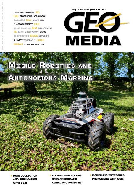
On the cover the<br />
sensorized mobile<br />
platform developed<br />
at University of<br />
Udine, Italy.<br />
geomediaonline.it<br />
<strong>GEOmedia</strong>, published bi-monthly, is the Italian magazine for<br />
geomatics. Since more than 20 years publishing to open a<br />
worldwide window to the Italian market and vice versa.<br />
Themes are on latest news, developments and applications in<br />
the complex field of earth surface sciences.<br />
<strong>GEOmedia</strong> faces with all activities relating to the acquisition,<br />
processing, querying, analysis, presentation, dissemination,<br />
management and use of geo-data and geo-information. The<br />
magazine covers subjects such as surveying, environment,<br />
mapping, GNSS systems, GIS, Earth Observation, Geospatial<br />
Data, BIM, UAV and 3D technologies.
Mobile Robotics and<br />
Autonomous Mapping:<br />
Technology for a more<br />
Sustainable Agriculture<br />
by Eleonora Maset,<br />
Lorenzo Scalera,<br />
Diego Tiozzo Fasiolo<br />
16<br />
ADV<br />
Ampere 45<br />
Epsilon 33<br />
Esri Italia 23<br />
Geomax 31<br />
Gter 15<br />
INTERGEO 35<br />
Nais 39<br />
Planetek 48<br />
Stonex 47<br />
Strumenti Topografici 2<br />
Geographical<br />
Information: Our<br />
Associations and ...<br />
the Big Tech<br />
by Valerio Zunino<br />
20<br />
Teorema 46<br />
In the background image:<br />
Bonn, Germany. This Esa<br />
Image of the week, also featured<br />
on the Earth from<br />
Space video programme, was<br />
captured by the Copernicus<br />
Sentinel-2 mission, that with<br />
its high-resolution optical camera,<br />
can image up to 10 m<br />
ground resolution.<br />
(Credits: ESA)<br />
26<br />
Time and<br />
Longitude: an<br />
unexpected<br />
affinity<br />
by Marco Lisi<br />
Chief Editor<br />
RENZO CARLUCCI, direttore@rivistageomedia.it<br />
Editorial Board<br />
Vyron Antoniou, Fabrizio Bernardini, Caterina Balletti,<br />
Roberto Capua, Mattia Crespi, Fabio Crosilla,<br />
Donatella Dominici, Michele Fasolo, Marco Lisi,<br />
Flavio Lupia, Luigi Mundula, Beniamino Murgante,<br />
Aldo Riggio, Monica Sebillo, Attilio Selvini, Donato Tufillaro<br />
Managing Director<br />
FULVIO BERNARDINI, fbernardini@rivistageomedia.it<br />
Editorial Staff<br />
VALERIO CARLUCCI, GIANLUCA PITITTO,<br />
redazione@rivistageomedia.it<br />
Marketing Assistant<br />
TATIANA IASILLO, diffusione@rivistageomedia.it<br />
Design<br />
DANIELE CARLUCCI, dcarlucci@rivistageomedia.it<br />
MediaGEO soc. coop.<br />
Via Palestro, 95 00185 Roma<br />
Tel. 06.64871209 - Fax. 06.62209510<br />
info@rivistageomedia.it<br />
ISSN 1128-8132<br />
Reg. Trib. di Roma N° 243/2003 del 14.05.03<br />
Stampa: System Graphics Srl<br />
Via di Torre Santa Anastasia 61 00134 Roma<br />
Paid subscriptions<br />
Science & Technology Communication<br />
<strong>GEOmedia</strong> is available bi-monthly on a subscription basis.<br />
The annual subscription rate is € 45. It is possible to subscribe at any time via<br />
https://geo4all.it/abbonamento. The cost of one issue is € 9 €, for the previous<br />
issue the cost is € 12 €. Prices and conditions may be subject to change.<br />
Issue closed on: 28/07/<strong>2022</strong><br />
una pubblicazione<br />
Science & Technology Communication
FOCUS<br />
From the field to the clouds:<br />
data collection and<br />
publication with QGIS<br />
By Paolo Cavallini, Matteo Ghetta, Ulisse Cavallini<br />
Open source GIS, and in particular QGIS, is a leading free and open<br />
source solution for desktop mapping since many years already.<br />
Its versatility, ease of use, and analytical power have made it the<br />
software of choice for many professionals around the world (see<br />
https://analytics.qgis.org). Field data collection and checking, and<br />
web publication are attracting more attention in the recent years.<br />
A whole suite of integrated tools is now available to implement a<br />
complete workflow, all centered on QGIS.<br />
Central to all tools is the QGIS project, designed and created using<br />
QGIS Desktop. Its power in creating beautiful and rich styling is<br />
probably unsurpassed, with expression-based styling, fusion modes,<br />
and a huge set of other functions. The same project can be used on a<br />
mobile device, and exposed through a web service (WMS, WFS, WCS,<br />
WPS) and a complete web interface.<br />
Mobile<br />
Over the 20+ of life of QGIS,<br />
a number of mobile interfaces<br />
have been designed, from<br />
the first attempt to run the<br />
whole of QGIS on Android,<br />
or a simplified interface on<br />
Windows Mobile, to proper<br />
mobile apps. Currently the<br />
most important and used<br />
solutions to use QGIS on a<br />
mobile are Qfield (https://<br />
qfield.org/) and MerginMaps<br />
(https://merginmaps.com/).<br />
Both are generic tools, that<br />
can be effectively employed<br />
in a wide variety of contexts.<br />
Their flexibility stems from<br />
the ease with which they<br />
can be configured, simply<br />
through QGIS projects, that<br />
include sophisticated styling<br />
and simple to complex forms,<br />
with all expected functionalities<br />
such as custom menus<br />
(drop-down, checkbox,<br />
calendar etc.), relations,<br />
constraints, default values,<br />
user guiding tips, etc. While<br />
still relatively new entries in<br />
the market, they have been<br />
successfully employed in<br />
extensive surveys, from single<br />
users up to thousands of field<br />
surveyors simultaneously collecting<br />
data in the field.<br />
MerginMaps<br />
MerginMaps is a web service,<br />
written in Python with flask,<br />
that manages the synchronization<br />
process of a QGIS<br />
6 <strong>GEOmedia</strong> n°3-<strong>2022</strong>
FOCUS<br />
project, and all the related<br />
files. For media files, it is<br />
not unlike other cloud file<br />
management service. Unlike<br />
other cloud file managers,<br />
though, MerginMaps is able<br />
to manage geospatial information,<br />
primarily in the form<br />
of geopackage files. When a<br />
new version of a geopackage<br />
is uploaded, for example because<br />
a surveyor added some<br />
features and is uploading<br />
them back on the centralized<br />
server, the geodiff library is<br />
used to check for changes,<br />
merge them and solve any<br />
conflicts. This enables some<br />
flexibility in the downloading<br />
and uploading of new data,<br />
since multiple surveyors can<br />
add features for their area<br />
of interest, upload different<br />
versions of the modified geopackage,<br />
and MerginMaps<br />
will take care of adding every<br />
new feature to the centralized<br />
repository.<br />
Lutra Consulting, the firm<br />
developing MerginMaps,<br />
offers an official hosted instance,<br />
a reliable way to use<br />
MerginMaps without the<br />
need for configuration and<br />
installation on a local server.<br />
The official hosted instance<br />
offers a generous free trial<br />
for non-commercial usage.<br />
Pricing is clear and reasonable,<br />
with no per-user pricing,<br />
and the support is quick and<br />
responsive.<br />
The surveying process is effectively<br />
split in two. The<br />
first phase involves the generation<br />
of the QGIS project,<br />
the related layers, and the<br />
form structure, and the<br />
subsequent upload to the<br />
MerginMaps web service. Far<br />
from being complicated, this<br />
phase still requires a good understanding<br />
of GIS software<br />
and data formats.<br />
Once the project is uploaded<br />
and ready, the surveying phase<br />
can begin. Due to the easeof-use<br />
of the mobile application,<br />
the surveying requires<br />
minimal technical skill, and<br />
operators can be trained in a<br />
matter of few few days. From<br />
their point of view, the intricacies<br />
of the project are invisible:<br />
they just need to add or<br />
modify the features according<br />
to the form, preconfigured<br />
through QGIS, and click on<br />
the synchronization button<br />
once they are online. A very<br />
recent addition, the option<br />
to automatically upload new<br />
changes whenever an internet<br />
connection is detected, further<br />
simplifies this.<br />
The project folder itself is<br />
what is visible from the web<br />
interface. In order to manipulate<br />
the project, and the<br />
geospatial data, MerginMaps<br />
can be accessed from QGIS,<br />
through the official plugin,<br />
and through the MerginMaps<br />
mobile application, available<br />
for Android and iOS.<br />
The MerginMaps application<br />
has a special focus on simple<br />
UI and UX design, in order<br />
to be accessible by everyone,<br />
regardless of their GIS experience<br />
and in demanding field<br />
conditions.<br />
Qfield<br />
Qfield has been the first natively<br />
Android mobile application<br />
connected to QGIS.<br />
Downloaded around halfmillion<br />
times it is available<br />
for Android and now iOS.<br />
The idea of the usage is very<br />
simple: the user sets up a<br />
project in QGIS and thanks<br />
to the plugin QfieldSync it<br />
will be packaged in a folder.<br />
The folder created has to be<br />
copied to the device and with<br />
the App data can be collected<br />
on the field. Back to the office<br />
the data collected with<br />
the mobile device have to be<br />
copied back on the machine<br />
and re-synchronized to the<br />
original data source with the<br />
QfieldSync plugin.<br />
<strong>GEOmedia</strong> n°3-<strong>2022</strong> 7
FOCUS<br />
The App has a very simple<br />
design and it comes with a lot<br />
of features: snapping facilities,<br />
advanced form layout, pictures<br />
and interaction with the legend<br />
to name a few.<br />
The manual synchronization<br />
can be nowadays avoided<br />
thanks to QfieldCloud, a<br />
Django framework that is able<br />
to store and automatically<br />
synchronize the data from the<br />
computer to the mobile device<br />
and vice versa. Open Source,<br />
QfieldCloud is still in Beta<br />
version and let the user choose<br />
between installing the software<br />
on the server or register to the<br />
web with a free plan (limited<br />
space) or buy additional space.<br />
The main advantage of<br />
QfieldCloud is that the user<br />
can log in both on the machine<br />
and on the device with the<br />
same name and immediately<br />
synchronize the data between<br />
all the devices. The QfieldSync<br />
plugin in QGIS has all the<br />
options needed to log in, synchronize<br />
and also see the data<br />
changes difference.<br />
8 <strong>GEOmedia</strong> n°3-<strong>2022</strong>
FOCUS<br />
As for Mergin, also Qfield<br />
has the possibility of using a<br />
server managed by OpenGIS.<br />
ch, the firm developing it<br />
without the need for configuration<br />
and installation on a<br />
local server.<br />
Web<br />
A number of different web<br />
interfaces have been designed<br />
around QGIS. For all of<br />
them the basic mechanism is<br />
the same: all user requests are<br />
sent to the backend (QGIS<br />
Server) that creates the map<br />
and other objects (legend,<br />
print layouts etc.) and send<br />
them back to the web app.<br />
The main advantages over<br />
other free and open source<br />
webGIS solutions are the ease<br />
to create both visually sophisticated<br />
maps, and complex<br />
print and reporting through<br />
QGIS Desktop layouts, without<br />
the need for specific<br />
web skills.<br />
The most widely used is<br />
Lizmap, created and maintained<br />
by 3Liz, a South French<br />
company, who also substantially<br />
contributes from years<br />
to core QGIS development.<br />
As for the other solutions<br />
described, also Lizmap can<br />
be used without the need for<br />
configuration and installation<br />
on a local server through a<br />
service managed and maintained<br />
by 3Liz, the firm developing<br />
it.<br />
Case study<br />
MerginMaps was recently<br />
used in a project geared towards<br />
the improvement of<br />
water resources infrastructure<br />
in The Gambia, financed by<br />
the African Development<br />
Bank; the project is headed<br />
by Hydronova, and its GIS<br />
section is technically managed<br />
by Faunalia.<br />
Special acknowledgment<br />
for this project goes for the<br />
continuous support to the<br />
Climate Smart Rural WASH<br />
Development Project Office<br />
Team and to the Department<br />
of Water Resources Staff, under<br />
the Ministry of Fisheries<br />
and Water Resources of the<br />
Gambia.<br />
Data collection is the first<br />
task upon which the whole<br />
project is built, since in order<br />
to improve resource management,<br />
key stakeholders need<br />
to know the current situation<br />
and distribution of the resources<br />
at their disposal.<br />
An open source solution<br />
is ideal in most contexts,<br />
even more so in a context<br />
where free access to data is<br />
paramount, and budget constraints<br />
are tight.<br />
The MerginMaps mobile<br />
application, backed by the<br />
Mergin web service, was chosen<br />
due to its ease of use and<br />
synchronization. Due to the<br />
possibility and ease of setting<br />
up a Mergin instance, all the<br />
data was kept in-situ at the<br />
relevant ministry, retaining<br />
control on this crucial information.<br />
A QGIS project with four<br />
layers, each with a custom<br />
form, was created. In order<br />
to have all the data fully offline,<br />
vector tiles were used.<br />
These were generated, for the<br />
whole country, by extracting<br />
OpenStreetMaps data, packaging<br />
it in an mbtiles file, and<br />
<strong>GEOmedia</strong> n°3-<strong>2022</strong> 9
FOCUS<br />
by styling them with one of<br />
the OpenMapTiles styles.<br />
The resulting project was<br />
only 16 MB, a small fraction<br />
of the 160+ MB that would<br />
have been needed for rasterized<br />
tiles.<br />
Using the QGIS drag-n-drop<br />
form, extensive logic was<br />
introduced in the data entry<br />
user interface. With this<br />
setup, users were guided in<br />
choosing the three different<br />
administrative levels from a<br />
drop down, with automatic<br />
filtering of the available options,<br />
and constraints with<br />
appropriate description were<br />
implemented. For water<br />
sources, which are of upmost<br />
importance, a photo was also<br />
required.<br />
After the project was tested,<br />
teams of surveyors covered<br />
the whole country in the span<br />
of a few months, while the<br />
survey manager constantly<br />
analyzed data quality with<br />
spot crosschecks.<br />
Periodically, the tablets were<br />
brought back online, and<br />
the data was synchronized.<br />
In this process, the selective<br />
sync option, introduced in<br />
MerginMaps (at the time called<br />
Input) 1.0.1, was crucial.<br />
This feature instructs all the<br />
tablets to upload the pho-<br />
tos that were taken locally,<br />
without downloading all<br />
of the other media in the<br />
project, that was added by<br />
other surveyors. Without<br />
this, more than 15 GB of<br />
photos would have been<br />
downloaded into each tablet,<br />
severely impairing the<br />
synchronization process and<br />
requiring a stable and fast<br />
internet connection.<br />
At the completion of the<br />
survey, the data was checked<br />
and cleaned, then it<br />
was synchronized with a<br />
PostgreSQL/PostGIS database,<br />
using the mergin-dbsync<br />
tool, as described in<br />
the “Extensions and integrations”<br />
section. This procedure<br />
initialized the new<br />
database, and ensures that<br />
any change in the data will<br />
be reflected in the database<br />
tables.<br />
Using the newly initialized<br />
database, a second QGIS<br />
project based on the same<br />
data was created and published<br />
on a WebGIS based on<br />
QGIS server and Lizmap,<br />
thus reusing QGIS styling<br />
without the need for restyling<br />
and conversion. In<br />
this phase, the advanced<br />
forms could be reused, thus<br />
showing on the website all<br />
the information as entered<br />
by the surveyor, including<br />
the water source photo.<br />
Other layers, such as the<br />
administrative subdivisions,<br />
were added, as well as the<br />
localization tool, that enables<br />
any user to quickly find<br />
the current location, a village,<br />
or an area of interest.<br />
By combining the efficiency<br />
of PostgreSQL materialized<br />
view, and the flexibility<br />
of the QGIS print layout,<br />
multiple layouts were created<br />
and personalized for<br />
each administrative level,<br />
10 <strong>GEOmedia</strong> n°3-<strong>2022</strong>
FOCUS<br />
from country aggregates to<br />
the village level. Graphs created<br />
with DataPlotly, a recent<br />
addition to the QGIS print<br />
layout, were also used.<br />
These layouts were then exposed<br />
in Lizmap with the<br />
AtlasPrint QGIS Server plugin.<br />
Extensions and integrations<br />
MerginMaps, being written<br />
in Python, with good documentation,<br />
has quite a few<br />
extensions, that enable it to<br />
adapt to the specific needs of<br />
most survey projects.<br />
Mergin-db-sync, first released<br />
in June 2020, is a crucial<br />
part of the MerginMaps<br />
offering. Also written in<br />
Python, it interfaces with the<br />
main Mergin web service and<br />
with a PostgreSQL/PostGIS<br />
database, keeping the two<br />
in constant sync. Whenever<br />
a change is detected in the<br />
specified geopackage, the<br />
changes are propagated to the<br />
PostgreSQL database, and<br />
vice versa. Strict versioning<br />
is still maintained, since the<br />
tool creates a new version of<br />
the MerginMaps project, just<br />
as a user uploading new data<br />
would. The tool uses two<br />
PostgreSQL schemas, one in<br />
which changes can be made<br />
directly, and a backup copy<br />
used to check for changes.<br />
It utilizes the geodiff library<br />
to check and merge changes,<br />
even if they happen in the<br />
two backends at the same<br />
time. Mergin-db-sync can<br />
also be used to expose the<br />
data on a WebGIS such as<br />
Lizmap.<br />
Mergin-media-sync, first<br />
released in December 2021,<br />
allows for the offloading of<br />
the media files, often representing<br />
a good chunk of the<br />
project size, to a local drive,<br />
or to the MinIO object storage.<br />
When new media files<br />
are added, the tool downloads<br />
them, uploads them to<br />
the configured service, and<br />
updates the relevant rows in<br />
the geopackage, pointing the<br />
media path to the new url. In<br />
a wide-area survey, covering<br />
many features and containing<br />
photos, this tool can effectively<br />
be used to avoid cluttering<br />
the MerginMaps project<br />
with hundreds of gigabytes of<br />
images.<br />
Both MerginMaps and<br />
QField can be used with an<br />
external GPS/GNSS device,<br />
that can be obtained at a low<br />
cost, enabling high precision<br />
location, up to a centimeter<br />
of accuracy. These devices,<br />
once highly priced, are now<br />
accessible and reliable.<br />
METAKEYS<br />
field survey; water resources; qgis; qfield<br />
ABSTRACT<br />
QGIS is the leading free and open source<br />
desktop GIS. It is also a complete ecosystem,<br />
that allows to build complete workflows, from<br />
field data collection to publication on the web.<br />
Central to it are QGIS projects, that define<br />
data sources, projections, styling and integration,<br />
and are reused from mobile to the web<br />
without a need to reconfigure them. We describe<br />
the main solutions available for data collection<br />
and seamless publication over the web:<br />
MerginMaps, Qfield, Lizmap, with an example<br />
form a water resources project in Gambia.<br />
AUTHOR<br />
Paolo Cavallini<br />
cavallini@faunalia.it<br />
Matteo Ghetta<br />
matteo.ghetta@faunalia.eu<br />
Ulisse Cavallini<br />
ulisse.cavallini@faunalia.it<br />
Faunalia<br />
www.faunalia.eu<br />
Piazza Garibaldi 4, 56025 Pontedera<br />
(PI), Italy<br />
<strong>GEOmedia</strong> n°3-<strong>2022</strong> 11
FOCUS<br />
Open-source GIS software and components<br />
for modelling watershed phenomena<br />
Understanding the soil and water components under<br />
different management options with QGIS and the SWAT+<br />
By Flavio Lupia and Giuseppe Pulighe<br />
Fig. 1 – Workflow with input and output components for running SWAT+ through the QSWAT plugin for QGIS.<br />
Modelling the<br />
watershed balance<br />
Current and future climate<br />
change are expected to increase<br />
our challenges in preserving<br />
natural resources and ecosystem<br />
services. At the watershed scale,<br />
the processes taking places<br />
relate to interactions between<br />
soil and water and are influenced<br />
by land use management.<br />
Precipitation, infiltration, runoff,<br />
evapotranspiration, soil<br />
erosion, soil and water pollutions<br />
are the main components<br />
to be considered whenever for<br />
the simulation of the watershed<br />
system within the current and<br />
future conditions under changing<br />
drivers (i.e., human interventions<br />
and climate change).<br />
One of the most popular watershed<br />
modelling tools is the<br />
Soil and Water Assessment Tool<br />
(SWAT), a public domain model<br />
jointly developed by USDA<br />
Agricultural Research Service<br />
and Texas A&M University<br />
(Arnold et al., 1998). SWAT<br />
has been used worldwide for<br />
different applications (water<br />
quality, land use, soil erosion,<br />
crop yield, etc.) during the last<br />
four decades. As of May <strong>2022</strong>,<br />
a total of 5154 articles report<br />
SWAT applications within<br />
different journals according to<br />
the SWAT Literature Database<br />
(https://www.card.iastate.edu/<br />
swat_articles/).<br />
SWAT enables the simulation of<br />
watershed and river basin quantity<br />
and quality of surface and<br />
ground water under the influence<br />
of land use, management,<br />
and climate change. It can be<br />
used to monitor and control soil<br />
erosion, non-point source pollution<br />
and basin management. An<br />
entirely reconstructed version of<br />
SWAT, nicknamed SWAT+, was<br />
only launched in recent years<br />
to improve the capabilities of<br />
SWAT code maintenance and<br />
future development. Reservoir<br />
operation functions have been<br />
added to SWAT+ in addition<br />
to the new model structure to<br />
increase model simulation performance.<br />
Now, the physical<br />
objects (hydrologic response<br />
units (HRUs), aquifers, canals,<br />
ponds, reservoirs, point sources,<br />
and inlets) are built as separate<br />
modules.<br />
QSWAT: the QGIS plugin for<br />
the new SWAT+ model<br />
SWAT model was implemented<br />
withing the GIS environment<br />
with dedicated plugins both for<br />
commercial and open-source<br />
GIS platforms. The GIS imple-<br />
12 <strong>GEOmedia</strong> n°3-<strong>2022</strong>
FOCUS<br />
mentations has allowed users to<br />
manage more efficiently the watershed<br />
modelling process in its<br />
natural environment, the GIS,<br />
where the spatial component<br />
of the various datasets can be<br />
handled straightforwardly.<br />
QSWAT is the most recent<br />
implementation as QGIS plugin,<br />
written in Python, of the<br />
new version SWAT+. As of 6th<br />
April <strong>2022</strong>, QSWAT3 v1.5 for<br />
QGIS3 was released for 32 and<br />
64bit machines. SWAT+ is written<br />
in FORTRAN and is also<br />
available as command-line executable<br />
file that runs text file inputs<br />
without interface (SWAT+<br />
installer 2.1.0 was released on<br />
31 March <strong>2022</strong> for Windows,<br />
Linux, and MacOS). QSWAT<br />
is increasingly gaining momentum<br />
thanks to the spreading<br />
and robustness of the opensource<br />
GIS platform. QGIS has<br />
a huge number of users and a<br />
solid reputation. It is utilized in<br />
academic and professional settings,<br />
and it has been translated<br />
into more than 48 languages.<br />
Moreover, the release of SWAT<br />
code as open source has benefitted<br />
the diffusion and improvement<br />
of the model by making<br />
it more robust and suitable for<br />
different applications thanks<br />
to the collaboration of several<br />
users with various expertise.<br />
Different channels are available<br />
for users’ collaboration such as<br />
QSWAT user group, SWAT+<br />
Editor user group and SWAT+<br />
model user group (https://swat.<br />
tamu.edu). Other plugins are<br />
also available, such as the one<br />
developed for the commercial<br />
ESRI ARCGIS (ArcSWAT).<br />
Beyond the functions provided<br />
by QSWAT for setting<br />
the watershed to be analysed,<br />
SWAT+ is complemented by<br />
additional software: SWAT<br />
Editor (a user interface for<br />
modifying SWAT+ inputs and<br />
running the model installed<br />
Fig. 2 – Spatial distribution of annual means of the actual evapotranspiration from the soil at subbasin scale for a<br />
watershed through QSWAT.<br />
along with QSWAT), SWAT+<br />
Toolbox (a user-friendly tool<br />
for SWAT+ for sensitivity<br />
analysis, manual and automatic<br />
calibration), SWATplus-CUP<br />
(the Calibration Uncertainty<br />
Program for SWAT+ requiring<br />
a license purchase) and<br />
SWATplusR (a set of tools<br />
taking advantage of the R environment<br />
for parameter sensitivity<br />
analysis, model calibration<br />
and the analysis model results).<br />
Moreover, the SWAT website<br />
provides datasets for running<br />
the model even if specific datasets,<br />
with adequate spatial and<br />
temporal resolution, are always<br />
recommended for the study<br />
areas to be analysed. The datasets<br />
available have often global<br />
coverage and are relative to climate,<br />
soil, land use and Digital<br />
Elevation Models (DEMs).<br />
Look up tables are also supplied<br />
with QSWAT to properly<br />
match to standard legends the<br />
land use and soil codes.<br />
The four-steps process and the<br />
minimum set of data for running<br />
SWAT+<br />
The following spatial and tabular<br />
data are required for running<br />
SWAT+: Land use/cover, DEM,<br />
Soil data (hydrological group,<br />
clay, silt, sand), Climate data<br />
(temperature, precipitation,<br />
humidity, solar radiation, wind<br />
speed) and Hydrology (river<br />
discharge).<br />
QSWAT runs SWAT+ by following<br />
a four-step procedure: 1)<br />
Delineate watersheds, 2) Create<br />
Hydrologic Response Units<br />
(HRUs), 3) Edit inputs and run<br />
SWAT, and 4) Visualize.<br />
The first step deals with the<br />
definition of the watershed and<br />
its structure by extracting the<br />
channels and the watershed<br />
boundary by processing the<br />
DEM of the study area with<br />
the classical Terrain Analysis<br />
Using Digital Elevation Models<br />
(TauDEM) functions that<br />
divide the watershed in subbasins<br />
(areas with a principal<br />
stream channel). The second<br />
step involves the creation of<br />
the HRUs, lumped areas with<br />
the same combination of soil,<br />
topography, and land use, not<br />
spatially related to each other<br />
(Rathjens et al., 2016). The<br />
third step concerns the weather<br />
data selection and the set-up<br />
of model parameters. For instance,<br />
the latter are relative<br />
to the potential evapotranspiration<br />
method (e.g., Priestley-<br />
<strong>GEOmedia</strong> n°3-<strong>2022</strong> 13
FOCUS<br />
Taylor, Penman-Monteith or<br />
Hargreaves), curve number<br />
method for soil moisture, land<br />
use management and conservation<br />
practices. The fourth step<br />
is dedicated to the visualization<br />
of the results at basin and subbasin<br />
scale and to the outputs<br />
exploration for a given channel<br />
and gauge.<br />
The model can simulate daily,<br />
monthly, yearly, and average<br />
outputs for different model<br />
components (e.g., channel,<br />
aquifer, reservoir, etc.), for nutrient<br />
balance, water balance,<br />
plant weather and losses from<br />
the basin, HRUs and landscape<br />
units. Results can be printed<br />
and exported in different formats<br />
such as tabular or text<br />
structure.<br />
Calibration and validation<br />
After the SWAT+ run and the<br />
production of the outputs, model<br />
calibration and validation<br />
are strongly recommended.<br />
The model can be calibrated<br />
and validated for hydrologic,<br />
sediment, nitrogen, and phosphorus<br />
components. These<br />
last steps guide the user on<br />
the fine-tuning process of the<br />
model parameters to produce<br />
results coherent with the real<br />
watershed processes. It requires<br />
the collection of data on river<br />
discharge that are often missing<br />
for several watersheds or<br />
available in analogic format,<br />
moreover water quality data<br />
(e.g., sediments load, dissolved<br />
oxygen, nitrate and phosphorous<br />
concentrations, etc.) can<br />
be used. Alternative approaches<br />
for hydrology calibration may<br />
involve the use of evapotranspiration<br />
data from satellite data<br />
to overcome the lack of river<br />
discharge data from the gauge<br />
stations at the outlets. SWAT+<br />
allows several options for calibrating<br />
and validating the<br />
simulation under the different<br />
parametrizations defined by<br />
the users. A sensitivity analysis<br />
is quite common approach<br />
undertaken to pinpoint the<br />
main sensitive parameters and<br />
to reduce their redundancy during<br />
cal/val process. Literature<br />
review is always useful to start<br />
listing a set of common parameters<br />
affecting streamflow and<br />
sediment yield process. SWAT-<br />
Calibration and Uncertainty<br />
Programs (SWAT-CUP) is by<br />
Fig. 3 – Schematic representation of the hydrology outputs at watershed level through QSWAT.<br />
far the most known tool for<br />
assessing the sensitivity of parameters<br />
by providing several<br />
model evaluation techniques<br />
based on the relevant statistics<br />
(e.g., Pearson’s correlation<br />
coefficient, root mean square<br />
error (RMSE), etc.). Following<br />
the identification of the most<br />
sensitive parameters the calibration<br />
and validation phase<br />
are carried out by focussing on<br />
specific components (e.g., daily<br />
discharge). The time series of<br />
the available data (e.g., t0-tn) is<br />
divided to provide a reference<br />
period for the warm-up (e.g.,<br />
t0-t5), calibration (e.g., t6-t15)<br />
and validation (e.g., t16-tn).<br />
Finally, model performances<br />
are assessed by using classical<br />
statistic measures (e.g., RMSE).<br />
Calibration and validation can<br />
be long and tedious. Therefore,<br />
it is always recommended to<br />
follow a precise work protocol<br />
(Abbaspour et al. 2018).<br />
Extending model simulation capabilities:<br />
land use management<br />
and climate change<br />
The impact of alternative land<br />
uses, and climate change are<br />
pressing concerns in different<br />
regions of the world. SWAT+<br />
allows modelling diverse land<br />
use scenarios to meet sustainability<br />
goals (Pulighe et. al.,<br />
2020) through a module where<br />
alternative land management<br />
practices can be defined (e.g.,<br />
ploughing, seeding, tillage, irrigation,<br />
fertilization rates and<br />
crop nutrients uptake, etc.),<br />
by defining dates or specific<br />
land use classes and regions.<br />
Similarly, climate projections<br />
from climate models under different<br />
representative concentration<br />
pathways (RCPs) scenarios<br />
of greenhouses emissions can be<br />
loaded as weather data to create<br />
climate scenarios for the future<br />
decades that can be compared<br />
to the baseline period covering<br />
the historical meteorological<br />
data. SWAT+ can ingest these<br />
14 <strong>GEOmedia</strong> n°3-<strong>2022</strong>
FOCUS<br />
data for simulating seasonal<br />
changes in precipitation and<br />
temperatures, hydrological extremes,<br />
flow regime alterations<br />
and river discharge, future water<br />
quality (i.e., nitrogen and<br />
phosphorus) and soil erosion<br />
conditions, and future biomass<br />
production. Estimating<br />
the mentioned effects on the<br />
hydrological regime might have<br />
strong impacts also on agricultural<br />
activities posing challenges<br />
to land use management and<br />
irrigation (Pulighe et al., 2021).<br />
Conclusions<br />
Open-source GIS (QGIS)<br />
and free to use models such<br />
as SWAT+ can be considered<br />
effective and strategic tools for<br />
monitoring and assessing water<br />
and soil interactions at the<br />
watershed level. In addition,<br />
the growing availability of public<br />
domain geospatial datasets<br />
can increase the applicability<br />
of the simulation of the watershed<br />
processes worldwide and<br />
for a wide variety of use cases.<br />
QSWAT will be a valuable<br />
tool for the SWAT scientific<br />
community thanks to the full<br />
integration with the geospatial<br />
functions, the new functionality<br />
offered by SWAT+ and<br />
the contribution of a wide and<br />
growing open-source community.<br />
QSWAT could be a powerful<br />
tool to assess the effects<br />
of climate change and land use<br />
management and the impacts<br />
on water quality and land degradation.<br />
We believe that in<br />
the near future, the evaluation<br />
of the effectiveness of policy interventions<br />
and the deployment<br />
of sustainable soil/water management<br />
practices will become<br />
an interesting arena for experimenting<br />
and acknowledging the<br />
potentiality of SWAT+.<br />
REFERENCES<br />
Arnold, J. G., Srinivasan, R., Muttiah, R. S., & Williams,<br />
J. R. (1998). Large area hydrologic modeling<br />
and assessment part I: model development 1. JAWRA<br />
Journal of the American Water Resources Association,<br />
34(1), 73-89.<br />
Abbaspour KC, Vaghefi SA, Srinivasan R. A Guideline<br />
for Successful Calibration and Uncertainty<br />
Analysis for Soil and Water Assessment: A Review of<br />
Papers from the 2016 International SWAT Conference.<br />
Water. 2018; 10(1):6. https://doi.org/10.3390/<br />
w10010006<br />
Pulighe, G., Lupia, F., Chen, H., & Yin, H. (2021).<br />
Modeling Climate Change Impacts on Water Balance<br />
of a Mediterranean Watershed Using SWAT+. Hydrology,<br />
8(4), 157.<br />
Pulighe G, Bonati G, Colangeli M, Traverso L, Lupia<br />
F, Altobelli F, Dalla Marta A, Napoli M. Predicting<br />
Streamflow and Nutrient Loadings in a Semi-Arid<br />
Mediterranean Watershed with Ephemeral Streams<br />
Using the SWAT Model. Agronomy. 2020; 10(1):2.<br />
https://doi.org/10.3390/agronomy10010002<br />
Rathjens, H., Bieger, K., Srinivasan, R., Chaubey, I.,<br />
& Arnold, J. G. (2016). CMhyd user manual. Doc.<br />
Prep. Simulated Clim. Change Data Hydrol. Impact<br />
Study.<br />
https://www.card.iastate.edu/swat_articles/<br />
https://swat.tamu.edu<br />
METAKEYS<br />
QGIS; QSWAT; watershed; river basin; SWAT+;<br />
climate change<br />
ABSTRACT<br />
The Soil and Water Assessment Tool (SWAT) enables<br />
the simulation of watershed and river basin quantity<br />
and quality of surface and ground water under the influence<br />
of land use, management, and climate change.<br />
It can be used to monitor and control soil erosion,<br />
non-point source pollution and basin management.<br />
The recent version (SWAT+) was implemented by<br />
a dedicated QGIS plugin (QSWAT) widening the<br />
userbase and the potential modelling application<br />
worldwide. QSWAT, along with additional software<br />
for preparing the input dataset and for performing<br />
the calibration/validation phase, further extends the<br />
watershed modelling capabilities. Such tools and the<br />
growing diffusion of public open geospatial datasets<br />
are expected to increase the range of applications especially<br />
with the availability climate projections datasets.<br />
The latter will enable users to simulate all the watersoil<br />
phenomena at watershed level under future conditions<br />
to better understand and plan suitable action for<br />
preserving the natural resources.<br />
AUTHOR<br />
Flavio Lupia<br />
flavio.lupia@crea.gov.it<br />
Giuseppe Pulighe<br />
giuseppe.pulighe@crea.gov.it<br />
CREA - Council for Agricultural Research<br />
and Economics - Roma (Italy)<br />
<strong>GEOmedia</strong> n°3-<strong>2022</strong> 15
REPORT<br />
Mobile Robotics and Autonomous<br />
Mapping: Technology for a more<br />
Sustainable Agriculture<br />
by Eleonora Maset, Lorenzo Scalera, Diego Tiozzo Fasiolo<br />
Fig. 1 - The mobile robot traversing under the canopy in a<br />
maize field (Manish et al., <strong>2022</strong>).<br />
Today, food systems account<br />
for nearly onethird<br />
of global greenhouse gas<br />
emissions, consume<br />
large amounts of natural<br />
resources and are among the<br />
causes of biodiversity loss.<br />
As part of the actions of<br />
the European Green<br />
Deal, the Farm to Fork<br />
Strategy (European Commission,<br />
2020) plays therefore a<br />
crucial role to reach the ambitious<br />
goal of making Europe a<br />
climate-neutral continent by<br />
2050. In fact, it aims to accelerate<br />
the transition towards a<br />
sustainable food system, reducing<br />
dependency on pesticides,<br />
decreasing excess fertilization<br />
and protecting land, soil, water,<br />
air, plant and animal health. All<br />
actors of the food chain need to<br />
contribute to the implementation<br />
of this strategy, starting<br />
from the transformation of<br />
production methods that can<br />
benefit from novel technological<br />
and digital solutions to deliver<br />
better environmental and climate<br />
results.<br />
In this context, we are witnessing<br />
an increasing demand for<br />
automated solutions to monitor<br />
and inspect crops and canopies,<br />
that are driving the adoption of<br />
autonomous and robotic systems<br />
with computational and<br />
logical capabilities. The introduction<br />
of robotics and automation,<br />
coupled with Geomatics<br />
techniques, could provide notable<br />
benefits not only in terms<br />
of crop production and land use<br />
optimization, but also to reduce<br />
the use of chemical pesticides,<br />
improving sustainability and<br />
climate performance through<br />
a more results-oriented model,<br />
based on the use of updated<br />
data and analyses. For these reasons,<br />
the implementation of autonomous<br />
and robotic solutions<br />
together with advanced monitoring<br />
techniques is becoming<br />
of paramount importance in<br />
view of a resilient and sustainable<br />
agriculture.<br />
Applications of mobile robotics<br />
in agriculture span from a large<br />
variety of tasks, as for instance,<br />
harvesting, monitoring, phenotyping,<br />
sowing, and weeding. A<br />
particular task in which mobile<br />
robots are currently employed<br />
at a faster pace than in previous<br />
years is 3D mapping, as testified<br />
by a flourishing literature<br />
on the topic (Tiozzo Fasiolo et<br />
al., <strong>2022</strong>). Indeed, 3D maps of<br />
agricultural crops can provide<br />
valuable information about the<br />
health, stress, presence of diseases,<br />
as well as morphological and<br />
biochemical characteristics. Furthermore,<br />
3D surveys of plants<br />
and crops are fundamental in<br />
the computation of geometrical<br />
information, such as volume<br />
and height, to be used to reduce<br />
pesticide and fertilizer waste<br />
and water usage, and, therefore,<br />
improve sustainability and environmental<br />
impact.<br />
Obviously, to provide useful<br />
information for crop management<br />
and to perform the survey<br />
in the most automatic way possible,<br />
robotics platforms must<br />
be equipped with appropriate<br />
technology. In the following, we<br />
will therefore try to summarize<br />
trends and future developments<br />
16 <strong>GEOmedia</strong> n°3-<strong>2022</strong>
REPORT<br />
in this domain.<br />
The first requirement of mobile<br />
robots in agriculture applications<br />
is the availability of onboard<br />
sensors and computational capabilities.<br />
Common sensors are<br />
2D and 3D LiDAR (Light Detection<br />
and Ranging), cameras<br />
(monocular, stereo, RGB-D, and<br />
time-of-flight ones), as well as<br />
RTK-GNSS (Real-Time Kinematics<br />
Global Navigation Satellite<br />
System) receivers, and IMUs<br />
(Inertial Measurement Units),<br />
the latter two used mainly for<br />
localization tasks.<br />
Among the robotic systems recently<br />
proposed in the literature<br />
for 3D mapping in agriculture,<br />
it is worth mentioning the platform<br />
developed in (Manish et<br />
al., 2021) and shown in Figure<br />
1. That system is capable of collaborating<br />
with a drone to build<br />
a dense point cloud of the field.<br />
Another interesting mobile robot<br />
is BoniRob (Figure 2), developed<br />
by Bosch Deepfield® Robotics<br />
(Chebrolu et al., 2017). It is an<br />
omnidirectional robot and carries<br />
a multispectral camera, able<br />
to register four spectral bands,<br />
and an RGB-D sensor to capture<br />
high-resolution radiometric data<br />
about the inspected plantation.<br />
Multiple LiDAR sensors and<br />
GNSS receivers as well as wheel<br />
encoders provide at the same<br />
time observations employed for<br />
localization, navigation, and<br />
mapping. An example of robot<br />
with an onboard manipulator<br />
is given by BrambleBee (Ohi et<br />
al., 2018). That robotic system<br />
features a custom end effector<br />
designed to pollinating flowers<br />
in a greenhouse.<br />
Images from standard RGB<br />
cameras only supply information<br />
about the plants in the visible<br />
spectrum. To investigate vegetation<br />
indexes related to the crop<br />
vigor, as for instance the NDVI<br />
(Normalized Difference Vegetation<br />
Index), multispectral and<br />
Fig. 2 - Agricultural field robot BoniRob with onboard sensors (Chebrolu et al., 2017).<br />
hyperspectral sensors are needed,<br />
which can measure the near<br />
infrared radiation reflected by<br />
the vegetation leaves. However,<br />
only a paucity of robotic platforms<br />
described in the literature<br />
manage to perform this task.<br />
The mobile lab developed at<br />
the Free University of Bolzano<br />
and shown in Figure 3 is among<br />
them (Bietresato et al., 2016).<br />
A prototype of mobile robot for<br />
3D mapping in agriculture is<br />
currently being developed at the<br />
University of Udine, based on<br />
an Agile-X Robotics Scout 2.0<br />
platform (Figure 4). The robot<br />
can navigate in harsh terrain and<br />
narrow passages thanks to its<br />
four-wheel drive and differential<br />
kinematics. The platform is<br />
equipped with a low-cost GNSS<br />
receiver and a 9-degree-offreedom<br />
(DOF) IMU as direct<br />
georeferencing systems. Moreover,<br />
it features a great computational<br />
capability thanks to the<br />
NVIDIA Jetson AGX Xavier<br />
board, developed to exploit artificial<br />
intelligence (AI) algorithms<br />
even in embedded systems. The<br />
perception of the environment<br />
is guaranteed by a rotating 360°<br />
LiDAR and an RGB-D camera.<br />
Finally, for phenotyping purposes<br />
it exploits a multispectral<br />
camera pointing forward to<br />
acquire information on the near<br />
infrared and the red edge portion<br />
of the light spectrum.<br />
As far as the sensorial and<br />
computational capabilities are<br />
Fig. 3 - Agricultural robot developed at the Free University of Bolzano, Italy: robot in a orchard,<br />
and onboard sensors (Bietresato et al., 2016).<br />
<strong>GEOmedia</strong> n°3-<strong>2022</strong> 17
REPORT<br />
Fig. 4 - The sensorized mobile platform developed at University of Udine, Italy.<br />
considered, from the literature<br />
it can be noticed that most of<br />
the robotic platforms operating<br />
in the agricultural environment<br />
usually employ physical devices<br />
to store the acquired data, whose<br />
can require a frequent manual<br />
intervention of an operator. The<br />
implementation on Internet<br />
of Things (IoT) approaches,<br />
together with the storage of<br />
data on clouds could be a great<br />
improvement, making data<br />
remotely available. Future improvements<br />
in this context will<br />
also include the integration of<br />
renewable energy sources, such<br />
as solar panels, to increase the<br />
autonomy of the systems, especially<br />
in large scale operations<br />
(e.g., autonomous 3D mapping<br />
of a whole vineyard). Moreover,<br />
to avoid occlusion problems<br />
that can occur in image-based<br />
phenotyping, sensors can be<br />
mounted on a robotic arm that<br />
can optimize the camera pose,<br />
guaranteeing the best point of<br />
view for data acquisition. However,<br />
it should also be underlined<br />
that eye-in-hand configurations<br />
for LiDAR sensors and multispectral<br />
cameras are not exploited<br />
yet. A further important<br />
aspect is the durability of these<br />
systems and sensors, that should<br />
be designed to operate in severe<br />
outdoor scenarios.<br />
Fig. 5 - Person following with YOLO object detection (Masuzawa et al., 2017).<br />
To navigate autonomously in<br />
the surrounding environment, a<br />
mobile robot needs a robust localization<br />
method that can georeference<br />
the data acquired by<br />
means of the onboard sensors.<br />
Direct georeferencing methods<br />
are usually based on the RTK-<br />
GNSS, that provides position at<br />
low update rate, generally coupled<br />
with a 9-DOF IMU, which<br />
however is sensible to noise in<br />
rough terrains. Higher accuracy<br />
for the localization of the robot<br />
and the generated 3D map can<br />
be achieved using in addition<br />
Simultaneous Localization and<br />
Mapping (SLAM) approaches.<br />
As well-known also in the Geomatics<br />
community, SLAM problem<br />
consists in the estimation<br />
of the pose of the robot/sensor,<br />
while simultaneously building a<br />
map of the environment. Stateof-the-art<br />
methods are divided<br />
into two main groups: visual<br />
SLAM and LiDAR SLAM. The<br />
former approach relies on images<br />
and sequentially estimates<br />
the camera poses by tracking<br />
keypoints in the image sequence.<br />
The popular approach for Li-<br />
DAR SLAM is instead based<br />
on scan matching: the pose is<br />
retrieved by matching the newly<br />
acquired point cloud with the<br />
previously built map, which is<br />
constantly updated as soon as<br />
new observations are available.<br />
Although not yet fully implemented<br />
in mobile robots for precision<br />
agriculture applications,<br />
an optimal solution could be<br />
data fusion, taking the advantages<br />
of both visual and LiDAR<br />
SLAM methods. In addition,<br />
since external conditions can significantly<br />
vary among different<br />
application and the environment<br />
dictates the most advantageous<br />
sensor, the robot itself should be<br />
able to choose and use the most<br />
suited data source according to<br />
the environmental conditions.<br />
Many open-source SLAM algo-<br />
18 <strong>GEOmedia</strong> n°3-<strong>2022</strong>
REPORT<br />
rithms are currently available,<br />
that can run in real time or in<br />
post-processing mode. To this<br />
regard, a comparison among<br />
the state-of-the-art SLAM algorithms<br />
could be interesting,<br />
together with a quantitative<br />
evaluation of the obtained 3D<br />
maps performed with respect<br />
to ground truth datasets. Conversely,<br />
there is a lack of methods<br />
to efficiently fuse spectral data<br />
acquired by multispectral and<br />
hyperspectral cameras with Li-<br />
DAR point clouds, fundamental<br />
for agriculture applications.<br />
Another important aspect that<br />
must be considered for the<br />
profitably application of mobile<br />
platforms is the autonomous<br />
navigation ability, guaranteed by<br />
path planning algorithms. Path<br />
planning is a mature field in<br />
mobile robotics, and, in the crop<br />
monitoring context, it generally<br />
consists of providing a global<br />
path to map an entire area. This<br />
approach is called coverage path<br />
planning and is usually coupled<br />
with a row-following algorithm<br />
to provide local velocity command<br />
to the robot.<br />
A recent trend in the coverage<br />
path planning is the development<br />
of algorithms that avoid<br />
repetitive paths to minimize soil<br />
compaction. This approach generally<br />
relies on prior information<br />
of the working area, that could<br />
be acquired thanks to the collaboration<br />
with drones, useful to<br />
capture an up-to-date 2D or 3D<br />
model of the environment. Furthermore,<br />
a promising solution<br />
could be extending the range<br />
of action with swarm robotics,<br />
that is the collaboration of several<br />
unmanned ground vehicles<br />
(UGVs).<br />
Nowadays, another fundamental<br />
aid for agricultural applications<br />
based on mobile robotics is given<br />
by artificial intelligence (AI). In<br />
fact, classification and segmentation<br />
algorithms of images and<br />
point clouds based on AI are increasingly<br />
used to enrich the 3D<br />
map with semantic information,<br />
also in real time. This is possible<br />
mostly thanks to the advances in<br />
the computational performance<br />
of modern embedded computers<br />
that can be installed onboard a<br />
mobile platform.<br />
For instance, a convolutional<br />
neural network (CNN) applied<br />
to the acquired images can provide<br />
bounding boxes of objects<br />
of interest, that can constitute<br />
the basis to build a topological<br />
map with key location estimation<br />
and semantic information.<br />
This is exploitable also to give<br />
the robot person following capability,<br />
as done in the work by<br />
(Masuzawa et al., 2017) (Figure<br />
5). Another example of machine<br />
learning application is given<br />
by the work in (Reina et al.,<br />
2017), which employed a support<br />
vector machine to classify<br />
the terrain on which the robot<br />
is navigating, by means of wheel<br />
slip, rolling resistance, vibration<br />
response experienced by the<br />
mobile platform and visual data.<br />
Recent trends in this field also<br />
comprise the use of generative<br />
adversarial networks to generate<br />
photorealistic agricultural images<br />
for model training, as well as<br />
the recognition of diseases with<br />
CNN.<br />
In the coming years we will<br />
witness great progress in all the<br />
domains highlighted by this<br />
work, from sensors to mobile<br />
platforms, from localization algorithms<br />
to artificial intelligence<br />
methods, with the hope that<br />
these innovations will effectively<br />
contribute to the transition to<br />
a more sustainable, healthy and<br />
environmentally-friendly food<br />
system.<br />
REFERENCES<br />
European Commission (2020). Farm to Fork<br />
strategy for a fair, healthy and environmentallyfriendly<br />
food system. https://ec.europa.eu/food/<br />
horizontal-topics/farm-fork-strategy_en<br />
Tiozzo Fasiolo, D., Scalera, L., Maset, E.,<br />
Gasparetto, A. (<strong>2022</strong>). Recent Trends in Mobile<br />
Robotics for 3D Mapping in Agriculture. In International<br />
Conference on Robotics in Alpe-Adria<br />
Danube Region (pp. 428-435). Springer, Cham.<br />
Manish, R., Lin, Y. C., Ravi, R., Hasheminasab,<br />
S. M., Zhou, T., Habib, A. (2021). Development<br />
of a miniaturized mobile mapping system<br />
for in-row, under-canopy phenotyping. Remote<br />
Sensing, 13(2), 276.<br />
Chebrolu, N., Lottes, P., Schaefer, A., Winterhalter,<br />
W., Burgard, W., Stachniss, C. (2017).<br />
Agricultural robot dataset for plant classification,<br />
localization and mapping on sugar beet<br />
fields. The International Journal of Robotics<br />
Research, 36(10), 1045-1052.<br />
Ohi, N., Lassak, K., Watson, R., Strader, J., Du,<br />
Y., Yang, C., et al. (2018). Design of an autonomous<br />
precision pollination robot. In 2018 IEEE/<br />
RSJ international conference on intelligent robots<br />
and systems (IROS) (pp. 7711-7718). IEEE.<br />
Bietresato, M., Carabin, G., D'Auria, D., Gallo,<br />
R., Ristorto, G., Mazzetto, F., Vidoni, R., Gasparetto,<br />
A., Scalera, L. (2016). A tracked mobile<br />
robotic lab for monitoring the plants volume and<br />
health. In 2016 12th IEEE/ASME International<br />
Conference on Mechatronic and Embedded<br />
Systems and Applications (MESA). IEEE.<br />
Masuzawa, H., Miura, J., Oishi, S. (2017). Development<br />
of a mobile robot for harvest support<br />
in greenhouse horticulture—Person following<br />
and mapping. In 2017 IEEE/SICE International<br />
Symposium on System Integration (SII) (pp.<br />
541-546). IEEE.<br />
Reina, G., Milella, A., Galati, R. (2017). Terrain<br />
assessment for precision agriculture using vehicle<br />
dynamic modelling. Biosystems engineering, 162,<br />
124-139.<br />
KEYWORDS<br />
Mobile robotics; autonomous mapping; sustainable<br />
agriculture<br />
ABSTRACT<br />
The introduction of robotics and automation,<br />
coupled with Geomatics techniques, could<br />
provide notable benefits not only in terms of crop<br />
production and land use optimization, but also to<br />
reduce the use of chemical pesticides, improving<br />
sustainability and climate performance through<br />
a more results-oriented model, based on the use<br />
of updated data and analyses. For these reasons,<br />
the implementation of autonomous and robotic<br />
solutions together with advanced monitoring<br />
techniques is becoming of paramount importance<br />
in view of a resilient and sustainable agriculture.<br />
AUTHOR<br />
Eleonora Maset<br />
eleonora.maset@uniud.it<br />
Lorenzo Scalera<br />
lorenzo.scalera@uniud.it<br />
Diego Tiozzo Fasiolo<br />
diego.tiozzo@uniud.it<br />
Polytechnic Department of Engineering and<br />
Architecture (DPIA), University of Udine,<br />
Italy<br />
<strong>GEOmedia</strong> n°3-<strong>2022</strong> 19
REPORT<br />
Geographical Information: the Italian<br />
Scientific Associations and...<br />
the Big Tech<br />
by Valerio Zunino<br />
In Italy, the Scientific<br />
Associations that deal with<br />
geographical data are simply<br />
not up to speed, and just a few<br />
of them have some sort of idea<br />
on how to get into it. The huge<br />
and mind-bending projects<br />
that Big Tech is dealing with in<br />
our same world of professional<br />
expertise, must be firstly<br />
understood -deeply-, weighted<br />
and brought to the table of<br />
our heritage of knowledge,<br />
culture, education, and lastly<br />
of consulting services that our<br />
Associations are required to<br />
offer to the national market.<br />
These days, we can no<br />
longer afford to pretend<br />
we can just barely<br />
glimpse the revolutionary contribution<br />
that has been made<br />
to the world of professionals<br />
around the planet by the big<br />
techs (in our sector), among<br />
others, through their generalist<br />
geographic portals.<br />
Nor can we continue to brand<br />
as scientific approximation their<br />
method in strategically tackling<br />
that world that we, Scientific<br />
Associations, together with the<br />
most established companies<br />
in the sector, believed we were<br />
presiding over with the exclusivity<br />
of knowledge and the<br />
most advanced technology: the<br />
time it takes to access an immense<br />
amount of geographical<br />
data residing on the internet<br />
has soon become one tenth of<br />
what we used to expect, and our<br />
locking up within our Tender<br />
Special Specifications will simply<br />
make us less credible in the<br />
eyes of that growing audience of<br />
subjects that we call users, and<br />
which evidently represents the<br />
market of the Associates that we<br />
have a duty to approach, starting<br />
with small and mediumsized<br />
enterprises and ending<br />
with the individual professional<br />
who is struggling at work and<br />
in life. If we do not do this, we<br />
will disappear.<br />
The technological framework<br />
and business model outlined<br />
by those companies that today<br />
- whether one accepts it or<br />
not - mark the times, methods<br />
and rules of consultation and<br />
processing of the vast majority<br />
of published geographical data,<br />
and that have so far often been<br />
seen as a kind of obstruction<br />
to the scientific conversation,<br />
it should be clearly stated as of<br />
now that they will have to be<br />
carefully studied and if possible<br />
brought to the table of the<br />
Associations, so as to first and<br />
foremost qualify them. It is necessary<br />
to at least begin to show<br />
a general humility on the contents,<br />
seek an encounter with<br />
the Industry and attempt to<br />
generate a global, adjustable and<br />
- even more urgently- mutual<br />
learning, that is for us the only<br />
effective and possible means of<br />
sharing.<br />
On 11 June 2001, the global<br />
market witnessed the release of<br />
Google Earth. It took none of<br />
us 'insiders' more than a couple<br />
of minutes, the time to get to<br />
grips with the surprise effect,<br />
to measure an extraordinary<br />
performance, that was not com-<br />
20 <strong>GEOmedia</strong> n°3-<strong>2022</strong>
REPORT<br />
parable (for how far it was superior)<br />
to that of products such<br />
as Autodesk Mapguide or the<br />
direct competitors of the time,<br />
positioned by ESRI, Intergraph<br />
or Bentley, at the time leading<br />
tools dedicated to the web consultation<br />
of raster and vector geographic<br />
data. The very concept<br />
of raster was debased in just a<br />
few moments, almost as if it<br />
had been overtaken by still unknown<br />
words, which had been<br />
able to refer to and perhaps<br />
even describe the practicality<br />
and simplicity of the dynamic<br />
and intelligent management of<br />
remote sensed images, which<br />
populated this formidable application<br />
capable of occupying<br />
the globe in a representation<br />
without geographical hesitation<br />
and continuity.<br />
Earth then remained essentially<br />
the same, integrating some<br />
interesting functionalities over<br />
time, which, however, could not<br />
affect the first violent impact of<br />
product innovation. It is a fact<br />
that the other Big Techs were<br />
not able to respond rapidly, and<br />
did not want to do so in the<br />
years immediately following.<br />
Consequently, it is precisely<br />
from 2001 onwards that Google<br />
began to dig a trench that for<br />
a while increased in width (in<br />
terms of the quantity of the<br />
information entered) and in<br />
depth (in terms of its quality<br />
and geographical accuracy);<br />
then, the depth was filled by a<br />
number of competitors, as a result<br />
of which the big geographical<br />
data market was hit by an<br />
unprecedented rivalry based on<br />
quality: an arms race that saw<br />
first Apple enter the game, with<br />
the initial and fundamental<br />
support of a very strong and acclaimed<br />
segment brand as Tom-<br />
Tom still is... then Amazon, and<br />
closely followed by Facebook<br />
and Microsoft, all of which,<br />
although leading the growth of<br />
a robust proprietary mapping<br />
sector, are to a greater or lesser<br />
extent still heavily anchored,<br />
and we are talking about truly<br />
significant investments, to a<br />
global geocartographic system,<br />
probably born (Joe Morrison)<br />
out of a conversation between<br />
recent graduates in an English<br />
pub in 2004, and whose commercial<br />
value is now out of control:<br />
OpenStreetMap.<br />
Of the interesting and singular<br />
reasons that have at the moment<br />
prevented the big corporations<br />
from replicating OSM,<br />
suggesting them instead to<br />
invest in it by bringing in their<br />
own teams of editors, we will<br />
perhaps speak on another occasion.<br />
What seems more on topic<br />
now, however, is to report on<br />
the evolutionary framework of<br />
OSM content at the hands of<br />
the big brands of the IT world.<br />
Within the geographic areas<br />
(States, regions, crucial Human<br />
Settlements, etc.) where the<br />
white collar teams of the big<br />
names are active, the average<br />
incidence of editors operating<br />
on a voluntary basis is today less<br />
than 25% of the entire OSM<br />
geographic road/building data<br />
operation, whereas in 2017 this<br />
figure was around 70% (Jennings<br />
Anderson). Now, given<br />
that the big corporations are<br />
in this way impoverishing the<br />
ideological path from which the<br />
<strong>GEOmedia</strong> n°3-<strong>2022</strong> 21
REPORT<br />
spirit of community that inspired<br />
the birth of the great free<br />
geographic portal had sprung,<br />
it remains to be seen what else<br />
these corporations are doing at<br />
the moment, each on their own<br />
account and more or less with<br />
the headlights off.<br />
Otherwise known as<br />
F.A.A.N.G. (Facebook,<br />
Amazon, Apple, Netflix and<br />
Google), sometimes with the<br />
inclusion of Microsoft, these<br />
are the Big Techs that for some<br />
time have been influencing our<br />
behavior, our choices, our purchases<br />
and probably even our<br />
attitudes.<br />
In the vicinity of Seattle (by the<br />
way, not without the support<br />
of the large Indian headquarters<br />
in Hyderabad, announced<br />
in September 2019 and now<br />
operating with about 15,000<br />
engineers, structured in an<br />
area of almost 170,000 square<br />
meters) they are working on at<br />
least two fronts (we are talking<br />
about mapping, of course):<br />
on the one hand, the Amazon<br />
Location Service project, born<br />
together with ESRI and HERE<br />
Technology B.V. from a rib of<br />
Amazon Web Service, the latter,<br />
today a cloud computing platform<br />
with a major competitive<br />
advantage over the analogues<br />
provided by Microsoft (Azure)<br />
and Google (GCP). The abovementioned<br />
partnership serves<br />
to fill the gap that Amazon, like<br />
the others, also suffers in terms<br />
of proprietary cartography (or<br />
acquired in perpetual license<br />
without disbursement of any<br />
fee for the benefit of the relevant<br />
suppliers): but while ESRI<br />
makes available to its partner<br />
some high-definition satellite<br />
databases, HERE contributes<br />
through the provision of its<br />
own geographic vectorial data<br />
referring in particular to road<br />
circulation, real-time traffic and<br />
address location.<br />
Of course, partners receive payment<br />
on an on-demand (click)<br />
basis whenever the Amazon<br />
Location Service user performs<br />
an operation on geography, processes<br />
a route request, performs<br />
a different search, etc... And it<br />
is also for this reason that Amazon<br />
is also moving on its own<br />
account, in order to free itself<br />
from such costs. As is typical for<br />
big brands, once the allurement<br />
of a market has been verified, it<br />
is considered a serious strategic<br />
mistake to wait too long before<br />
being present, consequently<br />
Amazon Location Services, like<br />
other platforms, simply had to<br />
be born, necessarily together<br />
with selected and established<br />
partners in the segment. So,<br />
the goal was to get into it right<br />
away, more or less, to steady a<br />
service and then innovate and<br />
improve it, just as it was battling<br />
on market share points<br />
against its longtime competitors.<br />
Before long, Amazon will<br />
reduce the quantitative contribution<br />
of its consume-based<br />
geographic data providers, and<br />
resubmit a quasi-proprietary<br />
version of Amazon Location<br />
Services on the most important<br />
element, the mapping system:<br />
you can bet on it.<br />
Facebook and Microsoft are also<br />
investing in the same endeavor<br />
to reduce the – as the present<br />
day - gross imbalance between<br />
third-party geographic data and<br />
data owned or acquired outright<br />
without conditions on publication;<br />
the platforms are called,<br />
for the uninitiated, Facebook<br />
Maps and Microsoft Azure<br />
Maps, respectively. But while<br />
Zuckenberg's creature (today<br />
“Meta”) does not seem to show<br />
any particular interest in a race<br />
for proprietary geographic information<br />
endowments - if not<br />
for certain categories or thematic<br />
classes - thereabout Redlands<br />
we are today witnessing an<br />
interesting acceleration, which<br />
also concerns 2D buildings,<br />
published and also made available<br />
in Opendata just in the last<br />
few weeks by the Bing subsidiary<br />
and with reference to a long<br />
series of countries, including<br />
Italy. The fullness of the data is<br />
good (we tested it for parts of<br />
our country) and the quality<br />
certainly more than decent.<br />
And while what happens in<br />
Mountain View is always<br />
22 <strong>GEOmedia</strong> n°3-<strong>2022</strong>
REPORT<br />
somewhat surrounded by that,<br />
more or less, invisible aura of<br />
mystery that almost always intrigues,<br />
Cupertino, eventually,<br />
shows detail and quality with<br />
the famous proprietary map of<br />
California, representing and<br />
symbolizing down to individual<br />
plants, in some cities. Apple<br />
New Map is indeed the qualitative-quantitative<br />
manifesto,<br />
reporting the formidable global<br />
geographic wishes of the brand<br />
founded by Steve Jobs. From a<br />
strictly GIS-oriented point of<br />
view, it is the most ambitious<br />
project.<br />
In conclusion, will we, as Associations<br />
for the protection,<br />
dissemination, and comparison<br />
of geographic data in Italy, be<br />
able to keep up with the pace of<br />
a category credibility that envisages,<br />
without compromises, a<br />
greater openness of our awareness<br />
and a more convincing<br />
manifestation of our somewhat<br />
repressed humility?<br />
These are reactions that are neither<br />
easy nor quick, but necessary.<br />
To young people, who are<br />
entering the world of the Associations<br />
federated in ASITA we<br />
say and recommend that they<br />
open up, open their vision of<br />
the market that will one day be<br />
theirs alone, in the direction of<br />
others, Public sector, Big Tech,<br />
Professional world, international<br />
segment majors, national<br />
Industry, etc... Geoinformation,<br />
sooner or later, will have to<br />
become one: we better realize it<br />
sooner than later.<br />
KEYWORDS<br />
ASITA; Geographic information; big<br />
tech; GIS; AMFM; location services<br />
ABSTRACT<br />
The world is changing. The Italian<br />
Scientific Associations of Geographical<br />
Information are not. The opportunities<br />
are endless, but what is missing<br />
is humility and ideas, and often these<br />
two shortcomings feed off each other.<br />
AUTHOR<br />
Valerio Zunino<br />
valerio.zunino@studiosit.it<br />
Vice-President Association AMFM<br />
GIS Italia<br />
<strong>GEOmedia</strong> n°3-<strong>2022</strong> 23
Rhine River, Germany<br />
The Rhine River, the longest river in Germany, is<br />
featured in this colourful image captured by the Copernicus<br />
Sentinel-2 mission. The Rhine River, visible here in black, flows from<br />
the Swiss Alps to the North Sea through Switzerland, Liechtenstein, Austria,<br />
France, Germany, and the Netherlands. In the image, the Rhine flows from<br />
bottom-right to top-left. The river is an important waterway with an abundance of<br />
shipping traffic, with import and export goods from all over the world. The picturesque<br />
Rhine Valley has many forested hills topped with castles and includes vineyards, quaint<br />
towns and villages along the route of the river. One particular stretch that extends from Bingen<br />
in the south to Koblenz, known as the Rhine Gorge, has been declared a UNESCO World<br />
Heritage Site (not visible). Cologne is visible at the top of the image. This composite image was<br />
created by combining three separate Normalised Difference Vegetation Index (NDVI) layers from<br />
the Copernicus Sentinel-2 mission. The Normalised Difference Vegetation Index is widely used in<br />
remote sensing as it gives scientists an accurate measure of health and status of plant growth.Each<br />
colour in this week’s image represents the average NDVI value of an entire season between 2018<br />
and 2021. Shades of red depict peak vegetation growth in April and May, green shows changes in<br />
June and July, while blue shows August and September. Colourful squares, particularly visible<br />
in the left of the image, show different crop types. The nearby white areas are forested areas<br />
and appear white as they retain high NDVI values through most of the growing season,<br />
unlike crops which are planted and harvested at set time frames. Light pink areas are<br />
grasslands, while the dark areas (which have a low NDVI) are built-up areas and<br />
water bodies.<br />
[Credits: contains modified Copernicus Sentinel data (2018-21),<br />
processed by ESA - Translation: Gianluca Pititto]
REPORT<br />
Time and Longitude:<br />
an unexpected affinity<br />
by Marco Lisi<br />
Time, the fourth dimension, is becoming increasingly important in all<br />
aspects of technology and science.<br />
The generation and distribution of an accurate reference time is a<br />
strategic asset on which the most disparate applications depend: from<br />
financial transactions to broadband communications, from satellite<br />
navigation systems to large laboratories for basic physical research (the<br />
so-called "Big Physics ").<br />
But time is also the dimension through which technology evolves (as,<br />
for example, in the case of Moore's law which describes the increase in<br />
complexity of integrated electronic circuits) and obsolescence spreads.<br />
Obsolescence will be the great challenge, often ignored or<br />
underestimated, that the economically and technologically advanced<br />
societies of the world will have to face in the years to come. The more<br />
technology increases its evolutionary pace, the more things that<br />
surround us quickly become “old”, as they are no longer able to interface<br />
with each other and be maintained.<br />
Maintenance and updating of obsolete parts (the so-called “logistics”)<br />
are essential aspects in the operational life of a system and both have to<br />
do with time.<br />
The importance of a precise<br />
time reference in our society<br />
and economy<br />
The determination and the accurate<br />
measurement of time are<br />
the basis of our technological<br />
civilization. The major advances<br />
in this field have taken place<br />
in the last century, with the<br />
invention of the quartz crystal<br />
oscillator in 1920 and the first<br />
atomic clocks in the 40s. Nowadays<br />
time measurement is by far<br />
the most accurate among the<br />
measures of other fundamental<br />
physical quantities. Even the<br />
measurement unit for lengths,<br />
once based on the mythical reference<br />
meter, a sample of Platinum-Iridium<br />
preserved in Paris,<br />
was internationally redefined<br />
in 1983 as "the length of the<br />
path covered by light in vacuum<br />
during a time interval equal to<br />
1/299792458 of a second ".<br />
The second (symbol “s”) is the<br />
unit of measurement of the official<br />
time in the International<br />
System of Units (SI). Its name<br />
comes simply from the second<br />
division of the hour, while the<br />
minute is the first. The second<br />
was originally defined as the<br />
86400-th part of the mean solar<br />
day, i.e., the average, taken over<br />
a year, of the solar day, defined<br />
as the time interval elapsing between<br />
two successive passages of<br />
the Sun on the same meridian.<br />
In 1884 the Greenwich Mean<br />
Time (GMT) was officially<br />
established as the international<br />
standard of time, defined as the<br />
mean solar time at the meridian<br />
passing through the Royal<br />
Observatory in Greenwich<br />
(England).<br />
26 <strong>GEOmedia</strong> n°3-<strong>2022</strong>
REPORT<br />
GMT calculates the time in each<br />
of the 24 zones (time zones) into<br />
which the earth's surface has<br />
been divided. The time decreases<br />
by one hour for each area west of<br />
Greenwich, and increases by one<br />
hour going east. GMT is also<br />
defined as "Z" time, or, in the<br />
phonetic alphabet, "Zulu" time.<br />
The time standard underlying<br />
the definition of GMT was<br />
maintained until astronomers<br />
discovered that the mean solar<br />
day was not constant, due to the<br />
slow (but continuous) slowdown<br />
of the Earth's rotation around<br />
its axis. This phenomenon is essentially<br />
linked to the braking<br />
action of the tides. It was then<br />
decided to refer the average solar<br />
day to a specific date, that of<br />
January 1, 1900. This solution<br />
was very impractical since it is<br />
not possible to go back in time<br />
and measure the duration of that<br />
particular day.<br />
In 1967 a new definition of the<br />
second was proposed, based on<br />
the motion of precession of the<br />
isotope 133 of Cesium. The second<br />
is now defined as the time<br />
interval equal to 9192631770<br />
cycles of the vibration of Cesium<br />
133. This definition allows scientists<br />
anywhere in the world<br />
to reconstruct the duration of<br />
the second with equal precision<br />
and the concept of International<br />
Atomic Time or TAI is based on<br />
it.<br />
The first atomic clock was developed<br />
in 1949 and was based<br />
on an absorption line of the<br />
ammonia molecule. The cesium<br />
clock, developed at the legendary<br />
NIST (National Institute<br />
of Standards and Technology)<br />
in Boulder, Colorado, can keep<br />
time with an accuracy better<br />
than one second in six million<br />
years. It was precisely the<br />
extreme accuracy of atomic<br />
clocks that led to the adoption<br />
of atomic time as an official reference<br />
worldwide. However, a<br />
Fig. 1 - UTC and critical infrastructures.<br />
Fig. 2 - Stonehenge, a prehistoric astronomical observatory.<br />
new problem was been indirectly<br />
generated: the discrepancy between<br />
the international reference<br />
of time, based as mentioned on<br />
atomic clocks, and the average<br />
solar time. An average solar year<br />
increases by about 0.8 seconds<br />
per century (i.e., about an hour<br />
every 450,000 years). Consequently,<br />
universal time accumulates<br />
a delay of approximately 1<br />
second every 500 days compared<br />
to international atomic time.<br />
This means that our distant<br />
great-grandchildren, in the<br />
distant future just 50,000 years<br />
from now, would read “noon” on<br />
their atomic clocks, even though<br />
they are actually in the middle of<br />
the night. To overcome this and<br />
many other more serious drawbacks,<br />
the concept of Universal<br />
Coordinated Time (UTC) was<br />
introduced in 1972, which definitively<br />
replaced GMT.<br />
In the short term, UTC essentially<br />
coincides with atomic time<br />
(called International Atomic<br />
Time, or TAI); when the difference<br />
between UTC and TAI approaches<br />
one second (this occurs<br />
approximately every 500 days),<br />
a fictitious second, called "leap<br />
second", is introduced.<br />
In this way, the two time-scales,<br />
TAI and UTC, are kept within<br />
a maximum discrepancy of 0.9<br />
seconds.<br />
UTC ("Universal Coordinated<br />
Time"), defined by the historic<br />
“Bureau International des Poids<br />
et Mesures” (BIPM) in Sevres<br />
<strong>GEOmedia</strong> n°3-<strong>2022</strong> 27
REPORT<br />
Fig. 3 - Ancient Egyptian stone obelisks.<br />
(Paris), is since 1972 the legal<br />
basis for the measurement of<br />
time in the world, permanently<br />
replacing the old GMT. It is<br />
derived from TAI, from which it<br />
differs only by an integer number<br />
of seconds. TAI is in turn<br />
calculated by BIPM from data<br />
of more than 200 atomic clocks<br />
located in metrology institutes<br />
in more than 30 countries over<br />
the world.<br />
But why is it so important to<br />
have an accurate and unambiguous<br />
definition of time?<br />
It is a matter not only for scientists<br />
and experts. A universally<br />
recognized and very accurate<br />
reference time is in fact at the<br />
base of most infrastructures of<br />
our society (figure 1).<br />
All cellular and wireless networks,<br />
for example, are based on<br />
careful synchronization of their<br />
nodes and base stations (obtained<br />
receiving GNSS signals,<br />
as we will see). The same is true<br />
for electric power distribution<br />
networks. Surprisingly, even<br />
financial transactions, banking,<br />
and stock markets all depend on<br />
an accurate time reference, given<br />
the extreme volatility in equity<br />
and currency markets, whose<br />
quotations might vary within a<br />
few microseconds.<br />
Time and its measurement<br />
The history of the measurement<br />
of time is as old as the history of<br />
human civilization.<br />
In prehistoric England, the megalithic<br />
monument of Stonehenge<br />
seems to have been a sophisticated<br />
astronomical observatory<br />
to determine the length<br />
of the seasons and the date of<br />
the equinoxes (figure 2).<br />
Already in 3500 BC the ancient<br />
Egyptians invented the<br />
sundial and erected stone obelisks<br />
throughout their country<br />
which had the primary purpose<br />
of marking the movement of<br />
the sun with their shadow and,<br />
therefore, the passage of time<br />
(figure 3).<br />
In ancient Roman times and up<br />
until late in the Medieval Age,<br />
sundials, marked candles, water<br />
and sand hourglasses were used<br />
to measure time (figure 4).<br />
A milestone in the history of the<br />
measurement of time was, in<br />
more recent times, Galileo's discovery,<br />
in 1583, of the constancy<br />
of the pendulum swing period,<br />
on which all mechanical clocks<br />
are based (figure 5).<br />
In 1656 Christiaan Huygens,<br />
Dutch mathematician, astronomer,<br />
and physicist (famous<br />
among other things for having<br />
defined the principle of diffraction<br />
that bears his name)<br />
designed the first weight-wound<br />
pendulum clock, which deviated<br />
by ten minutes a day (figure 6).<br />
But the major impetus for the<br />
development of ever more accurate<br />
techniques for measuring<br />
time came from the need to<br />
determine one's position (particularly<br />
longitude) aboard a<br />
ship in the open sea. From then<br />
on, time and positioning became<br />
irreversibly connected.<br />
Fig. 4 - Roman and Medieval time measurement methods.<br />
“Longitude problem” and<br />
measurement of time<br />
The latitude and longitude coordinate<br />
system is commonly used<br />
to determine and describe one’s<br />
position on Earth’s surface and it<br />
was also known by astronomers<br />
28 <strong>GEOmedia</strong> n°3-<strong>2022</strong>
REPORT<br />
and navigators since the Greek<br />
and Roman times.<br />
Determining latitude north or<br />
south with respect to the equator<br />
posed no major problems:<br />
it could be calculated through<br />
angular measurements of the sun<br />
and stars made with relatively<br />
simple instruments.<br />
Measuring longitude, that is,<br />
identifying the east-west position<br />
on Earth between meridians,<br />
lines running from pole to pole,<br />
was a completely different story.<br />
Longitude was far more difficult<br />
than latitude to measure by astronomical<br />
observation.<br />
Because of the Earth’s rotation,<br />
the difference in longitude between<br />
two locations is equivalent<br />
to the difference in their local<br />
times: one degree of longitude<br />
equals a four-minute time difference,<br />
and 15 degrees is equal to<br />
one hour (making 360 degrees,<br />
or 24 hours, in total).<br />
While a sextant with which to<br />
determine the height of the sun<br />
at noon was sufficient to determine<br />
one's latitude, the determination<br />
of longitude, due to the<br />
earth's rotation, required the use<br />
of both the sextant and a very<br />
precise clock.<br />
Several methods had been<br />
proposed over the centuries by<br />
scientists and astronomers (including<br />
Galileo and Newton), all<br />
based on the observation of specific<br />
astronomical events, such as<br />
lunar eclipses.<br />
All these methods turned out<br />
to be rather cumbersome and<br />
inaccurate by several hundred<br />
kilometers.<br />
Even Christopher Columbus<br />
made two attempts to use lunar<br />
eclipses to discover his longitude,<br />
during his voyages to the<br />
New World, but his results were<br />
affected by large errors.<br />
The lack of an accurate longitude<br />
determination method created<br />
innumerable problems (at<br />
times, real disasters) for sailors of<br />
Fig. 5 - Galileo Galilei discovered in 1581 the isochronism of the pendulum.<br />
the 15th and 16th centuries.<br />
At the beginning of the eighteenth<br />
century, with the rapid<br />
growth of maritime traffic, a<br />
sense of urgency had arisen. The<br />
search for longitude cast a shadow<br />
over the life of every man at<br />
sea, and the safety of every vessel<br />
and merchant ship.<br />
The exact measurement of longitude<br />
seemed at that time an<br />
impossible dream, a sort of perpetual<br />
motion machine.<br />
There was a need for an instrument<br />
that recorded the time (at<br />
the place of departure) with the<br />
utmost precision during long sea<br />
voyages, despite the movement<br />
of the ship and the adverse climatic<br />
conditions of alternating<br />
Fig. 6 - Christiaan Huygens and the first pendulum clock.<br />
hot and cold, humid and dry.<br />
On the other hand, seventeenthcentury<br />
and early eighteenthcentury<br />
clocks were crude devices<br />
that usually lost or gained up<br />
to a quarter of an hour a day.<br />
The “longitude problem” however<br />
became so serious that in<br />
1714 the British Parliament<br />
formed a group of well-known<br />
scientists to study the solution,<br />
the “Board of Longitude”. The<br />
Board offered twenty thousand<br />
pounds, equivalent to more than<br />
three million pounds today, to<br />
anyone who could find a way<br />
to determine the longitude of a<br />
ship on the open sea with accuracy<br />
within one-half of a degree<br />
(thirty nautical miles, about<br />
<strong>GEOmedia</strong> n°3-<strong>2022</strong> 29
REPORT<br />
Figure 7: Right: John Harrison – Left (clockwise): H1 thru H4 Harrison’s chronometers<br />
Fig. 8 - James Cook’s Pacific Voyages.<br />
Fig. 9 - Galileo Passive Hydrogen Maser (PHM) clock.<br />
fifty-five kilometers, at the equator).<br />
The approach was successful,<br />
despite the many (and often<br />
completely crazy) proposals. In<br />
fact, in 1761, a self-educated<br />
Yorkshire carpenter and amateur<br />
clock-maker named John Harrison<br />
built a special mechanical<br />
clock to be loaded on board<br />
ships, called the “marine chronometer”,<br />
capable of losing or<br />
gaining no more than one second<br />
per day (an incredible accuracy<br />
for that time) (figure 7).<br />
Harrison did not receive the<br />
prize from the Board until after<br />
fighting for his reward, finally<br />
receiving payment in 1773, after<br />
the intervention of the British<br />
parliament.<br />
And it was thanks to a copy of<br />
Harrison's H4 chronometer<br />
that Captain James Cook made<br />
his second and third legendary<br />
explorations of Polynesia and<br />
the Pacific islands on board the<br />
HMS Resolution (figure 8).<br />
A copy of the H4 chronometer<br />
was also used in 1787 by<br />
Lieutenant William Bligh, commander<br />
of the famous HMS<br />
Bounty, but it was retained by<br />
Fletcher Christian following his<br />
mutiny. It was later recovered<br />
in Pitcairn Island to eventually<br />
reach the National Maritime<br />
Museum in London.<br />
GNSS and Timing<br />
An extremely accurate UTC reference<br />
is today provided worldwide<br />
by satellite navigation<br />
systems (GNSS) such as GPS<br />
(Global Positioning System),<br />
GLONASS, Beidou, and the<br />
European Galileo system. They<br />
are systems of satellites orbiting<br />
around the Earth, each containing<br />
onboard extremely precise<br />
atomic clocks which are all synchronized<br />
to a system reference<br />
clock.<br />
GNSS technologies are intrinsically<br />
linked to accurate timing.<br />
30 <strong>GEOmedia</strong> n°3-<strong>2022</strong>
REPORT<br />
This is because of the specific<br />
principle (trilateration) on which<br />
position determination is based,<br />
i.e., the method of measuring<br />
the distance of a user from each<br />
satellite, involving the measurement<br />
of the time delay experienced<br />
by the signal-in-space.<br />
The most accurate and numerous<br />
atomic clocks around the<br />
world are those belonging to<br />
GNSS, thus contributing substantially<br />
to the derivation of<br />
TAI and UTC (figure 9).<br />
UTC can be derived from<br />
the Galileo and GPS signals,<br />
through a series of corrections<br />
based on data provided by the<br />
signals themselves. The accuracy<br />
obtainable, even with very cheap<br />
commercial receivers (or in<br />
those integrated into our smartphones)<br />
is easily better than one<br />
microsecond.<br />
KEYWORDS<br />
GNSS; GPS; Galileo; GLONASS; Beidou; time; longitude; GMT; TAI; UTC;<br />
ABSTRACT<br />
To have an accurate and unambiguous definition of time is a matter not only for scientists<br />
and experts. A universally recognized and very accurate reference time is in fact at the<br />
base of most infrastructures of our society. All cellular and wireless networks, for example,<br />
are based on careful synchronization of their nodes and base stations (obtained receiving<br />
GNSS signals, as we will see). The same is true for electric power distribution networks.<br />
Surprisingly, even financial transactions and banking and stock markets all depend on<br />
an accurate time reference, given the extreme volatility in equity and currency markets,<br />
whose quotations might vary within a few microseconds. The history of the measurement<br />
of time is as old as the history of human civilization. But the major impetus for the<br />
development of ever more accurate techniques for measuring time came from the need to<br />
determine one's position (particularly longitude) aboard a ship in the open sea. In 1761,<br />
a self-educated Yorkshire carpenter and amateur clock-maker named John Harrison built<br />
a special mechanical clock to be loaded on board ships, called the “marine chronometer”,<br />
capable of losing or gaining no more than one second per day (an incredible accuracy for<br />
that time). From then on, time and positioning became irreversibly connected.<br />
AUTHOR<br />
Marco Lisi<br />
ingmarcolisi@gmail.com<br />
Time to THE FUSION !<br />
BLK2GO & X-PAD OFFICE FUSION<br />
3D scanning and data processing<br />
are now simpler than ever.<br />
GeoMax provides the solution to increase your efficiency and accuracy.<br />
BLK2GO, a handheld 3D imaging scanner, captures models and point clouds and<br />
X-PAD OFFICE FUSION, GeoMax geodata office software, processes them in a few clicks.<br />
©<strong>2022</strong> Hexagon AB and/or its<br />
subsidiaries and affiliates.<br />
All rights reserved.<br />
Part of Hexagon<br />
<strong>GEOmedia</strong> n°3-<strong>2022</strong> 31<br />
Works when you do
NEWS<br />
in January 2021. In<br />
December 2020, the<br />
Space Development<br />
Agency selected L3Harris<br />
to build and launch four<br />
space vehicles to demonstrate<br />
the capability to<br />
detect and track ballistic<br />
and hypersonic missiles.<br />
L3HARRIS INFRARED SPACE<br />
TECHNOLOGY TO ENHANCE<br />
BATTLEFIELD IMAGERY AND<br />
MISSILE DEFENCE DETECTION<br />
L3Harris is providing the instrument as part of a<br />
wide-field-of-view satellite that also will help inform<br />
future space-based missile defense missions<br />
and architectures. The satellite will be positioned<br />
22,000 miles from Earth, enabling the infrared system<br />
to see a wide swath and patrol a large area for<br />
potential missile launches.<br />
“The L3Harris instrument can stare continuously<br />
at a theater of interest to provide ongoing information<br />
about the battlespace, which is an improvement<br />
over legacy systems,” said Ed Zoiss,<br />
President, Space & Airborne Systems, L3Harris.<br />
“It also provides better resolution, sensitivity and<br />
target discrimination at a lower cost.”<br />
The instrument was built for Space Systems<br />
Command and is integrated into a Millennium<br />
Space Systems satellite, scheduled to launch from<br />
Cape Canaveral, Florida. The payload, which is<br />
more than six feet tall and weighs more than 365<br />
pounds, was developed in Wilmington, Mass.<br />
L3Harris is prioritizing investments in space-based<br />
missile defense programs and has accelerated<br />
the development of resilient, end-to-end satellite<br />
solutions in spacecraft, payloads and ground software,<br />
and advanced algorithms.<br />
In a related effort, the Missile Defense Agency<br />
awarded L3Harris a missile-tracking study contract<br />
in 2019 and the prototype demonstration<br />
About L3Harris<br />
Technologies<br />
L3Harris Technologies is<br />
an agile global aerospace<br />
and defense technology<br />
innovator, delivering<br />
end-to-end solutions that<br />
meet customers’ missioncritical<br />
needs. The company<br />
provides advanced defense and commercial<br />
technologies across space, air, land, sea and cyber<br />
domains. L3Harris has more than $17 billion in<br />
annual revenue and 47,000 employees, with customers<br />
in more than 100 countries. L3Harris.<br />
com.<br />
Forward-Looking Statements<br />
This press release contains forward-looking statements<br />
that reflect management's current expectations,<br />
assumptions and estimates of future performance<br />
and economic conditions. Such statements<br />
are made in reliance upon the safe harbor provisions<br />
of Section 27A of the Securities Act of 1933<br />
and Section 21E of the Securities Exchange Act of<br />
1934. The company cautions investors that any<br />
forward-looking statements are subject to risks<br />
and uncertainties that may cause actual results<br />
and future trends to differ materially from those<br />
matters expressed in or implied by such forwardlooking<br />
statements. Statements about the value or<br />
expected value of orders, contracts or programs<br />
are forward-looking and involve risks and uncertainties.<br />
L3Harris disclaims any intention or obligation<br />
to update or revise any forward-looking<br />
statements, whether as a result of new information,<br />
future events, or otherwise.<br />
32 <strong>GEOmedia</strong> n°3-<strong>2022</strong>
NEWS<br />
EMLID RELEASED THE PPK APP—EMLID<br />
STUDIO FOR MAC AND WINDOWS<br />
Emlid announced new PPK software—Emlid Studio. It’s a<br />
cross-platform desktop application designed specifically for<br />
post-processing GNSS data. The app is free and available<br />
for Windows and Mac users.<br />
Emlid Studio features a simple interface that makes postprocessing<br />
easier than ever. The app allows users to convert<br />
raw GNSS logs into RINEX, post-process static and kinematic<br />
data, geotag images from drones, including DJI, and<br />
extract points from the survey projects completed with the<br />
ReachView 3 app.<br />
With Emlid Studio, you can post-process data recorded<br />
with Emlid Reach receivers and other GNSS receivers<br />
or NTRIP services. For post-processing, you will need<br />
RINEX observation and navigation files. You can also use<br />
raw data in the UBX and RTCM3 format—Emlid Studio<br />
will automatically convert them into RINEX.<br />
The post-processing workflow is very straightforward.<br />
You can receive precise positioning of a single point or<br />
track depending on your positioning mode. Just add several<br />
RINEX files and enter the antenna height. Click the<br />
Process button, and Emlid Studio will do the rest. Once<br />
the resulting position file is ready, you will see the result<br />
on the plot.<br />
One more tool is available for the users of Reach receivers<br />
and the ReachView 3 app. The Stop & Go feature allows<br />
you to improve the coordinates of points collected in Single<br />
or Float modes.<br />
Another helpful feature is geotagging for drone mapping.<br />
To add geotags to the images’ EXIF data, you’ll need aerial<br />
photos and the POS file with the events. Emlid Studio also<br />
provides a chance to update your data from the RTK drone<br />
in case you had a float or single solution during your<br />
survey. You will need a set of RINEX logs from a base and<br />
drone, MRK file, and images from the drone. Just drag and<br />
drop data in the file slots and you’ll see the result in a few<br />
seconds.<br />
To start using Emlid Studio, simply download the app for<br />
your computer—either Windows or macOS. To learn<br />
more about Emlid Studio features, visit the Emlid website.<br />
There's life in our world<br />
We transform and publish data, metadata<br />
and services in conformance to INSPIRE<br />
We support Data Interoperability,<br />
Open Data, Hight Value Datasets,<br />
APIs, Location Intelligence, Data Spaces<br />
INSPIRE Helpdesk<br />
We support all INSPIRE implementers<br />
Epsilon Italia S.r.l.<br />
Viale della Concordia, 79<br />
87040 Mendicino (CS)<br />
Tel. (+39) 0984 631949<br />
info@epsilon-italia.it<br />
www.epsilon-italia.it<br />
www.inspire-helpdesk.eu<br />
<strong>GEOmedia</strong> n°3-<strong>2022</strong> 33
NEWS<br />
TOPCON REPRESENTS CONSTRUCTION<br />
INDUSTRY IN "CAMPUSOS" 5G RESEARCH<br />
PROJECT<br />
Topcon Positioning Germany is one of 22 partners involved<br />
in CampusOS; a research project with the goal of developing<br />
a modular ecosystem for open 5G campus networks<br />
based on open radio technologies and interoperable<br />
network components. As part of the German technology<br />
program titled "Campus networks based on 5G communication<br />
technologies," innovative solutions for open 5G<br />
networks are being developed and tested in conjunction<br />
with the German Federal Ministry for Economic Affairs<br />
and Climate Protection. The program was launched at the<br />
beginning of <strong>2022</strong> and will run through 2025.<br />
The use of artificial intelligence in the operation of autonomous<br />
plants and construction machinery requires the<br />
highest level of digital sovereignty. If Construction 4.0, including<br />
far-reaching automation, is to become a reality in<br />
Germany and the rest of the world, the processes of such<br />
data-driven solutions must run reliably, quickly and autonomously.<br />
Sponsored by the Federal Ministry of Economics<br />
The German Federal Ministry for Economic Affairs and<br />
Climate Protection is providing around 18.1 million euros<br />
in funding for the technology program over the next three<br />
years, which will cost around 33 million euros in total. The<br />
Fraunhofer Institutes FOKUS and HHI are coordinating<br />
the project. 22 partners from industry and research are involved.<br />
They include Deutsche Telekom, Siemens, Robert<br />
Bosch and more.<br />
"To enable companies to operate their own campus networks,<br />
certain requirements must be met; from standardized<br />
technology building blocks to network structures. As the<br />
sole representative of the construction industry, Topcon<br />
will test the technologies on reference test sites and therefore,<br />
will help shape the solutions for the future," explains<br />
Ulrich Hermanski, Chief Marketing Officer of the Topcon<br />
Positioning Group. "We look forward to working with our<br />
research partners to take the digital construction site to the<br />
next level."<br />
The future of the construction industry is digital<br />
With this research project, construction companies will one<br />
day be able to operate plants and machinery autonomously<br />
in open campus networks. This will allow the fluid and<br />
uninterrupted monitoring of construction sites in real time,<br />
as well as the networking of all sensors and construction<br />
machines in use on construction sites.<br />
Completely autonomous from public networks, 5G technology<br />
guarantees seamless machine-to-machine communication<br />
and transmits data ten times faster than 4G.<br />
The campus networks required for this, based on 5G frequencies,<br />
are practically digital ecosystems. They operate<br />
with open radio technologies and dialog-enabled components.<br />
The campus networks are geographically limited and<br />
can operate on a factory floor or on a construction site.<br />
Hermanski explains: "We will put a lot of time and energy<br />
into this project, because 5G campus networks are an important<br />
key technology for the construction site of the future."<br />
Lead project CampusOS: The consortium and its partners<br />
In addition to Topcon Deutschland Positioning GmbH,<br />
the collaborative partners of the CampusOS lead project include:<br />
atesio GmbH, brown-iposs GmbH, BISDN GmbH,<br />
Robert Bosch GmbH, Deutsche Telekom AG, EANTC<br />
AG, Fraunhofer Institutes FOKUS and HHI (project coordinators),<br />
GPS Gesellschaft für Produktionssysteme<br />
GmbH, highstreet technologies GmbH, Kubermatic<br />
GmbH, MUGLER SE, Node-H GmbH, Rohde & Schwarz<br />
GmbH, rt-solutions. de GmbH, Siemens AG, Smart<br />
Mobile Labs AG, STILL GmbH, SysEleven GmbH, the<br />
Technical University of Berlin and the Technical University<br />
of Kaiserslautern.<br />
About Topcon Positioning Group<br />
Topcon Positioning Group is an industry leading designer,<br />
manufacturer and distributor of precision measurement<br />
and workflow solutions for the global construction, geospatial<br />
and agriculture markets. Topcon Positioning Group<br />
is headquartered in Livermore, California, U.S. (topconpositioning.com,<br />
LinkedIn, Twitter, Facebook). Its European<br />
head office is in Capelle a/d IJssel, the Netherlands. Topcon<br />
Corporation (topcon.com), founded in 1932, is traded on<br />
the Tokyo Stock Exchange (7732).<br />
34 <strong>GEOmedia</strong> n°3-<strong>2022</strong>
NEWS<br />
INSPIRATION<br />
FOR A SMARTER<br />
WORLD<br />
GET YOUR FREE TICKET NOW!<br />
VOUCHER CODE: IG22-GEOM<br />
TICKETSHOP GOES LIVE ON APRIL 28th<br />
Veranstalter / Host: DVW e.V.<br />
Ausrichter Conference / Conference organiser: DVW GmbH<br />
Ausrichter Expo / Expo organiser: HINTE GmbH<br />
WWW.INTERGEO.DE<br />
<strong>GEOmedia</strong> n°3-<strong>2022</strong> 35
NEWS<br />
GALILEO GNSS FOR THE ASSET MAPPING<br />
PLATFORM FOR EMERGING COUNTRIES<br />
ELECTRIFICATION<br />
The purpose of the AMPERE (Asset Mapping Platform for<br />
Emerging countRies Electrification) project is to provide<br />
a dedicated solution for electrical power network information<br />
gathering. AMPERE can actually support decision making<br />
actors (e. g. institutions and public/ private companies<br />
in charge to manage electrical network) to collect all needed<br />
info to plan electrical network maintenance and upgrade.<br />
In particular, the need for such a solution comes in emerging<br />
countries where, despite global electrification rates are<br />
significantly progressing, the access to electricity is still far<br />
from being achieved in a reliable way. Indeed, the challenge<br />
facing such communities goes beyond the lack of infrastructure<br />
assets: what is needed is a mapping of already deployed<br />
infrastructure (sometime not well known!) in order<br />
to perform holistic assessment of the energy demand and<br />
its expected growth over time. In such a context, Galileo<br />
is a key enabler -especially, considering its free-of-charge<br />
High Accuracy Service (HAS) and its highly precise E5<br />
AltBOC code measurements- as a core component to map<br />
electric utilities, optimise decision making process about the<br />
network development and therefore increase time and cost<br />
efficiency, offering more convenient way to manage energy<br />
distribution. These aspects confer to the AMPERE project<br />
a worldwide dimension, having European industry the clear<br />
role to bring innovation and know-how to allow network<br />
intervention planning with a limited afforded financial risk<br />
above all for emerging non-European countries.<br />
AMPERE proposes a solution based on a GIS Cloud mapping<br />
technology, collecting on field data acquired with<br />
optical/thermal cameras and LIDAR installed on board a<br />
Remote Piloted Aircraft (RPA). In particular, an RPA will<br />
be able to fly over selected areas performing semi-automated<br />
operations to collect optical and thermal images as well<br />
as 3D LiDAR-based reconstruction products. Such products<br />
are post processed at the central cloud GIS platform<br />
allowing operators in planning and monitoring activities<br />
by means of visualization and analytics tools can resolve<br />
data accessibility issues and improve the decision-making<br />
process. On this context, EGNSS represents an essential<br />
technology ensuring automated operations in a reliable<br />
manner and guaranteeing high performance.<br />
AMPERE use Galileo advanced features -namely, High<br />
Accuracy Service (HAS) and E5 AltBOC- as a core element<br />
of the added-value asset mapping proposition. The nature<br />
of HAS is fitting very well the requirements of this application,<br />
especially due to the re-shaping of the once fee-based<br />
accuracy capability to an open, free-of-charge service delivering<br />
around 20 centimeter accuracy, versus the belowten-centimeters<br />
PPP services, in lower convergence time.<br />
The key of Galileo HAS stands upon the high bandwidth of<br />
its E6-B channel, well suited to transmit PPP information,<br />
especially relevant for satellite clock corrections, which are<br />
not as stable in the medium and long term as the orbits.<br />
Additionally, the use of E5 AltBOC pseudo-ranges (which<br />
are cm-level precise with maximum multipath effects in the<br />
order of 1 m) supports fast ambiguity resolution for carrier<br />
phase observations. The Alternative BOC, (AltBOC)<br />
modulation on E5, is one of the most advanced signals the<br />
Galileo satellites transmit. Galileo receivers capable of tracking<br />
this signal will benefit from unequalled performance<br />
in terms of measurement accuracy and multipath suppression.<br />
The market is responding actively and positively to multi-frequency<br />
enhanced capabilities provided by Galileo.<br />
Around 40% of receiver models on the market are now<br />
multi-frequency. Also, in the mass market, with the launch<br />
of the world’s first dual-frequency GNSS smartphone by<br />
Xiaomi, and u-blox, STM, Intel and Qualcomm launching<br />
their first dual-frequency products earlier this year, multifrequency<br />
is becoming a reality for user needing increased<br />
accuracy.<br />
More information on: https://h2020-ampere.eu<br />
36 <strong>GEOmedia</strong> n°3-<strong>2022</strong>
NEWS<br />
RHETICUS® NETWORK ALERT TO ASSIST<br />
UNITED UTILITIES OF ENGLAND<br />
CHC Navigation (CHCNAV) today announced the availability<br />
of the i73+ Pocket GNSS receiver. The i73+ is a compact,<br />
powerful and versatile GNSS receiver with an integrated UHF<br />
modem which can be used indifferently as a base station or<br />
rover. Powered by 624 full GNSS channels and the latest iStar<br />
technology, it delivers survey-grade accuracy in all job site configurations.<br />
"Building on the legacy of the i73 GNSS, the new i73+ receiver<br />
is designed to maintain its proven compact and lightweight<br />
concept, but additionally adds the ability to be operated<br />
as either a GNSS RTK base station or a rover.” said Rachel<br />
Wang, Product Manager of CHC Navigation's Surveying and<br />
Engineering Division. “To enable this extra feature, we have<br />
built in the latest UHF modem technology allowing the reception<br />
and transmission of RTK corrections without sacrificing<br />
receiver size and power consumption.”<br />
Integrated Tx/Rx UHF modem extends the i73+ capacity<br />
The i73+ has a built-in transceiver radio module compatible<br />
with major radio protocols, making it a perfect portable builtin<br />
UHF base and rover kit with fewer accessories. The i73+ is<br />
a highly productive NTRIP rover when used with a handheld<br />
controller or tablet and connected to a GNSS RTK network<br />
via CHCNAV LandStar field software.<br />
Best-in-class technology with 624-channels advanced tracking<br />
The integrated advanced 624-channel GNSS technology takes<br />
advantage of GPS, Glonass, Galileo<br />
and BeiDou, in particular the latest<br />
BeiDou III signal, and provides robust<br />
data quality at all times. The<br />
i73+ extends GNSS surveying capabilities<br />
while maintaining centimeterlevel<br />
survey-grade accuracy.<br />
Built-in IMU technology highly<br />
enhances surveyors’ work efficiency<br />
With its IMU compensation ready<br />
in 3 seconds, the i73+ delivers 3 cm<br />
accuracy at up to 30 degrees pole tilt, increasing point measurement<br />
efficiency by 20% and stakeout by 30%. Surveyors are<br />
able to extend their working boundary near trees, walls, and<br />
buildings without the use of a total station or offset measurement<br />
tools.<br />
Compact design, only 0.73kg including battery<br />
The i73+ is the lightest and smallest receiver in its class, weighing<br />
only 0.73 kg including battery. It is almost 40% lighter<br />
than traditional GNSS receivers and easy to carry, use and<br />
operate without fatigue. The i73+ is packed with advanced<br />
technology, fits in hands and offers maximum productivity for<br />
GNSS surveys.<br />
Learn more about i73+: https://chcnav.com/product-detail/<br />
i73+-imu+-+rtk-gnss<br />
BRINGING REAL LIFE LO-<br />
CATION BASED DATA TO<br />
THE METAVERSE WITH<br />
METAGEO<br />
METAGEO is an easy to use map (GIS)<br />
platform that brings imagery, maps,<br />
Digital Twins, and sensor data into one<br />
3D universe, and then streams to any<br />
internet enabled device, or metaverse<br />
platform. The new GIS platform aim to<br />
enable organizations of all sizes to host,<br />
analyze, find and share 3D map datasets<br />
between any internet-capable device.<br />
The platform processes any locationbased<br />
map or sensor data from the real<br />
world, combines it into a single 3D virtual<br />
environment and streams it to any<br />
device or Metaverse platform.Today’s<br />
traditional GIS platforms are expensive,<br />
primarily offer 2D mapping features, are<br />
highly complicated and often require an<br />
advanced degree to master. 3D map and<br />
scan datasets are large, expensive and<br />
often hidden. Furthermore, these large<br />
files are often unsuitable for viewing<br />
on mobile devices or rendering in AR/<br />
VR environments. METAGEO addresses<br />
these issues with an affordable and<br />
easy-to-use platform that can load data<br />
from multiple sources. These sources include<br />
satellites, drones, mobile devices,<br />
public and crowdsourced repositories,<br />
IoT sensor data, 3D models and topographic<br />
maps. The data is then processed<br />
by the METAGEO platform into a<br />
3D world and streamed to any internetconnected<br />
device, enabling live collaboration<br />
between the office and field via<br />
mobile or AR device. Key innovations<br />
in the METAGEO 3D map platform<br />
include:Fast and intuitive multi-user interface<br />
for easy data sharing and collaborationAggregation<br />
of map and locationbased<br />
data from a multitude of sources<br />
on a global scaleSeamlessly import and<br />
sync data from multiple different systems<br />
into a single platformEasily host<br />
and stream large datasets between internet-connected<br />
devicesProvide ability to<br />
find open source and private dataPlugin<br />
SDK will allow for 3rd party tools to<br />
scale and fit any user needsMETAGEO<br />
has been designed for a wide range of applications<br />
in academia, architecture, engineering,<br />
construction, energy, natural<br />
resource management, environmental<br />
monitoring, utilities, and public safety,<br />
among others. The platform uses include<br />
planning and managing construction<br />
sites, organizing the layouts of events,<br />
maps for disaster management, public<br />
safety, visualizing inspection imagery<br />
from drones and mobile devices, and<br />
much more.“After working with 3D<br />
map data for several years, it became apparent<br />
that there was no easy way to share<br />
big datasets with those who need the<br />
information most, those with the boots<br />
on the ground,”said Paul Spaur, Founder<br />
of METAGEO. “Now with the rapid<br />
advancement of mobile hardware, and<br />
using advanced processing techniques,<br />
we can now leverage this data in real life,<br />
and in the metaverse.” METAGEO will<br />
be offered in several affordable subscription<br />
tiers, including Free Single User,<br />
Free Educational, Standard, Commercial<br />
and Enterprise. Each tier provides added<br />
features and<br />
benefits, enabling organizations to scale.<br />
METAGEO is available to a limited<br />
number of beta subscribers.Interested<br />
parties can get started today at www.metageo.iowww.geoforall.it/kcax<br />
<strong>GEOmedia</strong> n°3-<strong>2022</strong> 37
NEWS<br />
LEICA GEOSYSTEMS ANNOUNCES<br />
MAJOR PERFORMANCE INCREASE IN<br />
AIRBORNE BATHYMETRIC SURVEY<br />
Leica Geosystems, part of Hexagon, announced today<br />
the introduction of Leica Chiroptera-5, the new highperformance<br />
airborne bathymetric LiDAR sensor for<br />
coastal and inland water surveys. This latest mapping<br />
technology increases the depth penetration, point density<br />
and topographic sensitivity of the sensor compared<br />
to previous generations. The new system delivers highresolution<br />
LiDAR data supporting numerous applications<br />
such as nautical charting, coastal infrastructure<br />
planning, environmental monitoring as well as landslide<br />
and erosion risk assessments.<br />
Higher sensor performance enables<br />
more cost-effective surveys<br />
Chiroptera-5 combines airborne bathymetric and topographic<br />
LiDAR sensors with a 4-band camera to collect<br />
seamless data from the seabed to land. Thanks to higher<br />
pulse repetition frequency (PRF), the new technology<br />
increases point density by 40% compared to the previous<br />
generation system, collecting more data during<br />
every survey flight. Improved electronics and optics<br />
increase water depth penetration by 20% and double<br />
the topographic sensitivity to capture larger areas of<br />
submerged terrain and objects with greater detail. The<br />
high-performance sensor is designed to fit a stabilising<br />
mount, enabling more efficient area coverage which decreases<br />
operational costs and carbon footprint of mapping<br />
projects.<br />
Leica Geosystems’ signature bathymetric workflow supports<br />
the sensor’s performance. Introducing near realtime<br />
data processing enables coverage analysis immediately<br />
after landing, allowing operators to quality control<br />
the data quickly before demobilising the system.<br />
The Leica LiDAR Survey Studio (LSS) processing suite<br />
provides full waveform analysis and offers automatic calibration,<br />
refraction correction and data classification,<br />
as well as advanced turbid water enhancement.<br />
Expanding bathymetric application portfolio to support<br />
environmental research<br />
Combining superior resolution, depth penetration and<br />
topographic sensitivity, Chiroptera-5 provides substantial<br />
benefits for various environmental applications like<br />
shoreline erosion monitoring, flood simulation and<br />
prevention and benthic habitat classification.<br />
Bundled with the FAAS/EASA certified helicopter pod,<br />
the system enables advanced terrain-following flying<br />
paths for efficient river mapping and complex coastlines<br />
surveys. Owners of previous generation systems are<br />
offered an easy upgrade path to Chiroptera-5 to add<br />
capabilities to their existing sensor and leverage their<br />
initial investment.<br />
“The first generation Chiroptera airborne sensor was<br />
flown in 2012. During its ten years of operation, the<br />
system has seen constant evolution that continuously<br />
improved the productivity and efficiency of the entire<br />
bathymetric surveying industry,” says Anders Ekelund,<br />
Vice President of Airborne Bathymetry at Hexagon.<br />
“By collecting detailed data of coastal areas and inland<br />
waters, Chiroptera-5 provides an invaluable source of<br />
information that supports better decision making, especially<br />
for environmental monitoring and management,<br />
in line with Hexagon’s commitment to a more sustainable<br />
future.”<br />
For more information please visit: http://leica-geosystems.com/chiroptera-5<br />
38 <strong>GEOmedia</strong> n°3-<strong>2022</strong>
NEWS<br />
<strong>GEOmedia</strong> n°3-<strong>2022</strong> 39
AEROFOTOTECA<br />
POTATOES, ARTIFICIAL INTELLIGENCE AND<br />
L’Aerofototeca<br />
Nazionale<br />
racconta…<br />
OTHER AMENITIES: PLAYING WITH COLORS ON<br />
PANCHROMATIC AERIAL PHOTOGRAPHS<br />
by Gianluca Cantoro<br />
Towards color photography<br />
During the first half of<br />
19th century, photography<br />
stimulated people’s imagination<br />
and wonder. Despite the<br />
impressive quality of the first<br />
trials, photographs lacked the<br />
realism provided by natural<br />
colors, at times added in postproduction<br />
–as we would<br />
say today– by specialized<br />
painters (Coleman, 1897, p.<br />
56) who felt threatened by the<br />
emergence of photography.<br />
Following Rintoul, “when the<br />
photographer has succeeded<br />
in obtaining a good likeness,<br />
it passes into the artist’s hands,<br />
who, with skill and color, give<br />
to it a life-like and natural<br />
appearance” (Rintoul, 1872, p.<br />
XIII–XIV).<br />
A French physicist, Louis<br />
Ducos du Hauron, announced<br />
a method for creating color<br />
photographs by combining<br />
colored pigments instead of<br />
light, as suggested by Maxwell’s<br />
demonstration of 1861. His<br />
process required long exposure<br />
times, and this problem<br />
built on top of the absence<br />
of photographic materials<br />
sensitive to the whole range<br />
of the color spectrum. Other<br />
inventors and scientists tried<br />
to solve the challenge of color<br />
photographs, but all trials were<br />
quite expensive and needed<br />
specific equipment and complex<br />
procedures.<br />
Fig. 1 - Example of pan-sharpening between a satellite image and an historical panchromatic<br />
photograph (top and bottom left). In the column to the right, three different algorithms, respectively<br />
(from top to bottom) Brovey, IHS and PCA.<br />
The first patent of color<br />
photograph, combining both<br />
screen and emulsion on the<br />
same glass support under<br />
the name Autochrome, was<br />
registered by Auguste and<br />
Louis Lumière in 1895, the<br />
same year of their invention<br />
of the Cinématographe. The<br />
manufacturing of autochrome<br />
plates was a complex process,<br />
starting with the sieving<br />
of potato starch (to isolate<br />
individual grains between 10–<br />
15 microns in diameter), whose<br />
grains were then dyed red, green<br />
and blue-violet, mixed and<br />
spread over a glass plate (around<br />
four million transparent starch<br />
grains on every square inch of<br />
it), and coated with a sticky<br />
varnish. Next, charcoal powder<br />
was spread over the plate to fill<br />
any gaps between the colored<br />
starch grains.<br />
Autochrome plates were simple<br />
to use, they required no special<br />
apparatus and photographers<br />
were able to use their existing<br />
cameras. Exposure times,<br />
however, were long –about 30<br />
times those of conventional<br />
plates. Nevertheless, by 1913,<br />
the Lumière factory in Lyon was<br />
40 <strong>GEOmedia</strong> n°3-<strong>2022</strong>
AEROFOTOTECA<br />
producing 6,000 autochrome<br />
plates every day. This testifies<br />
of the appeal of color<br />
photographs already in those<br />
early times.<br />
Is it possible today to convert<br />
native black and white images<br />
(raster digital pictures, not<br />
prints or negative anymore)?<br />
And why should one take<br />
the trouble to convert<br />
panchromatic into color<br />
images after all? This paper<br />
presents some experiments<br />
to colorize historical<br />
photographs, in the effort<br />
to boost our capabilities to<br />
undisclose information from<br />
frozen moments captured<br />
by cameras and to –ideally–<br />
promote further the use of<br />
aerial images in various fields.<br />
Colors in Remote Sensing<br />
Some procedures in remote<br />
sensing are known and<br />
frequently applied to<br />
satellite images, to improve<br />
the resolution of a color<br />
image with the details of its<br />
panchromatic twin. This<br />
fusion procedure, known with<br />
the term pan-sharpening,<br />
can be applied to satellite<br />
imagery through numerous<br />
algorithms, and it produces<br />
a sensible increase in the<br />
accuracy of photo-analysis<br />
and derived feature extraction,<br />
modeling and classification<br />
(Yang et al., 2012). The most<br />
commonly used algorithms<br />
include IHS (Intensity, Hue<br />
and Saturation) (Schetselaar,<br />
1998), PCA (Principal<br />
Component Analysis) (Chavez<br />
et al., 1990), the Gram-<br />
Schmidt Spectral Sharpening<br />
(Laben Craig and Brower<br />
Bernard, 2000) and the<br />
Weighted Brovey transform<br />
(Chavez et al., 1990).<br />
The various pan-sharpening<br />
techniques have two main<br />
factors in common: 1) they are<br />
normally applied to satellite<br />
images, namely multispectral<br />
and panchromatic bands; 2)<br />
the two datasets to be fused<br />
Fig. 2 - Example of visual trick for image colorization inspired by the Color-Assimilation-Grid-Illusion. Top-<br />
Left: historical vertical image of Ostia of 1985 precisely georeferenced over the bottom satellite image. Bottomleft:<br />
Landsat/Copernicus satellite image of the same area of 2019. Top-Right: historical panchromatic with<br />
over-saturated color grid extracted from the available satellite image. Bottom-Right: Detail of the image above<br />
to show a close-up look at the colored grid and the black and white background.<br />
Fig. 3 - Application of automatic colorization algorithms (Deoldify, Algorithmia and Automatic Colorizer) to<br />
three oblique photographs (Original Image). Photographs by Otto Braasch (Musson et al., 2005, fig. 10.8, 10.9,<br />
10.7) edited for the proposed approach.<br />
should have been captured<br />
(almost) simultaneously. For<br />
these reasons it is apparently<br />
not possible to fuse an historical<br />
aerial image with a satellite<br />
image, which is what we are<br />
going to try here. Proposed<br />
methods are not conventional<br />
and may therefore attract<br />
comprehensible skepticism, but<br />
they should be intended as a<br />
proof-of-concept or experiments<br />
<strong>GEOmedia</strong> n°3-<strong>2022</strong> 41
AEROFOTOTECA<br />
Fig. 4 - Interactive Deep Colorization User Interface. After clicking on a specific point on the<br />
black and white image (see colored spots on left image in the interface), the user can assign a<br />
color from the “ab Color Gamut”, the “Suggested colors” or the “Recently used colors”. Results<br />
are presented in real time to the right of the UI and can be saved at any time.<br />
Fig. 5 - Comparison of processing of the same pictures as for Fig. 3 with Interactive Deep Colorization<br />
(or iColor).<br />
to test the capabilities of<br />
modern computer approach to<br />
obtain a realistic representation<br />
of past environments in natural<br />
colors for the benefits of photoreaders.<br />
For example, since our objective<br />
is mainly to get a colorized<br />
historical image, we can adjust<br />
reciprocal resolution of our<br />
vertical and satellite images of<br />
exactly the same area. A similar<br />
approach has been explored<br />
recently (Siok and Ewiak,<br />
2020) with aerial and satellite<br />
images of about the same<br />
period and without dramatic<br />
changes in cultivations or plot<br />
sizes. Indeed, the processing<br />
of areas that changed across<br />
time (i.e. between the date of<br />
the historical photograph and<br />
the date of the chosen satellite<br />
image in terms of time of the<br />
day, season or cultivations/<br />
urbanization processes) may<br />
produce some unpleasant<br />
artifact (see in Fig. 1 the details<br />
of the trees and bushes colors<br />
which are larger than in the<br />
historical image), but in this<br />
case a targeted editing with<br />
computer graphic software<br />
may minimize the problem, if<br />
needed.<br />
Once such high-resolution<br />
color image is being generated,<br />
the applicability of multiple<br />
operations can be explored,<br />
such as image classification and<br />
feature extraction.<br />
Another approach, completely<br />
different in terms of processing<br />
and output, is the use of<br />
an operation called Color-<br />
Assimilation-Grid-Illusion<br />
(Kolås, 2019). As the name<br />
suggests, this approach is a mere<br />
visual trick and it is presented<br />
here mainly for dissemination<br />
purposes (not for an improved<br />
photo-interpretation) and as<br />
a sort of mild invasive way to<br />
add colors to black and white<br />
images. It consists in overlaying<br />
grids (or lines or dots) of oversaturated<br />
colors over black<br />
and white images; our brain<br />
essentially fills in the missing<br />
colors that it would anticipate,<br />
or expect, to be there in a full<br />
color image.<br />
The image processing is<br />
intended to be used on one<br />
single color image, that is<br />
converted to grayscale and<br />
overlaid with the original colors<br />
only through a grid. Instead, in<br />
our case, starting from the same<br />
inspiring principle, we take<br />
the historical aerial photograph<br />
that we want to colorize, and a<br />
satellite image (ideally of about<br />
the same season) of the same<br />
42 <strong>GEOmedia</strong> n°3-<strong>2022</strong>
AEROFOTOTECA<br />
Fig. 6 - Possible variants generated with iColor of the same image with deliberate selection of false colors to make specific features more visible or for<br />
other applications.<br />
area; we generate the color grid<br />
from the satellite image, oversaturate<br />
it and overlay it over the<br />
panchromatic picture (Fig. 2).<br />
Calibration of the above<br />
experiment may be needed<br />
according to the printing or<br />
screen zoom size, nevertheless,<br />
it is an easy effect to colorize<br />
historical photographs.<br />
The Machine Learning<br />
automatic and<br />
semi-automatic approach<br />
Machine learning has been<br />
explored in several fields for its<br />
ability to “learn” the intended<br />
process from A to B with<br />
the help of prepared dataset.<br />
Algorithms are available to<br />
convert black and white images<br />
into color one, based exactly on<br />
a learning dataset. In this sense<br />
it could be applied to historical<br />
aerial images as well, but again,<br />
here the intent is to generate<br />
an image with colors that are<br />
plausible, not to produce an<br />
accurate representation of the<br />
actual snapshot in time.<br />
Below (Fig. 3) are some<br />
examples of oblique<br />
photographs originally taken<br />
with digital camera in color,<br />
then converted to black and<br />
white for the sake of the<br />
experiment, and colorized back<br />
with three automatic algorithms<br />
for image processing: Deoldify<br />
(Antic, 2021) (or DeepAI),<br />
Algorithmia (Zhang et al.,<br />
2016) and Automatic Colorizer<br />
(Larsson et al., 2017).<br />
The chosen algorithms, selected<br />
for their simplicity of use, for<br />
their advertised capabilities and<br />
for their availability as opensource<br />
code or online demo,<br />
are examples of a computer<br />
problem called image-to-image<br />
translation, whose success<br />
depends by the provision of<br />
sufficient (and compatible)<br />
training data (Tripathy et al.,<br />
2018). Since the training data<br />
is mostly made of ground<br />
photographs of natural subjects,<br />
portraits or architectures, the<br />
obtained result in our case is<br />
mostly unsatisfactory, especially<br />
when looking at the original<br />
(our “ground truth”) but also<br />
if we consider the generated<br />
images on their own for<br />
photointerpretation.<br />
Different result is instead<br />
achievable with another<br />
algorithm of the same family,<br />
which has an interactive model<br />
that allows user to manually<br />
input colors on black and white<br />
image based on chrominance<br />
gamut: it is the case of<br />
Interactive Deep Colorization<br />
(or iColor) (Zhang et al., 2017)<br />
(Fig.4).<br />
By default, the first proposed<br />
colorized image in this<br />
algorithm is very much similar<br />
to the ones generated by similar<br />
algorithms (see Fig. 3), but once<br />
specific colors are selected, the<br />
result improves considerably<br />
reaching a good proximity to<br />
the original images of our test<br />
cases (Fig. 5).<br />
If from one side the Interactive<br />
Deep Colorization algorithm<br />
allows one to create images with<br />
plausible colors, possibly similar<br />
to the originally depicted<br />
subject, it also provides the<br />
option to deliberately choose<br />
“wrong” colors, and somehow<br />
create a completely unreal<br />
scenario (Fig. 6), which may<br />
make sense if they are employed<br />
in our case to highlight specific<br />
features or shadows.<br />
Conclusions<br />
In modern photointerpretation,<br />
crop-marks<br />
– as well as weed-marks,<br />
germination-marks and grassmarks<br />
– by definition are<br />
made of vegetational stress or<br />
differential growth in green<br />
fields. Even with soil-marks,<br />
shades of brown help us<br />
recognizing patterns in arable<br />
lands.<br />
Seeing black-and-white images<br />
in color has the potential to<br />
brings certain details to life that<br />
would otherwise be missed or<br />
hardly be visible. This sense<br />
of immediacy is why color<br />
images feel more relatable.<br />
Historical vertical photographs<br />
traditionally served (and still<br />
serve) immensely for the study<br />
of landscape changes and the<br />
identification of archaeological<br />
traces (among others) for<br />
the reconstruction of topic<br />
palimpsests. They often provide<br />
details that have no equals in<br />
color images so far and, training<br />
on photo-interpretation black<br />
and white images cannot be<br />
ignored or replaced in any way.<br />
In the paper an effort is<br />
presented to push the<br />
boundaries of consolidated<br />
<strong>GEOmedia</strong> n°3-<strong>2022</strong> 43
AEROFOTOTECA<br />
practice in remote sensing<br />
and artificial intelligence,<br />
together with the attempt of<br />
presenting a visual trick for<br />
dissemination purposes. The<br />
proposed methods change<br />
the current paradigm with<br />
respect to employed algorithms<br />
and dataset to which the<br />
algorithms are applied, aiming<br />
at a new way of looking at<br />
historical aerial photographs<br />
and ideally unveiling a new<br />
dimension in past-landscape<br />
studies and dissemination.<br />
The various procedures are all<br />
oriented towards the artificial<br />
colorization of historical aerial<br />
photographs, natively black<br />
and white. These “bizarre”<br />
trials are intended as ways to<br />
promote new approaches to<br />
legacy data, with the ultimate<br />
goal to simplify or enhance<br />
aerial photo-interpretation<br />
and involve non-experts in<br />
the narration of the past<br />
made through photographic<br />
documents.<br />
Lastly, artists dealing with<br />
historical image colorization<br />
admit the intense and timeconsuming<br />
effort required to<br />
achieved a realistic result and<br />
a philological reconstruction,<br />
involving historical research,<br />
comparative materials and<br />
interviews with witnesses<br />
or experts. Therefore, black<br />
and white colorization may<br />
be a creative process that can<br />
increase focus and attention on<br />
what we see (or we don’t see) in<br />
historical aerial images.<br />
REFERENCES<br />
Antic, J., 2021. DeOldify [WWW Document]. Deoldify, a deep learning based project<br />
for coloring and restoring old images. URL https://github.com/jantic/DeOldify (accessed<br />
1.15.21).<br />
Chavez, P.S., Jr, Sides, S.C., Anderson, J.A., 1990. Comparison of three different methods<br />
to merge multiresolution and multispectral data: LANDSAT TM and SPOT panchromatic.<br />
AAPG Bulletin (American Association of Petroleum Geologists); (USA) 74:6.<br />
Coleman, F.M., 1897. Typical Pictures of Indian Natives, Being Reproductions from<br />
Specially Prepared Hand-coloured Photographs with Descriptive Letterpress. “Times of<br />
India” office, and Thacker & Company, Limited.<br />
Kolås, Ø., 2019. Color Assimilation Grid Illusion [WWW Document]. Color Assimilation<br />
Grid Illusion. URL https://www.patreon.com/posts/color-grid-28734535 (accessed<br />
2.2.21).<br />
Laben Craig, Brower Bernard 2000: A. Laben Craig, V. Brower Bernard, Process For Enhancing<br />
The Spatial Resolution Of Multispectral Imagery Using Pan-sharpening - (US<br />
Patent: US 6011875 A), https://lens.org/135-660-046-023-136.<br />
Larsson, G., Maire, M., Shakhnarovich, G., 2017. Learning Representations for Automatic<br />
Colorization. arXiv:1603.06668 [cs].<br />
Musson, C., Palmer, R., Campana, S., 2005. In volo nel passato: aerofotografia e cartografia<br />
archeologica, Biblioteca del Dipartimento di archeologia e storia delle arti, Sezione<br />
archeologica, Università di Siena. All’insegna del giglio, Florence?<br />
Rintoul, A.N., 1872. A guide to painting photographic portraits, draperies, backgrounds,<br />
&c. in water colours : with concise instructions for tinting paper, glass, & daguerreotype<br />
pictures and for painting photographs in oil colours and photo-chromography.<br />
Schetselaar, E.M., 1998. Fusion by the IHS transform: Should we use cylindrical or<br />
spherical coordinates? International Journal of Remote Sensing 19, 759–765. https://doi.<br />
org/10.1080/014311698215982<br />
Siok, K., Ewiak, I., 2020. The simulation approach to the interpretation of archival aerial<br />
photographs. Open Geosciences 12, 1–10. https://doi.org/10.1515/geo-2020-0001<br />
Tripathy, S., Kannala, J., Rahtu, E., 2018. Learning image-to-image translation using<br />
paired and unpaired training samples. arXiv:1805.03189 [cs].<br />
Yang, S., Wang, M., Jiao, L., 2012. Fusion of multispectral and panchromatic images<br />
based on support value transform and adaptive principal component analysis. Information<br />
Fusion 13, 177–184. https://doi.org/10.1016/j.inffus.2010.09.003<br />
Zhang, R., Isola, P., Efros, A.A., 2016. Colorful Image Colorization. arXiv:1603.08511<br />
[cs].<br />
Zhang, R., Zhu, J.-Y., Isola, P., Geng, X., Lin, A.S., Yu, T., Efros, A.A., 2017. Rea<br />
KEYWORDS<br />
Color photography; artificial intelligence; image-to-image; remote sensing;<br />
air-photo interpretation;<br />
ABSTRACT<br />
Historical photographs, whether taken from the air or from the ground, are usually synonyms<br />
of grayscale or sepia prints. From the very beginning of photography, during the first<br />
half of 19th century, people were amazed by this new media that could record all aspects<br />
of a scene with great detail. Soon though, everybody started wondering why would such<br />
an impressive innovation fail to record colors? A process of trials and errors then started<br />
(including the most successful and pioneer one, involving the use of potato starch, by Lumière<br />
brothers) aiming to add colors to photographs, till the consolidation of new systems<br />
(camera and film) capable to collect photographs directly in color. In the past, before and<br />
during this innovative approach, native black and white photographs were painted in the<br />
effort to give them life. Today, only few methods are available to convert a panchromatic<br />
image into a color one, and they need a number of steps and further development to work<br />
properly. The paper tries to present different methods to colorize native black and white<br />
photographs, based on available automatic or interactive Artificial Intelligence (Machine<br />
Learning or Deep Learning) algorithms, on revised remote sensing procedures and on<br />
visual tricks, aiming at exploring the possible improvement in readability and interpretation<br />
of photographed contests in the usual analytic process of photo-interpretation. At the<br />
same time, colorized historical photographs hold different appeal in the general public<br />
and have the potential to attract and involve non-experts in the archaeological/historical<br />
reconstruction phases.<br />
AUTHOR<br />
Gianluca Cantoro<br />
gianluca.cantoro@cnr.it<br />
Institute of Heritage Science (ISPC) – Italian National Research Council (CNR)<br />
Area della Ricerca di Roma 1, Via Salaria km 29,300 - 00010 Montelibretti (RM)<br />
Italian National AirPhoto Archive (Aerofototeca Nazionale, AFN) – Istituto Centrale<br />
per il Catalogo e la Documentazione (ICCD)<br />
Via di San Michele 18, 00153 Rome (RM)<br />
44 <strong>GEOmedia</strong> n°3-<strong>2022</strong>
AMPERE<br />
a a GNSS-based integrated platform<br />
for for energy decision makers<br />
AMPERE Working Group in Santo Domingo<br />
AMPERE PARTNERS<br />
Barrio Los Tres Brazos<br />
Santo Domingo Este<br />
Asset Mapping Platform Platform for<br />
Emerging CountRies Electrification<br />
Emerging CountRies Electrification<br />
Despite global electrification rates are significantly progressing, the<br />
Despite access global to electricity electrification in emerging rates countries are significantly is still far from progressing, being achieved. the access<br />
Indeed, the challenge facing such communities goes beyond the lack of<br />
to electricity infrastructure emerging assets; what countries is needed is is still a holistic far from assessment being achieved. of the<br />
energy demand and its expected growth over time, based on an accurate<br />
Indeed, assessment the challenge of deployed facing resources such communities and their maintenance goes beyond status. the lack of<br />
infrastructure assets; what is needed is a holistic assessment of the energy<br />
demand and its expected growth over time, based on an accurate<br />
assessment of deployed resources and their maintenance status.<br />
AMPERE Consortium<br />
www.h2020-ampere.eu<br />
AMPERE project has received funding from the European GNSS Agency (grant<br />
agreement No 870227) under the European Union’s Horizon 2020 research and<br />
innovation programme.
EVENTS<br />
22-28 Agosto <strong>2022</strong><br />
FOSS4G <strong>2022</strong> Academic<br />
Track<br />
Firenze (Italy)<br />
http://www.geoforall.it/<br />
kcp3h<br />
11-15 September <strong>2022</strong><br />
FIG Congress <strong>2022</strong><br />
Warsaw (Poland)<br />
http://www.geoforall.it/<br />
kc3kd<br />
17-20 October <strong>2022</strong><br />
IAG International<br />
Symposium on Reference<br />
Frames for Applications in<br />
Geosciences (REFAG <strong>2022</strong>)<br />
Thessaloniki (Greece)<br />
http://www.geoforall.it/<br />
kc3kr<br />
18-20 October <strong>2022</strong><br />
INTERGEO <strong>2022</strong><br />
Essen (Germany)<br />
http://www.geoforall.it/<br />
kc3kh<br />
20-21 October <strong>2022</strong><br />
SAR Analytics Symposium<br />
Berlin (Germany)<br />
http://www.geoforall.it/<br />
kc3f8<br />
Cartographic Conference<br />
Firenze www.geoforall.it/<br />
kyk8k<br />
NEW LEICA BLK360<br />
The all-new Leica BLK360 breaks open<br />
the possibilities of reality capture.<br />
With unprecedented, best-in-class scanning speed,<br />
the BLK360 makes you faster.<br />
◗ A supercharged next-gen imaging laser scanner, it captures<br />
a full scan with spherical images in only twenty seconds over<br />
five times faster than the BLK360 G1.<br />
◗ With fast and agile in-field workflows, along with live feedback<br />
on your mobile device, you can be absolutely sure you’ve captured<br />
everything you need. VIS technology automatically combines<br />
your scans to speed up your workflow and help you make sure<br />
your datasets are complete.<br />
◗ BLK360 data is highly valuable for so many uses - from AEC to VR.<br />
Easily transfer and work with data in your software ecosystem<br />
to create immersive and highly accurate deliverables.<br />
◗ You can also upload BLK360 data to HxDR, the Hexagon cloud-based<br />
data storage, visualization and collaboration platform.<br />
to know<br />
more<br />
Contact us to know more!<br />
Via A. Romilli, 20/8 - 20139 Milano • Tel. 02 5398739<br />
E-mail: teorema@geomatica.it<br />
www.geomatica.it • www.disto.it • www.termocamere.com
EASY. RELIABLE. STONEX.<br />
SURVEYING<br />
3D SCANNING<br />
SOFTWARE<br />
www.stonex.it


