
You also want an ePaper? Increase the reach of your titles
YUMPU automatically turns print PDFs into web optimized ePapers that Google loves.
Adverts<br />
MOUNTAIN HUTS AND MOUNTAIN RESTAURANTS<br />
ALMAGELL HIGH TRAIL<br />
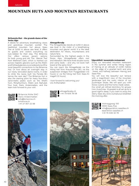
Britannia Hut – the grande dame of the<br />
Swiss Alps<br />
A desire for adventure, breathtaking views<br />
and grandiose mountain worlds! The<br />
traditional mountain hut above Saas-<br />
Fee at 3,030 m above sea level. It offers<br />
its guests and visitors everything nature-related<br />
for their stay. The Britannia<br />
Hut offers various ascent options<br />
for both young and old. The Glacier Trail<br />
from Mattmark Dam, which is marked out<br />
across majestic glaciers such as the Allalin<br />
and Hohlaub glaciers, is considered one of the<br />
most beautiful connections to the Britannia<br />
Hut. Or how about an overnight stay in<br />
our newly renovated alpine rooms, in order<br />
to climb the newly built Via Ferrata Britannia<br />
the next day? The Britannia Hut is<br />
also the starting point for many four-thousand-metre<br />
peaks such as the Strahlhorn,<br />
Rimpfischhorn, Allalin and Alphubel.<br />
Your host, Dario Andenmatten, and the<br />
team look forward to your visit.<br />
Britannia Hütte SAC<br />
Dario Andenmatten<br />
info@britannia.ch<br />
britannia.ch<br />
+41 27 957 22 88<br />
Almagelleralp<br />
The Almagelleralp stands at 2,200 m above<br />
sea level in the midst of a breathtaking<br />
mountain and glacier world. It is the ideal<br />
destination for hikers, mountaineers and<br />
nature fans.<br />
Surrounded by the highest peaks in the<br />
Swiss Alps, Almagelleralp offers rest<br />
and relaxation. We have three double rooms<br />
and camp beds – and why not book halfboard<br />
at the same time?<br />
You can reach the Almagelleralp via the<br />
hiking trail from Kreuzboden (3h), via the<br />
suspension bridges from Furggstalden (1.5<br />
hours) or via the hiking trail from Saas-Almagell<br />
(1.5 hours)<br />
I look forward to welcoming you!<br />
Urs Anthamatten<br />
almagelleralp.ch<br />
+41 79 629 78 08<br />
‘Alpenblick’ mountain restaurant<br />
Enjoy our renovated mountain restaurant<br />
in the <strong>summer</strong> and winter hiking region<br />
of Hannig at an altitude of 2,030 metres<br />
on the edge of a gnarled larch and pine<br />
forest, and halfway between Hannig and<br />
Saas-Fee.<br />
You will love the beautiful sun terrace<br />
with a magnificent view of the mountain<br />
landscape and the rustic interior of our<br />
Zuckmayer Stube. We will spoil you with<br />
Swiss cuisine and fine home-made cakes.<br />
Our small yet refined dormitory for groups<br />
(min. 6 and max. 10 people) is all set up for a<br />
good night’s sleep, if you want to enjoy the<br />
starry Saas sky and a sumptuous breakfast<br />
the morning after.<br />
Hohneggweg 100<br />
3906 Saas-Fee<br />
info@alpenblick-saasfee.ch<br />
alpenblick-saasfee.ch<br />
+41 76 539 32 78<br />
On this trail high above the treeline, you can enjoy unspoilt<br />
nature and a fantastic view over the Saas Valley and the<br />
Mischabel chain – with the highest mountains in Switzerland.<br />
The hike starts at the Kreuzboden mountain station above<br />
Saas-Grund at 2,400 m above sea level, which is easily<br />
accessible by gondola . Always surrounded by the four-thousand-metre<br />
peaks of Saas and with an unobstructed view of<br />
the Mattmark Dam, nature fans will reach the Almagellertal<br />
valley. Here follows the descent to the Almagelleralp mountain<br />
hotel with its striking red shutters. Once there, you can taste<br />
traditional dishes such as ‘smugglers’ macaroni’ and fresh fruit<br />
tarts. Then continue either via the adventure trail with two<br />
suspension bridges and ladders to Furggstalden, or via the<br />
direct trail to Saas-Almagell.<br />
Time requirement: approx. 3.5 hours<br />
Route: 10.5 kilometres<br />
Metres in altitude uphill: 204m<br />
Metres in altitude downhill: 931m<br />
Highest point: 2,522 m above sea level<br />
Lowest point: 1,671 m above sea level<br />
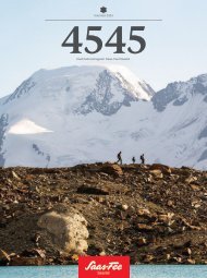
A MOUNTAIN SPANNING<br />
GENERATIONS<br />
The Hannig connects both young and old. A visit to this sunny<br />
mountain expanse creates experiences that interlink generations.<br />
Some are delighted by the goats that graze the<br />
alpine herbs here in <strong>summer</strong>. Others like to watch the birds and<br />
listen to the charming sounds of the marmots. And there are<br />
those who are simply happy about the ice cream in the mountain<br />
restaurant right next to the playground. The Hannig, with its<br />
comparatively easy hiking trails and rail access, is a family-centric<br />
mountain in the best possible sense. Here at 2,350 metres<br />
above sea level, generations come together to enjoy. The<br />
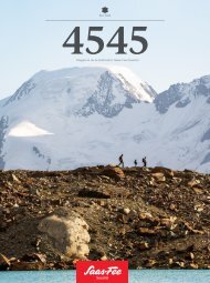
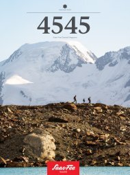
view at the foot of the Mischabel chain stretches from the<br />
4,545-metre-high Dom, over the white glaciers to the Weissmies.<br />
Everyone feels at home here.<br />
The Hannig is also ideally suited for bikers. Or even<br />
on scooters, the descent can then be tackled. Those who<br />
prefer it a little more leisurely can stroll down into the valley.<br />
This provides, for example, the opportunity to buy<br />
fresh goat’s cheese directly from the alpine cooperative<br />
shop just before the treeline. Further down on Melchboden,<br />
the recently renovated lake area with adjacent barbecue zone<br />
and large playground invites you to spend some quality time.<br />
4<br />
Discover the adventure worlds on p. 10<br />
Hannig<br />
saas-fee.ch/hannig<br />
40 41