Create successful ePaper yourself
Turn your PDF publications into a flip-book with our unique Google optimized e-Paper software.
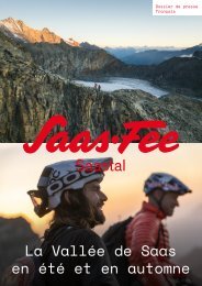
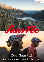
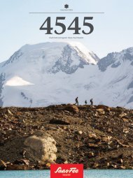
A CLASSIC AMONG KINGS<br />
Here, you always have the Mischabel Mountains<br />
in view and get to come close to Valais Blacknose<br />
sheep: the Gsponer Höhenweg is one of the most<br />
impressive hikes in the Saas Valley.<br />
Text: Patrick Gasser<br />
Image: Puzzle Media<br />
A small gondola runs from the station in Stalden in the direction<br />
of Gspon. This is the starting point for one of the most<br />
beautiful high-altitude trails in Switzerland. And it is also<br />
home to the highest football pitch in Europe. It is quite possible<br />
that some of the best free-kick takers ever grow up here.<br />
Anyone who blasts the ball over the fence here is unlikely to<br />
find it again in this steep, sloping terrain.<br />
The first section of the high-altitude trail is more leisurely<br />
than the search for the football in Gspon. Only from the<br />
hamlet of Oberfinilu does the wide path become a narrow hiking<br />
trail. The route alternates through forest and open spaces.<br />
The Gsponer Höhenweg starts quite comfortably on a<br />
wide farm track. Just right for a warm-up. Only from the hamlet<br />
of Oberfinilu does the path turn into a narrow hiking trail.<br />
The view frees up to reveal the almost 3,800-metre-high Balfrin,<br />
which lies to the west of Saas-Balen. But the view during<br />
the hike not only falls on the impressive mountains. It is not<br />
unusual to be surprised by the tinkling of bells from genuine<br />
locals: these being Valais Blacknose sheep. Even before the<br />
Romans, this breed came to the valleys of the Upper Valais –<br />
and today, it is just as typical of the region as raclette cheese<br />
and ‘Genepie’ – alpine herbal liqueur with glacier wormwood.<br />
The next ascent takes you to Siwiboden. It’s worth taking<br />
a break here for the magnificent view. This is because the<br />
path stretches for a total of five hours over a good 14 kilometres.<br />
A soothing, cooling effect<br />
Siwiboden is followed by the Linde Bodu. What’s important<br />
here: you should definitely keep an eye on the time, in order<br />
to catch the last mountain railway to Kreuzboden. This saves<br />
you almost 1,000 metres of descent to Saas-Grund. If there is<br />
not enough time, you can already start the descent directly<br />
to Saas-Balen or Saas-Grund via another trail option. If you<br />
make it to Kreuzboden, a soothing footbath awaits you at the<br />
mountain lake.<br />
However, this footbath has to be worked hard for<br />
again on the last section. This is because here, the hike becomes<br />
challenging once more with a section of trail that leads<br />
through a boulder landscape.<br />
Time requirement: approx. 5 hours<br />
Route: 14 kilometres<br />
Metres in altitude uphill: 740m<br />
Metres in altitude downhill: 236m<br />
Highest point: 2,470 m above sea level<br />
Lowest point: 1,865 m above sea level<br />
Great views: from the larch forest, the view<br />
of the imposing mountain scenery is unobstructed.<br />
THE SMUGGLER’S ROUTE<br />
For centuries, the Monto Moro Pass was an<br />
important route for trade between north and south.<br />
Even today, this period of history can be felt.<br />
Text: Patrick Gasser<br />
Image: Frederik Kalbermatten<br />
Anyone visiting the Italian municipality of Macugnaga for the<br />
first time will immediately notice the log cabin-style houses.<br />
Family names like ‘Zurbriggen’ or ‘Anthamatten’ do not sound<br />
typically Italian either. And indeed: in the 12th century, entire<br />
families emigrated from the Saas Valley over the Monte Moro<br />
Pass to what is now the province of Verbano-Cusio-Ossola.<br />
For hundreds of years, the language and culture remained<br />
similar to those on the other side of the Monte Moro Pass.<br />
Those who set out on this cross-border hike today<br />
from the Mattmark Dam do so on the same stone slabs as<br />
smugglers have done for hundreds of years. Salt, wine,<br />
cheese, sheep – and later on even cigarettes found their<br />
way over the pass. The people of Saas bought jewellery and<br />
cooking utensils from the traders at the weekly market in<br />
Macugnaga.<br />
The hike begins on the circular trail around Lake Mattmark.<br />
Embedded in an impressive mountain backdrop, the<br />
water glistens in the most beautiful emerald shades. Hikers<br />
leave the mostly asphalted path at the Distel Alp at the end of<br />
the dam.<br />
From there, a well-marked hiking trail climbs to Tälliboden,<br />
a pretty moorland. The scenery further up to the Golden<br />
Madonna is rugged. Here, you walk along the remains of<br />
the centuries-old paved mule track. The statue ‘Maria zum<br />
Schnee’ is of great significance for the inhabitants on both<br />
sides of the pass. A cross-border pilgrimage mass is held here<br />
on 5 August every year. The statue is enthroned at the top of<br />
the pass with a view towards Italy.<br />
Not far from the top of the pass is the station of the<br />
gondola lift to Macugnaga. A detour to eat pizza in the Walser<br />
village is always worthwhile. The way back takes you via the<br />
same route as the ascent to Monte Moro Pass. If you want to<br />
return the same day, however, be sure to follow the timetable<br />
of the mountain railway back up. The same applies to the<br />
bus timetable from the dam crest at Lake Mattmark back to<br />
Saas-Almagell.<br />
Time requirement: approx. 5<br />
hours, there and back<br />
Route: 14.5 kilometres<br />
Metres in altitude uphill: 642m<br />
Metres in altitude downhill: 642m<br />
Highest point: 2,840 m above sea level<br />
Lowest point: 2,200 m above sea level<br />
On the historic route to the Monte Moro Pass,<br />
you always have Lake Mattmark in view.<br />
22 23