Toilets - Yorkshire Dales National Park
Toilets - Yorkshire Dales National Park Toilets - Yorkshire Dales National Park
N Kendal B B6255 Widdale Gayle Swaledale 1 2 A Hawes NPC CP PT RADAR ▲ Wether Fell W e n s l e y d a l e A684 Semer Water Raydale Bainbridge PT RADAR River Bain 3 Askrigg RADAR ▲ Addlebrough River Ure 14 15 B6160 4 NPC CP PT RADAR 2 A Aysgarth NPC CP PT RADAR Bishopdale A Road B Road Minor road Lake or river National Park Centre Car park Public toilet RADAR toilet Place of interest Accessible route Carperby C West Burton Leyburn © Crown copyright. All rights reserved 100023740 2010
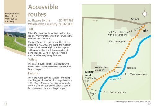
Footpath from Hawes to the Wensleydale Creamery 16 Accessible routes A. Hawes to the SD 874898 Wensleydale Creamery SD 870895 Trail This 450m linear public footpath follows the Pennine Way from the church in Hawes to the Wensleydale Creamery. The first 70m of the trail are cobbled with a gradient of 1:7. After this point, the footpath levels out with some slight gradients up to 1:10. Most of the length is constructed of stone flags at a width of 100cm. There is a rest area halfway along the route. Toilets The nearest public toilets, including RADAR facility toilets, are in the Hawes National Park Centre car park. Parking There are public parking facilities - including nine designated bays for blue badge holders - in the Hawes National Park Centre car park. There is a further pay and display car park in the town centre. Normal charges apply. A684 Wensleydale Creamery Turning point return same way Gayle First 70m cobbles with a 1:7 gradient 150cm wide gate Gayle Beck 2 x 115cm wide gates Hawes Rest area N Start 2 x 100cm wide gates © Crown copyright. All rights reserved 100023740 2010 17
- Page 1 and 2: We would like to thank the Yorkshir
- Page 3 and 4: Below: Dales Countryside Museum, Ha
- Page 5 and 6: 8 Bainbridge Bainbridge SD 935904 T
- Page 7: Wigeon 12 3. Semer Water SD 920875
- Page 11 and 12: Aysgarth Falls 20 C. Aysgarth Falls
- Page 13 and 14: 24 Help us safeguard our precious l
Footpath from<br />
Hawes to the<br />
Wensleydale<br />
Creamery<br />
16<br />
Accessible<br />
routes<br />
A. Hawes to the SD 874898<br />
Wensleydale Creamery SD 870895<br />
Trail<br />
This 450m linear public footpath follows the<br />
Pennine Way from the church in Hawes to the<br />
Wensleydale Creamery.<br />
The first 70m of the trail are cobbled with a<br />
gradient of 1:7. After this point, the footpath<br />
levels out with some slight gradients up to<br />
1:10. Most of the length is constructed of<br />
stone flags at a width of 100cm. There is<br />
a rest area halfway along the route.<br />
<strong>Toilets</strong><br />
The nearest public toilets, including RADAR<br />
facility toilets, are in the Hawes <strong>National</strong> <strong>Park</strong><br />
Centre car park.<br />
<strong>Park</strong>ing<br />
There are public parking facilities - including<br />
nine designated bays for blue badge holders -<br />
in the Hawes <strong>National</strong> <strong>Park</strong> Centre car park.<br />
There is a further pay and display car park in<br />
the town centre. Normal charges apply.<br />
A684<br />
Wensleydale<br />
Creamery<br />
Turning<br />
point<br />
return same<br />
way<br />
Gayle<br />
First 70m cobbles<br />
with a 1:7 gradient<br />
150cm wide gate<br />
Gayle Beck<br />
2 x 115cm wide gates<br />
Hawes<br />
Rest area<br />
N<br />
Start<br />
2 x 100cm wide gates<br />
© Crown copyright. All rights reserved 100023740 2010<br />
17


