Toilets - Yorkshire Dales National Park
Toilets - Yorkshire Dales National Park
Toilets - Yorkshire Dales National Park

You also want an ePaper? Increase the reach of your titles
YUMPU automatically turns print PDFs into web optimized ePapers that Google loves.
We would like to thank the<br />
<strong>Yorkshire</strong> <strong>Dales</strong> <strong>National</strong> <strong>Park</strong><br />
Authority’s Access for All Advisory<br />
Group for their help and advice in the<br />
compilation of this leaflet.<br />
This leaflet can be supplied in other<br />
formats on request. Please contact the<br />
Access Development Officer on 01969 652363.<br />
Other guides available:<br />
• Access for All in the <strong>Yorkshire</strong> <strong>Dales</strong><br />
• Access for All in Wharfedale<br />
• Access for All in Garsdale, Dentdale and Sedbergh<br />
• Access for All in Swaledale and Arkengarthdale<br />
Photographs by: Whitfield Benson, Michael Briggs, Jonah Tosney and Rachel Briggs.<br />
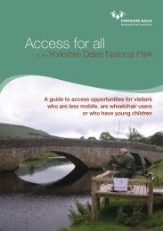
Cover image: wheelchair-accessible fishing platforms near Hawes.<br />
© <strong>Yorkshire</strong> <strong>Dales</strong> <strong>National</strong> <strong>Park</strong> Authority, March 2010<br />
Printed on 80% recycled paper<br />
Designed and produced by www.bowhouse.co.uk<br />
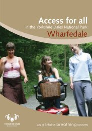
Access for all<br />
in the <strong>Yorkshire</strong> <strong>Dales</strong> <strong>National</strong> <strong>Park</strong><br />
One of<br />
Wensleydale
2<br />
Introduction<br />
The <strong>Yorkshire</strong> <strong>Dales</strong> is an<br />
amazing place where you will find<br />
outstanding wildlife, rich cultural<br />
heritage and many opportunities<br />
to enjoy the unique qualities the<br />
area has to offer. In 1954, the<br />
<strong>Yorkshire</strong> <strong>Dales</strong> was designated a<br />
<strong>National</strong> <strong>Park</strong> in recognition of<br />
these special qualities.<br />
Left: River Ure at<br />
Bainbridge<br />
Below: Bus at<br />
Askrigg<br />
This guide has been produced to provide<br />
information about access opportunities in<br />
Wensleydale for visitors who are less mobile,<br />
are wheelchair users or have young children.<br />
The guide is not definitive, but offers a<br />
selection of natural and heritage attractions<br />
for mixed ability parties as well as essential<br />
information such as the location of<br />
information centres, car parks and toilets.<br />
We have also suggested a number of trails,<br />
describing the terrain and any potential<br />
obstacles along the route.<br />
If you have any comments to make about<br />
this guide, please contact the <strong>Yorkshire</strong> <strong>Dales</strong><br />
<strong>National</strong> <strong>Park</strong> Authority’s Access Development<br />
Officer on 01969 652363.<br />
Public transport<br />
For information on public transport in the<br />
area, call Travel Line on 0871 200 22 33 or<br />
visit www.traveldales.org.uk. Some bus and<br />
train services in Wensleydale run wheelchair<br />
accessible services.<br />
Car parking<br />
Some of the parking areas detailed within<br />
this booklet are informal with space for a<br />
few vehicles only and no specific facilities<br />
for people with disabilities.<br />
Please give consideration to where and<br />
how vehicles are parked so as not to cause<br />
inconvenience to others.<br />
3
Below: <strong>Dales</strong><br />
Countryside<br />
Museum, Hawes<br />
Right: Gayle<br />
4<br />
RADAR toilets<br />
The <strong>National</strong> Key Scheme (NKS) was set up<br />
to allow independent entry by disabled key<br />
holders to accessible public toilets fitted with<br />
the NKS lock. There are around 7,000<br />
throughout the UK.<br />
RADAR toilets are located at Askrigg, Aysgarth,<br />
Bainbridge, Hawes and Leyburn.<br />
For more information or to obtain a RADAR<br />
key, please call 020 7250 3222, visit<br />
www.radar.org.uk or write to:<br />
RADAR, 12 City Forum<br />
250 City Road<br />
London EC1V 8AF<br />
Further information<br />
To find out more about opportunities to relax<br />
and enjoy the peace and quiet of the beautiful<br />
<strong>Yorkshire</strong> <strong>Dales</strong>, where to stay, how to get here<br />
and more, please contact a <strong>National</strong> <strong>Park</strong> or<br />
Tourist Information Centre.<br />
Aysgarth Falls <strong>National</strong> <strong>Park</strong> Centre<br />
Tel: 01969 622910<br />
Email: aysgarth@yorkshiredales.org.uk<br />
Hawes <strong>National</strong> <strong>Park</strong> Centre<br />
Tel: 01969 666210<br />
Email: hawes@yorkshiredales.org.uk<br />
Leyburn Tourist Information Centre<br />
Tel: 01748 828747<br />
Email: leyburntic@richmondshire.gov.uk<br />
Settlements<br />
For hundreds of years, people have<br />
lived in Wensleydale, building the<br />
structures which housed their industries,<br />
ceremonies, festivities and homes.<br />
These buildings now remain for us to<br />
enjoy as our shared heritage.<br />
5
6<br />
Hawes church<br />
Hawes with Gayle SD 876898<br />
The busy town of Hawes received its market<br />
charter in 1700. A coach road from Richmond<br />
to Lancaster was completed in 1795 and the<br />
arrival of the railway in 1878 confirmed it as<br />
the ‘capital of Wensleydale’.<br />
<strong>Toilets</strong><br />
There are public toilets, including RADAR<br />
facility toilets, in the Hawes <strong>National</strong> <strong>Park</strong><br />
Centre car park and town centre.<br />
<strong>Park</strong>ing<br />
There are public parking facilities - including<br />
nine designated bays for blue badge holders -<br />
in the Hawes <strong>National</strong> <strong>Park</strong> Centre car park.<br />
There is a further pay and display car park in<br />
the town centre. Normal charges apply.<br />
General<br />
Famous for its cheese, the Wensleydale<br />
Creamery has a visitor centre with museum,<br />
shop and restaurant. The visitor centre is<br />
fully accessible with accessible toilets and<br />
designated parking for people with disabilities.<br />
Contact 01969 667664 or visit<br />
www.wensleydale.co.uk.<br />
West Burton<br />
waterfalls<br />
West Burton SE 019867<br />
West Burton is a beautiful <strong>Dales</strong> village,<br />
with a large central green, in the quiet<br />
valley of Walden.<br />
West Burton waterfalls (also known locally as<br />
Cauldron Falls) can be easily viewed from the<br />
car park. Both the waterfall and woodland are<br />
peaceful and scenic (although access is difficult<br />
following flood damage) - a good place to<br />
relax and enjoy a picnic.<br />
<strong>Toilets</strong><br />
The nearest public toilets, including RADAR<br />
facility toilets, are in the Aysgarth Falls <strong>National</strong><br />
<strong>Park</strong> Centre car park.<br />
<strong>Park</strong>ing<br />
There is no public parking in the village;<br />
parking tends to be on the roadside. There<br />
is an informal parking area at the waterfalls.<br />
General<br />
Vehicular access to the village and waterfall<br />
is via narrow roads which are steep in places.<br />
7
8<br />
Bainbridge<br />
Bainbridge SD 935904<br />
The village of Bainbridge is centred around a<br />
spacious village green complete with stocks.<br />
The River Bain, the shortest river in England,<br />
flows from Lake Semer Water over a<br />
picturesque waterfall near the village.<br />
<strong>Toilets</strong><br />
There are public toilets, including RADAR<br />
facility toilets, in the village centre.<br />
<strong>Park</strong>ing<br />
There is some general parking on the road<br />
or at the public toilet area.<br />
General<br />
Bainbridge green is a great place to relax<br />
and have a picnic.<br />
Askrigg<br />
Askrigg SD 948911<br />
Viewers of the long-running BBC TV series<br />
‘All Creatures Great and Small’ will recognise<br />
Askrigg as the home of Skeldale House,<br />
where vet James Herriot lived.<br />
The village’s cobbled streets and tall houses<br />
make Askrigg a worthwhile place to stop for<br />
refreshment.<br />
<strong>Toilets</strong><br />
There are public toilets, including RADAR<br />
facility toilets, in the village hall.<br />
<strong>Park</strong>ing<br />
There is some general parking on the roadside.<br />
General<br />
Many of the footpaths and roads in Askrigg<br />
are cobbled and sloping. The main street<br />
(Station Road) has a particularly steep gradient.<br />
9
The old train<br />
carriage hosts<br />
displays at the<br />
<strong>Dales</strong> Countryside<br />
Museum, Hawes<br />
10<br />
Places of<br />
interest<br />
1. <strong>Dales</strong> Countryside SD 877898<br />
Museum, Hawes<br />
At the <strong>Dales</strong> Countryside Museum you can<br />
experience what life was once like in the<br />
beautiful, but sometimes harsh, landscape<br />
of the <strong>Yorkshire</strong> <strong>Dales</strong>.<br />
<strong>Toilets</strong><br />
There are public toilets, including RADAR<br />
facility toilets, in the car park. Adapted toilets<br />
are also available in the entrance hall of the<br />
Museum for all visitors.<br />
<strong>Park</strong>ing<br />
There are public parking facilities - including<br />
nine designated bays for blue badge holders -<br />
in the Hawes <strong>National</strong> <strong>Park</strong> Centre car park.<br />
Normal charges apply.<br />
General<br />
The Museum has been adapted for disabled<br />
access throughout, with wide aisles, lifts,<br />
ramps and a two-level information counter.<br />
Please note, there is an admission charge into<br />
the Museum exhibition areas; carers enter<br />
free of charge.<br />
Contact details<br />
Telephone 01969 666210.<br />
Fishing at Haylands<br />
Bridge<br />
2. Haylands Bridge SD 876904<br />
Fishing Platforms,<br />
Hawes<br />
Two adapted fishing platforms suitable for<br />
wheelchair users are situated on the River Ure<br />
at Hawes. Whilst fishing for brown trout and<br />
grayling, look out for various birds, such as<br />
dippers, grey wagtails, kingfishers and<br />
sand martins.<br />
<strong>Toilets</strong><br />
The nearest public toilets, including RADAR<br />
facility toilets, are in the Hawes <strong>National</strong><br />
<strong>Park</strong> Centre car park.<br />
<strong>Park</strong>ing<br />
There is accessible, off road, parking at<br />
Haylands Bridge for four cars.<br />
Contact details<br />
Day tickets are available from the <strong>Dales</strong><br />
Countryside Museum in Hawes. Telephone<br />
01969 666210.<br />
11
Wigeon<br />
12<br />
3. Semer Water SD 920875<br />
Just south of Bainbridge lies Semer Water, one<br />
of <strong>Yorkshire</strong>’s few natural lakes. According to<br />
legend, a town once stood where the water<br />
now runs deep, but it was doomed to a watery<br />
grave after a weary traveller was refused<br />
shelter from a raging storm. As he left he<br />
cursed the town, decreeing that it should be<br />
drowned under rushing waters.<br />
Semer Water is a great place to relax and enjoy<br />
a picnic, with good views of the lake and<br />
Raydale from the parking area.<br />
Take your binoculars and you may see overwintering<br />
ducks, oystercatchers, great crested<br />
grebes, wigeon, buzzard and sand pipers.<br />
<strong>Toilets</strong><br />
The nearest public toilets, including RADAR<br />
facility toilets, are in Bainbridge village.<br />
<strong>Park</strong>ing<br />
There is an informal parking area on the<br />
northern shore of the lake. A small car parking<br />
charge is made by nearby Low Blean Farm.<br />
Common blue<br />
butterfly<br />
4. Ballowfields SD 988898<br />
Ballowfields is one of six Local Nature Reserves<br />
owned and managed by the <strong>Yorkshire</strong> <strong>Dales</strong><br />
<strong>National</strong> <strong>Park</strong> Authority.<br />
In the 1930s, despite local outcry, a number<br />
of holiday chalets were built on this site which<br />
also supported a shop, café, village hall and<br />
swimming pool. During the war, some of the<br />
chalets were let to women and children who<br />
had been evacuated to the country from the<br />
north east and Gateshead. After the war, the<br />
holiday village fell into disrepair. The land<br />
was purchased by the council, which knocked<br />
the chalets down one by one and landscaped<br />
the area.<br />
Ballowfields is a great place to relax and enjoy<br />
a picnic. In early May the area is carpeted with<br />
thrift leaving a pink blaze of colour. Late<br />
August is good for devil’s bit scabious - look<br />
out for the blue haze. You may also see a<br />
common blue butterfly.<br />
<strong>Toilets</strong><br />
The nearest public toilets, including RADAR<br />
facility toilets, are in the Aysgarth Falls <strong>National</strong><br />
<strong>Park</strong> Centre car park.<br />
<strong>Park</strong>ing<br />
There is a small car parking area at the Local<br />
Nature Reserve.<br />
13
N<br />
Kendal<br />
B<br />
B6255<br />
Widdale<br />
Gayle<br />
Swaledale<br />
1 2<br />
A<br />
Hawes<br />
NPC<br />
CP PT<br />
RADAR<br />
▲<br />
Wether Fell<br />
W e n s l e y d a l e<br />
A684<br />
Semer<br />
Water<br />
Raydale<br />
Bainbridge<br />
PT RADAR<br />
River Bain<br />
3<br />
Askrigg<br />
RADAR<br />
▲<br />
Addlebrough<br />
River Ure<br />
14 15<br />
B6160<br />
4<br />
NPC<br />
CP<br />
PT<br />
RADAR<br />
2<br />
A<br />
Aysgarth<br />
NPC<br />
CP PT<br />
RADAR<br />
Bishopdale<br />
A Road<br />
B Road<br />
Minor road<br />
Lake or river<br />
<strong>National</strong> <strong>Park</strong> Centre<br />
Car park<br />
Public toilet<br />
RADAR toilet<br />
Place of interest<br />
Accessible route<br />
Carperby<br />
C<br />
West Burton<br />
Leyburn<br />
© Crown copyright. All rights reserved 100023740 2010
Footpath from<br />
Hawes to the<br />
Wensleydale<br />
Creamery<br />
16<br />
Accessible<br />
routes<br />
A. Hawes to the SD 874898<br />
Wensleydale Creamery SD 870895<br />
Trail<br />
This 450m linear public footpath follows the<br />
Pennine Way from the church in Hawes to the<br />
Wensleydale Creamery.<br />
The first 70m of the trail are cobbled with a<br />
gradient of 1:7. After this point, the footpath<br />
levels out with some slight gradients up to<br />
1:10. Most of the length is constructed of<br />
stone flags at a width of 100cm. There is<br />
a rest area halfway along the route.<br />
<strong>Toilets</strong><br />
The nearest public toilets, including RADAR<br />
facility toilets, are in the Hawes <strong>National</strong> <strong>Park</strong><br />
Centre car park.<br />
<strong>Park</strong>ing<br />
There are public parking facilities - including<br />
nine designated bays for blue badge holders -<br />
in the Hawes <strong>National</strong> <strong>Park</strong> Centre car park.<br />
There is a further pay and display car park in<br />
the town centre. Normal charges apply.<br />
A684<br />
Wensleydale<br />
Creamery<br />
Turning<br />
point<br />
return same<br />
way<br />
Gayle<br />
First 70m cobbles<br />
with a 1:7 gradient<br />
150cm wide gate<br />
Gayle Beck<br />
2 x 115cm wide gates<br />
Hawes<br />
Rest area<br />
N<br />
Start<br />
2 x 100cm wide gates<br />
© Crown copyright. All rights reserved 100023740 2010<br />
17
Cotter Force<br />
18<br />
B. Cotter Force SD 850915<br />
Known as ‘the valley of the waterfalls’,<br />
Wensleydale harbours many delights for the<br />
visitor. Cotter Force, west of Hawes, is a lovely<br />
secluded waterfall in a wooded setting. It is a<br />
series of about half a dozen waterfalls with the<br />
largest single drop being about 1.5m. The force<br />
widens as it descends being only a couple of<br />
feet wide at the top and about 4.5m wide at<br />
the bottom.<br />
Trail<br />
This 490m level footpath alongside the beck is<br />
constructed of compact stone with a general<br />
width of 110cm. There are three seating areas<br />
evenly spaced along the footpath.<br />
Whilst walking the route look out for dippers,<br />
grey wagtails, redstarts, long tailed tits and<br />
kingfishers.<br />
<strong>Toilets</strong><br />
The nearest public toilets, including RADAR<br />
facility toilets, are in the Hawes <strong>National</strong> <strong>Park</strong><br />
Centre car park.<br />
<strong>Park</strong>ing<br />
There is a pull-in for three cars, but with<br />
limited width for wheelchairs.<br />
Garsdale<br />
River Ure<br />
Turning point<br />
return same way<br />
Seating area<br />
Seating area<br />
Holme Heads Bridge<br />
Informal parking area<br />
for up to three cars<br />
Start<br />
N<br />
The first 17m<br />
has gradients<br />
up to 1:9<br />
Hawes<br />
© Crown copyright. All rights reserved 100023740 2010<br />
19
Aysgarth Falls<br />
20<br />
C. Aysgarth Falls and SE 012888<br />
Freeholders’ Wood<br />
Aysgarth Falls is a series of cascading waterfalls<br />
separated into three forces, Higher, Middle and<br />
Lower. Higher Falls is the most vigorous of the<br />
group whereas Middle Falls has the largest<br />
single drop of around 2m. Lower Falls is in<br />
the most serene setting.<br />
Trail<br />
The first 500m of this 1.5km footpath runs<br />
through Freeholders’ Wood and has great<br />
views of the Middle Falls. The surface here<br />
is compact aggregate and the width of the<br />
footpath is at least 100cm. All gates are fully<br />
accessible and there are seating areas along<br />
the route.<br />
From here, a flight of seventy steps provide<br />
access to the Lower Falls. Alternatively, the<br />
footpath continues for a further 1km along<br />
an unsurfaced grass route.<br />
A further route can be followed from the start,<br />
along a muddy track through the woodland.<br />
<strong>Toilets</strong><br />
The nearest public toilets, including RADAR<br />
facility toilets, are in the Aysgarth Falls<br />
<strong>National</strong> <strong>Park</strong> Centre car park.<br />
<strong>Park</strong>ing<br />
There are public parking facilities - including<br />
four designated bays for blue badge holders -<br />
in the Aysgarth Falls <strong>National</strong> <strong>Park</strong> Centre car<br />
park. Normal charges apply.<br />
N<br />
<strong>National</strong><br />
<strong>Park</strong> Centre<br />
Start<br />
120cm wide gate at<br />
start of route with<br />
two seating areas<br />
Turning<br />
point<br />
Grass surface<br />
120cm wide gate<br />
and seating area<br />
Turning point<br />
return same way<br />
300cm<br />
wide gate<br />
River Ure<br />
Seating area<br />
120cm<br />
wide gate<br />
Steps to<br />
lower falls<br />
© Crown copyright. All rights reserved 100023740 2010<br />
21
Below: Access for<br />
All in Swaledale and<br />
Arkengarthdale<br />
Right: Swaledale<br />
sheep<br />
22<br />
Useful information<br />
The <strong>Yorkshire</strong> <strong>Dales</strong> <strong>National</strong> <strong>Park</strong> Authority<br />
has also published four other booklets: ‘Access<br />
for All in the <strong>Yorkshire</strong> <strong>Dales</strong>, ‘Access for All in<br />
Swaledale and Arkengarthdale’, ‘Access for All<br />
in Garsdale, Dentdale and Sedbergh’ and<br />
‘Access for All in Wharfedale’. These detail<br />
access opportunities in these areas for visitors<br />
with disabilities, as well as the location of<br />
facilities such as toilets and car parking.<br />
For a free copy contact the Access<br />
Development Officer on 01969 652363.<br />
For more detail of the area and routes<br />
described in this leaflet, refer to the following<br />
Ordnance Survey Explorer maps:<br />
Explorer OL30 - 1: 25 000 scale<br />
<strong>Yorkshire</strong> <strong>Dales</strong> Northern and Central Areas<br />
Explorer OL2 - 1: 25 000 scale<br />
<strong>Yorkshire</strong> <strong>Dales</strong> Southern and Western Areas<br />
Explorer OL19 - 1: 25 000 scale<br />
Howgill Fells and Upper Eden Valley<br />
Countryside Code<br />
• Be safe - plan ahead and follow any signs.<br />
• Leave gates and property as you find them.<br />
• Protect plants and animals, and take your<br />
litter home.<br />
• Keep dogs under close control.<br />
• Consider other people.<br />
View the full Countryside Code at<br />
www.countrysideaccess.gov.uk.<br />
23
24<br />
Help us safeguard our<br />
precious landscape<br />
Did you know that over 98% of land in<br />
the <strong>National</strong> <strong>Park</strong> is privately owned?<br />
<strong>National</strong> <strong>Park</strong> Authority Rangers have an<br />
important role to play in maintaining the<br />
balance between the needs of residents who<br />
live and work in the <strong>National</strong> <strong>Park</strong> and the<br />
desire of visitors to share in the beauty of<br />
this special place.<br />
Left: Upper<br />
Wensleydale Area<br />
Ranger<br />
Below: Semer Water<br />
You can help by following the Ranger Code:<br />
• Keep your dogs under close control,<br />
preferably on a lead.<br />
• Keep to public rights of way and<br />
access areas.<br />
• Avoid trampling meadow grass by staying<br />
in single file through meadows in summer -<br />
grass is winter food for sheep and cattle.<br />
• Leave livestock, crops and machinery alone.<br />
• Take only memories home, not wild flowers<br />
or plants.<br />
• Dress and equip yourself to suit the weather,<br />
the location, the walking conditions and<br />
length of time you are going to be out;<br />
always take the clothing and equipment<br />
you might need.<br />
• <strong>Park</strong> thoughtfully, and try to use<br />
designated car parks where available.<br />
• Take special care when driving on narrow<br />
roads, especially during lambing time in<br />
April and May.<br />
• Give your car a break - leave the car at<br />
home and use environmentally-friendly<br />
public transport where possible.<br />
• Enjoy the countryside and respect its life<br />
and work.<br />
25
Red squirrel<br />
26<br />
Useful contacts and<br />
further information<br />
The <strong>Yorkshire</strong> <strong>Dales</strong> <strong>National</strong> <strong>Park</strong> Authority<br />
is committed to providing opportunities for<br />
enjoyment and understanding throughout<br />
the area.<br />
If you have any comments on the content of this<br />
leaflet please contact the Access Development<br />
Officer Rachel Briggs on 01969 652363 or<br />
rachel.briggs@yorkshiredales.org.uk. You can<br />
also write to us at:<br />
<strong>Yorkshire</strong> <strong>Dales</strong> <strong>National</strong> <strong>Park</strong> Authority,<br />
FREEPOST BD625, Grassington, Skipton,<br />
North <strong>Yorkshire</strong> BD23 1BR.<br />
The Authority’s website offers advice on<br />
accessible services, attractions,<br />
accommodation, trails, toilets and viewpoints.<br />
Visit the ‘Out and About’ section of<br />
www.yorkshiredales.org.uk and look up<br />
‘Planning your visit’ to find out more.<br />
Notes<br />
27