Stewart R. Wallace — 1919–2009 - Society of Economic Geologists
Stewart R. Wallace — 1919–2009 - Society of Economic Geologists
Stewart R. Wallace — 1919–2009 - Society of Economic Geologists

Create successful ePaper yourself
Turn your PDF publications into a flip-book with our unique Google optimized e-Paper software.
JULY 2009 No 78 SEG NEWSLETTER 13<br />
Discovery and Geology <strong>of</strong> the Platinum Group Element<br />
Deposits <strong>of</strong> the Bushveld Complex, South Africa<br />
ROGER N. SCOON (SEG 1985 F), † Postnet Suite 291, Private Bag X31, Knysna 6570, South Africa, and ANDREW A. MITCHELL<br />
(SEG 2001 F), Department <strong>of</strong> Geology, University <strong>of</strong> KwaZulu-Natal, Private Bag X54001, Durban 4000, South Africa<br />
INTRODUCTION<br />
The Bushveld Complex, which<br />
includes the largest known<br />
mafic intrusion in the world,<br />
reveals some spectacular geology,<br />
including the classic layering<br />
<strong>of</strong> dark ultramafics and<br />
light-colored anorthositic rocks<br />
(Fig. 1). Three distinct groups <strong>of</strong><br />
rocks make up the complex<br />
(Tankard et al., 1982), the oldest<br />
<strong>of</strong> which is the Rooiberg<br />
Group (dominated by rhyolite)<br />
and the youngest, the Lebowa<br />
Granite Suite (including a suite<br />
<strong>of</strong> granophyres). The majority<br />
<strong>of</strong> the ore deposits are, however,<br />
restricted to the intervening<br />
group <strong>of</strong> ultramafic-mafic<br />
rocks, or Rustenburg Layered<br />
Suite. The Rustenburg Layered<br />
Suite is intrusive into the sedimentary<br />
rocks and subordinate<br />
volcanic rocks <strong>of</strong> the Transvaal<br />
Supergroup (ca. 2.5–2.1 Ga) and has<br />
been dated at 2.055 Ga (Scoates and<br />
Friedman, 2008). The Bushveld contains<br />
the greatest concentration <strong>of</strong> mineral<br />
wealth on the planet and includes, in<br />
addition to the platinum group element<br />
(PGE) ores, base metals (e.g., chromium,<br />
iron, tin, titanium, and vanadium) and<br />
industrial minerals (e.g., andalusite,<br />
dimension stone, and magnesite), as<br />
described by Willemse (1969) and<br />
Wilson and Anhaeusser (1988). Mining<br />
operations have spawned extensive<br />
towns and associated industrial complexes,<br />
including downstream processing<br />
plants with smelters and precious<br />
metal refineries, many <strong>of</strong> which use<br />
technology specifically designed for the<br />
Bushveld ores.<br />
THE RUSTENBURG<br />
LAYERED SUITE<br />
The Rustenburg Layered Suite forms<br />
three principal limbs (Fig. 2) together<br />
† Corresponding author:<br />
e-mail, rnscoon@iafrica.com<br />
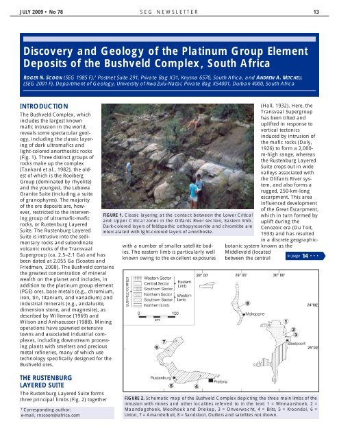
FIGURE 1. Classic layering at the contact between the Lower Critical<br />
and Upper Critical zones in the Olifants River section, Eastern limb.<br />
Dark-colored layers <strong>of</strong> feldspathic orthopyroxenite and chromitite are<br />
intercalated with light-colored layers <strong>of</strong> anorthosite.<br />
with a number <strong>of</strong> smaller satellite bodies.<br />
The eastern limb is particularly well<br />
known owing to the excellent exposures<br />
(Hall, 1932). Here, the<br />
Transvaal Supergroup<br />
has been tilted and<br />
uplifted in response to<br />
vertical tectonics<br />
induced by intrusion <strong>of</strong><br />
the mafic rocks (Daly,<br />
1926) to form a 2,000m-high<br />
range, whereas<br />
the Rustenburg Layered<br />
Suite crops out in wide<br />
valleys associated with<br />
the Olifants River system,<br />
and also forms a<br />
rugged, 250-km-long<br />
escarpment. This area<br />
influenced development<br />
<strong>of</strong> the Great Escarpment,<br />
which in turn formed by<br />
uplift during the<br />
Cenozoic era (Du Toit,<br />
1933) and has resulted<br />
in a discrete geographicbotanic<br />
system known as the<br />
Middleveld (located<br />
between the central<br />
to page 14 ...<br />
FIGURE 2. Schematic map <strong>of</strong> the Bushveld Complex depicting the three main limbs <strong>of</strong> the<br />
intrusion with mines and other localities referred to in the text: 1 = Winnaarshoek, 2 =<br />
Maandagshoek, Mooihoek and Driekop, 3 = Onverwacht, 4 = Brits, 5 = Kroondal, 6 =<br />
Union, 7 = Amandelbult, 8 = Sandsloot. Outliers and satellites not shown.