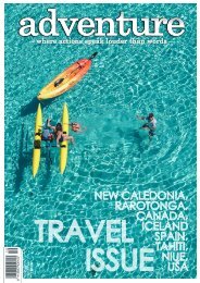
Adventure Magazine
Issue 230, February/March 2022
Issue 230, February/March 2022

Create successful ePaper yourself
Turn your PDF publications into a flip-book with our unique Google optimized e-Paper software.
After chatting with the staff at the info centre at<br />
Whapakapapa Village we decided not to risk an<br />
unnecessary turn around if the river was indeed<br />
too high, and instead parked at the village and<br />
walked into the hut via the Bruce Road. We have<br />
been coming to Whakapapa to ski since we were<br />
in our teens, yet this is the first time we had both<br />
walked up the Bruce Road. It was one of those<br />
misty, cold, wet days where you couldn’t see the<br />
mountain, actually you couldn’t see very far ahead<br />
of you in any direction.<br />
From the start of the track just past scoria flat it<br />
was another 3km or so to the hut and by then<br />
the rain had stopped and the mist was lifting<br />
somewhat. Coming into the track from the upper<br />
access wasn’t what we had planned but we<br />
happily traversed across the undulating rocky<br />
terrain before climbing to the highest point on the<br />
trail. As we reached the crest, we were literally<br />
stopped dead in our tracks by the view that<br />
opened in front of us. Waterfalls cascaded down<br />
sheer cliffs from the slopes of Ruapehu into the<br />
Whakapapaiti Valley below. It was an incredible<br />
sight. We sat in awe of what was less than an<br />
hour’s walk from the place we had been visiting<br />
for over 40 years.<br />
From the crest of the trail it was another half an<br />
hour or so down a steep slope via a succession<br />
of switchbacks to the turnoff to the Whakapapaiti<br />
Valley Track and another half hour to the hut. As<br />
we dropped in elevation, the terrain changed from<br />
bare rocks to mountain beech trees that had taken<br />
hold alongside the tributaries of the Whakapapaiti<br />
Stream.<br />
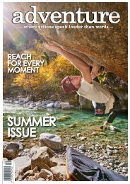
It was here that the hut was located, an 18-bunk<br />
spacious serviced hut with a great fire and an<br />
even greater deck with views up towards Mt<br />
Ruapehu and the cascading waterfalls. After a<br />
relaxing lunch we headed down to check out the<br />
river, and were glad that we had chosen the upper<br />
access as we were unable to find a safe crossing.<br />
Hiking in early November, we encountered<br />
only one person on the trail and had the hut to<br />
ourselves. There was a certain freedom to having<br />
the valley all to ourselves, including a skinny dip<br />
in one of the waterfalls only minutes from the hut,<br />
secure in the fact that we wouldn’t see another<br />
person for a while yet. So, you can imagine our<br />
surprise when we woke around 5.30am to the<br />
sound of voices. Peeking out the hut door we<br />
saw two guys running past the hut, stopping for a<br />
quick stretch before taking off again. They were<br />
running the Round the Mountain Track, being<br />
picked up later in the day by their dutiful partners.<br />
Although impressed with this level of fitness and<br />
commitment, we could not help but wonder what<br />
they missed along the way by running the whole<br />
thing in one day, however, each to their own.<br />
Previous page: One of the good things about hiking in the rain was the abundant waterfalls<br />
Above: Looking out from the crest of the hill not far from Scoria Flat<br />
Top Left: Whakapapaiti Hut / Top Right: The start of the Whakapapaiti Track above Scoria Flat